

Experiences

Education
HE YANG
+86 13535184415
heyangg98@gmail.com
University of Melbourne Master of Urban Design
University of Central Lancashire
Singapore Nanyang Academy of Fine Arts Bachelor of Arts (Honours) Spatial Design Diploma in Design (Landscape Architecture)
Achievements
Skills
Northeast Riyadh Masterplan and Urban Design Saudi Arabia
Club Med Concept Master Planning, Oman
Shanghai Wusong Two Riverbank Clusters Urban Design China
Shanghai Hongqiao CBD Urban Regeneration Planning, China
Ningbo HUB South District Development Planning, China
Yibin Lizhuang Area Urban Design, China
Qingdao Baisha River Two Banks Urban Design, China
Shanghai Jianghai Economic Park Urban Regeneration, China
Yiwu Suxi International Hub Port Urban Deisgn China
Nanjing 4 Avenues of Northern Riverbank, China
Shanghai Chongming Line MRT Station, China
Provide Urban Design & Landscape Strategies Masterplan Drawings / Diagrams Booklet
Assist with Urban Design Framework Intern&freelancer management
Landscape Architect
London School of Economics and Political Science | London
Legacy Terrace Garden “Chorus of ripples”, UK : In charge of the the entire design process (completion in 2023)
Urban Designer (Internship)
GuangDong Urban & Rural Planning and Design Institute | Guangzhou, China
Urban Planning for Rural Revitalization of Guangdong Daojiao Town, China: Responsible for the initial planning of the southern area of Jiuqu Village / Assist to figure out the framework and concept
Urban Planner (Inter nship)
Guangzhou Urban Planning & Design Survey Research Institute(GZPI) | Guangzhou, China
Urban Renewal of Industrial Park in Guangdong Zhongshan China: Research on Urban morphology and typology of industry 4.0
“Guangzhou Nansha district advanced manufacturing development in the outline of 14th Five-Year Plan 2021-2025”, China: Assist to data collection and analysis / Presentation preparation
Landscape Architect (Freelancer) Rooot Studio | Singapore
Residential Project in Sentosa Cove Singapore:
F&B project in Kuala Lumpur, Malaysia: Propose Landscape / Concept external plan Produce 3D rendering & volumetric diagram
URUS Designer (Inter nship) Studio 216 | Singapore
Web design: Assist to develop web framework and collaborate with IT and designers teams Responsible for product visualization, including rendering, layout, etc.
Volunteer
National Parks Boards Botanic Gardens | Singapore
Renew Spices Garden in Botanic Garden Singapore: Redesign the garden / prepare the planting list
Nursery(PRC): Conservation Native Species Databasing / Nursery management
Model Maker (Freelancer)
3-sixty Brand Communications | Singapore
Volvo advertising in OCBC Cycle: Design 3D Model track Model for Volvo Model car/ Produce 3D


Site Analysis
Designer Beside Design
在过去八年的学习和实践中, 我始终坚信设计工作是一个不断探索和自我革新的旅程。
作品集是成长历程的缩影,也是补苴罅漏的取证。
About My Career:
Over the past eight years of study and practice, I have always believed that design is a journey of continuous exploration and self-renewal.
My portfolio is not only a reflection of my growth but also a tool that helps me examine myself and identify areas for improvement.
吴淞创新城两江滨水组团概念设计 Urban Design of Wusong Innovation City Two Riveside Clusters P5-P13
利雅得东北片区总体规划 Northeast Riyadh Pre-Competition Concept Masterplan P14-P23
虹桥国际中央商务区城市更新 Hongqiao International Central Business District iconic urban regeneration plan of CBD P24-P45


宁波枢纽南片区发展策划及 核心区城市设计 Ningbo HUB South District Development Plan and Urban Design of Core Area P46-P55
英国伦敦政治经济学院遗产花 园 “涟漪交响” LSE Legacy Garden “Chorus of Ripples” P56-P59
分析方法 Analysis Approach P60-P63


渲染 Rendering P64-P71
其它项目 Project Sample P72-
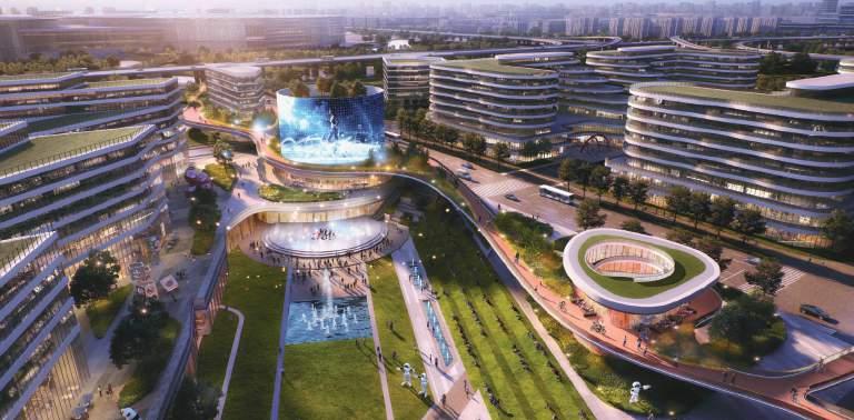
URBAN DESIGN OF WUSONG INNOVATION CITY TWO RIVESIDE CLUSTERS
地点:中国,上海
占地:14平方公里
主要职责:城市设计、结构梳理、文本绘制、外部沟通
Location: Shanghai, China
Area: 14 K m2
Role: Urban Design, Draft Presentation Structure, Booklet, External Communication
三江互通 两岸互动 江城互透 刚柔互济
Interconnected Three Rivers
Interactive Shores
Integration of City and River
Harmony of Hardscape and Softscape Elements


未来城市转型 生态定位特点
项目实施特点
滨江区位特点
交通区位特点
目的地驱动力
项目特别挑战 Interactive Gateway of Shanghai: The City of Scientific and Technological Innovation
是港城景从冲突到和解的前景 是苏松喉吭之吴淞的互望生态前厅
是全线畅游,转工为城的更新样板
是两区牵手,互惠共赢的联创示范
是黄浦滨江岸线新龙首
是上海北部到达的互通新门户
是国际邮轮度假区向内陆延伸的新未来
两岸交互城市框架
The interactived of riverside urban design framework
江岸城交互城市设计
The interactived of River-Bank-City
人城景交互空间
The interactived of people with city & nature
"Interactive" Riverside Gateway "交互型"滨江门户
通过一种富有互动性的城市设计策略,我们致力于塑造一座滨水门户,它不仅增强了两岸的连通性, 还激发了人们之间的交流。设计着眼于滨水空间、城市生活以及人与自然景观的和谐共生,旨在营 造一个充满活力、开放且互相渗透的空间。它巧妙地融合了三条河流的特色,激发了两岸居民的积 极参与,促进了河流与城市生活的无缝融合,并在坚硬与柔韧之间找到了完美的平衡点。
Through an interactive urban design approach, we aim to create a riverside gateway that fosters connectivity and interaction between the two shores. With a focus on the riverside, the urban area, and the harmonization of people, city, and landscape, our design envisions a vibrant and permeable environment. It encourages engagement between the two banks, facilitates the integration of the river and the city, and balances hardscape and softscape elements.
滨水岸线进退有序,观景轴线渗透入城市,为城市空间增添了呼吸的空间。 两岸形成3 组主要的对景组团,其中中央绿轴是最为重要的景观视廊。
The waterfront shoreline is strategically designed to be winding, allowing scenic corridors to permeate the city, thus adding breathing space to the urban environment. Three main clusters form on both sides, with the central green axis being the most important scenic clusters.


Soft Edge
Hard Edge
CentralAxis
Retreat
Convergent


从“产区” 到“园区”
From industrial zones to green districts

从“望水” 到“亲水”
Embrace the river by being close to the water
到“非线性” 创享之城
从“线性”
Transform the linear waterfront into a non-linear one

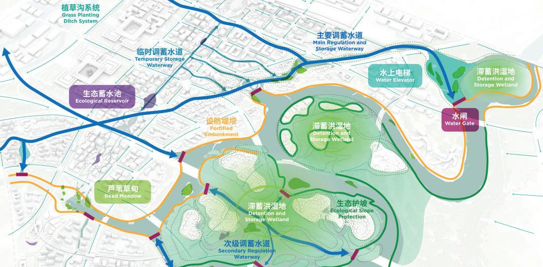
滋养之江:通过打造达江驿、江心岛、江上桥和江中渡,促进江岸水域的活力。在吴淞国际邮轮 港的带动下,形成两岸多层级水上交通网络。
润泽之岸:以进退有序的景观路径激活滨水岸线,并将观景轴线渗透入城。整合滨江五道三线, 包括两条连续的滨水跑步道,通往社区的连续漫步网,通往郊野与自然生态的探索路径等。
创享之城:
通过富含对景关系的地标体系和层叠渐进的滨江新城界面,来定义上海北门户的滨江 界面。采用三级天际线控制系统,水岸低强度开发,使建筑高度随滨水岸线向内逐渐升高,构成 了视野最优化的滨江界面。
Taking advantage of the characteristics of the harbor environment, transform the linear waterfront into a non-linear one, extending vibrant interfaces and enhancing the waterfront experience.
Urban theatricality
在繁华与生态交织的都市之中,九段式都市剧场以其独特的魅力呈现一场精彩绝伦的生活盛 宴。以创新的理念和前瞻性的规划,打造一个多功能、多元化的城市生活空间,满足居民的 各类需求,同时推动城市的可持续发展。
In a city where bustling urban life and ecology intertwine, the Nine-Section Urban Theater presents a captivating spectacle of vibrant living. With its unique charm, it creates a multifaceted and diverse urban space through innovative concepts and forward-thinking planning. This space not only meets the diverse needs of residents but also promotes the sustainable development of the city.


The interactived of people with city & nature
地点:利雅得,沙特阿拉伯
占地:456平方公里
主要职责:城市设计、结构梳理、文本绘制、外部沟通
Location: Riyadh, Saudi Arabia
Area: 456 K m2
Role: Urban Design, Draft Presentation Structure, Booklet, External Communication

打造一个独具利雅得特色的地方,多个生活方式社区设立在 一座自给自足的城市中,城市优先考虑与自然的连接、未来 生活类型和粮食安全。通过农业来建立城市的独特性格与功 能,并为循环经济提供框架
Creating a place that is distinctly Riyadh. A multitude of lifestyle communities that are set within a self-sufficient city that prioritises connection to nature, future living typologies and food security. Utilising agriculture to establish a unique character and function within the city and provide the framework for a circular economy.
“Net” City New mode of the suburban lifestyle "网状"城市 创城郊新生活
Climate adaptable strategies that maximises pedestrianisation
具有明确层级的功能 CENTRALIZED CITY
Function with a Clear Hierarchy
非农业导向 DEPENDENT CITY
Agriculture Excluded


The Net City
15-minute living circles define community districts and city quarters
A carbon-negative community with an agriculture focus

City Structure


基于广泛且灵活的连接性和可达性结构创建一座新城市。城市结构由关键主干道和节点定义,每个节点都有独特的特色。 Centres and Nodes

Creating a new city based on an expansive and flexiblestructure of connectivity and accessibility. A city strucutre defined by key spines and nodal points each with disctinctive character.
The City and The Ecology
Landscape Structure
Regional Access (Air, Rail & Car)

"15Minutes" Life Circle 生活圈


1. Enhanced Connectivity: Prioritising pedestrian pathways, cycling routes, and public transportation to foster a connected community that reduces reliance on cars and enhances accessibility to green spaces. Our plan includes a network of green corridors that connect people not just to places but to nature and each other.
2. Future Living Typologies: Implementing cutting-edge architectural designs and smart technologies that adapt to both current and future living needs, emphasising flexibility, efficiency, and sustainability.
3. Integration of Agrarian Landscapes: Designing urban spaces that seamlessly integrate agricultural areas, enabling not only local food production but also educational and recreational opportunities centred around agronomy.
4. Circular Economy Framework: Developing systems for waste reduction, resource recycling, and energy efficiency to create a self-sustaining urban environment that supports both the city and its natural surroundings.
Through this masterplan, Riyadh will transform into a city that not only meets the needs of its current residents but also sets a global benchmark for future urban living. By fostering a harmonious relationship between urban development and the natural environment, the Northeast Riyadh Masterplan will serve as a beacon of innovation and sustainability in the heart of Saudi Arabia.

“A masterplan designed to integrate sustainable living and advanced agricultural practices into a rich urban fabric, focusing on connectivity, community, and longterm ecological resilience.”


Natural Reserve
Wadi District | Centre North


FoodManufacturing
High-techFarming

“From farm to fork.” “从农场到餐盘。”


AlleyCourtyard Street Squares

AlleyCourtyard Street Squares


AlleyCourtyard Squares WADI
Street - Alley - Square
“以利雅得的古城格局为基础, 用现代的建筑组团塑造传统文化记忆。”

Alley Street Squares
WADI
“Informed by the urban patterns of historic Riyadh creating the memory of a traditional vernacular expressed with contemporary typologies.”

Squares
Street


At-Turaif Old Riyadh
Old Alley
地点:

一条沿申长路微循环巴士线路 两组地下车行环线
三组空中骑行廊桥
Hongqiao HuJie 虹桥互界
在公私共赢模式下,
通过强大的开发合作伙伴的持续努力, 以强支撑的政策引导、
强辨识度的品牌创建、
强话题感的场所营造、
结合高弹性的混合功能、 高品质的景观设计,
打造出与未来接轨的营商环境, 重塑出极富创造力的流量引擎, 推动项目的永续发展。
In a public-private win-win model, through the sustained efforts of robust development partners, with strong policy guidance, distinct brand establishment, creation of distinctive venues with strong themes, combined with high flexibility in mixed functions, high-quality landscape design, we aim to create a commercial environment aligned with the future, reinvent an immensely creative Commercial Flow Absorber, catalyzing the perpetual progression of the project.
场所营造
最初以房地产为主导的开发并不顺利
The initial development led by real estate was not smooth
从地理位置上看,道克兰靠近伦敦市中心,当地的交通规划在1970年代末已制定,但 实施受交通财政预算制约迟迟没有开展,导致道克兰地区与伦敦中心区隔离,通勤交 通十分不便。1990年代经济形势变差,商业办公空间需求减少,道克兰更是由于其交 通制约导致被市场抛弃。为此, 完善该区域交通系统成了区域复兴的必要条件。
From a geographical perspective, Docklands is close to the center of London. Local transportation planning was formulated in the late 1970s, but implementation was delayed due to budget constraints in the transportation sector. This delay resulted in the isolation of the Docklands area from central London, making commuting extremely inconvenient. In the 1990s, the economic situation worsened, and the demand for commercial office space decreased. Docklands, particularly due to its transportation constraints, was abandoned by the market. Therefore, improving the transportation system in the area became a necessary condition for regional revitalization.
吸引企业入驻,刺激经济增长 A refined transportation system, attracting businesses to settle and stimulating economic growth.

引入Jubilee线后快速增长
Rapid growth after the introduction of Jubilee line
区域内先增设了全长12.5km的轻轨(DLR),并与伦敦 城市轨道交通形成网络体系。直到在2000年修建了朱比 利(Jubilee)地铁线,加强与伦敦市中心及其他地区的 联系,才得以真正激活整个社区。
Initially, a 12.5km-long DLR was added, forming a network system with London's urban rail transit. It wasn't until the construction of the Jubilee subway line in 2000, strengthening connections with the center of London and other areas, that the entire community was truly revitalized.
CANARY WHARF 金丝雀码头
19世纪初到19世纪中期是繁华的海上贸易港口,带动英国造船业的高速增长
From the early 19th century to the mid-19th century, Dockland was a prosperous maritime trade port, driving the rapid growth of the British shipbuilding industry.
19世纪60年代,随着船舶工业大型化的发展,伦敦港的码头逐渐衰落
In 1960, as the demand for the large-scale shipping industry, the docks in the Port of London are gradually declining.
第一次城市更新政府和大伦敦议会(GLC)仍然定义港区为工业区,发展港口产业导致了更新的失败
In the 1970s, the government and the Greater London Council (GLC) still classified the dock area as an industrial zone and developed the port industry. This led to the failure of the first regeneration.
1980.政府成立半官方性质的伦敦道克兰发展公司(LDDC),负责道克
兰地区的城市更新。
The LDDC is a quango angency set up by UK Government (1981) to take charge of urban renewal in the Docklands area.
注重基础设施建设
• 规划联通该地区的机动车路线和轻 轨运输路线来解决该地区的孤立问 题,隧道高效联通两岸,激活沿途
小港更新。
Prioritizing infrastructure development.
• Connect the area with roads and rail transport to address its isolation issues. The tunnel efficiently links both banks and activates areas along the way.
1985年前,伦敦经融城建筑限制高度,激增的国际 企业迫切的需要办公场所,而靠近金融区的港区成为 了理想的选择地点。
The demand for office space in London was sharp increased
便捷高效的区域交通
引入了道克兰轻轨、朱比利、
伊丽莎白等3条轨道交通和莱姆豪斯、布莱
克沃尔和罗瑟希斯隧道
Constructed DLR, Jubilee, and Elizabeth Line; as well as Limehouse, Blackwall, and Rotherhithe tunnels.
• 道克兰轻轨以相对较低的成本打破地区割 裂。
• 朱比利大运量轨道交通补足客运能力不足短 板。
• 伊丽莎白线全域化通勤辐射半径,增加人力 资源储备。
Efficient and convenient regional transportation.
• DLR breaking regional barriers at a relatively low cost.
• JBL as high-capacity rail transit supplements the capacity.
• Elizabeth Line Expanding the commuting radius enhances human resource reserves.
设立有 引导性的产业 扶持政策
• 免征地方税,不征收开发土地税,工业 建筑给予100%的资本补贴等税收减 免政策。
The demand for office space in London was sharp increased
与时俱进的更新策略
• 引进高校,增加人力储配,丰富客群种 类跟随时代趋势,创建技术创业公司 孵化器Level39,为初创企业提供适宜 的环境。
高混合的建筑功能
• 码头有531,000 sq ft的办公, 826,000 sq ft的住宅,和55,000 sq ft的零售。
• 码头拥有超过20%占地面积的广 场、人行道和园景公园,都为游客 和上班族提供了宁静的休憩场所。
Establishing industrial supporting policies.
• The relief measures including no development land tax imposed, providing 100% capital subsidy for new commercial and industrial buildings to offset corporate and income taxes.
Progressive renewal strategies.
• The university increases the talent pool and diversifies the customer cluster in line with trends. Establishing a technology incubator, 'Level39,' to provide a conducive environment for startups.
Mixed-use building.
• The wharf features 531,000 sq ft of office space, 826,000 sq ft of residential space, and 55,000 sq ft of retail.
• Over 20% of its land area dedicated to squares, sidewalks, and landscaped parks, providing tranquil resting spaces for visitors and office workers.
快慢分层,人车分流。
fast and slow stratification, separation of people and vehicles.

高空间:空中层(5到10米) Upper levels (5-10m)
空中骑行廊桥
SKY CYCLING BRIDGES
骑行+ 运动倾向人群
Cyclists and sport enthusiasts

Attach
中空间:地面层(0米) Ground Floor (0m)
地面慢行空间
GROUND LEVEL PEDESTRIAN SPACE
慢速步行+ 响应式公交+ 景观倾向人群
Strolling and responsive public transit


低空间:地下浅层(-7.5米) Shallow Underground (-7.5m)
地下快行通道
UNDERGROUND RAPID TRANSIT
快速步行+ 中高速公交+ 商务/ 购物倾向人群
Fast walking, mid-to-high-speed public transit, and catering to business users


Sky Bridge
地下深层(-10米以下)
Lower Underground (below -10m)
地下车行环线
UNDERGROUND VEHICULAR LOOPS
车行+时间敏感人群
Vehicular traffic+ time sensitive population


Typical block regeneration of eight types of plots in three types of functions
模块化定制空中骑行植物园
Sky corridors create unique experiences and increase connectivity

Break the barriers of space 商业更新 Commercial
策展式体验的灰空间改造

办公改公寓 Transfer Office to Residential 三类功能八种地块典型街区改造
打造艺术与景观融合的空中门户节点
The landscape of the bridge node increases the sense of gateway node

富有惊喜感的入口空间
Create a attractive entrance and multi-levels accessible

打开首层空间,有温度的更新
Ground floor as commercial and social infrastructures

Enhance the three-dimensional space and boost community vitality

增加挑檐结构提供高品质阳台
Optimize the overhang structure to create an ecological garden apartment

通过内庭和屋顶优化提供社区空间
Optimize the inner courtyard space and activate community functions


生态长廊商水人文
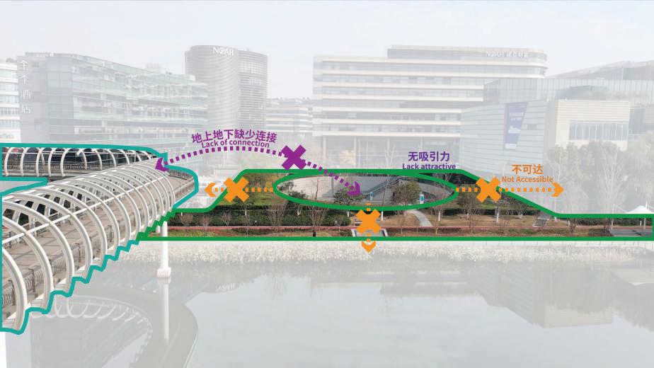
The eco-corridor, vibrant waterfront, and cultural aspects of the Hongqiao business centre 空间慢行系统不连贯,视线也被景观和建筑阻碍不连续
虹桥滨水空间 HONGQIAO WATERFRONT

如何营造一个适用适配适建的滨水空间? FUNCTION 如何打造一个可达可见可识的滨水空间? ACCESSIBILITY
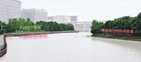
滨水空间和功能过于扁平,缺少与周边产生互动的功能和服务设施
如何塑造一个宜居宜城宜游的滨水空间? LANDSCAPE
HOMOGENEOUS 会展中心进入商务区的 第一印象
The first impression zone for entering the business district from the convention centre

华宇盛景

邻里雅集
国际都邑风貌之端
可达 Reachable 可见 Visible 可识 Recognizable Revitalize the image of International City 适用 Applicable 适配 Adaptable

文体风华延展之域 Serve the surrounding residential community
Ecological conservation 适建 Buildable
Livable

Tourist-friendly
滨水空间设计


兼具交通功能的地标构筑物 视觉引导性小品 视线焦点处提升 两岸错位开发

滨水空间设计
CIRCULATION
缝合断裂流线
板块整理缝合
绿荫穿梭游览动线
快慢分离多种步道
特色体验划船游线


【可识可感的滨水空间】 Recognizable and experiential


【可识可感的滨水空间】
Recognizable and experiential


ACTIVITY
活力体育滨江 DYNAMICSPORTS
静 TRANQUILITY
野趣生态公园 WILDNATUREECOLOGICAL
适配
有限空间无限活力 Limitedspace,unlimitedvitality 发挥现有公园优势 Leveragetheadvantagesofexistingparks
以静衬动 动静相衬托 THE INTERPLAY OF “ACTIVITY” AND “TRANQUILITY”
立交亲水绿湾 INTERCHANGEGREENBAY 居民休闲长滩 RESIDENTIAL LEISURE
WATERFRONTTHEATERSTATION "H"轴交点汇聚人气 Highwaytrafficflowonintersectionpointof"H" structure
桥下空间形成绿核 Under-bridgespaceforming agreencore


缤纷虹桥水岸:以虹桥为窗口,赏水岸缤纷
立交湿地绿湾:以绿湾为课堂,鉴自然力量
活力体育滨江:以运动为纽带,系邻里一心
野趣生态公园:以生态为媒介,得万物滋养


WATERFRONT AREA

采取经济高效的方法,尽可能保留现有设施和资源的使用 连接当前存在的断点,形成连贯的网络,提高整体的连通性 增加地标性建筑和艺术设施,提升区域的文化和视觉吸引力 增加多功能空间和活动设施,丰富区域的功能性

宜居
WATERFRONT ON WEEKDAYS
虹桥滨水可以举行社群活动、安全地玩桨板、尾波冲浪和索 道划水,为平静的滨水空间在平日里增添一些生活的乐趣。


滨水空间设计 WATERFRONT AREA
缤纷水岸 DYNAMIC RIVERBANK 宜城 CITY-FRIENDLY
进退岸线
亲水软质草岸 活力硬质广场
Winding shoreline
Hydrophilic soft grass bank Vibrant hardscape square
滨水空间设计 WATERFRONT AREA
缤纷水岸
DYNAMIC RIVERBANK


滨水空间设计 WATERFRONT AREA
SPECIES COORDINATE


虹桥滨水可以设置国际比赛标准的水上游乐赛道,以承载多
样滨水活动,完整了虹桥叙事中最磅礴的故事线。
将原先单调的硬质驳岸柔化设计,利用坡道消解高差,同时加强驳岸的洪涝适应性。
水岸码头


滨水空间设计 WATERFRONT
SPECIES COORDINATE


以静衬动

缤纷虹桥水岸:以虹桥为窗口,赏水岸缤纷
立交湿地绿湾:以绿湾为课堂,鉴自然力量
动静相衬托 THE INTERPLAY OF “ACTIVITY” & “TRANQUILITY”
活力体育滨江:以运动为纽带,系邻里一心
野趣生态公园:以生态为媒介,得万物滋养
桥下空间形成绿核 Under-bridgespaceforming agreencore
动ACTIVITY
虹桥江驿剧场 WATERFRONTTHEATERSTATION "H"轴交点汇聚人气 Highwaytrafficflowonintersectionpointof"H" structure
活力体育滨江 DYNAMICSPORTS
有限空间无限活力 Limitedspace,unlimitedvitality
WILDNATUREECOLOGICAL
Leveragetheadvantagesofexistingparks
动静结合服务周边客群
Integrate dynamic and static elements to serve the surrounding visitors.
Enhance the main entrance to create an international waterfront image.
Undertake nodal renovations at key visual focal points.
放大主入口打造国际化滨水形象 视线焦点处节点性改造 功能丰富激活水岸 尊重自然生态本底
Respect the natural ecological background. Enrich functions to activate the waterfront.
地点:
12.7方公里
主要职责:景观设计 、城市设计、结构梳理、文本绘制
产业规划协同度
Industry Synergetic 城市系统联结力
Urban System Connected
功能构型多元化
Functional Diversified
实施运营落地性
Operational Feasible
Location: Ningbo, China
Planning Area: 39.9 K m2
Design Area: 12.7 K m2
Role: Landscape Design, Urban Design, Draft Presentation Structure, Booklet
空铁时代,枢纽城市设计经历了由站城分离布设向站
The Era of Air-Rail Integration: The design of hub cities has evolved from separating stations and cities to integrating them interactively, incorporating threedimensional traffic flows and embedding humanoriented and ecological concepts. In the new era of Ningbo’s air-rail hub development, what should be the primary focus for advancing the hub?
To ensure optimal resource allocation, strengthen
城交互共融,流线立体辐射,人文景观嵌入等一系列迭 代提升。在宁波空铁枢纽建设的新纪元,什么才是枢纽 发展的首要任务? 为保证枢纽资源的最优配置,强化城市竞争力,提高未 来适应性,增进社会福祉普惠并保育文化,在人流物 流信息流集中的宁波枢纽,价值最大化成为我们设计 的核心目标。结合设计衍生顺序,我们将价值最大化 体现在产业规划协同度,城市系统联结力,功能构型 多元化,实施运营落地性四个层面。 urban competitiveness, enhance future adaptability, improve public welfare, and preserve cultural heritage, value maximization has become our core design objective at Ningbo Hub, where people, logistics, and information converge. Following the design development sequence, we express value maximization through four aspects: industry synergy, urban system connectivity, functional diversity, and operational feasibility.
Skyward Ningbo: Unified by air and rail
空铁发展过程中的设计迭代 Iterative development of air rail hub
站城分离 Separated city & station 1

3 流线立体化 Vertical development

2 站城融合 Integrated city & station

4 站城人景文一体化 Integrated city, station, landscape & culture

城市系统联结力 Urban
功能构型多元化

AMBIENCE


城市设计通过空间构型、交通系统、城市产品和生态景观四个方面加强系统性构建和产业落地性支撑。
The scope of urban design strengthens systematic construction and industrial landing support through four aspects: spatial configuration, transportation system, urban products, and ecological landscape.
六大融合中心
Six Integration Centres


Government


One core connected with three corridors, and the islands merge into a network.

ToAir-RailHUB
FromWaterTown
以水代城,一个渐进式的发展过程。
水脉从南边的分散到逐渐在北边汇聚。
Water as the foundation of the city represents a gradual development process. Water flows from the dispersed southern areas, gradually converging in the north.
FloodWay 地势高点 High Elevation Area 排涝通道 FloodWay
Landscape Node
Landscape Node
根系水系
Water Body


Landscape Node
“Comb” Shape Water Body
碳未来半岛
湿地公园 Carbon Future Wetland 景观
户外运动俱乐部 Outdoor activity Club
Landscape Node 南三江口 生态核 South Sanjiangkou Eco Core 生态岛 Natural Island
园林式度假酒店 Resort Hotel
碳知乐园 Education Park
栖居水镇中心 Water Town Centre
冥想岛 Meditation Island
湿地探索乐园 Wetland discovery park
游客中心 Tourism Reception 科技田园 High-tech Field
+2.38m
The northern side of the river primarily features Seasonal Water Retention Channels for rapid drainage. The southern side are barrages, slopes, and wetlands, that balancing development and the retention of floodwater.
户外拓展园 Outdoor Activity
i do r
枯水期呈现潜水湿地,维系水系调节作用。
During dry periods, the area presents as a subsurface wetland, maintaining the regulatory function of the water system.
河道 River 可淹没区 Floodable Zone


+2.38m +3.2m
丰水期,雨水经南塘河等水系直排奉化江。通过修 建生态护坡,促进雨水下渗快排,缓解城市内涝。
During the wet season, rainwater is directly discharged into Fenghua River through water systems such as Nantang River. By constructing ecological slopes, we can promote rapid infiltration of rainwater and alleviate urban flooding.

枯水季 Dry Period 丰水季 Wet Period

+2.38m
暴雨期,水位快速上涨,部分湿地,林地被淹没, 形成各类生态浮岛,强化拦截入湖污染物, 水质提升等作用。
During heavy rainfall, water levels rise rapidly, submerging some wetlands and forests, which create various ecological islands. These islands help intercept pollutants and improve water quality.


暴雨季 Storm Period
Diversified Waterfront Space
度假社区 Vacation Community
特色民宿 Featured Airbnb
社区中心 Community Centre

栖居水镇 Water Town
帆船俱乐部 Kayak Club

碳未来半岛飞行公园 Future Peninsula Flying Park
激活半岛中心活力空间
Activatethevibrantspaceatthe centerofthepeninsula
地势高点聚合成岛 Thehighpointsoftheterrain aggregateintoislands
利用场地原有水系的有机形态,组团聚落最大化视野
价值,体现独有江南文化气质。

Laneways
潮流前滩
Trendy Waterfront
梳状水系和里坊式街区 Combshapedwatersystemand neighborhoodstyleblocks
沿袭了南塘河的传统围合肌理,用现代手法穿插多样

站城融合中心
City and station integration centre
政企融合中心
Government and enterprise integration centre
展贸融合中心
Convention and enterprise integration centre
低空融合中心
Low-altitude integration centre
物联融合中心
产城融合中心
Industry and city intetration centre

贸易供应链智慧服务平台
医工融合产业中心
数字健康大数据中心
站前新天地
国际健康城
国际医美城
进口商品嘉年华
艺术交易中心
小微艺展馆群
水岸公寓
专业服务总部
龙头企业总部
平台公司总部
人才服务公寓
资质认证中心
国际数贸论坛永久会址
国际展贸街区 展贸公寓
低空总部第二集群
低空服务业集群
低空经济调度中心
低空人才培训中心
青年人才社区
核心组件研发中心
低空基建研发中心
科学家独栋别墅
智能感知产业园
智联平台数字园
设计范围 :50平方米
主要职责:主创设计师
项目状态:阶段性完工

Location: London, UK
Design Area: 50 m2
Role: Main Deisgner
Status: Phased Construction
“The deceased of the great person makes London’s rainy weather mixed with some sorrows. A drop of rain, insignificant yet able to bloom such a ravishing ripple. Dripping of rain droplets composed a hymn that worships the great persons, just like how their spirits are remembered and sung.” “伟人的离世为伦敦连绵的细雨增添了一抹哀 思。一滴水珠,虽微小,却能激荡出迷人的波纹。
雨滴的轻敲,汇成了一曲颂扬伟人的赞歌,仿佛 他们不朽的精神,被永恒地铭记与颂扬。”

Formation of ripples on water surfaces symbolized how thought creates influenc
Numerous inverse cones, formation of various thoughts, ripples on the water surface symbolized the collision of different thought

Cones come in different sizes shows the variability and dissimilarity of thoughts


Reflective materials enable the students of LSE to reflect and feel sentiment during the process of enriching.
Numerous inverse cones, formation of various thoughts, ripples on the water surface symbolized the collision of different thought Rainwater recycling system for
我们从伦敦连绵的细雨和涟漪效应中汲取灵感。一滴雨是渺小的, 但当无数雨滴汇聚,便能化作滂沱大雨。正如没有两滴完全相同的 雨水,每个人也都拥有独特的思想。当这些思想相互融合、碰撞,它 们便有能力去改变整个世界。

We are inspired by London’s wet weather and the ripple effect. A single rain droplet is unable to form precipitation, but countless drops can turn into torrential rain, changing people’s lives. Just like every drop of rain cannot be exactly identical, everyone has independent thoughts, but the combination and collision of these thoughts can change the world.

遗产花园是为缅怀已故的梅琳·伯尼博士(Dr. Mayling Birney)及伦敦政治经济学院(LSE) 的其他已故员工而建,由学院委托设立。这个花园旨在打造一个充满生机和活力的休憩之 地,它不仅是一个供人享受的绿色空间,更是学院对逝去同仁表示敬意、感激与缅怀的重 要场所。在这里,我们仿佛能与他们的灵魂进行超越时空的对话。同时,鉴于当地的气候条 件,我们期望遗产花园能够融入雨水回收系统,为实现一个可持续的未来贡献一份力量。
The Legacy Garden is for memory Dr. Mayling Birney and LSE staff who have passed away, commissioned by LSE( London School of Economics & Political Science). The aim of the legacy garden is a living, breathing space that invites people to utilize it. By putting a spotlight on their generosity, we hope it serves not only as a place of ornamental value, but as a focal point by which the school openly honors, thanks, and remembers its legators. Also, a place where we can communicate with them spiritually and honor their unique perspectives. Considering local weather patterns, we fervently hope it will be part of the rainwater recycling system for a sustainable future.
Chorus of Ripples 涟漪交响
英国伦敦政治经济学院遗产花园“涟漪交响”LSE LEGACY GARDEN “CHORUS OF RIPPLES”
“在这里,通过镜面的多角度反射,你可以从不同的视角观察世 界和自我,体验一种全新的认知之旅。”
“Through the refraction of mirrors from different angles, you will see the world and yourself from different perspectives. This is a process of seeing yourself and exploring the world clearly.”


那些圆锥体代表着先贤的智慧,它们让我们得以在此刻审视自我,就如同我们站在巨 人的肩膀上,远眺这个世界。当人们行走在小径之中,他们仿佛被先驱者的思想环绕, 不断地从中获得启发。
Those cones symbolize the wisdom of the legators, and through them, we see ourselves now, as if we are standing on the shoulders of giants and looking at the world. When people are walking in the middle of the path, they are like being surrounded by the thoughts of pioneers, getting inspired from them.


伦敦,这座细雨绵绵的城市,常常沐浴在阵雨 之中。我们希望屋顶花园中的这个装置能够 体现可持续发展的理念。该设计方案计划建 立一个雨水回收系统,利用圆锥体来过滤和 收集雨水。在屋顶花园下方设置的雨水蓄水 池,将用于满足学校绿化的灌溉需求。
London is a rainy city with frequent showery weather. As an installation located on the rooftop garden, we hope to endow it with the idea of sustainable development. The design of the project intends to construct a rainwater recycling system with cones serving the purpose of rainwater filtering and gathering. Rainwater Cistern will be placed beneath the rooftop garden to achieve the requirement of flora irrigation in the school.


Hydrology Simulation


Solar Simulation
Existing


Wind Simulation
Summer Winter

Purpose: Achieve thermal variation for student and staff; Warm (lef t) V.S. Cool (right)
Purpose: Achieve thermal variation for student and staff; Warm(left) & Cool (right)
Vertical shading device 60 degree

Issue: No shading and cooling effect to cool down the staircase space (right).
Horizontal shading 0 degree

Issue: A mild shading and cooling effect
Issue: A mild shading and cooling effect to cool down the staircase space (right).
Horizontal shading 30 degree

Ground Level Ground Level Level 2 Level 2


The entrance space has low wind speed in summer and moderate wind speed in winter
Process 2


Create a triangle prism to direct wind from south to the entrance space to cool down the space in summer and block the wind to reduce wind speed in winter
Process 3


Stretch the right cornor of the shape lower to direct more wind from south
Existing Outcome


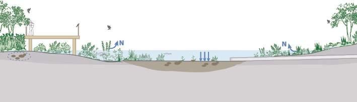
Wetland Bio Purification System

Wetland vegetation inhibits the release of de

Vegetation provides a surface for biofilms plus contribute carbon and oxygen to the soils, providing conditions that promote nitrificationdenitrification, leading to nitrogen removal
Through pipe to Inlet Pool
Slowing of run off increases sediment deposition rate
Water run of, carrying sediment particles (coarse and fine) and dissolved pollutants (nutrients and pesticides

Deposition of coarse ( and medium sized) sediment particles

李庄片区总体策划和城市设计 URBAN DESIGN OF YIBIN LIZHUANG AREA
地点:宜宾,中国
占地:5.53平方公里
主要职责:城市设计、结构梳理、文本绘制 、外部沟通

Location: Yibin City, China
Area: 5.53 K m2
Role: Urban Design, Draft Presentation Structure, Booklet
At the beginning of the Yangtze River, there is a sacred land that integrates diverse beauty, making it an ideal place for recreation. It is Lizhuang, Yibin. As a nurturing place of national spirit, witnessing many turning points of traditional culture. During the war time, plenty talents and scholars settled here enjoying beautiful nature and the poetry and wine, which contributed the cultural foundation of new China. It makes Li Zhuang more colourful.
Ten cultural elements are melted into the space, creating six new scenes of Li Zhuang.The water at the source of the Yangtze River is the source of Lizhuang. Based on the rolling mountains, the urban space will be constructed with interlocking corridors in the process of tracing the cultural veins. It is a Scenic City with profound culture and also a River City of traveling and healing, signifies the concept of integrating erudition, charm, culture and health care.
博雅文庄 游养江州
A scenic city with profound culture and also a river city for traveling and healing
在万里长江源头,蕴藏着一方圣土,融汇万象精魂,乃为康养的理 想之地,此处,便为宜宾之李庄。作为民族精神的涵养地,传统文化 的转折点。在草木山川与诗酒年华里,抗战年代诸多文人雅士在此 沉淀,奠定了新中华的文化根基,为李庄加上了一笔璀璨的色彩。

彼十大文化要素,溶于空间之中,创生出李庄六大新盛景。长江源 头之水,乃李庄生命的源泉,以起伏的丘陵山脉为依托。在追寻文 化脉络的过程中,勾住了廊坊交错、曲径通幽的城市空间。博雅文 庄,游养江州。寓意着集博学、雅趣、文化及养生于一体的理念。


Timeless Ancient Town Scholarliness River & Upland Topo


滨江景观将各个文坊节点有机地串联在一起,形成了一个连续的、整体的景观带。
临山区域采用梯田式布局,因地制宜地融入山体,形成具有林盘田园风光 的院落,实现建筑与自然环境的和谐共存,提升居民宜居体验。
中间发展带采用纵横交错的古韵街巷布局,将各类空间有机串联,保留传统特 色,融入现代城市空间,形成多元开放且具有李庄文化气息的空间体系。
在基地的建筑形态方面,我们将古典李庄风韵向东延续,恢弘古朴的建筑风格与山水本底相得益彰。
在保留古镇建筑肌理的同时,充分利用了当地得天独厚的地理 条件,形成了独具特色的有机田园式院落, 以梯田式布局呼应 临山的地形,形成了错落有致的建筑群落。 建筑肌理与道路网 相契合,进一步强化了古镇、公共服务空间和社群之间的联系 与衔接。
While preserving the architectural texture of the ancient town and leveraging the unique local geographical advantages, we aim to create a distinctive urban fabric.
The harmoniously scattered architectural clusters will follow a terraced layout inspired by the topography of the nearby mountains. The building footprint integrates with the road network, further enhancing the connection between the ancient town, public service spaces, and the community.


地点:
主要职责:城市设计、结构梳理、文本绘制
URBAN DESIGN OF THE BAISHA RIVER ‘ONE RIVER, TWO BANKS’ INTERNATIONAL DEVELOPMENT
Location: Qingdao, China
Area: 11.5 K m2
Role: Urban Design, Draft Presentation Structure, Booklet

该设计充分考虑了青岛城阳区的城市特色,这里是年轻人的聚集地,正值青岛产业升级和 白沙河沿岸城市更新带来的人才汇聚之际。设计目标是打造一个融合山海之美、优质城市 生活、创新湾区活力和社区活力的城市景观,旨在解决山海之间缺乏有效连接、自然景观特 色不够突出以及城市功能不完善等问题。白沙河沿岸的城市设计策略包括连接山海、彰显 自然之美、拥抱河流与水体、照亮整个城市,以期创造一个充满活力和创新的城市空间。

The design takes into account the urban backdrop of Qingdao Chengyang District, which is a gathering place for young people, coinciding with the opportunity for talent aggregation created by the industrial upgrading of Qingdao and the urban renewal along the banks of Baisha River. It aims to create an urban landscape that integrates mountains, seas, quality cities, innovative bays, and lively neighborhoods, addressing issues such as the lack of connectivity between mountains and seas, the indistinctiveness of natural landscapes, and the deficiency in urban functions. The urban design for the banks of Baisha River employs strategies such as connecting the mountains to the sea, highlighting the natural beauty, embracing the river and water, and illuminating the entire city. 青岛市白沙河“一河两岸”国际综合发展区
山海之间
引力白沙
Mountains to Sea: The Charms of Baisha River


塔楼 (酒店/ 办公/ 餐饮娱乐)
Tower (Hotel/Office/Dining & Entertainment)
三层 (餐饮娱乐)
Third Floor (Dining & Entertainment)
二层 (商业零售)
Second Floor (Commercial Retai)
一层 ( 商业零售 / 数字体验/ 艺
术长廊 / 演绎展销)
First Floor (Commercial Retai/ Digital Experience/Art Gallery)
地面层 (开发空间)
Ground Floor (Open Space)
地下 (连接流亭地铁站)
Basement (Connect to Metro station)

地下一层空间连接流亭地 铁站,打造出站及商场的 TOD氛围。
The underground firstfloor space connects to the Liuting subway station, creating a TOD atmosphere for exiting the station and entering the shopping mall.

站城人一体的TOD综合开发
Integrated TOD Comprehensive Development that Integrates Station, City, and People

站-共享的公共交通 城-互联互通的城市空间 人-宜人的生态居住生活环境
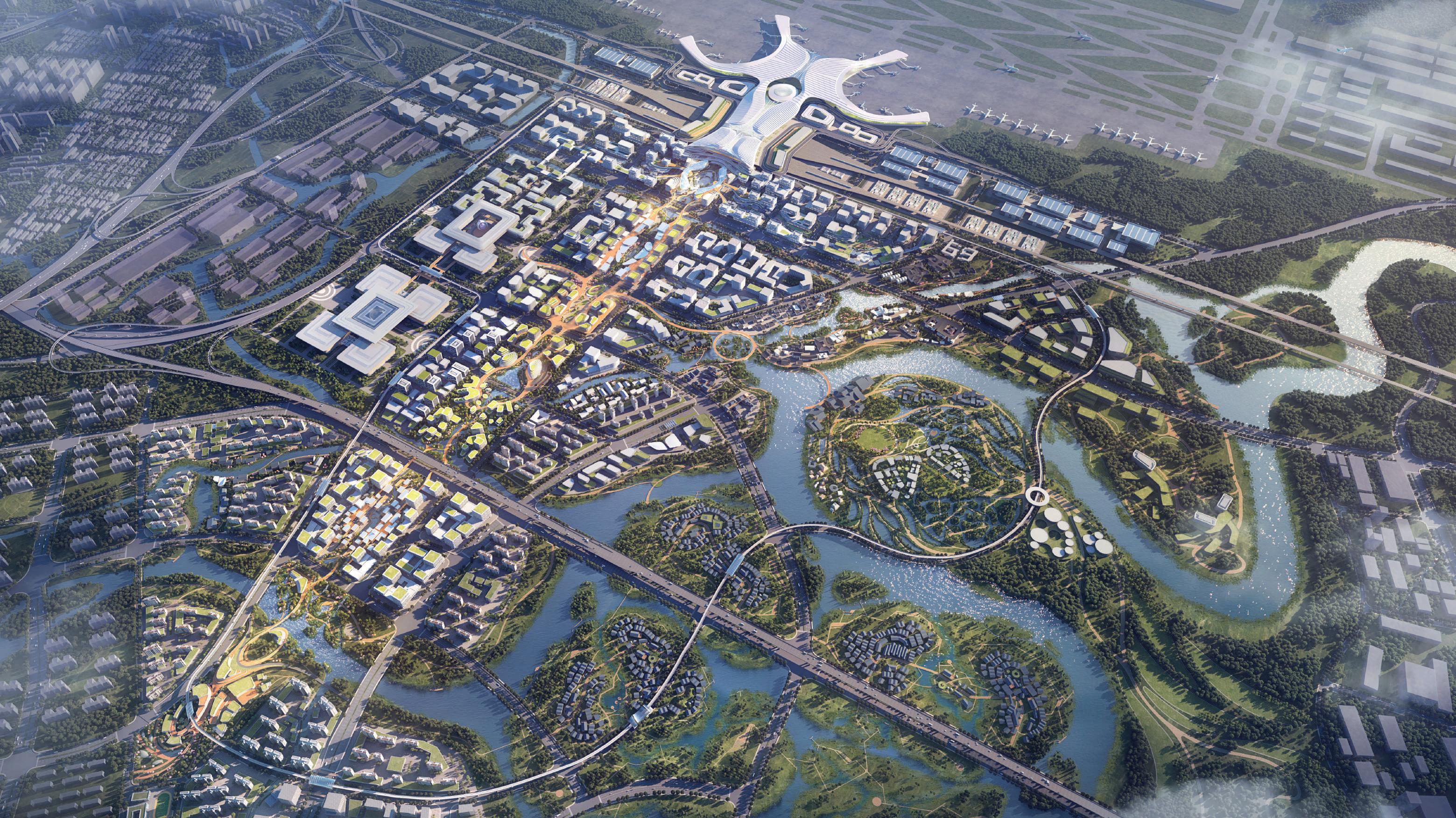
Location: Shanghai, China
Area: 3.16 K m2
Role: Booklet
FUNDATION

云祥江海 智汇四方

奉贤是上海五个新城发展规划轴上的重要节点。以“美丽”业
Fengxian is an important node on the axis of Shanghai’s five new cities development plan. With a focus on “beauty” industry, cluster is formed with related production agglomeration, attracting talents. Four visions are rised to upgrade the area:
1.An Open and Shared Technology and Innovation Transformation Highland.
2. An Inviting All-Day Vibrant Centre.
3. A new sustainable and liveable city with rich culture
4. A Natural and friendly smart hub with three-dimensional structure
CENTRALIZATION
生活空间多元化, 双轨功能精准定位 Diversified living space, precise positioning of dual track functions 依据产业研判,将五号线奉浦大道站定位为 商务休闲型TOD节点,市域铁路南枫线环城
“Serene clouds envelop the rivers and seas, uniting intelligence from all corners.”


Combining the communication and display functions within the block,Setting up interconnected sunken courtyards

1.实施综合规划与设计
资源要素之间的距离更近,更容易流动和互动。
2.建立共享经济平台
鼓励发展共享经济平台,通过技术和数字 化手段促进资源共享和互联。
3.建立示范项目和创新实验室
为与资源流动相关的创新思想和项目提供支持,建立示范项目 和创新实验室,并促进不同领域间的跨界合作与经验分享。
1. Establish integrated planning and design In urban design, it is necessary to consider the aggregation and layout of resources, so that the distance between various resource elements is closer and easier to flow and interact.
2. Create a sharing economy platform
Encourage the development of sharing economy platforms, promote resource sharing and interconnection through technological and digital means.
3. Establish demonstration projects and innovation laboratories
Provide support for innovative ideas and projects related to resource flow, establish demonstration projects and innovation laboratories, and promote cross cooperation and sharing of experiences in different fields.

多首层的院落空间
Courtyard space with multiple first floors