Portland to La La land
Regeneration of the Mumbai Port - People’s vision
STUDIO B + C
MA A + U
Heena Jameel Ahmed Shaikh
University ID: 21429764
MA Architecture + Urbanism | 2022 Manchester School of Architecture

Tutor: Curtis Martyn & Youcao Ren
MA Architecture + Urbanism
Manchester School of Architecture, UK
Copyright @2022
Manchester, United Kingdom
ALL RIGHTS RESERVED
Manchester School of Architecture


Copyright reserved by Heena Jameel Ahmed Shaikh
MA Architecture and Urbanism
1
I would like to extend my gratitude to all my tutors for their guidance and support. A very special thanks to Eamonn Canniffe who has mentored me throughout the journey and always been available for guidance. My Studio B tutor, Youcao Ren for guiding me in my research work and directing me towards progress each time.
A heartfelt thanks to Curtis Martyn, my tutor for Studio C. I thoroughly enjoyed our discussions about architecture in general and the public spaces in Manchester. The enthusiasm and rigour he shared for my project encouraged me to do better each time. A special mention to my family back home in Mumbai, my parents and siblings who have been nothing but encouraging and patient with me. Its their love and support that made me what I am today, capable of taking my own decisions. And lastly to my forever pillar, Sahil who is always by my side and proud of every step I take.. And finally to all my friends, the people who I met during my architectural journey in the past decade.
Special mention to Architect Rahul Kadri who helped shape my skills and confidence under his leadership, during my professional practice.
AND LASTLY THE CITY OF MUMBAI, MY FOREVER GUIDING FORCE…...
2
ACKNOWLEDGEMENT
In the saturated city of Mumbai, everyone is surviving for that extra inch of space. In such striving conditions having an available open space leads to hope for the inhabitants.
Every Urban development has three prime elements and voices involved. The government often aims at targeting the developers to develop open spaces into a commercially viable projects. On other hand we have the urban planners, trying to strike a balance between the economic and social aspects.

Today I aim to draw focus on the often neglected and the most feeble voice- ‘The People’.

Let’s assume it is the people who get to decide what they aspire to have on an available parcel of land. Let’s dedicate Portland to the ambitions and likes of the ‘Mumbaikars’. A space that every Mumbaikar can call their own.

ABSTRACT
STATE VISION
URBAN PLANNERS VISION
3
PEOPLE’S VISION
1. Site Introduction and Background 2. What does Mumbai need? 3. Who are the users? .1 Understanding the social hierarchy .2 Introduction to the users: Mumbaikars 4. In search of a breathing space .1 Analysing the Mumbai Coast .2 Activities on the Western Coast

5. Site Analysis .1 Present site images .2 History of the port .3 Neighbourhood locality .4 Transit Links .5 Current Land Use .6 Major Threats .7 Selected land parcel .8 Key components .9 Sections
6. Global Precedents
CONTENT- STUDIO B
25 30
4
7. Design Brief .1 Goals and Objectives .2 Programme .3 Schematic Zoning Acknowledgement Abstract 03 07 08 10 13
06

.1 Placemaking
.2 Derived
.3 Concept
9.
.1 Existing built
.2 Retained built
.3 Proposed circulation 10. Design
.1
.2 Key
.3 Design
.4 Master
.5 Site
.6
11. Key design elements 12. Transformation 13. Project
14.
15.
34 38 43 54 82 84 85 86 CONTENT- STUDIO C 5
8. Design Concept
diagram
city elements
sketches
Design Development
form
form
Proposal
Isometric development
Built masses
elements
plan
sections
Detail sections
timeline
Way forward
Bibliography
India

Maharashtra Mumbai
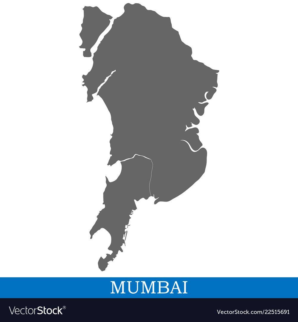

India, is a country in South Asia. It is the second-most populous country, and the most populous democracy in the world.


HISTORY OF BOMBAY

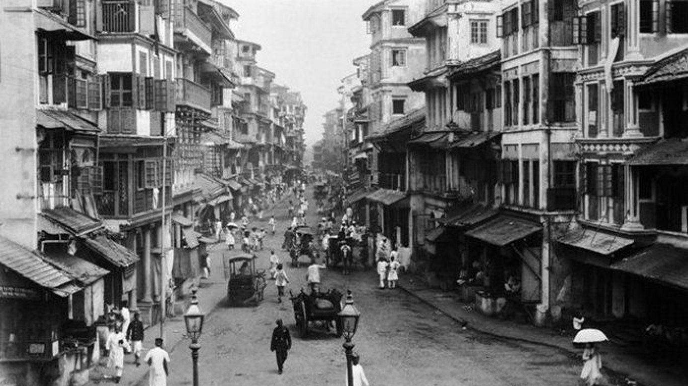

Portuguese Captured Islands of Bombay 1668
1534
FLASHBACK INTO BOMBAY
British Parliament ended East India Companies Commercial monopoly 1858 Bombay fell under direct British crown
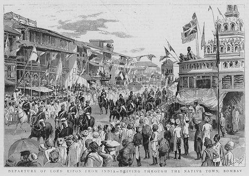
India gained Independence from Great Britain
1813
For centuries, the seven islands of Bombay were under the control of successive indigenous rulers before being ceded to the Portuguese Empire, and subsequently to the East India Company in 1661. The Kolis and Aagri (a Marathi fishing community) were the earliest known settlers of the islands.
1947 6

1. SITE
BACKGROUND
East India port purchased Port from Portuguese
2. WHAT DOES MUMBAI NEED?

● WITH 22 MILLION PEOPLE
● A HIGH POPULATION DENSITY
● SATURATION OF THE ISLAND CITY

● RESULTED IN LACK OF OPEN SPACE
● RECLAMATION ENDANGERS ECOLOGICAL BALANCE
Image ⓒ (Metro sky gardens, Mumbai, 2014)

Only6%ofthetotallandinthecityismadeupofOpenspaces. iscoveredby informalsettlements.
Most dominant growth pattern is driven by private owners landleft withoffices,shoppingmalls,gatedcommunities.
These trends compromise with health as well as democratic rights of Mumbaikars.

7
UNDERSTANDING THE SOCIAL HIERARCHY
‘
Wemustbeawareandupdatedaboutthe ground situations and underlying forces, the people, the culture, the social situations.Andthen,buildfromthere.’
20% of people in Mumbai are below the poverty line.


In 2016, an estimated 55 percent of Mumbai’s population lived in slums.


With an estimated 6.5 million people residing in these conditions, Mumbai has the largest slum population of any city in the world.

3.1
‘I AM NOT AGAINST DEVELOPMENT , BUT I AM SO IN FAVOUR OF UPLIFTMENT.’
8
Fig: Income group distribution map, Mumbai
3.2 INTRODUCTION TO THE USERS: MUMBAIKARS


Sawant the dabbawala

Ashok, Iqbal, Sabathe children
Vinod & Savita the senior citizens
Rahim, Meena the working class

Sunita the fisherwomen
Kamla the educated youth
Gopal- The roadside vendor

The Homemakers

9
4. In search of a breathing space for the city

10
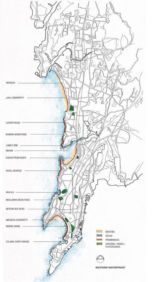
WESTERN WATERFRONT
Three types of waterfront areas: Public spaces, Native settlements and seaside heritage precincts.
Much-needed breathing space and the seascape in our choking city.
Has better mobility by means of the mass transit system.

Serves as an amalgam of cultures, heritage, architectural identity and land use.

EASTERN WATERFRONT
Less than 50% of the land used to its full potential.

30 kilometers of prime waterfront land is being locked up.
Physical access to all parts of the waterfront has been a restricted affair.


14.5 km of virtually inaccessible waterfront

●
●
●
●
●PUBLICMAGNET ●DEVELOPED ●WELLMAINTAINED ●EXHILARATING ●INTERACTIVE
● UNDER-UTILISED
IGNORED
INACCESSIBLE
MISTREATED
UNDERUTILIZED POTENTIAL
4.1 ANALYSING
ⓒ
11
THE MUMBAI COAST Image
(P.K.Das, n.d)
4.2 WESTERN COAST - PUBLIC ACTIVITIES
Public places in Mumbai, including beaches, gardens, promenades and tourist spots are all flanked along the West coast. Most of them are often revamped and maintained with addition of activities. During weekends and festivals, we often find them packed with people leaving very little scope of recreation or personal zone. The Western Promenade is a popular spot for various public activities such as jogging, walking, cycling, and picnicking. It offers scenic views of the Arabian Sea and the Marine Drive skyline. The promenade is an ideal spot for morning and evening walks, and it's a great place to experience the local culture and lifestyle of Mumbai. Along the promenade, there are street vendors selling various snacks and local food, as well as local shops selling souvenirs and other items.


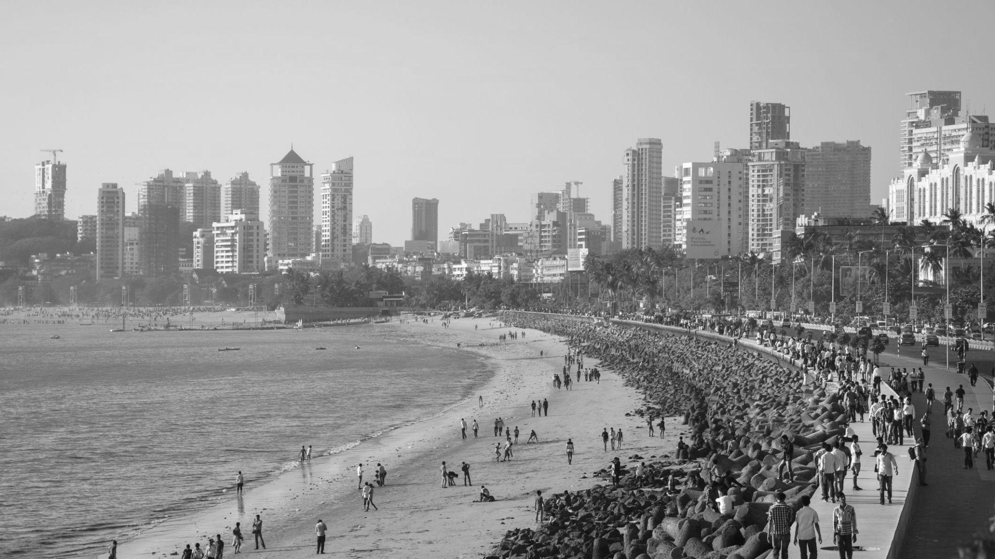
 Marine drive
Juhu Beach Carter Road Bandstand
Bandra fort
Worli Seaface
12
5. Analysing the Eastern Waterfront

13
5.1 SITE STUDY- PRESENT LAND USE IMAGE
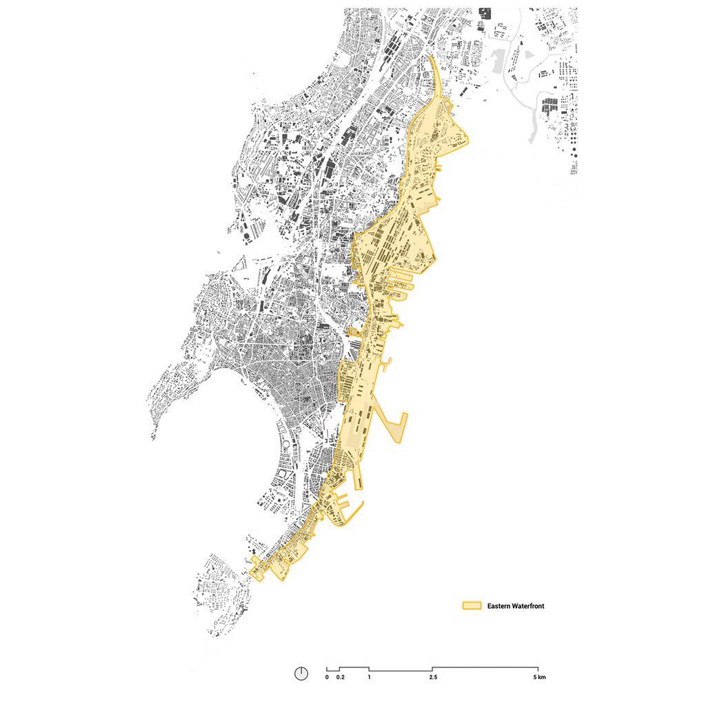
The Mumbai Port Trust area, spanning bout 10 kms, along the Eastern Waterfront is one of the best waterfront properties located in the heart of Mumbai city. Due to shifting of some port activities from to the new port across the bay, an area of about 500 Ha is available for redevelopment. Considering the extreme shortage of built space in the city, this underutilized land offers a great and historic opportunity to fulfil the demand for space. It would also give an impetus to the economy and provide the much needed social and recreational public amenities to the city. (UDRI, 2016)

Refineries
Present day site image Mangrove Refineries Warehouses Informal settlement Small scale industries Freeway Railway track
14
The Eastern Waterfront of Mumbai spans a length of about 30 km from Colaba in the south to Thane in the north. Within the island city, the waterfront area not only harbours the port activities of handling passenger and goods traffic, but also various defence uses, along with small- and large-scale industries.

SITE
USE
5.1
STUDY- PRESENT LAND
IMAGE Present day site image
Refineries Refineries Warehouses Informal settlement Refineries Small scale industries Freeway Railway track Informal settlement
Mangrove Fort Harbour link
15
5.2 HISTORY OF THE MUMBAI PORT


Development of the Portland Image ⓒ(Research & Design Cell, 2001)
SHIFT OF PORT ACTIVITIES–1989

Mumbai Harbour has been used by ships and boats for centuries. It was used by the Maratha Navy, as well as the British and Portuguese colonial navies.
In 1652, the Surat Council of the East India Company, realising the geographical advantage of the Port, urged its purchase from the Portuguese. The first of the present-day docks of the Port were builtinthe1870s.
MUMBAI- MANCHESTER OF THE EAST
The Promise of the Eastern Waterfront
With the shift of port activities to other technologically developed ports, few port operational activities remain within the 1800 acres of MbPT, thus opening up the opportunity to envision the use of the land forpublicpurposes.
Fig: 19th century Port, Bombay

16
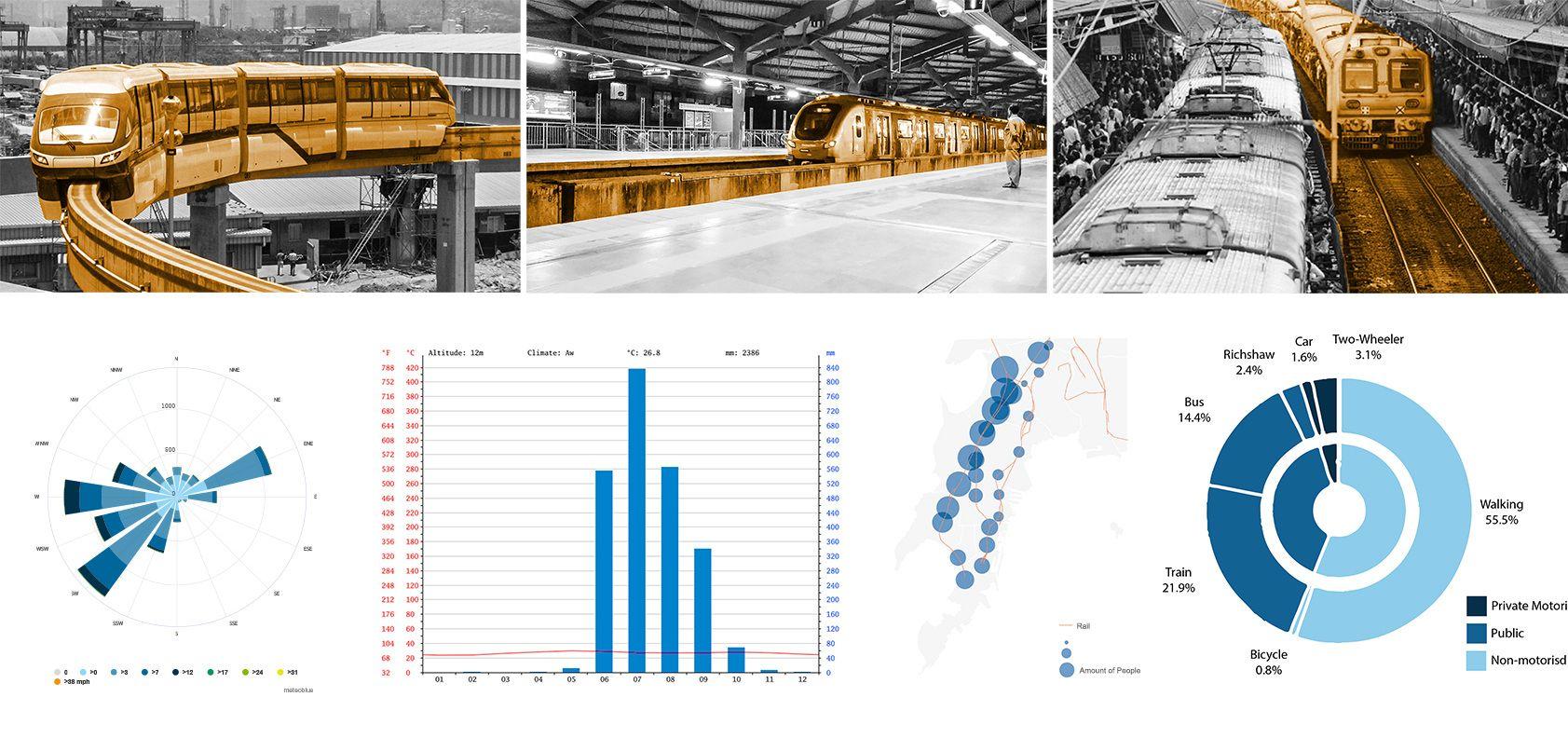
people compared to the east duetoitsdevelopment.



(Research & Design Cell, 2001)

Image ⓒ
Cotton green 17


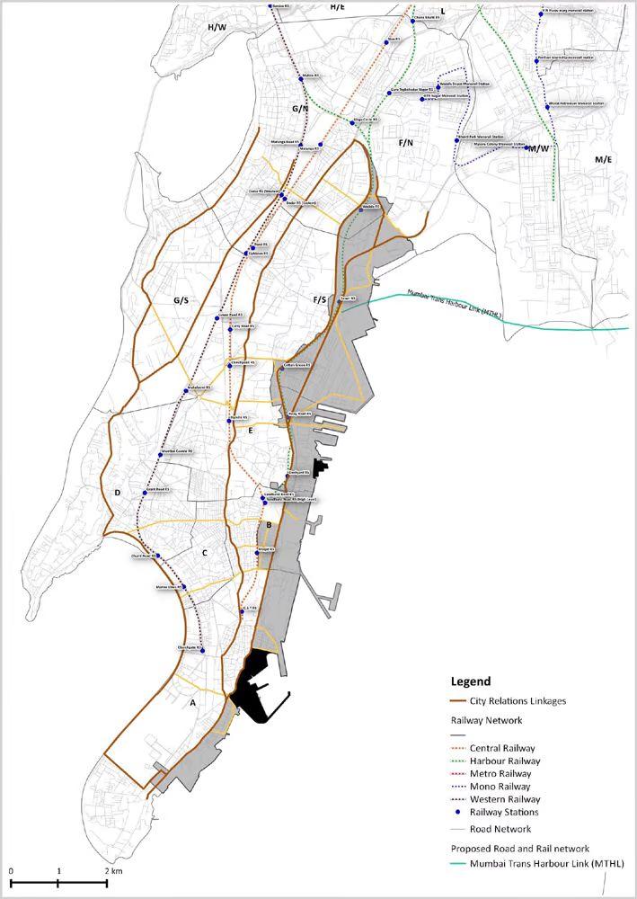
5.4 SITE ANALYSIS- TRANSIT LINKS Image ⓒ (Research & Design Cell, 2001)
EasternFreeway Railwayline
Portland Harbour link
Eastern Freeway
18
Sewri railway station


INFORMAL SETTLEMENT REFINERIES GOODS TRANSPORT WAREHOUSES INDUSTRIES SHIPBREAKING Port Activities: 187 Acres Residential: 30 Acres Storage: 284 Acres Industries: 406 Acres Defence: 82 Acres Small Industries: 78 Acres 5.5 SITE ANALYSIS- PRESENT LAND USE Image ⓒ UDRI, Mumbai 19


5.6 SITE
20
ANALYSIS- MAJOR THREATS
● Northern zone has the largest available land parcel.
● Atpresent,nodefenceorportactivitytakesplace from this zone, hence it is readily available for regeneration.

● The zone is well connected to all major transit facilities.


● The Sewri fort forms an interest to the Heritage aspectthatneedstobeemphasizedon.
● The presence of Mudflats and seasonal Flamingos make it of interest to the ecologists andeducationalists.
● The5kmslongpromenade tobedevelopedasa public zone, making it accessible to enjoy and rejuvenate.
● Thepresenceofthefishingcommunitydoeshelp me deal with the social upliftment of the entire community and making them a vital part of the wholeprogramme.
5.7
SELECTED SITE PARCEL
21



2 3 1 Jetty 22
Flamingo Viewing Deck


5.8 SITE CONTEXT- DECK & FORT PRECINCT
23
Sewri Fort


5.9 SITE ANALYSIS- SECTIONS Section 1-1 Section 3-3 1 2 3 4 Shrine Fort Housing Sea Storages Housing Refineries Industries Warehouses 24
6. Global Precedents

25
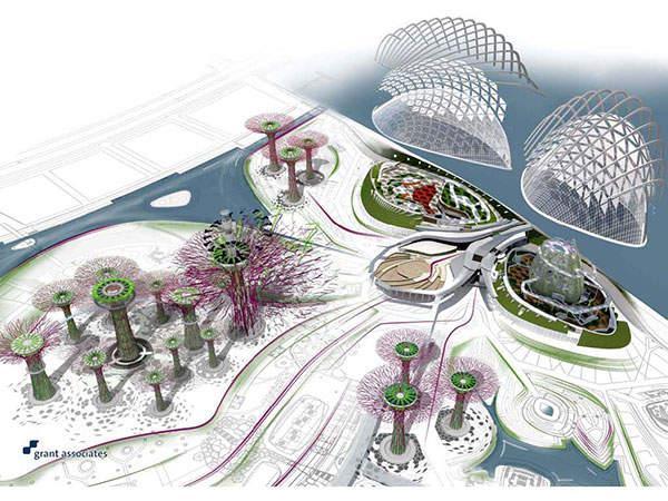
GARDENS BY THE BAY , SINGAPORE

● Architects:GrantAssociates
● Area:38 Hectares
● Year:2012
Gardens by the Bay is one of the largest garden projects of its kind in the world. Ultimately, the site will total 101 hectares comprising three distinct gardens – Bay South, Bay East and Bay Central. Located on reclaimed land in Singapore’s new downtown at Marina Bay, the site will provide a unique leisure destination for localandinternationalvisitors.


6.1 CASE STUDY 01- Global attraction 26
CASE STUDY - Waterfront Development

SHENZHEN BAO’S WATERFRONT CULTURAL PARK


● Architects:AUBECONCEPTION,SWA Group
● Area:38 Hectares
● Year:2020
Sitting within the central green axis of central Bao'an where the urban bustle meets the bay's tranquility, Shenzhen Bao'an Waterfront Cultural Park (the Park) integrates coastal leisure, cultural tourism, artistic experiences, and ecological workplaces to address the creation of "new urban coordinates of an international coastalcityandaworld-classbay-sidedestination".
6.2
27
6.3 CASE STUDY - Adaptive Reuse

SEVKABEL PORT, ST.PETERSBURG, RUSSIA
● Architects: AB Chvoya
● Area: 32,000 Sq.m
● Year: 2019
The Sevkabel PORT project is a process and represents the development perspective of the entire coastal industrial zone of this area. The former industrial site turns into a multifunctional cluster for everyoneandaplacewherethecitymeetsthesea.

The site is located in an industrial district with old red-brick 19th-century buildings of the Siemens & Halske manufactory coexist with and industrial facilities of the 70s of the 20th century on the same site. These buildings are located in different Coordinate grids of the brick and concrete buildings differ from each other, and that difference creates complex, trapezoidal spaces between them. Dealing with an existing environment, the focus is on the renovation and adaptation of existing buildings, as well as on the preservation of the industrial genius loci. This approach allowed to emphasize the existing features of the site, including some of the industrial artifacts.

28
CASE STUDY - Eco tourism
JUBAIL MANGROVE WALK, ABU DHABI, UAE
● Architects: Basis Architectural Bureau
● Area: 36 Acres
● Year: 2020
Jubail Mangrove Park is the first self-containededucational,natureandleisure destination of its kind in the Emirate of Abu Dhabi.


Aim is to enhance the awareness, appreciation and understanding of the important ecological function of the mangrovehabitats
There are three pathways to walk, the longest covers a distance of 2km and the shortestis1km.
The paths allow you to take a stroll through themangroves,explorethenaturallandscape andgowildlifespotting.
An information centre and viewing platform (forthoseperfectpictures)isalsoatthesite.
6.4
29
7. Derived design brief

30
7.1 DESIGN GOALS & OBJECTIVES
● To increase the open space per capita ratio for Mumbai to nearly triple from the present 1 square metre per person.
● Plan that aims to create non-barricaded, non-exclusive, non-elitist spaces that provide access to all citizens.
● To Ease pressure on the Western coast.
● Generate employment opportunities for the local inhabitants

HERITAGE PRESERVATION
Preserve the existing fort & revamp it to create a sense of security.
ECOLOGICAL AWARENESS
Educate and create awareness about the present ecology and its conservation.
RECREATION & LEISURE
A leisure pit stop for the working class providing a pause from the busy routine.
SOCIAL PLATFORM


A platform for all levels of the society to come together as one.
ART & CULTURE HUB
Promote the local culture and fishing community.
● Give back to the people of Mumbai.
● Generate employment opportunities for the community.

● Promote tourism thats helps improve revenue generation.
● Rearrange the landscape to synergise the key site components.
05 01 02 03 04 Peopleandtheir happiness Landscape and green Tourism Natural Coast Hope Equality
Energise 31
Joy
Heritage
Ecological Awareness
Arts & Culture
Social Activities
Leisure
7.2 DESIGN PROGRAMME
Conservation Provide information to the people
Mumbai,
and the establishment
01 ● Information center ● Restoration ● Ambientlighting ● Music&Light shows ● Landscaping
about
its rich history
of the fort precinct.
Creating awareness about the ecological imbalance, preserving what
and enriching
means to revitalise. 02 ● Ecotrail ● Flamingoviewing Deck ● Campingsight ● Sensorypark ● Broadwalk
is left
the same with
Boost and provide platform for the
community to get together and celebrate festivals, organise events 03 ● Artscenter ● Amphitheatre ● Fleamarkets ● Driveintheatre
local
Social platforms at various
and
environment
happier society. 04 ● Cafes, Restaurants ● Hawkers streets ● Outdoorsports ● FishingDeck ● Community garden Recreation &
Leisure
05 ● JoggingTrack ● Cyclingtrack ● MeditationDeck ● Children’sPark ● Seatings ● Waterfountains 32
hierarchy, help stimulate a healthy
friendly
thus leading to a
time is a must needed break from the all day routine, which refreshes one physically as well as mentally.
7.3
SCHEMATIC ZONING
Plan indicating pedestrian distances within site


Plan indicating proposed activity zones
All dimensions are in metres

33
STUDIO C

8. Design Concept 34


8.1 PLACEMAKING DIAGRAM 1. DIVERSE ACTIVITY ZONES 2. CITY MAGNET 3. BRINGING IN NATURE 4. INFILTRATION OF PEOPLE A PUBLIC PLACE 35
8.2 DESIGN ELEMENTS: Derived from the urban fabric


Streets Squares Overlooking Levels
Narrow scale streets lead to a buzzing activity zone along a natural movement.


Courtyards provide compact powerhouses for interaction, festivities and events.
Squares lead to larger plazas generating multiple activities in same zone
Levels provide visual connect thus a sense of community

36
Sketchviewofthestrategy
Sketchviewofthepromenade


8.3 DESIGN DEVELOPMENT- CONCEPT SKETCH
37
9. Design Development

38

9.1 Existing Built form Refineries Warehouses SiteArea-50hectares 1000x500mtsapprox Railway line Mangroves Harbour link Informal settlement Fort Mangroves Refineries Theformerindustrialsiteturnsintoa multifunctionalclusterforeveryoneandaplace wherethecitymeetsthesea. Freeway 39
9.2 Retained Built form
Mangroves Fort
Refineries
● Retaining the historic context of the site such that future generation is aware of what existed.
● Maximising site potential and natural context to create it as the key highlight
The site is located in an industrial district, in Mumbai. 19th-century buildings of the manufactory coexist with and industrial facilities of the 70s of the 20th century on the same site. Dealing with an existing environment, I focused my efforts on the renovation and adaptation of existing buildings, as well as on the preservation of the industrial genius loci. This approach allowed me to emphasize the existing features of the site, including some of the industrial artifacts.

40
Proposed Circulation
A green buffer of 35 mts width is created along the edge of the entire site to create an envelope that disconnects it with the surrounding sound and air pollution. Two access points are provided, one under the bridge and other from the Northern edge based on the planned functions within the siteandaconvenientaccessforpeoplenavigatingfromalldirections.

9.3
41
Residential neighbourhood
Informalsettlements
The site zoning is divide in several zones based on the activities derived from the programme. The existing context of the fort is to be restored into a heritage site along with adaptive reuse of the existing refineries. The cultural zone is planned towards the entry point making is accessible by large crowds during events. The Eco park is located on the secondary entry near the mangroves hence forming an integrated green leadingtoasereneandpeacefulenvironment.

9.4
gardenforll CulturalZone HeritageZone Adaptive Reuse Ecopark
Proposed Zoning ACommunity
42
10. Design Proposal

43
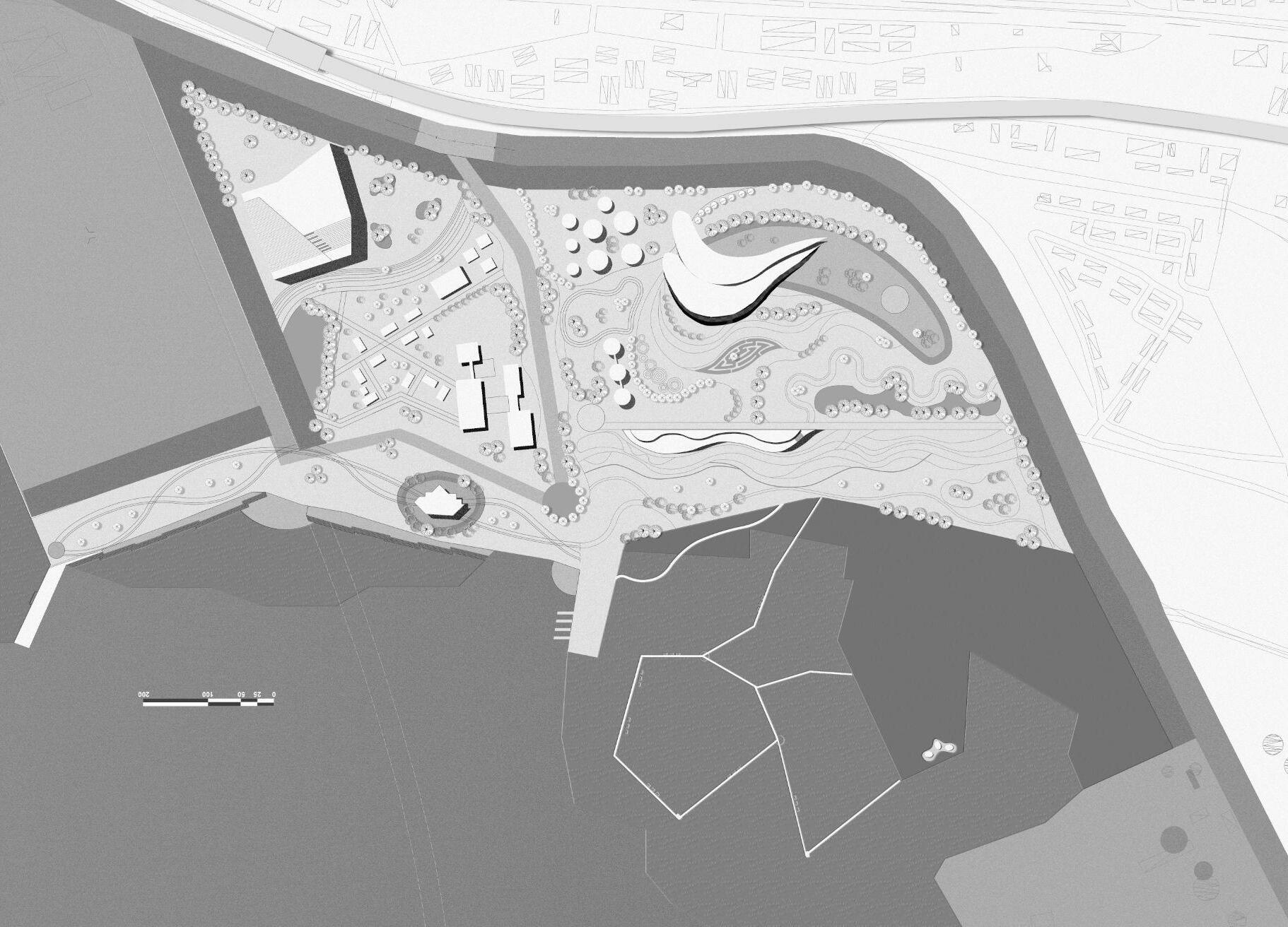
The proposal maximizes the available open space, while preserving the region’s ecological and industrial heritage. if realized, the project would provide relief to the adjacent slum development, and would work closely with the local community to develop appropriate activities for a range of potential users. In addition to the open space and the programming within the refinery tanks, the plan includes integration of the wetlands,restoration of the sewri fort, a multi purpose promenade, a docking area for water taxis and a cultural centre.

44

Elevated bridge Fort Greenhouse
structure Organic landscapesteps Cultural
Streetswith activities Ecologicalcentre Terracedcafes Visitorscentre Children'spark Jetty Community gardens Historiccentre Boardwalk Cafe+viewing gallery Promenade MiyawakiForest 10.1
45
Pathwaywith pausepoints Existingrefinery
centre+Exhibition
SITE ISOMETRIC DEVELOPMENT
10.2 BUILT MASSES 01- Preserving existing context
1. Adaptive Reuse of the Refineries
1. Each of the 3 tanks has a different programme and exhibition strategy chosen for it and, inside them, a range of different spaces havebeensetuptohouseartinallitsforms.

Tank1,spreadacrosstwolevels,featuresamusicclubupstairsand a cafe downstairs, with curved walls to optimise the acoustics during concerts. A restaurant has been set up in Tank 2 with a large, circular central atrium, whilst a roof terrace also allows diners the option of enjoying a meal in the open air. These two spaceshavedirectaccesstogroundlevel,bywayoframpsthatare covered with the same white metal panels used now used to cover thetanks.
2. Museum of History
2. Right on the main entry access, lies the visitor centre and utility block. For any large public space to run efficiently, the right informationandguidanceiscrucial.
Just behind this lies the Museum of History overlooking the fort precinct.Tovalueaspaceit’simportanttobeawareofitspastand the purpose of its existence. Thus this centre will provide information about the Colonial history and establishment of the portalongwiththefortbuiltfordefencemechanism.

46
10.2 BUILT MASSES 02 - Promoting Tourism

1. Cultural Centre
1. Celebration, cultural events, festivities are the highlight of any Indiancity.BeingMumbaiitonlytakesthevibranceaastepahead. The cultural centre designed as a stepped terrace looks out to both the city on one side and the La-la land on other. This contrasting viewpoints are thus generated to make one aware of its present while appreciating the future prospect the city offers. Large scale, art galleries, exhibition can be held in this building along with boosting cultural performances, The large plaza alongsidecanbeusedforcelebrationsbyneighbourhoodpeople.
2. Every public development needs to be supported by economical activities that will help generate employment and revenue for the maintenance of the place. Th waterfront restaurants are hence designed to attract people from national and international streams boosting tourism. The form of the structure is derived from the ship as the site had a ship breaking yard. Timber is used as a major element which attributes to the reused timber derived from the industry. The form is organic, flowyresemblingtheseaandthuswillformamajorattraction.
2. Waterfront Restaurants

47
10.2 BUILT MASSES 03 - Creating Ecological awareness


1. Ecological centre +Greenhouse
1. The diverse habitat and surrounding marshlands present on the eastern waterfront makes it vital to make people aware of its benefits. The Eco-centre thus will help to motivate and promote to reflect on the depleting green cover from the centre. They say ignorance is bliss, but mattersliketheseneedourimmediateattention.Inthegreen house, people can experience the Biodiversity and this will betheveryfirstsuchinitiativeinthecity.
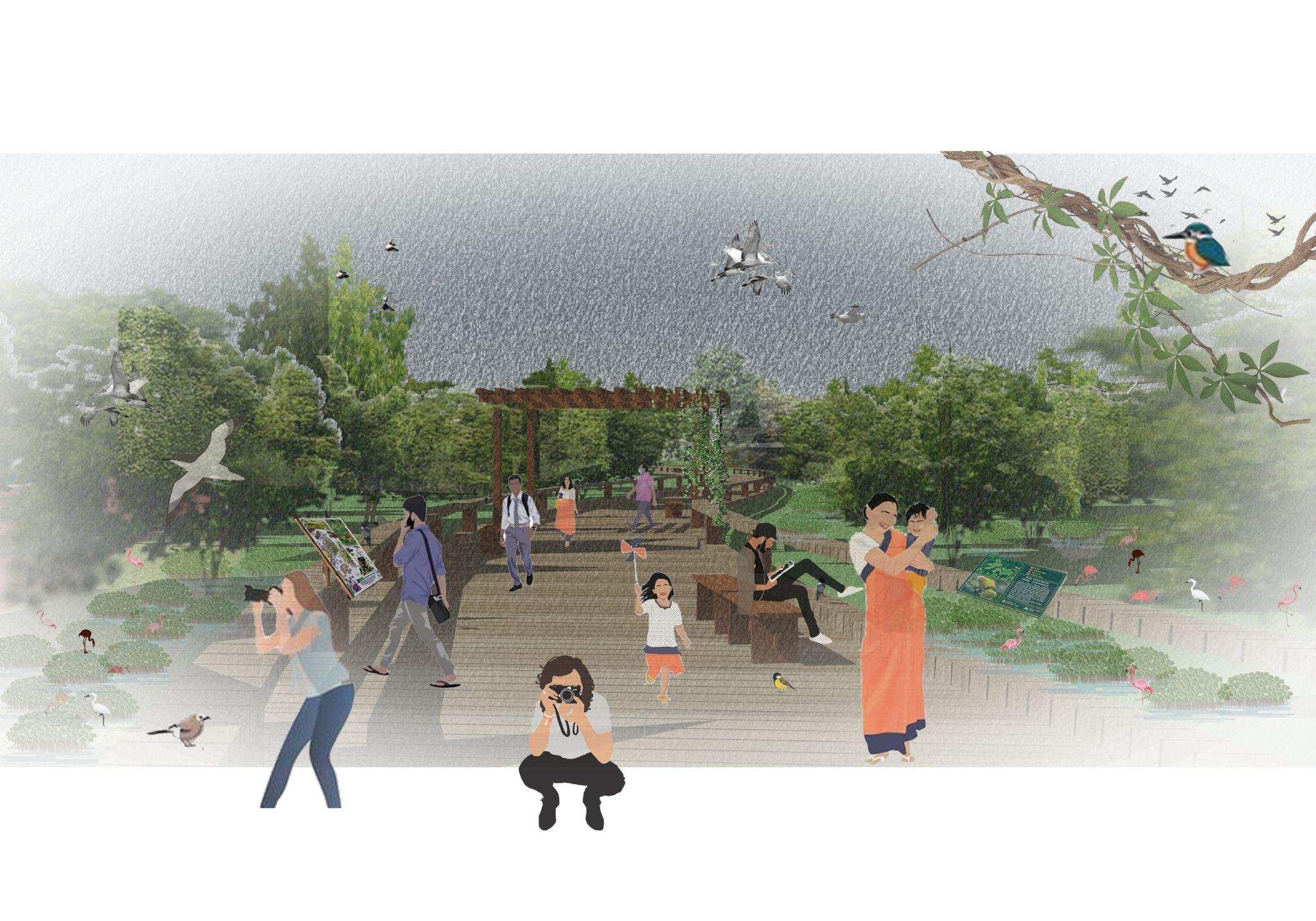
2. The Boardwalk sets one right in the lap of nature. The Miyawaki forest pathway leading to the walk aims at creating the experience of a forest trail. Awareness can be created by exhibitions, banners butthebestformisalwaystoexperience.Theboardwalkabout2.7 m wide is thus designed in wood with seatings along inviting tourists and city people to experience the flamingos. It will form a viewingpointforthemigratingbirdsandalsoamangrovewalk.
2. Mangrove Boardwalk

48
PROPOSED DESIGN ELEMENTS



49
10.3
Landscape amphitheatre
Outdoor gym+sports court
Museum of History

Refineries- Exhibition spaces
Ecological centre

Organic farming
Botanical garden
10.4
1 2 3 7 4 8 9 10 20 14 13 18 17 19 12 22 11 21 25 24 16 20 23 6 5 15 26 13 1.
2.
3.
4.
5.
6.
7.
8.
9.
10.
11.
12.
13.
14.
15.
16.
17.
18.
19.
20.
21.
22.
23.
24.
25.
26.
50
PROPOSED MASTER PLAN Legend:
Cultural centre
Public Plaza
Community centre
Senior citizen park
Active streets
Visitor centre+utility
Sewri Fort
Fishing deck
Children's park
Sensory park
Hedge Maze
Waterfront restaurants
Promenade
Landscape mounds
Jetty/ water transport
Miyawaki forest
Utility+Ticketing
Boardwalk
Underbridge plaza
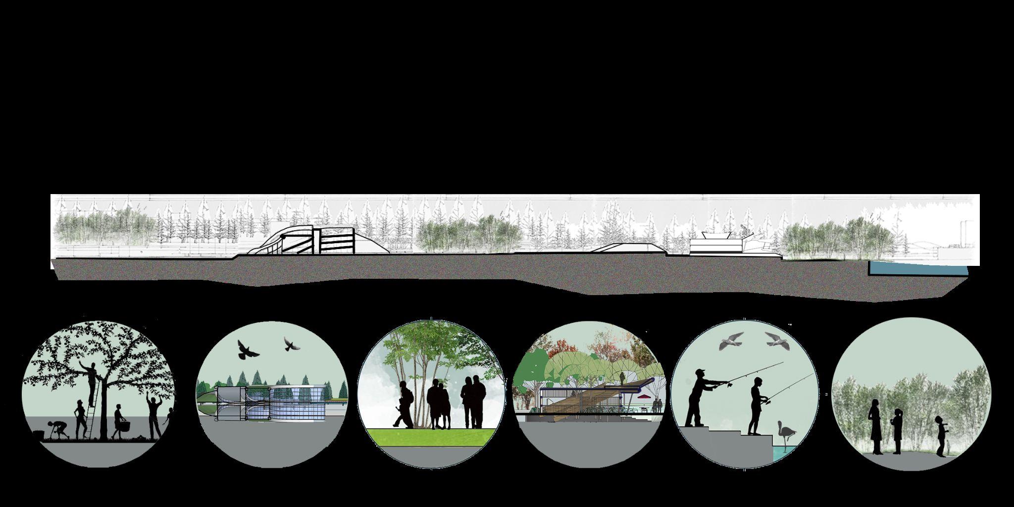
The section is developed as a stepped landscape descending towards the sea. The built masses are evenly distributed and set within designed landscape. The community garden is setneartheroadmakingiteasilyaccessibletotheneighbourhoodpeople.


1 2 3 4 5 6 51
Community Orchard Leisure Landscape Deck Activities 2 4
6
The section development along the southern zone consists of the stepped form of cultural centre, the organic landscape, streets with food vendors and stalls, further going down to thefort.Thisisthebusierzonewithmanyactivityfunctionsdispersedalongthewidth.


52


1A 1B 53
11. Key Design Elements

54
ADAPTIVE REUSE- REFINERIES


Industrialheritagebuildsonthehistory and identity of a place. It shapes a community’s culture and traditions. The longer the industrial apparatus is present in the skyline, the more that industry becomes a symbol to the place, and the more it identifies with the community’s cultural image.
● Preserve the port history
● Revamp old buildings


● Retain Iconic structures
● Use as installation, exhibition space, community centres
Art Installation, Northam, Australia
 Tank art centre, Shanghai
Car Park, Netherland
55
Proposed view of Refineries
As part of the proposal, the structures-relics of the area’s industrial past, would be transformed as the focal point of a modern-day park, containing vertical gardens, art and performance spaces, and the facade can even serve as an art canvas displaying vernacular art forms. Preserving the tanks not only gives the chance to create a dynamic, interactive, and educational public space, it is also the more affordable, safe, practical and sustainable option. To create a contrasting canvas for the refineries, a kids play area is planned along it. Thetwoglorifythevariationbetweenpastandfuture.


56
Proposed sectional development

Green roof
Metal truss
The large volume of the existing tank is divided into multi level spaces with addition of newdeckingfloor.Theouterfacadeofthetanksismaintainedwithadditionofanewlayer inside which will help cut off the element of toxicity. Further openings are added to introduceplayoflightandcreateadynamicfacade.Thedoubleheightspaceswillbeused for larger hanging exhibits along with wall arts and displays. Addition of lift block will make the terrace roof accessible to the less abled. An external connecting bridge links all therefineriestocreateawellconnectedaccess.
Section through refinery

New inner layer
Refinery facade
Metal decking flooring Facade glazing
Raised
plinth
Wall section
57
Proposed view of the History Museum and Visitors centre

The Museum of history overlooking the fort gives people the opportunity to be aware of its historical relevance. At present the fort is a hidden gem, not really known as a tourist spot, thus restoration will encourage people to visit the same.

58
Envisioned Promenade Activities


Multilevel Pedestrianbridge Amphitheatre WaterTaxistop
 Niederhafen, Hamburg, Germany Pedestrian bridge, Rhode Island Shekao Promenade, China
59
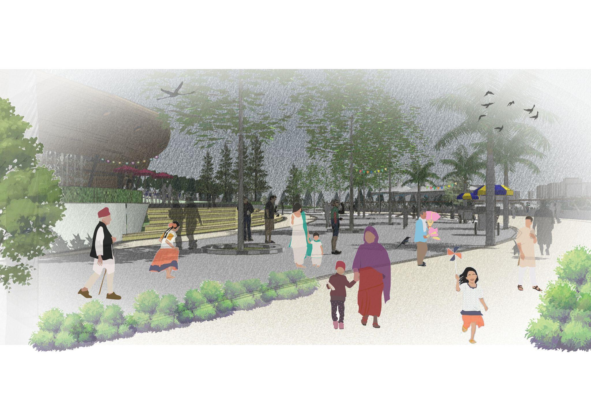
Activities such as jogging, leisure walk, seating areas, cycling tracks, shaded roofing are all proposed within the promenade. This gives an opportunity for users of all age groups to come together in the same setup.


60
encourage people and result in decongesting of the high traffic western waterfront for recreations. It will provide an opportunity to the people of all social backgrounds to connect at a common ground.

61
Proposed view of the Restaurant entry


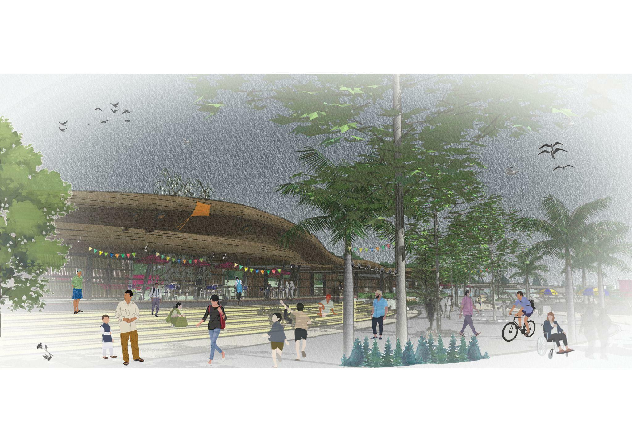
Over the years the industry has employed locals thus providing livelihood to many households. The curve form of the timber roof is derived from a sail which is thus a tribute to the present ship breaking industry existing on site.

62
Rotterdam Clubhouse, Amsterdam Museum of Arts Lisbon
Proposed Overview of the Seafront Restaurant
The proposed organic layers of landscape and overlooking seafront terraces shall promote tourism and make it a state of art facility. The multi levels also help in generating various viewpoints thus providing visual access to the site, this in order leads to the user feeling secure and safe at all times.


63
Proposed Overview of the Seafront Restaurant


Perforated screens play a vital role in the vernacular architecture of the country. We have seen this influence of mughal architecture further being imbibed into the local style. The facade for the structure is thus designed in a perforated timber screen, which provides visual connectivity and also prevents obstruction of wind flow thus encouraging natural ventilation.
 Metal colonnades
Timber screen
64
Perforated facade Reused timber
Proposed terrace view of the Seafront Restaurant

The waterfront rooftop is proposed as a 12 mt high block with an open terrace at the roof. This overlooking terrace shall provide unobstructed, stunning views to the mangroves, migrating flamingos and the fort precinct. It is envisioned as a space where one would love to see the morning sun rising in its glory.

65
Proposed concept of the Cultural zone Sectionaldevelopment
The linear block is broken into 2 parts, further sloping each in opposite direction, leading into generation of 2 sloped terraces. Access for each is provided in the form of stepped slab, which makes the entire surface accessible from ground level externally. This shall thus encourage people to utilise the terrace without disturbing the internal exhibition spaces. A green roof proposed on the surface acts as a percolation surface, thus attracting wildlifeandbiodiversity.


 Massing sketch
66
KeyPlan
Proposed view of the Cultural zone

The cultural centre overlooks the sea on the east and the residential development on the west. The stepped terrace provides spectacular views of the public plaza and activities further overlooking the fort. The will act as an amphitheatre during performances and events held in the plaza. The centre is designed to house a museum and an exhibition space displaying works of Mumbaikars.

67
Proposed roof view of the Cultural centre
Proposed view from the trans harbour link, with the green roof. Green roofs have several advantages including reducing heat island effect, improving air quality, providing habitat for wildlife, reducing stormwater runoff, and extending the lifespan of the roof. Overall, green roofs can have a positive impact on the environment and the community while also providing aesthetic and recreational benefits.


68
Public Plaza Activities in the city


 Covent Garden, London Carnival, Ljubljana, Slovenia Street theatre, Mumbai, India
Flea Market, New Delhi Food festival, New Delhi Celebrating Holi, Mumbai
69
Celebrations Events Theatre Flea Markets
Proposed view of the Cultural centre plaza

Public plazas in Mumbai can host a variety of cultural activities that reflect the diversity of the city's population. These activities can include music and dance performances, festivals, art exhibits, and food fairs. They can also be used as spaces for community gatherings, such as political rallies, religious celebrations and social events. This plaza can also often be used for Yoga classes and other fitness activities.

70
Jan Gehl said, ‘when spaces are designedforhumanproportionand scale they feel safe. In a scale where they can relate and are busier people tend to walk slowly comparedtoanemptyspace.’


● Derived from the city's street character
● Active public zone

● Compact dimensions keeping the space oriented.
● Activities such as street theatre, flea markets, local fairs, food trucks, Art display
Active Streets and
Nodes
Tel Aviv Israel
71
Third street promenade, California
Proposed view of the Streets

In Mumbai, streets are considered as important public spaces, where people from different backgrounds and cultures interact with one another. Streets are not only used for transportation, but also as places for socializing, vending, and other activities.These streets are designed as narrow linear spaces that can host food stalls, local theatre, fun fairs and a space for the local fishing community to display their skills. It will serve as an economy generating opportunity for the neighbouring communities.

72
Organic Landscaping

● Organic landscape levels

● Softscape near water edge helps to pertain overflow during flooding

● Curve pathways generates a free flow

● Multi levels initiate a sense of visual connect and interest.
● Generates a sense of safety and security
Galaxy Soho, Beijing
Tianjin Cultural park
Koper Park, Slovenia
73
Sketchviewoforganiclandscape
Proposed view of the landscape paths

Many large open arenas are designed in order to host large scale events. People have the luxury to enjoy these plazas at their own leisure. Flexible open plazas are used for multipurpose setups and events. Senior citizens can take a quiet stroll away from the sea coast promenade and spend an evening with friends.

74
Eco-Awareness
Our environment, which gives us all the necessary elements for our survival, is now in danger with our activities.
Our ill effects include deforestation, pollution, overfishing, natural habitat destruction, etc. These all are causing pain to our mother nature and dreadful scenarios for humans. It is thus a priority today to generate awareness of its existence and further conservation.
● Native landscape with dense network
● 10-30 years for full growth
● Attracts biodiversity

● Creates a natural context and generates interest

● Protecting the mangroves with natural envelope
 National Ecology centre, South Korea
Central facility of Island City, Japan
National Ecology centre, South Korea
National Ecology centre, South Korea
Central facility of Island City, Japan
National Ecology centre, South Korea
75
Proposed view of the Eco- centre

The form of the eco centre is derived from the leaves in nature, flowy, wrapping itself with a glazed facade. The green roof is accessible given the users a unique experience.it can serve as an urban oasis in a city known for its pollution and lack of green spaces. It can provide a place for people to relax, connect with natureandimprovetheirmentalandphysicalwell-being.Itcanalsohelptoimproveairqualitybyproviding a space to grow different plants that can act as natural air purifiers. Landscape elements such as a hedge maze,greenmounds,waterfountainsaredistributedalongthesite.

76
Proposed internal view of the Eco- centre
Mumbai yet does not have its own conservatory. It will serve as a place to relax and connect with nature, especially in urban areas where green spaces are limited. Additionally, conservatories will be used as educational spaces, providing hands-on learning experiences for students and adultsalike.Theycanalsobeusedasaplacetogrowplantsthatarenotnativetotheregionandcanhelptoimprovetheairquality.

77
● Climate Regulation
● Coastal Protection ● Air Purification ● Preserving biodiversity ● Ecological awareness ● Conserving mud lands ● Tourist attraction


The Mangrove Boardwalk
Bondi beach, Hongkong
78
The Gardens, Florida Pasir Ris, Singapore
Proposed view of the Boardwalk

A boardwalk will allow visitors to explore and appreciate these unique ecosystems without damaging them. Mangroves play an important role in protecting coastlines from erosion and storms, as well as providing habitat forawidevarietyofplantandanimalspecies.Boardwalkwillallowforbetteraccessandeducationaboutthese importantecosystems,andcanalsoserveasatoolforconservationandecotourism.
79
The Miyawaki Forest

● Native landscape with dense network

● 10-30 years for full growth
● Attracts biodiversity
● Creates a natural context and generates interest

● Protecting the mangroves with natural envelope


Be one with Nature Creating Experience
This Japanese technique has some significant benefits over more traditional forestry methods when used in smaller afforestation projects and is particularly effective in the urban environment.
Urban forest, Kuala Lumpur
80
Flamingo migration, Florida
Proposed view of Miyawaki Forest- Camping site

The Miyawaki forest serves as a pathway to the boardwalk. It involves planting a large number of native tree species very closely together, leading to a dense and diverse forest ecosystem. These forests are able to grow quickly and require minimal maintenance, making them a popular choice for urban green spaces.Activitiessuchacamping,schoolgetaways,bonfirenightscanbehostedhere.

81
12. FORT- PROPOSED RESTORATION

Abandoned deteriorating
Lost Hidden
Inaccessible Antisocial
It was built by the British East India Company in the 1680s and served as a watchtower for the Bombay Harbour. The fort is also a popular spot for birdwatching as it's the home of flamingoes Restoration, preservation and maintenance of the fort will bring back its former glory.. By means of ambient lighting, native landscape, adding information signages, the fort can be transformed into a socialmeetuppoint.

Preserved
Native landscape Informative signages
Existingcondition
Proposedrestoration
Ambient lighting Accessible Social
82
12. JETTY- PROPOSED TRANSFORMATION


Existingsite
Proposedrevamp
The viewing deck at present is a raw concrete slab. The same can be turned into an active plaza. WIth open exhibitions, fairs, seating areas and landscape it can be converted into a quaint spot. During the flamingo festival, it is widely accessed by people to view the birds. The flooring can be replaced with the raw timber planks extractedfromtheshipbreakingwhichwillretainitstruefeel.
83


13. TIMELINE-
4
PROPOSED PHASING
3
2
1
84
INTERNATIONAL TOURISM Cultural center Boardwalk Miyawaki forest
NATIONAL CONTEXT Eco-tourism Waterfront restaurants
URBAN CONTEXT History Museum Adaptive Reuse Landscape plaza
LOCAL CONTEXT Fort precinct restoration Community centre Promenade
“
First we shape the cities – then they shape us.”
“The city throughout the history of mankind has been the meeting place for people. Much of the culture of mankind has happened in the public space. Public space is a very important aspect of a good and well functioning city.”
-Jan Gehl

The proposal if envisioned aims to increase the per capita open space for the city of Mumbai from current 1.3 sqkm/person to the minimum of 9 sq.km / person. If shown light the LaLa Land will provide a much needed breathing space for the inhabitants giving the city something of its own. If envisioned it will help in increase of the POS percentage in Mumbai from the present 6% to 10%.
As most tourist places currently are from the colonial era, this will be the pride of the city in coming years. It is proposed to be an inclusive development that aims to provide a platform for all social hierarchy opening out to communities at all levels. This can be the hope for the future generation and can set a precedent for other unused and underutilised parcels in the city. For economic growth of the country, commercial and residential development is a necessity but along with the same the existence of public open space shall not be ignored. It is only if the built and unbuilt growth together in unanimity will the city of Mumbai truly flourish.
14. WAY FORWARD
85
(Adaptive traditions of the Eastern Waterfront of Mumbai, India, n.d.)
Adaptive traditions of the Eastern Waterfront of Mumbai, India. (n.d.). Asla.org. Retrieved 27 January 2022, from https://www.asla.org/2020studentawards/1192.html (Behance, n.d.)
Behance. (n.d.). Behance.net. Retrieved 26 January 2022, from https://www.behance.net/gallery/60820539/An-Illustrated-Documentary (Chaudhary, 2022)
Chaudhary, S. (2022, March 28). Homegrown artist illustrates 100 days at home through the house door. Homegrown. https://homegrown.co.in/article/806247/homegrown-artist-illustrates-100-days-at-home-through-the-house-door (City and regional planning, n.d.) City and regional planning. (n.d.). Upenn.edu. Retrieved 29 March 2022, from https://www.design.upenn.edu/city-regional-planning/graduate/work/mumbai-eastern-waterfront-plan (Frampton, 2006)
Frampton, K. (2006). Manuel de Sola-Morales: A Matter of Things. NAI. (Ganatra, 2021)
Ganatra, S. (2021, August 5). Mumbai port complex master plan - HCP design, planning and management pvt. Ltd. HCP Design, Planning and Management Pvt. Ltd. https://hcp.co.in/urbanism/mumbai-port-complex-master-plan/
15.
Bibliography / References
86
(Hudson, 1996)
Hudson, B. J. (1996). Cities on the shore: The urban littoral frontier. Cengage Learning EMEA.
(Koli woman-The native fisherwoman from Mumbai, n.d.)
Koli woman-The native fisherwoman from Mumbai. (n.d.). Talenthouse. Retrieved 17 March 2022, from https://www.talenthouse.com/item/1535572/c85a38fd (Luco et al., 2022)
Luco, A., Florian, M.-C., Pintos, P., Cano, P., Souza, E., Volner, I., Silva, V., Prieto, C., Abdel, H., Chen, C., & Caballero, P. (2022, April 03). ArchDaily. ArchDaily. http://www.archdaily.com (McGlynn & Hayward, 1993)
McGlynn, S., & Hayward, R. (Eds.). (1993). Making better places: Urban design now. Butterworth-Heinemann. (Metro sky gardens, Mumbai, 2014)
Metro sky gardens, Mumbai. (2014, March 15). Arjun Rathi. https://arjunrathi.wordpress.com/2014/03/15/metro-sky-gardens-mumbai (Mumbai’s Eastern Waterfront– Giving the sea back to the city, 2014)
Mumbai’s Eastern Waterfront– Giving the sea back to the city. (2014, June 27). Architecture And Conservation. https://architectureandconservation.wordpress.com/2014/06/27/mumbais-eastern-waterfront-giving-the-sea-back-to-the-city/ (Mumbai:Shift, n.d.)
Mumbai:Shift. (n.d.). DA | S. Retrieved 15 March 2022, from https://www.designactionstudio.com/mumbaishift
87
(Rao, 2019)
Rao, Y. (2019, August 31). Mumbai Metropolitan Region’s built-up area up 350% in 40 years: Study. Times Of India.
https://timesofindia.indiatimes.com/city/mumbai/mumbai-metropolitan-regions-built-up-area-up-350-in-40-years-study/articleshow/70918285.cms (Research & Design Cell, 2001)
Research, & Design Cell. (2001, December 19). Study of the Eastern Waterfront of Mumbai: A situation analysis, 2001. Research and Design Cell.
https://krviadesigncell.wordpress.com/2001/12/19/study-of-the-eastern-waterfront-of-mumbai-a-situation-analysis-2001/ (UDRI, 2016)
UDRI. (2016, August 6). A vision plan for Mumbai’s Eastern Waterfront. URBAN DESIGN RESEARCH INSTITUTE.
https://www.udri.org/projects/vision-plan-mumbais-eastern-waterfront/ (Venkatraman, 2019)
Venkatraman, T. (2019, January 5). Mumbai Port Trust releases plan for revamp of eastern waterfront. The Hindustan Times.
https://www.hindustantimes.com/mumbai-news/mumbai-port-trust-releases-plan-for-revamp-of-eastern-waterfront/story-mg3u7FAiBpnt1Z6afCSVMP.html (Rao, 2019)
Rao, Y. (2019, August 31). Mumbai Metropolitan Region’s built-up area up 350% in 40 years: Study. Times Of India.
https://timesofindia.indiatimes.com/city/mumbai/mumbai-metropolitan-regions-built-up-area-up-350-in-40-years-study/articleshow/70918285.cms
(Research & Design Cell, 2001)
Research, & Design Cell. (2001, December 19). Study of the Eastern Waterfront of Mumbai: A situation analysis, 2001. Research and Design Cell.
https://krviadesigncell.wordpress.com/2001/12/19/study-of-the-eastern-waterfront-of-mumbai-a-situation-analysis-2001/
88
Copyright reserved by Heena Jameel Ahmed Shaikh MA Architecture and Urbanism


89
Copyright @2022 Manchester, United Kingdom ALL RIGHTS RESERVED Manchester School of Architecture


 Marine drive
Juhu Beach Carter Road Bandstand
Bandra fort
Worli Seaface


 Tank art centre, Shanghai
Car Park, Netherland


 Niederhafen, Hamburg, Germany Pedestrian bridge, Rhode Island Shekao Promenade, China


 Metal colonnades
Timber screen


 Massing sketch


 Covent Garden, London Carnival, Ljubljana, Slovenia Street theatre, Mumbai, India
Flea Market, New Delhi Food festival, New Delhi Celebrating Holi, Mumbai


 National Ecology centre, South Korea
Central facility of Island City, Japan
National Ecology centre, South Korea
National Ecology centre, South Korea
Central facility of Island City, Japan
National Ecology centre, South Korea


