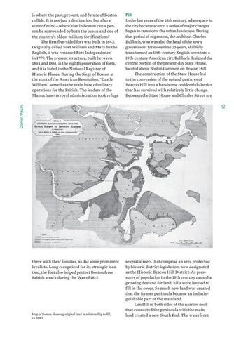
Fill In the last years of the 18th century, when space in the city became scarce, a series of major changes began to transform the urban landscape. During that period of expansion, the architect Charles Bulfinch, who was also the head of the town government for more than 25 years, skillfully transformed an 18th-century English town into a 19th-century American city. Bulfinch designed the central portion of the present-day State House, located above Boston Common on Beacon Hill. The construction of the State House led to the conversion of the upland pastures of Beacon Hill into a handsome residential district that has survived with relatively little change. Between the State House and Charles Street are
there with their families, as did some prominent loyalists. Long recognized for its strategic location, the fort also helped protect Boston from British attack during the War of 1812.
several streets that comprise an area protected by historic district legislation, now designated as the Historic Beacon Hill District. As pressures of population in the 19th century caused a growing demand for land, hills were leveled to fill in the coves. So much new land was created that the former peninsula became an indistinguishable part of the mainland. Landfill in both sides of the narrow neck that connected the peninsula with the mainland created a new South End. The waterfront
13
Daniel Vasini
is where the past, present, and future of Boston collide. It is not just a destination, but also a state of mind—where else in Boston can a person be surrounded by both the ocean and one of the country’s oldest military fortifications? The first five-sided fort was built in 1643. Originally called Fort William and Mary by the English, it was renamed Fort Independence in 1779. The present structure, built between 1834 and 1851, is the eighth generation of forts, and it is listed in the National Register of Historic Places. During the Siege of Boston at the start of the American Revolution, “Castle William” served as the main base of military operations for the British. The leaders of the Massachusetts royal administration took refuge
Map of Boston showing original land in relationship to fill, ca. 1880.

