Macau’s Urban Transformations
39
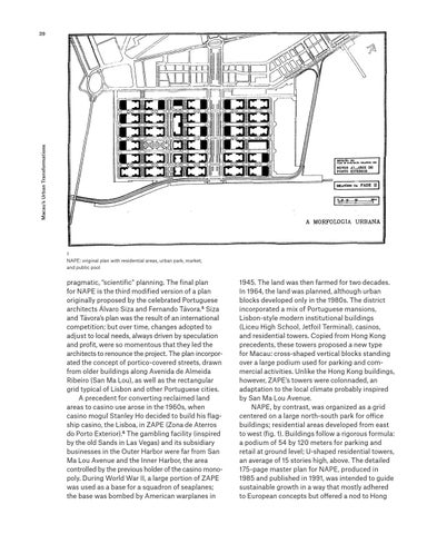
1 NAPE: original plan with residential areas, urban park, market, and public pool
pragmatic, “scientific” planning. The final plan for NAPE is the third modified version of a plan originally proposed by the celebrated Portuguese architects Álvaro Siza and Fernando Távora.5 Siza and Távora’s plan was the result of an international competition; but over time, changes adopted to adjust to local needs, always driven by speculation and profit, were so momentous that they led the architects to renounce the project. The plan incorporated the concept of portico-covered streets, drawn from older buildings along Avenida de Almeida Ribeiro (San Ma Lou), as well as the rectangular grid typical of Lisbon and other Portuguese cities. A precedent for converting reclaimed land areas to casino use arose in the 1960s, when casino mogul Stanley Ho decided to build his flagship casino, the Lisboa, in ZAPE (Zona de Aterros do Porto Exterior).6 The gambling facility (inspired by the old Sands in Las Vegas) and its subsidiary businesses in the Outer Harbor were far from San Ma Lou Avenue and the Inner Harbor, the area controlled by the previous holder of the casino monopoly. During World War II, a large portion of ZAPE was used as a base for a squadron of seaplanes; the base was bombed by American warplanes in
1945. The land was then farmed for two decades. In 1964, the land was planned, although urban blocks developed only in the 1980s. The district incorporated a mix of Portuguese mansions, Lisbon-style modern institutional buildings (Liceu High School, Jetfoil Terminal), casinos, and residential towers. Copied from Hong Kong precedents, these towers proposed a new type for Macau: cross-shaped vertical blocks standing over a large podium used for parking and commercial activities. Unlike the Hong Kong buildings, however, ZAPE’s towers were colonnaded, an adaptation to the local climate probably inspired by San Ma Lou Avenue. NAPE, by contrast, was organized as a grid centered on a large north-south park for office buildings; residential areas developed from east to west (fig. 1). Buildings follow a rigorous formula: a podium of 54 by 120 meters for parking and retail at ground level; U-shaped residential towers, an average of 15 stories high, above. The detailed 175-page master plan for NAPE, produced in 1985 and published in 1991, was intended to guide sustainable growth in a way that mostly adhered to European concepts but offered a nod to Hong