Social Science
PRIMARY
Globalaction 12MONTH LICENCE DIGITAL PROJECT INCLUDED
4
sample
What are we going to learn?
1 Where do fires do the most damage?
8
2 Is water undervalued? 24
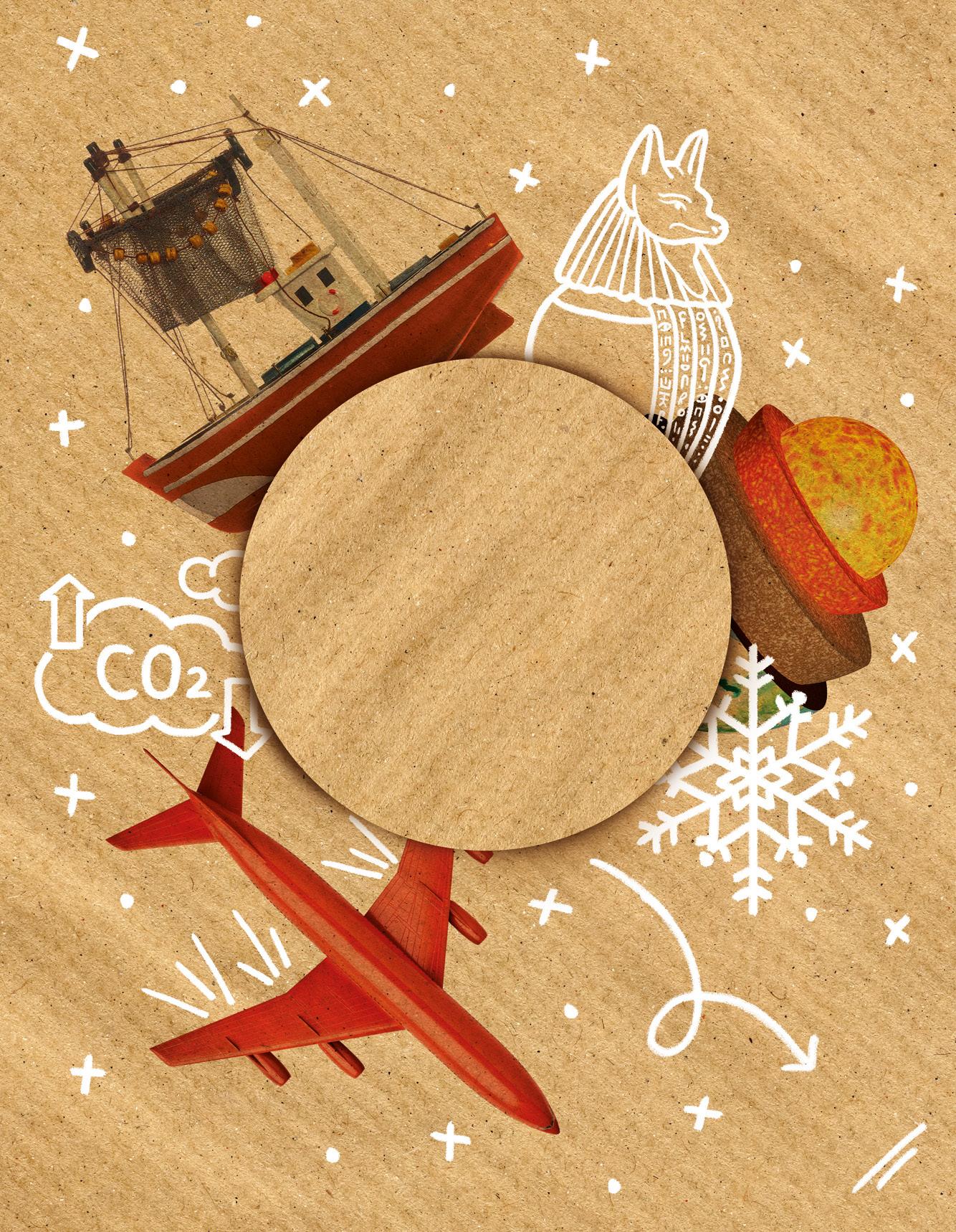
Learning situation: The number of forest fires in Spain is increasing every year. In 2022, it recorded the worst numbers of the century.

Target in action: Report the increase in the number of fires and give advice on how to avoid them by recording a video to stop them.
3 What does nature give us? 42
Learning situation: Inequalities in access to safe drinking water around the world are growing.

Target in action: Create a sign to make people conscious of the importance of saving our available drinking water. Clean water and sanitisation
Learning situation: The fundamental role of bees in the biodiversity of the planet and their possible extinction because of climate change.
Target in action: Create a poster explaining how sustainable development of rural and maritime trades is necessary and important to end hunger. Zero hunger 4 Industry 4.0 58
5 How have our habits changed? 80
6 Understanding history, a path to peace
98
Learning situation: The digitalisation of industry, or Industry 4.0, the current phase of the production process.

Target in action: Write an email to the ministry explaining the need to change the sector for a sustainable present and future. Industry, innovation and infrastructure
Learning situation: The direct influence of people's lifestyles on health.

Target in action: Campaign to promote a healthy lifestyle. Good health and well-being

Learning situation: Reflecting on the importance of peace for civilisation's development.
Target in action: Provide data and ideas to educate and inform about the importance of the culture of peace. Peace, justice and solid institutions

PAGE LEARNING SITUATION TARGET IN ACTION SDG Life on land
INTERDISCIPLINARY TERM 1 REVIEW TERM 3 REVIEW TERM 2 REVIEW
KNOWLEDGE TO LEARN, APPLY AND INVESTIGATE
• The atmosphere. Atmospheric phenomena
• Atmospheric weather. The meteorological map
• The climate. Elements and factors
• Climate zones and types of climates
• The climograph
• The climatic landscapes in Spain
• Climate change
• The hydrosphere. The states of water. The water cycle
• Surface water and groundwater
• Rivers. Elements and characteristics
• The Spanish hydrographic basins
• Responsible water consumption
• Geographic Information Technologies
Competence-based activities
• Climate and fire
• Let's stop fires!
• Keep your community safe!
Competence-based activities
• Less and less water is available!
• The waters around me
• Are we taking care of our rivers?
• Who consumes less water?
INTERDISCIPLINARY PROJECT · Eco-Action Magazine: Eco-report
• Natural and processed products
• Agriculture. Types and tasks
• Forestry
• Livestock farming. Types, tasks and livestock
• Fisheries and aquaculture
• Spain's primary sector
• Ecosystem and biodiversity conservation
• Mining and energy sources
• Crafts. Types. Workshop work.
• Industry. Types. Factory work
• Transport. Types and means
• Trade. Classification
• Tourism. Types. Public services
• Economic activity
Competence-based activities
• Can only rich countries make processed products?
• How can I help you?
• No to animal abuse!
• A blue transformation
• Do we care for the world together?
Competence-based activities
• How does this machine work?
• What order can it happen in?
• Does my company need transport means?
• Where does the business activity happen?
• Do I need money for my business?
INTERDISCIPLINARY PROJECT · Plastic-free mission: Now or never
• Dating. Historical time. Historical sources
• Historical ages.
• Prehistory. Palaeolithic, Neolithic and Metal Ages. The Peninsula in prehistory
• Human evolution
• The Ancient Ages in Spain
• The colonising peoples
• The pre-Roman peoples
• Roman Hispania. Romanisation
Competence-based activities
• Life expectancy in prehistoric and modern times
• Three to four pieces of fruit a day!
• The Neolithic Age and the appearance of tooth decay
• Physical activity for everyone!
Competence-based activities
• What did the colonising peoples contribute?
• Different languages that add value to our cultural heritage
• Human rights
INTERDISCIPLINARY PROJECT · Silent water pollution: Eco-soap
1 Where do fires do the most damage?
"Spain had the worst fire season of the century in 2022. Forest fires destroyed around 300,00 hectares.". The day after reading the news, Laura came to class to discuss it with her teacher. Her grandfather lives in Zamora, the province worst affected by the fires, and has lost some of his property. She wants to understand how this happens and, most of all, if there is anything she can do to prevent a situation like this in the future.
What do you think?
Why do you think forest fires happen? Do you think they are natural or provoked? What action is taken to prevent them? What are the consequences?
Context
In this unit...
Target in action
Record a video talking about the increase in fires and giving advice on how to prevent fires in our local countryside.
The General Directorate for Civil Protection and Emergencies of the Ministry of the Interior says that 95 % of forest fires are caused by people, who are not careful.
Follow the thread!
The


atmosphere and atmospheric phenomena
1
Why do we check the weather forecast every day?

The climate
2
What weather elements can influence fires to spread?
8
Climates in Spain
3
Which areas of Spain are most at risk from fires?
4
The climographs We show the climate
Climate and landscape
5
Which landscapes are most affected by fires?

Climate change and GITs
6
We study how the climate is changing
9 15
Why do we check the weather forecast every day?

The weather affects our everyday life. It tells us what type of clothes to wear, if we will need an umbrella, sunglasses...
Why is the atmosphere so important?
The atmosphere is the layer of gases surrounding the Earth, primarily nitrogen, oxygen and carbon dioxide. It is essential for life to exist on our planet because:
• It filters dangerous solar radiation.
• It regulates the planet's temperature, making it habitable.
• It contains gases necessary for breathing and photosynthesis of living beings (oxygen and carbon dioxide).
Atmospheric phenomena
Atmospheric phenomena are things that happen naturally in the atmosphere: wind, clouds, precipitation, etc.
To find a summary of the unit, watch the video 'Let me tell you' on anayaeducacion.es

The air in the atmosphere moves because of temperature changes, resulting in wind


10
1
When temperatures go down, the condensed water in the clouds falls to the earth's surface as rain (liquid water), snow or hail (solid water).
Clouds are formed when water droplets condense in the atmosphere after evaporation.
How is the weather?
Atmospheric phenomena determine atmospheric or meteorological weather , understood as the state of the atmosphere at a time and place.
Atmospheric weather changes a lot and we study it in meteorology . The aim of meteorology is to forecast the weather in 24 or 48 hours and to produce a short or medium-term weather forecast.
We see analysis and predictions everyday in meteorological maps or weather maps

One of the most special atmospheric phenomena is the rainbow. Rainbows happen when it rains and the raindrops act as mirrors, dispersing and splitting the light. Polar auroras is another, which you can only see at specific locations on the planet. They are the result of the interaction of the earth's magnetic poles and particles transported by solar wind.

1 Write around List the reasons why the atmosphere is important for living things.
2 Which atmospheric phenomenon is this?
• It is formed because of the condensation of water droplets in the atmosphere.


• Condensed water in the clouds comes down to the surface.
• Movement of the air in the atmosphere.
3 What makes you say that? Look at the weather map and describe the weather in your region.

Take note!
Recently, there is more extreme atmospheric or meteorological phenomena such as snowfalls, heat waves, torrential rain, tornadoes, etc.
U1 11
Mediterranean Sea ATLANTIC OCEAN Sun Sun and clouds Clouds Snow Rain Wind The weather 0 100 200 300 km The
Cantabrian Sea ATLANTIC OCEAN
meteorological map
What weather elements can influence fires to spread?
What data should be considered when defining a high-risk fire area?
What is climate?
Climate is a set of frequent atmospheric conditions at a particular location that is determined after a study of the atmospheric weather in that area over several decades. This study helps establish the frequent behaviour of atmospheric phenomena at a particular location.
Weather elements
Weather elements are the set of components that characterise the atmospheric weather and how they interact with each other. They are essential for reliable weather forecasting.

Weather elements
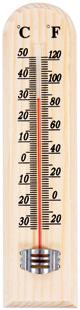
Temperature . This is the quantity of heat energy accumulated in the atmosphere. It is measured in degrees Celsius (ºC), with a thermometer
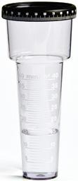
Precipitation . This is water falling on the earth's surface. It can be in a liquid or solid state. It is measured in litres per m 2 with the rain gauge
Humidity. This is the quantity of water vapour in the atmosphere. The higher the temperature, the lower the humidity. It is measured with the hygrometer
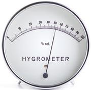
1 Name the weather elements and the instruments used to measure each of them.
2 Pencils in the middle What are climatic factors? Name the ones that you think influence where you live and which ones do not.
3 Create your own weather station in class.
Cloud cover . It is the quantity of clouds.
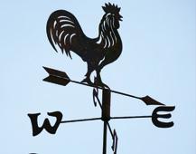
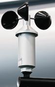
Wind . This is the movement of air in the atmosphere. Its speed is measured with the anemometer, in metres per second (m/s), and its direction is shown by a wind vane
Atmospheric pressure
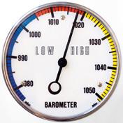
This is the weight that a mass of air presses on the earth's surface. It is measured in millibars, using a barometer
12 2
Climatic factors
Climatic factors are the climatic conditions of a specific area. Depending on these factors, the elements of the climate will be different and so will the climate.
To learn more about meteorological elements, watch the video "The weather station" on anayaeducacion.es.


The temperature reduces by 1 °C for every 100 metres of altitude.
This is the distance from any point on Earth to the equator or 0 ° parallel. The climate of an area is warmer when it is closer to the equator and colder when it is further away.
This is the height that any surface reaches above sea level. Altitude affects temperatures: the higher the altitude, the lower the temperature.

The water in the seas and oceans warms slower than the land, so it regulates the temperature of nearby areas, making them less extreme. The influence of the sea also affects wind and humidity.
Relief is the diversity of shapes that the earth's crust forms, such as mountain ranges, plains, valleys, etc. The climate in mountainous areas will be different from lowland areas.

U1 13
Latitude Influence of the sea Altitude Relief Cold Cold Hot 1,000 m 16 °C 2,000 m 10 °C 500 m 20 °C Milder climate More extreme climate
slow
winds and clouds.
Mountains
down
Which areas of Spain are most at risk from fires?
Not all parts of Spain have the same climate, so the risk of fire varies.
Climates of Spain
Spain is in the temperate climate zone of the Earth, because of its latitude.
All the climatic factors mentioned mean that Spain has a characteristic climatic diversity.

Climate and fire

The continental climate covers most of the peninsular surface. Temperatures are extreme, very cold in winter and very hot in summer, because of the limited influence of the sea. Precipitation is abundant in autumn and spring, sometimes torrential, and very low in summer.

In the southern sub-plateau and a large part of Andalucía there is a variety, the continentalMediterranean climate , with less extreme temperatures.

14
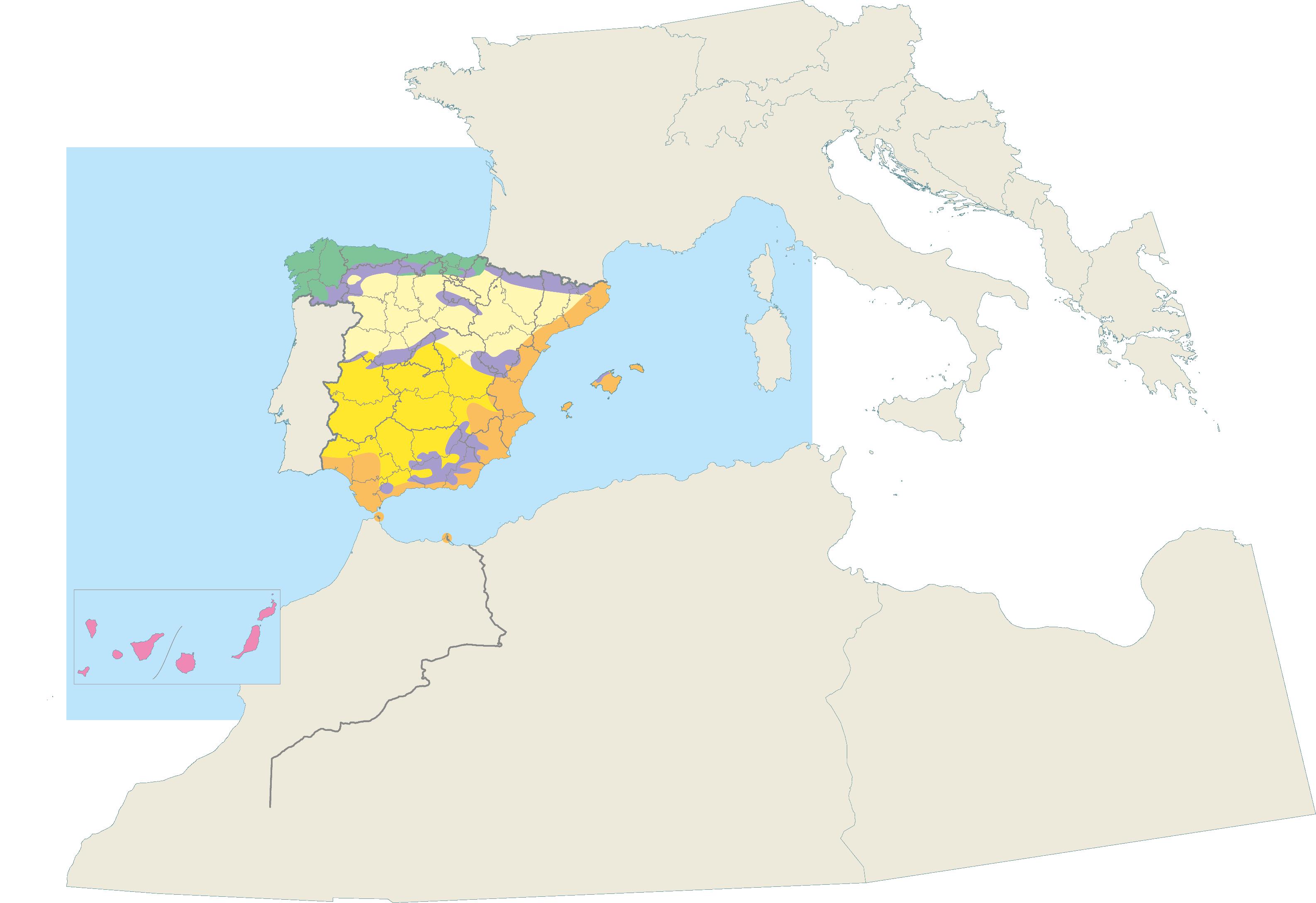
3 Climate zones of the Earth Hot zone Temperate zone Cold zone Temperate zone Temperate zone Hot zone Cold zone Cold zone Arctic Circle Tropic of Cancer Equator Tropic of Capricorn Antarctic Circle
Oceanic Continental Continental-Mediterranean Continental Mediterranean Mountain Subtropical
Las Palmas de Gran Canaria
ATLANTIC
ATLANTIC
Santa Cruz de Tenerife
OCEAN
OCEAN
The oceanic climate is found in the north of the peninsula. Its main characteristic is cool temperatures in winter and mild in summer. Precipitation is abundant throughout the year, but less in summer.
1 Draw a map of the climatic zones of Spain in your notebook.

2 What is the climate in the area where you live? What are its characteristics?
The mountain climate is found in high mountain areas. Temperatures are normally cold, even in summer, and go below freezing in winter. Precipitation is frequent, and snow falls in winter.
The subtropical climate in Spain is found in the Canary archipelago, because of its geographical location closer to the warm zone. Temperatures are usually warm all year and there is little difference between summer and winter. Precipitation is low, but higher in the northern islands than in the south.
The Mediterranean climate is located in the coastal areas of the south and east of the peninsula. This climate has mild temperatures in winter and hot temperatures in summer, more than 2730 °C. Precipitation is irregular, mostly in spring. Precipitation can also be torrential.
Take note!
Bilbao A Coruña Cáceres Lugo Ourense Pontevedra León Zamora Salamanca Ávila Palencia Burgos Segovia Soria Guadalajara Cuenca Teruel Huesca Lleida Girona Castellón de la Plana Alicante Badajoz Huelva Cádiz Córdoba Málaga Jaén Almería Ciudad Real Albacete Tarragona Granada Donostia-San Sebastián Oviedo Santander Zaragoza Valencia Palma Valladolid Madrid Mérida Sevilla Murcia Toledo Barcelona Pamplona Vitoria-Gasteiz Logroño Cantabrian Sea M a r M ed i t e r rá n e o 0 100 200 300 km
Greenpeace says Spain is one of the European countries most affected by forest fires. Investing in prevention is necessary.
We show the climate
Can we show the fire risk during the year?
Climatology is the science that studies the climate and how it changes over time. Although it uses the same parameters as meteorology, its objective is not the same, as it does not make immediate forecasts, but studies long-term climatic characteristics.
Climographs
Climographs are graphs that represent the annual evolution of two of the elements of climate: temperatures and precipitation. They show the monthly average temperature and the monthly volume of precipitation.
These data are shown in a table which can then be represented in a graph.
Climograph data
Language Bank


Speaking. With a friend, talk about the type of weather you like.

Writing. Write a short text saying which is your favourite type of climate and say why.
Data table
16
4
Ciudad Real Month Average temperature (°C) Rainfall (mm) January 5.7 36 February 7.7 34 March 10.4 28 April 12.3 44 May 16.4 43 June 21.3 29 July 25.4 9 August 25 7 September 20.8 22 October 14.9 47 November 9.5 42 December 6.7 55 Year total 14.7 396 0 10 20 30 40 0 80 160 200 40 120 Precipitation (mm) Annual average temperature: 14.7 ºC Total precipitation: 396 mm Ciudad Real Altitude: 628 m Temperature (ºC) Jan Feb Mar Apr May Jun Jul Aug Sep Oct Nov Dec
Climograph
How to make a climograph
Monthly average temperatures are shown with a red dot, which is connected with a red line. This information is collected using thermometers.
1 Look at Santander's climograph and answer the questions.
• Which month had the most precipitation?
• Which months had temperatures more than 10 ° C?
• What would you say the rainfall is like during the summer months?
• What are the differences with the climate where you live?
Precipitation is represented at twice the rate of temperatures using blue bars. To collect this data, rain gauges are necessary.
2 Look for information and make a climograph for your town or your provincial capital.
Take note!
Wind makes it very difficult to extinguish fires, as it causes them to spread faster.
U1 17
180 160 140 120 100 80 60 40 20 0 Precipitation (mm) Jun Feb May Apr May Jun Jul Aug Sep Oct Nov Dec Santander Altitude: 5 m Annual average temperature 14,1 ºC Total precipitation: 1 246 mm 40 30 20 10 0 Temperature (ºC)
0 10 20 30 40 0 80 160 200 40 120 Precipitation (mm) Temperature (ºC) Jan Feb Mar Apr May Jum Jul Aug Sep Oct Nov Dec Annual average temperature:
Total precipitation:
Ciudad Real Altitude: 628 m 0 10 20 30 40 0 80 160 200 40 120 Precipitation (mm) Annual average temperature:
Total precipitation: 396 mm Ciudad Real Altitude: 628 m Temperature (ºC) Jan Feb Mar Apr May Jun Jul Aug Sep Oct Nov Dec
14.7 ºC
396 mm
14.7 ºC
Which landscapes are most affected by fires?
Which plant species are most at risk from fires?
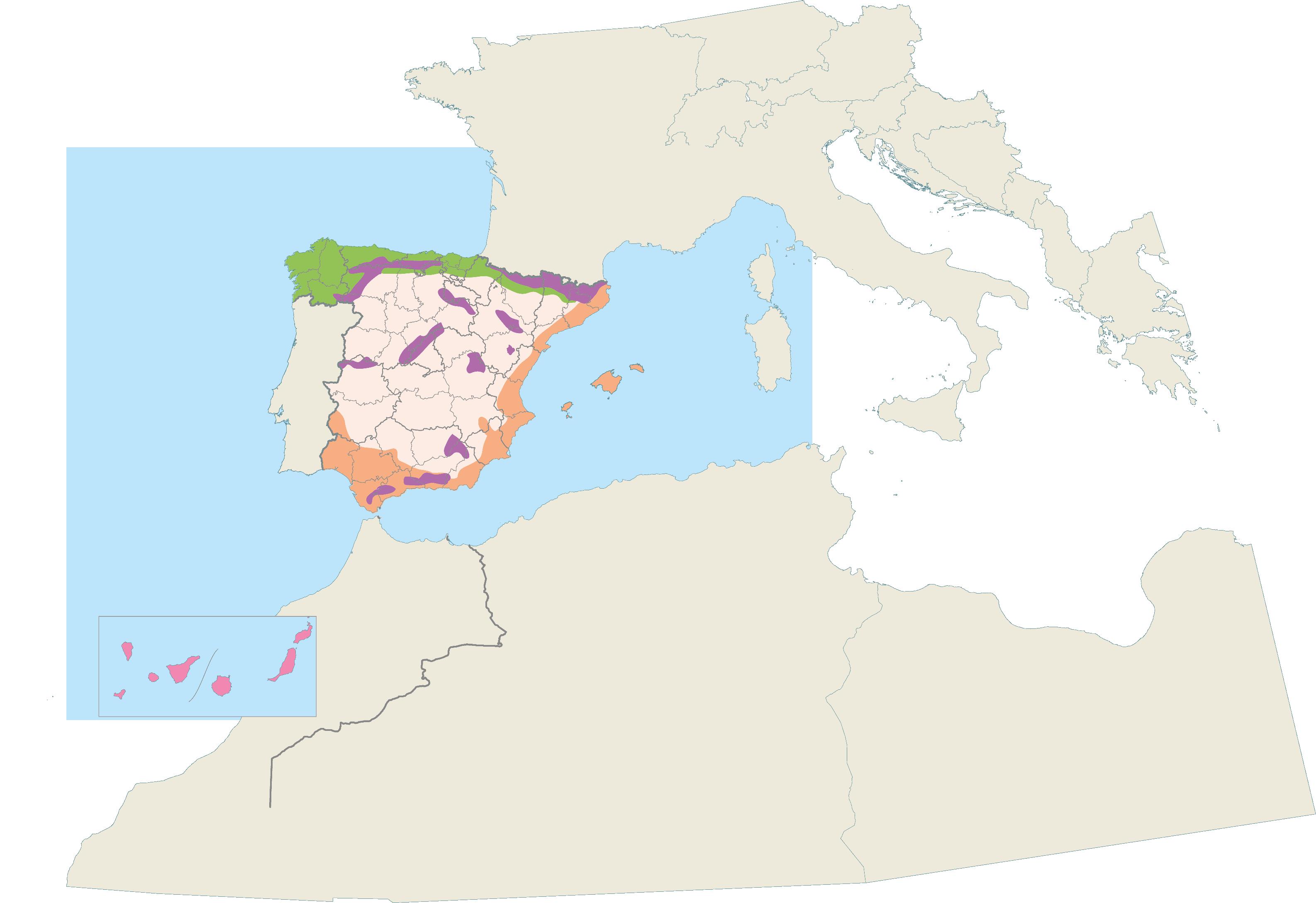
Landscapes
Landscape is an area of the earth's surface resulting from the interaction of the different factors present in it (climate, flora, fauna, relief, etc.) which can be observed together from a certain point.
As we saw in this unit, climatic factors mean that in some areas there are higher or lower temperatures, more or less rainfall, less or more humidity or altitude... All these factors, with the relief, flora and fauna, make up different climates, and different types of landscapes.
1 Match the characteristics of each type of landscape with its corresponding climate.
2 Using different types of paper, create a two-part map where the map of landscapes can be placed on top of the map of climates. For example, you can use cardboard for the climate map and tracing paper for the landscape map so that one can be placed on top of the other.
Let's prevent fires!

Do a search on the Civil Protection website and make a list of the measures you consider most important to prevent forest fires.


Transition landscape. This is found in continental and continental-Mediterranean climate zones. It has trees and combines deciduous and evergreen. These forests have adapted to the frequent droughts of the continental climate in the warm months.

18 5
ATLANTIC OCEAN ATLANTIC OCEAN 0 100 200 300 km
5
Oceanic landscape. Located in areas with an oceanic climate. This landscape has tall deciduous trees, such as oak and beech, which lose their leaves in autumn. This area of Spain is known as green Spain, as the vegetation is also green because of the abundance of precipitation.


Mountain landscape. This type of landscape is located from the upper limit of a forest to the top of a mountain. Vegetation is limited because of the climate of these areas and is mosses or small bushes.


Mediterranean landscape. This type of landscape is in areas with a Mediterranean climate. The vegetation is evergreen trees, such as pines and holm oaks, because of the irregular precipitation and high temperatures. The trees are not very tall, but the leaf cover is generally denser than in the Atlantic forest.
Take note!
The main causes of fires include climate change, lots of scrubland and poorly managed urbanisation of woodland areas.


Landscapes of Spain Ocean landscape Transition landscape Mediterranean landscape Canarian landscape Mountain landscape Oak eech Pine tree Chestnut Pine tree Holm oak Rockroseh Laurel Canary pine Palm heart Sabina
M e d i t e r r a n e a n S e a
Cantabrian Sea
2
4
Canarian landscape. located in the Canary Islands archipelago and is defined by the special features of the subtropical climate. Canary laurel forests are in the humid subtropical zone and in the more arid areas the Canary palm tree and the dragon tree are most important.
3 1
We study how the climate is changing
What GIT (or GIS) features can be useful when managing a forest fire?
Climate change
Climate change is a change in climate, because of human activity, that changes atmospheric composition, plus naturally occurring changes in the planet's climate.
Climate change Causes
• Increase in greenhouse gases, caused by activities that use fossil fuels: transport, heating, factories, etc.

• Deforestation, or destruction of forests, which limits nature's ability to absorb carbon dioxide.
• Excessive consumption by the population. Our lifestyles have a major impact on the planet's health.
Speaking. Talk to a friend about the possible consequences of climate change if we don’t change our behaviour.
Writing. Write a list of possible actions we can do to reduce the negative consequences of climate change.
Consequences
• Increasing temperatures and fires.
• Devastating extreme weather events, such as floods or extreme droughts.
• Rising sea levels because of melting ice and warming water.
• More endangered species.
• Depletion of natural resources.
• More diseases and health problems.
Mitigation and adaptation measures

To combat climate change, reduce its negative consequences and benefit from the opportunities it can create, a series of measures have been put in place: Improving energy efficiency, focusing on renewable energies; reforesting forests; promoting public transport and sustainable mobility; and creating protocols for action for climate emergencies.
Effects on our community
Average temperatures have risen by almost two degrees in recent years.
Also, precipitation has changed, which is no longer as abundant or distributed seasonally in the same way. There are more droughts in the last five years, drought periods have increased over the last five years, and torrential rains are more frequent.
This has a direct impact on our landscapes.
20
6
Language Bank
GITs
Geographic information technologies (GIT) are a set of technologies that make it easier to collect, use and analyse environmental data the collection, use and analysis of environmental data, such as remote sensing (RS), global positioning systems (GPS) and geographic information systems (GIS).
These technologies use GPS to make maps of a specific area and connect them to the most relevant study aspects.
This makes it easier to analyse things such as precipitation, pollution levels and the relationships between them.
GIT in meteorology and climatology
Thanks to GIT, extreme meteorological phenomena such as hurricanes, torrential rains, etc. can be identified and prevented.

Maps are produced that predict the approximate risk level by adding hazard and social and economic factors in a specific territory.
GIT can also be used to collect data on climate change evolution, such as locating areas with abnormal temperatures, establishing how natural atmospheric processes affect global warming, creating predictive models of its consequences, etc.
1 I think, I’m interested, I investigate What is the relationship between climate change and the increase in fires in recent years?
2 Investigate how other activities that can use GIT. Which of these applications do you find most useful? Why do you think so? Discuss with your classmates.
3 Why are GIT useful for climatology and meteorology?
4 Search for information on cases where GIT has been used as a tool in fire containment or firefighting. Share the results of your search with the rest of the class.
Take note!
GIT has designed a 3D simulator that predicts how a fire will behave, which areas it will affect and where it will move. All this information is shown on a map, meaning we can make better decisions.
U1 21
W hat have I learned?
1 What are atmospheric phenomena? Explain them briefly.
2 What is meteorology? How is it useful for your daily life?
3 Classify these terms according to whether they are weather elements or factors:
Atmospheric pressure, sea influence, temperature, latitude, wind, humidity, precipitation, altitude, relief.
4 True or false?
a) Climographs can be made from one day to the next.
b) Climographs represent temperatures and precipitation.
c) Temperatures are represented by bars.
d) Climographs help us understand a place's climate.
5 Look at this climograph and correct the sentences in your notebook.
6 Copy and complete this table about the climates of Spain.
Temperatures Precipitation
a) The lowest temperatures were reached in August and September.
b) In February there was 40 mm of precipitation.
c) The wettest month of the year was April.
d) Only three months had temperatures above 20°
Oceanic
Continental
Mediterranean
Mountain
Subtropical
7 Explain how climate influences the landscape in your own words.
8 What type of landscape does each colour represent? Complete the map legend in your notebook.
9 Describe what these landscapes are like.
a) Oceanic.
b) Mediterranean.
c) Canarian.
10 What are GIT or GIS? Name three of their uses.
Traffic lights. Next to each activity, colour in your notebook like this:
if you knew the answer if you needed help
or if you did not know the answer
22 PORTFOLIO
0 80 160 200 40 120 0 10 20 30 40 Precipitation (mm) Santander Altitude: 15 m OCEANIC CLIMATE Annual average temperature: 13.9 ºC Total precipitation: 1 198 mm Temperature (ºC) Jan Feb Mar Apr May Jun Jul Aug Sep Nov Dec Oct Climatic
Spain ATLANTIC OCEAN ATLANTIC OCEAN Cantabrian Sea M e d i t e r r a n e a n S e a 0 100 200 300 km A B C D E
landscapes of
TARGET IN ACTION
Investigate, inform and give advice to prevent forest fires
1 Collect data for your research on the latest forest fires in our country using the I think, I’m interested, I investigate technique. Your research results will give you material to make an informative video about forest fires and give tips on how to prevent forest fires.

I think
I investigate I’m interested
H ow did I learn?
1 Have you learned anything new? What images do you remember? What did you like most about what you learned? How useful is what you have learned? How will it help you in your everyday life?
2 Reflect on what you can improve in the future and extend your reflection to what your classmates can improve.
Think about this!
What is the relationship between the areas most affected by fires and the types of climate?
Do you know if your autonomous community has an action plan to prevent and act effectively in case of forest fires?
How do you feel about almost all forest fires being caused by people?
As a citizen, what can you do to prevent a situation like the one in 2022 from happening?

U1 23
?
2 Is water undervalued ?
Carmen is a Spanish girl who studies 4th Grade Primary School in a class with other classmates. They did some research on the latest UNICEF reports for their group work. The report Carmen has found most interesting is a 2019 report on inequalities of access to water around the world. This report says approximately 2.2 billion people around the world do not have access to safe drinking water facilities. Also, this problem is increasing because of the rising pollution of freshwater sources. Sadly, children are the first to suffer the consequences of this situation.
What do you think?
What would happen if we suddenly had no drinking water in our homes and had to travel several kilometres to get it? Why do you think children suffer the most from these problems?

Context
In this unit...
Target in action
Make a sign with a catchy slogan to make people conscious of the importance of saving and not polluting our available water.
Follow the thread!
UNICEF says 1.8 billion people have gained access to safe drinking water since 2000, but there are large inequalities in accessibility, availability and quality of these facilities.

The hydrosphere
1
Where is water collected on our planet?
Groundwater and surface water
2
How is water divided up on Earth?
24
Rivers: elements and characteristics
3
What are rivers like?
Rivers in Spain
4
What are the most important rivers in Spain?
Responsible water use


5
Are we using water properly?
25 6
Where is water collected on our planet?
If water covers more than half of the earth's surface, why is access to it so limited in some countries?
The blue planet
Our planet looks blue when you look from space. This is because almost three quarters of the Earth's surface is covered by water, almost all of it is salty.
The hydrosphere is the Earth's water. Without it, life on Earth would be impossible.
• Humans, animals and plants need water to survive. Many living things live in it.
• The water in oceans and seas absorbs heat from the sun, helping to maintain and moderate the temperature of the planet.
Water can be found in nature in three states or forms: solid, liquid and gaseous. Water will change its state depending on how much cold or heat is applied.


Water states and its changes
Solid state
Language Bank

Speaking. In pairs, try to guess what you’re thinking about using the clues from the writing.
Writing. Imagine a place or object that has got water. Write some sentences to describe what it looks like.
To find a summary of the unit, watch the video 'Let me tell you' on anayaeducacion.es
To learn more about water, watch the video "The importance of water" on anayaeducacion.es.
Melting Evaporation
Liquid state
Gaseous state
Solidification
Condensation
26 1
Changing from a solid to a liquid because of the effect of heat.
Changing from a liquid to gaseous because of the effect of heat.
Water frozen by cold, such as snow or ice, is found in this way.
This is how water is found in seas, rivers or lakes. It is the most abundant.
This is what water is like when it is heated and turns into steam.
Changing from a liquid to a solid because of the effect of cold.
Changing from gaseous to a liquid because of the effect of cold.
The water cycle
Water is always moving around the Earth. Thanks to changes in its state, the water cycle takes place.
Condensation
As the water vapour rises, because of low temperatures, it condenses into small droplets that form clouds.
Take note!
Only 0.007% of the Earth's water is drinkable, and this amount is decreasing every year due to pollution.

Precipitation
As the clouds grow larger and larger, their weight and the drop in temperature cause the droplets to precipitate in the form of rain, snow or hail.
Evaporation
The liquid water present in the large bodies of water evaporates thanks to the heat of the sun and rises into the atmosphere in the form of water vapour.
1 Ideas pool Why is the Earth known as the blue planet? What is the hydrosphere?

2 Think and share in pairs Explain the importance of the hydrosphere.
3 Investigate at what temperature water melts and solidifies.
Accumulation
Water from precipitation accumulates again, forming bodies of water. Some of it filters down, forming groundwater, some of it stays on the surface, starting the water cycle all over again.

To better understand the water cycle, watch the video "The drop of water" on anayaeducacion.es.
4 Draw a diagram of the water cycle in your notebook.
5 Name the states of water and write what change is taking place in each case:
• Marina leaves the house and it starts to rain.
• Desiree and Juanlu are skating on a frozen lake.
U2 27
How is water divided up on Earth?
Which bodies of water do we extract the water we use daily?
Surface water and groundwater
The waters that make up the hydrosphere can be surface water or groundwater .
Surface water
Surface waters are those found on the earth's surface, resulting from the accumulation of precipitation or from the escape of groundwater to the surface. They can be inland or marine.

Marine waters are bodies of salt water, such as the seas and oceans. Two phenomena happen in them:
• Ocean currents. These are movements of water caused by changes in temperature and level of salt, by the wind or by the earth's rotation.
Inland waters are bodies of fresh water. They can be moving, as in rivers and streams, or still, as in lakes.
Groundwater
Groundwater is the water that cannot be seen. It is located below the surface of the earth. It filters through porous soils or cracks in rocks and accumulates in the earth's interior, forming aquifers and underground rivers.
• Tides. These are changes in sea level caused by the gravitational pull of the moon and the sun on the earth.
Sometimes they are extracted artificially by digging wells
These waters form underground caves and tunnels. Occasionally, they rise to the surface, creating to natural springs or fountains.

28 2
Less and less water is available!
Look at the graph, think and answer:
• What is the trend in the evolution of available water, is it increasing or decreasing?
• In which year was the highest amount recorded? And the lowest?
• How many years are there between the two dates?
• What is the approximate difference between the two?
Water usage
Humans use water for activities such as agriculture, livestock farming, industry, etc. We also use it for our own consumption (drinking, hygiene, food, cleaning, etc.).
Stored water
Dams are built on rivers to store fresh water in reservoirs to provide water when it is not raining and to produce electricity.

1 What two types of surface water are there?
2 Write two examples of bodies of fresh water and two examples of salt water.
3 What is the difference between groundwater and surface water?
Evolution of available water in Spain
drinkable For its puri cation
Seawater treatment may be a solution to the increased lack of freshwater, but its economic and energy costs are too high for it to be a cost-effective solution.
Before it can be used for human consumption, water must be treated, which is why desalination and purification processes are carried out.
4 1-2-4 List the main activities in your daily life that require the use of water. Where do you think it comes from?
5 Investigate and explain what desalination and water purification are.
U2 29
Not
Sourcce: INE, www.epdata.es
7 000 000 6 000 000 5 000 000 4 000 000 3 000 000 2 000 000 1 000 000 0 200020012002200320042005200620072008200920102011201220132014 2016 2020 2018 m3 (Thousands) Reservoir Dam
Take
note!
What are rivers like?
Do humans benefit from the features and elements of rivers?

What is a river?
A river is a freshwater stream made by precipitation or snowmelt that starts in the mountains and flows into the sea, a lake or another river.
Elements of a river
We can distinguish different parts or elements of a river: source, course and mouth
Source. Place where a river starts or springs. It is normally in mountainous areas.

Upper course. The section closest to the source. The waters flow very fast because of the gradient.
Course. The course of the river from its source to its mouth. We divide it into the upper, middle and lower course.
Middle course. The central section of the course. The gradient decreases and the speed of the water decreases.
Tributary. River that flows into another river.
Lower course. The section closest to the mouth of the river. There is hardly any gradient and the water flows slowly. The river forms very sharp bends, called meanders
30 3
Riverbed. The land where a river flows.
Watershed. Set of lands whose rivers flow into the same sea or ocean.
Characteristics of a river
The main characteristics of a river are length , flow and regime
These characteristics depend on two factors : relief , which determines the length and velocity of the water, and climate , which determines the flow and regime.
1 List the elements of a river.
2 In your notebook, define these concepts: tributary, riverbed, mouth and flow .
3 Do you know if there are any reservoirs
The waters around me
Look for information and make a list of the bodies of freshwater in your area.
It does not need to be only rivers, but also lakes, ponds, aquifers, etc.
Length. The distance from the source to the mouth of the river. Rivers can be short or long.
4 Classify these terms according to whether they are elements or characteristics of a river: regime - course - mouth - flowsource - length.
Flow. The amount of water that the river carries during a particular section and at a particular time.
Regime. Variation of the flow throughout the year. Regular regime if it varies little; irregular regime if it varies a lot, or even dries up.
Mouth. The final section of a river. Its waters flow into a sea, ocean, lake or another river.

U2 31
More than 80% of the wastewater resulting from human activities is discharged into rivers or the sea without any treatment, resulting in pollution.
Take note!
What are the most important rivers in Spain?
How well preserved are Spanish rivers?
The three watersheds
Spain is divided into three hydrographic watersheds : the Cantabrian watershed, the Atlantic watershed and the Mediterranean watershed.


These are rivers that flow into the Atlantic Ocean, which are the majority because of the gentle westward slope of the Central Plateau. We have two groups:
- Galician rivers They are short and regular. The most important are the Tambre, the Miño and its tributary, the Sil
- Rivers of the Meseta and the Guadalquivir depression. These are long and irregular rivers. The main ones are the Duero and the Tajo , the Guadiana and the Guadalquivir
There are no permanent rivers in the Canary archipelago. When it rains in storms, the water flows in channels known as ravines
To better understand landforms, watch the video "The rivers of Spain” on anayaeducacion.es.
Rivers in Spain
River that ows into the Cantabrian Sea River that ows into the Atlantic Ocean River that ows into the Mediterranean Sea Archipelagos
River
Tributary
Torrents and ravines
Country boundaries
32 4
Tambre MIÑO E s l a DUERO DUERO Tormes TAJO GUADIANA Genil Pisuerg a Alberche GUADALQUIVIR Sil Tinto Odiel Nalón ENavia o Besaya Narcea dauG a lhorce Cantabrian
ATLANTIC OCEAN
Ceuta MOROCCO PORTUGAL CORDILLERA CANTÁBRI CORDIL S I STEMA C
ATLANTIC OCEAN ISLAS CANARIAS
The Atlantic watershed
Rivers that flow into the Cantabrian Sea They are short rivers, as they start very close to the sea, in the Cantabrian mountain range. Thanks to the rainy climate, they are regular rivers. The main ones, from east to west, are the Bidasoa, the Nervión, the Besaya, the Nalón, the Navia and the Eo
1 How many watersheds are there in Spain? Draw a map of Spain and point out the main rivers in each one.
2 In pairs, play a game where you say the name of a river out loud. Your partner has to guess which watershed it belongs to.
3 Look at the map and write down: two tributaries of the Duero, one of the Tajo, one of the Guadiana, one of the Guadalquivir and two of the Ebro.
4 Draw up a diagram or conceptual map with the basic information about the rivers of Spain.
They are rivers with different lengths and regimes. There are two groups:
- Eastern rivers. From north to south, the main ones are the Ter; the Llobregat; the Ebro , which is the largest in Spain; the Turia ; the Júcar and the Segura
- Southern rivers. These are short, as they start near the coast, in the Penibetic mountain range. The most important are found in Andalucía and are, from east to west, the Almanzora, the Guadalfeo and the Guadalhorce
There are no permanent rivers in the Balearic archipelago either. When there are strong storms, streams called torrents are formed.
Take note!
Are we taking care of our rivers?
Think with a partner 3 eveyday actions we can take to prevent river pollution.
More than half of Spain's rivers are polluted, because of toxic fertilisers or chemicals. There are also other more common pollutants, such as household appliances, masks, furniture or debris.
U2 33 J a r a m a GUADIANA Cigüela TAJO Jabalón Bidasoa Nervión SEGURA Ter L l o b r e gat Segre G á l l e g o Aragón Cabriel JÚCAR EBRO TURIA Jalón EBRO Guadalfeo Almanzora Sea M e d i t e r r a n e a n S e a ISLAS
Melilla FRANCE ALGERIA ANDORRA CA SISTEMA IBÉRI C O LLERASBÉTICAS P Y R E N E E S CENTRAL 0 100 200 300 km
BALEARES
The Cantabrian watershed
Rivers that flow into the Mediterranean Sea
The Mediterranean watershed
Are we using water correctly?
Is it the responsibility of all citizens to care for water and use it correctly?
Water is essential for the life of all living things on the planet. Apart from drinking, people use water for many other activities.
This natural resource may seem unlimited to us, but not using it correctly or over-consumption could lead to its drying up and have very negative consequences. So, it is very important that we use water intelligently.
Uses of water
When we use water to clean streets, fill public fountains, water parks and gardens or put out fires, we are making a public use of it, as it is used for the benefit of all citizens in general.

Who consumes less water?
Look at the graph and answer:
• Which autonomous community spent the most water in 2020?
• Which autonomous community had the lowest consumption in 2020? Why do you think this is?
• Which number is closest to your region's consumption in 2020?
Language Bank
Speaking. Go over the tips for saving water with a friend and say which ones you like.

Writing. Organise the tips into two groups: the ones you like and the ones you don’t. Write a sentence explaining why.
When we use water at home, we are using it for domestic purposes, for example, when we drink, take a shower, brush our teeth, wash dishes and clothes, etc.
34 5
200 180 160 140 120 100 80 60 40 20 0 litre/inhabitant (Units) C.ValencianaCantabriaRegióndeMurciaCastillayLeónAsturiasCanariasCastillalaManchaEspañaAragónAndalucíaExtremaduraGaliciaMadridCataluñaIslasBalearesCeutayMelillaLaRiojaNavarraPaísVasco 2018 2020 Source: INE, www.epdata.es Average household consumption by region
Public use Domestic use
Water saving tips
Instead of taking a bath, take a shower. Remember to turn off the tap while applying soap.
Run the washing machine and dishwasher only when they are completely full.

Don't leave the tap running while soaping the dishes. Use less detergent to pollute less.

Turn off the tap when brushing your teeth.

1 What two uses do people make of water?
2
Before I thought, now I think Your local environmental council has asked all local schools to submit ideas on how to improve the public's use of water. Write a letter to the councillor explaining four ideas and why they would be beneficial to your local area.
3 Think about the water saving tips and complete this table in your notebook. What aspects of your daily life do you think you could improve? Could you help your family to follow these tips too?
Tips I always do it
I sometimes do it I never do it ? ? ? ?
Use glasses or bottles for drinking. Do not pour directly from the tap.
To better understand how to save water, watch the video "Domestic uses of water" on anayaeducacion. es.

Take note!
Women and girls are responsible for collecting water in 8 out of 10 households without access to piped water.
U2 35
Use bath water to mop the floor.
W hat have I learned?
1 List three reasons why the hydrosphere is important to humans.
2 Copy and complete the diagram.
5 Draw a picture of the water cycle showing each of the parts with a brief explanation.
6 Copy and complete the crossword puzzle about the elements and characteristics of a river.
3 Find the error in these sentences and correct it.
a) Groundwater can be either inland or marine.
b) Rivers, lakes and oceans are examples of inland waters.


c) Marine waters are bodies of fresh water.
d) Tides are movements of the waters of seas and oceans caused by changes in temperature and salinity, by wind or by the Earth's rotation.
4 Look at the images and say to which part of the course of a river each one belongs.
Across: 1. The land through which a river flows. 2. The final section of a river. 3. The course of the river from its source to its mouth.
Down: 4. Variation of the flow throughout the year. 5. The distance from the source to the mouth of the river.
7 Identify the river marked by each number.
36 PORTFOLIO
1 2
4 5
3
A C B Solidification ? ? Liquid ? Evaporation ? 1 2 3 4 5 6 7 8
TARGET IN ACTION
Awareness of the importance of water
1 Reflect on the negative effects that our everyday actions can have on water using the Consequences and Results (C&R) thinking technique. These reflections will provide you with ideas for your banner slogan to raise awareness about the good use and care of water.
If you do something (play, do sport, rest, share, wrap up warm, eat sweets, don't wrap up warm)...
Long-term
What is likely to happen? What consequences will it have? What will be the resullts?
For you ?
For others
- Peers: for classmates, friends, brothers and sisters...
- Adults: for teachers, parents, grandparents...
Short-term

What is likely to happen? What consequences will it have? What will be the resullts?
For you ?
H ow did I learn?
1 Have you learned anything new? What images do you remember? What did you like most about what you learned? How useful is what you have learned? How will it help you in your everyday life?
2 Reflect on what you can improve in the future and extend your reflection to what your classmates can improve.
For others
- Peers: for classmates, friends, brothers and sisters...
- Adults: for teachers, parents, grandparents...
Think about this!
Do you think it is fair that some people have access to clean water and others do not?
Who do you think is to blame for this situation? Would it be the same people who could find a solution?
What do you think will happen in 50 years' time if drinking water supplies continue to decline and we continue to pollute them?
U2 37
C&R
All rights reserved. No part of this publication may be reproduced, stored in a retrieval system, or transmitted, in any form or by any means, electronic, mechanical, photocopying, recording, or otherwise, without the prior permission of the publishers.
© GRUPO ANAYA, S.A., 2023 - C/ Valentín Beato, 21 - 28037 Madrid.
