ACTION PLAN
OCTOBER, 2018


Alan
Dave


OCTOBER, 2018
Alan
Dave
The mission of the Warehouse Arts District/Deuces Live Joint Action Plan is to identify specific opportunities for enhancement of public realm infrastructure that can support the upward social, cultural and economic potential of the areas. This Action Plan identifies Basic Infrastructure (sidewalks, street trees, lighting, etc.), Progressive Steps (streetscapes, road diets, bike lanes, etc.) and Transformational Projects (signature parks and streets) that are responsive to the opportunities of individual places, while working to create a more unified, consistent infrastructure for the overall region. The plan also identifies opportunities for collaboration between private property and public realm to create shared solutions which may benefit multiple properties and a more unified sense of place and urban function.
The Joint Action Plan is the result of extensive collaboration between the City of St. Petersburg City staff and the Deuces Live Main Street (Deuces Live) and Warehouse Arts District (WADA). This participation included extensive input, ideas, and review by residents, business, and property owners as well as the formal participation of the boards of directors of Deuces Live and WADA in joint committee work sessions. Plan ideas were reviewed and vetted by members of City Staff, including planning, transportation, public works, and economic development.
The work began in the fall of 2016 with a specific “Part 1”: Issues and Opportunities Report (dated May 2017) documenting the extensive community participation process and providing a strategic planning framework of Guiding Principles and preliminary ideas to inform detail design. This Action Plan may be viewed as a “Part 2”: detail design recommendations completed during the autumn of 2017 as a direct result of the Part 1 effort and a seamless continuation of the community discussion.
This Action Plan builds upon the Issues and Opportunities Report, and particularly works to activate a strategic framework of Guiding Principles confirmed by the community, which set the philosophy for detailed design recommendations:
1. Define the Character Areas: Mission and Identity
2. Connect the Community Places: Safety and Connectivity
3. Create an Urban Environment for People: Urban Form and Place
4. Facilitate Positive Investment & Reclaim Places: Renewal and Redevelopment
5. Position for New Forms of Success: People and Partnerships
The balance of this document is intended to describe an organized program of recommended improvements within the WADA/Deuces Joint Planning District with drawings and budgeting figures to allow the City and Community to plan for a phased approach to public investment over time. It is important to note the ideas are detailed at a schematic level. As new opportunities arise, the priority of one project over another may change, and in some cases, the detail design approach may be adjusted. However, the plans and diagrams in this Action Plan are intended to provide unifying guidance to ensure that each measure of investment can maintain a consistent general design approach—a compass to guide future decisions.


The Warehouse Arts District/Deuces Live Joint Action Plan covers a very large, diverse, and interesting area of south St. Petersburg—rich with arts, cultural history and dynamic pockets of disinvestment and emergent reinvestment.
The planning area is centered on the historic industrial, commercial, and neighborhood areas associated with the rail/shipping industry that is now redefined as the Pinellas Trail corridor. This was once an area of heavy employment based upon industry and rail access, which effectively supported local resident income and main street business and community services. Today, without the rail, the area has suffered from loss of employment, and property is repositioning.
The opportunity now is to develop new forms of community and economic activity based on emergent uses and needs—reinventing the area as a place for renewed opportunity and quality of life. The patterns of “Main Street” include interesting new businesses, and the Warehouse Arts area is experiencing an influx of dynamic new users who are taking advantage of the large lot/industrial building patterns. However, the prior industrial land uses and past planning sensibilities have left a legacy of frayed or inconsistent infrastructure, such as basic lighting, sidewalks, street trees and other amenities that are conducive to new investment to meet the needs of all users and visitors for a more livable, walkable, attractive environment.
The geography stretches along the 22nd Avenue South corridor from 1st Street South to 18th Avenue South and across the industrial areas north of I-275. The subject property primarily includes the areas of non-residential zoning: industrial, commercial, mixed use areas. This is not a “neighborhood plan”. However, in looking at the local business patterns of the Deuces Live Main Street and the emergent business patterns of the WADA, consideration of adjacent community patterns and places within the larger city was clearly a consideration.
The challenge is completing a plan for small-lot, traditional Main Street retail and community services within the same framework as large-lot, transitioning Industrial, Arts, and Light Manufacturing as seen in WADA. Fortunately, the goals of a connected environment with opportunities for specific feature investment places allows for continuity of ideas. Recommended Actions can be both specific to individual places, while guided by a consistent set of ideas, that if implemented across the study area, will result in a more unified, livable, and active place.


The WADA and Deuces Live Main Street are composed of a wide array of buildings and forms. However, there are a few consistent themes: an expressive, culturally rich pattern of buildings and businesses, a harsh and inconsistent public realm infrastructure, and opportunity for buildings to better relate to the public realm if a more walkable, livable infrastructure were present. This is an urban area composed of special places —each with significant potential for cultural, community and economic success.


The approach to the planning effort was to work in detail with the community, specific stakeholders, a joint planning committee and City staff to develop an Action Plan that is based on agreed-upon goals and desired opportunities for change. This was accomplished by continuous involvement and validation at each step in the process, multiple public workshops and continuous on-line presence. The centerpiece of the plan are strategic Guiding Principles that respond to underlying community concerns and resultant Forward Moves that put ideas into action in high priority places.
Project Implementation recognizes that some actions involve Basic Infrastructure which often times are less expensive, but broadly needed across the study area. Progressive Investments and Transformational Opportunities are generally more targeted and may be more costly, but provide significant paradigm shifts in the use and function of the area. Over time, a program of phased, prioritized improvements may include a sampling of projects at all three levels to meet community need.
Joint Steering Committee Meetings
Public Meetings
Trolley Tour
Stakeholder Meetings
Citizen Photography Exercise
Design Studio Workshop
Online Engagement
& IDENTITY
SAFETY & CONNECTIVITY
URBAN FORM & PLACES
RENEW & REDEVELOP
THE METHODS OF PUBLIC ENGAGEMENT WERE DESIGNED TO MAKE THE PLANNING TEAM ACCESSIBLE AND TO BUILD TRUST – AS WELL AS HONEST AND MUTUAL INTEREST IN SHARED SUCCESS – BY MEETING PEOPLE WHERE THEY LIVE AND DO BUSINESS.
The methods of public engagement were designed to “dive deep” into the area with as many people and through as many methodologies as reasonably possible. This approach was designed to make the planning team accessible and to build trust—as well as honest and mutual interest in shared success—by using diverse techniques, such as large meetings, small focus groups, walking tours, and on-line engagement.
We conducted over 15 stakeholder small group meetings, several individual meetings, and several business “drop-ins” to speak with people directly—in addition to our more structured, large public events. This enabled the planning team to not only interact with many constituents, but also pose questions and gain input in different ways, allowing for a deeper layering of the input because we could hear the commonality in issues through different voices and techniques.
In response to the diverse geographies and planning topics, we worked formally with a combined Joint Planning Committee (JPC) representing both Deuces Live, the Warehouse Arts District Association (WADA), and specific sub-committees associated with the individual groups with some cross representation. Altogether, the approach allowed for several tiers of interaction, including the:
• Core Team (Consultant and City PM)
• Joint Planning Committee (JPC) with Deuces Live and WADA Representation
• Supportive Sub-committees, One Each for Deuces Live and WADA
• Stakeholders Representing Key Properties, Local Institutional Entities, and Businesses
• General Public: Residents and Property Owners
Project Kick-Off Meeting
November 30, 2016
Trolley Tour
December 1, 2016
Stakeholder Meetings
January/November 2017
Deuces Live Community Meeting
January 12, 2017
Citizen Photography Exercise
January 23, 2017
4 Day Design Studio Workshop
January 31 to February 2, 2017
Public Meeting 1 October 11, 2017
Public Meeting 2 December 7, 2017
Joint Planning Committee Meetings
November 2016 - August 2018
City Staff and Coordination Meeting November 2016 - August 2018
Online Engagement
November 2016 - December 2017


THE VISION DESCRIBES THE FUTURE OF THE DEUCES LIVE AND WAREHOUSE ARTS DISTRICT. IT IS INTENDED TO BE ASPIRATIONAL AND BROAD, SETTING THE COURSE FOR THE FUTURE.

Rediscover a new role that relates to the neighborhood and employment base, featuring an authentic culture and cuisine experience for visitors and community services for locals.
Reposition the area for a new employment focus that includes light manufacturing and commercial uses, featuring a walkable industry and art experience for visitors, as well as adequate infrastructure.
THESE PRINCIPLES GUIDE THE ACTION PLAN. THEY ARE THE UMBRELLA UNDER WHICH FRAMEWORKS AND SPECIFIC ACTION & PROJECTS HAVE BEEN DEVELOPED. THESE PRINCIPLES ARE INTENDED TO REMAIN CONSTANT, PROVIDING A BASELINE FOR NEW FRAMEWORKS TO BE DEVELOPED AND THE ACTION PLAN TO EVOLVE TO MEET CHANGING CONDITIONS AS TIME GOES ON.
Roles Within the Region
Link
Signage and Wayfinding
The subareas within the 22nd Street Corridor, the Warehouse Arts District, and the Deuces Live Main Street provide numerous opportunities to brand the area, while also responding uniquely to the specific histories and new activities across this diverse planning area. This will allow for the creation of specific places within the community that are valuable and meaningful for local businesses and residents—and also interesting and attractive for outside visitors to patronize the businesses and appreciate the history and character of this unique area of St. Petersburg.


Today, the WADA and the 22nd Street Corridor are defined by a mix of residential streets: a few expanded for industrial traffic, some disconnected from the city grid, and many with incomplete basic infrastructure. This may be reasonable for a single use industrial area, but the District and Corridor are transitioning into places that are more mixed use and are becoming attractors for outside visitors.
Similarly, the Deuces Live Main Street, while designed at a smaller scale, also has functional and character-based limitations necessary to support an active main street.


Over time, it is important that the streets evolve into more multi-dimensional public realm facilities with better bike, pedestrian, lighting, parking, wayfinding, landscape, and other “character” elements that can support districts not only for local investment, but visitor exploration and comfort as they explore “working” industry and main street environments. In some cases, particularly, in the WADA, it would be helpful for new connections to be made, in order to provide new vehicular and walking access to properties which are currently in very large formats that must be “circumnavigated” to get from one place to the other.
Part of creating an environment for people to visit the Corridor, District, and Main Street relates to more livable, multi-modal, walkable, attractive, and connected streets. However, the streets must be addressed by buildings that are interesting and active at the street level. The goal is an animated, humanized environment that rewards walking activity with a sense of safety as well as new and interesting things to see every 8 to 12 seconds. The Deuces has many of these types of buildings, but some can be spruced up with paint, facade/awning enhancements and, ultimately, reinvestment in existing or new businesses.
The Warehouse Arts area has nearly the opposite issues. New business investment is coming at a rapid rate. However, the actual building stock is naturally monolithic and oriented away from the street as one would expect in a historic industrial shipping yard. To move forward with a more entrepreneurial, arts, and neighborhood-oriented economy (while still supporting industry), it is important that walls and barriers of these large buildings are broken down with windows, doors, and orientation toward an animated streetfront interface designed to engage people.


Ultimately, the challenge and the goal is new business investment that can fill in the many vacant parcels and underutilized buildings. This requires local business support, quality products (some of the new restaurant offerings), development/lending assistance, and addressing structural problems such as parking and the surrounding disinvested neighborhoods. This also requires an “attitude toward invitation.” The retail will be successful if it positions itself as a place not only for locals who want to explore authentic, interesting places.


Beyond the economic development needs, there is also a need to re-purpose certain key sites or services. One strategically important example may be the Royal Theater, perhaps the most significant piece of cultural architecture in the area. Today, the Royal Theater is home to the Boys and Girls Club, which is constrained in how many children it can support in this facility—and the building is not conducive to the needs of the Neighborhood children. Meanwhile, few investments could be more symbolically and materially emblematic of the renewal of the spirit of the neighborhood than if the Royal Theater was returned to an operating theater and community events space.
The WADA and Deuces must work together, as well as work within their own constituency. The input process revealed great hope and a strong spirit of pride for the history and future of the Deuces Live and the emergent opportunities for WADA. As both organizations look to move forward to address current challenges and opportunities, there is a stronger need for alignment.
As community organizations, leadership is naturally grassroots and heavily supported by volunteer efforts. This makes the places authentic and allows the neighborhoods to determine their own destiny. However, in both the District and the Main Street, there are multiple voices that are sometimes competing and occasionally at odds.
Going forward, it will be important for the available leadership and volunteer resources to be aligned. Fortunately, there are many defined leadership groups, institutional entities, and stakeholders who are active in each area, but they all have limited time and resources. There are opportunities to better define the role of each sub-group organization and to work together in order to respect roles and mutual needs. There simply aren’t enough volunteer resources available, and there are too many things to do. This planning process is beginning to uncover areas of conflict and also opportunities for clarified mission definition and vision alignment.
Confirm the “Hook” for Locals and Visitors Building Enhancement Parking for Events and Redevelopment
Rediscover the Historic Buildings
Leverage Your Culture, Schools, and Programs
Linked Strategies for City and Private Sites
Align Organization to Work Together:
• Mission and Goals
• Marketing Strategies
• Events
Build Physical Infrastructure
Define and Activate the Sub-Districts
Large Lot Infill Opportunities
Reorient: Street/Trail Oriented Buildings
Build on Art Walk with New Outdoor Events


FORWARD MOVES ARE THE PROJECT INITIATIVES THAT ORGANIZE THE ACTIONS OF THE PLAN. THE RECOMMENDATIONS ARE CONCEPTUAL AND WILL REQUIRE REFINEMENT AND ADDITIONAL DUE DILIGENCE UPON IMPLEMENTATION. HOWEVER, EACH OF THE IDEAS IS CONSIDERED BOTH ACTIONABLE AND ACHIEVABLE. THE SPECIFIC ACTIONS AND INDIVIDUAL PROJECTS ARE ORGANIZED BY IMPLEMENTATION TYPE AND PROVIDED WITH A BUDGET VALUE.
Infill sidewalks, crosswalks, lighting, street trees, and other basic infrastructure for a safe, contiguous walking environment. Actions include:
• Develop a transit and bicycle network framework
• Develop a street network framework
• Create streescape design standards
• Improve key streets and intersections
• Reclaim and preserve underdeveloped streets
• Preserve and improve the alleys
• Create design standards for future redevelopment sites


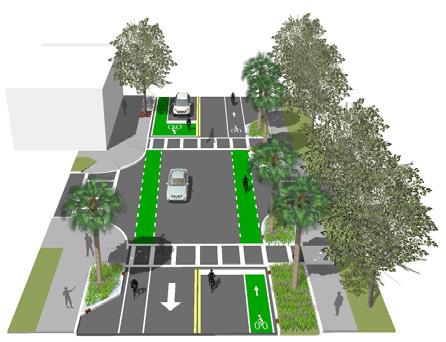
Invest in the two connecting corridors as places for dedicated bike facilities, more generous pedestrian walks, branded crosswalks, street trees, on-street parking, and lighting. Actions include:
• Transform 5th Avenue South to a complete street
• Re-design 22nd Street South

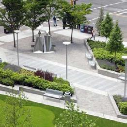
Develop signature park spaces in both WADA and Deuces that leverage key intersection locations and proximity to local business for dedicated small festival and community event space. Actions include:
• Build new parks
• Create opportunities for new private/public open space
• Create opportunities for parklets and pop-up parks
• Event streets
Incorporate and encourage interesting and unique expressions of art in the design of gateways, parks, and street infrastructure. Actions include:
• Use special graphic motifs on key crosswalk and intersections
• Keep using the murals as a trademark feature of the area
• Encourage the use of art elements
• Allow the use of business pedestrian signs
• Transform the Dome signs into art elements


Enhance the appearance of the corridor with art, trees, and lighting, and leverage the potential relationships of businesses along the trail with front doors and active patio spaces that can be accessed from the trail. Actions include:
• Design the trail as the new district destination
• Encourage access to the trail from buildings
• Orient the buildings toward the trail
• Improve trail crossings
• Design a wayfinding system for the trail


Design both public and private activity areas that can be used in many types of ways, supporting diverse event types and fostering an interface between public space and private business activity. Actions include:
• Connect destinations and create new distinct character areas and address
• Develop adequate parcel and block infrastructure to allow future redevelopment
• Create a Building Facade and Site Improvement program
• Identify and acquire potential site for redevelopment, open space and/or housing
• Create partnerships with local institutions
• Develop a task force for long-term project implementation

Both WADA and Deuces Live Main Street can be places with linked, connected urban streets that are conducive to a safe walking environment. This connected infrastructure includes targeted improvements and connective infill of sidewalks, crosswalks, lighting, street trees and on-street parking to make fully functional streets for basic retail activity, and event connectivity across complex areas with varied businesses.
This is intended to complete the streets as ‘linkages’ through areas of the WADA and Deuces which may have vibrant businesses adjacent to underutilized or ‘hard industrial’ sites so that visitors to the area can more easily navigate and access the interesting places within each area.
Develop a transit & bicycle network framework
Create continuous bicycle corridors on 5th Avenue South and 22nd Avenue South. Explore transit service expansion on 22nd Street South. Ensure that the area can be easily and safely navigated from transit to bike to walking without gaps in service by providing connections to the future Bus Rapid Transit (BRT) service at 1st Avenues North and South.
Develop a street network framework
Where possible, connect streets to allow for linkage across the District and easy “permeability” and access for pedestrians, bicycles and slow moving traffic as appropriate.
Create streetscape design standards
Unify the streetscape materials to create a cohesive appearance of the physical environment.
Improve key streets and intersections
Feature the key streets and intersections as opportunities to enhance safety as well as “brand” the district so that these locations will enhance the sense of place within areas of diverse private property appearance.
Reclaim and preserved underdeveloped streets
Take advantage of underutilized rights of way such as at 23rd Street South and 6th Avenue South to create functional streets that improve property access and district connectivity to neighboring properties and to the Pinellas Trail.
Preserve and improve the alleys
Utilize alleys not only for “back of house” service and access to parking, but also as navigable pedestrian paseo opportunities and pop-up event space in strategic locations.
Create design standards for future redevelopment sites
Require future development to appropriately addresses the street/public realm (and Trail) with front door and transparent windows as appropriate; provides supportive sidewalk easements where needed and leverages other opportunities for art and outdoor activity space.
Highlighted in blue are the existing sidewalks in the Warehouse Arts District. To be able to complete the walkable infrastructure new sidewalks and crosswalks need to be built and added, as shown in yellow.


This framework is a guideline to provide a comprehensive understanding of the role of the streets, existing and future improvements. Below are the elements and opportunities of the framework.
NOTE: Proposed traffic control devices will require further evaluation prior to any implementation.
NEIGHBORHOOD COLLECTOR: Complete streets that support vehicular, bike, transit, and pedestrian connectivity; provide access to the local street network; and have a target speed of 25-30 mph. These are type “A” streets with high level of care and finish; are primary pedestrian and bicycle linkages; and should have active building frontages.
LOCAL: These are low speed (20-25 mph) streets that should be retrofitted or reconstructed to support safe pedestrian and bicycle activities, such as improved sidewalks, streetscapes, and crosswalks.
FEATURE STREETS: These are new address streets to be built through redevelopment. They are pedestrian-priority streets that would contribute to the vision and character of the area, supporting new businesses, jobs, and housing. These streets are 23rd Street S and the segment of 22nd Street S from 9th Avenue S to 11th Avenue S (Deuces Live Main Street Core).
ALLEYS: These are narrow passageways that provide secondary access to buildings. Alleys contribute to the vehicular, pedestrian, and bicycle connectivity of the area, and they all should be preserved and improved.
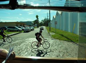
PINELLAS TRAIL: Pathway that transects the district for cyclists and pedestrians. The trail should be featured as the green recreational spine of the area. Improvements to the trail include street trees, lighting, and rest areas.
PROPOSED BICYCLE CONNECTION: We recommend to run a bicycle connection behind the Pinellas County Job Corps from the intersection of 5th Avenue S/20th Street S and the intersection of 22nd Street S/Fairfield Avenue.
PSTA BUS ROUTES: Exiting bus routes are managed by the Pinellas Suncoast Transit Authority. Adequate bus stops and shelter should be provided on 5th Avenue S.
22nd STREET S PROPOSED BUS ROUTES: We encourage the creation of a bus route along the 22nd Street South corridor to improve the connectivity and access of the area.
BRT STOPS: Future Bus Rapid Transit (BRT) platforms will be located on 1st Avenue N and 1st Avenue S. We encourage to locate trolley stops and new bike-share stations next to the platform to improve the pedestrian and bicycle connectivity of the area.
SIGNALIZED INTERSECTIONS: The signalized intersections will increasingly serve as the principal pedestrian crossing for pedestrian and bicycles.
ENHANCED PEDESTRIAN CROSSWALKS: These intersections will serve as safe pedestrian crossings for pedestrians and cyclists. New crosswalks should be added to each of them.
2 WAY STOP INTERSECTIONS: These intersections will serve as safe pedestrian crossings for pedestrians and cyclists. New crosswalks and bicycle box markings should be added to each of them.
TRAIL INTERSECTIONS: These are intersections designed to provide safe bicycle and pedestrian crossings for trail users. All trail intersections should have well-defined markings and signs.
EXISTING TROLLEY STOPS: These are the locations of the existing trolley stops for the 2nd Saturday Art Walk.
PROPOSED TROLLEY STOPS: Current stops are located in front of key businesses and galleries. As both areas grow, a demand for trolley stops will increase. We recommend to locate future stops on key intersections and next to transit stops. These will encourage visitors to visit the district without their cars.
EXISTING BIKE SHARE STATIONS: There are two bike share stations in the area, both located in key intersections.
PROPOSED BIKE SHARE STATIONS: Future bike share stops should be located next to transit stops to help promote the bicycle and pedestrian connectivity of the area.
Improve and re-design key streets and intersections in the Warehouse Arts District. Provide basic improvements such as:
• Sidewalks, Driveways, and Curbs
• On-Street Parking
• Lighting
• Street Trees and Planters
• Crosswalks
to the

Sidewalks, Driveways & Curbs
Planting Strip
Planter/Stormwater
Alleys - Permeable Paver or Reclaimed Brick
On-Street Parking
Palm Tree
Street Tree
Street Tree on Grates
The landscape palette selected for WADA streets are a combination of native and ornamental plants. We encourage the use of low impact development (LID) such as stormwater planters. By implementing LID principles and practices, water can be managed in a way that reduces the impact of built areas and promotes the natural movement of water within an ecosystem or watershed. Contemporary street furniture design and materials such as concrete, metal an iron were selected.
NOTE: These aesthetic palette applies to the new streetscape improvements.


PEDESTRIAN LIGHT FIXTURES DUKE ENERGY SHOEBOX PEDESTRIAN LED


DUKE
Transform the right-of-way of 23rd Street South into a feature shared street. This new street is a space for pedestrians, bicycles, and limited vehicular circulation. Paseo 23 will be a new address for the Warehouse Arts District that will boost future redevelopment, and will improve connectivity and access to business from the trail. Special events, such as festivals, small concerts, and art sales can happen on this new feature street.


This is a two lane street with 40’ from curb to curb, which allows the opportunity to provide on-street parking. There is no sidewalk, street trees or lighting infrastructure. Proposed basic improvements are:
• Sidewalks
• Street Trees
• Street Lighting
• Bike Racks
• Planters
• On-Street Parking
• Crosswalks
NOTE: These recommendations are conceptual and will require refinement and additional due diligence upon implementation.


This is a two lane street with 27’ from curb to curb, which allows the opportunity to provide 7’ wide on-street parking on the east side of the street. Sidewalks and street trees are inconsistent along the street. (See Option A)
Proposed basic improvements are:
• Sidewalks
• Street Trees
• Street Lighting
• Bike Racks
• Planters
• On-Street Parking Markings on East Side of the Road
TYPICAL EXISTING CONDITION
Two Lane, Two-Way Road

PROPOSED - OPTION A
Sidewalks, On-Street Parking, Street Trees, and Lighting

PROPOSED - OPTION B
Sidewalks, On-Street Parking, Street Trees, and Lighting
TYPICAL EXISTING CONDITION
Two Lane, Two-Way Road

• Crosswalks
NOTE: These recommendations are conceptual and will require refinement and additional due diligence upon implementation.
PROPOSED - OPTION A
Sidewalks, Planting Strip, Bike Racks, and On-Street Parking

PROPOSED - OPTION B
Sidewalks, Planting Strip, Bike Racks, and On-Street Parking on Both Sides of the Street
As the area redevelops the need for on-street parking will increase. This Option B Section shows an opportunity to carve out the parking along the south side of the road.

This is a two lane street with 26’ from curb to curb, which allows the opportunity to provide 7’ on-street parking (which is a substandard dimensions per City code), on the north side of street. There is limited sidewalks, street trees and lighting infrastructure along Emerson. Proposed basic improvements are:
Sidewalks
Street Trees
Street Lighting
Planters
On-Street Parking
Crosswalks
NOTE: These recommendations are conceptual and will require refinement and additional due diligence upon implementation.

TYPICAL EXISTING CONDITION Two Lane, Two-Way Road


This is a two lane street with 24’ from curb to curb, and head-in parking on the south side of the road. There are limited sidewalks, street trees and lighting along the north side of the street.
Proposed basic improvements are:
• Sidewalks
• Street Trees
• Street Lighting • Planters
• On-Street Parking
• Crosswalks
NOTE: These recommendations are conceptual and will require refinement and additional due diligence upon implementation.

TYPICAL EXISTING CONDITION
Two Lane, Two-Way Road with On-Street Parking on One Side of the Road

PROPOSED IMPROVEMENTS
Sidewalk and Planting Strip with Palms


TYPICAL EXISTING CONDITION
Two Lane, Two-Way Road with On-Street Parking on One Side of the Road

PROPOSED IMPROVEMENTS
Sidewalks, Street Trees and Lights, Planters, and On-Street Parking

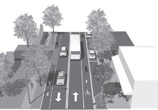
It is important that 22nd Street South and 5th Avenue South contribute not only to vehicular access, but to the physical, social and economic fabric of the area. As the two most regionally significant streets, 22nd Street South and 5th Avenue North connect across and through the entire study area, including at gateway entrance intersections. Yet, the streets are generally oversized for the amount of vehicular traffic and generally configured for an industrial area. Today, while the area still includes some active industrial uses and land, there is a need to serve a more diverse array of businesses and land uses, as well as the people that work in and patronize those uses.
Clearly, an emergent Main Street and arts/culture community requires more complete facilities for all modes of travel, opportunistic on-street parking and an appearance that more appropriately reflects the energy and personality of the businesses. Fortunately, the streets do not carry high volumes of traffic and there are opportunities to re-allocate some of the asphalt vehicular space to support other users, as well as onstreet parking, trees and other amenities.
Both streets should be “complete streets”. These are streets for everyone. They are design to serve a broad range of users—both young and old, on foot or bicycle, in a car or in a bus—rather than being designed primarily for cars and trucks.
22nd Street South can include a connected solution to bicycle access and streetscape materials—especially sidewalk pavements, crosswalks, trees and lighting— to unify the entire corridor from 1st Street South to 18th Street South. This treatment can also include specific “character areas” such as the 22nd/5th intersection, the I-275 arts and light underpass, and the Main Street. Finally, special buildings, such as the Morean Center for Clay and the Manhattan Casino and Royal Theater, can be featured.
Transform 5th Avenue South to a complete street
The complete street philosophy holds that streets should be designed to serve a broad range of users— both young and old, on foot or on bicycle, in a car or in a bus—rather than being designed primarily for cars and trucks. 5th Avenue South can be reorganized to include dedicated, marked bike lanes, on-street parking and treated with more unified solutions sidewalk, lighting and street tree continuity. Finally, the intersections and key locations can incorporate artistic expression, such as street-print, signage, and environmental art to add personality to the corridor as it traverses the WADA.
This framework is a guideline to provide a comprehensive understanding of the proposed improvements and opportunities for the segment of 22nd Street South from 1st Avenue N to 18th Street S and 5th Avenue N from 28th Street S to 20th Street S.
The overall framework proposes to transform both streets as complete streets, designed to enable safe access for all users, including pedestrians, bicycles, motorist and transit riders of all ages and abilities. Some of the proposed improvements are new sidewalks, street crossings, intersections, bicycle lanes and parking.
22nd STREET S: This is one of the City’s North-South Corridors west of I-275. The section of the corridor within the Study Area is 1.8 miles and starts at 1st Avenue N to 18th Avenue S. This section of the corridor will be a two-lane road with new or improved bicycle facilities, on-street parking, streetscape and intersections. A new transit line has been proposed on this section of the corridor. New bus stop locations will work on the future as trolley stops for the monthly Art Walk Event. New and existing destination along the corridor will be featured including: the Morean Center for Clay, The Manhattan Casino, Deuces Live Main Street segment, former Royal Theatre, St. Petersburg College and two new proposed parks. Because of the distinct character of the street and adjacent buildings along this section of 22nd Street S, the corridor has been divided into six segments (A to F). Each segment will have different configurations and treatments.
22nd STREET S - MAIN STREET CORE: This segment of 22nd Street S will be designed as a brick feature street for the Deuces Live Main Street. This segment will be designed to easily transform into a pedestrian only street for special events, such as festivals, markets and music events.
5th AVENUE S: The new proposed street configuration for this 0.3 mile section from 28th Street S to 20th Street S is a 2 lane-road with bicycle lanes and parking on the south side of the street. The new design on each segment (A and B) will feature new streetscape elements, intersections and pedestrian crosswalks.
FEATURE INTERSECTIONS: These are key intersections and will be designed as gateways for the Warehouse Arts Districts and Deuces Live. Five feature intersections are proposed:
1. @ 5th Avenue S: This intersection has been identified a one of the main feature intersections for both areas.
2. @ Fairfield Avenue S: This is a new proposed intersection featuring the Manhattan Casino and becoming the new gateway for the Deuces Live Main Street.
3. @ 9th Avenue S: This intersection will be the gateway of the Deuces Live Main Street Core Segment.
4. @ 11th Avenue S: This intersection will be the gateway of the Deuces Live Main Street Core Segment.
5. @15th Avenue S: This intersection will be the gateway of the Deuces Live Main Street.
SIGNALIZED INTERSECTIONS: Re-design these intersections to accommodate bicycle and pedestrian movements, and gateways elements.
ENHANCED CROSSWALKS: These are new proposed enhanced as safe pedestrian crossing for pedestrian and cycles. New enhanced crosswalks should be added in each on of them.
BICYCLE LANES: These are on street bicycle lanes.
SHARED BICYCLE LANES: Motorist and cycles will be sharing the lane on theses segments of 22nd Street S. A shared-lane marking will be painted on the road.
NOTE: These recommendations are conceptual and will require refinement and additional due diligence upon implementation.
MAIN STREET CORE
This segment of the 22nd Street S Corridor is within the Deuces Live Main Street Area and is designed to reflect the character, history and future needs of the businesses and residents. This segment can be divided in three sections, Deuces Live Gateway [D: from Fairfield Ave S to 9th Ave S], Main Street Core [E: from 9th Ave S to 11th Ave S] and South Main [F: from 11th Ave S to 15th Ave S]. Each section will have a different street design approach. Some of the key improvements proposed for the segment are:
1. Re-align Fairfield Avenue S at the Manhattan Casino, and create an intersection with a special treatments to work as the new Deuces Live Main Street Gateway.
2. Re-design Main Street Section as a feature street for the Deuces Live Area.
3. Enhance existing intersections by raising the payment, adding adequate pedestrian crossings and gateway features.
Some of the existing challenges are highlighted in the pictures below:


Two Lane Road with Bike Lanes, and OnStreet Parking on the West Side 9TH AVENUE S TO 11TH AVENUE S PROPOSED CONDITION

Two Lane Road with Shared Lanes, and On-Street Parking on the West Side

NOTE: These recommendations are conceptual and will require refinement and additional due diligence upon implementation.
as feature intersections for the Deuces Live Main Street area. They will serve as gateways and promote safe pedestrian and bicycle crossings Each intersection will have different treatments, designs and functions.
2. Fairfield Ave S: This new proposed intersection will become the new entrance/gateway for the Deuces Live Main Street
the Deuces Live Main Street Corridor. Proposed improvements are: new crosswalk markings and decorative/art paint graphics in the interior space of the intersection.
ENHANCED CROSSWALKS: These are new proposed enhanced as safe pedestrian crossing for pedestrian and cycles. New enhanced crosswalks should be


[From Fairfield Ave S to 15th Ave S - Segment D,E,F]
The landscape palette selected for 22nd Street South and Deuces Live Main Street from Fairfield Avenue to 15th Avenue S is a combination of native and ornamental plants. We encourage the use of low impact development (LID) such as stormwater planters or street bulb-outs. A traditional materials and aesthetic streetscape furniture was selected.
NOTE: These aesthetic palette applies to the new streetscape improvements.


[Segment D,E,F - Fairfield Avenue S to 15th Avenue S]
NOTE: These


TYPICAL EXISTING CONDITION
Two Lane with On-Street Parking on the East Side of the Road
[9th Avenue S to 11th Avenue S] PROPOSED CONDITION
Two Lane with On-Street Parking on the West Side of the Road and Shared Bicycle Lanes
Streetscape
[9th Avenue S to 11th Avenue S] PROPOSED CONDITION
Two Lane with On-Street Parking on the West Side of the Road and Shared Bicycle Lanes
Streetscape Improvements:


SEGMENTS A,B & C [From 1st Avenue N to Fairfield Avenue S]
This segment of the 22nd Street S Corridor is designed to provide an adequate bicycle facility, sidewalks, shade and street trees, pedestrian lighting, and uniform aesthetic appearance (see page 62). To be able to accommodate the necessary improvements a few actions need to happen:
1. Remove the center turn lane from 1st Avenue N to 1st Avenue S to accommodate a bicycle facility
2. Require an easement through redevelopment to accommodate on-street parking, sidewalks and street trees.
3. Re-design and improve all signalized intersections and create new 3-and 4-way intersections by adding new crosswalks marking on 2nd Avenue S, 3rd Avenue S and 4th Avenue S.
4. Re-align Fairfield Avenue S at the Manhattan Casino, and create an intersection with a special treatments as the new Deuces Live Main Street Gateway.

Bicycle Lanes Diagonal Trail Crossing

No Street Trees or Pedestrian Lights

The existing condition on this segment is a 2 lane road with a center turn lane. The existing traffic counts don’t justify a dedicated left turn lane, therefore, we are proposing to add protected bicycle lanes, wider sidewalks, street trees and pedestrian lights.

The vision for this segment is to provide wide sidewalks and on-street parking on both side of the street. An easement will be required to achieve this.

The vision for this segment is to provide wide sidewalks and provide on-street parking on both side of the street. An easement will be required to achieve this.
NOTE: These recommendations are conceptual and will require refinement and additional due diligence upon implementation.
& ACTIONS
FEATURE INTERSECTIONS: These are key intersections and will be designed as gateways for the Warehouse Arts Districts and Deuces Live. Two feature intersections are proposed:
1. 22nd Street S and 5th Avenue S: This intersection will be design to addressed all bicycle movements coming from the Trail, 22nd Street S and 5th Avenue S. This intersection has been identified a one of the main feature intersections for both areas.
2. 22nd Street S and Fairfield Avenue S: This is a new proposed intersection featuring the Manhattan Casino and becoming the new gateway for the Deuces Live Main Street for people traveling south on 22nd Street.
SIGNALIZED INTERSECTIONS: Re-design these intersections to accommodate bicycle and pedestrian movements.
ENHANCED CROSSWALKS: These are new proposed enhanced as safe pedestrian crossing for pedestrian and cycles. New enhanced crosswalks should be added in each on of them.
BICYCLE LANES: Widen existing bicycle lanes and add protected bike lanes from 1st Avenue N to 1st Avenue S

[From 1st Avenue N to Fairfield Avenue S and from 28th Street S to 20th Street S]
The landscape palette selected for the 22nd Street Corridor S (from 1st Avenue N to Fairfield Avenue S) and 5th Avenue S is a combination of native and ornamental plants. We encourage the use of low impact development (LID). By implementing LID principles and practices, water can be managed in a way that reduces the impact of built areas and promotes the natural movement of water within an ecosystem or watershed. Contemporary street furniture design and materials, such as concrete, metal, and iron were selected.

CONTEMPORARY STREET LIGHTS


We encourage the use of paint to feature key intersections along the corridor. Key intersections are: Central Avenue, 5th Avenue S, and Fairfield Avenue. When sidewalk space is limited, parklets can be use an extension of the sidewalk to allow outdoor seating, when there is on-street parking available. Business signage for the corridor should be designed in a unique way to highlighted the artistic character of the area.
NOTE: These aesthetic palette applies to the new streetscape improvements.


[ Segments A,B & C - From 1st Avenue N to 7th Avenue S]


1ST AVENUE N TO 1ST AVENUE S PROPOSED CONDITION
Two Lane Road with Protected Bike Lanes
•

Two Lane Road with On-Street Parking on Both Sides and Bike Lanes Streetscape Improvements:
Streetscape Improvements:
• Bike Lanes
• On-Street Parking
• Stormwater Planters/Bulb-Outs
• Pedestrian and Roadway Lights
Two Lane Road with On-Street Parking on West Side and Bike Lanes
• Pedestrian and Roadway
• Bike Racks • Street Trees 5TH AVENUE S 7TH AVENUE S PROPOSED CONDITION
5th Avenue South from 28th Street S to 20th Street S has been designed as a complete street. The vision for this segment is to convert the street from a 4-lane road to a 2-lane road to accommodate bicycle lanes and on-street parking. All the intersections should be re-designed to accommodate safer bicycle and pedestrian crossings. Other proposed improvements include: mid-block crossing, wider sidewalks, street trees, pedestrian lighting and bicycle racks. Wider sidewalks are needed on both sides of the street, but because of the limited right-of-way, an easement is needed provide adequate planting area and sidewalk. Key improvements proposed for 5th Avenue S are:
1. Require an easement through redevelopment to accommodate on-street parking, sidewalks and street trees.
2. Re-design and improve all signalized intersections and create new 4-way and 2-way stops intersections by adding new crosswalks marking on all streets.
Some of the existing challenges are highlighted in the pictures below:


The vision for this segment of 5th Avenue S is to transform the street from a 4-lane road with no on-street parking and bicycle lanes into a 2-lane road with bicycle lanes and on-street parking on the south side of the road.

NOTE: These recommendations are conceptual and will require refinement and additional due diligence upon implementation.
SIGNALIZED INTERSECTIONS: Re-design these intersections to accommodate bicycle and pedestrian movements. ENHANCED CROSSWALKS: These are new proposed crosswalks on 20th Street S and 25th Street S that will serve as safe pedestrian crossings for pedestrian and cycles. New crosswalks should be added to each of them.
2-WAY STOP INTERSECTIONS: These intersection treatments include: 27th Street S, 26th Street S, 24th Street S and 23rd Street S, that will serve as safe pedestrian crossing for pedestrian and bicyclists. New crosswalks and bicycle box marking should be added to each of them.
BICYCLE LANES: New bicycle infrastructure that will connect to the existing bike lanes on 22nd Street S and 20th Street S, and the proposed bike lanes on 25th Street S and 28th Street S.


Two Lane Road,with Bicycle Lanes, and OnStreet Parking on South Side of the Street

Two Lane Road,with Bicycle Lanes, and OnStreet Parking on Both Side of the Street NOTE:

The Pinellas Trail is a signature public open space for the Study Area, but also for the greater St. Petersburg region. As such, the public and private properties within with WADA area should take advantage of the trail address as an opportunity to invite trail users to stop and experience places within the District. For those merely “passing through” on a regional ride, a noticeable appearance will invite riders to come back. For casual riders or those ready for a break, the areas near the 22nd/5th intersection can serve as trail-head, node of activity, destination, and opportunity to visit.
This will require improvements not only to the trail, but the integration of adjacent public open space (for festivals and small events) and private patio space
Design the Trail as the new District \ destination
Special pavement, lighting, trees and trail-head features across the geography of the WADA, with special treatment at the 22nd/5th intersection, including linkage to the planned 22nd and 5th bicycle facilities.
Encourage access to the Trail from buildings
Retrofit front doors, roll up doors, windows, gateways into parking lots, and flexible use patio spaces that can be accessed from the trail.
Orient the buildings toward the Trail
Where possible, provide front door or side door (secondary access) from the trail. Alternatively, provide pedestrian paths and bike racks easily linking trail users into the property.
Improve the Trail crossings
Modifications at complex 45-degree intersections, taking advantage of the unique geometries to not only improve bike, pedestrian and vehicle safety, but to also brand the district and create uniquely configured outdoor space at the intersection corners.
Design a wayfinding system for the Trail
Develop unique markers, branded graphics, and wayfinding queues to inform the riders about the District points of interest. The systems should be consistent with the City’s wayfinding and Complete Streets Neighborhoods Greenways programs.
where businesses can be featured with active areas easily accessible from the Trail. The buildings along the trail can incrementally adapt to provide a “front door” relationship on the Trail as much as possible. Historically, the industrial buildings backed up to the rail Line. In the future, as buildings are adaptively repurposed, roll up doors and entrance opportunities will make the Trail a friendly sociable place, with nodes of activity at key intersections and business locations. Where building retrofit is not practical, windows, mural art, specialty lighting, and other treatments can make large industrial buildings more animated, interesting, and humanized. The Trail can and should be a significant economic and social activity engine for the District.


We encourage all existing and future buildings located along the Trail to provide access to the trail.
All existing Trail intersections should be improved to provide safer bicycle and pedestrian crossings.
Because of the way the Trail bisects the street grid of the area, unique underutilized triangle pieces of land are created. These pieces of land are great places to create open spaces for the local businesses and visitors.

TRAIL CROSSINGS: These are intersections for cars, pedestrians, and bicycles. All intersections need to be improved. Proposed improvements are:
• 31st Street S: Enhance crosswalk, add new wayfinding sign and art element.
• 28th Street S: Re-design intersection to accommodate bicycle movement from 28th Street S and the Trail. Add new patterned crosswalk, wayfinding sign, and art.
• 24th Street S Re-design of intersection. Add new crosswalk crossing, wayfinding sign, and art.
TRAIL NODES: These are new bicycle and pedestrian connections and access points to the trail. They provide opportunities for resting areas, location of wayfinding signs, and art.
BUILDING ACCESS TO THE TRAIL: We encourage all existing and future buildings located along the trail to provide access to the trail.

TRAIL CORNERS: These are private/public open spaces on pieces of land on which it is difficult to place a structure due to their shape. These can be great trail amenities and resting areas for visitors.
ART & LANDSCAPE ON WALLS/FENCES: We encourage property owners to add murals, art, and vegetation along blank walls or fences located along the trail.
ART PIECES: We encourage the use of vertical art along the trail. The art could be placed in the trail right-of-way or on private property


OPPORTUNITIES & ACTIONS
TRAIL CROSSINGS: These are intersections for cars, pedestrians, and bicycles. All intersections need to be improved. Proposed improvements are:
• 24th Street S: Re-design of intersection. Enhanced crosswalk, wayfinding sign, and art.
• 22nd Street S: Re-Design intersection to accommodate bicycle movement from 22nd Street S and the trail. The center of the intersection can be painted with a special pattern motif.
• 24th Street S: Enhance crosswalk, add new wayfinding sign and art element.
TRAIL NODES: These are new bicycle and pedestrian connections and access to the trail. They provide opportunities for resting areas, location of wayfinding signs, and art.
BUILDING ACCESS TO THE TRAIL: We encourage all existing and future buildings located along the trail to provide access to the trail.

TRAIL CORNERS: These are private/public open spaces on pieces of land on which it is difficult to place a structure due to their shape. These can be great trail amenities and resting areas for visitors.
ART & LANDSCAPE ON WALLS/FENCES: We encourage property owners to add murals, art, and vegetation along blank walls or fences located along the trail.
ART PIECES: We encourage the use of vertical art pieces along the trail. The art could be placed in the Trail right-of-way or on private property


The landscape palette selected for the Pinellas Trail is a combination of native and ornamental plants. We encourage the use of low impact development (LID), as bioswales along the trail. These bioswales would help mediate the water run-off on a natural way. Contemporary street furniture design and materials, such as concrete, metal, and iron were selected. We encourage the use of paint and art elements to animate blank facades or segments of the trail. An example of a wayfinding system is also shown.


NOTE: These aesthetic palette applies to the new streetscape improvements.


Wichita’s wayfinding sign package will cultivate community pride amongst its residents and promote a positive first impression to visitors. Through a public engagement process and a series of stakeholder work sessions a final design was developed that is a reflection of Wichita’s community values. The package acknowledges the existing Greater Wichita Path signage while being more cost effective to implement due to size and materials. The on-street package follows MUTCD guidance with slight touches of City branding while the off-road options bridge the creative gap between the existing Path signs and the new on-street selection. Clarity, visibility, and cost were considered when developing and finalizing the sign family. This suite of options are flexible enough to carry Wichita into the future of an expanded network of bicycle facilities and pedestrian accommodations and creative enough to nod at the brand of the City and historic qualities of the community.
The family is both durable and flexible, it uses materials that resist the natural elements, and deter vandalism. In addition, this design considers modular components that may be simply fabricated and maintained by City facilities staff.
Example Design of the Wichita Bicycle Wayfinding System


Within the WADA and the Deuces, there is a need and opportunity for outdoor events, festivals, and other community activities—if the spaces were available to support them. The need for a formalized, ceremonial space for larger groups can be met with dedicated park spaces as well as informal “pop-up” spaces that can be in the right-of-way (feature streetscape), on underutilized land, in parking lots, and even in temporary “parklets” within on-street parking spaces.
The idea is to provide many opportunities for a wide range of community events and social activities to be accommodated, and for barriers to cultural expression and community gathering to be reduced. Events and exhibits can be fun, temporary and experimental. The
The master plan identifies two feature public parks/ urban square opportunities: 9th/22nd South in the Deuces Live Main Street, and 5th/22nd South in the WADA adjacent to the Pinellas Trail. Each site can be designed artfully, but also as flexible open space that can accommodate a variety of community activities, as well as local relaxation, and shaded respite from the urban environment. Although the parks are physically apart from each other, they can both have similar elements and materials.
Create opportunities for parklets & pop-up parks
Parklets are temporary outdoor patio or seating areas within the on-street parking areas of retail street environments. This expands outdoor retailing and dining space, while maintaining clear passage along the sidewalks, particularly in constrained rights-of-way. This technique could be used on 22nd South in the Deuces and in certain locations in the WADA. Other “pop-up” parks could occur on underutilized property, particularly publically owned sites, which can be treated with minimal improvements to edges and provisions for lighting.
Streets can be designed to accommodate festivals and events within the street environment, and two such opportunities are identified here. First, in the Deuces, the two blocks of 22nd South from 9th to 11th could be a setting for a specially enhanced streetscape.
informal festival and food truck events held in the parking lot adjacent to Three Daughters Brewing is a perfect example. There are more opportunities for these types of events on both private property (as appropriately hosted by local businesses) and in the public realm. The most active and dynamic Districts have a free flow of activity between private patio spaces and adjacent public streets, trails, or parks.
Second, in the WADA, the introduction of a finished street in the 23rd South right-of-way from 5th to Fairfield Avenue (across the Pinellas Trail). These streets can be designed as flexible settings for events, including possibly as “flush condition/shared space” streets with no vertical curb to create tripping obstacles during heavy pedestrian use.
There


There are many program opportunities that can be created on these new open spaces. Here are a few program activities and design ideas:


The landscape palette selected for the park is a combination of native and ornamental plants. We encourage the use of low impact development (LID), such as bioswales along the trail. These bioswales would help mediate the water run-off on a natural way. Contemporary street furniture design were selected, and a combination of industrial, rustic, and contemporary materials—such as wood, iron, concrete, metal, gray, and beige paver were selected.
LANDSCAPE & HARDSCAPE


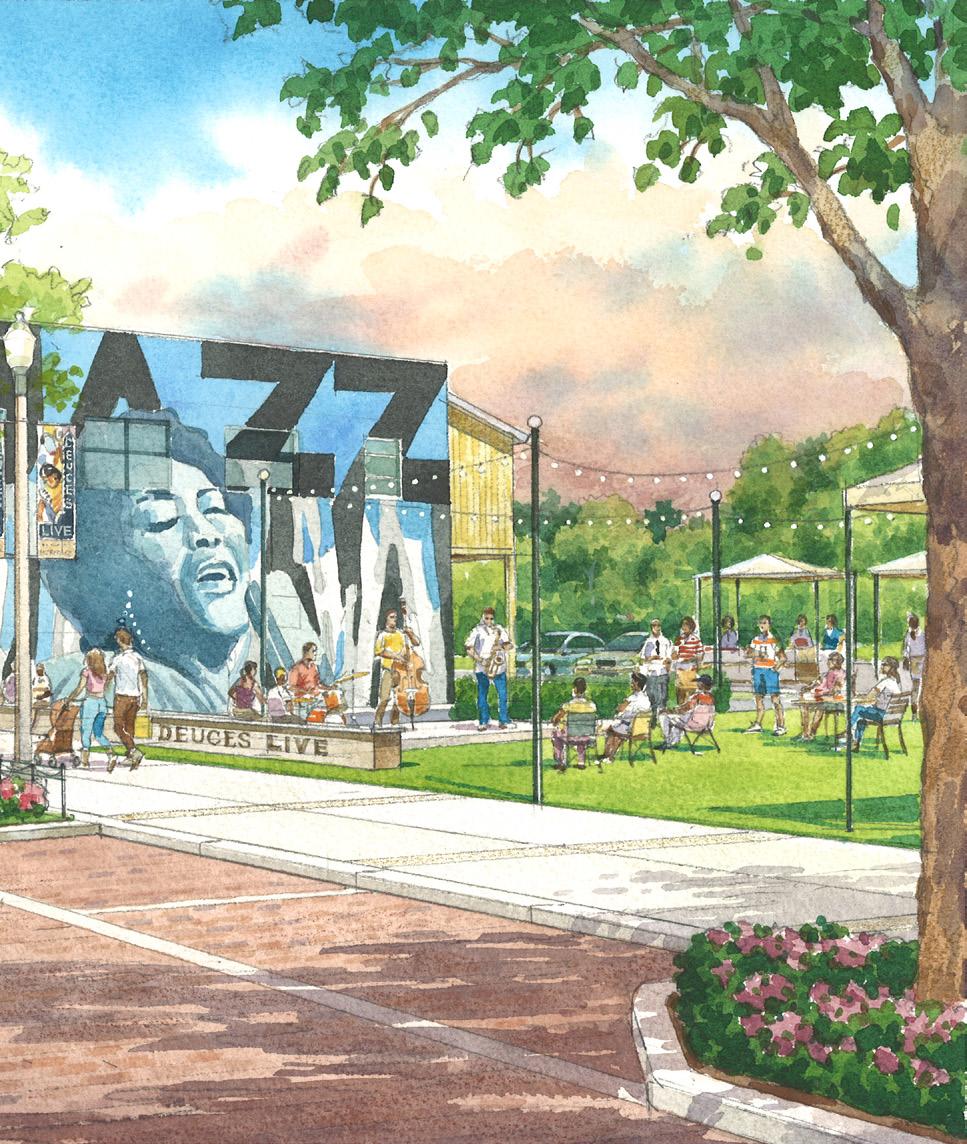
The Deuces Park is located on a 0.40-acre site owned by City of St. Petersburg. This park would be a feature piece for the Deuces Live Main Street, and would provide a gateway to the area. The park offers a multi-purpose structure for the community to host concerts, exercise classes, and markets among others. An open lawn, bike-share station, seating area, signature art piece, and location for food trucks and tents are potential feature. This park would work as a transformational catalyst to help boost the area.
A Build a new district park on the City owned parcel at the corner of 22nd Street S and 9th Avenue S
Purchase the vacant parcel to the north to accommodate parking for the new park
Reconstruct the alley to access the parking and to allow food trucks and services vehicles to park
Improve and re-design 22nd Street to accommodate on-street parking and bicycle lanes
Raise and improve the intersection of 22nd Street S and 9th Avenue S
Re-construct the Deuces Live Main Street Core as a shared brick street
There are many opportunities to create small pop-up or temporary pocket parks along the Deuces Live Corridor. While the area is waiting to be redeveloped, vacant parcels are the perfect incubators for events and activities.


The District Park is located on a 1.40-acre site owned by the City of St. Petersburg next to the Morean Center for Clay at the intersection of 22nd Street S and 5th Avenue S [22/5].
This park will be a destination for the District and will give residents, businesses, and visitors the opportunity to have a public green space to host events, such, as markets, concerts, and classes, among others. A feature element of the park is its location next to Pinellas Trail and the Morean Center for Clay. The designs purpose is to incorporate the Center and the trail as part of the park. The trail space is designed to be a shared space for pedestrians and cycles, as well as a new trail-head for the trail. The park offers a series of elements, including a multi-purpose structure, open lawn, bike-share station, seating area, signature sculpture (former dome sign), and a location for food trucks and tents.
Build a new district park on the City owned parcel at the corner of 22nd Street S and 5th Avenue S
Create a shared space along the trail for cyclists and pedestrian
Integrate the open space in front of the Morean Center for Clay with the new proposed park
Improve and re-design the 22nd Street S and 5th Avenue S intersection to provide safer crossing for pedestrians and cycles
Create open public/private spaces along the trail.
These are new private/public open spaces located along Pinellas Trail. These corners have the potential to become great outdoor spaces for existing and future development. We encourage buildings to open up to the trail and create these new spaces. When 23rd Street S becomes a street or paseo for pedestrians and cycles, an unique opportunity will occur at the intersections of 23rd and Pinellas Trail to generate these proposed spaces. See highlighted yellow area below.
A Reclaim 23rd Street S as a shared space for pedestrians, bicycles, and special events
Create a trailhead/stop at the intersection of the trail and the street
Create new private/public spaces through redevelopment that faces the trail and provide opportunities to have outdoor seating, art pieces, access to buildings from and to the trail, and resting areas for bicycles

23RD STREET S


The most interesting and successful places are often defined by their authenticity. Open expressions of art, culture, industry, makers, music, and food will allow the Deuces Live and WADA to differentiate—creating an attractive sense of place that is distinct from any other place. Benches, signage, pavements, furnishings, building facades, and gateways all provide the opportunity to bring to the exterior urban environment the energy that is inside the buildings, or within the “heart” of the people who make up the community. New business investment and visitor activity is affected by the energy expressed in the physical environment, and there are many opportunities to do so in South St. Petersburg.
Use special graphic motife on key intersections
There are several forms of high quality street print materials that can be used (even on Florida Department of Transportation roads) to mark the streets and crossings in unexpected and creative ways. The basic material is paint, but the higher quality thermal products can last the lifespan of the asphalt, up to 15 years.
Keep using the murals as a trademark feature of the area
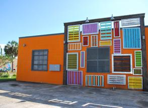
The local WADA and Deuces mural programs have been highly successful and should be continued and expanded.
the use of art elements
Art in the landscape can occur both through special “object art”, as well as “integrated art”, which allows conventional items such as benches, transit shelters, and other facilities to be re-interpreted as customized art opportunities.
Allow the use of business pedestrian signs
Below the scale of the planned city-wide sign system, the local business associations could self-implement localized signage to specific businesses participating in events such as Art Walk. These signs could be on local streets and could be designed outside the constraints of the Manual on Uniform Traffic Control Devices or other conventional traffic control requirements.
Transform the Dome signs into art pieces
The aged Dome Industrial Park concrete monument signs can be re-interpreted as public art, using the structurally sound concrete core as a structure base. Modifications could include paint and textural changes to create color, added materials elements to clad the concrete, using the concrete monument as a structural core, or a completely freestanding piece of exterior sculpture. We recommend that these concrete monuments be re-purposed as public art through a call to artists. It is not considered critical that the new art pieces even use any lettering to identify the area. Their very presence as large outdoor art elements make it clear to the visitor that they are entering the Arts and Cultural Districts to which the regional city sign system will also provide direction.
DOME INDUSTRIAL SIGNS:
There are two different types of dome signs in the District: five eight-foot signs, located at the intersections of 5th Avenue S and 22nd Street S; and one 20-foot sign, located at the intersection of 22nd Street S and 5th Avenue S. We propose to retrofit the small signs into art elements (see page 105) and transform the large sign into a feature sculpture through an artist proposal process.
PAINTED INTERSECTIONS
These are key intersections that should be treated as gateways for the WADA and Deuces Live Corridor. Paint the interior/center space of the intersection with a graphic pattern and motif.
ART AND MURALS ON THE TRAIL
We encourage businesses to paint their blank walls with murals and add art elements.
These are some actions and design ideas of how keep embracing the use of color, form, materials, and art in the Study Area.
DESIGN A DISTINCT PATTERN FOR EACH AREA THAT CAN BE USE ON INTERSECTIONS AND TO DEFINE POP-UP PLACES

CREATE UNIQUE MURALS FOR THE AREA AND BUSINESS


INCORPORATE ART ELEMENTS ON THE TRAIL, PARKS, AND BUSINESS


ALLOW THE USE OF PEDESTRIAN BUSINESS SIGNS TRANSFORM AND RETROFIT DOME SIGNS INTO ART ELEMENTS & SCULPTURES
1
Remove all the elements attached to the sign


Cover a portion of the existing sign with a light box, perforated metal piece, or both


Conduct a call for artists to paint the concrete portion


Transform the large sign located at the corner of 22nd Street S and 5th Avenue S into a feature sculpture by covering the sign completely and using the concrete base as support


The City of St. Petersburg has taken a proactive and engaged approach to new development in the study area. This includes RFPs for both private property and building re-use, negotiation to insure quality urban design and support for Main Street, WADA and other community organizations. Institutions, non-profits and private business entities have collaborated to achieve meaningful outcomes, including the initiative to develop this action plan for infrastructure improvements! However, there is more work to be done—through collaboration of all the players. Each increment of development should contribute to a more vibrant, livable, and economically successful area—serving both current and long-term needs. Partnerships between public, private and institutional entities will be more important over time.
& ACTIONS
Connect destinations and create new distinct character areas and addresses
The study area is large and contains numerous important centers of activity, history, and daily needs, each within character areas that are distinct. It is important for the overall area to celebrate those special places and build smaller, understandable, successful, and navigable places around them, so that over time, the entire region is a network of connected, but distinct places. By responding to a specific need or opportunity in a specific location, the entire District increases its potential for shared success. There is no “one size fits all” solution for WADA/Deuces. Success will be achieved step by step, not in a single sweeping investment or uniform solution.
Develop an adequate parcel and block infrastructure to allow future redevelopment
To be able to position both areas for future growth, basic block infrastructure and organization needs to happen, related to access and connectivity, building placement, parking, and stormwater. The WADA blocks are large and future redevelopment should place their main facade on the primary street, trail, or open space, and provide a percentage of transparency (e.g., windows, opening). Access for parking should happen from the rear of the property or alley. The Deuces Main Street is characterized by very small parcels and shallow lot depths where the challenge will be to create areas of shared parking and cross access to allow for efficient lot development in order to “fill in” the missing pieces of a unified Main Street experience.
Create a building facades and site improvements programs
Each building has some responsibility to be “contributing” to a humanized, attractive, and (where possible) active street scene. However, older buildings may require retrofit that is difficult for the private property owner to implement without some assistance. Fresh paint, awnings, attractive signage, murals and window, and door treatments are all things that can enhance the exterior appearance of an older building with dated materials, worn finishes, or shuttered/ dark windows. For some buildings, such as some of the warehouses, or the former Housing Authority Administrative Office (now St. Petersburg College), there are architectural opportunities to open new doors to the street.
Identify and acquire potential sites for redevelopment, open space, and/or housing
There are some locations where the City owns property, which, if combined with adjacent property, could result in a more organized development site. These could be used, open space to support a private site, or another form of land swap to make a site developable. In particular, there are vacant or underutilized properties that could be assembled by the City or another agent to position for updated/new housing or other community uses particularly in the southern blocks of 22nd Street S.
Create partnerships with local institutions
The City has already participated in many partnerships across the study area. However, there are still more opportunities and needs for collaboration. One example uncovered during the project was the (potential) linkage between the Royal Theater (which currently houses the Boys & Girls Club and is underused as a community theater) and the former Housing Authority Gymnasium (now owned by St. Petersburg College), which could provide additional recreational space for the children.
Develop a task force for long-term project implementation
As the Action Plan is implemented, it will be critical to maintain continuity in ideas and leadership. Today, the City staff and the Deuces Main Street and WADA Boards are well engaged in the initiatives herein. The ongoing participation of existing players as well as those with new energy is a critical component to executing on the plan over many years. This is a long-term undertaking. The plan is a guidepost to many initiatives that can happen over the next 10+ years, and can also be adjusted as new opportunities arise if there is continuity in leadership and adherence to the Guiding Ideas (if not the details) of this Action Plan.
CREATE A BUILDING FAÇADES AND SITE IMPROVEMENTS PROGRAMS


CREATE PARTNERSHIPS WITH LOCAL INSTITUTIONS


DEVELOP AN ADEQUATE PARCEL AND BLOCK INFRASTRUCTURE TO ALLOW FUTURE REDEVELOPMENT
ALLEY SYSTEM: Preserved and enhance all the alleys systems.
PARKING & STORMWATER: Create a shared parking and stormwater infrastructure to maximize the development area and locate them next to the alley and behind the building when possible.
BUILDING AREA : All buildings should be located fronting a primary street.
BUILDING FRONTAGE: Main building frontage should face a primary street.


THIS ACTION PLAN IDENTIFIES THREE LEVELS OF IMPROVEMENT: BASIC IMPROVEMENT PROJECTS (SIDEWALKS, STREET TREES, LIGHTING, ETC.), PROGRESSIVE PROJECTS (STREETSCAPES, ROAD DIETS, BIKE LANES, ETC.) AND TRANSFORMATIONAL PROJECTS (SIGNATURE PARKS AND STREETS) THAT ARE RESPONSIVE TO THE OPPORTUNITIES OF INDIVIDUAL PLACES, WHILE WORKING TO CREATE A MORE UNIFIED, CONSISTENT INFRASTRUCTURE FOR THE OVERALL REGION.
THE PROJECTS CAN BE IMPLEMENTED OVER MANY YEARS, PIECE BY PIECE, WITH FOCUS ON ALL THREE LEVELS OF IMPROVEMENT SIMULTANEOUSLY AS PART OF A SUSTAINED INITIATIVE TO ACHIEVE SUCCESS ON LARGE AND SMALL SCALES OVER TIME.
• Develop a transit and bicycle network framework
• Develop a street network framework
• Create streescape design standards
• Improve key streets and intersections
• Reclaim and preserve underdeveloped streets
• Preserved and improve the alleys
• Create design
for
•
• Design the trail as the new District destination
• Encourage access to the trail from buildings
• Orient the buildings toward the trail
• Improve trail crossings
• Design a wayfinding system for the trail
•
• Develop
NOTE: The budget figures provided are opinions of probable cost based on conceptual planning and include 35% contingency mark up and 15% design/engineering soft costs. Actual costs may vary based on market, time of implementation and detail decisions made in final design regarding level of complexity & finish.


Potential Sources of funding initially include City of St. Petersburg, South St. Petersburg CRA as well as partnerships with the many local agencies, institutions and interest groups that are active in the area. The Action Plan also includes many project which would be eligible for other Grant programs focused on recreation, transportation and trails. Appropriate funding sources and partners can be leveraged as the projects are prioritized and developed over time.
