

GUIDA RIFUGI
OSPITALITÀ IN ALTA QUOTA
BERG HÜTTEN, GASTFREUNDSCHAFT IN GROSSER HÖHE
MOUNTAIN HUTS, HOSPITALITY AT HIGH ALTITUDE
UN’APP, INFINITE POSSIBILITÀ
Tutti i percorsi di trekking e in bicicletta, con informazioni e suggerimenti utili per le tue escursioni a portata di smartphone. Con l’app FVG OUTDOOR puoi scoprire un intero territorio attraverso gli occhi e i consigli di chi lo vive. Che tu sia un ciclista esperto o un escursionista alle prime armi, un amante dei villaggi pittoreschi o della natura incontaminata, sulla nostra mappa interattiva troverai tutto quello che cerchi… e anche di più.
ONE APP, ENDLESS POSSIBILITIES
All the trekking and cycling routes, with useful information and suggestions for your excursions within reach of your smartphone. With the FVG OUTDOOR app you can discover an entire territory through the eyes and advice of those who live it. Whether you are an expert cyclist or a novice hiker, a lover of picturesque villages or of unspoilt nature, on
EINE APP, ENDLOSE MÖGLICHKEITEN
Alle Wander- und Fahrradrouten
Ihres Smartphones. Mit der FVG OUTDOOR-App können Sie ein ganzes Gebiet mit den Augen und Ratschlägen derer entdecken, die es leben. Ob Sie nun ein erfahrener Radfahrer oder ein Anfänger beim Wandern sind, ob Sie und mehr


DOWNLOAD
APP FVG OUTDOOR


Esperienze d’alta quota
Se amate immergervi nell’atmosfera tranquilla e negli spazi
incontaminati della montagna, in un paesaggio suggestivo lontano dai ritmi frenetici della vita quotidiana, i rifugi sono i luoghi ideali.
Dalle Dolomiti Friulane, con il loro magnifico
Parco, alle Alpi Carniche, tra profondi valichi e grandiosi massicci, fino alle più selvagge Alpi Giulie, i monti del Friuli Venezia Giulia sono costellati da una fitta serie di strutture in grado di offrire ospitalità e ristoro in quota. Territorio perfetto per gli amanti del trekking, la montagna friulana si lascia scoprire attraverso una rete di sentieri ben segnalati e forniti di numerosi punti di appoggio per straordinarie salite o più semplici escursioni panoramiche. Comodi sentieri, che si snodano attraverso fitti boschi e suggestivi versanti, permettono di raggiungere in un paio d’ore di marcia splendidi rifugi alpini ed escursionistici che offrono una calorosa accoglienza e servizi adeguati.
Anche i rifugi alpini, accessibili esclusivamente a piedi attraverso sentieri più impegnativi, immersi nel silenzio di incredibili paesaggi, offrono riposo in comode camerate e anche la possibilità di conoscere i sapori della tradizione. E per scegliere le escursioni preferite si può trarre spunto dai taccuini di viaggio di grandi alpinisti: le strutture d’alta quota, che aderiscono al progetto “Mi Rifugio in Biblioteca”, diventano vere e proprie biblioteche arricchite da una grande varietà di libri, riviste, cartine topografiche e testi fotografici sulla montagna circostante, dove anche alla musica a volte è riservata, con il programma “Note e Parole in Rifugio”, un’accoglienza speciale.

Höhenerfahrung
Wenn Sie es lieben, in einer ruhigen Atmosphäre und in die unberührte Bergwelt, in eine eindrucksvolle Landschaft, fern von den tosenden Rhythmen des so genannten täglichen Lebens einzutauchen, sind die Berghütten dafür die idealen Orte.
Von den Friauler Dolomiten, mit ihrem faszinierenden Park, zu den Karnischen Alpen, zwischen tiefen Pässen und grandiosen Bergmassiven, bis zu den wilden Julischen Alpen, sind die Berge des Friaul-Julisch Venetien mit einer dichten Reihe an Einrichtungen ausgestattet, die in den Bergen Gastfreundschaft und Erholung bieten können. Ein perfektes Gebiet für die Trekking-Liebhaber. Die Berge des Friauls können über ein dichtes Netz gut gekennzeichneter Wege und von dem Vorhandensein zahlreicher Stützpunkte für außerordentliche Anstiege oder einfacher Panorama-Ausflüge entdeckt werden. Bequeme Wege, die sich durch die dichten Wälder schlängeln und beeindruckende Hängeer lauben in einigen Stunden Fußmarsch traumhafte Berg- und Schutzhütten zu erreichen, die eine warme Gastlichkeit und
angemessene Services bieten. Auch die Berghütten, die inmitten des Stille unglaublicher Landschaften, nur über die schwierigsten Pfade zu Fuß erreichbar sind, bieten nicht nur Erholung in bequemen Schlafsälen, sondern auch die Möglichkeit die traditionellen Genüsse kennenzulernen. Und um die besten Wanderrouten auszuwählen, kann man die Reisenotizen der großen Alpinisten hinzuziehen: Die Einrichtungen in den Bergen, die Teil des projektes “Mi Rifugio in Biblioteca” (Die Bibliothek, mein Refugium) sind, werden zu echten und wahren Bibliotheken, reich an einer Vielzahl von Büchern, Zeitschriften, topographischen Karten und photographischen Texten zur umgebenden Bergwelt, wo auch der Musik manchmal eine besondere Gemütlichkeit vorbehalten ist.

High-Altitude Experiences
If you love being immersed in peaceful environments and unspoilt mountainous areas, in scenic landscapes far away from the hectic pace of everyday life, then mountain huts are the perfect places for you.
An extensive range of facilities that offer high-altitude hospitality and refreshments stretch across the Friulian mountains, such as the Dolomites with their magnificent Park, between the deep valleys and majestic mountain ranges of the Carnic Alps, and the wilder Julian Alps. The perfect area for hiking enthusiasts, the Friulian mountain lets you discover its extraordinary climbs or more simple scenic hikes for yourself with its network of well-marked trails and numerous rest points. Easy-going trails which wind through the dense forests and picturesque slopes, and reach wonderful mountain and hiking huts after just a couple of hours’ walk. These huts offer a warm welcome and adequate amenities. Even the alpine huts which can only be accessed by foot via more challenging trails, are immersed in the silence of the incredible landscapes
and provide rest in comfortable dormitories, in addition to the chance to taste traditional dishes. In order to choose your favourite hiking trails, you can draw inspiration from the travel diaries of some of the great climbers: the high-altitude facilities that belong to the “Mi Rifugio in Biblioteca” (My Mountain Hut Escape in the Library) project, become real libraries. They are enriched with a wide variety of books, magazines, topographic maps and photographic texts on the surrounding mountainous area, where sometimes even music is provided in special venues, thanks to the “Note e Parole in Rifugio” (Notes and Words from Mountain Hut Escapes) programme.
Friuli Venezia Giulia
Dolomiti Friulane Pag. 7
Alpi e Prealpi Carniche Pag. 22
Alpi e Prealpi Giulie Pag. 44
Valli del Natisone Pag. 58

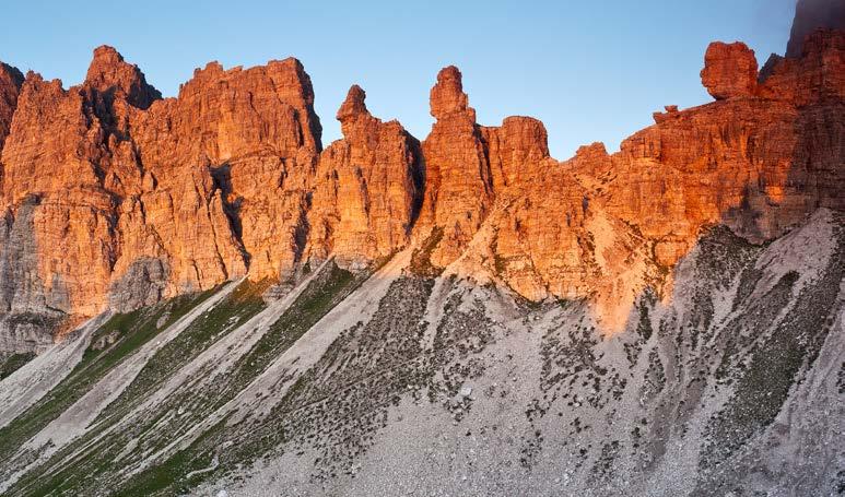
La grandezza delle Dolomiti Friulane
Meta privilegiata di alpinisti ed escursionisti, le Dolomiti Friulane sono riconosciute come la parte più incontaminata dell’intero gruppo dolomitico oggi Patrimonio dell’Umanità UNESCO.
Simbolo incontrastato di queste montagne è il Campanile di Val Montanaia, sfida per i trekker più allenati, mentre sentieri e percorsi sempre curati consentono a tutti di attraversare completamente l’omonimo Parco (www.parcodolomitifriulane.it) scrigno di rocce e praterie adornate da una miriade di orchidee e stelle alpine, dove capita spesso di imbattersi in camosci, marmotte, galli cedroni e cervi o di incrociare, con lo sguardo tra le guglie dolomitiche, il volo maestoso dell’aquila reale. Una capillare ed equilibrata distribuzione dei rifugi permette ai più esperti di compiere itinerari di più giorni.
Anello delle Dolomiti Friulane, suggestivo anello Trekking da 5 o 6 giorni da rifugio a rifugio nel Parco Naturale delle Dolomiti Friulane, con numerose possibilità di varianti con difficoltà e impegno diversi e di salite anche alpinistiche alle vette.
Alta via di Forni (via delle Dolomiti n. 6), da coprire in 5 giorni immersi nella wilderness del Parco Dolomiti Friulane a cospetto delle cime dei gruppi dei Monfalconi, del Cridola e del Clapsavon e facendo tappa nei rifugi o in ex casere che conservano le atmosfere di un tempo.
Die Grossartigkeit Der Friaulischen Dolomiten
Bevorzugtes Ziel von Bergsteigern und Wanderern, werden die Friauler Dolomiten als der unberührteste Teil der gesamten Berggruppe der Dolomiten anerkannt, die heute Teil des UNESCO Weltkulturerbes sind.
Das unangefochtene Symbol dieser Berge ist der Campanile di Val Montanaia, eine Herausforderung für gut trainierte Trekker, während die gepflegten Wanderwege und Routen es allen ermöglichen, den gleichnamigen Park zu durchqueren (www. parcodolomitifriulane.it), ein Schmuckstück aus Felsen und von Tausenden von Orchideen und Edelweiß umgebenen Wiesen, wo es häufig vorkommt, dass man auf Gemsen, Rehe, Murmeltiere, Auerhähne und Hirsche trifft, oder mit dem Blick auf die Felsnadeln der Dolomiten, den majestätischen Flug des Steinadlers kreuzt. Eine engmaschige und gleichmäßige Verteilung der Berghütten ermöglicht den
Fortgeschrittenen das Bewältigen der Touren in mehreren Tagen.
Rundweg der Friauler Dolomiten, ein eindrucksvoller Trekking-Rundweg über 5 oder 6 Tage, von Berghütte, zu Berghütte im Naturpark der Friauler Dolomiten, mit zahlreichen Möglichkeiten mit unterschiedlichen Schwierigkeitsgraden, sowie Bergtouren zu den Gipfeln.
Alta via di Forni (Dolomitenweg Nr. 6), 5 Tage inmitten der Wildniss des Parks der Friauler Dolomiten, im Angesicht der Gipfel der Bergruppen der Monfalconi, des Cridola und des Clapsavon, mit Halt in den Berghütten oder ehemaligen Hütten, die noch heute die Atmosphäre von damals bewahren.
The magnitude of the Friulian Dolomites
A favourite destination for mountaineers and hikers, the Friulian Dolomites are recognised as the most pristine part of the Dolomite mountain range, and are now a UNESCO World Heritage Site.
The unmistakable symbol of these mountains is the Campanile di Val Montanaia, a challenge for the fittest hikers, whilst well-maintained trails and paths mean that anyone can fully cross the homonymous park (www.parcodolomitifriulane.it). A treasure chest of rocks and meadows, adorned by a myriad of orchids and edelweiss, where it is easy to run into chamois, marmots, grouse and deer, or catch a glimpse of the majestic flight of the golden eagle, when looking towards the Dolomite peaks. A widespread and even
distribution of mountain huts, allows the more experienced hikers to undertake multiple-day routes.
Anello delle Dolomiti Friulane, a picturesque 5 or 6 day circular trail from mountain hut - to mountain hut in the Natural Park of the Friulian Dolomites, with many options that have varying degrees of difficulty, commitment and climbs, including peak climbing.
Alta via di Forni (Via delle Dolomiti n. 6) can be covered in 5 days and is immersed in the wilderness of the Friulian Dolomites Park. It runs through the Monfalconi, Cridola and Clapsavon range peaks, and stops at mountain huts or former Caseras that preserve the atmosphere of a time gone by.

Rifugio Vallata
Mobile: +39 349 7053300
e-mail: info@rifugiovallata.it / rifugio@rifugiovallata.it / www.rifugiovallata.it
Località / Lage / Location: Barcis (PN)
Gruppo / Berggruppe / Moutain Range: Valcellina - Lago di Barcis
Mappa / Karte/ Map: Tabacco - Fg 021 Dolomiti Friulane e d’Oltre Piave
Gestione / Betreiber / Management: Salvador Bruna / Riccardo Gasparini
Proprietà / Besitz / Ownership: Fam. Gasparini
Periodi di apertura / Öffnung / Opening
Tutto l’anno / Ganzjährig / All year round
Percorsi in quota / Höhenwege / Mountain Trails
Sentiero del Dint dal Lago di Barcis
Principali ascensioni / Hauptaufstiege / Main Ascents
Escursioni nei sentieri della Riserva Naturale Forra del Cellina www.parcodolomitifriulane.it
Accesso
Dall’autostrada A28 prendere l’uscita per Pordenone e proseguire in direzione Maniago e Montereale Valcellina. Da qui, continuare verso Barcis e svoltare a sinistra prima di entrare in paese, in modo da raggiungere l’altra sponda del lago. Al primo incrocio svoltare a destra e seguire quindi le indicazioni stradali per il Rifugio.
Wegbeschreibung
Von der Autobahn A28 die Ausfahrt nach Pordenone nehmen und in Richtung Maniago weiterfahren und Montereale Valcellina. Von hier aus weiter in Richtung Barcis und vor dem Dorf links abbiegen, um das andere See-Ufer zu erreichen An der ersten Kreuzung nach rechts abbiegen und dann den Hinweisschildern zur Berghütte folgen.
How to get there
Take the Pordenone exit on the A28 motorway and continue towards Maniago and Montereale Valcellina. From here, continue towards Barcis and turn left before entering the village, to reach the other side of the lake. Turn right at the first junction and then follow the road signs for the Mountain Hut.
1.249 m

Rifugio Pordenone
T: +39 0427 87300 / Mobile: +39 335 5224961
e-mail: rifugio.pordenone@yahoo.it / www.rifugiopordenone.it
Località / Lage / Location: Cimolais (PN)

Gruppo / Berggruppe / Moutain Range: Gruppo Spalti di Toro / Monfalconi - Val Meluzzo
Mappa / Karte/ Map: Tabacco - Fg 021 Dolomiti Friulane e d’Oltre Piave
Gestione / Betreiber / Management: Marika Freschi / Ivan da Rios
Proprietà / Besitz / Ownership: CAI - Sezione di Pordenone
Periodi di apertura / Öffnung / Opening
Maggio - Settembre / Mai - September/ May - September
Percorsi in quota / Höhenwege / Mountain Trails
Alta Via n 6, Via Alpina, Sentiero Micheluz, Anello del Campanile, Anello delle Dolomiti Friulane, Anello delle Postegae, Ferrata Cassiopea (EEA)
Principali ascensioni / Hauptaufstiege / Main Ascents
Campanile di Val Montanaia, Monfalconi, Diedro dell’Anticima Meluzzo, Croda Cimoliana, Cima Toro, Cima Emilia
Accesso
Da Cimolais (651 m) si risale la Val Cimoliana con la carrozzabile (attenzione alle condizioni in caso di forti piogge) costeggiando il torrente Cimoliana. Dopo 13 km si raggiunge il Pian Meluzzo; al bivio per la Val Meluzzo, proseguire sulla carrozzabile a sinistra sino a giungere ad una zona di parcheggi da dove parte il sentiero che in pochi minuti (10) porta al rifugio situato tra la Val Montanaia e la Val Meluzzo, alle pendici di Cima Meluzzo. Possibilità di pernottamento sulle casette sugli alberi.
Wegbeschreibung
Von Cimolais (651 m) geht es das Val Cimoliana die Straße hinauf (Vorsicht bei starken Regen), entlang des Wildbachs Cimoliana. Nach 13 km erreicht man Pian Meluzzo. An der Gabelung zum Val Meluzzo der Straße nach links folgen, bis zum Erreichen eines Parkplatzes, von wo aus innerhalb von wenigen Minuten (10) die Berghütte erreicht wird, die sich zwischen dem Val Montanaia und dem Val Meluzzo, an den Hängen der Cima Meluzzo befindet.
How to get there
Head up the Cimoliana Valley from Cimolais (651 m) via the road that runs along the Cimoliana Stream (please beware of the road conditions if it has rained heavily). You will reach the Pian Meluzzo after 13 km; at the junction for Val Meluzzo, continue left on the road until you reach a parking area at the start of the trail. Within minutes (10), this trail will lead you to the mountain hut situated between the Val Montanaia and the Val Meluzzo, at the slopes of the Meluzzo Peak.
MI RIFUGIO IN BIBLIOTECA
Cime di Pino 1 3 956 m
Rifugio
Casera Ditta
T: +39 0427 666253
20 1
Località / Lage / Location: Erto e Casso (PN)
Gruppo / Berggruppe / Moutain Range: Gruppo Col Nudo / Cavallo in Val Mesaz
Mappa / Karte/ Map: Tabacco - Fg 021 Dolomiti Friulane e d’Oltre Piave
Gestione / Betreiber / Management: Adriano Roncali
Proprietà / Besitz / Ownership: Privata
Periodi di apertura / Öffnung / Opening
Tutto l’anno / Ganzjährig / All year round
Percorsi in quota / Höhenwege / Mountain Trails
Giro delle 2 forcelle, Giro delle 4 forcelle, Giro dei Rondoni.
Principali ascensioni / Hauptaufstiege / Main Ascents
Accesso
Da Erto si segue la statale verso Longarone. Dopo il bivio con Casso, prendere a sinistra la strada asfaltata verso Pineda. Poco prima di Pineda prendere a sinistra la forestale (cartelli di segnalazione della Casera - Sentiero CAI 905) che dopo alcuni tratti ripidi, si trasforma in una mulattiera. Attraversato un bosco di faggi e due brevi tratti franosi, si arriva al ponticello sul torrente Mesaz che conduce direttamente alla casera, situata in uno splendido anfiteatro dell’Alta Valle, dominato dalle maestose vette del Monte Toc, della Croda Bianca, del Cimon di Valbona, delle Cime di Pino e del Col Nudo.
Wegbeschreibung
Ab Erto der Bundesstraße in Richtung Longarone folgen. Nach der Gabelung nach Casso geht links eine Straße ab, die zum Ortsteil Pineda durch den führt. Kurz vor Pineda nimmt man links die Forststraße (sichtbare Hinweisschilder der Casera - Weg CAI 905). Nach dem Durchqueren eines Buchenwaldes und zweier kurzer rutschiger Abschnitte erreicht man die kleine Brücke über den Wildbach Mesaz. Von hier aus gelangt man direkt zur Hütte, die sich in dem herrlichen Amphitheater des Alta Valle befindet.
How to get there
Follow the trunk road towards Longarone, from Erto. After the Casso junction, a paved road on the left leads to Pineda, via Monte Toc. Shortly before reaching Pineda, take a left onto the forest road (the Casera is clearly signposted - CAI 905 trail), which after a few steep sections, becomes an easy mule track. Cross a beech forest and after two short landslide-prone stretches, you will reach the Mesaz Stream bridge, which leads directly to the Casera. This structure is situated in a beautiful amphitheatre of the Alta Valle.
1.200 m

Rifugio Casera Mela
Mobile: + 39 333 7857908
e-mail: info@caseramela.it / www.caseramela.it
Località / Lage / Location: Erto e Casso (PN)
Gruppo / Berggruppe / Moutain Range: Dolomiti Friulane / Val Zemola
Mappa / Karte/ Map: Tabacco - Fg 021 Dolomiti Friulane e d’Oltre Piave
Gestione / Betreiber / Management: Davide Corona
Proprietà / Besitz / Ownership: Davide Corona
Periodi di apertura / Öffnung / Opening
Maggio - Ottobre / Mai - Oktober / May - October
Percorsi in quota / Höhenwege / Mountain Trails
Alta Via 6 dei Silenzi Anello della Val Zemola
Principali ascensioni / Hauptaufstiege / Main Ascents
Duranno, Cima Frati e Cima Preti
Accesso
Per chi arriva dal Veneto: dall’Autostrada A27 prendere l’uscita Pian di Vedoia, seguire per Longarone - Erto. Nell’unica rotonda ad Erto prendere per la Val Zemola e proseguire per 3,5 km.
Per chi arriva dal Friuli Venezia
Giulia: dall’Autostrada A28 prendere l’uscita per Pordenone e seguire per Maniago - Montereale Valcellina fino a Erto. Nell’unica rotonda ad Erto prendere per la Val Zemola e proseguire per 3,5 km. Disponibile una dependance da 5 posti letto e bagno privato.
Wegbeschreibung
Anreise aus den Venetien: von der Autobahn A27 die Ausfahrt Pian di Vedoia nehmen und in Richtung Longarone - Erto fahren. Am einzigen Kreisverkehr von Erto in Richtung Val Zemola abbiegen und weitere 3,5 km fahren.
Anreise aus dem Friaul-Julisch
Venetien: von der Autobahn A28 die Ausfahrt nach Pordenone nehmen und weiter nach ManiagoMontereale Valcellina bis nach Erto. Am einzigen Kreisverkehr von Erto in Richtung Val Zemola abbiegen und weitere 3,5 km fahren.
How to get there
For those coming from Veneto: take the Pian di Vedoia exit off the A27 motorway and follow the signs for Longarone - Erto. At Erto’s only roundabout, take the road for Zemola Valley and continue for 3.5 km.
For those arriving from Friuli Venezia Giulia: Take the Pordenone exit on the A28 motorway and follow the signs for Maniago - Montereale Valcellina, until you reach Erto. At Erto’s only roundabout, take the road for Zemola Valley and continue for 3.5 km.

1.758 m
2
Rifugio Cava Buscada
T: +39 0427 666746 / Mobile: +39 328 4625598 / +39 320 0413665
e-mail: info@cavabuscada.com / www.cavabuscada.com
Località / Lage / Location: Erto e Casso (PN)
Gruppo / Berggruppe / Moutain Range: Dolomiti Friulane Val Zemola
Mappa / Karte/ Map: Tabacco - Fg 021 Dolomiti Friulane e d’Oltre Piave
Gestione / Betreiber / Management: Famiglia Corona
Proprietà / Besitz / Ownership: Famiglia Corona Accesso
Periodi di apertura / Öffnung / Opening
Giugno - Settembre. Aprile, maggio, ottobre, novembre solo fine settimana o su prenotazione
Juni - September. April, Mai, Oktober, November nur am Wochenende, bzw. nach Voranmeldung
June - September. April, May, October, November, open on weekends only or by reservation only
Percorsi in quota / Höhenwege / Mountain Trails
Troi dal Sciarbon, Anello della Val Zemola, Sentiero Zandonella, Sentiero CAI 381 (Lastre San Daniele)
Principali ascensioni / Hauptaufstiege / Main Ascents
Cima Palazza, Libri di San Daniele
ll rifugio è raggiungibile a piedi da Erto attraverso il sentiero CAI 381 dal parcheggio “Stei de Mela”. Una variante è rappresentata dal segnalato sentiero del cavatore. Da Casso si può arrivare attraverso il “Troi dal Sciarbon” fino al congiungimento col sentiero CAI 381. In Mountain Bike a Erto si sale verso la Val Zemola in una decina di chilometri. Servizi Escursioni didattiche e possibilità di visite guidate al museo all’aperto della vecchia Cava di marmo. Previa richiesta, per le persone con ridotte capacità motorie è disponibile un servizio navetta a pagamento da Casera Mela.
Wegbeschreibung
Die Berghütte ist zu Fuß von Erto über den Pfad CAI 381 zu erreichen. Das Auto ist auf dem Parkplatz „Stei de Mela“ abzustellen und anschließend zu Fuß weiterzugehen. Eine Variante stellt der Pfad „Sentiero del Cavatore“. Von Casso gelangt man über den „Troi dal Sciarbon“ bis zum Zusammentreffen mit dem Wanderweg CAI 381. Mit dem Mountainbike geht es ab Erto einige Kilometer zum Val Zemola hinauf. Nach vorheriger Anfrage steht Menschen mit eingeschränkter Bewegungsfreiheit ein ShuttleService ab Casera Mela zur Verfügung.
How to get there
The mountain hut can be reached on foot from Erto via the CAI 381 trail. Leave your car at the “Stei de Mela car park and continue on foot. There is also the “sentiero del cavatore” (quarryman’s path) which is clearly marked. From Casso, you can arrive via the “Troi dal Sciarbon”, until it joins the CAI 381 path. From Erto, you can climb up ten kilometres or so to the Zemola Valley on a mountain bike. Services Educational hikes and guided tours to the old marble quarry open-air museum are offered. On request, Casera Mela offers a shuttle service (surcharge) for people with reduced mobility.
Rifugio Maniago

Località / Lage / Location: Erto e Casso (PN)
Gruppo / Berggruppe / Moutain Range: Gruppo Duranno in Val Bozzia
Mappa / Karte/ Map: Tabacco - Fg 021 Dolomiti Friulane e d’Oltre Piave
Gestione / Betreiber / Management: Celestina Picozzi - Proprietà / Besitz / Ownership: CAI Maniago
Periodi di apertura / Öffnung / Opening
Giugno - Settembre. Aprile, maggio, ottobre, novembre solo fine settimana o su prenotazione
Juni - September. April, Mai, Oktober, November an den Wochenende, bzw.nach Voranmeldung
June - September. April, May, October, November open on weekends by reservation only
Percorsi in quota / Höhenwege / Mountain Trails
Anello della Val Zemola, Alta Via n. 6, Sentiero Zandonella
Principali ascensioni / Hauptaufstiege / Main Ascents
Forcella Duranno, Centenere, Zita
Accesso
Da Erto (778 m) si sale per la strada della Val Zemola, aperta al traffico veicolare fino alla Casera di Mela. Poco prima della Casera si dirama una strada forestale, la si segue fino ad un secondo bivio. Si prosegue sulla destra fino a raggiungere il Pian di Mandriz (1203 m) dove la carrareccia finisce ed inizia il sentiero (segnavia CAI 374). Attraversato il torrente si inizia a salire nel bosco, raggiungendo Casera Pezzei in circa 1 ora. Da qui ci vuole un’ora fino al Maniago. Chi pernotta o pranza al rifugio può salire con l’auto fino alla fine della strada e continuare a piedi per 10/15 minuti.
Wegbeschreibung
Ab Erto (778 m) steigt man die Straße des Val Zemola an, die für den Fahrzeugverkehr bis zur Casera di Mela geöffnet ist. Kurz vor der Casera geht eine Forststraße ab, der bis zu einer zweiten Abzweigung zu folgen ist. Es geht weiter nach rechts bis zum Erreichen des Pian di Mandriz (1203 m), wo der Karrenweg endet und der Wanderweg beginnt (Wegmarke CAI 374). Wir überqueren den Bach und steigen in den Wald hinauf, bis wir in etwa 1 Stunde die Casera Pezzei erreichen. Von hier aus erreicht man in einer Stunde das Maniago - Hütte. Wer in der Hütte übernachtet oder zu Mittag isst, kann bis zum Ende der Straße fahren und 10 bis 15 Minuten zu Fuß weitergehen.
How to get there
From Erto (778 m), head up the Zemola Valley road which is open to traffic, until you reach Casera di Mela. Shortly before the Casera, the forest road branches off, follow this up to the second junction. Turn right at the junction and continue straight ahead until you reach the Pian di Mandriz (1203 m), where the track ends and the trail begins (CAI 374 trail mark). After crossing the stream, one begins to climb into the woods, reaching Casera Pezzei in about 1 hour. From here it takes an hour to Rifugio Maniago. Those who stay overnight or have lunch at the hut can drive up to the end of the road and continue on foot for 10 to 15 minutes.
MI RIFUGIO IN BIBLIOTECA
m

Rifugio Pradut
Mobile: +39 345 8289307
e-mail: rifugio.pradut@gmail.com
Località / Lage / Location: Claut (PN)
Gruppo / Berggruppe / Moutain Range: Versante nord del monte Resettum, nelle Dolomiti Friulane
Mappa / Karte/ Map: Tabacco - Fg 021 Dolomiti Friulane e d’Oltre Piave
Gestione / Betreiber / Management: Angelo Grava
Proprietà / Besitz / Ownership: Comune di Claut
Periodi di apertura / Öffnung / Opening
Apertura estiva Giugno Settembre. Apertura invernale festività natalizie
Sommeröffnung: Juni -September. Winteröffnung Weihnachtsferien
Summer Opening: June -September. Winter Opening Christmas holidays
Percorsi in quota / Höhenwege / Mountain Trails
Anello Casavento-Landre Scur-Rifugio Pradut, Ruderi casera Resettum e alberi monumentali; Mountain-Bike Anello Forcella Clautana (1432m), giardino botanico del Pradut. Alta via dei Clautani
Principali ascensioni / Hauptaufstiege / Main Ascents
Cimon del Pradut, Cima Fratte, Cima Resettum
Accesso
Per accedere al Rifugio Pradut si attraversa l’abitato di Claut, dopo circa 2,5 km, si giunge alla piccola frazione di Lesis. Qui, poco oltre il Ponte degli Alpini sul Cellina, si raggiunge un comodo parcheggio (Pian del Muscol), base principale per salire al rifugio. L’accesso alla zona è regolamentato da pedaggio. Dal parcheggio ha inizio una strada forestale che risale il bosco giungendo al rifugio o, in alternativa, è possibile percorrere la mulattiera (sentiero 960a) che sale con percorso più diretto incrociando numerose volte la strada.
Wegbeschreibung
Um zum Rifugio Pradut zu gelangen, das Dorf Claut durchqueren. Nach etwa 2,5 km erreicht man den kleinen Weiler Lesis. Hier, gleich hinter der Brücke „Ponte degli Alpini“ über den Cellina, erreichen Sie einen bequemen Parkplatz (Pian del Muscol), den Hauptausgangspunkt für den Aufstieg zur Schutzhütte. Der Zugang zum Gebiet wird durch Mautgebühren geregelt. Vom Parkplatz aus beginnt eine Forststraße, die den Wald hinaufsteigt, um die Schutzhütte zu erreichen. Alternativ kann man auch den Saumpfad (Wanderweg 960a) nehmen.
How to get there
To reach Rifugio Pradut, after about 2.5 km, you reach the small hamlet of Lesis. Here, just beyond the Ponte degli Alpini bridge over the Cellina creek, you reach a convenient car park (Pian del Muscol), the main base to climb up to the shelter. Access to the area requires a toll payment. There is a forest road from the car park that climbs up through the woods, reaching the shelter. Alternatively, it is possible to walk the mule track (path 960a) with a more direct route crossing the road numerous times.

Rifugio Pussa
Mobile: +39 328 3049967
e-mail: rifugiopussa@yahoo.com / www.rifugiopussa.it
Località / Lage / Location: Claut (PN)
Gruppo / Berggruppe / Moutain Range: Val Settimana

Mappa / Karte/ Map: Tabacco - Fg 02/021 Forni di Sopra - Ampezzo - Sauris - Alta Val Tagliamento / Dolomiti Friulane e d’Oltre Piave
Gestione / Betreiber / Management: PINE snc
Proprietà / Besitz / Ownership: CAI - Sezione di Claut
Periodi di apertura / Öffnung / Opening
Giugno - Settembre. Aperture straordinarie fine settimana in primavera e autunno Juni - September. Spezielle Wochenendöffnungen im Frühling und Herbst June - September. Special weekend openings in spring and autumn
Percorsi in quota / Höhenwege / Mountain Trails
Traversata del Parco Dolomiti Friulane verso Forni di Sopra attraverso forcella Lareseit
Principali ascensioni / Hauptaufstiege / Main Ascents
Monte Pramaggiore, Monte Cornaget, Monte Caserine Alte
Accesso
Dall’autostrada A28 prendere l’uscita per Pordenone e proseguire in direzione Maniago e Montereale Valcellina. Da qui, continuare verso Claut, svoltando a sinistra prima di entrare in paese e seguendo sino al termine la rotabile della Val Settimana.
Wegbeschreibung
Von der Autobahn A28 die Ausfahrt nach Pordenone nehmen und in Richtung Maniago und Montereale Valcellina weiterfahren. Von hier aus geht es weiter in Richtung Claut, dazu vor dem Ort links abbiegen und die Wegstrecke bis zum Ende des Val Settimana folgen.
How to get there
Take the Pordenone exit on the A28 motorway and continue towards Maniago and Montereale Valcellina. From here, continue towards Claut, take a left before entering the village and follow the Val Settimana road right to the end.
MI RIFUGIO IN BIBLIOTECA
Temporaneamentechiuso Vorübergehendgeschlossen Temporarilyclosed
Rifugio Valinis
Chiuso / Geschlossen / Closed

Località / Lage / Location: Meduno (PN)
Gruppo / Berggruppe / Moutain Range: Monte Valinis
Mappa / Karte/ Map: Tabacco - Fg 28 Val Tramontina - Val Cosa - Val Meduna - Val d’Arzino
Gestione / Betreiber / Management: Flyve srl
Proprietà / Besitz / Ownership: Comune di Meduno
Periodi di apertura / Öffnung / Opening
Da fine aprile a fine ottobre venerdì, sabato e domenica. Agosto tutti i giorni
From the end of April to the end of October on Fridays, Saturdays and Sundays. August every day Von Ende April bis Ende Oktober jeweils freitags, samstags und sonntags. August jeden Tag
Percorsi in quota / Höhenwege / Mountain Trails
Anello degli Alpini, Anello Monte Valinis, Anello Monte Cereis
Principali ascensioni / Hauptaufstiege / Main Ascents
Monte Valinis, Monte Cjaurlec
Accesso
Il Rifugio si trova nelle Prealpi Carniche sul Monte Valinis a Meduno in una zona di volo (deltaplano e parapendio) tra le più frequentate del Friuli Venezia Giulia. Diverse sono le competizioni di deltaplano e parapendio che si organizzano in quest’area di volo (www.springmeeting.it). Il rifugio è raggiungibile con semplice escursione (1,5 ore) partendo dalla località Sot Mont di Meduno lungo il sentiero n. 819 oppure in auto dalla piazza di Meduno seguendo la strada asfaltata verso l’area di decollo del Monte Valinis.
Wegbeschreibung
Die Hütte befindet sich in den Karnischen Voralpen auf dem Monte Valinis bei Meduno in einem Fluggebiet (Hängegleiter und Gleitschirm), das zu den meist besuchten von FriaulJulisch Venetien zählt. Es gibt verschiedene Hängegleiter- und Gleitschirmwettbewerbe, die in diesem Fluggebiet organisiert werden (www.springmeeting. it). Die Hütte kann auf einer einfachen Wanderung (1,5 Stunden) ausgehend von der Ortschaft Sot Mont bei Meduno über den Wanderpfad Nr. 819 oder aber im Auto von der Piazza von Meduno.
How to get there
Rifugio Valinis is situated in the Carnic Pre-Alps on Mount Valinis in Meduno, in one of the most popular flying (hang-gliding and paragliding) areas of Friuli-Venezia Giulia. Several hang-gliding and paragliding competitions are organised in this flying area (www. springmeeting.it). The mountain refuge can be reached by a simple hike (1.5 hours), departing from the locality of Sot Mont in Meduno along the path no. 819, or by car from the main square in Meduno, following the asphalted road to the take-off area on Mount Valinis.
m
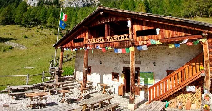
Rifugio
Alpino Casera Tartoi
Mobile: +39 351 6095199
e-mail: rifugiocaseratartoi@gmail.com / www.rifugiocaseratartoi.it
Località / Lage / Location: Forni di Sopra (UD)
Gruppo / Berggruppe / Moutain Range: Prealpi Carniche – Tudali, Tiarfin, Piova
Mappa / Karte/ Map: Tabacco - Fg 02 Forni di Sopra - Ampezzo Sauris Alta Val Tagliamento
Gestione / Betreiber / Management: Sebastiano e Girolamo Berto, Roberta Lazzari
Proprietà / Besitz / Ownership: Comune di Forni di Sopra
Periodi di apertura / Öffnung / Opening
Giugno - Settembre / Ottobre - Aprile (solo weekend meteo permettendo)
Juni – September / Oktober - April (nur am Wochenende, wetterabhängig)
June - September / October - April (only weekends, weather permitting)
Percorsi in quota / Höhenwege / Mountain Trails
Giro delle malghe fornesi: Varmost, Lavazeit, Tragonia; Forcella Rossa-Forcella Risumiela, Malga Tragonia, variante Altavia n. 6, Anello delle Dolomiti Friulane, Altavia di Forni di Sopra
Principali ascensioni / Hauptaufstiege / Main Ascents
Forcella Rossa, Crodon di Tiarfin
Accesso
Dalla Piazza del Comune, imboccare Via Novri, quindi la strada forestale che conduce alla Malga (segnavia 208) il cui primo tratto, fino a Duvies/ Sociaval, è comune a quello per Malga Tragonia.
Raggiunti gli stavoli di Puonsas si costeggia il Rio Tartojana per poi salire i tornanti del costone di Duvies. Al bivio, piegando a sinistra, si prosegue fino ai pascoli e all’anfiteatro della caratteristica malga. Il rifugio casera Tartoi è gestito durante la stagione estiva e invernale.
Wegbeschreibung
Vom Dorfplatz aus nehmen Sie die Via Novri, dann die Forststraße, die zur Almhütte führt (Wegweiser 208).
Der erste Abschnitt bis Duvies/ Sociaval ist identisch mit dem der zur Almhütte Tragonia führt. Nachdem Sie die Puonsas stavoli erreicht haben, geht es weiter entlang des Rio Tartojana und dann die Kehren des Duvies-Kamms hinauf. An der Kreuzung links abbiegen und weiter bis zu den Weiden und dem Amphitheater der charakteristischen Hütte.
Die Tartoi-Hütte wird sowohl im Sommer als auch im Winter bewirtschaftet.
How to get there
From Piazza del Comune, take Via Novri, then the forest road that leads to the malga (trail sign 208), the first stretch of which, up to Duvies/ Sociaval, is common to that for Malga Tragonia.
Once you reach the stavoli (typical mountain buildings) of Puonsas, you skirt the Rio Tartojana and then climb the hairpin bends of the Duvies ridge. At the junction, keep to the left, continue to the pastures and the amphitheatre of the characteristic malga.
The Rifugio Casera Tartoi is open during the summer and winter season.

1
1.587 m
Rifugio Flaiban-Pacherini
T: +39 0433 88555
e-mail: info@rifugioflaibanpacherini.it / www.rifugioflaibanpacherini.it
Località / Lage / Location: Forni di Sopra (UD)
Gruppo / Berggruppe / Moutain Range: Gruppo Pramaggiore in Alta Val di Suola
Mappa / Karte/ Map: Tabacco - Fg 02 Forni di Sopra - Ampezzo Sauris - Alta Val Tagliamento
Gestione / Betreiber / Management: Claudio Mitri
Proprietà / Besitz / Ownership: Comune di Forni di Sopra, in concessione a CAI XXX Ottobre di Trieste
Periodi di apertura / Öffnung / Opening
20 Giugno - 20 Settembre / 20 Juni - 20 September / 20 June - 20 September
Percorsi in quota / Höhenwege / Mountain Trails
Truoi dai Sclops, Via Alpina, Anello delle Dolomiti Friulane, Alta Via di Forni
Principali ascensioni / Hauptaufstiege / Main Ascents
Monte Pramaggiore, Torrione Comici (ferrata), Cima Val di Guerra
Accesso
Dal centro principale di Forni di Sopra (borgata Vico) si scende al ponte sul fiume Tagliamento da dove, nei pressi del centro sportivo (881 m, parcheggio, tabella segnaletica), parte una strada forestale chiusa al traffico che costeggia gli impianti da sci e raggiunge in 20 minuti la località Palas (slargo con tavoli). Qui arriva anche il sentiero diretto che si prende dalla frazione di Andrazza: sotto la borgata si parcheggia nei pressi del Tagliamento, si attraversa il fiume sul ponte stradale e presso la centrale idroelettrica si imbocca il sentiero sulla destra (837 m, indicazioni). Una mulattiera risale dolcemente il bosco e poi su terreno aperto e ghiaioso senza alcuna difficoltà lungo la val di Suola raggiunge il Rifugio a 1.587 metri (ore 2 complessive).
Wegbeschreibung
Vom Hauptort Forni di Sopra (Ortsteil von Vico) steigt man bis zur Brücke über den Fluss Tagliamento hinunter, wo in der Nähe des Sportzentrums (881 m, Parkplatz, ausgeschildert) eine für den Verkehr gesperrte Forststraße beginnt, die an den Skiliften entlangführt und in 20 Minuten die Ortschaft Palas (mit Tischen verbreitert) erreicht. Hier trifft auch der direkte Weg vom Weiler Andrazza ein: unterhalb des Weilers parkt man in der Nähe des Tagliamento, überquert den Fluss auf der Straßenbrücke und nimmt beim Wasserkraftwerk den Weg nach rechts (837 m, Beschilderung).
Ein Saumpfad führt leicht ansteigend durch den Wald und dann auf offenem, schottrigem Boden ohne Schwierigkeiten durch das Val di Suola bis zur Hütte auf 1.587 m (insgesamt 2 Stunden).
How to get there
From the main center of Forni di Sopra (hamlet of Vico), go down to the bridge over the Tagliamento River from where, near the sports center (881 m, parking, signage board), a forest road closed to traffic starts, skirting the ski lifts and reaching Palas (widening with tables) in 20 minutes. This is also where the direct trail arrives, which is taken from the locality of Andrazza: below the hamlet, park near the Tagliamento river, cross the river over the road bridge, and at the hydroelectric plant take the trail to the right (837 m, signs).
A mule track climbs gently up the forest and then on open, gravelly ground without any difficulty along the Suola valley reaches the mountain hut at 1,587 m (2 hours total).
MI RIFUGIO IN BIBLIOTECA
1.405 m

Rifugio Giaf
Mobile: + 39 338 7856338
e-mail: info@rifugiogiaf.it / www.rifugiogiaf.it
Località / Lage / Location: Forni di Sopra (UD)
Gruppo / Berggruppe / Moutain Range: Gruppo Cridola - Monfalconi
Mappa / Karte/ Map: Tabacco - Fg 02 Forni di Sopra - Ampezzo Sauris Alta Val Tagliamento
Gestione / Betreiber / Management: Alessandro Puntoriero / Marco Politi
Proprietà / Besitz / Ownership: Comune di Forni di Sopra, in concessione a CAI Forni di Sopra
Periodi di apertura / Öffnung / Opening
Giugno - Settembre / Juni - September / June - September
Percorsi in quota / Höhenwege / Mountain Trails
Anello delle Dolomiti Friulane, Alta Via di Forni, Alta Via n° 6 dei Silenzi, Truoi dai Sclops
Principali ascensioni / Hauptaufstiege / Main Ascents
Cridola, Monfalcon di Forni
Accesso
Dal centro di Forni di Sopra seguire la statale 52 del passo della Mauria per 3 km fino a località Chiandarens (962 m). Prendere a sinistra una stradina percorribile in auto fino al ponte sul Torrente Giaf. Proseguire a piedi lungo la strada forestale, oppure prendere il sentiero CAI 346 a quota 1107 m; in entrambi i casi calcolare 1 ora circa. Il Rifugio sorge su di un ripiano boscoso alla base del Coston di Giaf nell’omonima valle. L’ambiente è dolomitico con cime frastagliate e torrioni dalle pareti nude e lisce che contrastano con il verde dei boschi situati sui dolci versanti alla loro base.
Wegbeschreibung
Vom Zentrum von Forni di Sopra zu erreichen, indem der Bundesstraße 52 des Passo della Mauria für 3 km bis zur Ortschaft Chiandarens (962 m) gefolgt wird. Von hier aus beginnt links eine asphaltierte Straße, die mit dem Auto bis zur Brücke über den Wildbach Giaf zu befahren ist. Nach dem Parken des Autos geht es weiter zu Fuß, die Forststraße entlang, oder man nimmt dem Weg CAI 346 auf 1107 m Höhe; in beiden Fällen ist etwa 1 Stunde zu rechnen. Die Berghütte erhebt sich auf einer bewaldeten Ebene am Fuße des Coston di Giaf in gleichnamigem Tal.
How to get there
It can be reached from the town centre of Forni di Sopra, if you follow the 52 trunk road towards the Mauria Pass for 3 km until you reach Chiandarens (962 m). From here, there is a paved road on the left which can be used by cars up to the bridge on the Giaf Stream. When you have parked your car, you can walk along the forest road, or alternatively take the CAI 346 trail at 1107 m; both routes take approximately 1 hour. The mountain hut is situated above a forest area, at the base of the Coston di Giaf in the homonymous valley.
MI RIFUGIO IN BIBLIOTECA
1.466 m
2
Rifugio Som Picol
T: +39 351 5496373 / e-mail: sofiazamai@gmail.com / sompicol.fornidisopra@gmail.com www.facebook.com/sompicol
Località / Lage / Location: Forni di Sopra (UD)
Gruppo / Berggruppe / Moutain Range: Prealpi Carniche - Varmost
Mappa / Karte/ Map: Tabacco - Fg 02 Forni di Sopra - Ampezzo Sauris Alta Val Tagliamento
Gestione / Betreiber / Management: Sofia Zamai
Proprietà / Besitz / Ownership: Comune di Forni di Sopra
Periodi di apertura / Öffnung / Opening
Giugno - Settembre / Dicembre - Marzo (apertura subordinata al funzionamento degli impianti di risalita)
Juni – September / Dezember – März (Öffnungszeiten abhängig von Betriebszeiten der Lifte)
June - September/December - March (opening subject to the operation of the ski lifts)
Percorsi in quota / Höhenwege / Mountain Trails
Giro delle malghe: Varmost, Lavazeit, Tartoi
Principali ascensioni / Hauptaufstiege / Main Ascents
Clap Varmost, Monte Simon, Monte Crusicalas, Ferrata Adventure Climb Varmost
Accesso
A 300 m circa dal centro del paese, in direzione Passo Mauria, imboccare Via Chianeit sulla destra. Iniziare la salita fino al termine dell’asfalto quindi continuare seguendo il segnavia C.A.I. 207 per pista forestale a tratti erta o lungo la strada di recente costruzione. Attraversati i panoramici ghiaioni sotto i verticali dell’omonimo Clap si raggiunge il rifugio. Il rifugio è aperto stagionalmente in estate e inverno e può essere raggiunto anche con gli impianti di risalita.
Wegbeschreibung
Ca. 300 m von der Ortsmitte entfernt, in Richtung Passo Mauria, rechts in die Via Chianeit einbiegen. Bergauf bis zum Ende der Asphaltstraße fahren und folgen Sie dann dem Wegweiser des C.A.I. 207 auf einem teilweise steilen Waldweg oder auf der neu gebauten Straße. Nachdem man die Geröllhalden unter den Vertikalen des gleichnamigen Clap überquert hat, erreicht man die Berghütte. Die Berghütte ist saisonal im Sommer und Winter geöffnet und kann auch mit den Liften erreicht werden.
How to get there
At about 300 m from the town centre, in the direction of Passo Mauria, take Via Chianeit on the right. Start the climb to the end of the tarmac road, then continue following the C.A.I. forest trail 207, which at times is steep or along the newly built road.
After crossing the panoramic scree below the vertical cliffs of the homonymous Clap, you reach the refuge.
The refuge is open seasonally in summer and winter and can also be reached by ski lifts.

Profili carnici
Le Alpi Carniche si aprono allo sguardo con un ambiente aspro e selvaggio, meta ideale per gli amanti di una montagna incontaminata e ricca di opportunità, sia per i camminatori esperti che per quelli meno allenati.
Fa parte proprio di questo gruppo montuoso la cima più alta del Friuli Venezia Giulia: il grandioso massiccio del Monte Coglians, che dalla sua cima regala un eccezionale panorama sull’intera Carnia. Una serie di attrezzati rifugi consente di percorrere con relativa facilità numerosi sentieri ben segnalati e fa da appoggio a due percorsi in quota di straordinario interesse paesaggistico: la Traversata Carnica e l’Alta Via delle Alpi Carniche. Le Alpi Carniche sono attraversate anche dall’itinerario giallo della Via Alpina, che le percorre da Tolmezzo a Forni di Sopra per proseguire poi, oltre il Tagliamento, verso le Dolomiti friulane.
Alle pendici del Monte Tinisa: uno splendido itinerario escursionistico che racchiude
l’essenza delle Alpi Carniche. Il sentiero Tiziana Weiss è una lezione naturalistica di prim’ordine, grazie alle segnalazioni tabellari che spiegano il percorso e le sue peculiarità.
Via delle Malghe Carniche: 15 percorsi immersi nella natura delle Alpi Carniche seguendo le tradizioni culinarie della zona. La scoperta dell’arte della lavorazione dei prodotti caseari è il filo conduttore delle camminate sui sentieri a tema. Alcuni dei percorsi sono percorribili anche in mountain-bike o a cavallo.

Profile Des Karn
Die Karnischen Alpen öffnen sich dem Blick mit einer herben und wilden Landschaft, ein ideales Ziel für die Liebhaber der unberührten Bergwelt, die reich an Möglichkeiten sowohl für die Wanderexperten als auch für die weniger trainierten ist.
Gerade zu dieser Gebirgsgruppe gehört der höchste Gipfel des Friaul-Julisch Venetien: das grandiose Massiv des Monte Coglians, der von seinem Gipfel ein aufsehenerregendes Panorama über das gesamte Karn schenkt.
Eine Reihe gut eingerichteter Berghütten ermöglicht es, relativ leicht die zahlreichen gut gekennzeichneten Pfade zu bewältigen und ist Ausgangsstelle für zwei Höhenstrecken von außerordentlichen landschaftlichen Interesse: die Traversata Carnica und die Alta via delle Alpi Carniche. Die Karnischen Alpen werden ferner von der gelben Route, der Via Alpina durchquert, die von Tolmezzo nach Forni di Sopra führt und dann nach dem Tagliamento in
Profile of the Carnia Area
The Carnic Alps reveal themselves as a bitter and wild environment, an ideal location for those who love uncontaminated mountains that are full of opportunities for both expert hikers and those with less experience.
It is in this mountain range that Friuli Venezia Giulia’s highest peak rises: the majestic massif of the Monte Coglians, whose peak provides an exceptional view of the entire Carnia area. A number of well-equipped mountain huts, allow you to travel with relative ease along the numerous well-marked trails and there are two extraordinarily beautiful panoramic mountain trails: the Traversata Carnica and the Alta Via delle Alpi Carniche. The Carnic Alps are also crossed by the yellow trail of the Via Alpina, which travels across them from Tolmezzo to Forni di Sopra to then continue
Richtung der Friauler Dolomiten.
An den Hängen des Monte Tinisa eine herrliche Wanderstrecke, die die Essenz der Karnischen Alpen einschließt.
Die Route Tiziana Weiss ist ein naturkundlicher Lehrgang erster Güte, dank der Hinweistafeln die den Weg und seine Besonderheiten erklären.
Via delle Malghe Carniche (Weg der Almen des Karn): 15 Strecken inmitten der Natur der Karnische Alpen, den kulinarischen Traditionen der Region folgend. Das Kennenlernen der Kunst des Käserhandwerks zieht sich als roter Faden durch das Angebot an thematischen Wanderungen und Ausflügen. Einige der Strecken sind auch mit dem Mountainbike oder zu Pferd zu bewältigen.
beyond the Tagliamento River towards the Friulian Dolomites.
On the slopes of Monte Tinisa lies a wonderful hiking trail that captures the essence of the Carnic Alps. The Tiziana Weiss trail is a first-class nature lesson, thanks to its information boards which provide details about the route and its distinguishing features.
Via delle Malghe Carniche: 15 trails immersed in the nature of the Carnic Alps, which adhere to the local culinary traditions. Discovering the art of how dairy products are made is the main theme of these themed trail walks. Mountain bikes or horses can also be used on some of the trails.
Rifugio Tita Piaz
Mobile: +39 331 3568500
e-mail: info@rifugiotitapiaz.com / www.rifugiotitapiaz.com

Località / Lage / Location: Passo Pura - Ampezzo (UD)
Gruppo / Berggruppe / Moutain Range: Prealpi Carniche
Mappa / Karte/ Map: Tabacco - Fg 02 Forni di Sopra Ampezzo - Sauris Alta Val Tagliamento
Gestione / Betreiber / Management: Massimo Cecotti
Proprietà / Besitz / Ownership: Comune di Ampezzo
Periodi di apertura / Öffnung / Opening
Maggio - Ottobre / Mai - Oktober / May - October
Percorsi in quota / Höhenwege / Mountain Trails
Sentiero T. Weiss, Carnia Trekking, Sentiero Flobia, Anello delle Creste Via ferrata: le creste del cielo al monte Tinisa 2100 m (EEA)
Principali ascensioni / Hauptaufstiege / Main Ascents
Monti Tinisa, Nauleni e Sesilis
Accesso
Situato in una bellissima posizione sul Passo Pura, tra i Monti Nauleni e Tinisuta, il rifugio è raggiungibile dalla frazione La Maina di Sauris, seguendo la strada sulla diga del Lumiei che dopo diversi tornanti conduce al Passo e quindi al rifugio. Oppure da Ampezzo (statale carnica 52), al km 35,9 presso l’albergo Aria Pura, svoltare a destra per il Passo Pura. Disponibili 12 camere doppie, una tripla e una quadrupla.
Wegbeschreibung
Die Hütte befindet sich in schöner Lage auf dem Pura-Pass, zwischen den Bergen Nauleni und Tinisuta. Man erreicht sie von der Ortschaft La Maina di Sauris aus, indem man der Straße über den LumieiStaudamm folgt, die nach mehreren Kehren zum Pass und dann zur Hütte führt. Oder von Ampezzo aus (Karnische Staatsstraße 52) biegt man bei Kilometer 35,9 auf Höhe des Hotels Aria Pura rechts zum Pura-Pass ab. Es stehen 12 Doppel-, ein Dreibett- und ein Vierbettzimmer zur Verfügung.
How to get there
Located in a beautiful position on the Pura Pass, between the Nauleni and Tinisuta Mountains, the refuge can be reached from the hamlet of La Maina di Sauris, following the road over the Lumiei dam, which after several hairpin bends leads to the Pass and then to the refuge. Or from Ampezzo (Carnic Highway 52), at km 35.9 at the Aria Pura hotel, turn right for Passo Pura. Twelve double, one triple and one quadruple rooms available.
MI RIFUGIO IN BIBLIOTECA
1.420 m

Rifugio Monte Pura
Mobile: +39 377 3276031
e-mail: rifugiomontepura@gmail.com 5
Località / Lage / Location: Passo Pura - Ampezzo (UD)
Gruppo / Berggruppe / Moutain Range: Prealpi Carniche
Mappa / Karte/ Map: Fg 02 Forni di Sopra Ampezzo - Sauris Alta Val Tagliamento
Gestione / Betreiber / Management: La Fenice di Rabassi Davide
Proprietà / Besitz / Ownership: Comune di Ampezzo
Periodi di apertura / Öffnung / Opening
Maggio – Ottobre / Mai – Oktober / May - October
Percorsi in quota / Höhenwege / Mountain Trails
Sentiero T. Weiss, Carnia Trekking, Sentiero Flobia, Anello delle Creste Via ferrata: le creste del cielo al monte Tinisa 2100 m (EEA)
Principali ascensioni / Hauptaufstiege / Main Ascents
Monti Tinisa, Nauleni e Sesilis
Accesso
Il rifugio monta Pura, poco Distante dal Rifugio Tita Piaz, è immerso in un ambiente incontaminato e offre una vista panoramica sulla vallata di Sauris. È il punto di partenza perfetto per numerose passeggiate ed escursioni. Si può raggiungere dalla frazione La Maina di Sauris, seguendo la strada sulla Diga del Lumiei verso il Passo oppure, in alternativa, da Ampezzo (statale carnica 52), al km 35,9 presso l’Osteria del Pura, si svolta a destra per Passo Pura.
Wegbeschreibung
Die Monte-Pura-Hütte, nicht weit von der Tita-Piaz-Hütte entfernt, liegt inmitten einer unberührten Umgebung und bietet einen Panoramablick auf das Sauris-Tal. Sie ist der ideale Ausgangspunkt für zahlreiche Spaziergänge und Wanderungen. Man erreicht sie von der Ortschaft La Maina di Sauris aus, indem man der Straße über den Lumiei-Staudamm in Richtung Pass folgt. Alternativ kann man von Ampezzo aus (Karnische Staatsstraße 52) bei Kilometer 35,9 an der Osteria del Pura rechts in Richtung Passo Pura abbiegen.
How to get there
The Pura mountain hut, not far from the Tita Piaz hut, is nestled in an unspoiled environment and offers panoramic views of the Sauris valley. It is the perfect starting point for numerous walks and hikes. It can be reached from the hamlet of La Maina di Sauris, following the road over the Lumiei Dam toward the Pass or, alternatively, from Ampezzo (Carnic Highway 52), at km 35.9 at the Osteria del Pura, turn right for Passo Pura.
m

Rifugio Chiadinas
Mobile: +39 329 8976452
e-mail: info@rifugiochiadinas.com / www.rifugiochiadinas.com
Località / Lage / Location: Comeglians (UD)
Gruppo / Berggruppe / Moutain Range: Alpi Carniche / Monte Crostis
Mappa / Karte/ Map: Tabacco - Fg 09 Alpi Carniche
Gestione / Betreiber / Management: Martina Zaro
Proprietà / Besitz / Ownership: Privata
Periodi di apertura / Öffnung / Opening
Giugno - Settembre / Juni - September / June - September
Percorsi in quota / Höhenwege / Mountain Trails
Strada “Panoramica delle Vette”, Carnia Trekking
Principali ascensioni / Hauptaufstiege / Main Ascents
Monte Crostis, Rifugio Marinelli
Accesso
A piedi: da Tualis seguendo sentiero CAI 151 (ore 3.30-4), da Givigliana sentiero CAI 151 (ore 3.30), da Collina sentieri CAI 150 e 174 (ore 3.30-4) e da Ravascletto CAI 153 (ore 4).
In auto, moto o bici: da Comeglians in direzione Tualis seguendo la “Panoramica delle Vette”, oppure da Ravascletto fino a Casera Valsecca su strada asfaltata, per proseguire su strada sterrata verso Casera Tarondon, Tarondut e Crostis.
Wegbeschreibung
Zu Fuß: ab Tualis dem Weg CAI 151 folgen (3.30-4 Stunden), ab Givigliana Weg CAI 151 (3.30 Stunden), ab Collina Weg CAI 150 und 174 (3.30-4 Stunden) und ab Ravascletto CAI 153 (4 Stunden). Mit dem auto, Motorrad oder Fahrrad: ab Comeglians in Richtung Tualis entlang der Höhenstraße „Panoramica delle Vette“, oder ab Ravascletto bis Casera Valsecca auf der asphaltierten Straße, dann weiter auf der Schotterstraße in Richtung Casera Tarondon Tarondut und Crostis.
How to get there
On foot: from Tualis, via the CAI 151 trail (3.5 - 4 hours), from Givigliana via the CAI 151 trail (3.5 hours), from Collina via the CAI 150 and 174 trails (3.5 - 4 hours) and from Ravascletto via the CAI 153 trail (4 hours). By car, motorbike or bike: from Comeglians, head towards Tualis, following the “Panoramica delle Vette”, or from Ravascletto to Casera Valsecca on a paved road. Then continue on the dirt road towards Casera Tarondon, Casera Tarondut and Casera Crostis.
1.955 m
Temporaneamentechiuso Vorübergehendgeschlossen Temporarilyclosed
Rifugio Lambertenghi Romanin
Chiuso / Geschlossen / Closed

Località / Lage / Location: Collina di Forni Avoltri (UD)
Gruppo / Berggruppe / Moutain Range: Gruppo Coglians Al Passo Volaia
Mappa / Karte/ Map: Tabacco - Fg 01 Sappada - S. Stefano Forni Avoltri
Gestione / Betreiber / Management:
Proprietà / Besitz / Ownership: Comune di Forni Avoltri
Periodi di apertura / Öffnung / Opening
Chiuso / Geschlossen / Closed
Percorsi in quota / Höhenwege / Mountain Trails
Sentiero Spinotti, Carnia Trekking, Traversata Carnica, Alta Via Alpi Carniche, Trekking delle due Nazioni
Principali ascensioni / Hauptaufstiege / Main Ascents
Monte Coglians
Accesso
Il rifugio è situato sul Passo Volaia, poco distante dall’omonimo laghetto alpino, fra le svettanti pareti del Coglians e del Capolago. Dal Rifugio Tolazzi (3 km dopo la frazione di Collina) per sentiero CAI 144 (ore 2).
Dal Rifugio Marinelli per sentiero attrezzato Spinotti n. 145 (ore 2) con idonea attrezzatura.
Servizi Corsi di arrampicata, corsi di fotografia, corsi di yoga, corsi di avvicinamento all’alpinismo, centri estivi per ragazzi, Paleotrek Volaia.
Wegbeschreibung
Die Berghütte liegt am Passo Volaia, nicht weit vom gleichnamigen Bergsee entfernt, zwischen den emporragenden Wänden des Coglians und des Capolago von der Berghütte Tolazzi (3 km nach dem Ortsteil von Collina) über den Wanderpfad CAI 144 (2 Stunden). Ab der Berghütte Marinelli zum befestigten Wanderweg. Leistungen Kletterkurs, Fotokurse, Jogakurse, Einsteigerkurse in den Bergsport, Sommerlager für Jugendliche, Paleotrek Volaia.
How to get there
The mountain hut is located on the Volaia Pass, between the Coglians and Capolago cliff faces and a short distance from the Volaia alpine pond.
From the Tolazzi Mountain Hut (3 km after Collina), take the CAI 144 trail (2 h).
From the Marinelli Mountain Hut, take the Spinotti n. 145 difficult trail (2 h) which requires suitable equipment. Services Climbing classes, photography classes, yoga classes, introductory mountaineering classes, day camps for children, PaleoTrek Volaia (palaeontology tour of the Volaia Pass).
MI RIFUGIO IN BIBLIOTECA
1.350 m

Rifugio Edoardo Tolazzi
Mobile: +39 350 5011795
e-mail: rifugiotolazzi22@gmail.com 1
Località / Lage / Location: Loc. Plan di Bos Collina di Forni Avoltri (UD)
Gruppo / Berggruppe / Moutain Range: Gruppo Coglians Al Plan Val Di Bos
Mappa / Karte/ Map: Tabacco - Fg 09 Alpi Carniche
Gestione / Betreiber / Management: Tamussin Martina e Narduzzi Mattia
Proprietà / Besitz / Ownership: Consorzio privato Collina
Periodi di apertura / Öffnung / Opening
Da fine maggio ai primi di novembre
Ende Mai bis Anfang November
End of May Beginning of November
Percorsi in quota / Höhenwege / Mountain Trails
Carnia Trekking, Traversata carnica, Alta Via Carnica
Principali ascensioni / Hauptaufstiege / Main Ascents Coglians, M. Volaia
Accesso
In auto, moto o bici: da Forni Avoltri una carrozzabile conduce a Collina e successivamente a località Plan Val di Bos, dove il rifugio è posto. A piedi: dal Rifugio Marinelli lungo il sentiero CAI 143 e dal Rifugio Lambertenghi lungo il sentiero CAI 144.
Servizi Area camping, escursioni guidate. Servizio Wi-Fi.
By car, motorbike or bike: Take the road that leads from Forni Avoltri to Collina and then to Plan Val di Bos, where the mountain hut is situated. On foot: Walk along the CAI 143 trail from the Marinelli Mountain Hut, and the CAI 144 trail from the Lambertenghi Mountain Hut. Services Camping area, guided hikes. Wi-Fi service. 12 1
Wegbeschreibung
Mit dem Auto, Motorrad oder Fahrrad: ab Forni Avoltri füht eine Straße nach Collina und anschließend nach Plan Val di Bos, wo sich die Berghütte befindet. Zu Fuß: von der Berghütte Marinelli dem Weg CAI 143 folgen und von der Berghütte Lambertenghi entlang des Wanderwegs CAI 144. Leistungen Camping-Bereich, geführte Exkursionen. WLANVerbindung.
How to get there
MI RIFUGIO IN BIBLIOTECA
Mobile: +39 339 5356363
e-mail: cate_selva@libero.it

Località / Lage / Location: Forcella Morarêt – Paluzza – Forni Avoltri (UD)
Gruppo / Berggruppe / Moutain Range: Gruppo Coglians, Alla Forcella Morarêt
Mappa / Karte/ Map: Tabacco - Fg 09 Alpi Carniche
Gestione / Betreiber / Management: Giorgio Tamussin / Caterina Tamussin
Proprietà / Besitz / Ownership: Società Alpina Friulana (Sez. CAI di Udine)
Periodi di apertura / Öffnung / Opening
Giugno - Ottobre / Juni - Oktober/ June - October
Percorsi in quota / Höhenwege / Mountain Trails
Carnia Trekking, Alta Via delle Alpi Carniche, Via Alpina, Traversata Carnica
Principali ascensioni / Hauptaufstiege / Main Ascents
Coglians, Crostis, Floriz, Chianevate
Accesso
Dal versante di Forni Avoltri: dal Rif. Tolazzi su strada sterrata lungo segnavia CAI 143, si giunge al Rif. Marinelli in 2 ore.
Dal versante di Paluzza: lungo la SS52 bis per Passo M.te Croce Carnico, si prende la strada sterrata a sinistra appena prima del confine. Seguire il segnavia CAI 146 della Traversata Carnica. La strada diventa subito sentiero e in 2.30 ore porta al rifugio.
Alternativa dal Passo di Monte Croce Carnico sui sentieri CAI 146/148, il tratto attrezzato La Scaletta e i Monumenz, in 3 ore passando accanto al laghetto Plotta.
Wegbeschreibung
Vom Hang in Forni Avoltri: von der Berghütte Tolazzi auf der Schotterstraße entlang des Wegs CAI 143 erreicht man die Berghütte Marinelli in 2 Stunden.
Vom Hang in Paluzza: über die SS52 bis zum Passo M.te Croce Carnico, links vor der Grenze die Schotterstraße nehmen. Der Wegmarke CAI 146 der Traversata Carnica folgen. Wanderweg. 2.30 Stunden zur Berghütte.
Vom Pass Monte Croce Carnico geht über den Weg 146/148 und den befestigten Abschnitt La Scaletta und Monumenz, vorbei am kleinen See Plotta, Dauer 3 Stunden.
How to get there
From the Forni Avoltri direction: take the CAI 143-signposted dirt road from the Tolazzi Mountain Hut, and you will reach the Marinelli Mountain Hut in 2 hours.
From the Paluzza direction: take the SS52-bis road towards the Plöcken Pass and take the dirt road on the left just before you reach the border. Follow the CAI 146 signposts for the Traversata Carnica. Trail to reach the mountain hut in 2.5 hours. Alternative: from the Plöcken Pass on the CAI 146/148 trails. This is the difficult “La Scaletta” pass where equipment is required and the Monumenz. You will arrive in 3 hours.

1.250 m
2
Rifugio Grauzaria
Mobile: +39 331 8598861
e-mail: info@rifugiograuzaria.it / www.rifugiograuzaria.it
Località / Lage / Location: Moggio Udinese (UD)
Gruppo / Berggruppe / Moutain Range: Alla Conca di Flop, Valle Aupa di Moggio Udinese
Mappa / Karte/ Map: Tabacco - Fg 018 Alpi Carniche Orientali Canal del Ferro
Gestione / Betreiber / Management: Gian Battista Bugna / Cristina Garelli
Proprietà / Besitz / Ownership: CAI Moggio Udinese
Periodi di apertura / Öffnung / Opening
01 Giugno - 30 Settembre / 1 June - 30 September / 1. Juni bis 30. September
Percorsi in quota / Höhenwege / Mountain Trails
Via Alpina, Carnia Trekking, Alta Via d’Incarojo, Alta Via Alpi Carniche
Principali ascensioni / Hauptaufstiege / Main Ascents
Creta Grauzaria, Sernio
Accesso
Da Moggio si segue per circa per 8,5 Km la strada che percorre la Valle Aupa (SP 112); qualche chilometro dopo il paesino Grauzaria, sulla destra orografica, prima di attraversare il ponte sul rio Flop (primo piccolo parcheggio), si imbocca la stradina asfaltata che conduce alla località “Case Nanghets” (714 m.), da qui (secondo parcheggio) si prosegue a piedi lungo il sentiero 437 che conduce al rifugio.
Wegbeschreibung
Von Moggio aus folgt man der Straße, die durch das Aupa-Tal führt (SP 112), für etwa 8,5 km; einige Kilometer nach dem Dorf Grauzaria, auf der orographisch rechten Seite, bevor man die Brücke über den Flop-Bach überquert (erster kleiner Parkplatz), nimmt man die asphaltierte Straße, die zur Ortschaft „Case Nanghets“ (714 m.) führt; von hier aus (zweiter Parkplatz) geht man zu Fuß weiter auf dem Weg 437, der zur Hütte führt.
How to get there
From Moggio, follow the road that runs through the Aupa Valley (SP 112) for about 8.5 km; a few kilometers after the small village Grauzaria, on the orographic right, before crossing the bridge over the Flop stream (first small parking lot), take the small asphalt road that leads to the locality “Case Nanghets” (714 m.), from here (second parking lot) continue on foot along path 437 that leads to the refuge.
1.587 m

Rifugio Gortani
Mobile: +39 331 7907427
Località / Lage / Location: Podrauna Frazione Ugovizza, Malborghetto-Valbruna
Gruppo / Berggruppe / Moutain Range:
Mappa / Karte/ Map: Tabacco - Fg 019 Alpi Giulie Occidentali Tarvisiano
Gestione / Betreiber / Management: Angela Virgallito
Proprietà / Besitz / Ownership: Comune di Malborghetto Valbruna
Periodi di apertura / Öffnung / Opening
Tutto l’anno, giorni di chiusura martedi e mercoledì Ganzjährig, Dienstag und Mittwoch geschlossen
All year round, Tuesday and Wednesday Closed
Percorsi in quota / Höhenwege / Mountain Trails
Puanina Tour
Principali ascensioni / Hauptaufstiege / Main Ascents
Monte Oisterning, Monte Cocco, Cima Bella
Dalla strada statale a Ugovizza seguire i cartelli Val Uque e Rifugio Gortani salendo per c.ca 4 km la carrozzabile. Alla cappelletta (cartello) girare a sinistra e dopo un km lasciare l’auto al parcheggio. Ancora 500 metri su strada asfaltata e si giunge al Rifugio. E’ raggiungibile direttamente in auto. Accesso
Wegbeschreibung
Von der SS bis in Ugovizza die Anzeigen “Val Uque” und “Rifugio Gortani” folgen (etwa 4km Fahrweg). An eine kleine Kapelle (Anzeige) links fahren un nach 1 km das Auto parken und noch 500 m auf asfalierte Straße zu Fuß gehen. Es ist direkt mit dem Auto erreichbar.
How to get there
From the SS in Ugovizza follow the signs to“Val Uque” and “Rifugio Gortani” (about 4 km by car). Close to small chapel turn left. After 1 km, park the car. Follow the road on foot for about 500m till you arrive at the Rifugio Gortani. It is accessible directly by car.

1.406 m
3
Rifugio F.lli Nordio E R. Deffar
Mobile: +39 320 8151052
e-mail: lianeke@libero.it
Località / Lage / Location: Malborghetto Valbruna (UD)
Gruppo / Berggruppe / Moutain Range: Alta Val Uque
Mappa / Karte/ Map: Tabacco - Fg 019 Alpi Giulie Occidentali Tarvisiano
Gestione / Betreiber / Management: Liana Spitali
Proprietà / Besitz / Ownership: Sezione CAI Trieste
Periodi di apertura / Öffnung / Opening
Da metà giugno a fine settembre tutti i giorni. Chiuso novembre e aprile. Nei fine settimana di beltempo, gradita la prenotazione / Von Mitte Juni bis Ende September täglich. Im November und April geschlossen. An Wochenenden mit gutem Wetter sind Reservierungen willkommen / From mid-June to the end of September every day. Closed November and April. On weekends with good weather, reservations are welcome
Percorsi in quota / Höhenwege / Mountain Trails
Traversata carnica
Principali ascensioni / Hauptaufstiege / Main Ascents
Monte Osternig, Monte Acomizza, Monte Sagran
Accesso
Dalla strada statale a Ugovizza seguire i cartelli Val Uque salendo per ca. 7 km la carrozzabile fino al parcheggio. Per raggiungere il rifugio si può percorrere la strada forestale (2 km con 200 mt di dislivello) o il sentiero, rispettivamente circa 45 minuti e 25 minuti.
Wegbeschreibung
Von der SS bis in Ugovizza die Anzeigen “Val Uque” folgen (etwa 7km Fahrweg). Um die Berg Hutte zu erreichen, können Sie die Forststraße (2 km mit 200 m Höhenunterschied) oder den Weg ca. 45 Minuten bzw. 25 Minuten nehmen.
How to get there
From the SS in Ugovizza follow the signs to“Val Uque” (about 7 km by car). To reach the mountain hut you can take the forest road (2 km with 200 meters of altitude difference) or the path, respectively about 45 minutes and 25 minutes.
1.539 m

Rifugio Pietro Fabiani
Mobile: +39 366 7863211 / Mobile: +39 331 3672786
e-mail: rifugiofabiani1@gmail.com 1
1
Località / Lage / Location: Paularo (UD)
Gruppo / Berggruppe / Moutain Range: Gruppo Cuestalta, Pecol di Chiaula Alta
Mappa / Karte/ Map: Tabacco - Fg 09 Alpi Carniche
Gestione / Betreiber / Management: Nino e Tiziana Blanzan
Proprietà / Besitz / Ownership: Regione FVG
Periodi di apertura / Öffnung / Opening
Giugno - Settembre e da Ottobre in poi da venerdì a domenica
Juni - September, ab Oktober: von Freitag bis Sonntag
June - September, October onwards: from Friday to Sunday
Percorsi in quota / Höhenwege / Mountain Trails
Carnia Trekking, Traversata Carnica
Principali ascensioni / Hauptaufstiege / Main Ascents
Cuestalta, Lodin
Accesso
Da Paularo proseguire per 6 km fino a Casera Ramaz e parcheggiare l’auto. Si prende il sentiero CAI 454 e dopo aver superato Casera Lodin si giunge in 2 ore al Rifugio.
Wegbeschreibung
Ab Paularo weitere 6 km bis nach Casera Ramaz und dort das Auto abstellen. Den Weg CAI 454 nehmen und nach der Casera Lodin erreicht man die Berghütte innerhalb von 2 Stunden.
How to get there
Continue for 6 km from Paularo, until you reach Casera Ramaz and park your car. Take the CAI 454 trail and once you have passed Casera Lodin, you will reach the Mountain Hut in 2 hours.
1.770 m

Rifugio F.lli De Gasperi
Mobile: +39 348 2208808
e-mail: info@rifdegasperi.it / www.rifdegasperi.it
Località / Lage / Location: Prato Carnico (UD)
Gruppo / Berggruppe / Moutain Range: Gruppo Terze Clap Siera, Al Clap Grande
Mappa / Karte/ Map: Tabacco - Fg 01 Sappada - S. Stefano Forni Avoltri
Gestione / Betreiber / Management: Anna Mainardi
Proprietà / Besitz / Ownership: CAI Tolmezzo
Periodi di apertura / Öffnung / Opening
Giugno (nei weekend) - Settembre / Juni - September / June - September
Percorsi in quota / Höhenwege / Mountain Trails
Carnia Trekking, Sentiero Corbellini, Alta via n.6 delle Dolomiti, Giro dell’Arco
Principali ascensioni / Hauptaufstiege / Main Ascents
Creta Forata, Creton di Culzei, Clap Grant
Accesso
Dalla Val Pesarina: lasciare l’auto presso il Bar Centro Fondo (m. 1236) e seguire il sentiero CAI 201 (2 ore).
Dalla SS di Forcella Lavardet: dopo Pian di Casa (m 1423) seguire la strada forestale fino a Malga Mimoias e da qui per i sentieri CAI 203 e 201 (2 ore).
Da Sappada: sentiero CAI 316 partendo da Granvilla attraverso il Passo Siera (EE - 3.30 ore).
Wegbeschreibung
Vom Val Pesarina: das Auto an der Bar Centro Fondo (1236 m) lassen und dem Wanderweg CAI 201 folgen (2 Stunden).
Von der SS der Forcella Lavardet: nach der Ebene Pian di Casa (1423 m) der Forststraße bis zur Mimoias Alm folgen und von hier aus den Wegen CAI 203 und 201 (2 Stunden).
Ab Sappada: Weg CAI 316 ab Granvilla über den Passo Siera (EE - 3.30 Stunden).
How to get there
From Val Pesarina: leave your car at the Centro Fondo Coffee Bar (1236 m) and follow the CAI 201 trail (2 hours).
From the Forcella Lavardet trunk road: after you reach Pian di Casa (1423 m), follow the forest road until the Mimoias alpine pasture and from there, the CAI 203 and 201 trails (2 hours).
From Sappada: Start from Granvilla and take the CAI 316 trail via the Siera Pass (EE - skilled hikers - 3.5 hours).
MI RIFUGIO IN BIBLIOTECA
1.093 m

Rifugio Monte Talm
Mobile: +39 349 0862166
e-mail: silvanosacilotto@gmail.com
Località / Lage / Location: Prato Carnico (UD)
Gruppo / Berggruppe / Moutain Range: Gruppo Terze - Clap - Siera, agli Stavoli di Rùnchias
Mappa / Karte/ Map: Tabacco - Fg 01 Sappada - S. Stefano Forni Avoltri
Gestione / Betreiber / Management: Sezione CAI Ponte di Piave/Sagareda - TV
Proprietà / Besitz / Ownership: Sezione CAI Ponte di Piave/Sagareda - TV
Periodi di apertura / Öffnung / Opening
A richiesta in autogestione da gruppi organizzati, famiglie, associazioni
Auf Anfrage in Selbstversorgung, organisierte Gruppen, Familien, Vereine Self-managed on request by organised groups, families and associations
Percorsi in quota / Höhenwege / Mountain Trails
Traversata: Cima Sappada per Chiampizzulon - Sella Tuglia per Rif. Chiampizzulon
Principali ascensioni / Hauptaufstiege / Main Ascents
Talm, Pleros
Accesso
Da Sostasio (frazione di Prato Carnico): seguire la rotabile, dapprima asfaltata poi parzialmente sterrata, che porta alla frazione di Luch e dopo circa 4 km al rifugio.
Da Prato Carnico: raggiungere con un automezzo la frazione di Còi e poi nei pressi dell’acquedotto, a monte dell’abitato, seguire il sentiero CAI 226 che porta attraverso un ripido bosco nei pressi del rifugio (1.30 ore).
Wegbeschreibung
Ab Sostasio (Ortsteil von Prato Carnico): der zunächst asphaltierten Schotterstraße folgem, die bis zum Ortsteil Luch und dann nach etwa 4 Stunden zur Berghütte führt.
Ab Prato Carnico: mit dem Fahrzeug bis zum Ortsteil Còi und dann in Richtung des Aquädukts vor der Ortschaft fahren, dann den Weg CAI 226 nehmen, der durch einen steilen Wald in die Nähe der Berghütte führt (1.30 Stunden).
How to get there
From Sostasio (Prato Carnico village): follow the road which is at first paved and then partiallyunpaved, w hich leads to Luch village and then the mountain hut, around 4 kilometres later.
From Prato Carnico: reach the village of Còi by vehicle and then follow the CAI 226 trail near the acqueduct, upstream from the town, which leads through a steep forest near to the mountain hut (1.5 hours).
Chiampizzulon

Località / Lage / Location: Loc. Chiampizzulon, Rigolato (UD)
Gruppo / Berggruppe / Moutain Range: Gruppo Dolomiti Pesarine
Mappa / Karte/ Map: Tabacco - Fg 01 Sappada - S. Stefano Forni Avoltri
Gestione / Betreiber / Management: Df gestione snc di Bolt Debora & C
Proprietà / Besitz / Ownership: Comune di Rigolato
Periodi di apertura / Öffnung / Opening
Apertura fine maggio primi di giugno fino a fine settembre
Geöffnet Ende Mai, Anfang Juni bis Ende September
Open end of May beginning of June until the end of September
Percorsi in quota / Höhenwege / Mountain Trails
Anello dei Piani di Vas
Principali ascensioni / Hauptaufstiege / Main Ascents
Monte Tuglia, Monte Cimon, Creta Forata, Monte Pleros
Accesso
Da Rigolato: rotabile fino a Piani di Vas, poi sentiero CAI 228a e 228, (0,45 - 1 ora di cammino).
Da Forni Avoltri: Sentiero CAI 229 per Casera Col di Mezzodì si alla Sella di Tuglia (ore 2.15); sentieri in quota 227 e 228 e raggiungere il rifugio in 1,15 ore. Da Cima Sappada: in prossimità del M. Siera sentiero CAI 230 fino a Malga Tuglia; continuare fino a Sella Tuglia, poi segnavia CAI 227. Dopo pochi metri si giunge ad una biforcazione ove a destra c’è il sentiero panoramico. Proseguendo verso ovest si percorrono i sentieri CAI 227 e 228 passando per Casera Campiut (2 ore).
Wegbeschreibung
Ab Rigolato: die Straße hinauf bis Piani di Vas, von hier Wanderweg CAI 228a und 228, (0.45 oder 1 Stunde). Ab Forni Avoltri: dem Weg CAI 229 nach Casera Col di Mezzodì folgen zur Sella di Tuglia (2.15 Stunden). Von hier aus geht es über die Wege 227 und 228 weiter (1.15 Stunden). Ab Cima Sappada: in der Nähe des M. Siera dem Wanderweg CAI 230 bis zur Tuglia Alm folgen, ab hier weiter bis zur Sella Tuglia und dann der Wegmarke CAI 227 folgen. Weiter nach Westen geht es über die Wege CAI 227 und 228 vorbei an Casera Campiut (2 Stunden).
How to get there
From Rigolato: Climb up via the road until you reach Piani di Vas. From here, CAI 228a and 228 trails (0.45 h or 1 hour respectively). From Forni Avoltri: CAI 229 trail for Casera Col di Mezzodì, until you reach the Sella di Tuglia (2.25 h). From here, cross the mountains (trails 227 and 228) and, in 1 hour and 15 minutes, you will reach the mountain hut. From Cima Sappada: CAI 230 path that runs near to Monte Siera, up to the Tuglia Alpine Pasture. Reach Sella Tuglia and turn onto the CAI 227 signposted trail. Head west along the CAI 227 and 228 trails, via Casera Campiut (2 h).

2.164 m
1
Rifugio Calvi
T: +39 0435 469232 / Mobile: +39 340 5626469 / +39 339 5620276
e-mail: rifugio_pfcalvi@libero.it / www.rifugiocalvi.com
Località / Lage / Location: Loc. Alta Val Sesis, Sappada (UD)
Gruppo / Berggruppe / Moutain Range: Gruppo Peralba-Chiadenis-Avanza
Mappa / Karte/ Map: Tabacco - Fg 01 Sappada, Santo Stefano, Forni Avoltri
Gestione / Betreiber / Management: Famiglia Galler e Pachner
Proprietà / Besitz / Ownership: CAI - Sezione di Sappada
Periodi di apertura / Öffnung / Opening
Giugno - Settembre / Juni - September / June - September
Percorsi in quota / Höhenwege / Mountain Trails
Travesata Carnica, Volaja-Hutte, Rifugio Lambertenghi, Rifugio Hochweißsteinhaus
Principali ascensioni / Hauptaufstiege / Main Ascents
Monte Peralba, Pic Chiadenis, Monte Chiadenis, Monte Avanza
Accesso
Da Cima Sappada si raggiunge in macchina il bivio posto 500 mt. prima del Rifugio Sorgenti del Piave. Si prosegue poi a piedi, lungo il sentiero n.132 per raggiungere il Rifugio Calvi in circa un’ora di cammino.
Wegbeschreibung
Ab Cima Sappada erreichbar mit dem Auto bis der Abzweigung 500mt vor Berghütte Sorgenti del Piave. Von hier weiter zu Fuß dem Weg CAI 132 bis zur Berghütte Calvi; Wegdauer etwa 1 Stunde.
How to get there
From Cima Sappada follow the road by car and reach the junction just 500 mt before the Rifugio Sorgenti del Piave.
Then follow on foot the CAI TRAil n°132 and in about one hour you will reach the mountain Hut.
1.575 m

Rifugio Monte Ferro
Mobile: +39 392 9733806
www.rifugiomonteferro.it
Località / Lage / Location: Loc. Oschtans, Sappada (UD)
Gruppo / Berggruppe / Moutain Range: Monte Rinaldo
Mappa / Karte/ Map: Tabacco - Fg 01 Sappada, Santo Stefano, Forni Avoltri
5
Accesso
Gestione / Betreiber / Management: Azienda Agricola M.Ferro
Proprietà / Besitz / Ownership: Massimo Kratter / Kirsten Colle Wincler
Periodi di apertura / Öffnung / Opening
Dicembre - Marzo, giugno - ottobre. Ulteriori aperture: tempo permettendo, anche nei fine settimana
December - March, Juni - Oktober / December - March
Percorsi in quota / Höhenwege / Mountain Trails
Sorgenti del Piave, Laghi d’Olbe, Rifugio Calvi
Principali ascensioni / Hauptaufstiege / Main Ascents
Monte Ferro
Recentemente ristrutturato, è raggiungibile con semplice escursione (1 ora ca) partendo da Borgata Bach oppure da Borgata Granvilla. Dal Rifugio, proseguendo sul sentiero n. 141, si possono raggiungere i Laghi d’Olbe con escursione di media difficoltà.
From the mountain hut, you can continue along Trail No. 141 for a moderate-difficulty hike to the Lakes of Olbe. 9 5
Wegbeschreibung
Kürzlich renoviert, mit einer einfachen Wanderung (ca. 1 Std.) ab Borgata Bach oder ab Borgata Granvilla erreichbar.
Von der Hütte aus können über den Weg Nr. 141 die Laghi d‘Olbe mit einer mittelschweren Wanderung erreicht werden.
How to get there
This recently-renovated mountain hut can be reached via an easy hike (approx. 1 hour) from Borgata Bach or Borgata Granvilla.
Rifugio Piani del Cristo
Mobile: +39 333 3687599
e-mail: pianidelcristo@gmail.com

Località / Lage / Location: Loc. Val Sesis, Sappada (UD)
Gruppo / Berggruppe / Moutain Range: Gruppo M. Chiadin
Mappa / Karte/ Map: Tabacco - Fg 01 Sappada, Santo Stefano, Forni Avoltri
Gestione / Betreiber / Management: Famiglia Kratter
Proprietà / Besitz / Ownership: Famiglia Kratter
Periodi di apertura / Öffnung / Opening
Giugno - Settembre / Juni - September/ June - September
Percorsi in quota / Höhenwege / Mountain Trails
Sorgenti del Piave, Laghi d’Olbe
Principali ascensioni / Hauptaufstiege / Main Ascents
M. Chiadin - M. Lastroni
Accesso
Da Sappada comodamente in auto, oppure a piedi, seguendo un sentiero che attraversa un bosco di abeti rossi.
Da Cima Sappada si prende la strada che passa tra le case della borgata, sino alla deviazione per le sorgenti del Piave e per la Val Sesis. Dopo una breve rampa in salita, si attraversa la strada principale per poi immettersi su un sentiero che sfocia nel mezzo di sedimenti glaciali, dove scorre il Piave. Da Cima Sappada sono necessari 45 minuti per raggiungere il rifugio Piani del Cristo.
Wegbeschreibung
Ab Sappada bequem mit dem Auto oder zu Fuß einen Weg entlang, der einen Rottannenwald durchquert. Ab Cima Sappada die Straße, die zwischen den Häusern des Dorfes verläuft nehmen, bis zur Abzweigung zu den Sorgenti del Piave (Piave-Quelle) und dem Val Sesis. Nach einer kurzen Auffahrt die Hauptstraße überqueren und dann in den Weg einbiegen, der in die Gletschersedimente führt, wo der Fluss Piave entspringt. Von Cima Sappada aus benötigt man etwa 45 Minuten, u die Berghütte Piani del Cristo zu erreichen.
How to get there
You can comfortably arrive by car from Sappada, or you can arrive on foot via a trail that crosses through a Norway spruce forest. Take the road that passes between the village’s houses in Cima Sappada, until you reach the turn for the Springs of the Piave River and Val Sesis. After a short uphill ramp, cross the main road and then take the trail that leads straight to the glacial sediments, where the Piave River flows. It takes 45 minutes to reach the Piani del Cristo Mountain Hut from Cima Sappada.
Rifugio Sappada 2000
Chiuso / Geschlossen / Closed
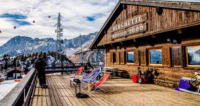
Località / Lage / Location: Loc. Olbe, Sappada (UD)
Gruppo / Berggruppe / Moutain Range: Gruppo Monti Lastroni
Mappa / Karte/ Map: Tabacco - Fg 01 Sappada, Santo Stefano, Forni Avoltri
Gestione / Betreiber / Management: Rifugi Srl
Proprietà / Besitz / Ownership: Comune di Sappada / Plodn
Periodi di apertura / Öffnung / Opening
Giugno e Settembre weekend. Luglio e Agosto tutti i giorni. Dal 28 dicembre al 6 gennaio
Wochenende im Juni und September. Juli und August jeden Tag. Winter: von 28 December bis 6 January Every weekend in June and September. And every day in July and August.
From the 28th of December to the 6th of January.
Percorsi in quota / Höhenwege / Mountain Trails
Laghi d’Olbe, Passo del Mulo
Principali ascensioni / Hauptaufstiege / Main Ascents
M. della Piana - M.Lastroni
Accesso
Raggiungibile utilizzando la comoda seggiovia di Sappada 2000 oppure con escursione di media difficoltà (2,5 h). Dal Rifugio Sappada 2000 si possono raggiungere con facile escursione i Laghi d’Olbe (1 h ca) o proseguire fino al Passo del Mulo e alla vetta del Monte Lastroni, dove sono presenti numerose testimonianze della Grande Guerra.
Wegbeschreibung
Bequem mit dem Sessellift Sappada 2000 oder mit einer mittelschweren Wanderung (2,5 Std.) zu erreichen. Vom Rifugio Sappada 2000 sind mit einer einfachen Wanderung (ca. 1 Std.) die Laghi d’Olbe zu erreichen, oder es geht weiter bis zum Passo del Mulo oder dem Gipfel des Monte Lastroni, wo es zahlreiche Zeugnisse des Ersten Weltkriegs gibt.
How to get there
The mountain hut can be reached via the comfortable Sappada 2000 chairlift or a medium-difficulty hike (2.5 hours). You can reach the Lakes of Olbe via an easy hike (approx. 1 hour) from the Sappada 2000 Mountain Hut or you can continue to the Mulo Pass and the summit of Mount Lastroni, where many traces of the First World War can still be seen.
m

Rifugio Sorgenti del Piave
Mobile: +39 334 7799175
e-mail: martinamichelaph@tiscali.it
Località / Lage / Location: Loc. Alta Val Sesis, Sappada (UD)
Gruppo / Berggruppe / Moutain Range: Gruppo Peralba-Chiadenis
Mappa / Karte/ Map: Tabacco - Fg 01 Sappada, Santo Stefano, Forni Avoltri
Gestione / Betreiber / Management: Famiglia Piller Hoffer
Proprietà / Besitz / Ownership: Famiglia Piller Hoffer
Periodi di apertura / Öffnung / Opening
Giugno - Settembre / Juni - September / June - September
Percorsi in quota / Höhenwege / Mountain Trails
Alta Via delle Dolomiti n° 6, percorso dei fortini delle Grande Guerra
Principali ascensioni / Hauptaufstiege / Main Ascents
M. Peralba, M. Chiadenis, M. Avanza, M. Lastroni
Accesso
Il Rifugio sorge nei pressi della polla da cui sgorga la sorgente del fiume Piave, dove nel 2015 è stata apposta la Fiamma della Pace. Accesso da Cima Sappada: per rotabile SP 22 della Val Sésis, (circa 8,5 km, 25 min. in auto); accesso dal Pian delle Bombarde, 1457 m, ore 1.30-1.45 T: per sentiero naturalistico, verso nord, al Passo del Roccolo, 1815 m, e poi a destra, in breve (s. 136) al rifugio; accesso dalla Val Visdende-Costa d’Antola, 1332 m, ore 2-2.15 T: per carrareccia e, al secondo bivio, per Giau rosso per carrareccia e sentiero (s. 133) al Passo del Roccolo, 1815 m, e poi a sx in breve (s. 136) al rifugio.
Wegbeschreibung
Wegbeschreibung von Cima Sappada: entlang der Straße SP 22 des Val Sésis, (circa 8,5 km, 25 min. mit dem Auto); ab Pian delle Bombarde, 1457 m, 1.30-1.45 Stunden T: über den Naturpfad, nach Norden, zum Passo del Roccolo, 1815 m und dann nach rechts, (s. 136) zur Hütte; vom Val Visdende-Costa d’Antola, 1332 m, 2-2.15 Stunden T: über den Karrenweg und an der zweiten Abzweigung, nach Giau rosso über den Karrenweg und den Weg (s. 133) zum Passo del Roccolo, 1815 m, und dann nach links (s. 136) zur Hütte.
How to get there
Arriving from Cima Sappada: Take the Val Sésis SP 22 by-road (approx. 8.5 km, 25 minutes by car). Arriving from Pian delle Bombarde (1457 m altitde, 1.5-1.75 hours, Tourist trail): head north along the nature trail to Passo del Roccolo (1815 m), then turn right onto Trail 136. You will reach the mountain hut shortly thereafter. Arriving from Val Visdende-Costa d’Antola (1332 m, 2-2.25 hours, Tourist trail): Take the cart track and at the second fork, head for Giau on the red cart track and Trail 133 up to Passo del Roccolo (1815 m). Turn left onto Trail 136 and you will reach the mountain hut shortly thereafter.

1.441 m
1
Rifugio Eimblatderibn
Mobile: +39 339 5723559
7 1
Località / Lage / Location: Loc. Eimblatderibn - Sauris (UD)
Gruppo / Berggruppe / Moutain Range: Alpi Carniche
Mappa / Karte/ Map: Tabacco - Fg 02 Forni di Sopra - Ampezzo - Sauris Alta Val Tagliamento
Gestione / Betreiber / Management: Diomiro Durighello
Proprietà / Besitz / Ownership:
Periodi di apertura / Öffnung / Opening
15 Giugno - 15 Settembre. Week end d’inverno
15. Juni - 15. September Wochenende im Winter
15 June - 15 September winter weekends
Percorsi in quota / Höhenwege / Mountain Trails
Giro delle malghe
Principali ascensioni / Hauptaufstiege / Main Ascents
Monti Pieltinis e Col Gentile
Accesso
Da Sauris di Sotto: lasciata l’auto nei pressi del Municipio, proseguire lungo la strada verso nord. Poco dopo la strada rotabile da asfaltata diventa sterrata e dopo alcuni saliscendi e un tratto sconnesso, si arriva al rifugio in 45 min.
Da Lateis: giunti in paese, lasciare l’auto al termine della strada asfaltata e proseguire lungo il sentiero CAI 220.
Wegbeschreibung
Ab Sauris di Sotto: das Auto in der Nähe des Rathauses abstellen und dann die Straße in Richtung Norden nehmen. Kurz darauf wird die asphaltierte Straße zu einer Schotterstraße und nach einigem Auf und Ab und einem unebenen Abschnitt erreicht man nach 45 Minuten die Berghütte.
Ab Lateis: im Dorf am Ende der asphaltierten Straße das Auto parken und weiter entlang des Wegs CAI 220.
How to get there
From Sauris di Sotto: leave your car near the Town Hall, then continue northwards along the road. Shortly afterwards, the paved road becomes a dirt road and after climbing and descending a number of times along an uneven path, the mountain hut can be reached in 45 minutes.
From Lateis: once in the village, leave your car at the end of the paved road and continue along the CAI 220 trail.
Rifugio Fornas
T +39 0433 565507 / Mobile (solo WhatsApp): +39 3881790521
e-mail: mail@rifugiofornas.com

Località / Lage / Location: Fornace n. 2 Tolmezzo (UD)
Gruppo / Berggruppe / Moutain Range: Prealpi Carniche
Mappa / Karte/ Map: Tabacco - Fg 026 Prealpi Carniche Val Tagliamento
Gestione / Betreiber / Management: Cappello Anna
Proprietà / Besitz / Ownership: Corradina Andrea
Periodi di apertura / Öffnung / Opening
Marzo - Dicembre / März - Dezember / March - December
Percorsi in quota / Höhenwege / Mountain Trails
M. Dauda / M. Zoncolan
Principali ascensioni / Hauptaufstiege / Main Ascents
M. Cuar / M. Dauda / M. Vas / M. Duron / M. Diverdalce
Accesso
Da Tolmezzo raggiungere la frazione di Fusea e proseguire verso Curiedi, dopo il campo sportivo seguire l’indicazione per Fornas e in 2 km si raggiunge in rifugio (raggiungibile anche in macchina,bici,moto,trekking).
Wegbeschreibung
Von Tolmezzo bis zum Ortsteil Fusea und weiter in Richtung Curiedi. Nach dem Sportplatz den Schildern nach Fornas folgen. Nach 2 km erreichen Sie die Berghütte (auch mit dem Auto, Fahrrad, Motorrad und per Trekking erreichbar)
How to get there
From Tolmezzo: reach the hamlet of Fusea and continue towards Curiedi. After the sports field, follow the signs for Fornas, and after 2 km, you reach the refuge (it can also be reached by car, bike, motorcycle, or trekking)

Passaggio tra Alpi e Prealpi Giulie
L’imponente profilo del Monte Canin domina lo spettacolare scenario delle Alpi Giulie - Riserva MaB UNESCO di Biosfera. Le sue suggestive caverne e grotte, tipiche dell’ambiente carsico, fanno del Canin un’area molto interessante per chi ama addentrarsi nei meravigliosi abissi alla scoperta delle bellezze scolpite dall’acqua nella roccia. Occasione imperdibile per avvicinarsi al magico ambiente delle Alpi Giulie è la salita al Monte Lussari, per raggiungere l’omonimo santuario attraverso itinerari immersi in una natura incontaminata e da dove lo sguardo abbraccia le cime di Italia, Austria e Slovenia. I numerosi rifugi della zona rappresentano ottime tappe lungo quella che si può definire la più bella traversata delle Alpi Giulie: l’Alta Via delle Alpi Tarvisiane. Le Prealpi Giulie, caratterizzate da versanti più dolci e meno scoscesi, sono luoghi magici che custodiscono tutt’oggi le tracce del passaggio di popoli d’altri tempi: numerosi ritrovamenti testimoniano infatti la presenza dell’uomo già in epoca preistorica.
Il Parco delle Prealpi Giulie è un paradiso di sentieri, da percorrere anche con guide esperte.
Il Lussari è anche il punto di incontro dei tre rami del Cammino Celeste, un itinerario religioso internazionale che collega tre luoghi simbolo della cristianità della Mitteleuropa: Aquileia, Brezje in Slovenia e Maria Saal in Austria.
Alpe-Adria-Trail, un itinerario a lunga percorrenza che collega tre Nazioni in 43 tappe complessive. Conduce dai piedi del monte più alto dell’Austria, il Großglockner, alle meravigliose coste della riviera triestina. Se non si ha il tempo o la preparazione per affrontare tutte le tappe, ma si desidera vivere l’emozione del trekking attraverso i tre confini, si può intraprendere il Giro delle 3 Nazioni: 123 km nelle Alpi e Prealpi Giulie da percorrere in 7 tappe giornaliere che costituiscono la variante breve dell’Alpe Adria Trail.
Den Alpen und Die Julischen Alpen
Das imposante Profil des Monte Canin dominiert die herrliche Szenerie der Julischen Alpen. Seine eindrucksvollen Höhlen und Grotten, typisch für die Karstlandschaft, machen aus dem Canin für denjenigen, der es liebt, in die herrlichen Tiefen auf der Suche nach den vom Wasser in die Felsen geschnittenen Schönheiten vorzudringen, ein ausgesprochen interessantes Gebiet. Eine nicht zu verpassende Gelegenheit, um sich der zauberhaften Landschaft der Julischen Alpen zu nähern, ist der Anstieg zum Monte Lussari, um dort die gleichnamige Wallfahrtskirche über Strecken inmitten der unberührten Natur zu erreichen und von wo aus der Blick die Gipfel Italiens, Österreichs und Sloweniens umarmt. Die zahlreichen Berghütten der Region stellen hervorragende Etappen dar, entlang derer man die schönste Überquerung des Julischen Alpen aufzeigen kann: der Höhenweg Alta Via delle Alpi Tarvisiane.
Die Julischen Voralpen werden von sanfteren und weniger steilen Hängen gekennzeichnet, sie sind
zauberhafte Orte, die bis heute die Spuren des Durchqueren der damaligen Völker bewahren: zahlreiche Funde bezeugen das Vorkommen des Menschen bereits in der Frühgeschichte. Der Parco delle Prealpi Giulie ist ein Paradies an Pfaden, die auch mit professionellen Guides zurückgelegt werden können. Der Lussari ist auch ein Treffpunkt der drei Zweige des Cammino Celeste, eine internationale religiöse Strecke, die drei symbolträchtige Orte des Christentums in Mitteleuropa verbindet. Alpe-Adria-Trail, eine lange Strecke, die drei Nationen in insgesamt 43 Etappen verbindet. Sie führt vom höchsten Berg Österreichs, dem Großglockner, zu den herrlichen Küsten der Riviera Triestina. Wenn man nicht die Zeit oder das Vermögen hat, um alle Etappen zu bewältigen, jedoch die Emotionen des Trekkings über die drei Grenzen erleben möchte, so kann der Rundweg der 3 Nationen eingeschlagen werden: 123 km in 7 Tagesstrecken, die eine kurze Variante des Alpe Adria Trails darstellen.
Passing through the Julian Alps and Prealps
The imposing profile of the Monte Canin dominates the spectacular scenery of the Julian Alps. Its fascinating caverns and caves, which are typical of the Karst landscape, make Canin a very interesting area for those who love to venture into wonderful abysses in order to discover beautiful rocks that have been sculpted by the water. An unmissable opportunity where you can delve into the magical world of the Julian Alps is the climb to the top of Monte Lussari to reach the homonymous sanctuary. This is reached via routes immersed in unspoiled nature and where you can even see the mountain peaks in Italy, Austria and Slovenia. The area’s numerous mountain huts are great resting places along what is said to be one of the most beautiful traverses of the Julian Alps: Alta Via delle Alpi Tarvisiane.
The Julian Prealps with their gentler and less steep slopes, are magical places that still
preserve the tracks that people in ancient times used to cross: in fact, many discoveries have pointed to the fact that humans had already settled here in prehistoric times. The Julian Prealps Park is a paradise of hiking trails, that can also be travelled with experienced guides. The Lussari is also the meeting point of the three branches of “The Heavenly Way” pilgrimage, an international religious route that links three symbolic Central European Christian sites.
Alpe-Adria-Trail, a long-distance route that links three nations with 43 stages in total. It leads from the foot of the highest mountain in Austria, the Grossglockner, to the coastline of the Trieste Riviera. If you would like to experience the excitement of hiking through the three borders, you can undertake the Giro delle 3 Nazioni: 123 km which includes 7 stages per day, the short version of the Alpe-Adria-Trail.
1.874 m
Temporaneamentechiuso Vorübergehendgeschlossen
Temporarilyclosed
Rifugio Guido Corsi
Chiuso / Geschlossen / Closed

Località / Lage / Location: Cave dal Predil (UD)
Gruppo / Berggruppe / Moutain Range: Gruppo Jof Fuart
Mappa / Karte/ Map: Tabacco - Fg 019 Alpi Giulie Occidentali Tarvisiano
Gestione / Betreiber / Management:
Proprietà / Besitz / Ownership: Società Alpina delle Giulie, Sezione CAI di Trieste
Periodi di apertura / Öffnung / Opening
Chiuso / Geschlossen / Closed
Percorsi in quota / Höhenwege / Mountain Trails
Alta via Alpi Tarvisiane, sentiero attrezzato Anita Goitan e Ceria-Merlone, sentiero Re di Sassonia
Principali ascensioni / Hauptaufstiege / Main Ascents
Jof Fuart
Accesso
Dalla Valle Rio del Lago: percorrere la strada forestale che conduce alle malghe Grantagar; proseguire lungo i sentieri CAI 628 e 625 passando sotto la Parete delle Gocce. Si giunge al rifugio in 2 ore e 30 complessive.
Da Sella Nevea: percorrere il sentiero CAI 625 a malga Cregnedul di Sopra e dal Passo degli Scalini, si giunge al rifugio in circa 2 ore e 45 totali.
Wegbeschreibung
Vom Valle Rio del Lago: die Forststraße entlang, die zu den Almen von Grantagar führen, weiter entlang der Wege CAI 628 und 625 unter der Parete delle Gocce durch. In rund 2 ½ Stunden erreicht man die Berghütte.
Ab Sella Nevea: den Weg CAI 625 bis zu Alm Cregnedul di Sopra folgen und dann ab dem Passo degli Scalini kann die Berghütte in etwa 2 Stunden und 45 Minuten erreicht werden.
How to get there
From the Valle Rio del Lago: Take the forest road which leads to the Grantagar alpine pastures; continue along the CAI 628 and 625 trails, passing underneath the Parete delle Gocce. You will reach the mountain hut in a total of 2.5 hours.
From Sella Nevea: Take the CAI 625 trail to the Cregnedul di Sopra alpine pasture and Scalini Pass. You will reach the mountain hut in a total of 2.75 hours.
1.660 m

Rifugio Giacomo Di Brazzà
Mobile: +39 346 2280072
e-mail: valentinacecon@gmail.com 1
Località / Lage / Location: Sella Nevea, Chiusaforte (UD)
Gruppo / Berggruppe / Moutain Range: Montasio Plateaus
Mappa / Karte/ Map: Tabacco - Fg 027-019 Canin-Val Resia-Parco Nat.Prealpi Giulie/Alpi Giulie
Occidentali-Tarvisiano
Gestione / Betreiber / Management: Valentina Cecon
Proprietà / Besitz / Ownership: SAF - Sezione CAI di Udine
Periodi di apertura / Öffnung / Opening
Giugno - Settembre. Ottobre nei fine settimana. Eventuale apertura invernale / Juni - September. Oktober an den Wochenenden und eventual Winteröffnung / June - September. Weekends in October and eventual winter opening
Percorsi in quota / Höhenwege / Mountain Trails
Alta via delle Alpi Tarvisiane, sentiero attrezzato Anita Goitan, sentiero attrezzato Leva, sentiero attrezzato Ceria Merlone
Principali ascensioni / Hauptaufstiege / Main Ascents
Jof di Montasio, Cimone del Montasio, Cima di Terra Rossa, Bivacco Vuerich sul Foronon del Buinz
Accesso
Da Sella Nevea si imbocca la rotabile che porta all’altopiano del Montasio. Al termine della strada (m 1502), si segue il sentiero CAI 622 ed in circa mezz’ora si raggiunge il rifugio.
Wegbeschreibung
Ab Sella Nevea biegt man in die Straße ein, die zur Hochebene des Montasio führt. Am Ende der Straße (1502 m), folgt man der Wegmarke CAI 622 und erreicht nach zirka einer halben Stunde die Berghütte.
How to get there
Take the road from Sella Nevea that leads to the Montasio Plateau. At the end of the road (1502 m), follow the CAI 622 trail and in approximately half an hour, you will reach the mountain hut.
Temporaneamentechiuso Vorübergehendgeschlossen Temporarilyclosed
Rifugio Divisione Julia
Chiuso / Geschlossen / Closed

Località / Lage / Location: Chiusaforte (UD)
Gruppo / Berggruppe / Moutain Range: Sella Nevea Chiusaforte
Mappa / Karte/ Map: Tabacco - Fg 019 - 027
Canin - Val Resia, Parco Nat.Prealpi Giulie/ Alpi Giulie
Accesso
Occidentali-Tarvisiano
Gestione / Betreiber / Management: Associazione allevatori del FVG
Proprietà / Besitz / Ownership: SAF - CAI Udine
Periodi di apertura / Öffnung / Opening
Aperto tutto l’anno tranne il mese di novembre.
Ganzjährig geöffnet, außer im November. Open all year round except November.
Percorsi in quota / Höhenwege / Mountain Trails
Alta Via Resiana, Traversata delle Alpi Giulie
Principali ascensioni / Hauptaufstiege / Main Ascents
Cime dei Gruppi del Montasio e del Canin
Il rifugio si trova nell’abitato di Sella Nevea, raggiungibile da Chiusaforte attraverso la SP76 Val Raccolana in circa 15 km o da Tarvisio attraverso la SS54 e la SP76 passando per Cave del Predil in 22 km.
Wegbeschreibung
Die Berhütte befindet sich in der Siedlung der Sella Nevea und ist ab Chiusaforte über die SP76 Val Raccolana in circa 15 km oder ab Tarvsio über die SS54 und die SP76, vorbei an Cave del Predil, 22 km erreichbar.
How to get there
Located in the village of Sella Nevea. It can be reached from Chiusaforte via the SP76 Val Raccolana B-road in approximately 15 km or from Tarvisio, via the SS54 and the SP76 road, which pass after 20 km through Cave del Predil.
1.660 m

Rifugio Celso Gilberti
T: +39 0433 54015 / Mobile: +39 333 8192055
e-mail: iri.piri@virgilio.it
Località / Lage / Location: Sella Nevea, Chiusaforte (UD)
Gruppo / Berggruppe / Moutain Range: Gruppo del Canin
Mappa / Karte/ Map: Tabacco - Fg 019 Alpi Giulie Occidentali Tarvisiano
Gestione / Betreiber / Management: Irene Pittino
Proprietà / Besitz / Ownership: SAF - Sezione di Udine del CAI
Periodi di apertura / Öffnung / Opening
Dicembre - Aprile. Giugno - Settembre / Dezember - April. Juni - September December - April. June - September
Percorsi in quota / Höhenwege / Mountain Trails
Sentiero Storico del Canin, Alta Via Resiana, Sentiero Botanico, Mulattiera della Grande Guerra sentiero CAI 636
Principali ascensioni / Hauptaufstiege / Main Ascents
Monte Canin, Monte Forato, Monte Robon, Monte Sart
Accesso
Il Rifugio dista 2 minuti dalla stazione a monte della Telecabina che sale da Sella Nevea. Può essere raggiunto senza difficoltà a piedi in 1.45 circa di cammino percorrendo il sentiero CAI che parte dalla nuova cabinovia a Sella Nevea e sbuca sotto le pareti del Bila Pec.
Il Rifugio si trova al centro del “Vallon di Prevala”, fra l’omonima Sella e la Sella Bila Pec, nel gruppo del Monte Canin.
Wegbeschreibung
Die Berghütte liegt 2 Minuten vom Bahnhof entfernt, vor der Seilbahn, die zum Sella Nevea hinauffährt. Über den Weg CAI 635 ab Sella Nevea kann sie zu Fuß in zwei Stunden erreicht werden. Die Berghütte befindet sich im Zentrum des „Vallon di Prevala”, zwischen dem gleichnamigen Sella Prevala und dem Sella Bila Pec, in der Berggruppe des Monte Canin.
How to get there
The mountain hut is 2 minutes from the cable car station that ascends from Sella Nevea. It takes 2 hours to reach the hut on foot via the CAI 635 trail which starts from Sella Nevea. The mountain hut is located in the centre of the “Vallon di Prevala”, between the homonymous Sella and Sella Bila Pec, in the Monte Canin mountain range.
1.170 m

Temporaneamentechiuso Vorübergehendgeschlossen Temporarilyclosed
Rifugio Ignazio Piussi
Chiuso / Geschlossen / Closed 1
Località / Lage / Location: Sot Cregnedul, Sella Nevea, Chiusaforte (UD)
Gruppo / Berggruppe / Moutain Range: Sella Nevea, Chiusaforte
Mappa / Karte/ Map: Tabacco - Fg 019 Alpi Giulie Occidentali Tarvisiano
Gestione / Betreiber / Management: Anna Piussi / Giuseppe Saccavino
Proprietà / Besitz / Ownership: Comune di Chiusaforte
Periodi di apertura / Öffnung / Opening
Chiuso / Geschlossen / Closed
Percorsi in quota / Höhenwege / Mountain Trails
Trekking Anello delle Alpi Giulie, Traversata Gruppo del Montasio, Alta Via Resiana
Principali ascensioni / Hauptaufstiege / Main Ascents
Jôf di Montasio, Jôf Fuart, Monte Canin, Monte Forato.
Arrampicata libera: Palestra del Nut, Palestra del Bila Pec
Accesso
Da Tarvisio verso Sella Nevea, 2 km prima dell’abitato ben individuabile sulla destra.
Da Sella Nevea, circa 2 km dopo l’abitato, dopo il primo tornante presso il ristorante - parcheggio visibile.
Servizi Prima colazione, pranzo o cena nell’attiguo ristorante “La Malga del Piussi” Il rifugio è nella stessa struttura del polo espositivo “La malga dell’Alpinismo” (ingresso gratuito).
Wegbeschreibung
Ab Tarvisio in Richtung Sella Nevea, 2 km vor der gut zu erkennenden Siedlung rechts.
Ab Sella Nevea etwa 2 km nach die Ortschaft, nach der ersten Kehre, am sichtbaren Restaurant-Parkplatz. Leistungen Frühstück, Mittag- oder Abendessen im angrenzenden Restaurant „La Malga del Piussi” Die Berghütte befindet sich in der gleichen Einrichtung des Ausstellungszentrums “La malga dell’Alpinismo” (Eintritt frei).
How to get there
From Tarvisio: head towards Sella Nevea, it is 2 km before the wellsignposted town on the right.
From Sella Nevea: approximately 2 km after the village, the mountain hut is located after the first hairpin bend, at the restaurant with the visible car park.
Services Breakfast, lunch or dinner in the adjacent “La Malga di Piussi” restaurant. The mountain hut is in the same building as the “La malga dell’Alpinismo” (The mountaineering alpine pasture) exhibition centre (free admission).

T: +39 0428 871860 / Mobile: +39 3337999272
e-mail: info@rifugiokugy.com
31 Rifugio Casa Alpina Julius Kugy
Località / Lage / Location: Malborghetto Valbruna (UD)
Gruppo / Berggruppe / Moutain Range:
Mappa / Karte/ Map: Tabacco - Fg 019 Alpi Giulie Occidentali Tarvisiano
7
Gestione / Betreiber / Management: Barbara Perdan
Proprietà / Besitz / Ownership: Sezione CAI XXX Ottobre - Trieste
Periodi di apertura / Öffnung / Opening
Giugno - metà Settembre; Dicembre - Marzo
Juni - Mitte September; Dezember-März / June - mid-September; December-March
Percorsi in quota / Höhenwege / Mountain Trails
Rifugio Grego, Cima Sompdogna, Lussari dalla strada forestale o dalla Limerza, Penultima tappa del Cammino Celeste, Tappa Sentiero Italia, Cengia degli Dei, Sella Prasnig
Principali ascensioni / Hauptaufstiege / Main Ascents
Jof Fuart, Jof di Montasio, Cima Nabois, Jof di Miezegnot, Monte Lussari
Accesso
Il rifugio si trova nel centro del paese di Valbruna, raggiungibile dall’Autostrada A23, uscita Ugovizza-Valbruna. Proseguire a sinistra in direzione Valbruna per 1,5 km e, dopo le prime case, si arriva alla Casa Alpina Rifugio Kugy. Servizi Visita al parco tematico della grande guerra, visita al parco “Altre memorie” opere permanenti di artisti ambientali, visita a “forte Beisner”, sala multimediale per proiezioni, ricovero bici gratuito, accesso per disabili.
Wegbeschreibung
Die Berghütte befindet sich in der Ortschaft Valbruna und ist über die Autibahn A23, Ausfahrt UgovizzaValbruna, erreichbar. Weiter nach links, für 1,5 km in Richtung Valbruna und nach den ersten Häusern erreicht man die Casa Alpina. Leistungen Besuch des Themenparks des Erster Weltkriegs, Besuch des Parks „Altre memorie“ mit einer Dauerausstellung von Künstlern aus der Umgebung, Besichtigung des Bunkers „Forte Beisner“, Multimedia-Saal für Vorführungen, kostenlose Fahrradunterbringung.
How to get there
The mountain hut is located in the village of Valbruna, and can be reached from the Ugovizza-Valbruna exit of the A23 motorway. Continue left towards Valbruna for 1.5 km and, after the first few houses, you will arrive at the Casa Alpina. Services Visit to the Great War theme park, visit to the “Beisner fort” park with permanent works of art from environmental artists, visit to the “Beisner fort”, projectorcompatible multimedia room, free bike shelter.
RIFUGIO IN BIBLIOTECA

Rifugio Fratelli Grego
Mobile: +39 349 1997876
e-mail: renatoben53@gmail.com
Località / Lage / Location: Malborghetto Valbruna (UD)
Gruppo / Berggruppe / Moutain Range: Gruppo Jof di Montasio, Jof Fuart
Mappa / Karte/ Map: Tabacco - Fg 019 Alpi Giulie Occidentali, Tarvisiano
Gestione / Betreiber / Management: Renato Ben
Proprietà / Besitz / Ownership: Società Alpina Giulie Sezione CAI di Trieste
Periodi di apertura / Öffnung / Opening
Giugno - Settembre / Juni - September / June - September
Percorsi in quota / Höhenwege / Mountain Trails
Alta Via Alpi Tarvisiane
Principali ascensioni / Hauptaufstiege / Main Ascents Montasio, Jof di Somdogna, Jof di Miezegot
Accesso
Da Dogna: lungo la strada asfaltata della valle omonima, si raggiunge, dopo 18 km, Sella di Sompdogna. Quindi per carrareccia, in 10 minuti di cammino, si raggiunge il rifugio. Da Valbruna: percorrere la strada della Val Saisera fino alla radura di Malga Saisera. Da qui si prosegue a piedi, prima per pista forestale, poi per mulattiera (segnavia CAI 611) e in un’ora di cammino e 400 m di salita entro un ricco bosco di faggio e abete bianco e abete rosso, si raggiunge il rifugio.
Wegbeschreibung
Ab Dogna, entlang der asphaltierten Straße des gleichnamigen Tals, erreicht man nach 18 km Sella di Sompdogna. Dann erreicht man nach 10 Minuten der Wanderung über den Karrenweg die Berghütte. Ab Valbruna: der Straße des Val Saisera bis zur Lichtung der Saisera Alm folgen. Von hier weiter zu Fuß, zuerst über einen Waldweg, dann über den Maultierpfad (Wegmarke 611) und nach einer Stunde der Wanderung und 400 m Anstieg, erreicht man in einem dichten Wald aus Buchen und Weiß- und Rottannen die Berghütte.
How to get there
From Dogna: Travel along the paved road of the homonymous valley and after 18 km you will reach Sella di Sompdogna. After a 10-minute walk along the track, you will reach the mountain hut.
From Valbruna: Take the road that leads to the Val Saisera, until you reach the clearing of the Saisera alpine pasture. From here, continue on foot along the forest road which then becomes a mule track (signposted CAI 611) and after an hours’ walk and 400 vertical metres in a forest flourishing with beech, silver fir and Norway spruce trees, you will reach the mountain hut.

Località / Lage / Location: Tarvisio (UD)
Gruppo / Berggruppe / Moutain Range: Gruppo Jof Fuart, Alla Carnizza di Camporosso
Mappa / Karte/ Map: Tabacco - Fg 019 Alpi Giulie Occidentali Tarvisiano
Gestione / Betreiber / Management: Giorgio Da Rin Puppel-Gadetta / Sara Ursella
Proprietà / Besitz / Ownership: Società Alpina delle Giulie Sezione CAI Trieste
Periodi di apertura / Öffnung / Opening
Giugno - Settembre / Juni - September / June - September
Percorsi in quota / Höhenwege / Mountain Trails
Sentiero Chersi, Sentiero Cavalieri, Alta Via delle Alpi Tarvisiane, Anello delle Rondini”
Principali ascensioni / Hauptaufstiege / Main Ascents
Gola NE allo Jof Fuart, Cresta Est e Via Normale al Nabois, Cengia dei Camosci al Nabois, Cengia degli Dei, Via Comici alla Riofreddo
Accesso
Da Valbruna si prosegue per circa 2,5 km lungo la rotabile della Val Saisera fino al pargheggio P2. Una stradina chiusa al transito attraversa il Torrente Saisera, mulattiera fino alla stazione di valle della teleferica e diventa ripido sentiero sotto le pareti di roccia. Lasciata a sinistra la diramazione per Sella Prasnig, si guadagna una costola rocciosa e traversate alcune lingue ghiaiose, dopo gli ultimi tornanti, con alcune sorgenti, in breve tempo si raggiunge il rifugio (sentiero CAI 616, ore 2.00).
Wegbeschreibung
Von Valbruna folgt man für zirka 2,5 km der befahrbaren Straße des Val Saisera bis zum Parkplatz P2. Eine für den Verkehr geschlossene Straße überquert den Wildbach Saisera, Maultierpfad bis zur Talstation der Schwebebahn und wird zu einem steilen Pfad unterhalb der Felswände. Lässt man die Abzweigung nach Sella Prasnig links, überwindet man einen steinigen Gebirgsausläufer und nach der Überquerung einiger kiesiger Streifen, nach den letzten Kehren mit einigen Quellen, erreicht man kurz darauf die Berghütte (Pfad CAI 616, 2.00 Stunden).
How to get there
From Valbruna: Travel for around 2.5 km along the Val Saisera road until you reach the P2 car park. A road that is closed to vehicles crosses the Saisera Stream. Follow the mule track up to the cable car station and the path then becomes steeper, beneath the rock walls. Take a left at the fork for Sella Prasnig and the path will become rocky and there will become rocky with some gravelly slides hairpin bends and a few springs, you will shortly reach the mountain hut (CAI 616 trail, 2 hours).

Rifugio Locanda al Convento
Mobile: +39 338 1781133
e-mail: info@rifugioalconvento.it / www.rifugioalconvento.it
Località / Lage / Location: Loc. Monte Lussari, Tarvisio (UD)
Gruppo / Berggruppe / Moutain Range: Gruppo Jof Fuart, Monte Santo di Lussari
Mappa / Karte/ Map: Tabacco - Fg 019 Alpi Giulie Occidentali Tarvisiano
Gestione / Betreiber / Management: Giorgio Preschern
Proprietà / Besitz / Ownership: Parrocchia di S. Egidio Via Valcanale, 79 - Camporosso
Periodi di apertura / Öffnung / Opening
In base all’apertura della telecabina.
Je nach Öffnung der Seilbahn / Depending on the opening of the cable car.
Percorsi in quota / Höhenwege / Mountain Trails
Cammino Celeste, Alpe Adria Trail
Principali ascensioni / Hauptaufstiege / Main Ascents
Cima del Cacciatore
Accesso
Da Camporosso: con Telecabina del Monte Lussari (info c/o Tarvisio Infopoint +39 0428 2135) in 15 minuti.
Da Valbruna: percorrere la strada della Val Saisera fino all’imbocco del sentiero CAI 615 e proseguire poi sul 616 e strada forestale (2 ore).
Da Camporosso: sentiero “del Pellegrino” CAI 613 (circa 2 ore di cammino).
Il Rifugio fa parte del piccolo nucleo di edifici situati attorno al Santuario Mariano di Lussari.
Wegbeschreibung
Von Camporosso mit der Seilbahn des Monte Lussari (Info +39 0428 2135) in 15 Minuten.
Ab Valbruna: der Straße des Val Saisera bis zur Einmündung in den Wanderweg CAI 615 folgen, dann weiter auf dem 616 und der Forststraße (2 Stunden).
Ab Camporosso: dem Wanderweg „del Pellegrino” CAI 613 folgen (circa 2 Stunden Wanderzeit). Die Berghütte ist Teil des kleinen Gebäudekerns, der die Wallfahrtskirche Mariano i Lussari umgibt.
How to get there
From Camporosso: Via the Monte Lussari cable cars (for timetable information, call the Tarvisio Infopoint on +39 0428 2135) that takes 15 minutes.
From Valbruna: Take the road that leads to the Val Saisera, until you reach the start of the CAI 615 trail and then continue on the CAI 616 and forest road (2 hours).
From Camporosso: Along the CAI 613 “del Pellegrino” trail (approximately a 2 hours’ walk). The mountain hut is part of a small group of buildings located around the Sanctuary of Mariano Lussari.

Rifugio Monte Lussari Fam. Meschnik
T: +39 0428 63242 / Mobile: +39 331 6813180
e-mail: rifugioalpinomontelussari1@gmail.com / www.rifugioalpinomontelussari.it
Località / Lage / Location: Loc. Monte Lussari, Tarvisio (UD)
Gruppo / Berggruppe / Moutain Range: Gruppo Jof Fuart, Monte Santo di Lussari
Mappa / Karte/ Map: Tabacco - Fg 019 Alpi Giulie Occidentali Tarvisiano
Gestione / Betreiber / Management: Michele Meschnik
Proprietà / Besitz / Ownership: Michele Meschnik
Periodi di apertura / Öffnung / Opening
In base all’apertura della telecabina.
Je nach Öffnung der Seilbahn / Depending on the opening of the cable car.
Percorsi in quota / Höhenwege / Mountain Trails
Cammino Celeste, Alpe Adria Trail
Principali ascensioni / Hauptaufstiege / Main Ascents
Cima del Cacciatore
Accesso
Da Camporosso: con Telecabina del Monte Lussari (info c/o Tarvisio Infopoint +39 0428 2135) in 15 minuti.
Da Valbruna: percorrere la strada della Val Saisera fino all’imbocco del sentiero CAI 615 e proseguire poi sul 616 e strada forestale (2 ore).
Da Camporosso: sentiero “del Pellegrino” CAI 613 (circa 2 ore di cammino).
Il Rifugio fa parte del piccolo nucleo di edifici situati attorno al Santuario Mariano di Lussari.
Wegbeschreibung
Von Camporosso mit der Seilbahn des Monte Lussari (Info +39 0428 2135) in 15 Minuten.
Ab Valbruna: der Straße des Val Saisera bis zur Einmündung in den Wanderweg CAI 615 folgen, dann weiter auf dem 616 und der Forststraße (2 Stunden).
Ab Camporosso: dem Wanderweg „del Pellegrino” CAI 613 folgen (circa 2 Stunden Wanderzeit). Die Berghütte ist Teil des kleinen Gebäudekerns, der die Wallfahrtskirche Mariano i Lussari umgibt.
How to get there
From Camporosso: Via the Monte Lussari cable cars (for timetable information, call the Tarvisio Infopoint on +39 0428 2135) that takes 15 minutes.
From Valbruna: Take the road that leads to the Val Saisera, until you reach the start of the CAI 615 trail and then continue on the CAI 616 and forest road (2 hours).
From Camporosso: Along the CAI 613 “del Pellegrino” trail (approximately a 2 hours’ walk). The mountain hut is part of a small group of buildings located around the Sanctuary of Mariano Lussari.

1.380 m
2
Mobile: +39 333 3080555
e-mail: info@rifugiozacchi.com / www.rifugiozacchi.com
Località / Lage / Location: Loc. Conca delle Ponze, Fusine di Tarvisio(UD)
Gruppo / Berggruppe / Moutain Range: Gruppo Ponze, alla Conca delle Ponze
Mappa / Karte/ Map: Tabacco - Fg 019 Alpi Giulie Occidentali Tarvisiano
Gestione / Betreiber / Management: Eremo Srl
Proprietà / Besitz / Ownership: Regione Friuli Venezia Giulia
Periodi di apertura / Öffnung / Opening
Dicembre - Aprile. Giugno - Settembre / Dezember - April. Juni - September
December - April. June - September
Percorsi in quota / Höhenwege / Mountain Trails
Alta Via Tarvisiana, Via della Vita, Alpe Adria Trail
Principali ascensioni / Hauptaufstiege / Main Ascents
Porticina, Ponza Grande, Veunza, Mangart
Accesso
Superato il paese di Fusine, si devia a destra verso i laghi, nel cuore della Foresta di Tarvisio. Dal lago superiore si segue il segnavia CAI 512, che prima in piano e poi con pendenza marcata, porta al rifugio in circa 1,30 ore.
Wegbeschreibung
Nach der Ortschaft Fusine biegt man nach rechts in Richtung der Seen ein, in das Herz des Waldes von Tarvisio. Vom oberen See folgt man dem Weg CAI 512, der zunächst flach und dann steil ansteigend zur Berghütte führt; Wegdauer etwa 1,5 Stunden.
How to get there
Once you have passed the village of Fusine, turn right towards the lakes, into the heart of the Tarvisio Forest.
Follow the CAI 512 signposted trail from the upper lake, which is level at first and then begins to rise sharply. It leads to the mountain hut in roughly 1.5 hours.
Rifugio Pian dei Ciclamini
Mobile: +39 348 7690918
e-mail: info@rifugiopiandeiciclamini.it
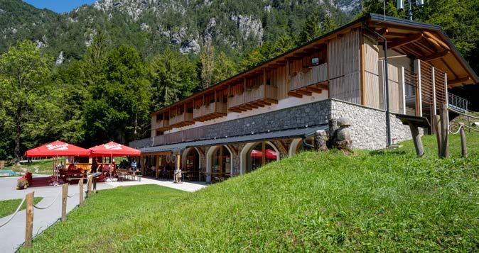
Località / Lage / Location: Loc. Pian dei Ciclamini, Lusevera (UD)
Gruppo / Berggruppe / Moutain Range: Monti Musi
Mappa / Karte/ Map: Tabacco - Fg 026 Prealpi Giulie Valli del Torre
Gestione / Betreiber / Management: Simone Gonano
Proprietà / Besitz / Ownership: Parco Naturale delle Prealpi Giulie
Periodi di apertura / Öffnung / Opening
Sempre aperto giugno - settembre. Aprile, maggio e ottobre aperti nei weekend e giorni festivi. Immer geöffnet Juni - September. April, Mai und Oktober an Wochenenden und Feiertagen geöffnet. Always open June - September. April, May and October open on weekends and public holidays.
Percorsi in quota / Höhenwege / Mountain Trails
Cammino Celeste, Sentiero Naturale valle Musi, Passo Tanamea, Via Alpina
Principali ascensioni / Hauptaufstiege / Main Ascents
Ferrata CAI 757 da Bivacco Brollo a Cresta del Monte Musi
Accesso
In auto, moto e bici: da Tarcento (UD) prendere la strada verso Alta Val Torre direzione Uccea, superare Pradieliis e Musi. Il rifugio si trova lungo la statale SR646 sulla sinistra, poco prima del Passo Tanamea direzione Bovec (SLO). Da Resia prendere SR646 direzione Uccea e poi continuare lungo SR646 direzione Italia. Verificare l’apertura della strada prima di avventurarsi.
Wegbeschreibung
Mit dem Auto, Motorrad, Fahrrad: Von Tarcento (UD) nehmen Sie die Straße in Richtung Alta Val Torre in Richtung Uccea, vorbei an Pradieliis und Musi. Die Schutzhütte befindet sich entlang der SR646 State Road auf der linken Seite, kurz vor dem Tanamea Pass in Richtung Bovec (SLO).
Von Resien nehmen Sie die SR646 Richtung Uccea und fahren dann weiter auf der SR646 in Richtung Italien. Überprüfen Sie die Öffnung der Straße, bevor Sie sich auf den Weg machen.
How to get there
By car, motorcycle or bike: from Tarcento (UD) take the road towards Alta Val Torre and Uccea, pass Pradieliis and Musi. The refuge is located along the SR646 state road on the left, just before the Tanamea Pass towards Bovec (SLO). From Resia take SR646 direction Uccea and then continue along SR646 direction Italy. Check the opening of the road before venturing.

Valli inaspettate
Le escursioni in questa parte delle Prealpi Giulie sono una esperienza unica tra natura e storia. Punto di incontro tra le culture friulana e slovena, le Valli sono sempre state storicamente una zona di confine, dall’epoca dei Romani fino al XX secolo, con il fronte della Grande Guerra e la linea della cortina di ferro, come si può ancora vedere sull’Altopiano del Kolovrat. Oggi però, con la caduta dei confini e la fine delle numerose servitù militari, si può godere di questo paesaggio sorprendente dove il tempo sembra essersi fermato. La selvaggia bellezza e l’autenticità di questi luoghi attirano persone ed esperienze diverse e apparentemente distanti.
Nelle Valli si incontrano l’antico Santuario della Madonna di Castelmonte ma anche il centro buddista di Polava, il centro naturalistico del Villaggio degli Orsi di Pulfero e i musicisti che frequentano il piccolo borgo di Topolò, sede di un festival internazionale dedicato alle avanguardie artistiche.
Le Valli sono attraversate da due percorsi molto significativi: l’Alpe Adria Trail, che collega una serie di sentieri cartografati e dotati di servizi informativi e di accoglienza, e il Cammino Celeste, un itinerario che collega Aquileia al Lussari, entrambi luoghi simbolici della religiosità in Friuli Venezia Giulia.
Il sentiero transfrontaliero Pot Miru ripercorre il fronte della Grande Guerra e conduce alla scoperta delle testimonianze più rilevanti, resti e monumenti commemorativi del fronte dell’Alto Isonzo.

Unerwartete Täler
Die Ausflüge in diesen Teil der Julischen Voralpen sind eine einzigartige Erfahrung zwischen Natur und Geschichte. Als Kreuzungspunkt der friaulischen und slowenischen Kultur, waren die Täler historisch gesehen, seit der Römerzeit bis zum XX. Jh., von je her ein Grenzgebiet, mit der Front des Erster Weltkriegs und der Linie des Eisernen Vorhangs, wie noch heute auf der Hochebene des Kolovrat zu sehen ist. Heute jedoch, mit dem Fall der Grenzen und dem Ende der zahlreichen Militärdienstbarkeiten kann man diesen überraschenden Landstrich genießen, wo die Zeit stehengeblieben zu sein scheint. Die wilde Schönheit und die Authentizität dieser Orte ziehen Menschen mit unterschiedlichen und scheinbar gegensätzlichen Erfahrungen an.
In den Tälern trifft man auf die antike Wallfahrtskirche Santuario della Madonna di Castelmonte, aber auch auf das buddhisti-
Unexpected valleys
The routes in this part of the Julian Prealps, have a unique blend of nature and history. A meeting point between the Friulian and Slovenian cultures, the Valleys have historically always been a border area, since the time of Romans, right up to the 20th century with the front of the Great War and the line of the Iron Curtain which can still be seen on the Kolovrat Plateau. Today, however, the borders have fallen and the easement for military purposes has ended, so you can enjoy this amazing landscape where time seems to have stood still. The wild beauty and authenticity of these places attract different people with varying degrees of experience from all over the world.
In the Valleys, there is the ancient sanctuary of Madonna di Castelmonte, in addition to the Buddhist Centre of Polava, the Villaggio
sche Zentrum von Polava, das Naturzentrum, wie das Bärendorf Villaggio degli Orsi in Pulfero, sowie die Musiker, die das kleine Dorf Topolò aufsuchen, Standort eines internationalen Festivals der künstlerischen Avantgarde. Die Täler werden von zwei bedeutenden Routen durchquert: dem Alpe Adria Trail, der eine Reihe von kartierten Wegen verbindet, die mit Informations- und Gästebetreuungseinrichtungen ausgestattet sind, sowie der Cammino Celeste, eine Strecke, die Aquileia mit Lussari verbindet, beides symbolträchtige Orte der Religiosität im Friaul-Julisch Venetien.
Der grenzüberschreitende Wanderweg Pot Miru verläuft entlang der Front des Erster Weltkriegs und führt zur Entdeckung der bedeutendsten Zeitzeugnisse, Überreste und Gedächtnisstätten der Front des Alto Isonzo.
degli Orsi nature conservation centre in Pulfero and the musicians who haunt the small village of Topolò, the home of an international festival devoted to artistic avant garde. Two very significant trails cross the Valleys: the Alpe-AdriaTrail, which connects a series of mapped trails that are equipped with information services and accommodation, and the The Heavenly Way, a route that connects Aquileia to Lussari, two symbolic religious places in Friuli Venezia Giulia.
The Pot Miru cross-border trail, retraces the Front of the Great War and leads to the discovery of some of the most important testimonies, remnants and commemorative monuments of the Alto Isonzo Front.
Rifugio Casoni Solarie
Mobile: +39 3394135134
e-mail: rifugiosolarie@gmail.com

Località / Lage / Location: Drenchia (UD)
Gruppo / Berggruppe / Moutain Range: Colovrat - Matajur
Mappa / Karte/ Map: Tabacco - Fg 041 Valli del Natisone Cividale del Friuli
Gestione / Betreiber / Management: Nicola Mezzogori
Proprietà / Besitz / Ownership: Comune di Drenchia
Periodi di apertura / Öffnung / Opening
Contattare direttamente il rifugio
Kontaktieren Sie das Almhütte direkt / Please contact the mountain hut directly
Percorsi in quota / Höhenwege / Mountain Trails
Sentiero Italia e Alta Via Valli del Natisone
Principali ascensioni / Hauptaufstiege / Main Ascents
Monte Kolovrat
Accesso
In auto: da Cividale verso le Valli del Natisone e Clodig oppure da Castelmonte in direzione Tribil.
A piedi: da Paciuch a Drenchia prendendo il sentiero segnato che porta al bivacco Zanuso (ore 4). Da Ponte Clinaz lungo la strada che va a Clabuzzaro, percorribile anche in MTB (ore 4).
Wegbeschreibung
Mit dem Aut: ab Cividale in Richtung der Valli del Natisone und Clodig, oder Castelmonte in Richtung Tribil erreichbar.
Zu Fuß: von Paciuch nach Drenchia über den gekennzeichneten Wanderweg, der zum Biwak Zanuso führt (4 Stunden).
Ab onte Clinaz entlang der Straße, die nach Clabuzzaro führt; auch mit dem MTB möglich (4 Stunden).
How to get there
Can be reached by car by if you head towards the Natisone Valleys and Clodig from Cividale, or from Castel monte if you head towards Tribil.
On foot: From Paciuch to Drenchia if you take the signposted trail that leads to Bivacco Zanuso (4 hours). From Ponte Clinaz, along the road that leads to Clabuzzaro. Mountain bikes can also use this trail (4 hours).
MI RIFUGIO IN BIBLIOTECA

2
1.320 m
Rifugio Pelizzo
Phone: +39 0432 1840692 / Mobile Gianna (solo Whatsapp): +39 355 7818111
Mobile Lorenzo (solo Whatsapp): +39 339 348 4445 / e-mail: rifugiomat@gmail.com
Località / Lage / Location: Savogna (UD)
Gruppo / Berggruppe / Moutain Range: Monte Matajur, Prealpi Giulie
Mappa / Karte/ Map: Tabacco - Fg 041 Valli del Natisone - Cividale del Friuli
Gestione / Betreiber / Management: Rucli Giannamaria
Proprietà / Besitz / Ownership: CAI - Cividale Branch
Periodi di apertura / Öffnung / Opening
Tutto l’anno. Chiuso il martedì e il mercoledì da Natale fino a Pasqua
Ganzjährig. Geschlossen am Dienstag und Mittwoch von Weihnachten bis Ostern
All year round. Closed on Tuesdays and Wednesdays from Christmas until Easter
Percorsi in quota / Höhenwege / Mountain Trails
Via Alpina, Sentiero Italia, Anello “Le ultime Valli”, Cammino 44 Chiesette Votive Valli del Natisone. Walk of peace.
Principali ascensioni / Hauptaufstiege / Main Ascents
Al Monte Matajur
Accesso
Da Cividale del Friuli proseguire in direzione della Slovenia. In località Ponte San Quirino, svoltare a destra e seguire le indicazioni per Savogna e successivamente Masseris, per raggiungere poi il Rifugio dopo 9 km.
Servizi
Escursioni naturalistiche guidate (su prenotazione).
Wegbeschreibung
Ab Cividale del Friuli in Richtung Slowenien. In der Ortschaft Ponte San Quirino nach rechts abbiegen und den Schildern nach Savogna und anschließend nach Masseris folgen, um nach 9 km die Berghütte zu erreichen.
Leistungen
Geführte naturkundliche Exkursionen (nach Voranmeldung).
How to get there
Continue towards Slovenia from Cividale del Friuli.
At Ponte San Quirino, turn right and follow the signs for Savogna and then Masseris. 9 km later, you will arrive at the Mountain Hut.
Services
Guided nature hikes (by reservation only).
MI RIFUGIO IN BIBLIOTECA
website: www.assorifugi.it / e-mail: info@assorifugi.it
Assorifugi
Assorifugi è l’associazione dei Rifugi Alpini ed escursionisti del Friuli Venezia Giulia, costituita nel 1992 con lo scopo di divulgare una corretta educazione in difesa dell’ambiente alpino. Dalla sua nascita l’Associazione, che ad oggi raggruppa 25 Rifugi sparsi nelle Alpi e Prealpi Carniche nelle Alpi e Prealpi Giulie, ha realizzato negli anni iniziative di alto livello. Scarica la tua tessera su: www.assorifugi.it
Girarifugi e Note e Parole in rifugio Girarifugi è un circuito per premiare gli amanti della montagna e incentivare gli escursionisti a raggiungere più rifugi possibili nell’arco della stagione, collezionando timbri per poi ricevere un premio. Note e Parole in rifugio continua a portare musica ed incontri con sportivi in alta quota.
In Rifugio c’è più gusto Una giornata in rifugio per adulti e bambini alla scoperta dell’autenticità della montagna del Friuli Venezia Giulia in cui gustare menù tipici dedicati a base di ingredienti a marchio Io Sono Friuli Venezia Giulia.
Assorifugi
Assorifugi ist der Verein der Berghütten und Wanderer der Region Friaul-Julisch-Venetien, der 1992 mit dem Ziel gegründet wurde, eine angemessene Erziehung zum Schutz der alpinen Umwelt zu verbreiten. Seit seiner Gründung hat der Verein, dem heute 25 in den Alpen und Karnischen Voralpen verstreute Schutzhütten angehören, im Laufe der Jahre Initiativen auf hohem Niveau organisiert. Fordern Sie Ihre Karte an: www.assorifugi.it
Girarifugi und Note e Parole in rifugio
Girarifugi ist ein Rundweg, der Bergfreunde belohnt und Wanderer anspornt, während der Saison so viele Hütten wie möglich zu erreichen und Stempel zu sammeln, um einen Preis zu erhalten.
Notes and Words in Hütten bringt weiterhin Musik und Begegnungen mit Sportlern in große Höhen.
In der Berghütte gibt es mehr Geschmack
Ein Tag in der Hütte für Erwachsene und Kinder, um die Authentizität der Berge von Friaul-Julisch-Venetien zu entdecken, wo sie spezielle typische Menüs mit Zutaten der Marke Io Sono Friuli Venezia Giulia genießen können.
Assorifugi
Assorifugi is the association of Alpine Shelters and Hikers of Friuli Venezia Giulia, established in 1992 to spread a proper education in defence of the Alpine environment. Since its foundation, the Association, which to date groups 25 Shelters scattered in the Carnic Alps and Prealps in the Julian Alps and Prealps, has carried out high-level initiatives over the years. Download your card: www.assorifugi.it
Girarifugi and Note e Parole in rifugio
Girarifugi is a circuit to reward mountain lovers and incentivize hikers to reach as many mountain huts as possible throughout the season, collecting stamps and then receiving a prize.
Notes and Words in mountain huts continues to bring music and encounters with sportsmen to high altitudes.
More taste in the Mountain Huts
A day at the Mountain Hut for adults and children to discover the authenticity of the Friuli Venezia Giulia mountains in which to taste dedicated typical menus based on Io Sono Friuli Venezia Giulia branded ingredients.
ELENCO DEGLI INFOPOINT PROMOTURISMOFVG
Arta Terme Infopoint
Via Nazionale,1 - 33022 Arta Terme (UD) Tel. +39 0433 929290 | Cell.+39 335 7463096 info.artaterme@promoturismo.fvg.it
Aquileia Infopoint
Via Giulia Augusta, 11 - 33051 Aquileia (UD) Tel. +39 0431 919491 | Cell. +39 335 7759580 info.aquileia@promoturismo.fvg.it
Cormons Infopoint
Piazza XXIV Maggio, 15 – 34071 Cormons (GO) Tel. +39 0481 386224 | Cell. +39 335 7697061 info.cormons@promoturismo.fvg.it
Forni di Sopra Infopoint
Via Cadore, 1 - 33024 Forni di Sopra (UD) Tel. +39 0433 886767 | Cell. +39 335 1083703 info.fornidisopra@promoturismo.fvg.it
Gorizia Infopoint
Corso Italia, 9 - 34170 Gorizia Tel. +39 0481 535764 | Cell. +39 335 1084763 info.gorizia@promoturismo.fvg.it
Grado Infopoint
P.zza XXVI Maggio, 16 - angolo Portanuova, 26 34073 Grado (GO)
Tel. +39 0431 877111 | Cell. +39 335 7705665 info.grado@promoturismo.fvg.it
Lignano Pineta Infopoint (stagione estiva)
Via dei Pini, 53 - 33054 Lignano Pineta (UD) Tel. +39 0431 422169 | Cell. +39 331 1435222 info.lignanopineta@promoturismo.fvg.it
Lignano Sabbiadoro Infopoint
Via Latisana,42 - 33054 Lignano Sabbiadoro (UD) Tel. +39 0431 71821 | Cell. +39 335 7697304 info.lignano@promoturismo.fvg.it
Marano Lagunare Infopoint (stagione estiva)
Piazza Cristoforo Colombo - 33050 Marano Lagunare (UD) Cell. +39 334 6835248 info.marano@promoturismo.fvg.it
Miramare Infopoint
Porta della Bora, adiacente all’ingresso del Viale dei Lecci
34121 Trieste Cell. +39 333 6121377 info.miramare@promoturismo.fvg.it
Muggia Infopoint
Piazza Marconi, 1 - 34015 Muggia (TS) Tel. +39 040 9571085 info.muggia@promoturismo.fvg.it
Palmanova Infopoint
Borgo Udine, 4 - 33057 Palmanova (UD) Tel. +39 0432 924815 | Cell. +39 335 7847446 info.palmanova@promoturismo.fvg.it
Piancavallo Infopoint
(stagione invernale ed estiva)
Via Collalto, 1 - 33081 Piancavallo - Aviano (PN)
Tel. +39 0434 655191 | Cell. +39 335 7313092 info.piancavallo@promoturismo.fvg.it
Pordenone Infopoint
Palazzo Badini
Via Mazzini, 2 - 33170 Pordenone
Tel. +39 0434 520381 | Cell. +39 335 1516948 info.pordenone@promoturismo.fvg.it
Sappada Infopoint
c/o Borgata Bach, 9 - 33012 Sappada (UD)
Tel. +39 0435 469131 | Cell. +39 335 1085932 info.sappada@promoturismo.fvg.it
Sistiana Infopoint (stagione estiva)
Sistiana 56/B - 34011 Duino - Aurisina (TS) Tel. +39 040 299166 | Cell. +39 335 7374953 info.sistiana@promoturismo.fvg.it
Tarvisio Infopoint
Via Roma, 14 - 33018 Tarvisio (UD) Tel. +39 0428 2135 | Cell. +39 335 7839496 info.tarvisio@promoturismo.fvg.it
Tolmezzo Infopoint
Via della Vittoria, 4 - 33028 Tolmezzo (UD) Tel. +39 0433 44898 | Cell. +39 335 7747958 info.tolmezzo@promoturismo.fvg.it
Trieste Airport Infopoint
Via Aquileia,46 - 34077 Ronchi Adei Legionari (GO) Tel. +39 0481 476079 | Cell. +39 334 6430667 info.aeroportofvg@promoturismo.fvg.it
Trieste Infopoint
Piazza Unità d’Italia, 4/b - 34121 Trieste Tel. +39 040 3478312 | Cell. +39 335 7429440 info.trieste@promoturismo.fvg.it
Udine Infopoint
Piazza I Maggio,7 - 33100 Udine Tel. +39 0432 295972 | Cell. +39 335 1088307 info.udine@promoturismo.fvg.it
CREDIT
Design: FiveStudio.it Photo: PromoTurismo FVG archive - Ersa archive - Regional Natural Park of the Julian Prealps archive - Regional Natural Park of the Friulian Dolomites archive - Mark Studio archiveNicola Brollo / Five Studio - Claudio Beltrame - Nicola Carbone - G. Da Pozzo - Luciano Gaudenzio - Santo Gerdol - Marco Milani - Marino Pavoni - Ivo Pecile - Pentaphoto - Giorgio Sandri - Aldo Valmassoi Viviana Zago - Archivio Rete Dolomiti Emozioni - Matteo Pittini - Mate Image - Archivio Rif. Diversi - Archivio Rif. Fabiani - Archivio Rif Som Picol - Archivio Rif Fornas - Archivio Rif. Tartoi.
INFO
PromoTurismoFVG
Strategies, Development, Operations for Tourism
Sede Marketing: via Aquileia, 46 34077 Ronchi dei Legionari (GO) info@promoturismo.fvg.it