
THE HIGH WATER MARK
THE NEWSLETTER OF THE FLOODPLAIN MANAGEMENT ASSOCIATION
November 2025 - Volume 35, Issue 4
THE HIGH WATER MARK
The Newsletter of the Floodplain Management Association November 2025 - Volume 35, Issue 4
Mission: To promote the common interest in reducing flood losses and to encourage the protection and enhancement of natural floodplain values.
Chair Vince Geronimo Geronimo Engineering (916) 993-4606 Vince@geronimoengineering.com
Vice Chair
Millicent Cowley-Crawford Carollo Engineers MCowleyCrawford@carollo.com
Secretary Clark Barlow AtkinsRealis Clark.Barlow@atkinsrealis.com
Treasurer Connie Perkins-Gutowsky California Department of Water Resources Constance.PerkinsGutowsky@ water.ca.gov
Past Chair
Brent Siemer City of Simi Valley BSiemer@simivalley.org
Director Brittney Duncan Clark County Regional Flood Control District BDuncan@regionalflood.org
Director Debbie Neddenriep Carson Water Subconservancy District debbie@cwsd.org
Director Darren Suen San Joaquin Area Flood Control Agency Darren.Suen@sjafca.org
Director Mary Keller Placer County MKeller@placer.ca.gov
Director Rohini Mustafa Riverside County RoMustaf@rivco.org
Director
Remi Candaele Q3 Consulting RCandaele@q3consulting.net
Director Satish Kumar Wood Rodgers skumar@WoodRodgers.com
Director Ernest Conant Downey Brand econant@DowneyBrand.com
Director Flanery Banks City of Santa Rosa, CA FBanks@srcity.org
Director Katie Howes Woodard & Curran KHowes@woodardcurran.com
Director David Smith West Consultants dsmith@westconsultants.com
Executive Director George Booth (916)847-3778 fmaed@floodplain.org
LETTER FROM THE CHAIR – “ROOTED IN LEGACY, UNITED BY PURPOSE”
Vince Geronimo
When I first joined the Colorado Association of Stormwater and Floodplain Managers (CASFM) in the late 1990s, I didn’t know floodplain management would become such a big part of my career or my identity. I earned my Certified Floodplain Manager (CFM) credential in 2002, joined FMA shortly after, and gave my first presentation at the 2005 conference. I still remember the nerves and the shaky microphone. I also recall standing in for someone who could not make it to the conference and presenting slides unseen. That was actually fun!
Fast forward twenty years, and here I am writing my first column as Chair of the FMA Board. It’s a little surreal to be in this role, especially when I think about the people who have guided me, encouraged me, and at times, talked me into doing more than I probably intended. (I’ll mention you, keep reading.)
Before I look ahead, I need to take a moment to look back and express gratitude. Michael Nowlan, who recently served as Past FMA Chair and is this year’s 2025 Goddard Award recipient, has been a steady hand for the Association. Mike led with clarity, consistency, and pragmatism, always grounded in the bigger picture of how FMA could serve its members. Over the past seven years, he has been a dedicated and engaged member of the Executive Board, helping guide us through challenging transitions and setting a strong example of leadership.
I also want to thank Brent Siemer, our outgoing Chair, for leading FMA back to in-person conferences following the pandemic. Brent’s leadership helped reestablish the rhythm of connection that defines FMA. Under his tenure, the Association strengthened its structure, reenergized its committees, and reimagined how we communicate with members. FMA is a better Association today because of his time and commitment.
As we celebrate the 40th anniversary of FMA, it’s impossible not to reflect on the mentors who shaped my path and, in many ways, the fabric of the Association itself. People like Jeanne Ruefer, Maria-Lorenzo Lee, Marty Teal, Mike Parker, Tom Smythe, Pal Hegedus, Tom Plummer, Mark Forest, and Sara Agahi have not only contributed to FMA’s success but have served as mentors and friends to me and to so many others. Their wisdom, patience, and generosity have helped sustain the professional community that defines FMA.
And we can’t forget those who mentored them, the visionaries who laid our foundation: Jean Brown, Jim Owen, Andy Lee, Ruth Dudley, Jim Hogg, and James Schaaf. These individuals, collectively recognized as FMA’s founders, built something extraordinary out of collaboration
and conviction. They understood early on that floodplain management wasn’t just about maps and models, it was about people, communication, and shared purpose. We were fortunate to honor these founders for their dedication and vision during our 40th Anniversary celebration, and in doing so, we reaffirmed our roots as a member-driven organization.
There’s another name that deserves recognition: George Booth, who has served on the Board going back to 2000 and continues to guide us as FMA’s fearless Executive Director. George has been the constant through decades of change, helping every Chair, past, present, and now me, steer the Association with focus and integrity.
And finally, a sincere thank you to Eric Simmons, who has contributed to the Board for more than two decades. Eric’s commitment, institutional knowledge, and dry humor (we’re talking drought here) have made an enormous difference behind the scenes. His dedication to FMA’s mission has quietly shaped so much of what we now take for granted.
Over my two decades with FMA, I’ve seen firsthand how the Association thrives because of people like these, leaders who care deeply about our profession and about each other. I’ve been part of FMA long enough to see new professionals turn into mentors, and mentors evolve into legends. For many of us, FMA has been the thread connecting people and projects and programs that have defined our careers. We may only see each other once a year at the conference, but those relationships, built over shared ideas, late-night sessions, and the more-thanoccasional karaoke disaster (wink, you know who you are), are what truly sustain our work.
Throughout this time, I’ve had the privilege of serving on committees, leading panels, and helping shape discussions on everything from arid-region hydrology, social justice, restoration science, to coastal resilience. Three highlights I’m especially proud of include co-creating FMA’s College Scholarship Program with Connie Perkins, which has awarded over $21,000 to four future leaders so far, partnering with Millicent Cowley-Crawford to form FMA’s Diversity, Equity, Inclusion | Social Justice Subcommittee, and founding the Coastal Issues Committee, which I chaired for eight years. These experiences taught me that every great idea in FMA starts with someone willing to take the first step. So, if you see an opportunity, whether it’s an Artificial Intelligence Committee or something entirely new, take it. You might just start the next chapter in FMA’s evolution.
The FMA College Scholarship Program has truly been a labor of love. It’s not just about funding a college
education, it’s about investing in the next generation of floodplain managers. Each donation, no matter how small, represents someone’s belief in the future of our field. I’m deeply grateful to every donor, and to HDR and Schaaf & Wheeler for generously funding additional scholarships. Watching our recipients step into this profession, bright, curious, and determined, reminds me that FMA’s most valuable asset isn’t in policies or programs but in people. Speaking of people, I want to thank every member of the FMA Board and every volunteer who serves on our committees. You are the lifeblood of this Association. Whether you’re organizing conference sessions, planning field tours, reviewing bylaws, or helping coordinate our communications, your time and energy make all the difference.
This past year, marking our 40th Anniversary, gave us the chance to honor FMA’s legacy while launching something new: a rebranding effort that includes a fresh logo, a redesigned website, and a renewed commitment to our Mission:
…to improve flood safety and enhance stewardship of floodplain resources through effective dialogue, collaboration, education, and to promote the understanding of legislation and policy.
That mission has never been more relevant. We’re working in a time when floods are intensifying, budgets are tightening, and resilience has become both a goal and a challenge. The state and federal landscapes we navigate are complex and sometimes contradictory. But our role isn’t to chase certainty, it’s to embrace complexity, make sound decisions with the best information available, and do it all in service of the communities that trust us to protect them.
Looking forward, I see FMA as both a technical hub and a community of practice, a place where engineers, planners, scientists, regulators, and communicators collaborate across disciplines. Our updated strategic plan builds on that vision by emphasizing inclusion, transparency, and innovation. It’s about making sure our members have access to timely information, meaningful connections, and opportunities to lead.
I’m especially intrigued by how Artificial Intelligence and Machine Learning are beginning to reshape our field. I’ve had the privilege of moderating several AI-focused panels and I can confidently say this isn’t just the next big thing, it’s the next forever thing. AI is transforming how we model floods, design infrastructure, respond to emergencies, and communicate risk. But technology can’t replace the judgment, empathy, and context that human professionals bring. The real opportunity lies in how we use these tools to enhance our insight, efficiency, and impact as professionals.
My goal as Chair is simple: to listen. To our members, to our committees, to our partners, and to the communities we serve. FMA thrives when ideas flow freely and everyone feels empowered to contribute. Whether it’s a new initiative, a suggestion, or a concern about how we can improve, I want to hear it.
So, consider this your open invitation. Join a committee. Volunteer for a task. Run for a board position. Mentor someone. Or just show up and ask a question that makes the rest of us think. Whether you’re just starting your career, midway through it, or preparing to pass the torch, you have something valuable to offer.
We’re at a moment when the challenges in flood management are immense, but so are the opportunities. My hope is that together, through curiosity, collaboration, and a little humor and fun along the way, we’ll continue making FMA the vibrant, forward-thinking Association it has always been.
Thank you for the honor of serving as your Chair. Let’s make this next chapter one that reflects the best of who we are, and maybe even surprises ourselves a bit along the way.
Cheers,
Vince Geronimo Chairman, Floodplain Management Association
SAVE THE DATE
Floodplain Management Association Annual Conference
September 8-11, 2026
Long Beach, CA
Visit – www.floodplain.org
California Extreme Precipitation Symposium
July 16, 2026
UC Davis
Post Fire Watershed Management
April 2026
TBD – Southern California
FEDERAL/NATIONAL NEWS
For an Update of the latest disaster declarations visit: www.fema.gov/disasters
Information on Flood Insurance Reform – Rates and Refunds: www.fema.gov/flood-insurance-reform-rates-and-refunds
ADVISOR UPDATE
FEMA Updates for FMA Board:
Due to changes in federal priorities, FEMA will indefinitely be unable to provide tailored updates to the FMA Board or newsletter. If you have a unique FEMA issue, feel free to reach out to FMA and we will advise to the best of our abilities.

STATE NEWS
CALIFORNIA
GENERAL UPDATES
California Prepares for Extreme Weather Swings as New Water Year Begins
While California’s climate has always swung between dry and wet conditions, the past five years have proven what climate science has predicted: California must be prepared for extreme weather events of all kinds, even simultaneous drought and flood conditions.
The latest outlook from the National Oceanic and Atmospheric Administration’s (NOAA) Climate Predication Center shows a 71 percent chance of La Niña conditions this fall, decreasing to a 54 percent chance in December through February. La Niña events have historically resulted in more dry than wet years, but research also suggests that even as the climate grows hotter and drier overall, the precipitation that California does receive will arrive in stronger storms, increasing the risk from flooding. Extreme flooding will remain a critical concern moving into this water year as a warmer atmosphere drives more moisture through more powerful storms. DWR’s flood operations staff will be holding meetings with emergency response personnel across the state in the coming weeks to make sure the state and communities are prepared to respond. DWR has over 4.3 million sandbags and 191 flood fight materials containers pre-positioned for quick deployment across the state if needed.
Additional Resources
• More highlights from the briefing: https://water. ca.gov/News/News-Releases/2025/Sep-25/ California-Prepares-for-Extreme-Weather-Swings-asNew-Water-Year-Begins
• Recording of media briefing
• PowerPoint Presentation from briefing
• California Water Watch website with current hydrological conditions: https://cww.water.ca.gov
DWR and Napa County Partner to Bring More Stream Gages Online, Providing Critical Information for World-Renowned Wine Region
In a region known for its vineyards, scenic hills, and delicate ecosystems, accurate and timely data of Napa County’s streams is more than just a technical asset, it’s a lifeline. As part of DWR’s California Stream Gage Improvement Program (CalSIP), DWR and Napa County are collaborating to bring five stream gages online in
the Napa River watershed, targeting data gaps in the watershed and key tributaries which will help water managers plan for dry periods and make faster emergency decisions during flooding events.
Photo Essay: Improving Snowpack Data, the OldFashioned Way

Caption: A Kennedy Meadows’ packer leads the California Department of Water Resources’ Division of Flood Management, and GEI Environmental and Architectural Historian out after renovating a dilapidated snow pillow weather station with a new Hinge Fold Tilt-Pole that will work with the Horse Meadow snow pillow station to transmit snowpack data to the statewide monitoring network. Photo taken October 10, 2025.
DWR’s Division of Flood Operations, the California Conservation Corps, and GEI Environmental Consultants embarked on a five-day, 38-mile roundtrip mission to renovate an old snow pillow station in the Emigrant Wilderness of the Stanislaus National Forest. The remote location in a designated wilderness area required a team to access the site through primitive means on horseback and use mules to transport the equipment.
The team removed decommissioned equipment and installed a new Hinge Fold Tilt-Pole that works with the existing Horse Meadow snow pillow that transmits snowpack data to the statewide monitoring network. The Hinge Fold Tilt-Pole has a more robust and stable platform to withstand the harsh mountain elements, requires less maintenance, provides higher reliability, and features a climb-less system that means increased safety for the next generations of workers.
View the photo gallery as the team rides into the sunset on this important mission.
Continued on next page
STATE NEWS (Continued)
Napa County’s Five New Gages: Where and Why
Made possible with funding from the Budget Act of 2023, the CalSIP program is enabling the revival and deployment of gages at five critical sites in Napa County These include the Calistoga reach of the Napa River, Conn Creek, Dry Creek, Milliken Creek, and Redwood Creek.
These sites were chosen to extend coverage into areas that have been largely unmonitored. The new network will enable water managers to focus on how each stream and creek contributes to the overall Napa River system. It also helps illuminate how smaller sub-watersheds respond to rainfall, seasonal pulses, and drought stress.
The new gages will work with the two existing Napa River gages to improve flow monitoring over the entire length of the river. Together, this enhanced monitoring network will provide what has long been missing: continuous, highresolution flow data across the full watershed.
More information: https://water.ca.gov/News/ Blog/2025/Oct-25/DWR-and-Napa-County-Partnerto-Bring-More-Stream-Gages-Online
NATIONAL FLOOD INSURANCE PROGRAM AND COMMUNITY RATING SYSTEM
Community Rating System Users Group Meetings
DWR hosts quarterly State CRS Users Group meetings that provide support and educational resources for communities that participate in the CRS, are interested in joining, or want to learn more about the program. During the meetings, attendees can share ideas, best practices, and hear from guest speakers about CRS-related topics. If you or your community are interested in attending a future meeting, please e-mail the State CRS Coordinator at Robert.Lampa@water.ca.gov. Program information is available on the Community Rating System webpage.
Upcoming Meetings:
• Wednesday, January 14: 10:00 am - 12:00 pm
• Wednesday, April 15: 10:00 am - 12:00 pm
• Wednesday, July 15: 10:00 am - 12:00 pm
• Wednesday, October 14: 10:00 am - 12:00 pm
Note: The 2026 meeting dates are subject to change.
National Flood Insurance Program Workshops
DWR staff has started coordinating upcoming NFIP workshops for the new federal fiscal year that began
on October 1. The team is currently updating workshop materials, and they are preparing to teach the following courses: Elevation Certificate, NFIP Basics, Substantial Improvement and Substantial Damage, and the NFIP Refresher Course for those who plan to take ASFPM’s CFM exam. To reach more people who can’t attend inperson events, DWR will be scheduling on-line training as well. The workshop schedule will be coming out soon. For more information, visit California NFIP Events and Tickets | Eventbrite
Palisades and Eaton Fires Update – Los Angeles County
After the devastating January 2025 fires in Los Angeles County that claimed 30 fatalities and destroyed close to 14,000 structures, LA communities continue the long recovery and rebuilding process. Tracking these activities can be done by visiting Track LA’s progress | CA.gov to find more about public assistance, public schools reopening, hazardous and debris clean up, re-build permits, water systems, and air quality. More information can also be found at Los Angeles County Coordinated Joint Information Center, which is a repository of athered in one place.
DWR’S MAILING LISTS
Interested in news about DWR’s programs, grants, and partnerships? DWR has fifteen mailing lists that provide updates on the work we do. Subscription page: public. govdelivery.com/accounts/CNRA/signup/31790
QUESTIONS?
Nikki Blomquist, Northern California Advisor
California Department of Water Resources
Nikki.Blomquist@water.ca.gov | (916) 820-7749
Salomon Miranda, Southern California Advisor
California Department of Water Resources
Salomon.Miranda@water.ca.gov | (818) 549-2347
HAWAII
See the latest news stories relating to Hawai’i’s floodplain management issues. For the transformed flood information platform from Hawai’i visit their exciting weekly blog at www.waihalana.hawaii.gov/
Some of the latest articles relate to the release of the MAT report for the Maui fires and the appeal period for Honolulu Preliminary Flood Maps, and much more, provided by the DLNR Engineering Division.
For archived Wai Halana Newsletters (prior to 2018) –https://dlnreng.hawaii.gov/nfip/wai-halana/
NEVADA
Nevada Flood Program Updates
Federal shutdown, cyber security and Flood Awareness Week. Oh my!
It has been a challenging 3 months since the last program update, but we are determined to make Flood Awareness Week 2025 a success. The Nevada Flood Awareness Communication Team (FACT) continues to
meet to discuss outreach accomplishments, upcoming training opportunities and strategies for the 2025 Flood Awareness Week outreach campaign. We have increased the amount of ads across the state to reach more residents with a flood preparedness message. Additionally, the team is working on new social media content. Flood Awareness Week is November 9-15.
The Nevada Silver Jackets Team will be having their next biannual meeting on November 12, 2025, to discuss current projects and highlight Flood Awareness Week successes.
Outreach Updates
The State Flood Program partnered with Carson Water Subconservancy District, Carson City and Storey County to provide flood model demonstrations for Sheriff’s Night Out events in Carson City, Lockwood and Virgina City in August.
CALL FOR ARTICLES!
The FMA Newsletter welcomes the input of its members and now our extended family of readership to contribute to the conversation! Keep the great articles coming! We need to hear from all of you. There’s always room for more to join the ranks of published authors. Showcase your programs, projects, tools, policies, regulations or ideas to hundreds of floodplain management professionals throughout the U.S.! Articles must be submitted in Word format to fmaed@floodplain.org and may contain 2-3 small pictures. Preferred length is less than 850 words. For more details, call (916) 847-3778.
FMA CONFERENCE HIGHLIGHTS
George Booth
Every year on Labor Day week in September, FMA holds its annual conference and this year in Sacramento was a great event. FMA conferences are very interactive with about half of the attendees also serving as presenters, session chairs, moderators, panelists, and workshop facilitators. This year, there were 587 registered attendees and 45 sponsors and exhibitors. The topics were deep and wide including (but certainly not limited to) reservoir operations, extreme precipitation, hydrology, hydraulic modeling and mapping, floodplain management challenges and successes in urban and rural settings, post wildfire watershed management, flood control levee systems, geotechnical, geomorphology, natural and beneficial floodplain function, mitigation measures, and flood insurance. Our jobs are challenging and quite interesting; and we will never run out of good things to discuss at these annual gatherings.
At the conference, FMA was proud to support our community service project Family Promise scholarship program is very exciting and we hope to offer many more college scholarships over the coming years. Click to donate.
If you’d like to become a certified floodplain manager, you might want to visit the Association of State Floodplain Managers site, click ASFPM
FMA membership fees are annual, due January 1st, go online to FMA. Feel free to do it now, new memberships and renewals paid after the September conference are good through the end of 2026.
FMA committees are already working on 2026 events -
• Post-wildfire Watershed Management Symposium in southern California, spring 2026 (location, and date to be announced later)
• Extreme Precipitation Symposium in Davis, California July 16th
• There will probably be 5 workshops and 15 seminars throughout the year (to be announced)
• The September 2026 annual conference will be in Long Beach, California.
If you’d like to add staff to our mailing list or have any questions, please feel free to contact me.
-George Booth, Executive Director fmaed@floodplain.org
FEMA DISCUSSIONS CONTINUE
Ernest Conant
On January 24, 2025, President Trump issued Executive Order 14180, appointing a “Council to Assess the Federal Emergency Management Agency,” (EO) which may lead to a dramatic change in the way FEMA addresses emergencies, including those caused by flooding. In the EO the President recites that “Despite obligating nearly $30 billion in disaster aid each of the past three years, FEMA has managed to leave vulnerable Americans without the resources or support they need when they need it most”. He asserts “There are serious concerns of political bias in FEMA.”
The EO provides for the appointment of the Council of not more than 20 members with the Secretaries of Homeland Security and Defense serving as Co-Chairs. In addition the governors of Texas and Virginia and state emergency management directors from Texas and Florida, among others, have been appointed. Per the EO within 180 days of the Council’s first meeting, which occurred on May 20, 2025, the Council is to submit a report to the President, and the Council terminates one year from the date of the EO, unless extended by the President. To date the Council has had three meetings and it appears much of its work is being done through three subcommittees, namely: Feder-State Coordination, Disaster Response and Recovery Assessment, and Final
During the second meeting on July 9, 2025, Homeland Security Secretary Noem “reiterated that federal emergency management should be state and locally led, which is why FEMA must be eliminated as it exists today and remade into a responsive agency.” Virginia Governor Youngkin spoke of “transforming the role of FEMA to support states as opposed to supplanting states.” Similar comments were expressed at its third and most recent meeting on August 28, 2025. On July 8, 2025, the Association of State Floodplain Managers (ASFPM) submitted comments to the Council. Read more Congressional action of course would be necessary to eliminate FEMA and presumably to implement a major overhaul of the agency, although the Administration on its own could do much to restructure or reduce the size of the agency, as it has already with most federal agencies. Accordingly, the Council’s report due in mid-November should be very telling of what direction may be taken through Congressional action sought and recommended and/or administrative reorganization
steps within FEMA, which in turn may change the manner in which floodplain management is carried out and administered. Reading the “tea leaves”, it would appear the Council will recommend more day to day administration of disaster preparedness and addressing disasters, including potential flooding issues, be shifted to the States to assume, with the Federal government playing more of a backup financial role.
It’s unknown if the Government Shutdown commencing October 1st will delay the Council’s report due in midNovember. Meanwhile, the National Flood Insurance Program expired September 30, 2025, awaiting congressional action.

NOAA ADVISOR UPDATE
Jayme Laber
Water Resources Update
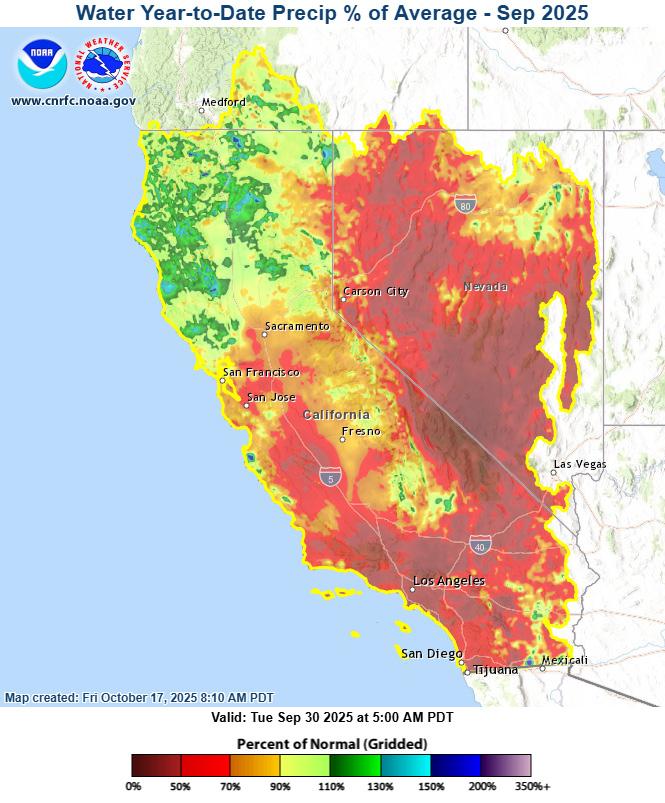
For the water year that just ended (October 1, 2024 to September 30, 2025), the precipitation has generally followed outlook forecasts attributed to La Niña conditions where we typically see normal to above normal precipitation in the Pacific northwest, including northern California, and below normal precipitation in the southern tier of the United States, including southern California (Figure 1).
Figure 1: Percent of WY Normal Precipitation (October 1, 2024-September 30, 2025). Source: CNRFC
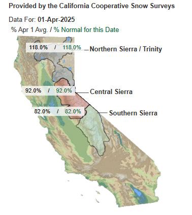
February and March 2025 helped to build snowpack in the Sierra following a dry January. The northern Sierra ended with average snowpack while the central and southern Sierra are below normal (Figure 2).
Figure 2: April 1, 2025 statewide snowpack conditions (Average date of peak seasonal snowpack). Source: CDEC
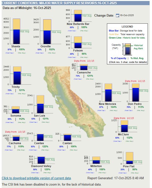
For California, current water supply storage is near the historical average for nearly all major reservoirs (Figure 3).
Figure 3: Current water supply conditions for area reservoirs. Source: CA Department of Water Resources
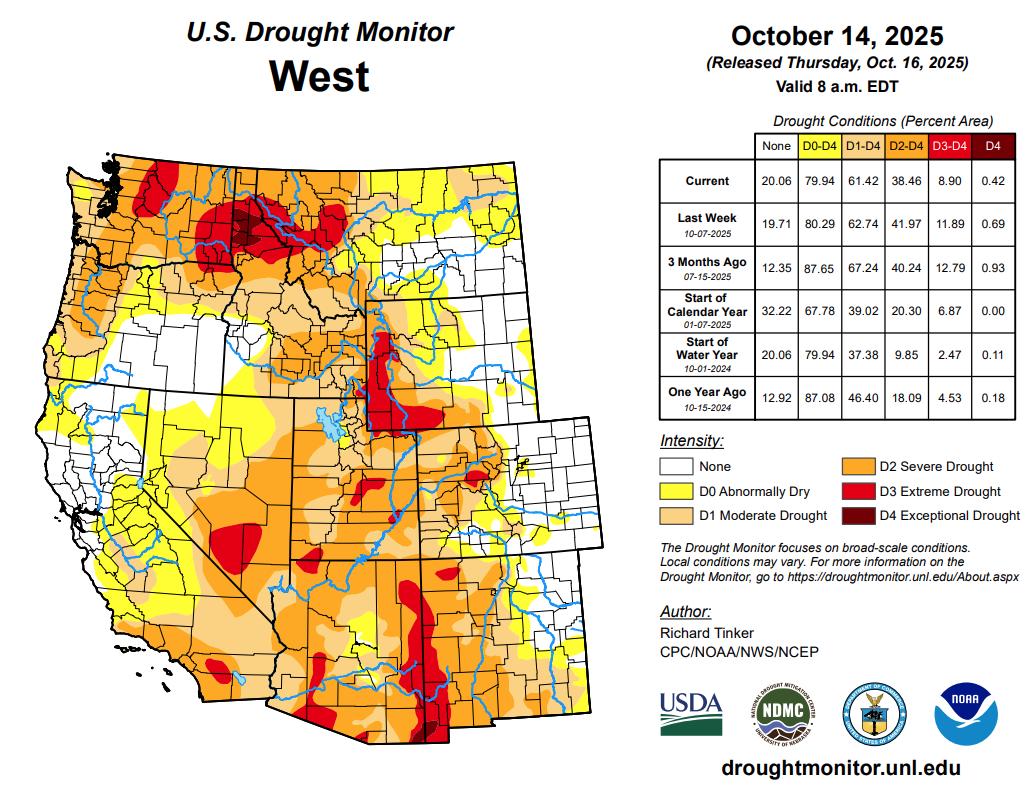
Drought conditions as depicted on the U.S. Drought Monitor Map (Figure 4) look similar to the precipitation patterns from last water year across California and Nevada. Northern California experienced above normal rainfall during the previous water year whereas Southern California and much of Nevada was below normal.
Figure 4: Current U.S. Drought Monitor Map. Source: National Drought Mitigation Center
Continued on next page
NOAA ADVISOR UPDATE (Continued)
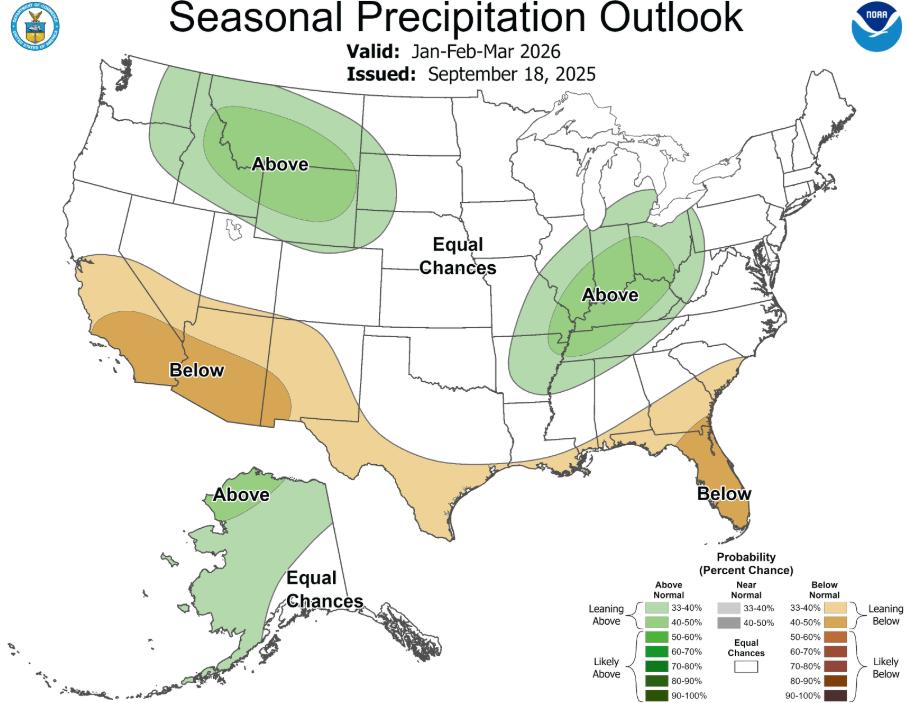
Following is the seasonal precipitation outlook for January, February, and March 2026. This is typically the wettest three months of the winter rain season in California. (Figure 5).
Figure 5: Current seasonal precipitation outlook valid for Jan-Feb-Mar 2026. Source: Climate Prediction Center


LIQUID ASSETS: FUNDING RURAL FLOOD PROTECTION IN 2025
Triston Foley, John Bliss, and Jacqueline Sullivan
At this year’s Flood Management Association Conference, SCI Consulting Group presented “Liquid Assets: Funding California’s Rural Flood Districts in 2025 and Beyond.” The session focused on how rural reclamation districts in the Delta are working to secure long-term funding for flood protection, often after decades of underinvestment.
California’s Delta communities face some of the state’s greatest flood risks. The levees, many built more than seventy years ago, still protect farms, homes, and infrastructure from catastrophic flooding, but the funding that supports them has not kept pace. Many districts continue to rely on outdated assessments that no longer reflect the true cost of maintenance. Updating these tools is never simple because they require property owner approval, but recent examples show progress is possible.
Empire Tract (RD 2029) is a small community that created a dedicated loan repayment assessment. Trustees sat down individually with every landowner to build understanding of the financial situation and answer their questions, resulting in unanimous approval of the measure. This approach showed how direct, personal outreach can unite even skeptical landowners around a shared financial challenge.
Egbert Tract (RD 536) needed a methodology that reflected the reality that homes, rather than farmland, would face the greatest losses in a flood. By focusing on this home-centered approach and communicating it clearly to property owners, the district secured strong support for the new assessment, which now generates roughly $600,000 in stable funding each year.
Sherman Island (RD 341) previously relied on an assessment from the 1990s with no adjustment for inflation. Because the State of California owns most of the land, outreach required a tailored approach. By working directly with state representatives, the district won 99 percent approval and the assessment brings in nearly $600,000 annually.
Bethel Island (BIMID) needed to renew its expiring 2015 assessment. With nearly 2,000 parcels and a wide mix of property types, a clear explanation of how rates reflect differing levels of benefit was critical. Through in-person and online meetings, BIMID earned 85 percent support to continue generating about $285,000 annually.
The common threads across these efforts are clear. First, direct outreach matters more than anything else. Whether it is one-on-one conversations, small group discussions, or large community meetings, property owners support assessments when they have the chance to ask questions and receive straightforward answers. Second, transparency builds trust. Explaining how rates are set, what benefits each property receives, and what happens if funding falls short makes the process credible. Lastly, tailoring communication to the unique circumstances of each district is critical. From focusing on residential risk to engaging with large landowners or state officials, strategies have to reflect the realities on the ground.
These lessons carry beyond individual case studies. Rural reclamation districts are chronically underfunded, but when they approach landowners with honesty, clarity, and accessibility, they can secure the resources needed to maintain their levees and protect their communities.
ADAPTING SAN FRANCISCO BAY TO RISING SEAS: LESSONS FOR FLOODPLAIN MANAGERS
Kees Nederhoff (Deltares USA), Rohin Saleh (Aquaflows)
THE CHALLENGE
San Francisco Bay is one of the most urbanized estuaries in the US. It has over seven million residents and hundreds of billions of dollars of infrastructure and is being threatened by an increasing likelihood of flooding from rising seas, more severe storms, and eroding flood defenses.
For floodplain managers, the Bay is a lesson in complexity. A number of drivers, ranging from river flows, tides to sea level rise, interact in ways that produce both expected and unexpected flood risks. Local governments are pondering whether to make an investment in adaptation: do they raise the levees higher, restore wetlands or consider mobile floodgates?
To attempt to answer these questions, we used the Delft3D San Francisco Bay-Delta Community Model (a high-resolution hydrodynamics model available on www.d3d-baydelta.org) to simulate the effects of different adaptation options on peak water levels. We did not intend to provide one solution, but rather to provide indicators of trade-offs and allow managers to make informed decisions. This article is based on a recently published journal article published in Journal of Waterway, Port, Coastal, and Ocean Engineering1.
WHAT WE FOUND
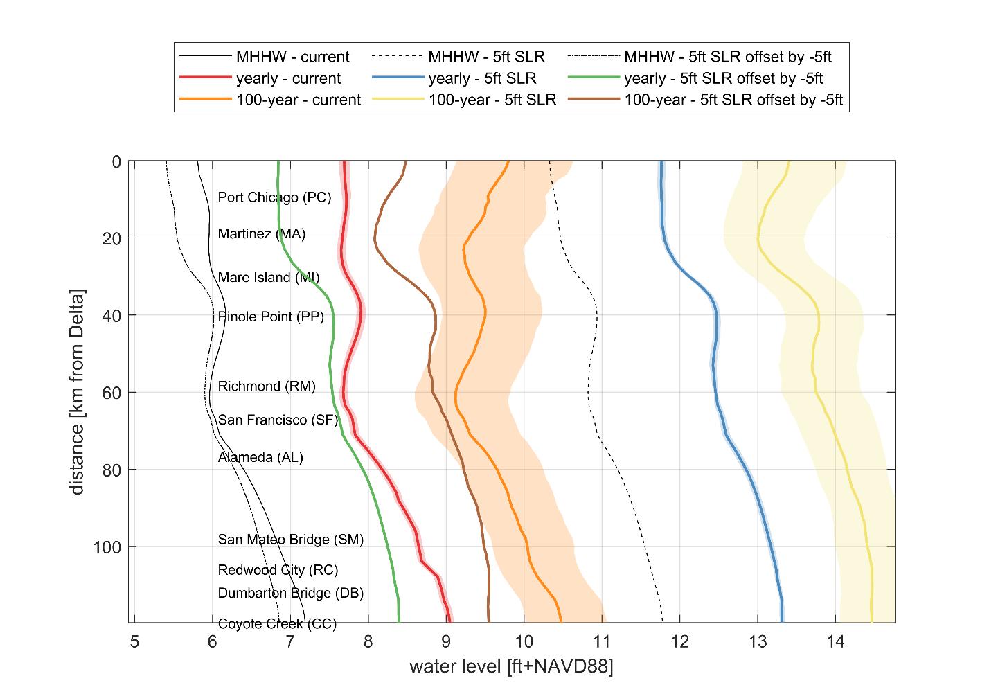
1. Tides matter more than storms in this estuary.
Maximum water levels in the San Francisco Bay are largely tidal. At most locations, tides contribute 2 to 3 ft to the high water level, and surge adds several inches up to 1 ft2. That means that local shoreline conditions play an important role in flood risk. Tides do not rise evenly throughout the Bay. For example, the mean higher high water (MHHW) in the South Bay is more than 1 ft higher than at the Golden Gate in San Francisco. This is due to the way the incoming tide travels through the Bay’s long, narrow channels and shallow basins. As the tide moves inland, it is constricted and reflected, making it rise even more, a process called tidal amplification and akin to splashing water around in a bathtub
2. Sea level rise will not raise tides evenly. You might think that if the ocean rises by 5 feet, every high tide in the Bay would also be 5 feet
higher. But the Bay doesn’t work like that. As the water gets deeper, tides can spread out more easily, so they don’t always stack up as much. In some parts of the Bay, this means high tides actually end up a little lower than expected. For example, with 5 feet of sea level rise, extreme tides can be about half a foot lower than a simple “add-on” guess would predict. Flooding will still get worse, but in some places the increase will happen more slowly than you might expect.
3. Hard shorelines versus soft shorelines yield different results.
Hard shores (seawalls and levees along the waterfront) have a tendency to increase tides, raising flood levels in certain areas. On the other hand, restored wetlands reduce tide and can thus moderate extremes. For example, restored wetlands reduced peak flood levels by up to half a foot in parts of the South Bay in our experiments. The current shoreline, which mixes hard and soft elements, produces intermediate results.
4. Floodgates can help—up to a point. We evaluated four proposed floodgates (San Leandro Bay, Mill Valley, Napa River, Dumbarton Bridge). Properly timed closures lowered peak water levels locally without major side effects elsewhere in the Bay. However, when sea level rise is more than 3 to 6 ft, the gates no longer work as water has other paths around them, flooding low-lying land.
WHY IT MATTERS FOR FLOODPLAIN MANAGEMENT
The important point is that there is not one solution that will solve San Francisco Bay’s flood issue. Instead:
1. Mix approaches. Hard infrastructure may be required in some areas, but this must be mixed with wetland restoration and setback levees that preserve ecosystem function.
2. Ensure thresholds. The majority of local measures operate up to about 3 to 6 ft of sea level increase. Beyond this, regional-scale interventions (e.g., coordinated floodwalls) may be necessary.
3. Coordinate beyond borders. The hydrodynamics of the Bay are indifferent to city or county borders. A restored wetland in one county can lower water levels in another. Likewise, a levee built in one community can shift risk to adjacent ones. Regional coordination is required.
BROADER IMPLICATIONS
Although our study site just so happens to be San Francisco Bay, lessons are transferable to other estuaries and floodplains nationwide:
• Floodplain managers can expect nonlinear responses. Sea-level rise does not simply “stack” on top of tides. Complex interactions can mute or amplify extremes.
• Nature-based solutions are part of the toolkit. Wetlands and living shorelines won’t replace levees, but they can work alongside them to lower peak water levels and provide added benefits like habitat and carbon storage. How much protection they offer depends on the setting, so measuring and modeling their effects is essential.
• Floodgates are effective short-term tools, but not long-term answers. They can buy time but ultimately do not remove the need for comprehensive, regionalscale planning.
LOOKING AHEAD
Figure. Water levels along the thalweg of the San Francisco Bay, shown as distances from the Sacramento-San Joaquin Delta (“Delta”) under current baseline conditions, a 5 ft sea level rise (SLR) scenario, and relative changes after adjusting for SLR, highlighting variations in extreme water levels. The three positions shown are Mean Higher High Water (MHHW), yearly extreme water level, and the 100-year water level. Shaded areas indicate the 95% confidence interval (CI) for yearly and 100-year water levels displayed for the current and 1.5-meter SLR scenarios but omitted for the relative changes.
San Francisco Bay is making a big bet on adaptation planning, from the Shoreline Adaptation Atlas to large restoration projects. Models like the Bay-Delta Community Model give planners a quantitive tool of how today’s choices will play out under tomorrow’s water levels.
For managers of floodplains, the message is simple: the best path forward is a pragmatic mix of steps, informed by science and coordinated over boundaries. What works in one decade or one location might need adjusting in the next.
As seas rise, defending property is only part of the problem. It’s figuring how to defend flood safety, ecosystem integrity and regional fairness. Models cannot be programmed to answer those values, but they can help flood plain managers provide quantitive numbers to support decision making.
References
1. Nederhoff, K., Saleh, R., Barnard, P., & Stacey, M. (2025). Mitigating Flood Risks in Urban Estuaries: Tidal Dynamics, Shoreline Hardening, Nature-Based Solutions, and Floodgates in San Francisco Bay. Journal of Waterway, Port, Coastal, and Ocean Engineering. https://doi. org/10.1061/JWPED5.WWENG-2342
2. Nederhoff, K., Saleh, R., Tehranirad, B., Herdman, L., Erikson, L., Barnard, P. L., & van der Wegen, M. (2021). Drivers of extreme water levels in a large, urban, highenergy coastal estuary – A case study of the San Francisco Bay. Coastal Engineering, 170, 103984. https://doi. org/10.1016/j.coastaleng.2021.103984
NAVIGATING THE TIDES OF CHANGE: THE FUTURE OF THE NATIONAL FLOOD INSURANCE PROGRAM
Kathleen Schaefer, Ph.D., P.E., CFM
At midnight on September 30, 2025, the National Flood Insurance Program’s (NFIP’s) authority to issue flood insurance expired. Before it expired, the NFIP was the world’s largest flood insurance provider, providing $1.3 trillion in flood insurance coverage to 4.7 million policyholders in 23,000 communities across the United States. This time, unlike the 33 previous times it expired, there was no one in Congress to author yet another short-term extension. Several members of Congress from Louisiana and Mississippi introduced legislation some time ago to extend the federal authorization for the NFIP through December 31, 2026. It is yet to pass.
For California residents, the lapse of the NFIP may not be as problematic as in other states. With only about 200,000 NFIP policies, California represents a small portion of the program; the lapse creates an opportunity for private flood insurance as an alternative to the NFIP. While private flood insurance can sometimes be more expensive, it is not always the case, and it often provides broader coverage. For example, private policies may cover additional property types, such as detached garages or landscaping, or offer higher coverage limits than NFIP policies.
For those who are not required to buy flood insurance but choose to do so, private flood insurance presents other options such as wraparound insurance, which supplements existing coverage, and parametric insurance, which pays out based on predetermined event parameters rather than the actual losses incurred. For instance, a homeowner who wants protection against business interruption or temporary relocation might benefit from a wraparound policy that fills gaps left by basic coverage. At a recent convening of insurance providers by the Department of Insurance, the overwhelming message from private providers was that supply is not the issue; rather, there is a lack of demand. What does the lapse mean for existing homeowners?
Existing NFIP policies will remain in effect until the policy expires, including a 30-day grace period, and claims will continue to be paid. However, the NFIP cannot issue new or renewal flood insurance policies until the program is reauthorized.
What does the lapse mean for new homebuyers?
Insurers may assign the seller’s NFIP policy to the buyer simply by substituting names, so coverage on the property is maintained and a new policy does not need to be issued. Most federal lending regulators suspend the flood insurance purchase requirement during a lapse, leaving lenders to decide whether to make loans in special flood hazard areas when NFIP insurance is unavailable. Lenders may continue to make loans without flood insurance coverage during this time, but must continue to make flood determinations; provide timely, complete, and accurate notices to borrowers; and comply with other applicable parts of the flood insurance regulations. In addition, lenders are encouraged to evaluate safety and soundness and legal risks, and to prudently manage those risks during the lapse period.
Why
is meaningful reform so elusive?
In order to understand why meaningful reform is so elusive, we need a little insurance pricing 101. Insurance can be understood as the law of large numbers applied as a service. It aims to turn a large, uncertain expense for a few into a small, predictable expense for many. Central to this process is the concept of an average annual loss (AAL). The AAL is the loss the insurance provider expects, averaged across all insured properties annually. To cover expenses, uncertainties, and other costs, the premium is typically two to three times the AAL. This markup is referred to as the load. In other words, insurance providers expect to pay claims; they make their profit by adding overhead to the AAL.
In 2022, the average NFIP payout nationally was $44,401, with California and Florida averaging $37,590 and $37,385, respectively. Let’s assume $38,000 is the average annual loss (AAL) per household. With a hypothetical $1,000 annual premium, dividing $38,000 by $1,000 gives 38 policyholders required to cover one claim. Including administrative costs and other expenses (the “load”), if these costs double the required amount, nearly 100 policyholders are needed. In other words, $100,000 in premiums is needed to cover one $38,000 loss.
Interestingly, data suggests that halving the premium to $500 could potentially double participation rates.
Leading to a compelling question: Could a $500 annual premium program be viable? Under this model, 200 policyholders would be needed to cover each $38,000 loss.
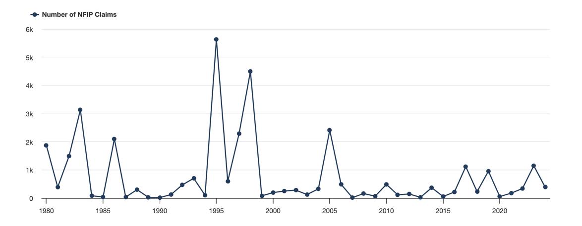
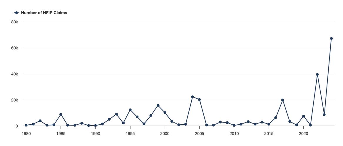
In 2022, California reported 78 NFIP claims. Using our example, to remain solvent with a $500 premium, California would need 15,600 policyholders without a claim. Given that the state had 203,929 policies in force that year, this arrangement appears feasible. Florida, with 4,288 claims, would require 857,600 policyholders with no claim (Figure 1). With 1,714,008 policies in force, Florida also seems capable of sustaining this model (Figure 2).
However, it’s crucial to note that flood events can vary dramatically year to year. For instance, just two years later, Florida experienced 67,054 claims with an average payout of $113,219, totaling $7,791,793,726 in payouts. This extreme variability underscores the challenges in maintaining long-term financial stability for flood insurance programs. Clearly, less doable.
This analysis offers insights into why reforming the NFIP is so difficult. This dilemma of California flood insurance—financially doable, Florida flood insurance— less financially doable presents a challenge for the NFIP reformers and an opportunity for the private market. Any reform will impose a significant burden
Continued on next page
Figure 1: California Claims Data from Floodsmart
Figure 2: Florida Claims Data from Floodsmart
NAVIGATING THE TIDES OF CHANGE: THE FUTURE OF THE NATIONAL FLOOD INSURANCE PROGRAM (Continued)
on states like Texas, Louisiana, and Florida that have disproportionately benefited from the low-cost flood insurance in the past. What is generally overlooked is that a failure to reform the program will make private insurance more attractive in places like California, decreasing the number of NFIP policies nationwide. With the lapse of the NFIP and the increase in private insurance options, what is the future of the NFIP?
There is bipartisan agreement that the NFIP, in its present form, is not financially sustainable. In a 2018 USA Today op-ed, FEMA Directors Fugate and Paulison summed up the state of the NFIP: “Right now, our country is using the policies and standards of yesterday to pay for today’s floods with tomorrow’s money.” But contrary to what some doomsayers may claim, the NFIP is likely to continue to exist in some form for some time. A fully private market may not be feasible for states like Texas, Florida, and Louisiana—just yet. However, the NFIP may ultimately collapse under its own weight. It is currently $22.5 billion in debt and has a $2 million per day debt payment. As private options become more prevalent, the NFIP will have fewer policyholders to pay the debt service.
To counter the loss in policies, entities like ASFPM are pushing to make insurance mandatory in the 500year floodplain. Mandatory purchase in the 500-year floodplain could dramatically increase insurance costs for homeowners and businesses, potentially leading to economic hardship and reduced property values across California. After years of taxing themselves to get to a 200-year level of protection, mandatory purchase in the 500-year will not be welcomed by California property owners.
Although the NFIP will continue to exist in some form for some time, in an era of more frequent and severe storms, the federal government has proven unable to price flood risk accurately, and this is unlikely to change anytime soon.
What is the political future of the NFIP?
In 2023, Senator Mendez proffered a comprehensive reform bill. Before this last lapse, Senators Cassidy and Booker asked for comments on the Mendez reform bill. They received over 10,000 comments
Among the 10,000 comments were comments from the American Bankers Association, which called for a more holistic rethinking of how all natural disasters (wind, fire, earthquake, and flood) intersect with mortgage finance. They urged Congress to expressly recognize private flood insurance policies that are equivalent to NFIP coverage as satisfying the continuous coverage requirement and to avoid penalizing borrowers by removing their eligibility for subsidized or grandfathered rates. They argued that a failure to recognize private insurance not only penalizes borrowers for shopping competitively but also discourages NFIP participation, creates a barrier to private market growth, and undermines affordability. In addition, they called for requiring FEMA to provide clear, accessible information on Risk Rating 2.0’s methodology and assumptions and to provide a formal process for stakeholder feedback. The National Association of Insurance Commissioners (NAIC) also called for more private participation, suggesting, “Greater collaboration will expand opportunities to educate consumers about their coverage options, ensuring that families understand both the NFIP and private market solutions available to them.”
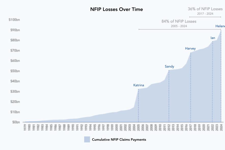
Figure 3: NFIP losses over time. Source: Neptune Flood
Of interest to FMA, NAIC had the following comment:
“Overall, in reforming the NFIP, we urge federal policy makers to take inspiration from the state level actions and the NAIC’s centralized resources to support regulators and consumers. For example, the NAIC Catastrophe Risk Management Center of Excellence provides regulators with tools to evaluate catastrophe models and ensure pricing accuracy. Our Disaster Preparedness Guide and Resilience Hub compiles best practices and consumer education materials. The Climate & Resiliency (EX) Task Force continues to coordinate regulatory efforts on climate risk, solvency stress testing, and resilience planning.”
This signals that the NAIC is taking a stronger role in flood insurance regulation. Given this shift, FMA should reach out to the NAIC and explore the possibility of forming a partnership. Historically the NFIP has been viewed as the only game in town, but that is changing.
If the NFIP goes away or doesn’t go away, does anyone care?
Regardless of what happens with the NFIP, private insurance will grow, and floodplain management will evolve into flood risk management and ultimately into flood recovery management, making the NFIP less relevant. Financial institutions are
becoming key drivers in this transformation: their risk evaluations and lending standards increasingly shape community resilience strategies, sometimes even more than government mapping or traditional regulatory programs. Communities will be more concerned about what the financial institutions believe is their risk than what a FEMA map says. For example, after several major UK banks adopted advanced flood risk models developed in collaboration with the Climate Financial Risk Forum (CFRF), a leading US mortgage lender announced in 2024 that it would incorporate similar riskbased flood assessments into its loan approval process, resulting in more stringent lending requirements for properties in high-risk areas. Its flagship report, From Risk to Resilience, CFRF outlines practical steps for integrating climate risk management across asset classes and sectors, and demonstrates how financial institutions can unlock opportunities by investing in resilience
FMA can and should play a strong role in helping to guide the transition from flood management to flood risk management and flood recovery management. This will involve making new connections with insurance providers and the banking community. It will involve learning new skills like catastrophe modeling. It will also involve learning much more about things like insurancelinked securities, catastrophe bonds, and captives.
1 https://www.congress.gov/crs-product/R45999
2 https://www.floodsmart.gov/historical-nfip-claims-informationand-trends?map=countries/us/us-fl-all®ion=us-fl&miny=all&max y=all&county=>ype=state.
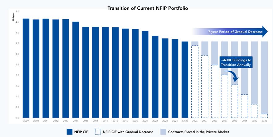
Figure 4: Estimate of the transition to private flood insurance. Source: Neptune Flood
“SILVER
JACKETS:
NOT JUST FOR DISCO” - WHAT ARE SILVER
JACKETS TEAMS?
Danae Olsen
Silver Jackets teams are interagency teams that work together to reduce the risks of flooding and sometimes other natural hazards. Teams are state-, territory-, or tribal-led and exist in all states and several territories, bringing together state, federal, and sometimes local agencies and Tribes to learn from one another and work together.
So, how did the name “Silver Jackets” come about? During disaster response, agencies are often identified by the color jacket or shirt they wear. For example, FEMA has typically worn blue jackets or shirts and USACE has worn red. The name ‘Silver Jackets’ was coined to represent many agencies working together to tackle flooding issues.
Using an interagency method of delivery, Silver Jackets teams develop and conduct diverse collaborative efforts. Team focal areas vary as state priorities vary. By applying their shared knowledge, the teams enhance flood preparedness, mitigation, response, and recovery efforts. Resources for team activities are provided through the individual programs of each participating agency, within the constraints of available budgets and authorities.
No single agency has all the answers. Leveraging the expertise, programs and perspectives of multiple agencies can result in more comprehensive and cohesive solutions. To learn more, visit: https://www.iwr.usace. army.mil/Silver-Jackets/
Silver Jackets 20th anniversary and a little history of how it started
In 2025, the Silver Jackets celebrated their 20th anniversary! The very first pilot teams in Ohio and Indiana were established in 2005 and 2006,
respectively. Since the formation of the first pilot teams, 54 Silver Jackets teams have formed in all 50 states, four territories (American Samoa, Guam, Puerto Rico, and U.S. Virgin Islands), and the District of Columbia, each coming together to facilitate collaborative solutions to State, Territory, or Tribe flood risk priorities.
The Silver Jackets program supports the development and facilitation of state, territory, or tribe led Silver Jacket Teams and involvement in other intergovernmental and intra-agency teams throughout lifecycle of floods and other natural hazards, from mitigation through advance planning, emergency response, and recovery. This function directly supports achievement of Executive Order 14239 (Achieving Efficiency Through State and Local Preparedness) in particular empowering state and local governments to “play a more active and significant role in national resilience and preparedness” and “ensure State and local governments and individuals have improved communications with Federal officials”.
How does Silver Jackets promote community resilience?
Silver Jackets interagency efforts often result in meaningful outcomes for communities, especially when the community partners are an involved part of the project team.
Although each state’s Silver Jackets team is unique, common agency participants include state agencies with mission areas of hazard mitigation, emergency management, floodplain management, or natural resources conservation. Federal participation typically includes the Federal Emergency Management Agency, National Weather Service, U.S. Army Corps of Engineers, U.S. Geological Survey, as well as the Natural Resource Conservation Service, Environmental Protection Agency, among others. Some teams include membership from Tribes and academic institutions, regional and local government, and non-governmental organizations.
Activities range throughout the flood risk management lifecycle and promote shared responsibility. Team activities have included state hazard mitigation plan updates, inundation mapping, tabletop exercises, development of emergency action plans, risk communication workshops, and coordination of
perishable data collection, and many others.
Silver Jackets is not a silver bullet, but Silver Jackets teams collaborate on efforts that may lead to larger studies and more complex projects. Project ideas that originate with Silver Jackets teams often lead to interagency efforts with meaningful outcomes and collaborative impact on issues surrounding flood risk management.
Gathering in Person to Celebrate Project Successes and Chart Path Forward
The California Silver Jackets gathered both in person and virtually at the Floodplain Management Association Conference in Sacramento to discuss recent and upcoming activities. Jessica Ludy and Danae Olsen provided an overview of the program, its history, and the state team’s charter. Sarah Fichtner, State Lead for the Nevada Silver Jackets Team, described their projects and progress. Meeting participants then broke out into smaller groups to discuss the issues and problems in the flood management community. Each group identified potential projects that could address these challenges, as well as brainstormed near-term solutions and discussed partner strengths and resources. These ideas will be incorporated into future project proposals. At the end of the meeting, the team leads presented the Col. Morrison Collaborative Leadership Award to this year’s winner.
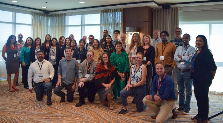
Caption: Current and future Silver Jackets Team members--past, present, and future.
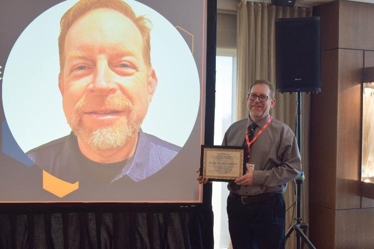
Recognizing Excellence in Flood Risk Management and Collaboration
Col. Carleton “Carl” Morrison, Jr., was a well-respected, collaborative leader within the California flood risk management community, including Silver Jackets. After his sudden passing in 2018, the team established this award in his honor.
This year’s Col. Morrison Award recipient is Michael D. Mierzwa, Technical and Policy Advisor at the California Department of Water Resources. For more than a decade, Michael has been a steadfast champion of the California Silver Jackets, embodying the spirit of collaboration, leadership, and dedication that defined Col. Morrison’s legacy. His commitment to multiagency coordination and his ability to foster trust across federal, state, local, and tribal partners have made him a cornerstone of California’s flood risk management community.
We would love to have you join us! If you are interested, sign up for our mailing list at https://forms.office. com/g/vUNtGBEj0q or use the provided QR code. Contact Nikki Blomquist at Nikki.Blomquist@water. ca.gov if you have any questions about the program.

Caption: Michael D. Mierzwa accepts the Col. Morrison Award at the Silver Jackets’ Annual Meeting in Sacramento.
ADVANCING ALLUVIAL FAN MAPPING METHODS USING 2-D H&H ANALYSES
Ron Coupland, Wilson & Company, Inc.
Alluvial fan floodplain mapping and flood risk characterization is an important undertaking that is intended to improve the understanding and awareness of public safety concerns and to facilitate regulation of development. It is a balance between quantitative and qualitative assessments – combining hydraulic and geomorphic analyses with professional judgment to interpret complex, uncertain flow patterns. The conference session that was given on this topic focused on advancements in the science, which in turn allowed for a more robust interpretation of the flow path and flood risk uncertainty that was reflected in the mapping. In other words, using a detailed two-dimensional (2-D) hydrologic and hydraulic (H&H) modeling approach for both the existing conditions and a potential worst-case flow path uncertainty scenario made it possible to better account for uncertainty when delineating the Special Flood Hazard Areas (SFHA) on the alluvial fan landform. The flow path uncertainty scenario simulated a change in flow patterns due to sediment deposition/aggradation. This approach will be explained in further detail below.
Communities across the desert southwest, where alluvial fans are prevalent, continue to update flood hazard studies to better understand and prepare for potential flooding and the Town of Pahrump, located in Nye County, Nevada, is a community where that information is much needed. Given the extensive flooding and storm damage this area experiences on a regular basis, primarily from the Wheeler Wash Fan, the Pahrump Phase I & II Risk MAP Projects were conducted to provide the Town, County, and FEMA with updated H&H modeling (Phase I) and floodplain mapping (Phase II).
The latest flood hazard analyses prior to these Risk MAP Projects were completed in 2011, but the Flood Insurance Rate Map (FIRM) panels for the majority of the Town were not updated at that time. The FIRM panels date back to around 30 years ago and were based on FEMA FAN model methodology. The entire central part of the Town from the Wheeler Wash Fan apex to the CaliforniaNevada state line was mapped into an alluvial fan flood hazard based on this approach. It was time for the risk assessment and FIRM panels to be updated.
The 2-D H&H analyses were based on FLO-2D Pro modeling methodology, aerial imagery and detailed
topographic mapping flown in 2022, NOAA Atlas 14 precipitation data, detailed surface feature classification coverage, and detailed soils mapping. The 306-squaremile watershed was modeled using 10 computational sub-watershed domains defined by grids having square elements measuring 20’ x 20’ – for a total of approximately 21 million grid elements. Rainfall losses were estimated using the Green & Ampt infiltration methodology with limiting infiltration depths validated using HEC-1 Green & Ampt rainfall loss modeling results. Hydraulically significant culverts and flow-diverting property walls were included in the modeling effort. Two alluvial fans landforms, including Wheeler Wash Fan, were identified within the watershed, and modeling of potential flow path uncertainty was conducted.
As mentioned above, alluvial fan flow path uncertainty was simulated based on assumed sediment deposition immediately downstream of the fan apex and was based on the following two criteria:
• The elevations of grid elements having a 100-year, 24-hour maximum flow depth less than 1-foot were raised by 1-foot.
• The elevations of grid elements having a 100-year, 24-hour maximum flow depth of at least 1-foot were raised by the existing condition maximum flow depth.
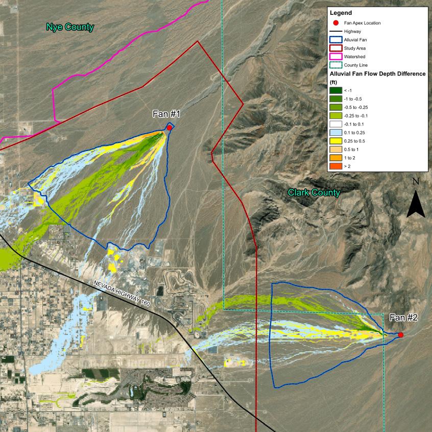
When comparing modeling results, the existing conditions versus the sedimentation uncertainty scenario show relatively little difference between flow pattering, extent, and/or magnitude at the downstream limits of the alluvial fan landforms. This is due to the presence of relatively well-formed piedmont channels downstream of the fan apex, which have the capacity to convey significant flow even with reduced capacity. There is also significant distance between the alluvial fan apex and downstream limits of the alluvial fan landform, allowing flow to “normalize” even under material deposition conditions at alluvial fan apex. The difference in maximum flow depths when comparing existing conditions and post-deposition conditions is shown below in Figure 1.
The H&H modeling results from the Pahrump Phase I Risk MAP Project have been reviewed and approved by FEMA for regulatory use and correlate well with historically reported flooding. The approved H&H modeling results are the basis for remapping of regulatory floodplains. The Pahrump Phase II Risk MAP Project entailed remapping of approximately 63 square miles of effective floodplain, including approximately 38 square miles of Zone AO floodplain, 0.2 square-mile of Zone A floodplain, and seven linear miles of Zone AE floodplain. Providing additional complexity was the remapping of the Wheeler Wash alluvial fan flood hazard. FEMA guidance outlines the following threestage alluvial fan flood-hazard delineation process:
• Stage 1: Recognizing and characterizing alluvial landforms.
• Stage 2: Defining active and inactive areas.
• Stage 3: Defining the 1-percent-annual-chance flood within defined areas.
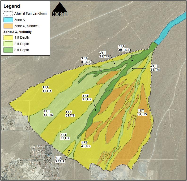
As discussed above, the currently effective alluvial fan FEMA SFHA (Zone AO with Velocity) covers the majority of the central part of the Town. This effective mapping implies that the portion of the Town within this SFHA is within an active alluvial fan. The primary goal of the Pahrump Phase II Risk MAP Project was to reevaluate the previous assumption that the Town, a developed area within an historic playa, is subject to alluvial fan flow path uncertainty. For various reasons, including a rapid decrease in topographic slopes and velocities, as well as the lack of further fanning out of the flow at the toe of the fan landform, the alluvial fan analysis clearly shows that the alluvial fan landform is restricted to the desert rangeland area upstream of existing Town development.
The FEMA flood zone revisions include mapping of the active alluvial fan areas as Zone AO with velocity and mapping of the inactive alluvial fan areas as Zone X. The active areas apply depth and velocity values derived from a composite worst-case scenario of existing condition
Continued on next page
Figure 1. Flow Depth Comparison (Uncertainty Scenario minus Existing Condition maximum 100-year, 24-hour storm event flow depths. Wheeler Wash Fan is Fan #1. Lovers Wash is Fan #2.)
ADVANCING ALLUVIAL FAN MAPPING METHODS USING
2-D H&H ANALYSES (Continued)
and alluvial fan uncertainty scenarios as shown in Figure 2. The proposed alluvial fan floodplain mapping is quite detailed compared to the typical conical-style flood zones that are normally seen on effective FIRM panels. The 100-year, 24-hour uncertainty scenario maximum flow depths are shown for reference in Figure 3. The Pahrump Phase II Risk MAP Project alluvial fan floodplain mapping has been reviewed by FEMA. All comments on the FEMA review of the alluvial fan floodplain mapping have been resolved.
The benefit of having alluvial fans mapped is that regulation is enforceable by floodplain administrators under the NFIP. For local floodplain managers, the
approaches discussed above justify adjusting the mapping of alluvial fan flooding hazards within any given jurisdiction. Area Drainage Master Plans that characterize alluvial fan flood risk are considerably beneficial and special consideration should be given to mapping of these high-risk areas – particularly those areas having significant population sizes.
Feedback is welcomed from FMA members interested in applying these techniques or sharing their own mapping experiences. Presentation slides and a project summary are available upon request at ronald.coupland@ wilsonco.com
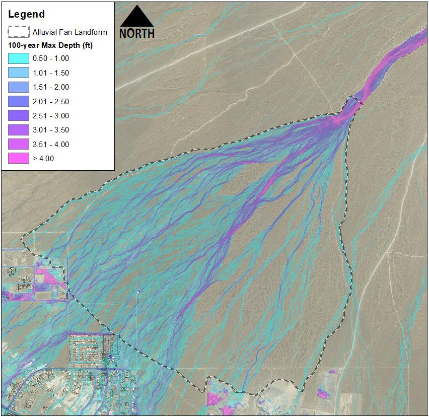
Figure 2. Wheeler Wash Alluvial Fan proposed floodplain mapping.
Figure 3. Wheeler Wash Uncertainty Scenario 100-year, 24-hour storm event maximum flow depths.
Solving the most pressing water-related issues to improve our region’s built and natural environments

Water Resources Planning
Program Management
Environmental
Geotechnical
Civil Design
Construction Management
Information Management
Grant Writing
EMERGING PROFESSIONALS COMMITTEE
Rianne Okamoto
General Updates
• Welcome Teanna Quach as Vice Chair of the committee!
• We are excited to welcome 6 new Emerging Professionals into new leaclership positions in our committee!
• We have a few vacancies, and we would welcome introductions to engaged and interested EPs from your companies/agencies.
о Bay Area Regional Events Coordinator(s)
• During this next 2025-26 cycle, we set the following goals for the committee.
о Strengthen Outreach & Visibility
о Improve Event Planning & Consistency
о Develop Sponsorship Opportunities
о Enhance Member Communication & Value
Events
• Future events will still be posted on our FMA EP EventBrite.
• https://www.eventbrite.com/o/fina-emergingprofessionals-268163 50587
• Still Pursuing up to 2 events per month in the various regions. Example event:
Membership Survey
• FMA EP Membership Survey. linked below, will add you to our email distribution list. Please share with anyone who may be interested.
• https://docs.google.corn/forms/d/ e/1FA1pQLSfRL EED-rAD9F2mba flow xinLHEQ y2a876l oSvtzG I oOl‹INbA/ ice form
Sponsorship and Reimbursement:
• Exploring additional sponsorship opportunities.
• Would like to discuss best practice for paying for our events, whether we continue to contact George or just submit reimbursements.


BEYOND THE WORKPLAN: COLLABORATIVE GOVERNANCE IN COMPLEX INFRASTRUCTURE PROJECTS
Kristyne Van Skike, PMP
HOW THE PMI TALENT TRIANGLE CAN HELP FLOODPLAIN MANAGERS LEAD WITH PURPOSE
“Have you ever considered earning your PMP? If you work in floodplain management, you may already be practicing many of the skills it recognizes.”
Floodplain management is inherently complex. It requires balancing technical, environmental, and community needs—often across multiple jurisdictions and regulatory frameworks. That’s why the Project Management Professional (PMP) certification, and the Project Management Insititute’s PMI Talent Triangle that supports it, can be powerful tools for professionals in our field.
In California’s Central Valley, project management is about more than timelines and deliverables. It’s about navigating complexity, building trust, and aligning diverse interests toward a shared vision. And that’s where collaborative governance comes in.
Why Water Projects Are So Complex
Water infrastructure projects don’t belong to a single agency or interest group. They involve federal, state, local, tribal, and community partners—each with their own priorities, timelines, and constraints. These aren’t just stakeholders; they’re powerholders.
Managing these relationships requires more than technical expertise. It requires empathy, influence, and strategic insight.
PMI Talent Triangle:
• Business Acumen
• Ways of Working
• Power Skills
Business Acumen: Understanding the System

Floodplain projects are shaped by policy, funding, and public perception. Business Acumen means understanding the broader landscape—how decisions are made, who holds influence, and what opportunities exist.
In the Central Valley, this means aligning projects with state and federal priorities like the Central Valley Flood Protection Plan (CVFPP) and leveraging funding streams to move projects forward.
Ways of Working: Adapting to Complexity
Traditional project delivery models don’t always fit the realities of floodplain management. We use adaptive planning, phased implementation, and systems thinking to stay flexible and responsive.
“We treat governance itself as a delivery system—with its own critical path.”
In the Yolo Bypass, for example, we’re coordinating a federal feasibility study, a regional master plan, and a multi-agency partnership. Each has its own scope and timeline, but they’re all connected by a shared vision.
Power Skills: Building Trust and Alignment
At the heart of collaborative governance is relationship management. Power Skills—like facilitation, empathy, and influence—are essential for building trust and maintaining alignment.
We use stakeholder mapping, facilitated workshops, and co-design processes to ensure projects reflect shared values. These tools don’t eliminate conflict, but they help us navigate it productively.
Case Study: The Yolo Bypass
The Yolo Bypass Cache Slough (YBCS) region is a living example of collaborative governance in action. Here, we’re managing:
• A federal comprehensive study with the U.S. Army Corps of Engineers
• A regional master plan with state and local partners
• A multi-agency partnership with 16 signatories and over 1,100 stakeholders
To keep these efforts aligned, we apply all three dimensions of the Talent Triangle—strategic insight, adaptive planning, and relationship-building.
“This isn’t just project management—it’s systems leadership.”
What This Means for Floodplain Managers
Whether you’re managing a levee improvement, a habitat restoration, or a community engagement process, the same principles apply:
• Map your stakeholders early—and revisit often
• Design your process as intentionally as your project
• Use adaptive tools like phased planning and scenario analysis
• Invest in relationships—because trust is the foundation of success
And if you’ve ever thought about earning your PMP certification, now might be the time. The Talent Triangle isn’t just a credentialing framework—it’s a practical guide for leading in complex environments.
Final Thought: Leading with Purpose
Floodplain management is about more than infrastructure. It’s about protecting people, places, and ecosystems. It’s about making decisions that reflect our values which include safety, equity, stewardship, and collaboration.

As project managers, we have a unique opportunity to lead with purpose. By embracing the full range of skills in the PMI Talent Triangle, we can help ensure our projects deliver real, lasting benefits for the communities we serve.
Let’s keep building that future—together.

BUILDING FLOOD-SMART COMMUNITIES: WHY EDUCATION TOOLS MATTER AND HOW TO BUILD THEM EFFECTIVELY
Yi Ling Chan, CFM
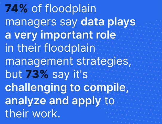
Flood risk awareness is one of the cornerstones of community resilience. Despite decades of progress in mapping, modeling, and mitigation, many residents remain uncertain about the flood hazards around them.
In a survey conducted by Forerunner, 30 percent of floodplain managers reported that their communities lack awareness of their flood risks.
This education gap poses a serious challenge. When residents are unaware of their exposure, they are less likely to prepare, mitigate, or respond effectively. They may be unaware of flood insurance and permitting requirements, or build in high-risk areas. A community’s flood resilience program depends not only on policy or engineering; it depends on how well people understand their risk.
At the same time, floodplain managers face increasingly complex demands. They are responsible for permitting, compliance, planning, and public engagementoften with limited staffing and resources. Given these constraints, the path forward lies in leveraging tools to make risk communication clear, consistent, and actionable.
WHY FLOOD EDUCATION MATTERS
Flood education is a foundational task. When residents understand risk, they make better decisions about where to live, how to protect their property, and how to respond when floods occur.
Transparent communication builds trust. When local governments share flood data openly, residents feel empowered rather than excluded from the process. Public trust grows when communities can see how risk information informs planning, mitigation, and recovery decisions.
Clear guidance enhances compliance. Many property owners find permitting and floodplain regulations confusing. Clear explanations, especially those that translate technical requirements into digestible language, reduce frustration, prevent mistakes, and promote safer construction.
Education supports Community Rating System participation. The CRS rewards communities that invest in public information and outreach. Strong communication not only helps residents prepare but also leads to lower insurance premiums.
Equity and accessibility matter. Every resident deserves access to accurate flood information. Education efforts that prioritize multilingual resources, inclusive design, and diverse outreach strengthen the entire community.
CHARACTERISTICS OF EFFECTIVE FLOOD EDUCATION TOOLS
Effective flood education resources do more than convey information: they engage, inform, and empower communities. The most successful approaches share key characteristics that make risk communication clear, proactive, and inclusive.
1. Clarity
Clarity begins with thoughtful design. Maps, graphics, and photos give residents a tangible sense of what flood risk looks like in their own neighborhoods, turning abstract data into something they can see and understand. Using plain language instead of technical jargon and clearly explaining terms, like “Base Flood Elevation”, helps ensure that no one feels left behind. When residents can visualize and contextualize risk in this way, they are far better equipped to make informed decisions and take proactive steps to protect themselves and their property.
2. Proactivity
Proactive communication eliminates the need for residents to search for information or piece together answers on their own. A resident-first approach means anticipating the questions people will have and providing the information they need before they ask for it. This can take shape through a well-organized webpage that combines maps, permitting guidance, FAQs, and contact details with educational videos and interactive tools. Bringing all these resources together in one accessible place strengthens flood risk literacy and fosters a sense of confidence and trust between residents and their local government.
3. Accessibility
Accessible communication is the foundation of equitable flood preparedness. Information must be easy to understand, available in multiple languages, and presented in formats that work across devices and meet
accessibility standards. An accessible website is not a luxury; it is a public safety necessity. When all residents, regardless of language, literacy level, or ability, can access and act on critical flood information, communities are safer, stronger, and more resilient.
4. Integration
Flood education works best when it is woven into every aspect of local planning and communication. Connecting information about permits, recovery programs, and hazard mitigation plans helps residents see the full picture of how risk management fits together. By integrating data and messaging across departments and platforms, communities can reduce confusion, build consistency, and create a seamless experience that supports a lasting culture of preparedness.
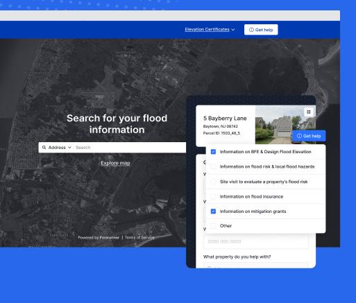
BUILDING YOUR OWN FLOOD EDUCATION HUB
Communities do not need to start from scratch to build effective flood communication tools. Many already possess the foundational data and technology; the key is organizing and presenting it in ways that are userfriendly and actionable.
Here are several strategies for building or improving your flood education hub:
1. Start with a clear structure. Design a homepage that directs residents to the most frequently sought information, such as flood maps, permitting steps, and contact details.
2. Incorporate property-specific data. Personalized insights, such as elevation or flood zone information, make risk tangible and relevant.
3. Centralize contact options. Include clear, accessible ways for residents to reach floodplain staff, such as contact forms or direct email links.
4. Encourage feedback. Use tools that allow residents to submit questions or damage reports. This feedback not only informs future outreach but also enhances community engagement.
5. Layer maps for better context. Combine flood zones, levee locations, and surge data to create a
comprehensive visualization of local risk.
6. Cross-link resources. Connect permitting information, emergency management updates, and recovery programs to reduce fragmentation and redundancy.
7. Ensure accessibility and translation. Provide resources in multiple languages and formats to reach every resident.
8. Keep content dynamic. Update materials regularly to reflect new maps, projects, or flood events.
Digital tools can transform communication efforts. Public flood risk resources serve as centralized, easyto-navigate platforms where residents can explore their flood risk, understand compliance requirements, and access critical resources.
Websites must be an interactive education hub that helps local governments communicate transparently while saving staff time. These tools strengthen community engagement, improve data transparency, and foster preparedness - all while reducing the administrative burden on floodplain management teams.
EMPOWERING COMMUNITIES
Flood risk education is more than a technical responsibility; it is a public service. It builds trust, improves compliance, supports equitable access to safety information, and strengthens resilience across the board.
For floodplain managers, the goal is not to add new tasks to already full plates, but to maximize the impact of existing efforts. By rethinking how risk information is delivered - through clarity, proactivity, accessibility, and integration - communities can close the awareness gap and prepare for the challenges of a changing climate.
When flood education is comprehensive, residents do not just understand risk - they act on it. This foundation leads to a safer, more resilient future for communities.
CALIFORNIA LEGISLATIVE HIGHLIGHTS
Ernest Conant
A couple bills recently signed by Governor Newsom of interest:
SB 72 (Caballero) directs the Department of Water Resources to modernize the California Water Plan that addresses the needs for reliable water supplies for urban, agriculture and the environment uses that is resilient to climate change. The updated Plan is due by December 31, 2028, and is to include an “interim planning target” of 9 million acre-feet of additional water, water conservation of water storage by 2040. This may further foster efforts to encourage and expedite projects to divert flood waters to groundwater storage.
AB 1319 (Schultz) establishes a process for the State to determine whether protections of endangered or threatened California native species under the Federal Endangered Species Act (FESA) have been reduced by Federal administrative actions or congressional action that were in place as of January 1, 2025. If so, the California Department of Fish and Wildlife (CDFW) is to designate the species as a “provisional candidate”, granting the species the same protections as provided under the California Endangered Species Act (CESA). This determination would remain in effect through 2031, but appears will occur without any further justification or comment process. As a result of this legislation, potential projects and operations that are currently impacted by the FESA but not CESA may continue to be affected notwithstanding the requirements under FESA being relaxed through ongoing administrative processes or congressional action.


WHAT IS A CERTIFIED FLOODPLAIN MANAGER “CFM”
George Booth
In 1998, the Association of State Floodplain Managers created a certification program to examine one’s floodplain management baseline proficiency and to encourage continuing education. FMA is authorized by ASFPM to provide continuing education in the form of seminars, workshops, symposiums and conferences.
There are hundreds of CFMs in FMA and many more who are considering becoming certified. I have been a CFM for 21 years. Having or getting the certification was a requirement of the position. The respect the certification has afforded me through my career as a local floodplain manager has been appreciated; moreover, the continuing education has been invaluable.
Every city and county, participating in the National Flood Insurance Program, must have a designated floodplain manager (aka administrator). This is often an engineer or technician, the building
Leading with Science® to improve people’s lives
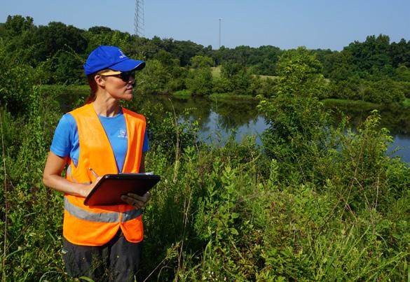


inspection chief or a planner. Many communities require that person to be a CFM. CFMs are respected within their office and with their local elected officials. When working with FEMA, being a certified floodplain manager is quite meaningful. As a CFM, participating in FMA training such as the annual conference affords the opportunity to associate with agencies. As a wise man once told me, “It is best to make a friend before you need a friend.”
Being certified as a floodplain manager doesn’t mean you suddenly have all the answers, but it will help you to formulate better questions.
To learn more, go to www.floodplain.org and click on professional development.
Tetra Tech’s innovative, sustainable solutions help our clients reach their goals for water, environment, infrastructure, resource management, energy, and international development projects.
THE HIGH WATER MARK
The Newsletter of the Floodplain Management Association