This research is funded by iMOVE CRC and supported by the Cooperative Research Centres program, an Australian Government initiative.



6-017 Easy
novel ways to engage communities around road safety: Toolkit
and
EASY AND NOVEL WAYS TO ENGAGE COMMUNITIES AROUND ROAD SAFETY La Trobe University, Centre for Technology Infusion 1 CONTENTS GLOSSARY OF ABBREVIATIONS .......................................................................................................................... 2 COMMUNITY ENGAGEMENT TOOLKIT................................................................................................................ 3 HOW TO USE THE TOOLKIT?.............................................................................................................................. 6 TECHNOLOGY SOLUTIONS FOR COMMUNITY ENGAGEMENT .................................................................................. 7 AUGMENTED REALITY.......................................................................................................................................10 MIXED REALITY ................................................................................................................................................13 GEOGRAPHIC INFORMATION SYSTEMS(GIS) .....................................................................................................16 ARTIFICIAL INTELLIGENCE ..................................................................................................................................19 WEB PLATFORMS..............................................................................................................................................23 INTERACTIVE DIGITAL SIGNAGE..........................................................................................................................25 DIGITAL TWINS.................................................................................................................................................27 WEARABLES AND SMARTPHONES.......................................................................................................................30 SPATIAL AUDIO TECHNOLOGY............................................................................................................................32 INTERNET OF THINGS (IOT) ...............................................................................................................................33 CONVERGENT TECHNOLOGIES............................................................................................................................35 REFERENCES ....................................................................................................................................................38
GLOSSARY OF ABBREVIATIONS
AI: Artificial Intelligence
AR: Augmented Reality
DT: Digital Twins
EMNS: Emergency Mass Notification System
MR: Mixed Reality
GAI: Generative Artificial Intelligence
GIS: Geographic Information Systems
GPS: Global Positioning System
IAP: International Association for Public Participation
IoT: Internet of Things
IoV: Internet of Vehicles
iRAP: International Road Assessment Programme
LGAs: Local government authorities
LiDAR: Light Detection and Ranging
ML: Machine Learning
MTurk: Amazon Mechanical Turk
NeRF: Neural radiance fields
TAC: Transport Accident Commission
VR: Virtual Reality
V2X: Vehicle to everything
XAI: Explainable AI
EASY AND NOVEL WAYS TO ENGAGE COMMUNITIES AROUND ROAD SAFETY La Trobe University, Centre for Technology Infusion 2
COMMUNITY ENGAGEMENT TOOLKIT
Introduction
The Transport Accident Commission (TAC) initiated the work on this toolkit as part of its ongoing commitment to the vision of no deaths or serious injuries on our roads by 2050; a future where every journey is a safe one.
Changes to improve road safety can be met with community objections for a variety of reasons. To ensure the community is on board with a future where every journey is a safe one, TAC must advocate and use best practice community engagement methods.
Technological innovation to support community engagement is developing at a fast pace. This toolkit aims to lower the barrier to these emerging technologies for community engagement practitioners and others who are not familiar withthem. It provides up-to-date information, use cases and examples of the types of companies that offer these services.
How can novel technologies help?
Firstly, it needs to be acknowledged that technology is only one piece of the puzzle and can only be effective if it is underpinned by a sound strategy and the resources to support its implementation. In addition, the impact of the human touch, such as having a compelling vision, being authentic, sincere, and creative outweigh the technology that’s being used to engage communities.
However, emerging technologies do make it easier than ever before to:
1 Collect data and make them publicly available
Reducing crashes and improving safety starts with the ability to identify potential issues early. Too often, unfortunately, it takes a tragic crash before the public is able to understand the risks associated with travel and support countermeasures or interventions aimed at eliminating this risk.
A better approach is to be able to engage with community and use insights gathered from community members to identify and address risksbefore crashes occur.
One way to do that is to collect data proactively and make it publicly available, which is easier and cheaper than ever. An increasing number of councils are making data available on open-source platforms, which is a powerful first step in empowering a community and pursuing evidence-based and data-driven road safety countermeasures.
EASY AND NOVEL WAYS TO ENGAGE COMMUNITIES AROUND ROAD SAFETY La Trobe University, Centre for Technology Infusion 3
The technology necessary to collect data at scale has become mainstream and affordable. This toolkit offersseveral options for collecting different types of data for various use cases and outlines methods for making them publicly available.
2 Co-create
Co-creating solutions with communities can be a complex and time-consuming process, requiring significantresources. To properly co-design solutions for safety-related issues requires engaging multiple stakeholder groups, which often represents a significant co-ordination challenge. The synthesis of feedback and communication of solutions to satisfy all relevant stakeholders can equally be a challenging task. Co-creationis therefore often reserved for larger, more complex, and more expensive projects.
Today, technology can help streamline this process so that even for recurring or small issues, stakeholders can be involved proactively. This can be achieved using one of the many community engagement feedback platforms that make data available and automate the feedback process. Furthermore, conversational artificial intelligence (AI) can be a powerful way to engage communities early.
Co-creation is more effective when the impact of suggestions or ideas can be evaluated instantly. With advances in real-time data processing technologies, whether in a digital twin or another form of simulation, the traditional divisions between ‘feasibility’ and ‘ideation’ stages in a process can be eliminated.
This toolkit provides several solutions to facilitate scalable co-creation, whether it be with small or large communities.
3 Engage participants and create immersive experiences
Mixed reality technologies provide new avenues to engage audiences in issues in which they might not haveotherwise shown interest or help visualise a future state. The use of augmented reality in particular can also help audiences understand the potential impact of future change in a particular location. Rich and multisensory engagement hasmore impact than static 2D content anda lower likelihood of misunderstanding.
Until recently, the cost of 3D content and the development of associated applications were impediments to its widespread use. Immersive media such as virtual and augmented reality were too complex and expensivefor smaller projects. However, the entry barriers of immersive media are lowering as the cost of devices andcontent are rapidly decreasing.This means that virtual reality, augmented reality, and other 3D solutions areincreasingly accessible for smaller-scale projects as well.
This toolkit offers several ways to use immersive experiences which are not only visual elements but also offer touch, auditory and even olfactory sensations.
EASY AND NOVEL WAYS TO ENGAGE COMMUNITIES AROUND ROAD SAFETY La Trobe University, Centre for Technology Infusion 4
4 Evaluate
Not only does this toolkit make it easier to collect data for policy development, it can also be used to evaluate the effectiveness and impact of newly implemented initiatives. New initiatives almost always need continuous improvement to achieve their full potential. Involving stakeholders in the evaluation process ensures that different perspectives are considered, which helps to reach more robust and effective solutions and to ensurea sustained, ongoing dialogue.
Limitations?
Are these new technologies only impactful on specific target groups, the younger groups, or digital natives? In this toolkit, we provide examples demonstrating how advancements in technology have been simplified to reach different age groups and non-digital natives. The increasing intuitiveness of user interfaces has made these technologies more accessible to a broader audience. However, digital literacy remains a factor to be considered whenengaging certain groups.
Implications for stakeholder engagement professionals
To takefull advantage of these new tools, upstream considerationof stakeholder engagement inthe designof programs and policies will become even more important. Today’s digital tools make the process of data collection easier than before, however, it also raises unique challenges. How are the data collected? Will the community have trust in the data collection method? Will the various stakeholders collaborate?
For instance, if the best way to engage a community around changes to speed limits is a digital map-based platform which enables drivers to submit proposals for signs and changes to speed limits, the data on which this will be based must be made available and the approval process needs to be established and clearly communicated upfront. This willrequire collaboration between the stakeholder engagement team and council departments such as road infrastructure management, ICT, data governance, and potentially the regulatory team to deal with privacy and ethics issues. Engaging stakeholders upfront enables the identification of potential ethical, legal, and privacy concerns, and the development of safeguards to protect privacy of road users in this digital landscape.
The road landscape itself is digitizing. Connected cars, the emergence of advanced transportation technologiesand the increased use of internet of things (IoT) technologies for data capture provide an increasing numberof sources of real-time data and evidence, which offer significant opportunities to leverage the benefits of new stakeholder engagement tools.
In conclusion, having stakeholder engagement professionals involved upstream in road safety policy and initiative development ensures that policies and measures are not only effective but also responsive to the rapidly changing transportationtechnologyenvironment.Thisfosterstransparency,trust,andtheintegration of critical digital expertise, ultimately leading to safer and more inclusive road systems in an era defined by technological advancements.
EASY AND NOVEL WAYS TO ENGAGE COMMUNITIES AROUND ROAD SAFETY La Trobe University, Centre for Technology Infusion 5
HOW TO USE THE TOOLKIT?
This document provides an overview of novel ways to engage with communities. It is compiled for those who want to read and obtain an overview of the community engagement possibilities enabled by innovative digital technologies. Community engagement remains as much an art as it is a science, and its effectiveness depends on both soft and hard factors. We present the novel engagement options by their core technology. We realize that engagement tools need to beselected on their merit, not on their technology, but trust that the reader will be inspired to try something new that suits their specific engagement challenge
EASY AND NOVEL WAYS TO ENGAGE COMMUNITIES AROUND ROAD SAFETY La Trobe University 6
TECHNOLOGY SOLUTIONS FOR COMMUNITY ENGAGEMENT
Virtual Reality (VR)
VR is a technology which simulates computer-generated 3D environments with which users can interact using a headset, making it a valuable tool for road safety community engagement projects.
Considerations
• VR provides a high level of immersion, potentially making users feel as though they are actually inside a differentreality,orourownrealityatadifferenttimeorplace.FullyimmersiveVRexperiences can make users feel removed from the real world to some degree, which may pose potential hazards.
• VR typically requires specialized and sometimes expensive hardware, including a VR headset, potentially powerful computing hardware, and possibly additional accessories like hand controllers and sensors.
• VR can cause motion sickness, also known as VR sickness, including symptoms such as eye fatigue, disorientation, and nausea. These symptoms can negatively impact the user’s VR experience.
• User interfaces for VR experiences should be designed to be intuitive and easy to use.
Example applications
Virtual Collaboration
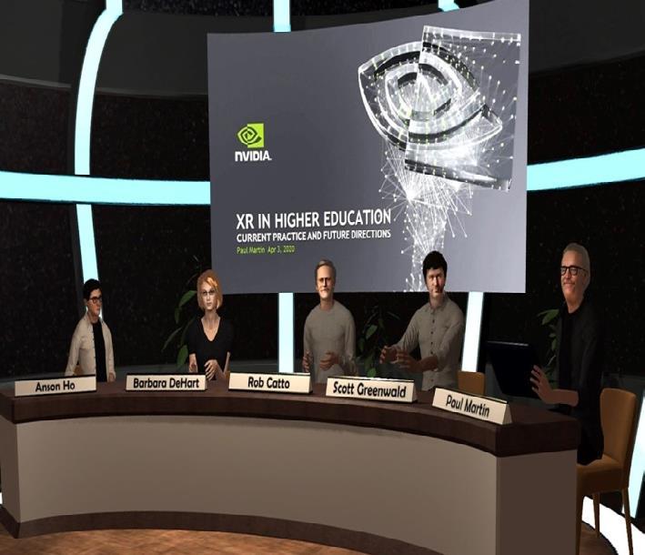
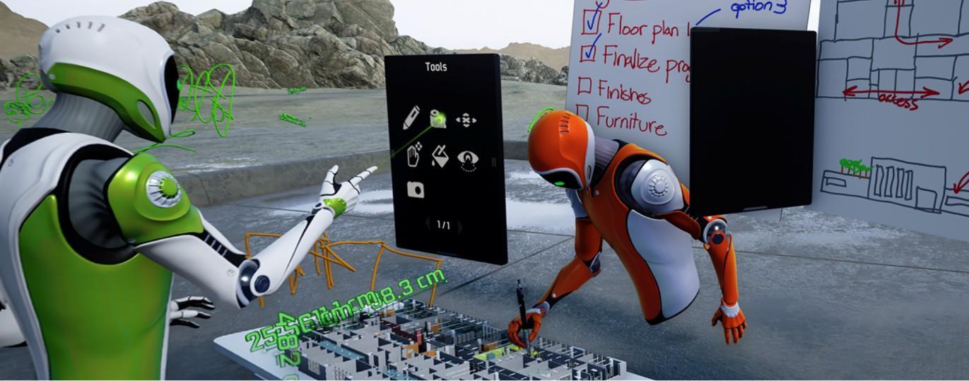
Virtual collaboration refers to the process of collaborating with team members who are geographically dispersed. VR empowers designers, peers, and stakeholders to collaborate in a 3D virtual environment and work on prototypes in a shared virtual space. An example of futuristic collaborative space is NVIDIA HOLODECK (Design & Professional Visusalization Solutions | NVIDIA, n.d.) which removes geographical barriers by providing photorealistic collaborative design in VR.

EASY AND NOVEL WAYS TO ENGAGE COMMUNITIES AROUND ROAD SAFETY La Trobe University, Centre for Technology Infusion 7
Figure 1: HoloDeck for collaboration in 3d virtual environment
Education and training
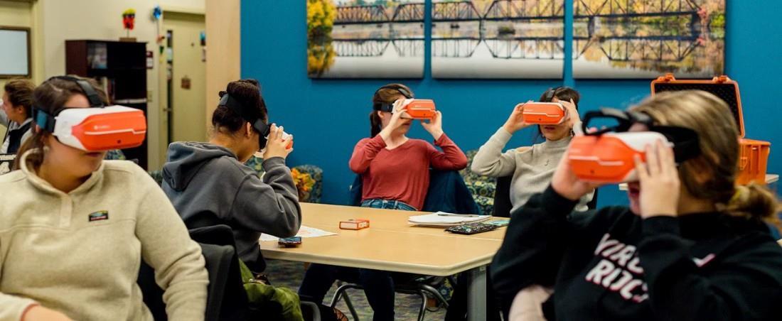
VR can offer risk-free training and interventions, enhancing the process of skill development by visualizing complex concepts in near-realistic virtual environments. It enables us to implement various road safety scenarios to enhance the skills of road users. An example of this is ClassVR (Virtual Reality in EducationClassVR, n.d.), which provides VR training solutions to educate drivers through diverse scenarios aimed at promoting safe driving practices. Australian Trucking Associations offers an interactive custom-built road safety exhibition that uses virtual reality and interactivemessaging all packed into a real travelling truck and trailer called SafeT360 3
Visualization of innovative design
With design visualization that is immersive and interactive, community members can gain a better understanding of plans and provide feedback on different design options, such as road alignments, intersections, and landscaping, before construction begins. This makes it easier to detect errors and faults early and prevent issues before the project commences. For example, Aecom provides visualisation and virtual reality solutions to communicate a design to clients, stakeholders, and the public in the most effective way possible (Visualisation and Virtual Reality, n.d.)
EASY AND NOVEL WAYS TO ENGAGE COMMUNITIES AROUND ROAD SAFETY La Trobe University, Centre for Technology Infusion 8
Figure 2: Integration of virtual collaboration into AutocAD (CannonDesign Accelerates VR Workflow by 150% Using 3ds Max, n.d.)
Figure3: The application ofVR in education(Virtual Reality in Education- ClassVR,n.d.)

Simulation
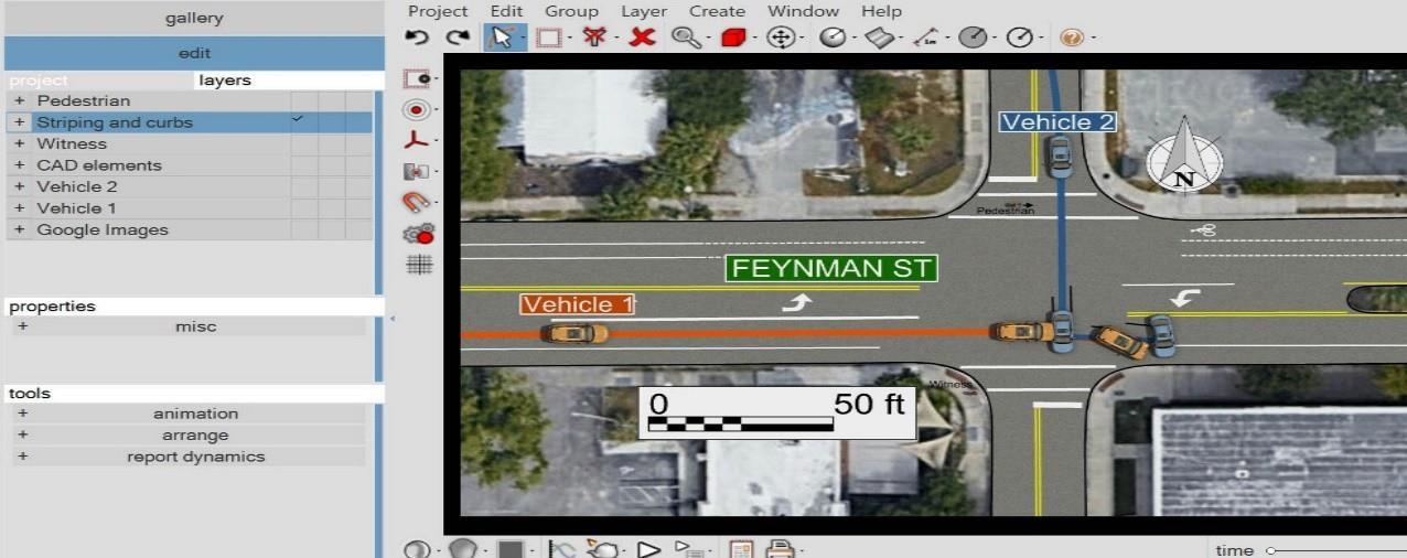
VR can be used to create realistic simulations of road events, such as road crashes, to allow stakeholders and community members to experience and understand the potential consequences of typical issues (e.g., a former design). For example, Virtual Crash Crashe Reconstruction Software (Virtual CRASH for Public Safety, n.d.) is a product for public safety professionals to quickly and easily generate scenarios and animations to address road safety issues. Also, VR simulation is suggested as a tool for understanding and evaluating pedestrian safety and perception at midblock crossings (Remote Control System for Heavy Machine by 3D VR |Virtual Reality Software(VR Software), Civil Engineering Software, BIM, Structure Design Software, Analysis Software, Simulation software|FORUM8, n.d.). By integrating augmented reality technology and advanced eyewear, such as smart goggles, users can visualize data overlays such as maps of their preferred route, speed metrics, and more. A notable application of this is RideOn Ski Goggles, which provide an intelligent navigation solution for traversing mountain slopes (RideOn Ski Goggles | The World’s First Smart Ski Goggles, n.d.)
EASY AND NOVEL WAYS TO ENGAGE COMMUNITIES AROUND ROAD SAFETY La Trobe University, Centre for Technology Infusion 9
Figure 4: The application of VR in Visualization (Visualisation and Virtual Reality, n.d.)
Figure 5: Virtual Crash: The application of VR in Simulation
AUGMENTED REALITY
Augmented reality (AR) is a technology that overlays visual, auditory, or other sensory information onto the real world, typically using a smartphone, tablet, or AR glasses.
Considerations
• AR is particularly useful to demonstrate or visualize new things in their intended, real environments.
• AR is potentially more accessible and easier to use than VR as it can be web based and supported by smart phones. This means that audiences can use their own phone. AR applications are usually less expensive to develop and implement than VR applications as existing devices and platforms can be used. AR enables the addition of contextual and interactive digital content to the physical surroundings. This means that the digital content in AR is anchored to the real world, so users can interact with it naturally.
• However, making AR projections blend into their surroundings realistically can still be a challenge because themore detailed and realistic 3D models are, the more data they require. Accurate placement of projected models in the real world can be another challenge, which in some cases require more sophisticated applications such as a 3D digital scan of the surroundings (which more and more councils have) or in-app placement techniques.
Example Applications
In-situ data visualization and gathering
AR facilitates the onsite visualization of information related to specific locations utilizing geolocation data. As detailed in (Pereira et al., 2024), AR provides users with information on historical landmarks in the city of Barcelos, allowing them to interact with and offer feedback on specific points. In the case of road safety, such an approach can be applicable to study and evaluate the experience of community members on the effectiveness of various road safety plans. InCitu isanother AR toolkit that engages residents in real-life, onsite, or remote transformation of real estate and planning datainto AR experiences It fosters collaboration around the process of urban change (inCitu | Home, n.d)
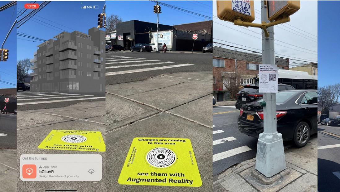
https://www.incitu.us/
EASY AND NOVEL WAYS TO ENGAGE COMMUNITIES AROUND ROAD SAFETY La Trobe University 10
Gamified education
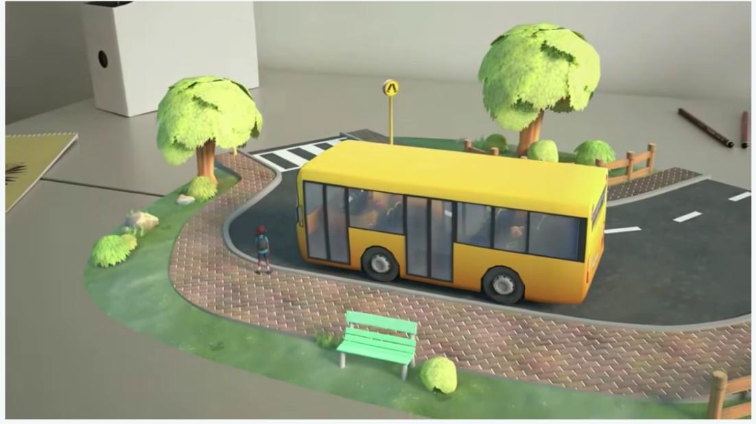
When integrated with gamification, AR/VR can improve the effectiveness of education on road safety. The experiment results in (Khan et al., 2021) show that gamification has a positive effect in improving the roadcrossing behaviour of children. Gamification is widely used in road safety education applications, including CreativiTek (CreativeTek,n.d.)and ARILITY (Arility - Augmented Reality Learning App, n.d.)
Remote collaboration
Remote collaboration can bridge the physical distance between individuals and create shared virtual spaces, aid communication, and provide access to real-time information and expertise. The Urban Co-Creation Data Lab project developed a simplified 3D modelling platform that integrates a web-based desktop, virtual reality, and mobile augmented reality technologies for remote simultaneous urban design collaboration (Imottesjo & Kain, 2022). The Lisbon Urban Co-Creation Data Lab platform provides smart management services, such as data preparation and open data infrastructure assessment, service analytics, future sustainability and project management for mobility, waste management, parking, pollution, and emergency response (UrbanCoCreationDataLab,n.d.) Furthermore, the University of Gothenburg developed an urban co-creation platform for remote collaboration and visualization which supports AR/VR technologies (Urban Co-Creation Lab | University of Gothenburg, 2022)

EASY AND NOVEL WAYS TO ENGAGE COMMUNITIES AROUND ROAD SAFETY La Trobe University 11
Figure 7: Urban-Cocreation by VR (Urban Co-Creation Lab | University of Gothenburg, 2022)
Figure 6: Gamification in AR ARILITY
Effective project communication and quality assurance
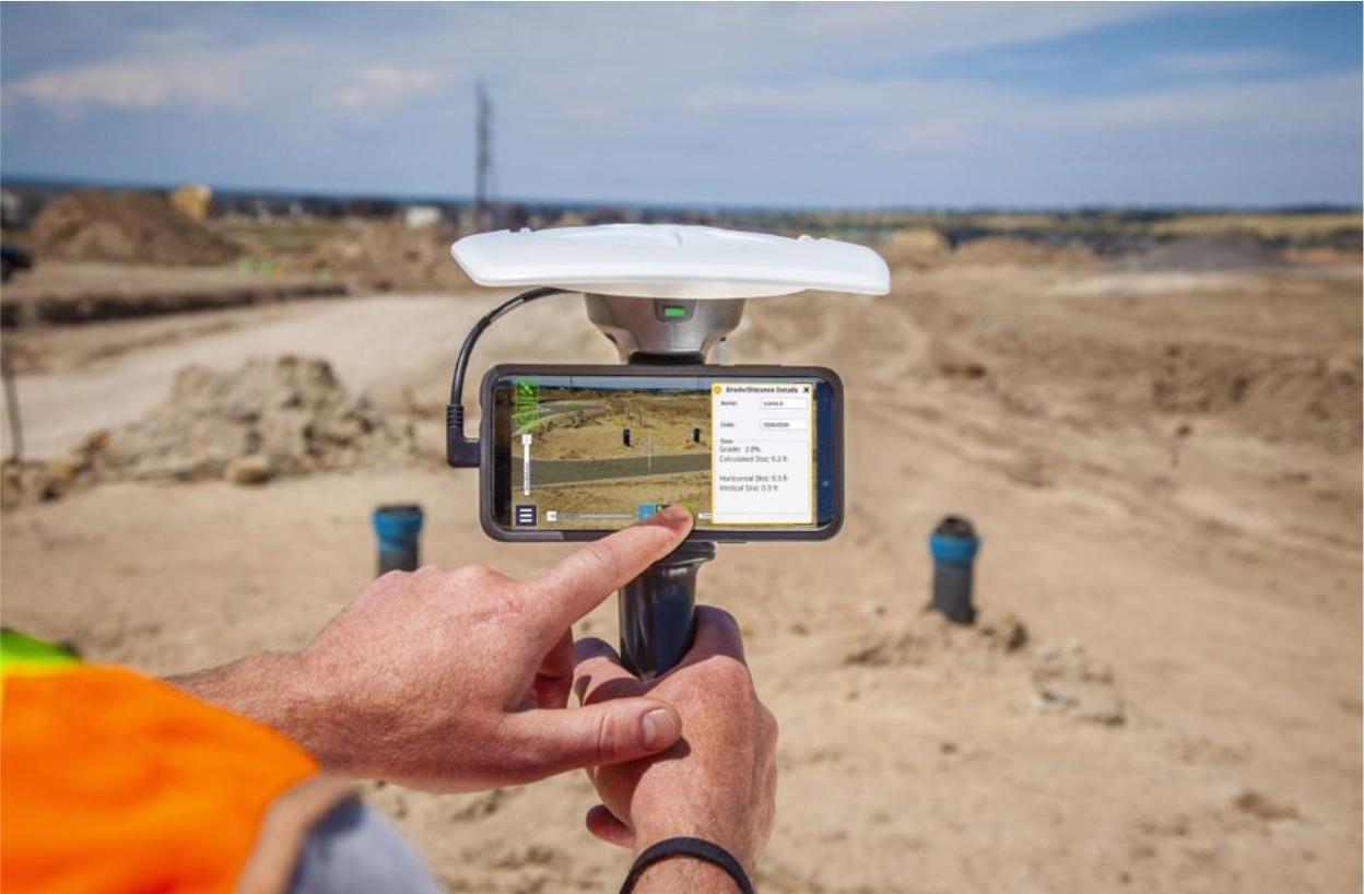
Project management and field operations encounter challenges such as the absence of real-time integrated information, disparities between planned strategies and their execution, insufficient quality assurance standards and ineffective communication within projects. Augmented reality/mixed reality (AR/MR) has the potential to overcome these challenges by overlaying immersive digital content, such as 3D construction models, onto the real world. As an example, the United States Department of Transportation recommended the use of augmented reality in highway construction to enhance construction inspection, quality assurance, worker safety, and overall project management (Gilson et al., 2020)
EASY AND NOVEL WAYS TO ENGAGE COMMUNITIES AROUND ROAD SAFETY La Trobe University 12
Figure 8: Leveraging AR for road construction.
MIXED REALITY
Mixed reality (MR) combines elements of both AR and VR to anchor virtual objects to the real world and to allow its users to interact with physical or virtual objects. It provides a high level of immersion by integrating digital content into the user’s environment and it also allows for interaction with both the physical and virtual worlds. It can be used for applications that blend physical and digital interactions, such as collaborative work, training simulations, and design visualization.
Considerations
• MR technology often requires specialized hardware like HoloLens, which can be expensive.
• MR technology is generally more expensive than AR and VR, as it requires advanced hardware, such asspecialized headsets that can track the user’s position and communication modes in real time.
• MR technology requires specialized content that can be challenging to develop and may require expertisein 3D modelling and programming, however, cost and complexity are decreasing rapidly over time.
Example applications
User Behaviour Study
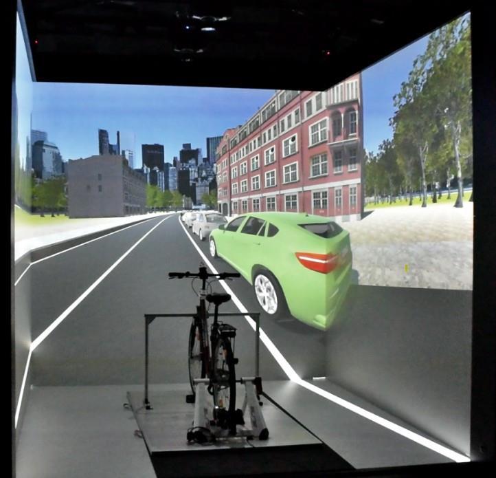
MR technology can be highly effective for studying and analysing road users' behaviour due to its ability to provide an immersive and realistic experience, facilitate a safe environment, and enable easy data collection. An example of its application can be seen in the work of the Australian College of Road Safety (gene@pbwebdev.com.au, n.d.), which utilized a co-design approach to develop the Hector VR® MR driving simulator. This simulator was specifically designed to capture and analyse information regarding the driving competence of older drivers, including their reaction time and adherence to road rules. Furthermore, in (Skjermo et al., 2022), a combination of VR and eye tracking technology is proposed to evaluate road safety education in different scenarios.
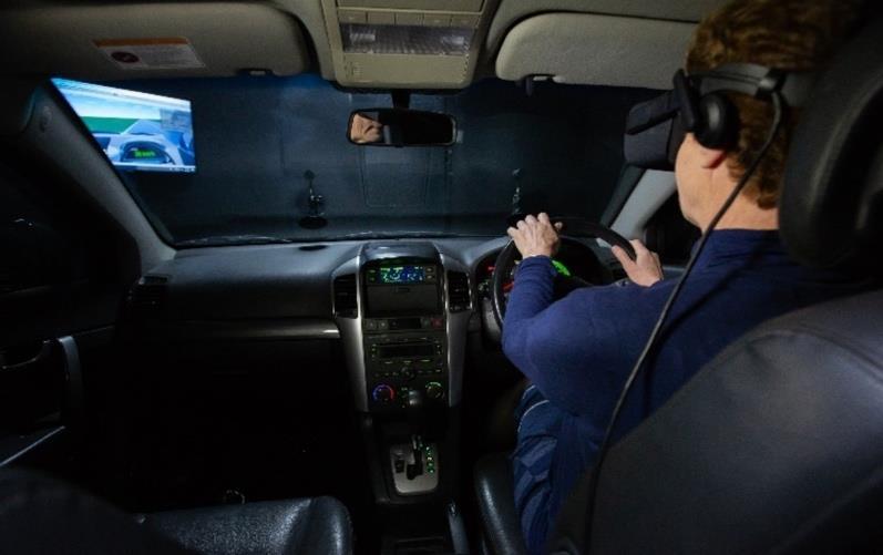
(gene@pbwebdev.com.au, n.d.)
EASY AND NOVEL WAYS TO ENGAGE COMMUNITIES AROUND ROAD SAFETY La Trobe University, Centre for Technology Infusion 13
Figure 9: Driving simulator
Participatory planning and design
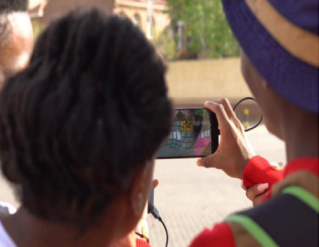
Another implementation area for mixed reality is participatory planning and design, which plays a pivotal in tailoring the development of projects to reflect the community’s needs. By leveraging MR, communication in design and planning is enhanced, enabling stakeholders and citizens to articulate and understand diverse perspectives more effectively. An exemplar of this approach is a pilot project implemented by ERICSON in Johannesburg, South Africa, which highlights the potential of MR to facilitate public involvement in designing sustainable urban and public spaces (Mixed Reality for Public Participation in Urban and Public Space DesignTowards a New Way of Crowdsourcing More Inclusive Smart Cities | UN-Habitat, n.d.)
Prototyping and implementation of ideas
Advanced Simulations
MR allows for advanced simulations by seamlessly combining the strengths of real and virtual domains where physical and digital components coexist and interact in real time. MR enables the overlay of interactive 3D models onto real-world scenarios, supports multi-user collaboration, tracks user interaction, and provides immediate feedback through the integration of diverse sensors and devices. In (von Sawitzky et al., 2022), MR is suggested as a technology support for the next stage of roadtrafficeducation bydevelopinga mixed reality bicycle simulatorto improve cyclist safety.
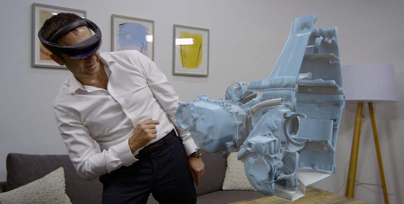
By taking advantage of CAD data, engineers can utilise MR to interact with and modify 3D digital models before the actual components are produced. This capability adds significant value, allowing simulations and reproductions to be developed in a controlled, standardized environment, mitigating situations that would traditionally be expensive, complex, or dangerous. As an example, the Airbus Holographic Academies, in partnership with Microsoft’s Mixed Reality Program, are taking advantage of MR to pioneer advanced prototyping and implementing promising ideas (Thompson, n.d.)
EASY AND NOVEL WAYS TO ENGAGE COMMUNITIES AROUND ROAD SAFETY
Technology Infusion 14
La Trobe University, Centre
for
Figure 10: Mixed reality for public participation
Figure 1: Hazard notification system for cyclists, (von Sawitzky et al., 2022)
EASY AND NOVEL WAYS TO ENGAGE COMMUNITIES AROUND ROAD SAFETY
La Trobe University, Centre for Technology Infusion
Figure 2: The application of VR in design(Virtual Reality with Real Benefits | Airbus, 2021)
GEOGRAPHIC INFORMATION SYSTEMS(GIS)
A GIS is an information system that collects, stores, manipulates, analyses, manages, and presents spatial or geographically referenced data, often in a map format.
Considerations
• GIS can be particularly useful when the same situations (e.g., crashes or average car speeds) can be collected, counted and/or presented in a map
• GIS data can sometimes be sensitive, especially when it relates to individuals’ private information. The platform should prioritize data privacy and security, given that users access it through the Internet.
• Not everyone is a GIS expert. If the system is intended for use by a broader audience, it is important to consider the general usability of the user interface and the system.
• GIS data and software need to be compatible with other systems, which may involve working with different data formats and standards. It is important to ensure that the service is compatible with the organization’s existing operating systems, infrastructure, and data formats.
• The quality of GIS analysis is heavily dependent on the accuracy of the data. Error, inaccuracy, and imprecision can affect the quality of analysis and decision-making in mobile GIS.

Figure 13: Hotspot visualization using ArcGIS in (Where Are the Best Stops and Routes for a Bookmobile? Analytics | Dokumentation, n.d.),
EASY AND NOVEL WAYS TO ENGAGE COMMUNITIES AROUND ROAD SAFETY La Trobe University 16
Example Applications
Hotspot Visualization
Visualizing information about areas of interest, such as areas with high crash rates, offers communities a clear insight into the problem. GIS hotspot visualization enables the road safety community to monitor events, understand and prioritize actions, and share experiences transparently, making them accessible to all. For instance, in (Where Are the Best Stops and Routes for a Bookmobile? Analytics | Dokumentation, n.d.), the ArcGIS Desktop is utilized to determine the optimal locations for the stops of a bookmobile and the most efficient routes between them. This involves a Location-Allocation analysis to pinpoint stops to optimize attendance, and the geoprocessing tool to devise the best routes and schedules.
Collecting community feedback
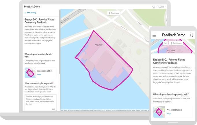
Collecting feedback from the public enables local officials to understand the challenges facing the community more comprehensively. The geographical component is a crucial aspect of public projects which helps in understanding thedynamics between people and places. GIS helps to conduct map-focused surveys. For example, ArcGIS Hub includes map-focused survey design facilities that allow the public to input geographic data using mobile responsive maps (Thompson, n.d.)
Spatio-temporal analysis
GIS is a powerful tool for conducting spatiotemporal analyses. In the context of road safety, these analyses in dimensions of time and space can offer insights into traffic patterns, hotspots, temporal trends, and future trends for planning. An example of this is the application of In the central-eastern section of Qatar, GIS-based spatio-temporal analysis isbeing used to identify hotspot road crash areas (GIS-Based Spatiotemporal Analysis for Road Traffic Accidents; in Support of Sustainable Transportation PlanningScienceDirect, n.d.) Moreover, the work in (Harirforoush, 2017) proposed different methods to identify and rank hotspot locations, both in situations where the traffic volume is available and those where it is not.
EASY AND NOVEL WAYS TO ENGAGE COMMUNITIES AROUND ROAD SAFETY La Trobe University 17
Figure 3: GIS based feedback collection maps (Thompson, n.d.).
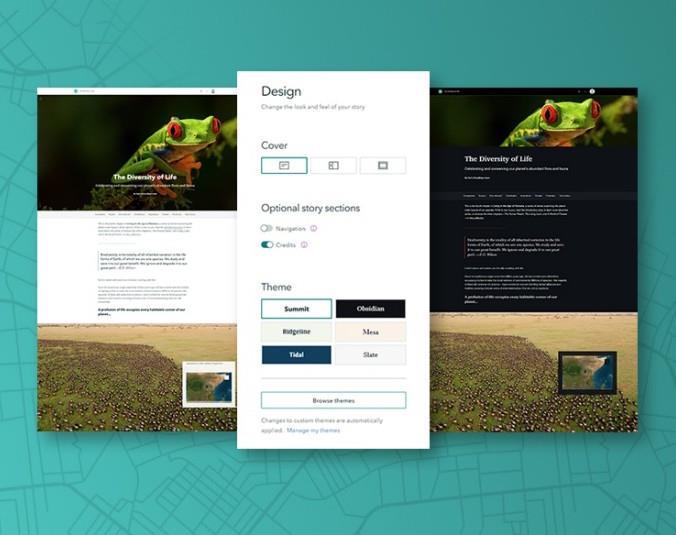
Figure 15: GIS based story maps (ArcGIS StoryMaps, n.d.)
Story Maps
Telling a story with maps using the capabilities of GIS systems is an effective way to convey information, interpret spatial data, and simplify complex topics into engaging and comprehensible narratives. It transforms data from a GIS into interactive content that can educate, motivate, and involve stakeholders. UC Berkeley introduced a community engagement tool which allowed residents, community groups, and agencies to record details about transportation incidents, near-misses, hazards, and safe travel paths (Medury et al., 2019). Similarly, Esri’s ArcGIS StoryMaps tool transforms GIS outputs into interactive narratives that inform, inspire, and captivate stakeholders (ArcGIS StoryMaps, n.d.)
GIS Safety Campaigns
GIS can help in the planning and implementation of community campaigns. In the context of road safety, targeted campaigns can be designed by identifying the most affected demographics. Vision Zero Washington DC’s website provides aneducational section highlighting campaigns that promote safer driving and pedestrian practices across the district created with ArcGIS StoryMaps technology (Education, n.d.)
Geospatial Social Media
Location-based social media provides a source of data to enhance public safety, healthcare, education, and can also help non-profit organisations increase their exposure and reach a wider audience. Esri initiated startups to fuse communication media with GIS. Startup Echosec Systems developed a location-based search platform that allows public safety organizations, security firms, journalists, and intelligence professionals to analyse information on social media and turn it into actionable knowledge (“Esri Startups Fuse Communication Media with GIS,” 2019). In the researchin (Salazar-Carrilloetal.,2021), geocodetrafficrelated events collected from Twitter are used to describe the traffic behaviour of specific areas in Mexico City.
EASY AND NOVEL WAYS TO ENGAGE COMMUNITIES AROUND ROAD SAFETY La Trobe University 18
ARTIFICIAL INTELLIGENCE
Artificial intelligence (AI) leverages computers and machine learning to perform tasks that require humanlike intelligence, such as decision-making, language understanding, and pattern recognition.
Considerations
• AI enables a more customized interactions, which can improve engagement efforts.
• A form of AI is already used countrywide in traffic light and traffic form optimization
• An accurate AI-system needs to be trained on a large amount of real-world data, which may include personalinformation of drivers and passengers. These data need to be handled with care, secured properly, and not misused.
• Generative AI can sometimes be considered a black-box system as it can be challenging to comprehend and trust. To ensure the decisions which have been made by AI are trustworthy, particularly in safety-critical domains like road safety, it is essential to understand the reasoning behind an AI model’s decision-making. Hence, there is a need for eXplainable AI (XAI) methods to improve trust in AI models, particularly in critical road safety applications.
• AI systems learn from data. If the data used to train these systems contain bias, the AI system is likely to learn and reproduce these biases. This can happen due to historical inequalities, nonrepresentative samples, or biased labelling, among other reasons.
Example Applications
Generative AI (GAI)
GAI is a type of AI that can generate new forms of creative content such as text, images, or audio, based on patterns and data learned from existing examples. Technology is becoming more conversational and intuitive. With the advancements in language models such as GPT-4, conversational interfaces are able to understand and respond to human language more naturally and intelligently. It has revolutionized AI-based textual conversation systems and paved the way for the development of multi-modal conversational systems. As a result, conversational systems will beapplied beyond textual conversations to 3D modelling, virtual environment generation, and video generation (This Guy Built a Robot to Write New Episodes of Friends, n.d.).
Conversational AI: Human listening
Conversational AI is a set of machine learning (ML) technologies, including Natural Language Processing, that enables human-like interactions between users and computers. In market research, for example by research agency Evolved, conversational AI is used to replace or augment traditional surveys, allowing respondents to engage with an inquisitive feedback companion using two-way conversation. ‘Frankly’, an AI-powered platform designed to facilitate multi-channel engagement between customers, online communities, and staff, can offer a robust platform to collect and analyse an extensive volume of unprocessed data, particularly in the form of community opinions and feedback. It efficiently compiles and presents its findings with an impartial perspective, driven by AI (Home, n.d.).
EASY AND NOVEL WAYS TO ENGAGE COMMUNITIES AROUND ROAD SAFETY La Trobe University, Centre for Technology Infusion 19
Customized chatbots
Community engagement chatbots engage community members in two-way conversations. They can capture and process data and give insights for informed decision-making. SocialCauses, a social tech company established in 2020, offers solutions for improved communication and engagement of community members at scale (Community Engagement Chatbot, n.d.).
Identification and recognition
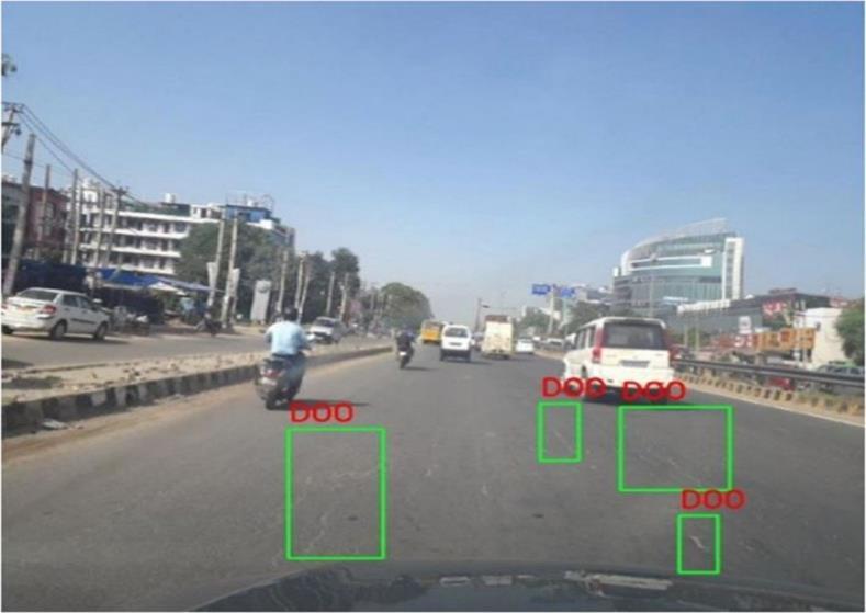
Deep learning models, especially convolutional neural networks, can process vast amounts of visual data from cameras mounted on vehicles, drones, or roadside infrastructure. These models can identify road conditions, traffic congestion, crashes, or any unusual activities on the roads. The work in (Deepa & Sivasangari, 2022) proposes a hybrid deep learning framework for detecting and classifying road damage images. The method involves preprocessing images for enhanced contrast, segmenting damages, clustering, extracting features, reducing dimensionality, and classifying damages.
Predictive analytics
AI can help to assess road crash risks at scale. This can help reduce the consequences of dangerous roads around the world. Omdena, a community-driven organisation which offers a collaborative platform to build innovative, ethical, and efficient AI and Data Science solutions to real-world problems, collaborated with The International Road Assessment Programme (iRAP) to work towards iRAP’s vision of “a world free of high-risk roads”. The project utilized AI techniques to introduce a pipeline to rate more than 100 million km of road worldwide by sourcing the crucial component of vehicle count under the traffic or vehicle flow attribute using satellite imageries with the help of AI (Khan et al., 2021)
Traffic scenario generation
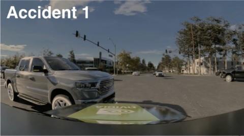
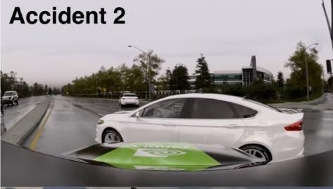
Assessing and enhancing plans for autonomous vehicles necessitates the scalable creation of unique traffic situations. These scenarios should be authentic and demanding yet safely navigable. AI can help to generate useful crash-prone driving scenarios. STRIVE is a method to automatically generate challenging scenarios that cause a given planner to produce undesirable behaviour such as collisions (Generating AI-Based Potential Accident Scenarios for Autonomous Vehicles | NVIDIA Technical Blog, n.d.)
EASY AND NOVEL WAYS TO ENGAGE COMMUNITIES AROUND ROAD SAFETY La Trobe University, Centre for Technology Infusion 20
Figure 16: TactGlove haptic gloves designed for AR/VR technology [14]Image8251.PNG
Post-incident data analytics
AI provides powerful analytical solutions for post-incident data analysis. For example, natural language processing algorithms can help to extract knowledge from road incidents reports with the objective of identifying the factors influencing road safety (Valcamonico et al., 2021) the rate of accidents with severe and fatal consequences is still exceeding the safety objectives (European Commission 2019; World Health Organization 2018.

Computer-generated imagery
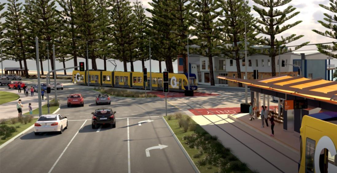
Computer generated imagery can be used to promote road safety and enhance community engagement. It can be used for the visualization of potential hazards and the interactive simulation of infrastructures. UrbanCGI provides a platform for the simulation of projects. It allows scenarios to be easily planned and managed, which can improve the level of engagement of community users (Urban CGI – Digital Twin Technology Company, n.d.). Also, CARLA is an open-source simulator for autonomous driving research. It provides open digital assets (urban layouts, buildings, vehicles) to support the flexible specification of sensor suites, environmental conditions, the full control of all static and dynamic actors, map generation and much more (Team, n.d.)
EASY AND NOVEL WAYS TO ENGAGE COMMUNITIES AROUND ROAD SAFETY La Trobe University, Centre for Technology Infusion 21
Figure 17: Generating AI-based potential crash scenarios (Generating AI-Based Potential Crash Scenarios for Autonomous Vehicles | NVIDIA Technical Blog, n.d.)
Figure 18: Urban digital twins (Urban CGI – Digital Twin Technology Company, n.d.)

Identifying risky behaviour
AI can simulate road users' behaviours. Specifically, deep learning algorithms can recognize, predict, and reduce risky behaviours by offering real-time alerts and facilitating prompt intervention. For example, in (Hasan et al., 2023), a vision-based algorithm is used to recognize driver activity to identify distracted driver behaviour from safe driving behaviour. Gypsee Drive Safe is an AI-powered mobile app that uses algorithms from generative AI to track driving behaviour and give instant feedback. By evaluating data on acceleration, braking, and speeding, it offers tailored coaching for better driving (Fleet Fuel Card With Rewards | Boost Fleet Driver Performance & RetentionMilesmate, n.d.).
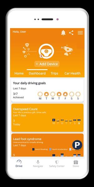
Figure 20:AI-powered mobile appfor tracking driver’s behaviour
EASY AND NOVEL WAYS TO ENGAGE COMMUNITIES AROUND ROAD SAFETY La Trobe University 22
Figure 19: Traffic simulation using Unreal Engine and CARLA (CARLA Democratizes Autonomous Vehicle R&D with Free Open-Source Simulator, n.d.)
WEB PLATFORMS
Web platforms, such as online forums, discussion boards, crowd-sourcing platforms, and polling tools, are dynamic community spaces on which community members can discuss and collaborate on different topics/issues related to the community. It allows people to start new discussion threads or reply to existing threads to interact with other members of the community.
Considerations
• Web platforms can create efficiencies as they standardize feedback, can process and summarize feedback andif required allow for very large groups to interact with the system.
• The community should demonstrate the clear value of joining forums to motivate community members to participate in discussions actively.
• The community should have a policy on collecting feedback from members in terms of whether a member’s expectations had been met.
• The community should establish clear guidelines for participation, including rules for respectful communication and behaviour.
• Forums should have moderators, for example, to use engagement tactics with engagement purposes.Online forums should encourage transparency and accountability by providing a clear picture of projects for stakeholders.
Example applications
Collecting feedback
Web platforms and discussion boards facilitate the collection of feedback. For example, they enable communities to announce their concerns and experiences about road safety. Such feedback is crucial for local authorities to pinpoint problem areas. Participate Melbourne is an online hub for the City of Melbourne which enables individuals to contribute their perspectives on urgent matters and upcoming initiatives. For instance, on 11 April 2023, public input was sought to prioritize proposed pedestrian improvement projects (Improving Walkability and Road Safety in South Yarra, n.d.) CitizenLab is a webbased community engagement platform for local governments that uses gamification to shape effective digital citizen participation (Ransbeeck, 2016).
Behaviour analysis
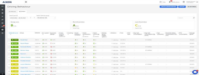
Web-based applications can be used to monitor and analyse road users’ behaviours. For example, AXXON is a company which offers management solutions to enable companies to monitor and oversee their vehicles. They have developed a system which gamifies driver behaviour to incentivize drivers to adopt safer behaviours, increase compliance, improve their skills, and increase engagement and motivation using various elements, such as displaying driver performance on leaderboards, setting clear, measurable goals for drivers, and rewarding those who meet or surpass the company’s objectives (Start Gamifying Your Driver’s Behavior Today!, n.d.)
EASY AND NOVEL WAYS TO ENGAGE COMMUNITIES AROUND ROAD SAFETY La Trobe University, Centre for Technology Infusion 23
Crowd-sourced data collection
The emergence of cloud-based computing has revolutionized methods of data collection and data storage. With the ability to store and process data on remote servers accessed through the internet, cloud-based solutions offer a cost- effective and efficient way of collecting and storing data from various sources and locations. For example, Amazon Mechanical Turk (MTurk) is a crowdsourcing marketplace that makes it easier for individuals and businesses to outsource their processes (Amazon Mechanical Turk, n.d.)
Cloud-based data analysis
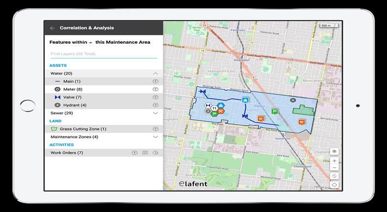
Organizations and businesses depend on operational information to shape decisions, make strategies, execute tasks, and cater to customer needs. Cloud platforms provide intuitive and easy to use data analysis and visualization for all types of businesses. These platforms offer scalability, flexibility, and economical avenues to manage and showcase extensive datasets. One notable example is the Elafent cloud platform, a professional multiplatform solution designed to collect, connect, and communicate operational data in a dynamic way. Elafent empowers users to effortlessly manage and transform high volumes of rapidly changing data into meaningful information ready to users to consume and action to extract insights and make intelligent datadriven business decisions (Elafent, n.d.).
EASY AND NOVEL WAYS TO ENGAGE COMMUNITIES AROUND ROAD SAFETY La Trobe University, Centre for Technology Infusion 24
Figure 21: AXXON fleet gamifying driving behavior
Figure 22: Cloud based data analysis and processing (Elafent, n.d.)
INTERACTIVE DIGITAL SIGNAGE
Interactive digital signage involves the use of screens, projectors, and other digital displays to deliver messages and information to an audience and allows users to interact with the content using touch or gesture-based input. Digital signs are typically used in public spaces, such as airports, shopping centres, museums, or corporate lobbies, to provide information, promote products or services, or engage with customers or visitors.
Considerations
• Interactive digital signage has the benefit of alerting and engaging community members ‘in situ.’
• It is important to bear inmind that the content plays animportant role in the effectiveness of signage displays. Therefore, a brief, effective and impactful message using dynamic content such as animations and videos is more engaging and captures the attention of the audience more effectively than traditional static signage.
• It is also important to consider the location, time and size of the signage which have a direct impact on the effectiveness of community engagement.
Example applications
Public displays
Public displays can enhance community engagement in urban areas, creating engaging experiences by presenting information and gathering public feedback. The work in (Hespanholetal., 2015) proposed a vote-as-you-go polling system to collect public feedback using a web application on an iPad or via a playful full-body interaction interface (Just Digital Signage Is a Leading Provider and Innovator of Digital Signage Solutions, 2022)

EASY AND NOVEL WAYS TO ENGAGE COMMUNITIES AROUND ROAD SAFETY La Trobe University, Centre for Technology Infusion 25
Figure 4: City displays for public feedback collection (Hespanhol et al., 2015)
Interactive kiosk
The digital signage solution offers on-demand information in busy public spaces. Its interactive screens display a variety of information, ranging from wayfinding and event specifics to real-time transportation schedules and other external content. Just Digital Signage, a provider and innovator of digital signage solutions, delivers these digital signage solutions throughout Australia (Just Digital Signage Is a Leading Provider and Innovator of Digital Signage Solutions, 2022).

EASY AND NOVEL WAYS TO ENGAGE COMMUNITIES AROUND ROAD SAFETY La Trobe University, Centre for Technology Infusion 26
Figure 24: Digital signage for community engagement (Just Digital Signage Is a Leading Provider and Innovator of Digital Signage Solutions, 2022)
DIGITAL TWINS
A digital twin is a dynamic virtual representation of a real-world state, behaviour, or environment. It facilitates simulations and evaluations across varied scenarios, providing crucial insights for real-world planning and monitoring.
Considerations
• Digital Twins can provide modelling, visualization and many other benefits that can be used in community engagement.
• Due to data dependency, digital twins may raise a range of ethical concerns, such as the potential for biasedalgorithms or unintended consequences.
• To support the scalability of a digital twin, it is important to use data and communication standards that promote interoperability and allow the data to be shared and used more easily across different systems andplatforms.
• Cloudservices allows for greater scalability, flexibility, and cost-effectiveness. However,there are also concerns around security, privacy, and data ownership when using cloud-based solutions.
• Digital twins can be targeted by cybercriminals due to the presence of sensitive and confidential data, whichcan be exploited for industrial espionage or to manipulate the physical system that the digital twin represents. Such unauthorized access poses a security threat to digital twins.
Example Applications
Digital Pedestrian Human Twins
This refers to replicating human behaviour (e.g., pedestrian movement, driver behaviour, and interactions) to understand the potential risks due to human factors. This research is in its very initial stages. In (Wang et al., 2023), a digital twin framework is proposed to support the relation between connected vehicles, pedestrians and the traffic environment and was used to investigate the potential of digital twins in implementing a vehicle- pedestrian warning system.

EASY AND NOVEL WAYS TO ENGAGE COMMUNITIES AROUND ROAD SAFETY La Trobe University, Centre for Technology Infusion 27
Figure 25: Digital twins’ simulator for pedestrian connection with vehicles (Wang et al., 2023)
Traffic flow Digital Twins
Traffic flow digital twins enable the traffic system to use past and present information to predict traffic conditions, facilitating more effective optimization for autonomous driving and intelligent transportation systems. The work in (Li & Zhang, 2023) integrates the Internet of Vehicles (IoV) with sensor data from mainstream traffic sensors based on radar and camera fusion to construct an end-to-end digital twin system that builds a digital twin (DT) model of trafficflow. Also, MOREAI Inc., a South Korean technology company that develops simulation platforms to verify the safety and reliability of autonomous vehicles, has developed a digital twin environment which enables the 3D-based real- time monitoring of virtual traffic flow (Traffic | MORAI Inc., n.d.)

Virtual replication of infrastructures and services
Replicating infrastructures and services virtually involves representing the physical layout of infrastructures and services as a 3D virtual replica, enabling visual inspections, basic simulations, and preliminary planning. An example of this type of digital twin is Virtual Singapore, which offers a 3D digital reflection of Singapore city, supported by real- time data, to simulate and test novel solutions for urban planning challenges (Virtual Singapore, n.d.)

EASY AND NOVEL WAYS TO ENGAGE COMMUNITIES AROUND ROAD SAFETY La Trobe University, Centre for Technology Infusion 28
Figure26:MorAI traffic simulator
Figure 27: Virtual Singapore, 3D virtual replication of Singapore
Planning and decision making
Digital twins enable the visualization of unbuilt infrastructure and properties in a realistic city model. These features offer the potential to communicate future projects and to visualize how they integrate within an existing built landscape. The Wellington City digital twins use live city data to generate an interactive, largescale city model with integrated data. The real-time data provides transportation statistics for bus, rail, ferry, bike, and car traffic, as well as air traffic visualization and car park availability (Wellington Digital Twin | Buildmedia, n.d.)

n.d.).
Life cycle management
Digital twins enable the smart monitoring of assets and products, capturing real-time data and applying data-driven analysis to predict potential weak points or overloads. This can help to mitigate damage and assist in planning for an efficient recovery. Google has registered a patent for monitoring and controlling remote devices (US7468661B2System and Method for Monitoring and Controlling Remote Devices - Google Patents, n.d.)
Environmental digital twins
GIS can be used to create environmental digital twins which enables the current state of an ecosystem to be captured and for predictions to be made about how it will change. The Nature Conservancy is taking a digital twin approach to document the uniqueness of the Jack and Laura Dangermond Preserve, to guide its careful protection and restoration (Hamann & Peek-Asa, 2017)�
EASY AND NOVEL WAYS TO ENGAGE COMMUNITIES AROUND ROAD SAFETY La Trobe University, Centre for Technology Infusion 29
Figure 28: Wellington City digital twins use live city data to generate an interactive 3D replica (Wellington Digital Twin | Buildmedia,
WEARABLES AND SMARTPHONES
Wearable technology refers to electronic devices that are specifically designed to be worn as accessories, embedded in clothing, implanted in the user’s body, or even tattooed on the skin. These devices are handsfree and typically contain microprocessors which can send and receiving data via the Internet. Wearable technology has many practical uses andcan provide users with unique benefits and experiences.
Considerations
• Wearables are only effective if users are engaged and motivated to use them, which may require communitiesto encourage members to share their wearable data.
• Wearables may give rise to data privacy and security concerns, as communication is typically conducted over the Internet. To adhere to ethical regulations, the use of wearables should be transparent, and the potentialbenefits and risks should be clearly communicated to participants.
• Wearables can be expensive, which may limit their accessibility to members of a community. It is important to consider how to make wearables affordable and accessible to all members of the community, regardless oftheir financial situation.
• Wearables generate raw data. To effectively utilize wearable data to gain community insights, it is necessaryto conduct data analysis and processing on the raw data.
Example Applications
Data collection
Community members can use wearables, such as GPS-enabled video cameras mounted on helmets, to collect data on their travel patterns. This helps traffic planners better understand the routes and behaviour of road users. This data can guide the development of safer and more efficient traffic plans. In (Ameddah et al., 2018), a cloud-based real-time road condition monitoring system was proposed to identify road hazards and defects using a smartphone accelerometer. The experiment results showed that by using machine learning techniques, the model can classify road conditions with high accuracy (88.67%). A GPS-enabled video camera mounted on a helmet was used to examine therates and characteristics of safety-relevant events (crashes,nearcrashes,errors, andtraffic violations) involving adult and child bicyclists. In (Innovator | 2020 | Jan/Feb, n.d.), big data, sensors, social media, and GIS were employed to identify road crash locations. In (RiskSens: A Multi-View Learning Approach to Identifying Risky Traffic Locations in Intelligent Transportation Systems Using Social and Remote Sensing | IEEE ConferencePublication | IEEE Xplore, n.d.), traffic-related social media content (e.g., tweets) was linked with GIS to identify crash hotspots in New York City with an accuracy which was 8.1% higher than the methods based on the police department database.
Promoting safe behaviour
Wearable devices can monitor drivers’ vital signs and eye movements to detect drowsiness, alerting them when it is time to take a break, thereby reducing the risk of the driver falling asleep at the wheel. For example, FEELythm is a wearable sensor that promotes safer driving by detecting when the driver is drowsy. It uses a sensor attached to the earlobe, gauges drowsiness based on this data, and notifies both the driver and their vehicle fleet manager (Fujitsu Launches FEELythm, a Wearable Sensor That Promotes Safer Driving - Fujitsu Global, n.d.)
EASY AND NOVEL WAYS TO ENGAGE COMMUNITIES AROUND ROAD SAFETY La Trobe University, Centre for Technology Infusion 30

Figure 29: FEELythm, a wearable sensor that promotes safer driving by detecting when the driver is drowsy (Fujitsu Launches FEELythm, a Wearable Sensor That Promotes Safer Driving - Fujitsu Global, n.d.)
Push notifications
Push notifications on wearable devices or smartphones can be used to notify community members about, for example, an upcoming event. Emergency Mass Notification System (EMNS) platforms provide a valuable solution for safety and incident prevention strategies. For instance, the LiveSafe Mobile App enables employees, students, and workers to quickly submit information directly to security, access important safety and security resources, and receive critical information. This allows people to contribute to the safety and security of an organization (Vector LiveSafe: Emergency & Safety Communications App, n.d.)
EASY AND NOVEL WAYS TO ENGAGE COMMUNITIES AROUND ROAD SAFETY La Trobe University, Centre for Technology Infusion 31
SPATIAL AUDIO TECHNOLOGY
Spatial audio technology creates a three-dimensional sound environment, simulating the way sound behaves in a physical space. It allows listeners to perceive the origin points of different sounds as if they are enveloping them from all directions. It provides a more immersive listening experience.
Considerations
• Spatial audio may give rise to ethical concerns as it has the potential to produce emotional reactions in users, which could have unintended consequences.
• Spatial audio technology may require specialized hardware, software, and production expertise, which can result in substantial costs.
Example Applications
Safe and efficient navigation
Real-time 3D spatial audio technology can be utilized to promote safe and efficient navigation. In (Schwartz&Bell,2023), a platform is proposed that leverages advanced 3D scanning technology integrated with mobile devices to digitally construct a live 3D map of a user’s surroundings as they navigate through a space. The primary goal of thisproject is to assist individuals with vision impairments, enabling them tonavigate and understand spaces safely, efficiently, and independently.

EASY AND NOVEL WAYS TO ENGAGE COMMUNITIES AROUND ROAD SAFETY La Trobe University, Centre for Technology Infusion 32
Figure 30: Push notifications using Vector livesafe application
INTERNET OF THINGS (IOT)
The InternetofThings refers tothebillionsof physicaldevicesaroundtheworldthat are nowconnectedtothe internet, all collecting and sharing data.
Considerations
• IoT devices collect and transmit data, potentially including personal information. It is important to ensure that robust policies for data security and privacy are in place in IoT services design.
• It is crucial to ensure that there is seamless connectivity and data flow between devices, the infrastructure, the cloud, and applications with any IoT-enabled device.
• If an IoT device malfunctions or causes damage, the manufacturer could be held liable. Proper testing,certification, and compliance with safety standards can help minimize liability risks.
Example Applications
Road condition monitoring
IoT sensors can be placed on roads to monitor conditions and communicate this information in real time to drivers via mobile apps and road signs, as well as to local authorities for a swift response. Transport for NSW is partnering with Ciscotoconduct a seriesoftrialsutilizingIoT technology to reduce congestion andimprove connected, safer journeys for the community. For instance, TfNSW is experimenting with IoT edge computing to gain real-time insights into public transport performance, which aims to enhance customer and operator service (Transport for NSW, n.d.)
Vehicle to everything (V2X) communication
V2X will in the future (at least 5 – 10 years) allow vehicles to communicate with each other and with infrastructure such as traffic lights, signs, and pedestrian crosswalks through automotive IoT technology. This can help prevent crashes by alerting drivers to potential hazards, like a car braking suddenly up ahead or a pedestrian entering a crosswalk. BEC offers all-in-one solutions tailored for transportation operations to support the full range of connectivity needs, enabling a wide range of road transport and automotive services (C-V2X - BEC Technologies, Inc., n.d.). Additionally, v2x communication is used for road hazard detection. In (Chen et al., 2023), a road hazard detection system is proposed that uses cooperative vehicle-infrastructure systems to detect hazard with edge intelligence.

Figure 31: Hazard detection system(C-V2X - BEC Technologies, Inc., n.d.)
EASY AND NOVEL WAYS TO ENGAGE COMMUNITIES AROUND ROAD SAFETY La Trobe University, Centre for Technology Infusion 33
Speed monitoring and adaptive signage
IoT sensors can be employed to monitor vehicle speeds in various zones and adapt messages in response to the speed of approaching cars. For example, Traffic Equipment Australia offers a Speed Radar Sign that displays emotive feedback smiley faces for drivers traveling at safe speeds and sad faces for those exceeding the speed limit, providing an intuitive and immediate visual cue to encourage safer driving behaviour (SolarSpeedRadarSigns-TrafficEquipment Australia, n.d.)

Intelligent paths
IoT technology is being leveraged to create safer environments for cyclists and pedestrians. On the Delft University of Technology campus, sensors are integrated into a Plastic Road bicycle lane to detect the presence of bikes and pedestrians, triggering alerts to drivers, or adjusting traffic lights to give cyclists a head start at intersections. These sensors also monitor road surface quality and environmental conditions such as precipitation and temperature, enabling the lane to ‘understand’ its usage and adapt to changing conditions, thereby promoting improved safety (micdadmin, 2021)

EASY AND NOVEL WAYS TO ENGAGE COMMUNITIES AROUND ROAD SAFETY La Trobe University, Centre for Technology Infusion 34
Figure 32: Solar speed reader adaptive signages(Solar Speed Radar Signs - Traffic Equipment Australia, n.d.)
Figure 33: Intelligent bicycle path (micdadmin, 2021)
CONVERGENT TECHNOLOGIES
In this category, technologies discussed elsewhere are combined.
Example applications:
VR, AR, AI, and LEGO systems: Urban Modelling, simulation and decision making.
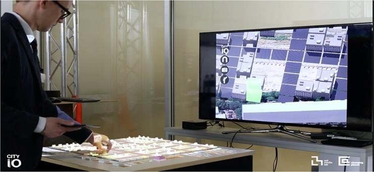
MIT University’s CityScope (Project Overview ‹ cityIO, n.d.) offers a comprehensive platform that supports different stages of urban modelling, simulation, and decision making by leveraging a diverse set of technologies, including VR, AR, AI, and LEGO systems. A comprehensive toolkit that facilitates every stage of insight acquisition, transformation, prediction, and consensus in urban planning and design necessitates the integration of pertinent technologies.
Traffic prediction and analytics
In combination with AI and machine learning, digital twins can help the analysis of different scenarios. For example, it enables traffic managers and urban planners to simulate traffic and congestion conditions and test mitigation strategies. In 2021, Columbia University started a project entitled “Hybrid Twins for Urban Transportation: From Intersections to Citywide Management” to create a digital twin of key intersections and other locations in New York City. The goal of this project is to show how sensing data and machine learning can help to manage and optimize traffic flows [69].
Deep Learning + LEGO: Solving spatial design and urban planning challenges
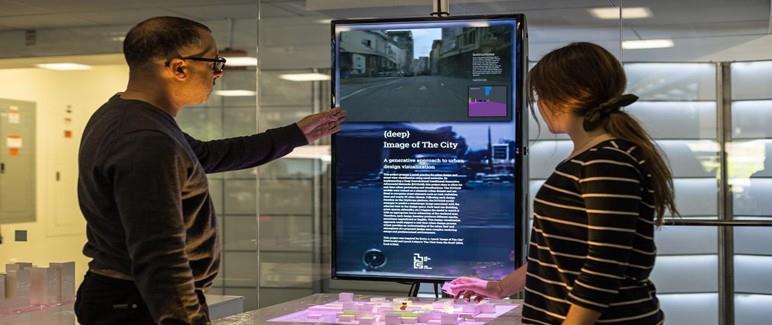
The combination of LEGO and deep learning can offer tangible and digital platforms dedicated to solving spatial design and urban planning challenges. DeepScope is an innovative, real-time urban design visualization platform that requires no setup. It aims to replace traditional urban design methods with a machine-learned, generative visualization technique (A Deep Image of the City | Proceedings of the 11th Annual Symposium on Simulation for Architecture and Urban Design, n.d.).
EASY AND NOVEL WAYS TO ENGAGE COMMUNITIES AROUND ROAD SAFETY La Trobe University, Centre for Technology Infusion 35
Figure 34: SityScope ecosystem for virtual city planning (Project Overview ‹ cityIO, n.d.)
LiDAR+Deep learning: Data collection and processing
LiDAR technology, when combined with deep learning techniques, brings transformative advancements to traffic safety. Deep learning models optimized for edge devices can process LiDAR data in real-time, vital for instant decision-making in dynamic traffic scenarios, and analyse LiDAR scans of roads, bridges, and tunnels to detect wear, structural issues, or potential hazards, facilitating timely maintenance. In (Cycle-Level Traffic Conflict Prediction at Signalized Intersectionswith LiDAR Data and Bayesian Deep Learning by Lai Zheng, Peijie Wu, Wei Wei, Zhenlin Hu, Mohamed Essa :: SSRN, n.d.), a variety of stateof-the-art models are proposed for real-time road safety data collection and prediction. It proposed a method for predicting traffic conflicts at signalized intersections using deep learning and LiDAR data.
EASY AND NOVEL WAYS TO ENGAGE COMMUNITIES AROUND ROAD SAFETY La Trobe University, Centre for Technology Infusion 36
Figure 35: A deep image of the city: generative urban-design visualization (A Deep Image of the City | Proceedings of the 11th Annual Symposium on Simulation for Architecture and Urban Design, n.d.)
Acknowledgement
We extend our sincerest gratitude to the following organizations and companies for their invaluable contributions and insightful participation in the interviews conducted for this project:
• Transport Accident Commission - TAC
• Ignition Immersive
• Canopy Creative
• 7-YM
• 7dx
• OKTAL SYDAC
• The Evolved Group
• Spatial Media
• Road Safety Education Victoria
• Think Digital
• GM LLEN
• Wyndham Tech School
• Elefent
• MIT India
• Phoria
Their expertise, cooperation, and willingness to share their knowledge played a pivotal role in shaping the outcomes of this study. We are deeply appreciative of their time and dedication.
EASY AND NOVEL WAYS TO ENGAGE COMMUNITIES AROUND ROAD SAFETY La Trobe University, Centre for Technology Infusion 37
REFERENCES
A deep image of the city | Proceedings of the 11th Annual Symposium on Simulation for Architecture and Urban Design. (n.d.). Retrieved November 17, 2023, from https://dl.acm.org/doi/ abs/10.5555/3465085.3465108
Amazon Mechanical Turk. (n.d.). Retrieved November 17, 2023, from https://www.mturk.com/
Ameddah, M., Das, B., & Almhana, J. (2018) Cloud-Assisted Real-Time Road Condition Monitoring System for Vehicles. https://doi.org/10.1109/GLOCOM.2018.8647334
ArcGIS StoryMaps. (n.d.) ArcGIS StoryMaps. Retrieved November 17, 2023, from https://storymaps.arcgis.com
Arility Augmented Reality Learning App. (n.d.) Retrieved November 17, 2023, from https://www.arility.com/
CARLA democratizes autonomous vehicle R&D with free open-source simulator. (n.d.). Retrieved November 17, 2023, from https://www.unrealengine.com/en-US/spotlights/carla-democratizes-autonomous-vehicle-r-d-with-free-open-source-simulator
Chen, C., Yao, G., Liu, L., Pei, Q., Song, H., & Dustdar, S. (2023). A Cooperative Vehicle-Infrastructure System for Road Hazards Detection With Edge Intelligence. IEEE Transactions on Intelligent Transportation Systems, 24(5)� https://trid trb.org/view/2173304
Community engagement chatbot. (n.d.). Retrieved November 17, 2023, from https://www.socialcauses.co/chatbot
CreativeTek. (n.d.). Creativitek.Com. Retrieved November 17, 2023, from https://creativitek.com/
C-V2X - BEC Technologies, Inc. (n.d.) Retrieved November 17, 2023, from https://bectechnologies.net/c-v2x/
Cycle-Level Traffic Conflict Prediction at Signalized Intersections with LiDAR Data and Bayesian Deep Learning by Lai Zheng, Peijie Wu, Wei Wei, Zhenlin Hu, Mohamed Essa: SSRN. (n.d.). Retrieved November 17, 2023, from https://papers.ssrn.com/sol3/papers.cfm?abstract_id=4446126
Deepa, D., & Sivasangari, A. (2022). An effective detection and classification of road damages using hybrid deep learning framework. Multimedia Tools and Applications, 82(12), 18151–18184. https://doi.org/10.1007/s11042-022-14001-9
Design & Professional Visusalization Solutions | NVIDIA. (n.d.) NVIDIA. Retrieved November 17, 2023, from https://www.nvidia.com/en-au/design-visualization/technologies/holodeck/
Education. (n.d.) Retrieved November 17, 2023, from https://visionzero.dc.gov/pages/education
Elafent. (n.d.) Retrieved November 17, 2023, from https://elafent.com/
Esri Startups Fuse Communication Media with GIS. (2019, February 1)� Esri� https://www.esri.com/about/
EASY AND NOVEL WAYS TO ENGAGE COMMUNITIES AROUND ROAD SAFETY La Trobe University, Centre for Technology Infusion 38
newsroom/arcnews/esri-startups-fuse-communication-media-with-gis/ Fleet Fuel Card With Rewards | Boost Fleet Driver Performance & Retention Milesmate. (n.d.). Retrieved November 17, 2023, from https://gypsee.ai/
Fujitsu Launches FEELythm, a Wearable Sensor That Promotes Safer Driving Fujitsu Global. (n.d.)� Retrieved November 17, 2023, from https://www.fujitsu.com/global/about/resources/news/ press-releases/2015/0119-02.html
gene@pbwebdev.com.au. (n.d.). Hector VR®: Harnessing co-design principles to build a mixed reality driving simulator for older drivers. Australasian College of Road Safety. Retrieved November 17, 2023, from http://archive.acrs.org.au/article/hector-vr-harnessing-co-design-principles-to-build-amixed-reality-driving-simulator-for-older-drivers/
Generating AI-Based Potential Accident Scenarios for Autonomous Vehicles | NVIDIA Technical Blog. (n.d.)� Retrieved November 17, 2023, from https://developer.nvidia.com/blog/generating-ai-based-accident-scenarios-for-autonomous-vehicles/ Gilson, K., Mallela, J., Goodrum, P. M., WSP, & University of Colorado Boulder. (2020) Leveraging Augmented Reality for Highway Construction (FHWA-HRT-20-037)� https://rosap.ntl.bts.gov/view/dot/51752
GIS-based spatiotemporal analysis for road traffic crashes; in support of sustainable transportation Planning ScienceDirect. (n.d.). Retrieved November 17, 2023, from https://www.sciencedirect.com/ science/article/pii/S2590198223000830
Hamann, C. J., & Peek-Asa, C. (2017). Examination of adult and child bicyclist safety-relevant events using naturalistic bicycling methodology. Accident; Analysis and Prevention, 102, 1–11. https://doi.org/10.1016/j.aap.2017.02.017
Harirforoush, H. (2017) An integrated GIS-based and spatiotemporal analysis of traffic accidents: A case study in Sherbrooke. https://savoirs.usherbrooke.ca/handle/11143/10574
Hasan, M. Z., Chen, J., Wang, J., Rahman, M. S., Joshi, A., Velipasalar, S., Hegde, C., Sharma, A., & Sarkar, S. (2023). Vision-Language Models can Identify Distracted Driver Behavior from Naturalistic Videos (arXiv:2306.10159). arXiv. https://doi.org/10.48550/arXiv.2306.10159
Hespanhol, L., Tomitsch, M., McArthur, I., Fredericks, J., Schroeter, R., & Foth, M. (2015). Vote as you go: Blending interfaces for community engagement into the urban space. Proceedings of the 7th International Conference on Communities and Technologies, 29–37. https://doi.org/10.1145/2768545.2768553
Home. (n.d.) FranklyAI. Retrieved November 17, 2023, from https://frankly.ai/
Imottesjo, H., & Kain, J.-H. (2022). The Urban CoCreation Lab An Integrated Platform for Remote and Simultaneous Collaborative Urban Planning and Design through Web-Based Desktop 3D Modeling, Head-Mounted Virtual Reality and Mobile Augmented Reality: Prototyping a Minimum Viable Product and Developing Specifications for a Minimum Marketable Product. Applied Sciences, 12(2), Article 2. https://doi.org/10.3390/app12020797
EASY AND NOVEL WAYS TO ENGAGE COMMUNITIES AROUND ROAD SAFETY La Trobe University, Centre for Technology Infusion 39
Improving walkability and road safety in South Yarra. (n.d.). Participate Melbourne. Retrieved November 17, 2023, from https://participate.melbourne.vic.gov.au/south-yarra-road-safety
inCitu | Home. (n.d.). Retrieved November 17, 2023, from https://www.incitu.us/ Innovator | 2020 | Jan/Feb. (n.d.). Retrieved November 17, 2023, from https://www.fhwa.dot.gov/innovation/innovator/issue76/page_01.html
Just Digital Signage is a leading provider and innovator of digital signage solutions (2022, October 19)� https://justdigitalsignage.com.au/about-us/
Khan, N., Muhammad, K., Hussain, T., Nasir, M., Munsif, M., Imran, A. S., & Sajjad, M. (2021) An Adaptive Game-Based Learning Strategy for Children Road Safety Education and Practice in Virtual Space. Sensors, 21(11), Article 11. https://doi.org/10.3390/s21113661
Li, Y., & Zhang, W. (2023). Traffic flow digital twin generation for highway scenario based on radar-camera paired fusion. Scientific Reports, 13(1), Article 1. https://doi.org/10.1038/s41598-023-27696-z
Medury, A., Grembek, O., Loukaitou-Sideris, A., & Shafizadeh, K. (2019). Investigating the underreporting of pedestrian and bicycle crashes in and around university campuses a crowdsourcing approach. Accident Analysis & Prevention, 130, 99–107. https://doi.org/10.1016/j.aap.2017.08.014 micdadmin. (2021,December 6) Intelligent Bicycle Path. Do IoT Fieldlab. https://doiotfieldlab.tudelftcampus.nl/intelligent-bicycle-path/
Mixed reality for public participation in urban and public space design Towards a new way of crowdsourcing more inclusive smart cities | UN-Habitat. (n.d.). Retrieved November 17, 2023, from https://unhabitat.org/mixed-reality-for-public-participation-in-urban-and-public-space-design-towards-a-new-way-of
Pereira, M., Silva, J. C., Pinheiro, M., Carvalho, S., & Santos, G. (2024). Points of interest in the city of Barcelos in Portugal through augmented reality. Internet of Things and Cyber-Physical Systems, 4, 40–48. https://doi.org/10.1016/j.iotcps.2023.07.002
Project Overview ‹ cityIO. (n.d.) MIT Media Lab. Retrieved July 12, 2023, from https://www.media.mit.edu/projects/cityio/overview/
Ransbeeck, W. V. (2016,April5) Gamification in Citizen Participation. CitizenLab’s Blog. https://www.citizenlab.co/blog/civic-engagement/gamification-in-citizen-participation/
Remote Control System for Heavy Machine by 3D VR |Virtual Reality Software(VRsoftware), Civil engineering software, BIM, structure design software, analysis software, simulation software|FORUM8. (n.d.) Retrieved July 12, 2023, from https://www.forum8.co.jp/forum8/remote-control-e.htm
RideOn ski goggles | The world’s first smart ski goggles. (n.d.) Retrieved August 3, 2023, from https://rideonvision.eu/
RiskSens: A Multi-view Learning Approach to Identifying Risky Traffic Locations in Intelligent Transportation Systems Using Social and Remote Sensing | IEEE Conference Publication | IEEE Xplore. (n.d.)� Retrieved November 17, 2023, from https://ieeexplore.ieee.org/document/8621996
EASY AND NOVEL WAYS TO ENGAGE COMMUNITIES AROUND ROAD SAFETY La Trobe University, Centre for Technology Infusion 40
Salazar-Carrillo, J., Torres-Ruiz, M., Davis, C. A., Quintero, R., Moreno-Ibarra, M., & Guzmán, G. (2021)� Traffic Congestion Analysis Based on a Web-GIS and Data Mining of Traffic Events from Twitter. Sensors, 21(9), Article 9. https://doi.org/10.3390/s21092964
Schwartz, B. S., & Bell, T. (2023). Assistive mobile application for real-time 3D spatial audio soundscapes toward improving safe and independent navigation. Electronic Imaging.
Skjermo, J., Roche-Cerasi, I., Moe, D., & Opland, R. (2022). Evaluation of Road Safety Education Program with Virtual Reality Eye Tracking. SN Computer Science, 3(2), 149� https://doi.org/10.1007/s42979-022-01036-w
Solar Speed Radar Signs Traffic Equipment Australia. (n.d.). Traffic Equipment Australia. Retrieved November 17, 2023, from https://trafficequipmentaustralia.com.au/
Start Gamifying Your Driver’s Behavior Today! (n.d.) Retrieved November 17, 2023, from https://axxon.co/blog/gamifying-driving-behavior/
Team, C. (n.d.). CARLA. CARLA Simulator. Retrieved November 17, 2023, from http://carla.org//
This Guy Built a Robot to Write New Episodes of Friends. (n.d.). Retrieved November 17, 2023, from https://nymag.com/intelligencer/2016/01/friends-is-even-better-written-by-a-robot.html
Thompson, K. (n.d.). Gather community feedback on a map with ArcGIS Hub. ArcGIS Blog. Retrieved November 17, 2023, from https://www.esri.com/arcgis-blog/products/arcgis-hub/constituent-engagement/gather-community-feedback-on-a-map/
Traffic | MORAI Inc. (n.d.) Retrieved November 17, 2023, from https://www.morai.ai/traffic
Transport for NSW. (n.d.). Cisco. Retrieved November 17, 2023, from https://www.cisco.com/c/en_au/solutions/industries/transportation/new-south-wales.html
Urban CGI – Digital Twin Technology Company. (n.d.). Retrieved November 17, 2023, from https://www.urbancgi.com/
Urban Co-creation Lab | University of Gothenburg. (2022, November 15)� https://www.gu.se/en/research/ urban-co-creation-lab
UrbanCoCreation data lab. (n.d.) Urban Co-Creation Data Lab. Retrieved November 17, 2023, from https://urbandatalab.pt/
US7468661B2 System and method for monitoring and controlling remote devices Google Patents. (n.d.). Retrieved November 17, 2023, from https://patents.google.com/patent/US7468661B2/en
Valcamonico, D., Baraldi, P., Amigoni, F., & Zio, E. (2021). A Natural Language Processing method for the identification of the factors influencing road accident severity. PHM Society European Conference, 6(1), Article 1. https://doi.org/10.36001/phme.2021.v6i1.2899
Vector LiveSafe: Emergency & Safety Communications App. (n.d.). Retrieved November 17, 2023, from https://www.vectorsolutions.com/solutions/vector-livesafe/mobile-app/?utm_source=vector_ blog&utm_medium=optinmonster_aside&utm_campaign=livesafe
EASY AND NOVEL WAYS TO ENGAGE COMMUNITIES AROUND ROAD SAFETY La Trobe University, Centre for Technology Infusion 41
Virtual CRASH for Public Safety. (n.d.). Virtual CRASH. Retrieved November 17, 2023, from https://www.vcrashusa.com/psafety
Virtual Reality in Education ClassVR. (n.d.). Retrieved November 17, 2023, from https://www.classvr. com/virtual-reality-in-education/
Virtual reality with real benefits | Airbus. (2021, October 28)� https://www.airbus.com/en/newsroom/ news/2017-09-virtual-reality-with-real-benefits
Virtual Singapore. (n.d.) Retrieved July 27, 2023, from https://www.sla.gov.sg/geospatial/gw/virtual-singapore
Visualisation and Virtual Reality. (n.d.) Retrieved November 17, 2023, from https://aecom.com/uk/ services/property-solutions/visualisation-and-virtual-reality/ von Sawitzky, T., Grauschopf, T., & Riener, A. (2022). Hazard Notifications for Cyclists: Comparison of Awareness Message Modalities in a Mixed Reality Study. 27th International Conference on Intelligent User Interfaces, 310–322. https://doi.org/10.1145/3490099.3511127
Wang, Z., Zheng, O., Li, L., Abdel-Aty, M., Cruz-Neira, C., & Islam, Z. (2023). Towards Next Generation of Pedestrian and Connected Vehicle In-the-loop Research: A Digital Twin Co-Simulation Framework. IEEE Transactions on Intelligent Vehicles, 8(4), 2674–2683. https://doi.org/10.1109/TIV.2023.3250353
Wellington Digital Twin | Buildmedia. (n.d.). Retrieved November 17, 2023, from https://buildmedia.com/ work/wellington-digital-twin
Where are the best stops and routes for a bookmobile? Analytics | Dokumentation. (n.d.). Retrieved August 3, 2023, from https://desktop.arcgis.com/de/analytics/case-studies/where-are-the-beststops-and-routes-for-a-bookmobile-.htm
EASY AND NOVEL WAYS TO ENGAGE COMMUNITIES AROUND ROAD SAFETY La Trobe University, Centre for Technology Infusion 42


