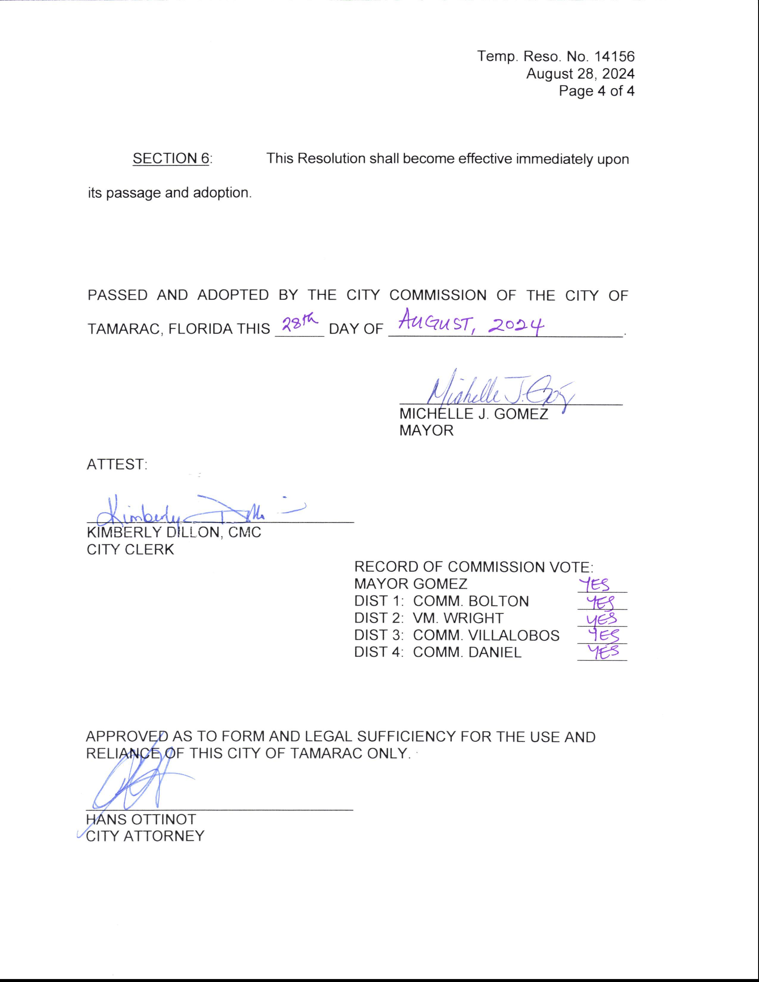
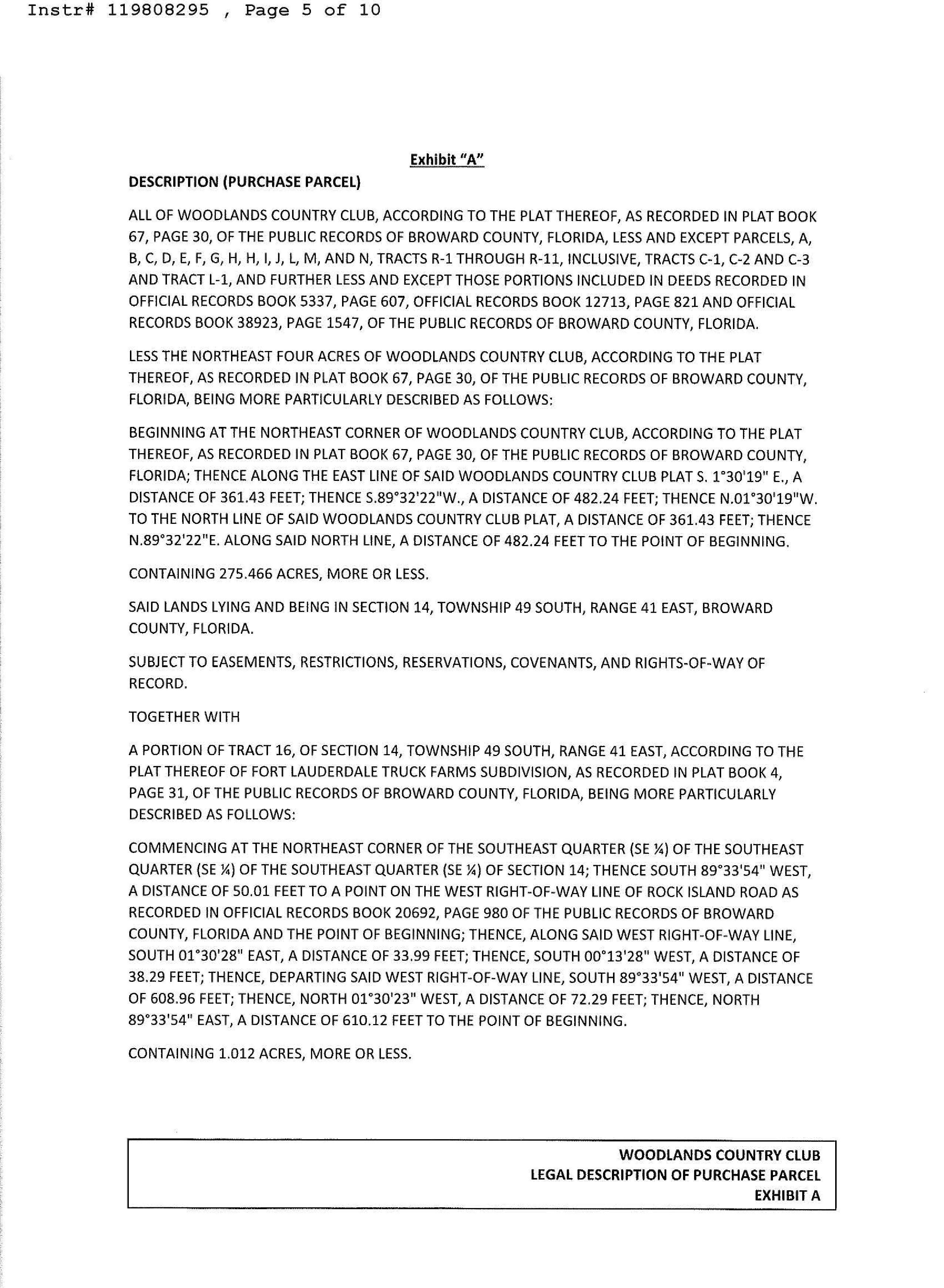
Exhibit A
WOODLANDS - REALLOCATED 7 LOTS
Return to: ( enclose self-addressed stamped envelope)
Name: Scott Backman, Esq.
Address:
Miskel Backman LLP
14 S. E. 4`h Street, Ste. 36 Boca Raton, Florida 33432
This Instrument Prepared by: Scott Backman, Esq. Miskel Backman LLP
14 S. E. 4`' Street, Ste. 36
Boca Raton, Florida 33432
SPACE ABOVE THIS LINE FOR PROCESSING DAT
DEVELOPMENT AGREEMENT
THIS DEVELOPMENT AGREEMENT (" Agreement") is made and entered into this DS day of 20aq, by and between WOODLANDS CLUB HOLDINGS, LLLP, a Delaware limited liability limited partnership with an address of 614 S Federal Highway, Fort Lauderdale, FL 33301, its successors, grantees and assigns (" Developer"), and the CITY OF TAMARAC, a municipal corporation ofthe State of Florida, with an address of 7525 N.W. 88th Avenue, Tamarac, Florida, 33321(" City" and collectively with " Developer" referred to herein as the " Parties").
WITNESSETH:
WHEREAS, Developer is the contract purchaser of approximately two hundred seventy five ( 275) acres of private property formerly utilized as two ( 2) 18- hole golf courses with a clubhouse, parking, recreation, and related facilities legally described on the attached Exhibit " A" Property"), which lies adjacent to the Woodlands residential community comprised of eight (8) individual sections of homes that are generally bounded by Commercial Boulevard on the north, Rock Island Road on the east, NW 441h Street on the south and NW 64th Avenue on the west
Woodlands Community"); and
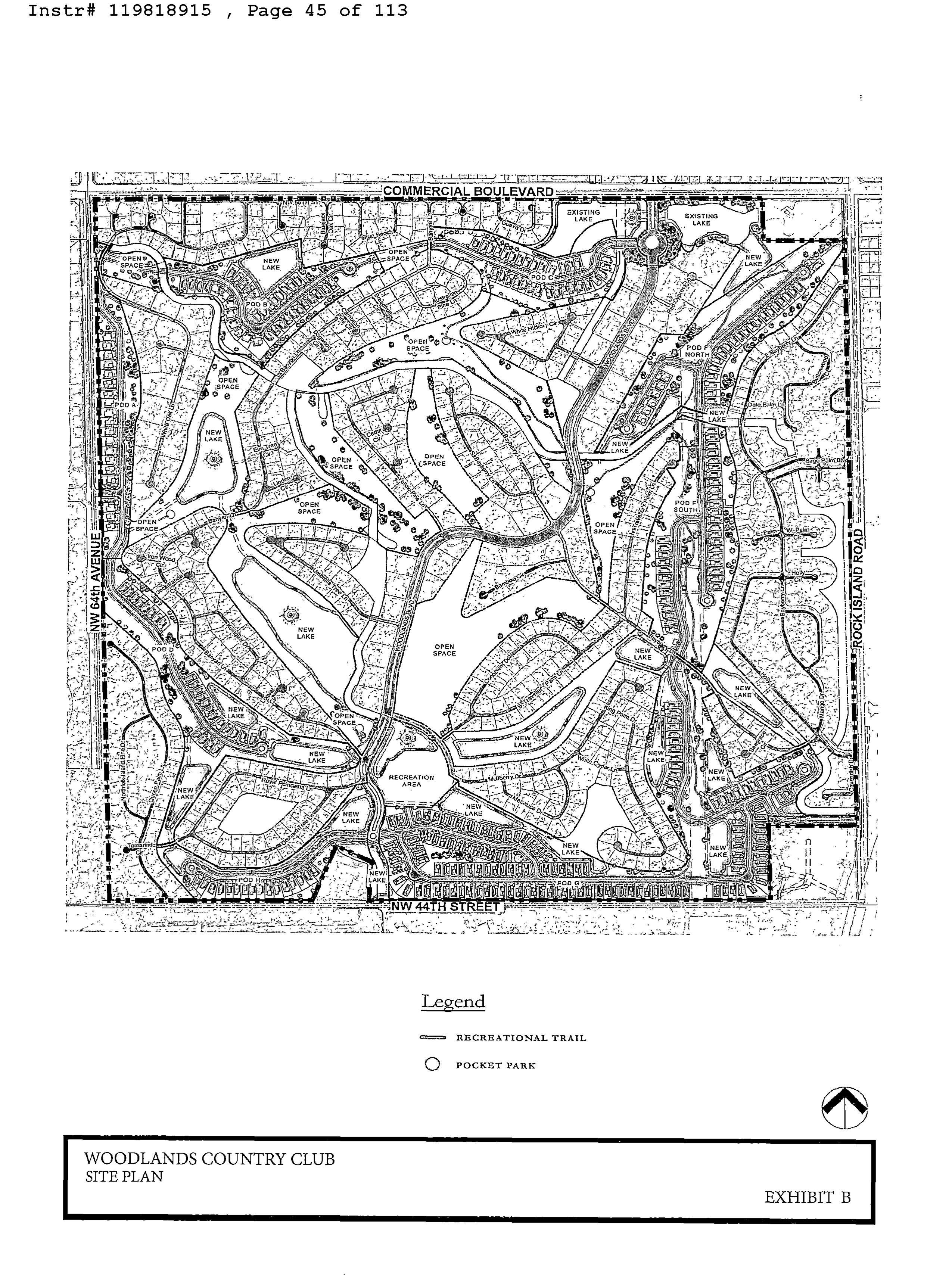
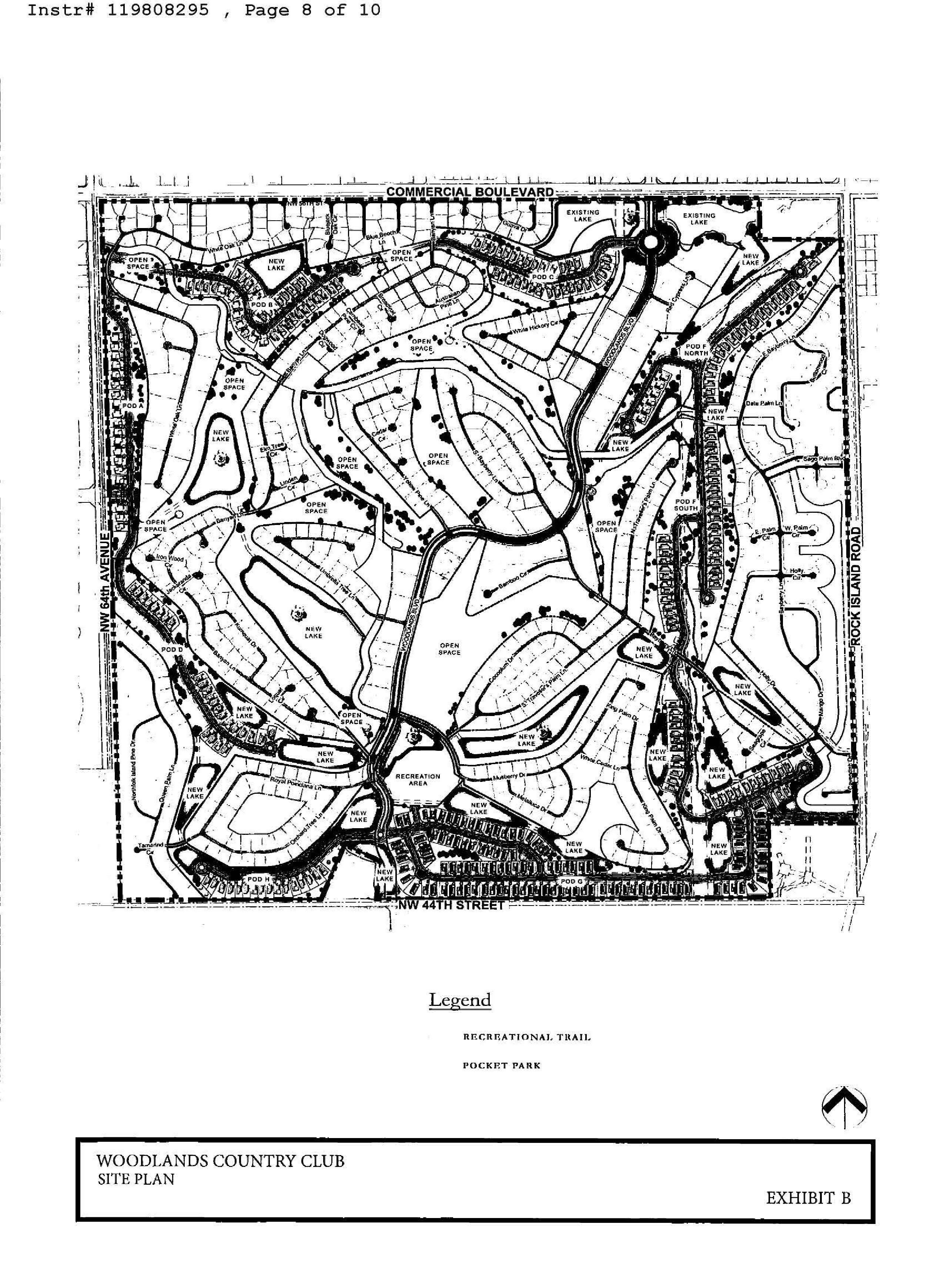
WHEREAS, Developer intends to develop a portion of the Property with no more than three hundred and thirty five (335) single family homes and acceptable accessory uses, including amenities and features, within several pods, Pod A, B, C, D, F, G, and H (collectively referred to herein as the " Residential Pods") and a Recreation Pod (" Recreation Pod" and collectively with the Residential Pods, the " Pods" 1). The proposed locations of the Residential Pods and the Recreation Pod are identified on the site plan (" Site Plan', as may be amended and approved by the City, and attached hereto as Exhibit " B"; and
WHEREAS, the Property is located within the City limits; and
WHEREAS, the Property is governed by the City' s Comprehensive Plan and the City' s Code of Ordinances (" City Code"), including the Land Development Code (" LDC") existing as of the Effective Date of this Agreement; and
WHEREAS, the Parties recognize the benefits of public/ private cooperation and are desirous of entering into this Agreement, which outlines a plan for permitting and development of the Property and related on and off -site improvements; and
WHEREAS, this Agreement is the culmination of negotiations and mutual understandings held by the Parties, and the Parties wish to establish by agreement the terms under which the Property may be developed; and
WHEREAS, the City held two public hearings on March 22, 2023, and November 8, 2023, prior to entering into this Agreement, both of which were properly noticed by publication in a newspaper of general circulation and readership in the County and by mailed notice to the affected property owners in accordance with Section 163. 3225( 2), Florida Statutes.
NOW, THEREFORE, for and in consideration of mutual benefits and the public interest and other good and valuable considerations, the receipt and sufficiency of which are hereby acknowledged, the Parties hereto agree as follows:
1. Recitals. The foregoing recitations are true and correct and are hereby incorporated herein by reference. All exhibits to this Agreement are hereby deemed a part hereof.
2. Purpose. The purpose of this Agreement is to set forth the procedures, rights and obligations of the Parties with regard to the development of the Property consistent with the Comprehensive Plan, City Code, and LDC, and to detail the requirements, commitments and vested rights for developing the Property. All obligations established herein are applicable upon commencing development of the Project.
3. Authorily. This Agreement is entered into under the authority of the Florida Constitution ( including Article VIII, Section 2(b) thereof), the general powers conferred upon municipalities by statute and otherwise ( including Chapter 166, Florida Statutes), the Florida Local Government Development Agreement Act ( the " Act"), Sections 163. 3220 through 163. 3243, Florida Statutes, and the City' s Charter. Pursuant to the Act, the development of the Property shall not be subject to any new LDC regulations or codes, including any and all laws, rules and regulations pertaining to the use and development of land, except under certain conditions set forth in the applicable provisions of the Act. For the purposes of this Agreement, the term City Code means the City Code in effect at the time of approval of this Agreement by the City Commission.
4. Permitted Land Uses. Developer shall develop the Property with the following uses: ( i) a minimum of +/-165 acres and a maximum of three hundred and thirty five ( 335) singlefamily dwelling units located within the Residential Pods, developed at amaximum of2.4 dwelling units per gross acre, and designed in accordance with the design standards established in the LDC
and Paragraph 5 below; ( ii) a new clubhouse and amenity campus located within the Recreation Pod as further described in Paragraph 6 below; ( iii) accessory commercial uses only as follows: sales/ leasing, marketing, construction and administrative offices incidental to the single- family dwelling units, as well as the clubhouse amenity campus located within the Recreation Pod, which may include rooms and facilities which may be rented by residents within the Woodlands Community, and a cafe; ( iv) a minimum of one hundred sixty ( 160) acres of Open Space ( as defined herein), in accordance with the Open Space plan as more fully described in Paragraph 8 below which includes these amenities but are not limited to; a minimum of seven ( 7) pocket parks, which shall include at least one ( 1) shade tree, two ( 2) small trees, shrubs, one ( 1) trash receptacle, one ( 1) dog waste station and one ( 1) bench; ( v) a minimum of four (4) exercise stations; and ( vii) other uses consistent and compatible with the Property' s land use and zoning designations as may be permitted by the City, and to be included in the Site Plan (collectively the "Project"). Developer acknowledges and agrees that the restriction ofthree hundred and thirty five (335) single-family dwelling units is a density limitation on the number of units that may be constructed on the Property that shall be the subject of a Declaration of Restrictive Covenants recorded against the Property, to the benefit of the City, and Sections 1 through 8 of the Woodlands Community, and therefore running with the land, and that Developer, its successors ( whether by merger, consolidation, conveyance, legislative action or otherwise) and assigns, shall not be entitled to increase the number of allowable units in the Project. The Declaration of Restrictive Covenants referenced hereinabove shall be subject to review and approval of the City Attorney prior to recordation, and is attached hereto as Exhibit " G".
5. Residential Pod Development Standards. The three hundred and thirty five ( 335) single- family dwelling units shall be a density restriction for the Project, as identified on the Site
Plan. The seven ( 7) lots not currently reflected on the Site Plan, as a result of the removal of Pod E, as agreed to during the November 8, 2023 City Commission meeting, may be added through a site plan modification processed at a public hearing before the City Commission and in accordance with the City' s LDC. For the avoidance of doubt, Pod E has been removed as a residential pod.
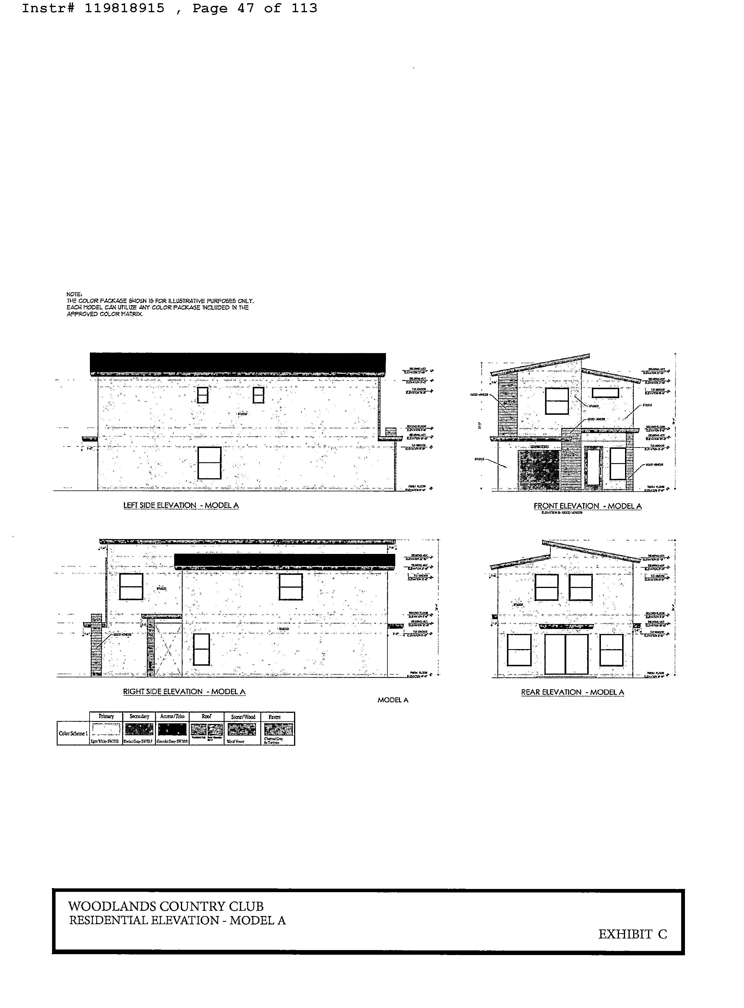
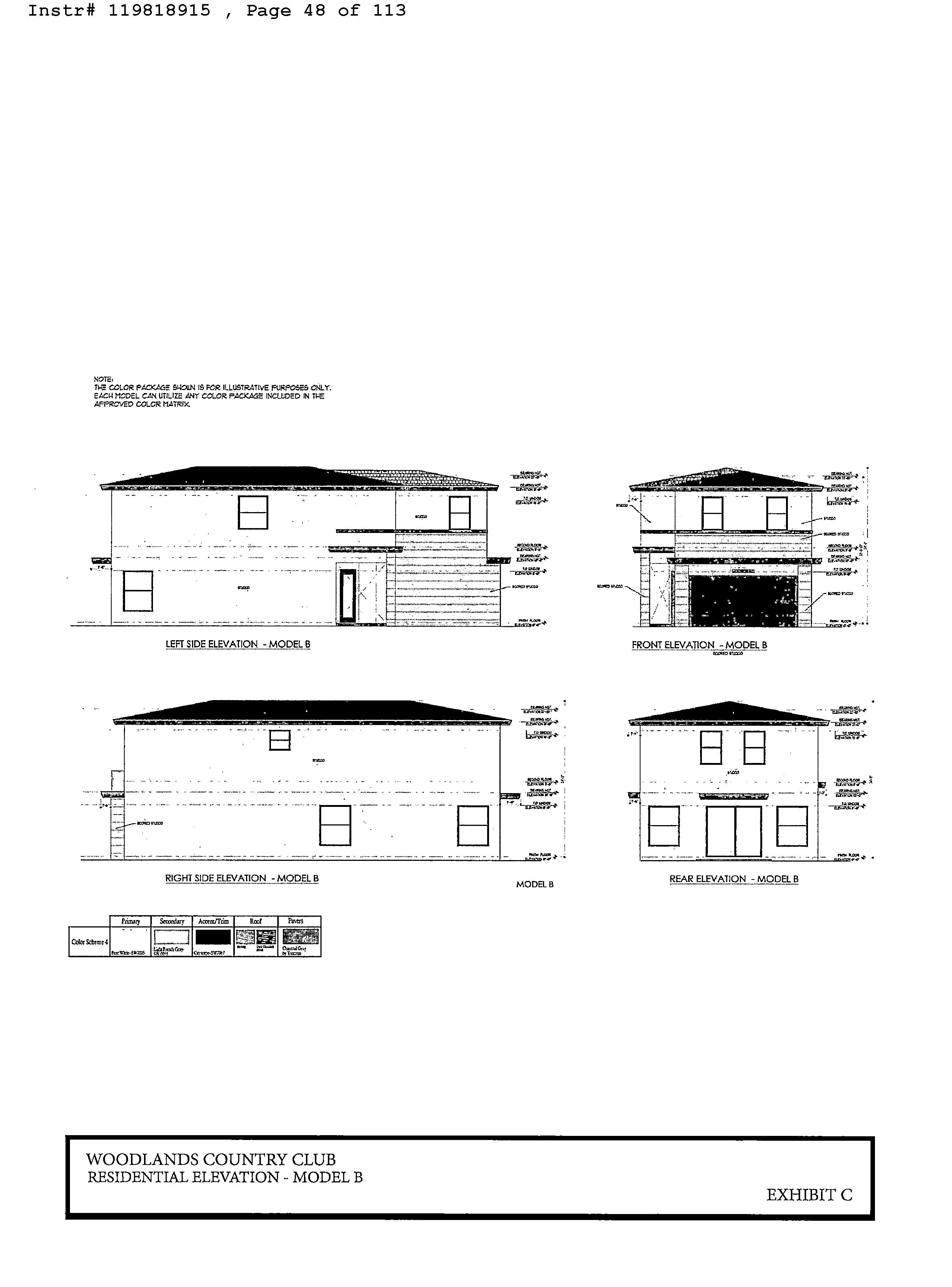
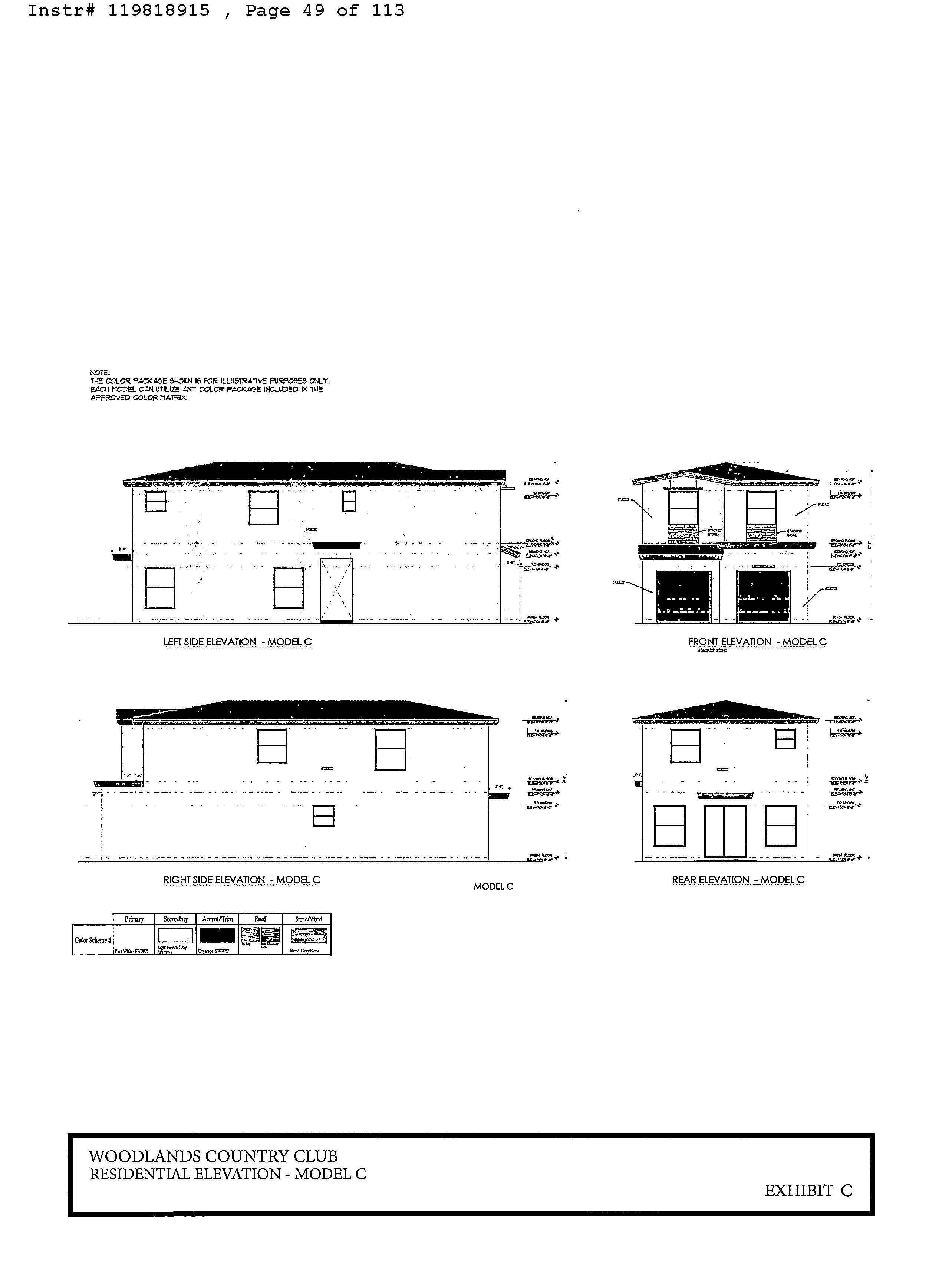
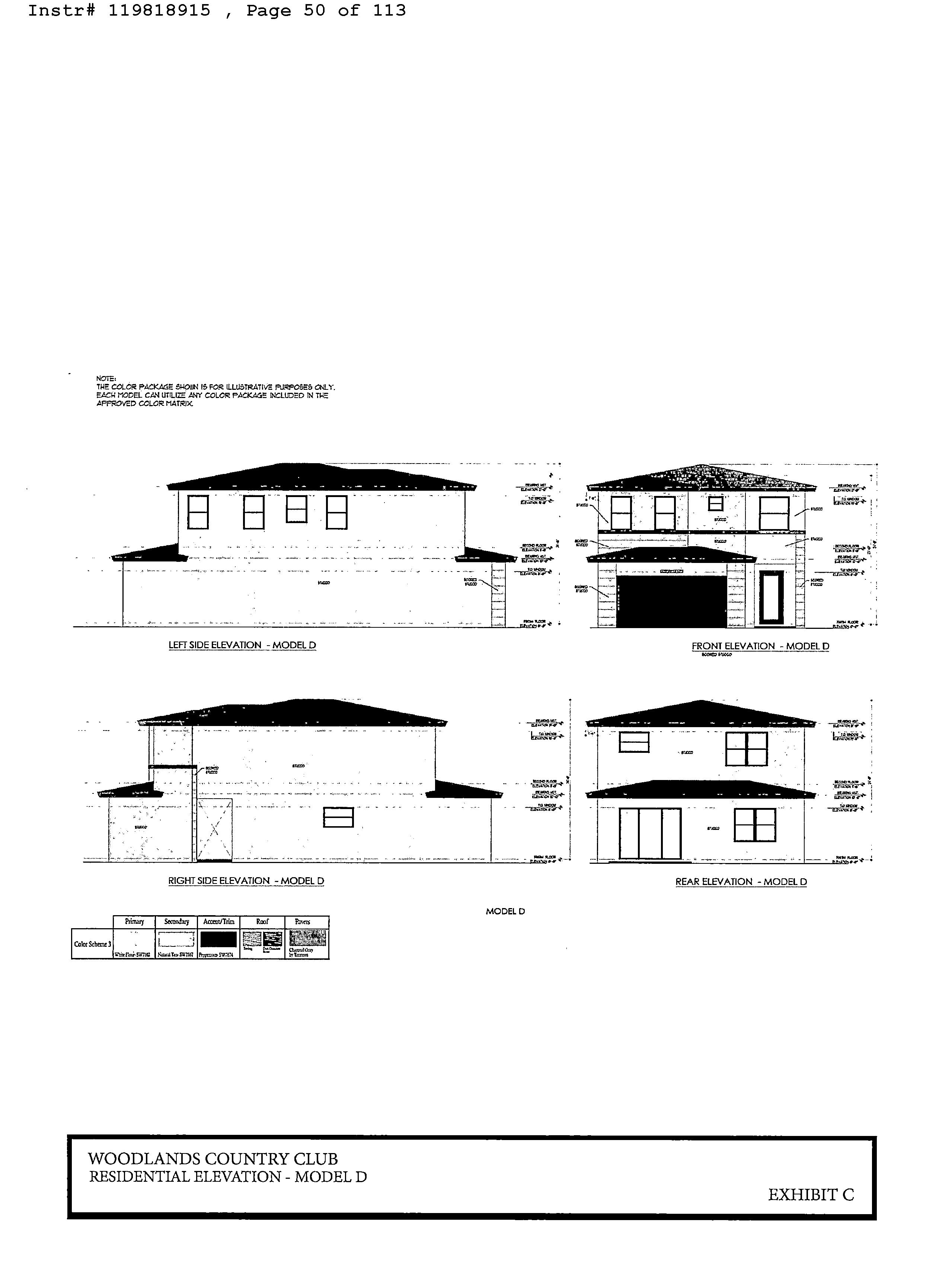
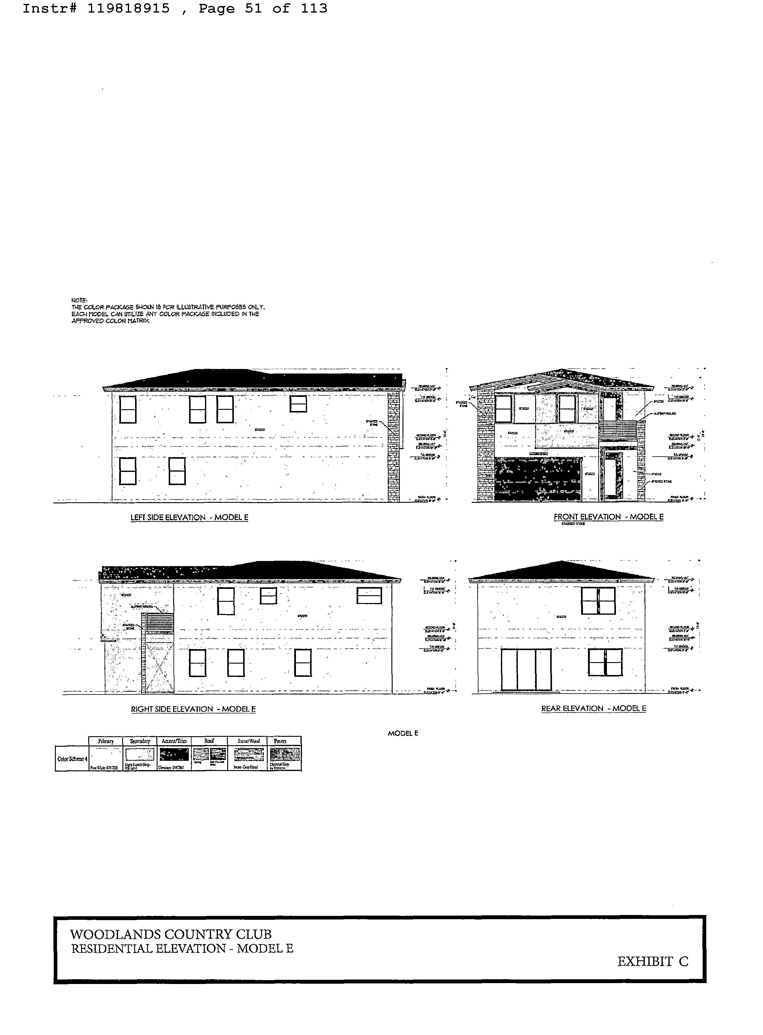
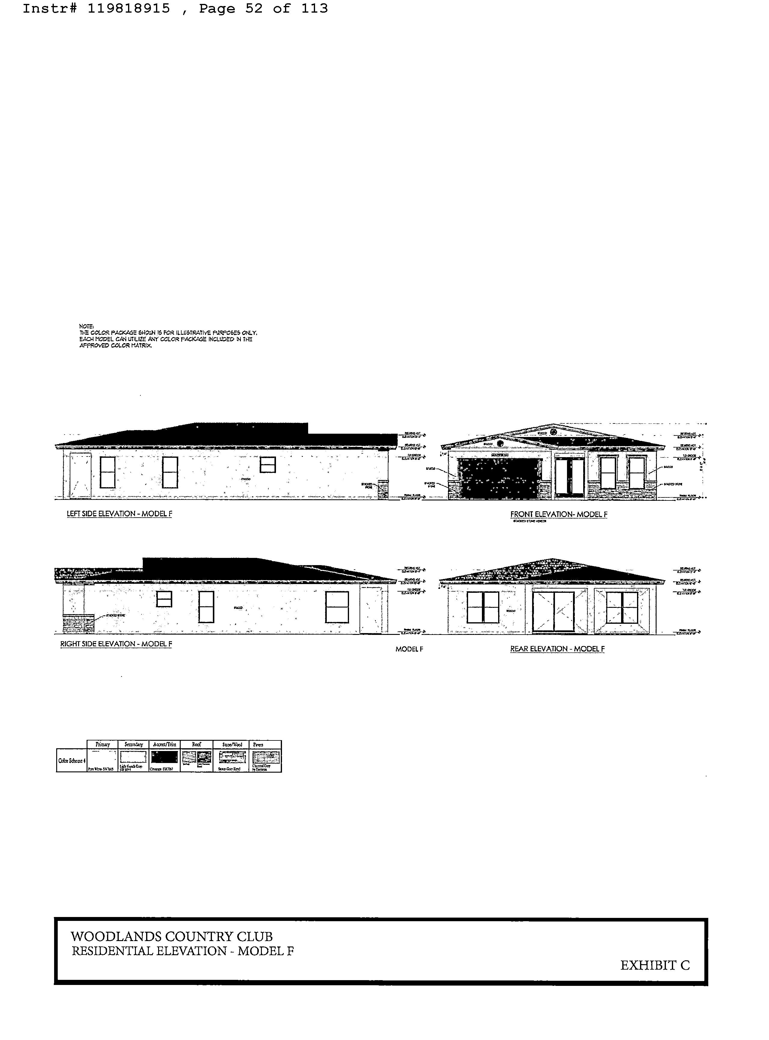
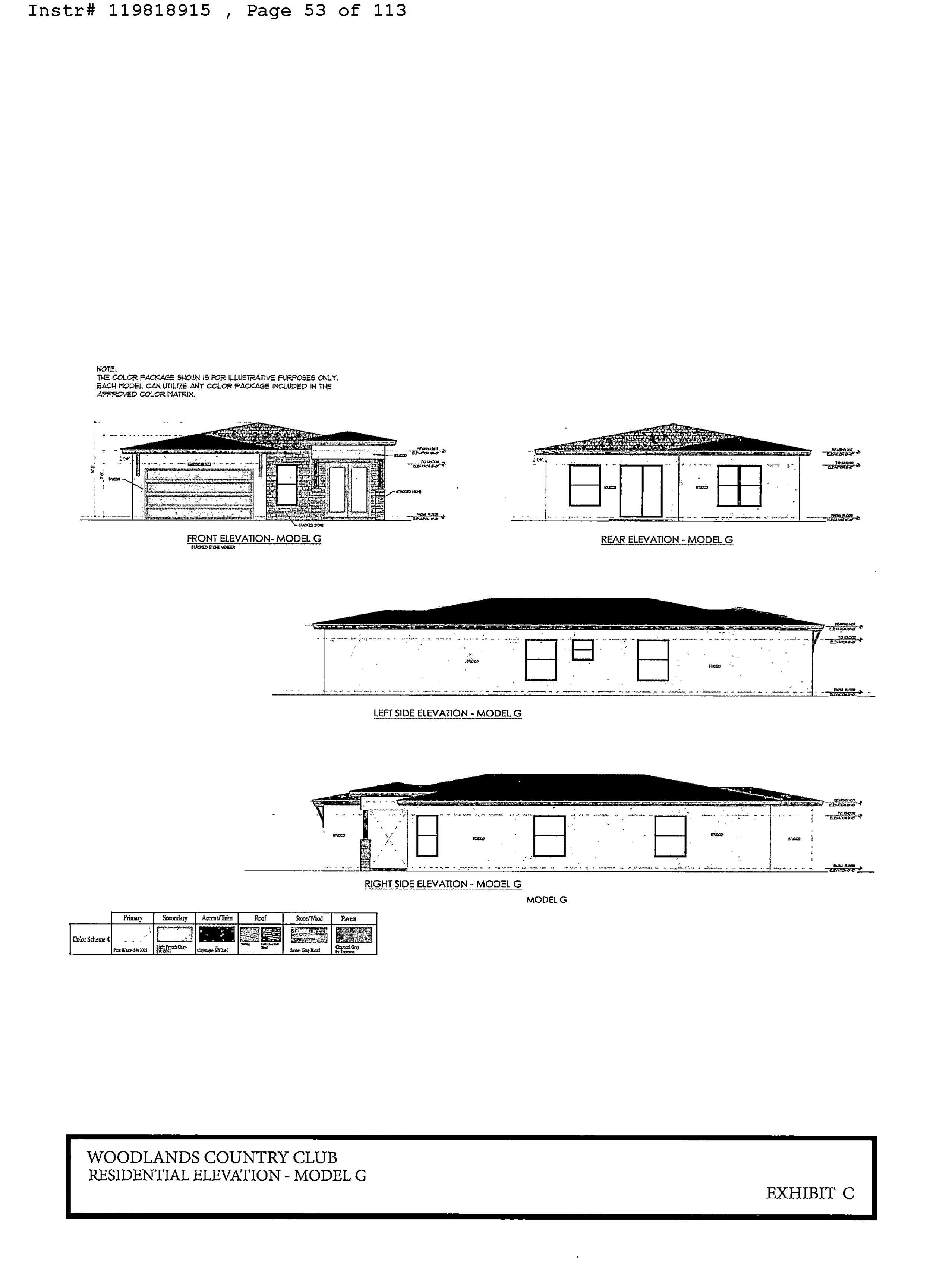
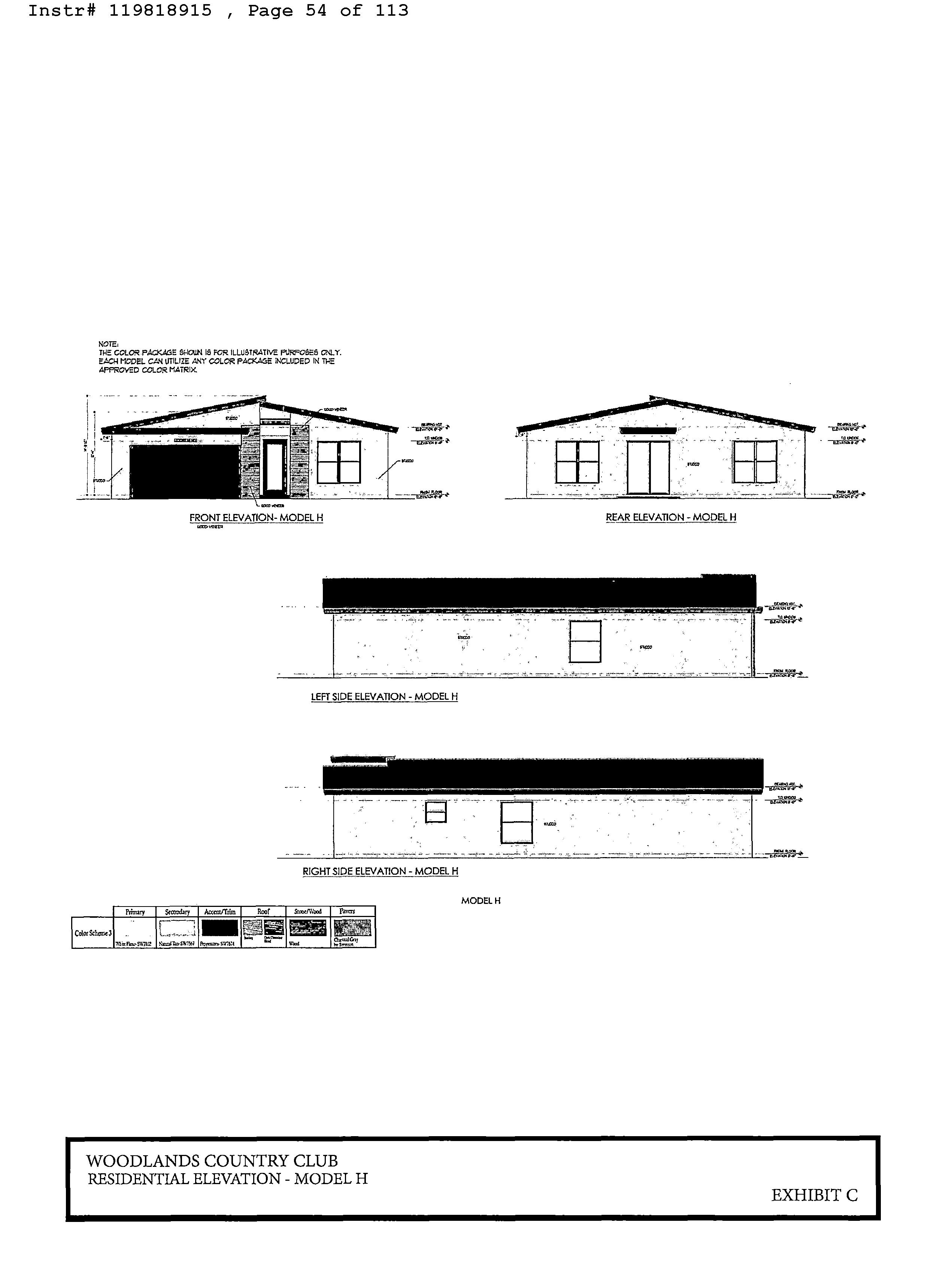
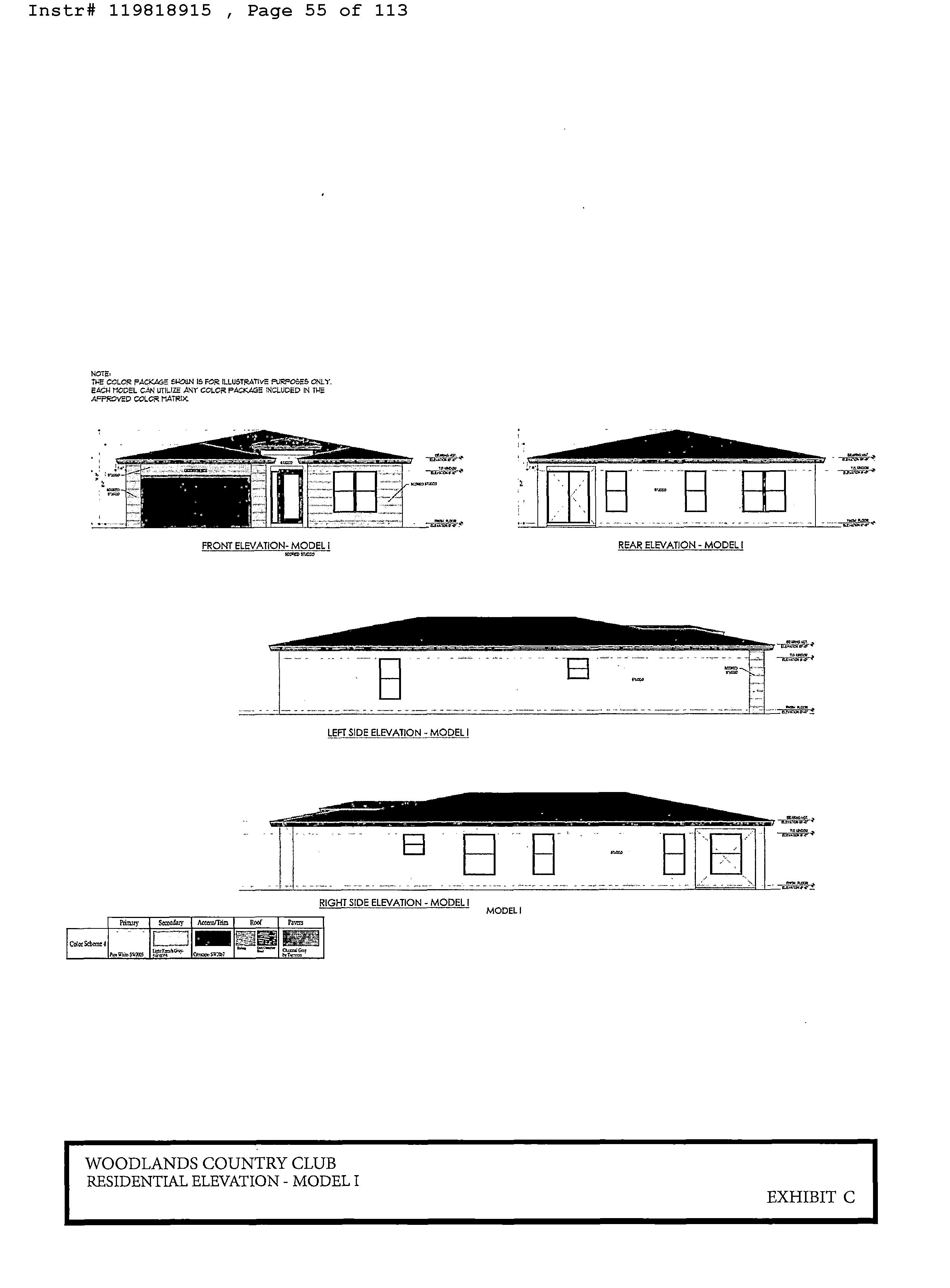
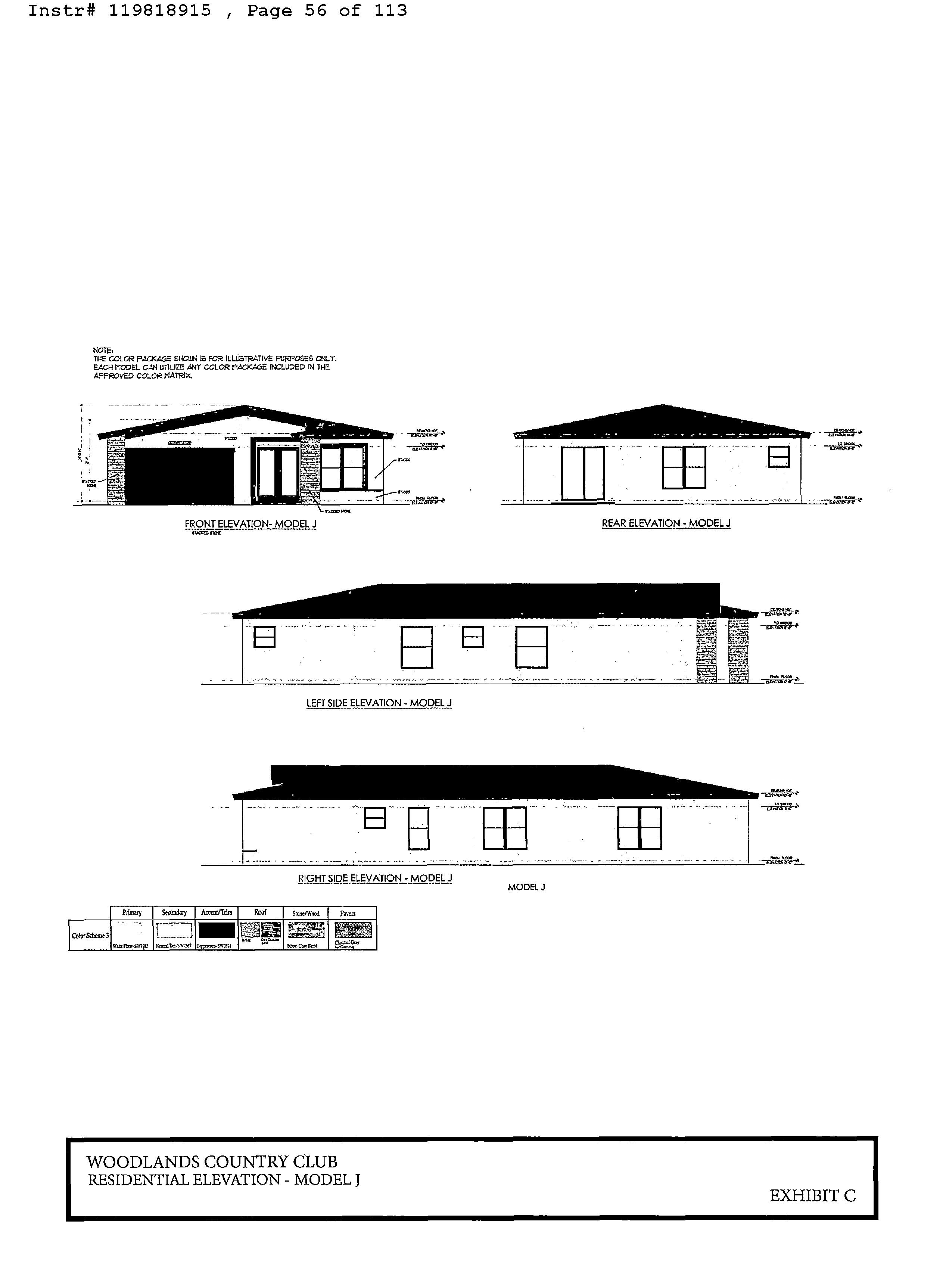
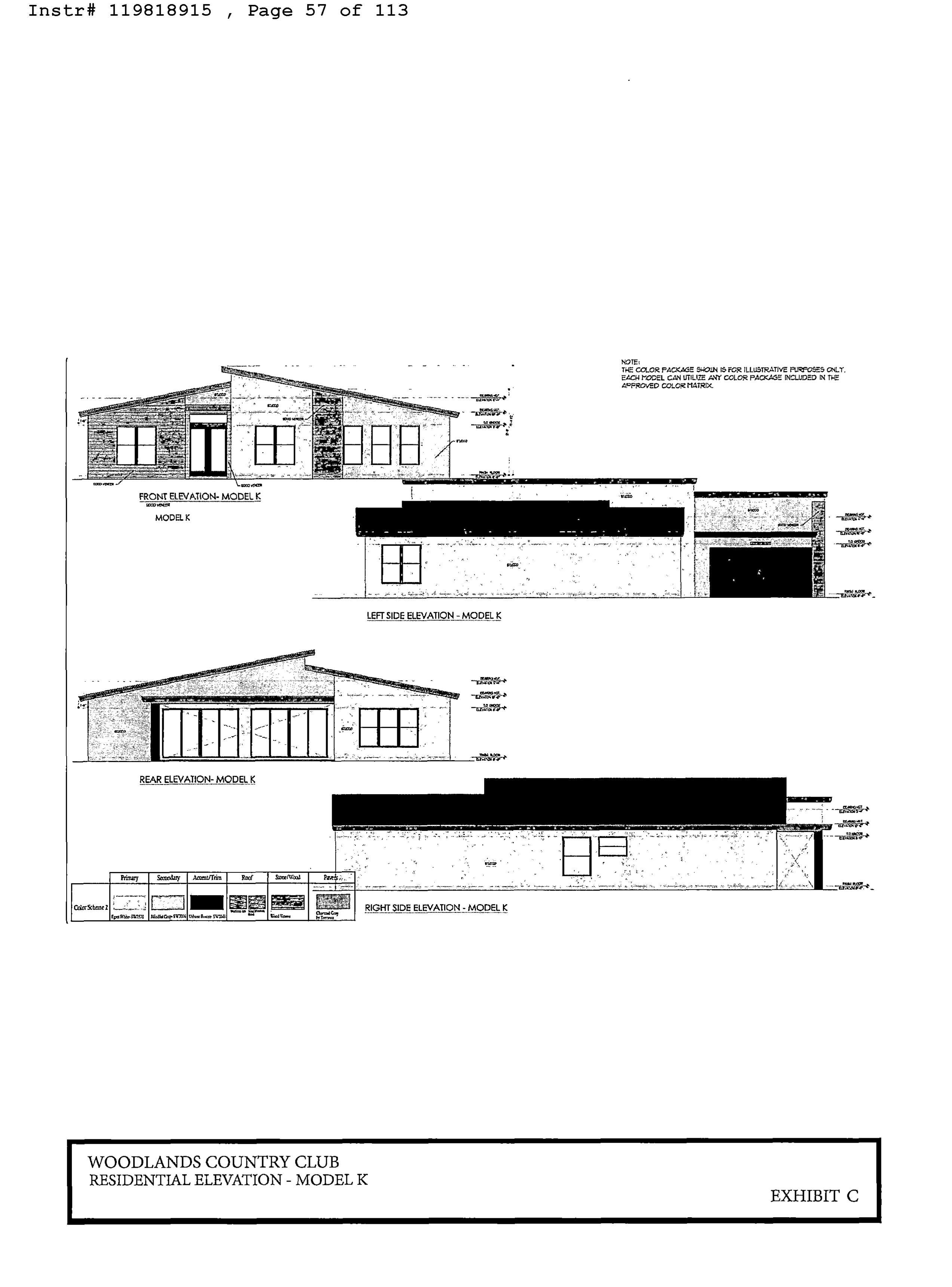
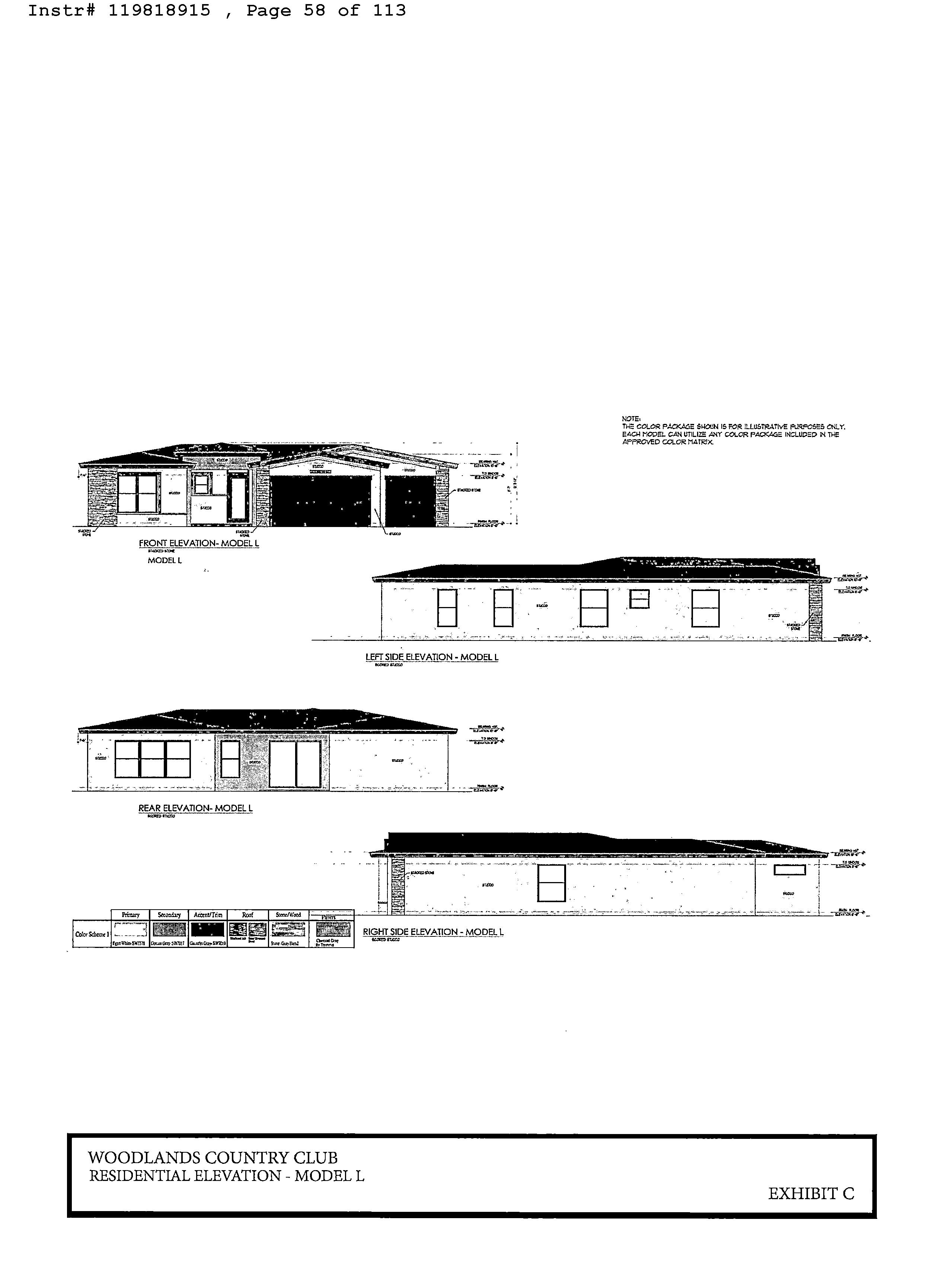
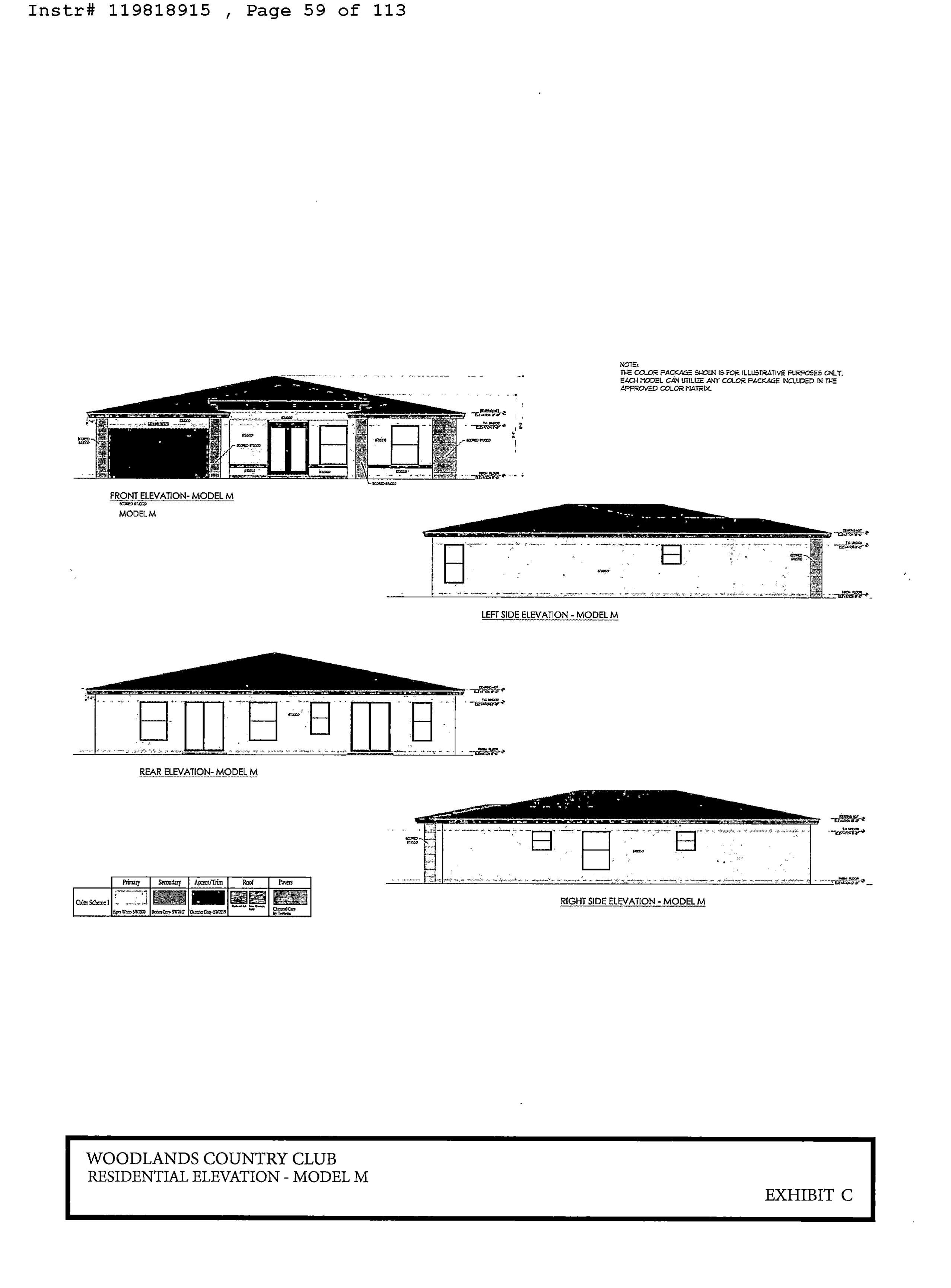
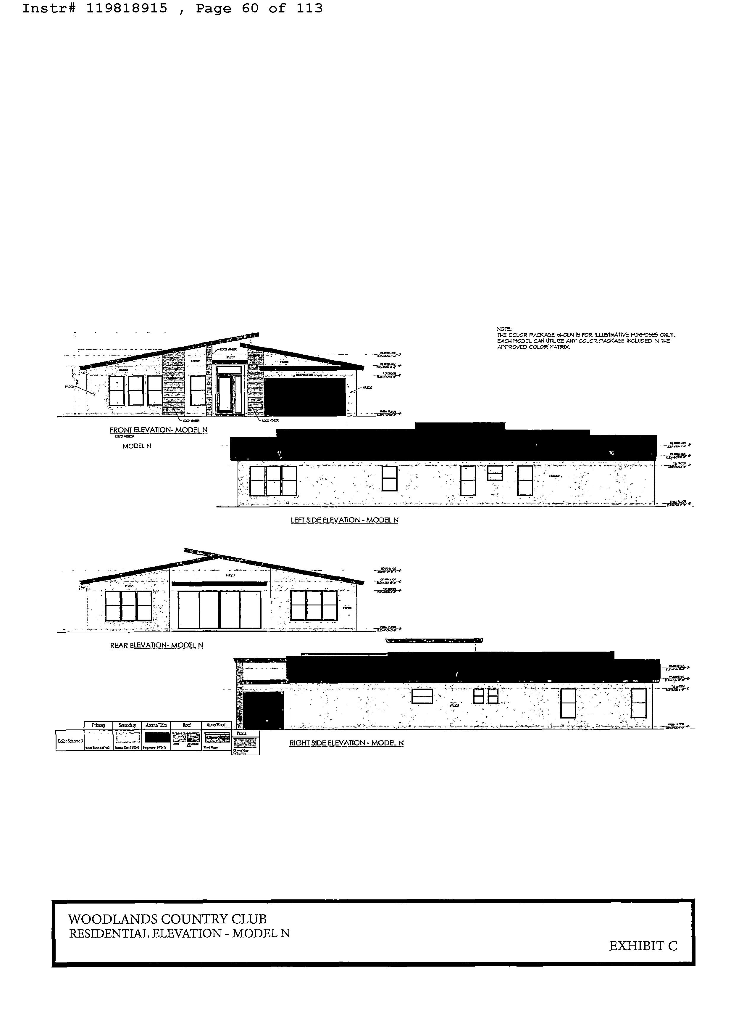
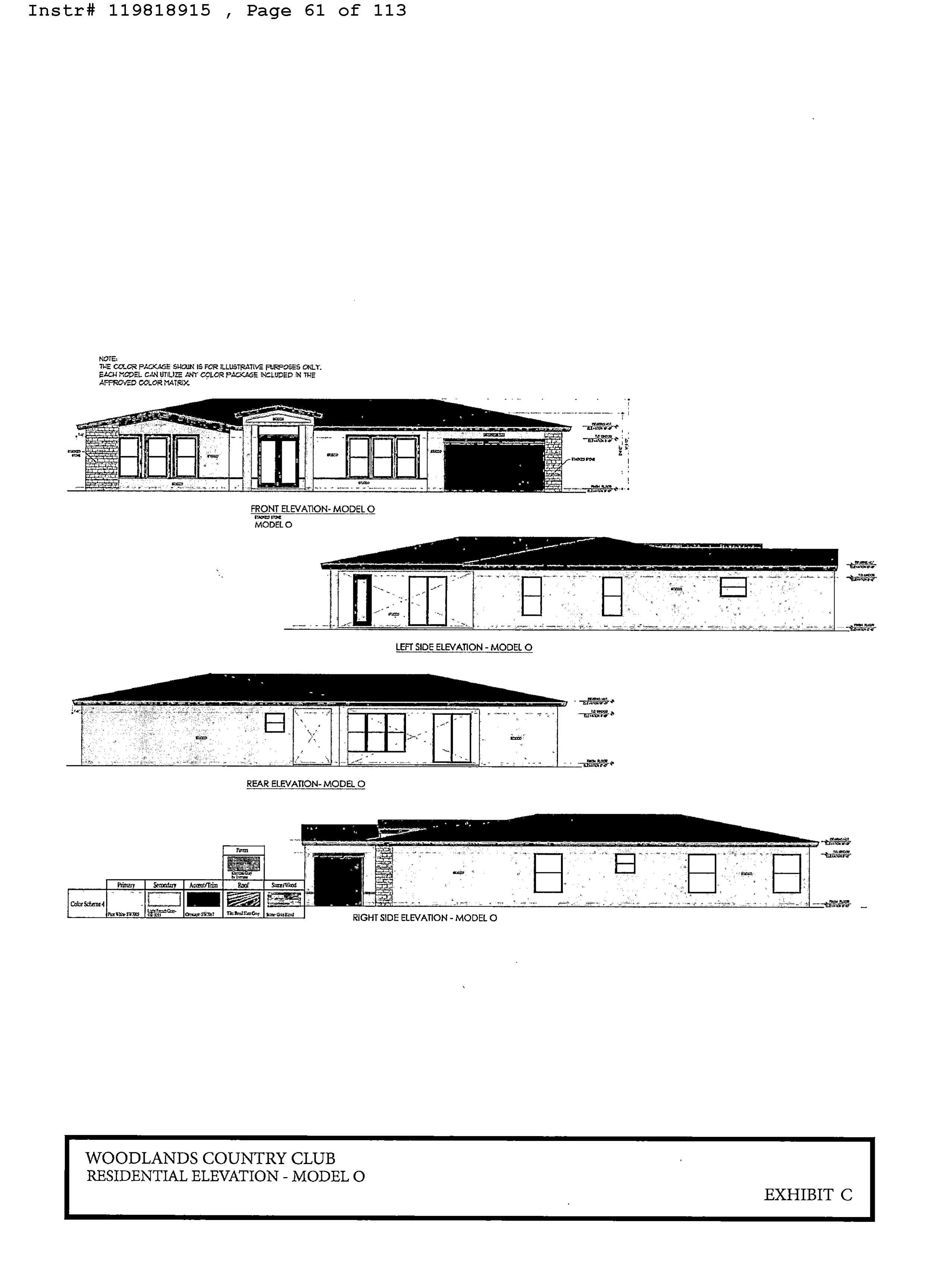
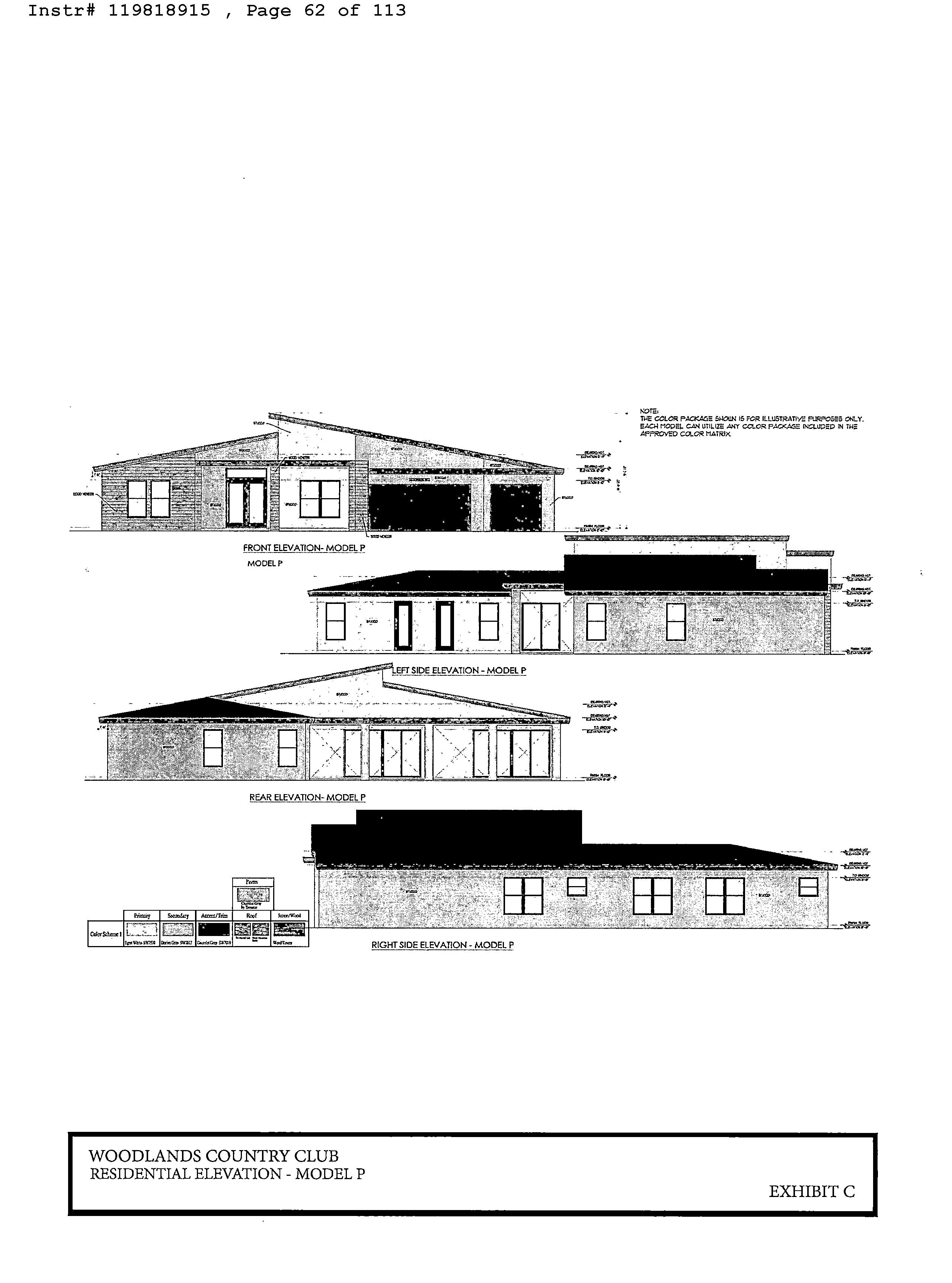
All single-family units constructed within Pods A, B, C, D, F and H shall be restricted to one-story single- family dwelling units, not to exceed thirty ( 30) feet in height. All single- family units constructed within Pod G shall be restricted to one-story and two-story single-family dwelling units, not to exceed thirty ( 30) feet in height. The residential lots shall' be a minimum width of fifty-four feet ( 54% and a minimum lot depth of one hundred feet ( 100'). The single- family dwelling units shall be developed with mid-century modern -like architecture as identified on the conceptual elevations attached hereto as Exhibit " C". Developer agrees that any proposed model homes, which may include sales centers, shall be located within Pod A, Pod C and/ or Pod G.
Developer acknowledges that, unless a homebuyer elects to opt out, all single-family dwelling units within the Project will include fire sprinklers as a standard specification. The City agrees to waive any and all fire sprinkler inspection fees, fire/rescue plan review fees, fire control valve backflow inspection fees, and fire/rescue permit fees in connection to the installation of fire sprinklers within the Project. The City will provide additional relief from applicable fire code requirements ( i.e., hydrant separation, stabilized access, etc...) to the extent permitted by the City Code and the Fire Code in order to encourage new residents to purchase homes with fire sprinklers included. Notwithstanding, the City will conduct all inspections required by the Fire Code.
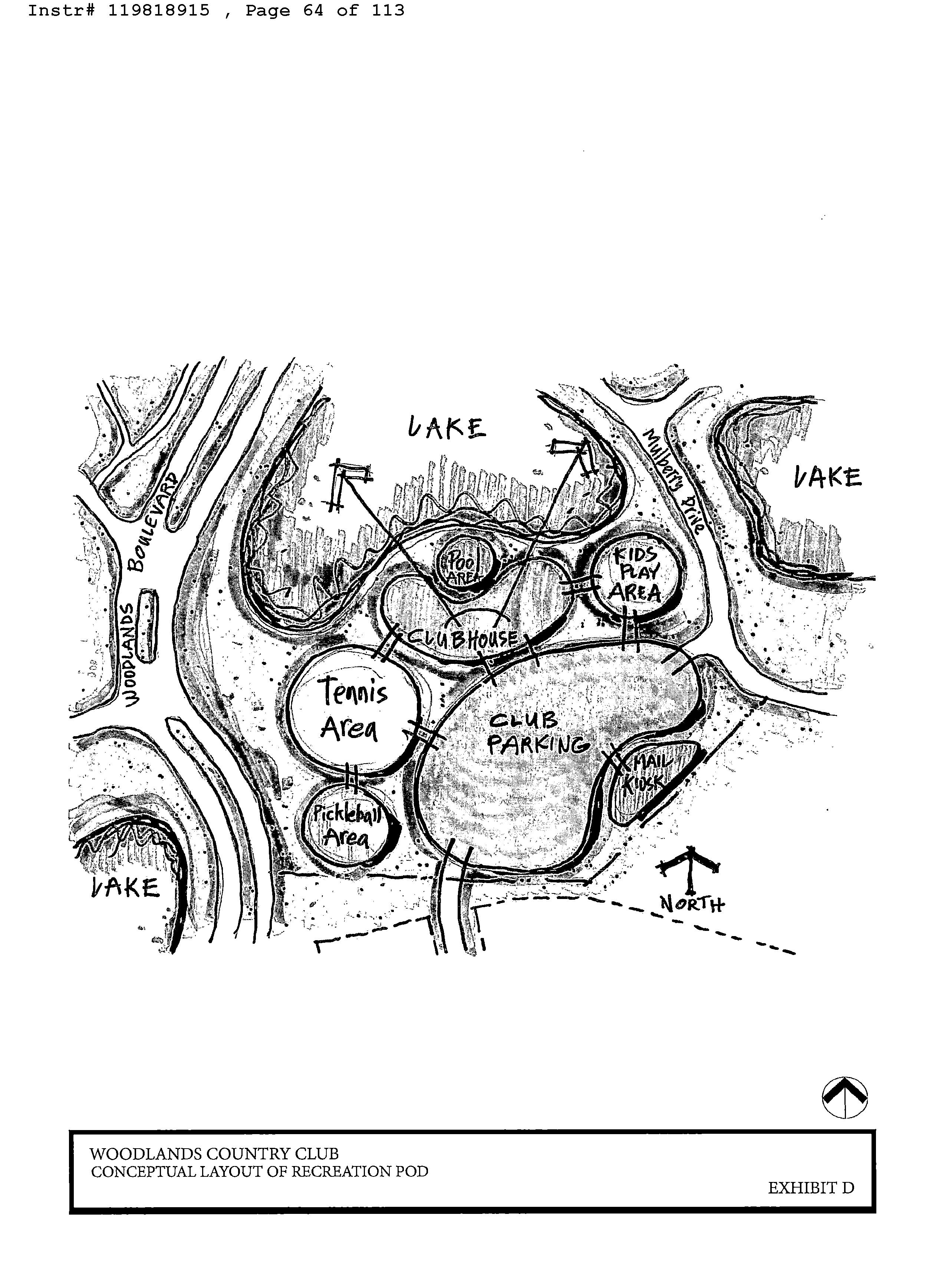
6. Recreation Pod Development Standards. Developer shall construct the following improvements within the Recreation Pod for use by existing and future residents within the Woodlands Community and the Project ( including guests of existing and future residents): ( i)
minimum eight thousand ( 8, 000) gross square foot clubhouse not to exceed sixty ( 60) feet in height; ( ii) two (2) tennis courts; ( iii) two (2) padel ball courts; ( iv) one ( 1) tot lot and/or one ( 1) playground; ( v) one ( 1) fitness center; ( vi) one ( 1) swimming pool; ( vii) one ( 1) hot tub/ spa; ( viii) patio area for seating; ( ix) one ( 1) caf6 with beverage options and a warming kitchen ( with no commercial kitchen); ( x) administrative offices ; ( xi) associated parking for the Amenity Campus and for existing and future residents of the Woodlands Conununity ( including guests); ( xii) mail kiosks; and ( xiii) a concrete pad and conduit for the City' s installation of an electronic interactive information kiosk (collectively referred to herein as the "Amenity Campus"). A conceptual layout of the Recreation Pod, including the clubhouse and Amenity Campus, is attached hereto as Exhibit D". The proposed conceptual layout, plans and uses for the Recreation Pod shall be subject to City review and approval through the formal City site plan approval process prior to issuance of any vertical building permits within the Residential Pods, excluding model homes and any land development permits for any Residential Pod( s) that has received site plan approval. Notwithstanding the above, site plan approval shall be required prior to the issuance of any vertical building permits within the corresponding Residential Pod. In accordance with LDC Section 105. 4( H), any proposed modifications to the site plan for the Recreation Pod that are considered Minor under subsection ( 2)( d) shall be reviewed and approved administratively. Construction of the clubhouse and Amenity Campus must commence prior to the issuance ofthe one hundred and fiftieth (150th) building permit for the vertical construction ofa residential home. The clubhouse and Amenity Campus will be open to existing residents and homeowners, heirs, executors, and assigns of the Woodlands Community for an initial monthly fee not to exceed one hundred dollars 100. 00), subject to increases on an annual basis based on operating costs and expenses to be further defined in the Section 9 governing HOA documents. Notwithstanding anything in this
Agreement otherwise restricting or prohibiting commercial uses, the Recreation Pod may also be used for a clubhouse and Amenity Campus, sales/ leasing, marketing, construction and administrative offices associated with the Project, as well as a possible cafe limited to use by residents and guests of the Project and the Woodlands Community. The administrative offices shall be for the use of Section 9, only. Section 9 ( as defined in Paragraph 9) shall be solely responsible for coordinating and scheduling use of the clubhouse and Amenity Campus for residents and guests of the Woodlands Community. Sales/Leasing, construction and marketing offices shall end upon completion of the Project.
7. Development Applications.
7. 1 Developer initially submitted a land use plan amendment application to the City requesting to change the City' s land use designation from " Commercial Recreation" to "Low (5) Residential", that has been further restricted to a maximum of three ( 3) dwelling units per acre for an approximately +/- 165- acre portion of the Property, as legally described on Exhibit " E" LUPA") 2. A complimentary Land Use Plan Amendment was processed to change the City' s land use designation from " Commercial Recreation" to " Recreation" for approximately 110 acres to satisfy Condition LA in Broward County' s adoption of LUPA PC20- 2 and for the benefit of Woodlands and City residents to ensure an additional protection and to maintain open space.
7.2 Developer concurrently submitted an initial application to the City requesting to rezone an approximately 115-acre portion of the Property from RC, Recreation, to RE, Residential Estate, and to rezone an approximately 50- acre portion of the Property from RC to R-2. This rezoning application has been further revised to rezone the entire +/- 165- acre Property described on Exhibit E" to RE, Residential Estate (" Rezoning").
2
7.
3 On October 29, 2019, Developer submitted an initial site plan application to the City for the development ofthe Residential Pods which Developer amended with a revised site plan application submitted on May 26, 2023, with three hundred and thirty-five ( 335) dwelling units consistent with the Site Plan attached as Exhibit ` B". There shall be no significant modifications made to the Site Plan without fizrther review and approval by the City Commission in accordance with Section 10- 5. 4( H)( 2)( c). Significant changes include any change to a condition of approval for the Applications, as defined herein; any increase in residential density above three hundred and thirty five (335) dwelling units; any decrease in lot size; any decrease in open space; and any change that significantly alters the development' s general function, form, intensity, character, demand on public facilities, impact on adjacent properties, or significantly modify other characteristics from that indicated on the Site Plan. Minor changes to the Site Plan are permitted in order to address technical comments from City staff and to continue to comply with Section 10-5.4(H)(2)( d) ofthe City' s LDC. At the City' s request, a separate site plan application for the clubhouse and Amenity Campus has also been submitted to the City for review and approval by the City Commission.
7.4 In lieu of a plat application, Developer has submitted legal descriptions referencing and describing each Lot and associated Pod by letters and numbers to include meets and bounds descriptions, according to the approved Site Plan to allow for conveyance of each Lot to be consistent with Lot and Pod descriptions typically found on a plat. The City acknowledges that the City Code also allows Developer to plat the Property and that this Section does not waive Developer' s right to pursue platting ofthe Property (or a portion thereof) at a future date.
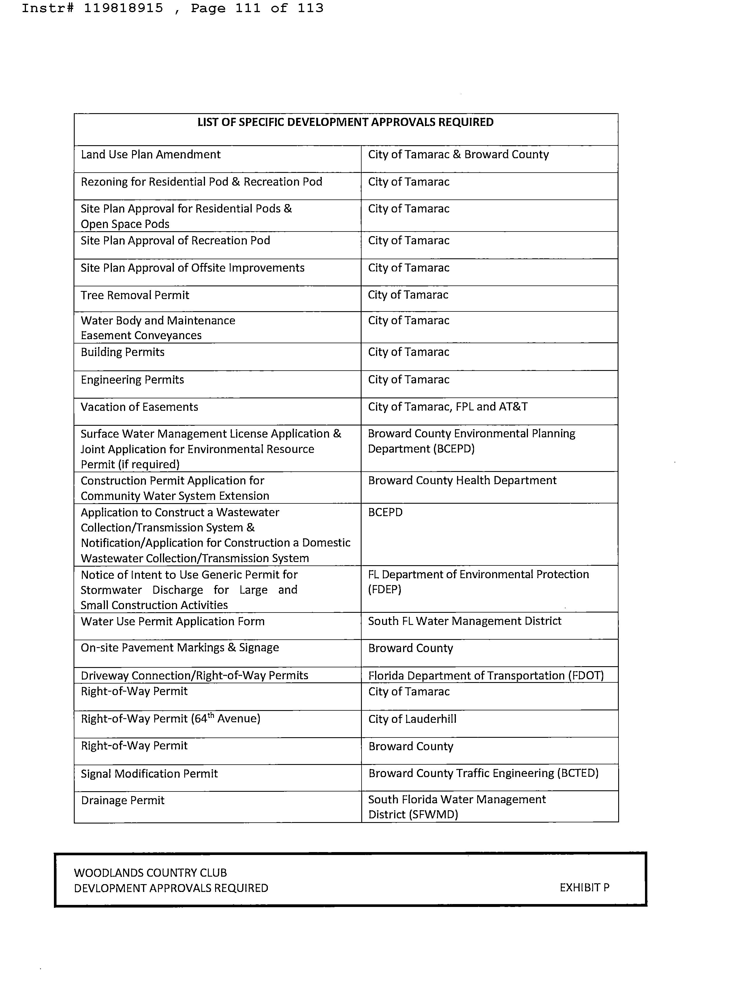
7.5 The LUPA, Rezoning, residential site plan, and clubhouse and Amenity Campus site plan applications are collectively referred to as the " Applications". A list of all required development approvals for the Project is attached hereto as Exhibit " P".
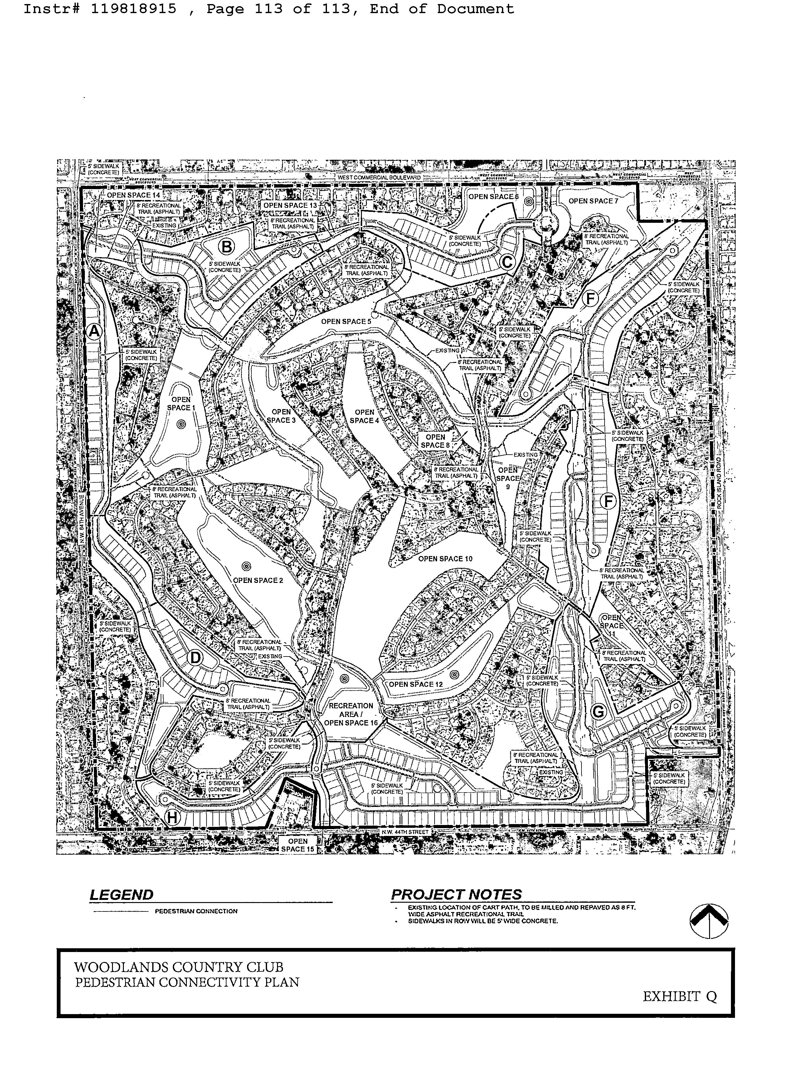
8. Open Space. The Developer shall preserve a minimum of one hundred sixty ( 160) acres within the Property as Open Space, in accordance with the Open Space plan attached hereto as Exhibit " F". For purposes ofthis Agreement, Open Space shall include lakes, buffers, recreation areas, the Recreational Trail as further described in Paragraph 10 herein, other recreational amenities and all common areas within the Project not used for individual residential lot" (" Open Space"). All Open Space within the Project ( except Open Space numbers 2, 6 and 7 shown in Exhibit " F") shall be maintained in perpetuity to the standards required by the City' s Code at the sole cost and expense of Section 9, as further described in Paragraph 9 herein. All Open Space shall be restricted from future residential development through a separate Declaration of Restrictive Covenants in the form attached hereto as Exhibit " G", to be recorded in the Public Records of Broward County, Florida.
9. Section 9. A new Community Development District (" CDD"), master association, and/or other governing association, board, district or other custodial or maintenance entity shall be created in conjunction with the Project pursuant to state and local law (" Section 9"). Section 9 shall be responsible for, at its sole cost and expense, the maintenance of, and required improvements to, all new common areas created as a result of the Project, including the Amenity Campus, Landscape Buffers ( as further defined in Paragraph 16), Recreational Trail ( as further defined in Paragraph 10), perimeter walls and fences ( other than those existing on city property and/orpresently maintained by the City), Open Space and other improvements proposed as part of the Project. Payment by future residents into Section 9 shall be made through an assessment on the tax bill or monthly invoicing through Section 9, as applicable. Notwithstanding the foregoing, Developer has the right to create both a CDD and/ or a master association. Any CDD/ master association created shall only encumber property owned by the Developer and in no way
encumbers ( or will encumber) property owned by any individual Section or any sub -association currently in existence in the Woodlands Community. Developer shall include a statement in the Section 9 Homeowners Association documents restricting rentals to a minimum lease term of no less than twelve ( 12) months.
10. Recreational Trail. Developer shall install a new trail system with seating areas, workout stations, and bollard lighting as may be needed for safety, throughout the Property at its sole cost and expense (" Recreational Tiail"). The cost of improvements toward the Recreational Trail, including seating areas, workout stations and safety lighting, shall be creditable towards the City' s Park and Recreation Impact Fees. The Recreational Trail shall be a pathway intended for outdoor exercise, walking and running through the Woodlands Community as generally shown on the Site Plan. Any existing golf cart paths and cart path bridges utilized for the Recreational Trail must be improved to be consistent with the newly built areas of the Trail, as approved by the City. The Recreational Trail shall include at least four (4) outdoor exercise stations and at least one ( 1) seating area and be accessible to all current and future residents within the Woodlands Community, including future residents and guests ofthe Project. The Recreational Trail and all other pedestrian circulation and connectivity is identified on the Pedestrian Connectivity Plan attached hereto as
Exhibit " Q". The costs of any new sidewalks connecting the Recreation Trail and/or Woodlands Community to the existing sidewalks along Commercial Boulevard, Rock Island Road, NW 641h Avenue orNW 441h Street shall further be creditable towards the City' s Multi -Modal Impact Fees. During installation, the Developer shall also install instruction signs on any exercise equipment and several signs along the Recreational Trail indicating that the Recreational Trail is " private" and for "residents and guests only". Section 9 shall be solely responsible for any and all costs and expenses necessary to ensure perpetual maintenance of the Recreational Trail. Installation of the
Recreational Trail and associated improvements, including bollard lighting, is subject to approval and permitting from all governmental and regulatory agencies, including, without limitation, the City, Broward County (" County"), South Florida Water Management District (" SFWMD") and Florida Power & Light (" FPL").
11. Parking. All parking within the Project shall meet then -current minimum parking requirements as established by the City Code. Each new single family home shall be developed with a minimum of two ( 2) parking spaces within a garage and two ( 2) parking spaces on a driveway within the residential lot. There shall further be a minimum of sixty ( 60) guest parking spaces located throughout Section 9 and the Recreation Pod. Developer shall include a statement in the Section 9 HOA documents substantially similar to the following: " The Developer, Section 9 ( if applicable), any Sub -Association of Section 9 ( if applicable) and all owners of residential dwelling units in the Project, as well as their guests, vendors, couriers, licensees, invitees, contractors, employees, directors, agents, and all other- visitors to the Project, are expressly prohibitedfromparking any vehicles orstaging construction onproperty ownedby the Woodlands Community or any existingprivate residential property within the boundaries ofthe Woodlands Community, except for those areas owned by Developer, Section 9, or any Sub -Association of Section 9 unless express written consent isprovided. Thisprohibition includes, without limitation, construction vehicles or materials during development and construction of the Project".
12. Si 2age. Developer shall be permitted to install temporary signage reasonably satisfactory to the City within the Entrances ( defined in Paragraph 15 below), or other locations approved by the City, for purposes ofmarketing the proposed development and shall be permitted to maintain such signage until all newly constricted residential units have been sold. Developer agrees to submit a Comprehensive Sign Plan (" Sign Plan") at building permit application filing,
establishing a coordinated approach to permanent site signage for the Woodlands Community Entrances and other locations noted for Section 9. The Sign Plan shall provide specifications regarding the signs, such as type, materials, colors, illumination, dimensions and locations. Developer shall install all signs included in the Sign Plan at its sole cost and expense and maintain same including the Woodlands main entrance existing sign, consistent with the City' s Property Maintenance Standards, at its sole cost and expense. The City shall consent to the placement of signage in agreed upon locations within the City' s right-of-way. Developer acknowledges that any signage located within the City' s right-of-way will require all necessary City permits, as well as an access and construction agreement that includes hold harmless and indemnification language in favor of the City.
13. Consistency with the City' s Comprehensive Plan and Land Development Regulations. With the approval of the LUPA and Rezoning applications, the Project is now consistent with the City' s Comprehensive Land Use Plan, City Code and LDCas of the date of approved of this Project.
14. Public Services and Facilities.
14. 1 The City has existing water and wastewater capacity and water and wastewater infrastructure located within the vicinity of the Property; however, this infrastructure must be upgraded, extended and/ or expanded by the Developer to support and provide necessary services to the Project. The City shall provide public services including, but not limited to, drainage excluding private drainage system maintenance), police and fire service, solid waste service, road maintenance, water and sewer, parks and recreation service consistent with land use concurrency, and as otherwise provided in the City' s Charter and City Code (" Public Facilities"). If the City lacks sufficient capacity at the time of LUPA and Rezoning approvals to comply with any
obligations under this section, the Developer shall pay all costs and expenses related to ensure that the Project is able to receive the municipal services. 14.2 Interior Roadways. Developer shall convey all roadways owned by Developer and all roadways constructed for the Project and/or pursuant to this Agreement to the City. The Developer agrees that the City may require roadways to be conveyed as each Pod is completed. A conceptual exhibit depicting the location ofthe proposed newly constructed roadways and existing City -owned public roadways within the Woodlands Community is attached hereto as Exhibit " I" collectively, the " Roadway Improvements"). All roadways constructed pursuant . to this Agreement shall be constructed in accordance with all applicable City standards and provisions of the City Code, as well as all applicable County and State regulations. Developer shall work in good faith with FPL in an effort to allow the City to install no more than three ( 3) electronic banners on street light poles located within City right-of-way within the Woodlands Community and leased from FPL in locations acceptable to FPL and Developer. During the initial construction of the Project, and subject to FPL approval, Developer agrees to install the conduit providing the necessary electricity to the agreed upon and approved light poles for City to install such electronic banners. The City shall be responsible for the operation and maintenance of any such electronic banners. Developer hereby guarantees that those portions of the Roadway Improvements constituting newly constructed roadways installed pursuant to this Agreement shall be free from defects in workmanship and material for a period of one ( 1) year (" Warranty Period") after acceptance by the City and transfer of title to the City by Bill of Sale, if applicable (" Turnover Date"). The acceptance ofthe Roadway Improvements by the City shall be in writing, as evidenced by a Certificate of Completion or other similar document provided by the City in the ordinary course of business. The guarantee for such portion of the Roadway Improvements shall include
Developer repairing and maintaining those covered portions of the Roadway Improvements at no expense to the City during the Warranty Period. In the event ofany claims on this guarantee within the Warranty Period, the Developer shall immediately remedy same and pay all costs, attorney fees, and expenses in relation thereto, and shall in addition, pay the City all reasonable costs and expenses actually incurred by the City in enforcing Developer' s guaranty obligations. Developer shall gate, arm or add a similar feature to the interior roadway system within the Woodlands Community at its sole cost and expense for the Woodlands Community, including the Project, as further described in Paragraph 15 below. Following expiration ofthe Warranty Period ofthe newly constructed interior roadways, the City acknowledges and agrees that it shall be responsible for any and all maintenance costs associated with the existing and new interior roadways within the Woodlands Community. City shall have no maintenance responsibility for any entrance features including the existing fountain and signage), gates, or other access restrictions to the existing and new interior roadways. The interior roadways shall be open and accessible to the public at -large at all times and public access shall not be restricted or limited other than as set forth in Paragraph 15 below. Prior to the issuance of the first building permit for construction of the first residential unit on the Property (excluding model homes), Developer shall work with the City on methodology and pay the full cost for a street improvement study coordinated by the City, including impacts to North Woodlands Boulevard, related to traffic calming after completion of the Project and developer shall pay ONE HUNDRED FIFTY THOUSAND DOLLARS ($ 150,000.00) to the City to be used by the City for any recommended improvements to the interior roadway system of the Woodlands Community on Woodlands Boulevard, Banyan Lane, Bayberry Lane and any other locations identified by the street improvement study, related to the development of new homes within the Woodlands Community. Developer shall contribute an additional ONE HUNDRED
FIFTY THOUSAND DOLLARS ($ 150, 000. 00) to the City to be used by the City for any recommended improvements along North Woodlands Boulevard between Commercial Boulevard and Bailey Road. The $ 150,000.00 payment shall be paid by Developer prior to the issuance of the first building permit for construction of the first residential unit on the Property ( excluding model homes). Any recommended improvements resulting from the street improvement study shall be constructed by City and paid for through use of these funds, which the City can use to offset cost against each set of recommended improvements, if excess funds remain from the implementation of any segment of the street improvement study. Developer' s $ 300, 000. 00 contribution will be considered as a credit and applied against future impact fees imposed, excluding water and sewer capacity fees, and in accordance with City Section 10- 5.7 of the City' s LDC. In addition to other commitments made herein to repair any damage committed by Developer, Developer agrees to, mill and resurface portions of the Woodlands Community street network that are located within one hundred ( 100) feet of the following intersections shared by the Project or as identified on the approved site plan and/ or the approved civil engineering plans for the Project, within one month after the last certificate of occupancy is issued on each
Residential Pod ( subject to review and permitting by the City):
a) Woodlands Boulevard and new Pod C access road;
b) Banyan Lane and new Pod C access road;
c) White Oak Lane and new Pod B access road;
d) White Oak Lane and new Pod A access road;
e) Bayberry Lane and new Pod F access road;
f)Bayberry Lane and new Pod G access road; and
g) Woodlands Boulevard and new Pod G access road.
Developer further agrees there will be no removal of the existing bicycle lanes along Woodlands Boulevard. Developer shall further work with the School Board of Broward County to provide for safe pick-up and drop-off locations for students residing within the Woodlands Community.
Notwithstanding the foregoing, the Interior Roadways shall not be conveyed to the City until the completion of the Project.
14.3
Developer agrees that Developer shall upgrade and expand the Public Facilities in accordance with all applicable governmental statutes, rules, regulations, permits, standards and specifications. Any such improvements to Public Facilities beyond what is required in accordance with City regulations and permit requirements for construction of the Project shall be impact fee creditable. The construction plans for the upgrade and expansion ofPublic Facilities contemplated by this Agreement, including pavement marking and signing plans, shall be submitted to the City Public Services Department prior to commencement of construction. Developer' s construction of the upgraded Public Facilities shall be subject to permitting, inspection and approval by City. Final approval by the City of finished construction shall be consistent with the plans as prepared by the Engineer/Architect of Record and approved by the City.
14. 4
Developer shall pay all costs and expenses associated with the performance ofthis Agreement consistent with Florida Law, specifically the Construction Contract Prompt Payment Law. This includes, but is not limited to, making payment to all contractors and claimants supplying labor, material, supplies, or professional services which are used directly or indirectly in the prosecution of the work, and additionally includes payment of all appropriate cost and expenses, including all fees assessed by the City for approval of design, approval of installation, and permit fees assessed against the work by the City, and all fees charged by the said Developer' s Engineer/ Architect for design and supervision.
14.5 In connection with Developer' s work contemplated in Paragraph 14. 1 and 14. 2 hereof, Developer shall provide to the City ( or cause to be provided) prior to the Turnover Date with adequate insurance, warranties or guaranties, in such forin and amounts as reasonably determined by the City in good faith based on then -prevailing market terms, conditions and forms for comparable developments to the Project in the County (the " Financial Assurances"), covering and/or securing Developer's guaranty obligations hereunder with respect to such work during the Warranty Period. The provisions of §255. 052, Florida Statutes ( 2019), does not apply to this Agreement or to the Financial Assurances therefore. In no event will Developer be required to provide additional Financial Assurances to the City, County, or any other governmental or quasigovernmental authority with respect to Developer' s obligations contained in this Agreement; it being the intention of the Parties that the Financial Assurances represent the sole and exclusive monetary guaranty ofDeveloper' s obligations set forth in this Agreement.
14. 6 Developer acknowledges that its obligations to improve the Public Facilities under this Agreement shall not terminate in the event there are insufficient funds maintained pursuant to such required surety bonds, or any replacement surety bonds, or other financial security to financially assure completion of such obligations ( the " Public Facilities Security"). Specifically, Developer agrees that should it fail or refuse to perform its obligations to install or extend the Public Facilities specified in this Agreement in a timely fashion or fail or refuse to make proper payments therefore to contractors or claimants supplying the Developer with labor, materials, or supplies used, directly or indirectly, by the Developer in the prosecution ofthe work provided for in this Agreement, and such failure continues for more than thirty ( 30) days following written notice from City to Developer, that the City shall have the right (but not the obligation) until the failure is cured, to construct or, pursuant to public advertisement and receipt or bids, cause such
Public Facilities to be extended and installed or cause such appropriate payments to be made, and Developer shall be liable hereunder to pay, reimburse, and indemnify the City for such appropriate payments ( less all sums received from any Public Facilities Security), and upon completion of the said Public Facilities, to pay to, reimburse and indemnify the City for the final total costs thereof less all sums received from such Public Facilities Security), such indemnity including but not limited to, construction, engineering, legal, administrative, and contingent costs together with any damages, direct or consequential, which said City may sustain on account of the failure of Developer to satisfy its obligations with respect to the Public Facilities pursuant to this Agreement; provided, however, the foregoing indemnity will (i) exclude costs and damages arising from the negligence, bad faith or willful misconduct of City, its officers, agents, or employees, and ( ii) automatically terminate following the date Developer completes construction of the Public Facilities pursuant to this Agreement.
14. 7 The Developer shall indemnify and hold harmless the City, its officers, agents, and employees, from and against any and all claims, costs, losses, and damages ( including but not limited to all fees and charges of attorneys and other professionals, and all Court or other dispute resolution costs), liabilities, expenditures, or causes of action of any kind to the extent caused by negligent, reckless, or willful or intentional acts or omissions ofthe Developer and any person or organization directly employed by the Developer to perform or furnish any work pursuant to this Agreement, arising from, relative to, or caused by the Developer' s construction of the Public Facilities. Such indemnification shall specifically include but not be limited to claims, damages, losses, liabilities and expenses arising out of or from: ( a) any act, omission or default of the Developer or its employees or agents, ( including negligent, reckless, willful or intentional acts or omissions); ( b) any and all bodily injuries, sickness, disease or death; ( c) injury to or destruction
of tangible property, including the loss of use resulting therefrom; ( d) other such damages, liabilities, or losses received or sustained by any person or persons during or on account of any construction operations connected with the Public Facilities; ( e) and the violation of any federal, state, county or city laws, by- laws, ordinances or regulations by the Developer or employees in improving the Public Facilities. In the event of any such claim, suit or action for damages, the City shall supply written notice to Developer of such claim. In the event the Developer chooses not to pay the claim and the claim is adjudged as falling within the scope of this indemnity, then the Developer shall promptly reimburse the City for same. Developer agrees, at Developer' s expense after receipt ofwritten notice from the City, to defend any action against the City that falls within the scope of this indemnity, or the City, at the City' s option, may elect to secure its own attorney to defend any such action and the reasonable cost and expenses of such attorney incurred in defending such action shall be payable by Developer, provided however, that the Developer or its insurance carrier, whichever is applicable, shall have the right to approve the City' s selection of legal counsel, which approval shall not be unreasonably withheld or delayed. If the Developer does not raise any objection to an attorney hired by the City within five (5) days of notice, the Developer has waived the right to approve the attorney hired by the City. Additionally, if Developer, after receipt of written notice from the City, fails to make any payment due hereunder to the City, Developer shall pay any reasonable attorney' s fees or costs actually incurred by the City in securing any such payment from the Developer. Nothing contained herein is intended nor shall it be construed to waive the City' s rights and immunities under the common law or Florida Statute § 768.28 as amended from time to time. This obligation shall not be construed to negate, abridge, or otherwise reduce any other right or obligation of indemnity which would otherwise exist in the City' s favor. Notwithstanding anything in this Agreement to the contrary, the
foregoing indemnity will (i) exclude claims, costs, losses, damages, liabilities, expenditures, and causes of action arising from the negligence, bad faith or willful misconduct of City, its officers, agents, or employees, and ( ii) automatically terminate following the date that last Warranty expires or the last Financial Assurance has been released or claims against same have been resolved pursuant to this Agreement.
14. 8 Developer agrees that the construction contract for the Public Facilities shall be with an appropriately licensed contractor that shall: ( a) Indemnify and hold harmless the City of Tamarac, its officers, agents, and employees, from and against any and all claims, costs, losses, and damages ( including but not limited to all fees and charges ofattorneys, and other professionals, and all Court or other dispute resolution costs), liabilities, expenditures, or causes of action ofany kind ( including negligent, reckless, or willful or intentional acts or omissions of the Contractor and any person or organization directly or indirectly employed by the Contractor to perform or furnish any work or anyone for whose acts any ofthem may be liable), arising from, relative to, or caused by the performance of the Public Facilities. Such indemnification shall specifically include the required insurance coverage written in accordance with the hazards and magnitude of this Project, but in no circumstance a lesser coverage amount nor more restrictive than the limits of liability and schedule of coverage' s described in Exhibit " J". The City shall have third party right to enforce the indemnification provisions of any construction contract for Public Facilities as required by this paragraph 14.8.
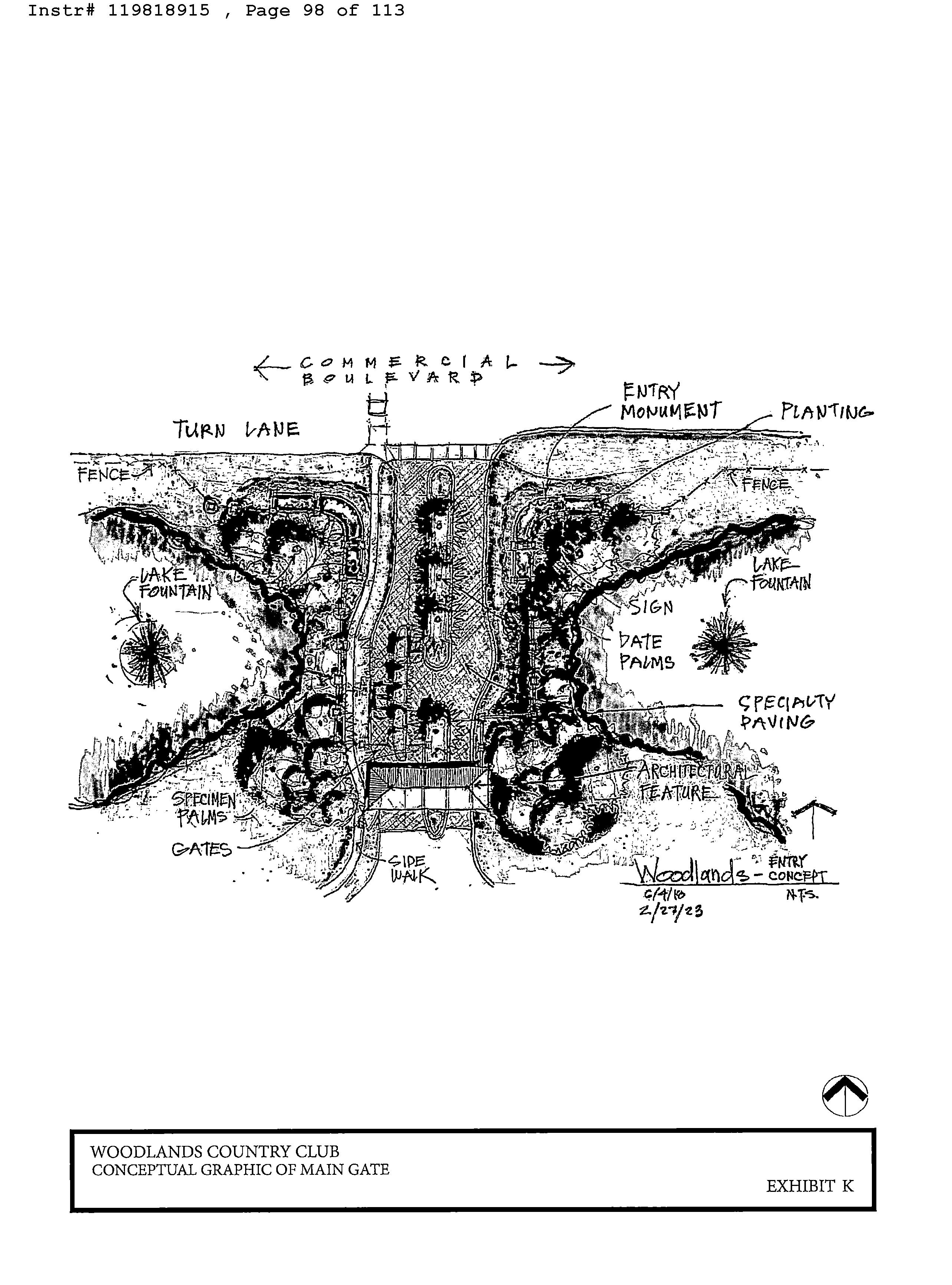
15. Entrance Renovations. One or more access points to or within the Woodlands Community may include gated entry features. Once conveyed, all roadways within the boundaries of the Woodlands Community shall be public roadways owned and controlled by the City. Developer shall commence construction of the improvements and upgrades to the main entrance
of the Woodlands Community, located at the intersection of Woodlands Boulevard and Commercial Boulevard (" Main Gate"), prior to, or concurrent with, the issuance of the first vertical building permit for the construction of a new single-family home, excluding the model units. The location of the Main Gate is more specifically described on Exhibit " I". A conceptual plan identifying the proposed improvements and upgrades to the Main Gate, are more specifically described on Exhibit " K", and generally include vehicular gates or a feature that serves a similar function, upgraded landscaping and monument signage. The Main Gate shall consist of a minimum of one resident lane and one guest lane for access to the Woodlands Community. All vendors, guests, and prospective buyers for the Woodlands Community and the Project will be prohibited from using any entrance to the Woodlands Community other than the Main Gate. Developer further agrees that the Main Gate will be sensor activated, include license plate readers for safety and security, and will not prohibit access to the public roadways of the Woodlands Community and the Project, generally. Developer may elect to further enhance the Main Gate, including any signage, lake, fountain, entrance features and related improvements, with an art component, which may be used to fulfill the Public Art Program requirements under Chapter 5, Article XI, Section 5- 302 of the City' s Code. All gated ingress and egress points, located in the areas identified on Exhibit "I" and Exhibit " K" (" Secondary Gates", together with the Main Gate, shall be referenced as " Entrances", for the purpose of this paragraph) are subject to permitting and approval by all applicable agencies and jurisdictions. Developer shall provide barcode decals, or similar access devices, to all existing homeowners within the Woodlands Community in order to allow residents to gain access through all resident gates constructed for the Project. The initial barcodes or similar device, shall be provided at no cost to the residents of the Woodlands Community. However, Developer may charge for replacement barcode decals or access devices,
as may be needed by residents of the Woodlands Community. Developer further agrees to install video cameras at all Entrances for the Project and all such cameras shall be connected to the Broward Sheriff' s Office Real Time Crime Center upon the completion of each access point, as soon as the facility to support the cameras is available. Developer shall submit any and all plans, applications, permits or other documents required by the City and/ or any other governmental agency necessary to construct the new Entrances within a particular phase prior to issuance of any vertical building permits of the Residential Pods within that particular phase, excluding model units. Construction vehicles shall not access the Property through the Main Gate. Developer shall create a separate entrance/ exit point for construction traffic towards the south end of the Property from Rock Island Road and/ or from NW 641h Avenue. The access point for construction traffic shall be identified on the construction management plan required in Paragraph 18 below. Developer shall provide to the City a security detail to roam and monitor the Property and the Project during construction.
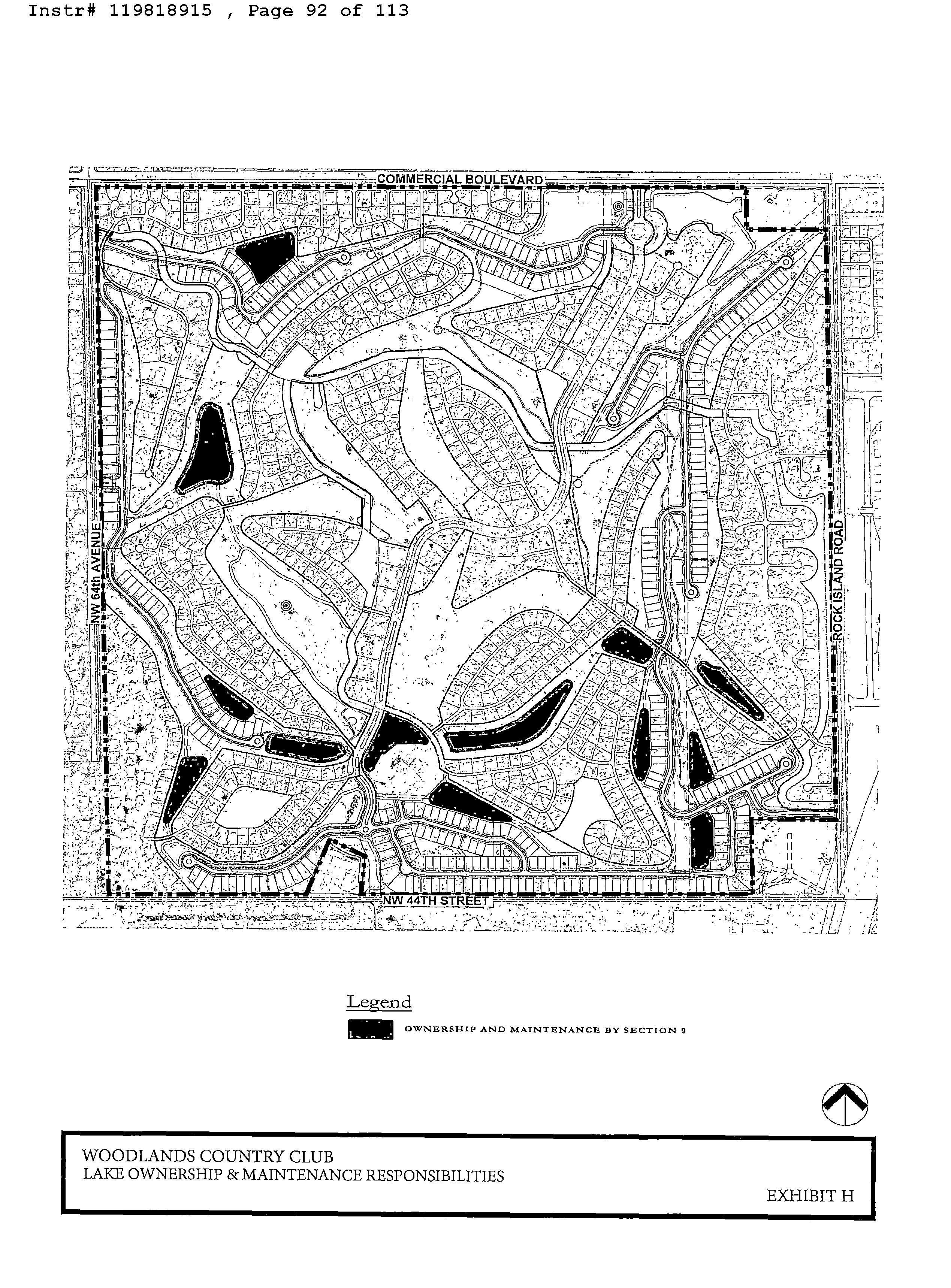
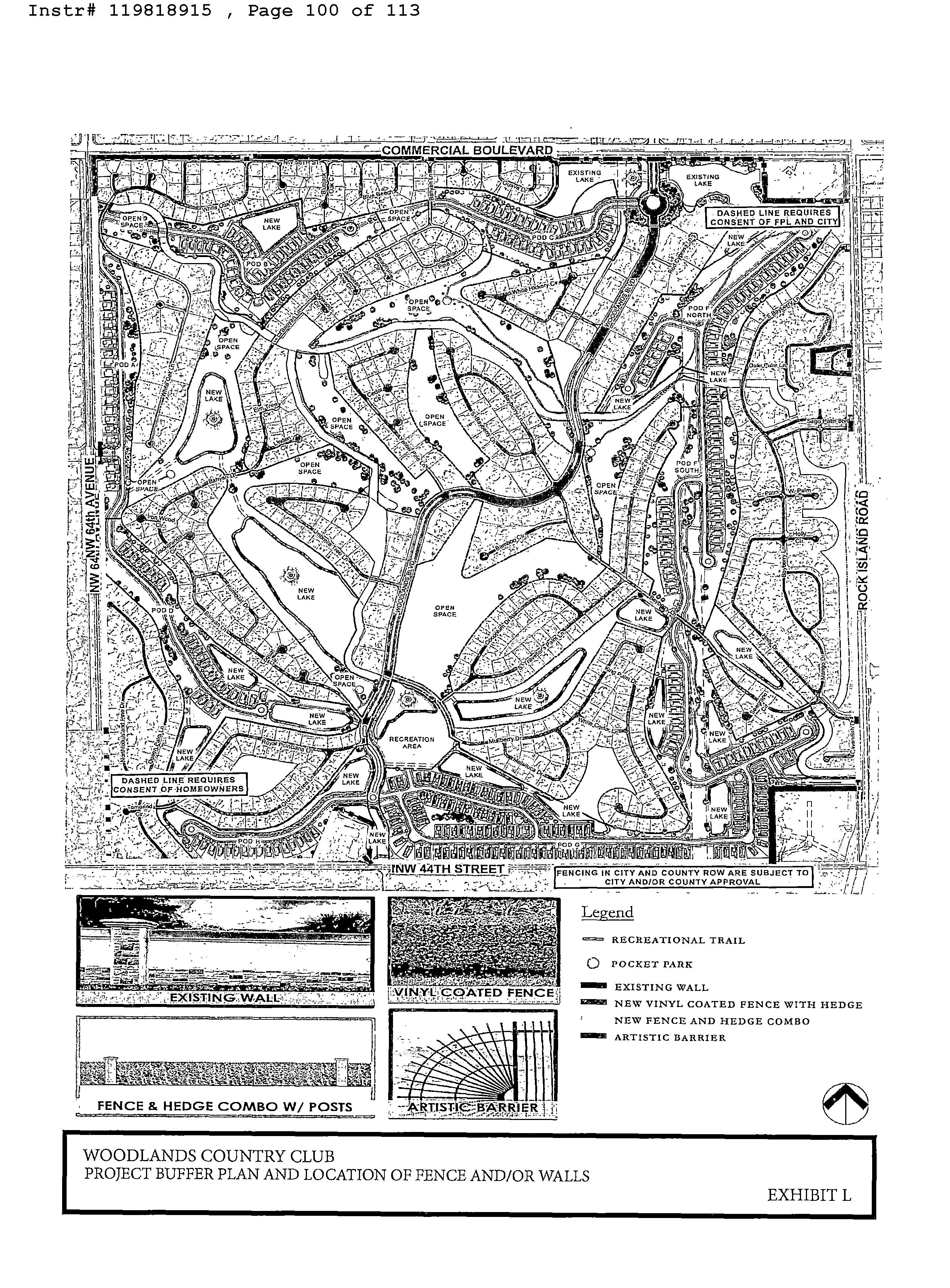
16. Project Buffers. The Developer shall install a mix of lakes, landscape buffers, buffer walls/ fencing and Open Space within and around the Residential Pods and Woodlands Community as identified on Exhibit "L", attached hereto and more specifically described below:
a) Lakes: A portion of the Property consists of certain waterways which were previously dedicated to the City by plat when the Property was initially developed Waterway Areas"). The Site Plan contemplates filling in portions ofthe Waterway Areas for development of the Residential Pods and Open Space. The Site Plan also contemplates expanding portions of the existing Waterway Areas and creating new waterway areas as identified in Exhibit " M" (" New Waterway Areas"). Filling in portions of the existing Waterway Areas and creating New Waterway Areas shall be constructed at the sole costs
and expense of the Developer. As built surveys ofthe New Waterway Areas, as modified through the site planning, surveying and permitting process, will be prepared, and provided to the City upon completion of the New Waterway Areas for review and approval. Sketch and legal descriptions of the locations of the Waterway Areas, New Waterway Areas, and necessary Lake Maintenance Easements shall be prepared by Developer. Developer shall convey the New Waterway Areas by warranty deed, and Lake Maintenance Easements that are contiguous to the existing Waterway Areas, or filled in as part ofthe Project, to the City as they are completed and certified during development of the Residential Pods. Such conveyance is to occur no later than the issuance of the first Certificate of Occupancy for a residential unit within the associated phase ofresidential development, excluding model homes. Section 9 shall be responsible, through a Lake Maintenance Agreement to reimburse the City at an initial cost of TWENTY FIVE THOUSAND DOLLARS
25 000.00) annually for the New Waterway Areas that are contiguous to City owned Waterway Areas (" Lake Maintenance Fee"). The Lake Maintenance Fee shall escalate year over year by the annual Consumer Price Index (" CPI"). All Waterway Areas not contiguous to City owned Waterway Areas shall be owned and maintained by Section 9. Lake Maintenance Easements shall be provided for all existing and proposed Waterway Areas, except in instances where existing lakes are abutting existing private residential properties. The governing documents for Section 9 will include a restriction on fishing, boating, and any other recreational and commercial activities, in all lakes within the Project. Lakes shall be excavated to a depth required by the City, County, SFWMD or any other applicable government or regulatory agencies necessary to ensure all drainage and stormwater runoff will be managed in accordance with applicable regulations. Developer
shall also install water features in certain existing and new lakes, such as fountains, maintenance equipment access ramps, or other elements meant to keep the water bodies from becoming stagnant. Developer shall work with City Engineering staff during the site plan review process to confirm the appropriate number of aeration devices and maintenance equipment access ramps within the Waterway Areas and New Waterways Areas. Section 9 shall be responsible for, at its sole cost and expense, the maintenance of fountains or other elements associated with those Lakes within the Project as identified in Exhibit " H".
b) Landscape Buffers: Developer shall install landscape buffers generally consistent with the conceptual plans identified on the landscape plans approved by the City as part of the Site Plan Application -(" Landscape Buffers"). Landscape Buffers may include lakes, open space, berms, trees and other appropriate landscape and/ or decorative features ( such as fences, fountains and other features). Prior to the commencement ofvertical construction within any Pod ( except for any model homes), Developer shall commence installation of the landscape buffer around the perimeter of such Pod in areas where there are existing homes adjacent to the Residential Pod. No vertical construction for new residential units except for model homes) may start prior to commencing installation of an adjacent Landscape Buffer. Nothing in this Paragraph shall prevent Developer from obtaining land development permits or model home permits and commencing land development activity or construction of model homes for the Project.
c) Perimeter Buffer: Developer shall install, to the extent possible, fences and/ or walls along the perimeter of the Woodlands Community in the locations noted in Exhibit " L". Specifically, Developer agrees that it shall be responsible for design and construction of
perimeter landscaping and buffer wall/ fence improvements, consistent with the location and details provided in Exhibit " L", subject to the review and approval from appropriate governmental and regulatory agencies and utility providers including but not limited to the City, County and the Florida Department of Transportation (" FAOT" ), FP& L and other utility providers, as applicable. Developer shall submit any and all plans, applications, permits or other documents required by the City necessary to construct the new buffer walls, fences or other improvements noted on Exhibit " L". There are approximately sixteen ( 16) privately owned residential lots that will need to consent to the proposed buffers being placed on their private property, as further identified on Exhibit " U. Developer shall use good faith efforts to notify and contact each applicable private property owner in an effort to secure the necessary consent and authorization to construct the buffer improvements. The City acknowledges that the installation ofthe proposed buffers within these parcels is subject to consent of the private property owners. In addition to the above, prior to the issuance ofthe first building permit for construction ofthe first residential unit on the Property ( excluding model homes), Developer agrees to contribute Four Hundred Seventy Two Dollars ($472. 00) per linear foot ofwall up to a maximum of Three Hundred and Forty Four Thousand Five Hundred Sixty and 00/ 100 Dollars ($ 344, 560. 00) to be used at the City' s discretion for construction of buffer wall improvements, consistent with the City' s standard wall design, for the single-family homes within Mainlands Section 6 along the east side of Rock Island Road for approximately seven hundred and thirty linear feet 730') from the northern property line of the single- family lot on the north side of NW 551b Court to the southern property line of the single- family lot on the south side of NW 53rd Street, excluding the right-of-way connection points used for vehicular ingress and/ or
caress. Developer further agrees to contribute an additional Four Hundred Seventy -Two and 00/ 100 Dollars ($ 472. 00) per linear foot to the City, to be used for construction of buffer wall improvements, consistent with the City' s standard wall design, for approximately five hundred feet ( 500') on the north side of Commercial Boulevard, west of Rock Island Road, excluding any right-of-way connection points used for vehicular ingress and/ or egress.
d) NW 641h Avenue: In the event there is access to the Project from NW 64th Avenue, Developer shall install a functional local right of way, consistent with City and County roadway standards, to include appropriate infrastructure to connect the Project to NW 641h Avenue. The improvements shall include sufficient landscaping adjacent to the newly constructed NW 641h Avenue buffer wall/fence consistent with Exhibit " U. Developer shall submit any and all plans, applications, permits or other documents required by the City and/or any other governmental agency necessary to construct the new roadway New Roadway").
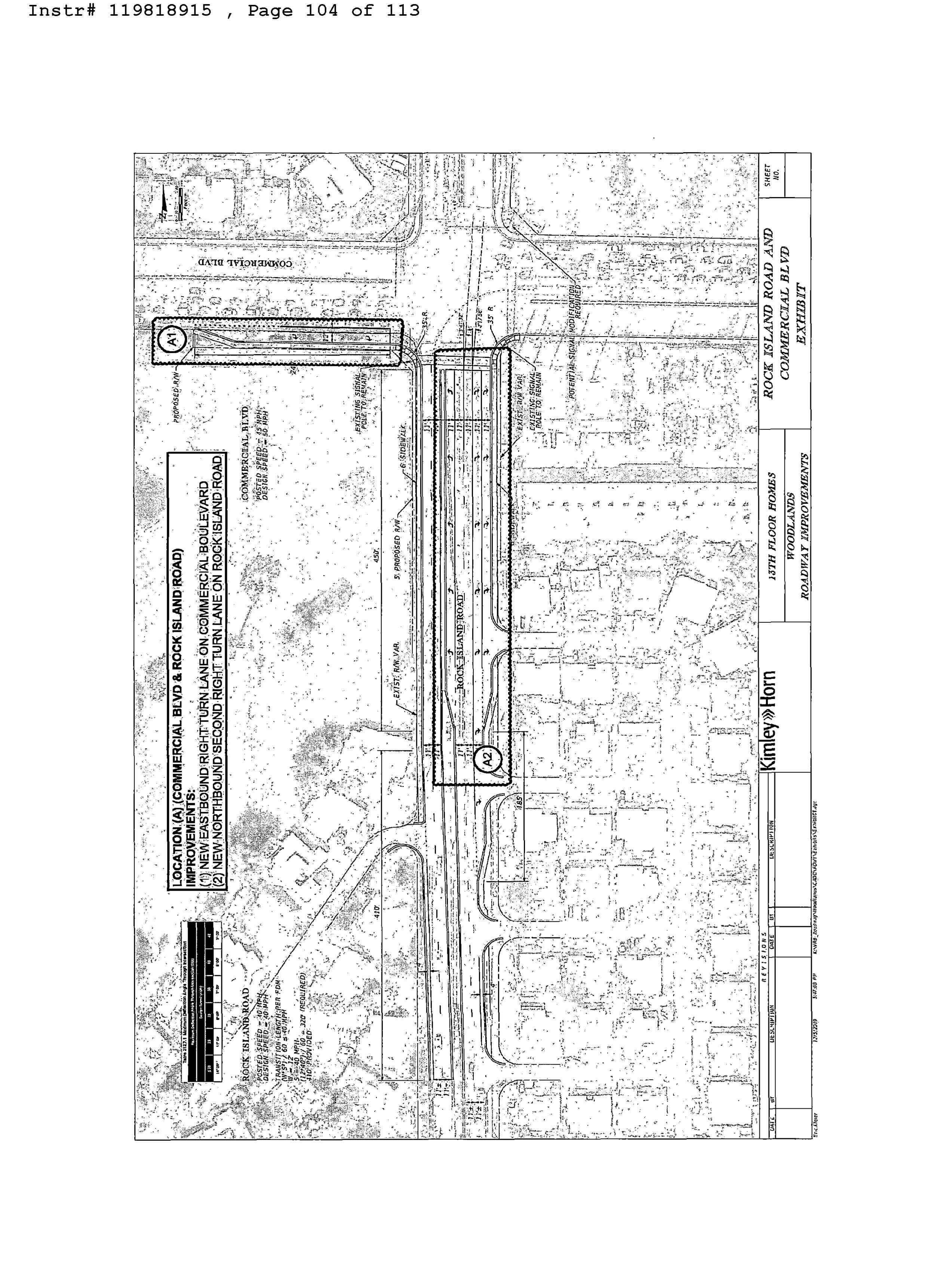
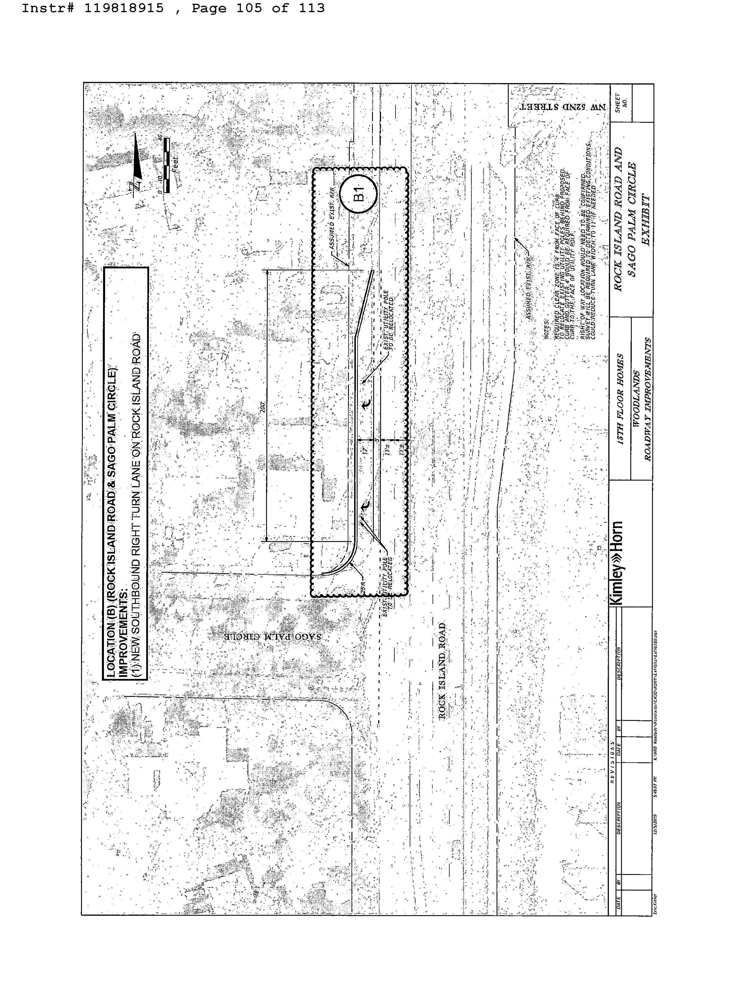
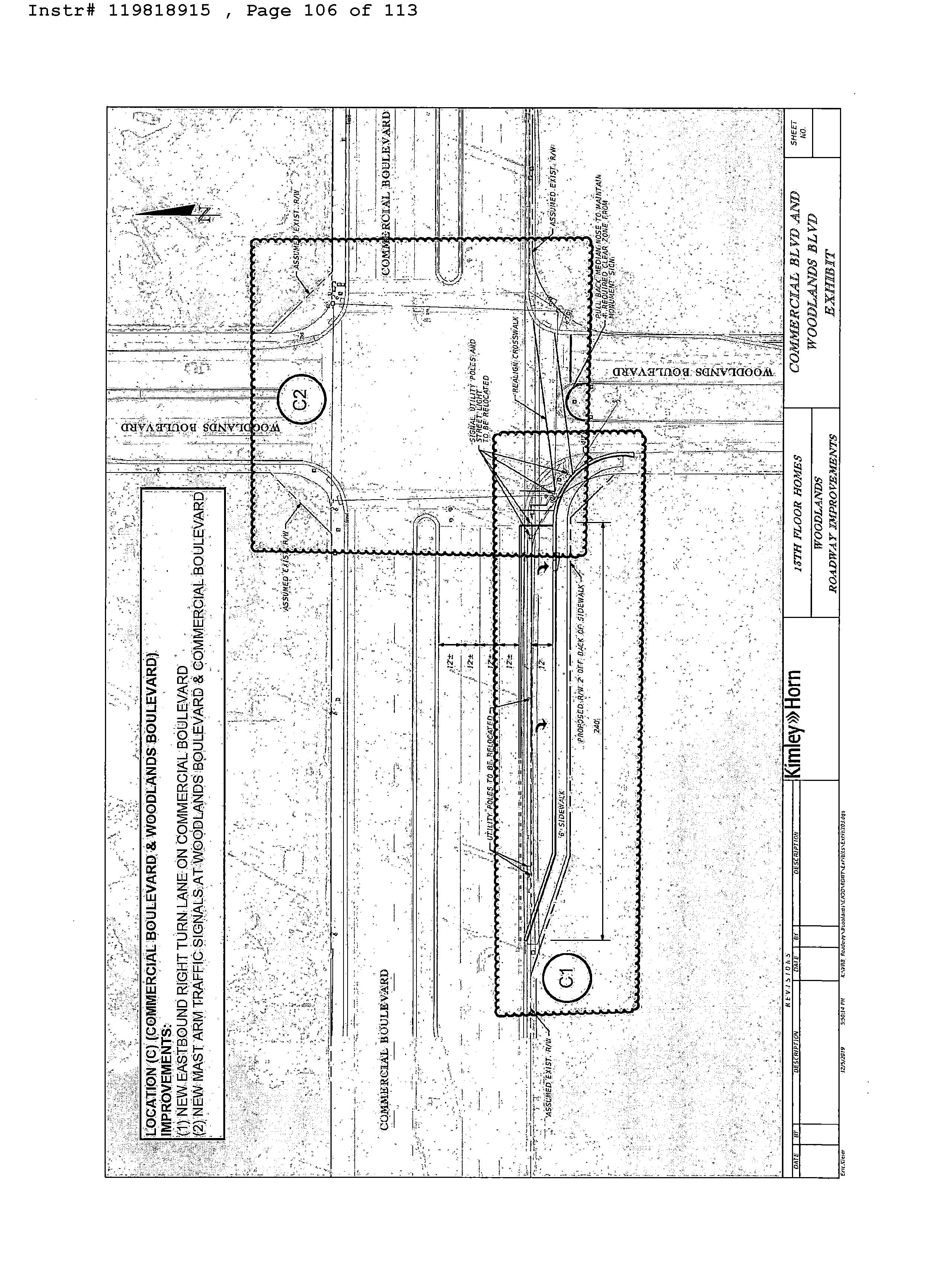
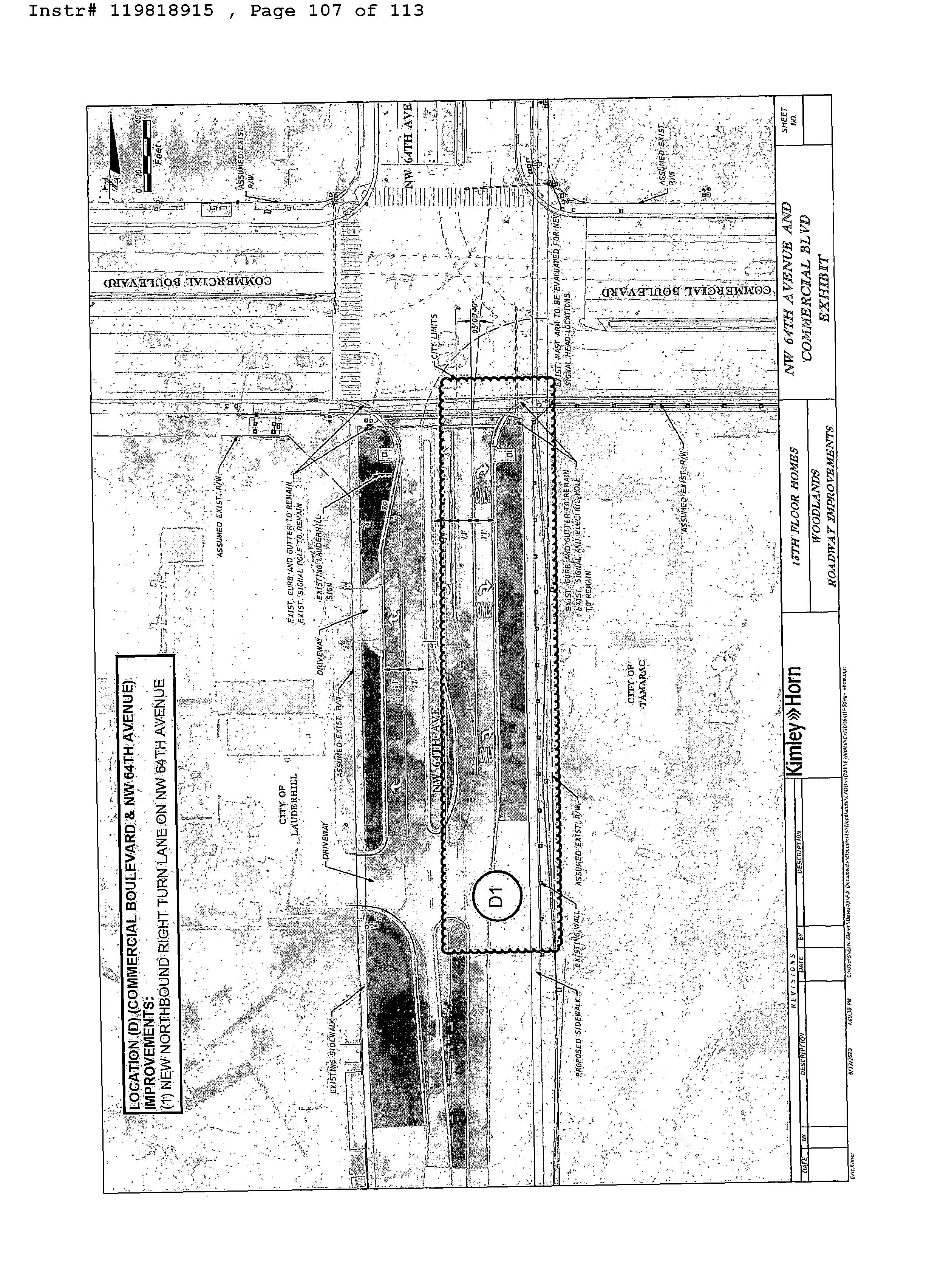
17. Offsite Improvements: Developer shall, to the extent possible, construct the improvements to adjacent rights -of -ways, including turn -lanes, curbing, median modifications, sidewalks, buffer walls/ fences, gates, landscaping, and other related improvements as further identified on the proposed conceptual off -site improvement plan attached hereto as Exhibit "N" collectively, the " OffSite improvements""). Developer shall submit any and all plans, applications, permits or other documents required by the City and/ or any other governmental agency necessary to construct the Off -Site Improvements, including but not limited to the County and FDOT. The City shall fully cooperate with Developer in obtaining all approvals necessary to construct the Public Facilities, OffSite Improvements, the Roadway Improvements, and the New
Roadway, including providing and executing any documents, applications, plans, and submittals that are reasonably required to be executed by the City in connection with the foregoing. Developer further acknowledges that the City owns the east half of the NW 64`h Avenue right- ofway adjacent to the Property, and the west half ofthe NW 64th Avenue right-of-way is owned by the City ofLauderhill. Developer shall, to the extent possible, construct the improvements to the NW 64"' Avenue right-of-way, as identified in Exhibit "N", including turn -lanes, curbing, median modification, landscaping and other related improvements, and will obtain all required pennits for the completion of such improvements.
In addition, FDOT is currently undertaking a joint -funded project ( FM# 41944) with the County to design and construct an Adaptive Traffic Signal Control System, Arterial Dynamic Message Signs (" ADMSs"), Bluetooth detectors, Closed Circuit Television (" CCTV") cameras, traffic/ vehicle detector upgrades and fiber optic infrastructure upgrades and expansion along Commercial Boulevard from Rock Island Road to Federal Highway. FDOT Project FM# 441944 is programmed in the FDOT adopted Five Year Work Program for implementation during Fiscal Year 2024. In satisfaction ofFDOT' s comment for the proposed City of Tamarac Comprehensive Plan Amendment with the Department of Economic Opportunity (" DEO"), Developer shall contribute ONE HUNDRED FOURTEEN THOUSAND NINE HUNDRED SIXTY FOUR
DOLLARS ($ 114, 964. 00) to the City for payment to FDOT for Project FM#441944 as a proportionate share contribution related to the traffic impacts resulting from the Project. The Developer agrees that, providing the LUPA and Rezoning have been approved and all applicable appeal periods have expired, it shall, within twenty ( 20) days of the execution of the State of Florida Department of Transportation Locally Funded Agreement between the City and FDOT, furnish the City with the payment of $114,964.00 for the City' s payment to FDOT. 00363603.
18. Construction Management: Developer shall use commercially reasonable efforts to ensure minimal impact and disruption on the Woodlands Community during construction. Prior to issuance of a building permit, Developer shall provide the City with a construction management plan which includes details related to the proposed construction of the Project, including construction work hours, right- of-way closure plans, loading plans, and contact information for a construction liaison. The construction liaison shall meet with the community as needed and be responsive to email and phone inquiries from the City and residents related to construction activities for the Project. Developer further agrees to contribute ONE HUNDRED SEVENTY EIGHT THOUSAND FOUR HUNDRED DOLLARS ($ 178, 400. 00), equating to TWO HUNDRED DOLLARS ($ 200.00) per existing home to the City for establishing a community enhancement fund for assistance in cleaning and/or maintaining existing homes and vehicles within the Woodlands Community that may be impacted by construction activities. Said payments shall be made to the City prior to the issuance ofthe first building permit for construction of the first residential unit for the Project. Should any burrowing owls, or other endangered or protected species be discovered during the course of construction, Developer shall comply with all applicable State and Federal regulations related to the relocation of such animals.
19. Affordable Housing Contribution. Developer hereby agrees to contribute TWO THOUSAND DOLLARS ($ 2,000.00) per residential dwelling unit approved by the City during final site plan approval ofall Residential Pods (by way ofexample only, approval ofthree hundred and thirty five ( 335) single- family residential dwelling units would yield a maximum total sum of SIX HUNDRED AND SEVENTY THOUSAND DOLLARS ($ 670,000.00), payable to the City to facilitate the City' s affordable housing programs and initiatives with the contribution to be used
to provide down payment assistance to income eligible families for purchase of residential units throughout the City. Said contribution will be made payable to the City and spread proportionately on a per residential dwelling unit basis, the first such contribution to be made at issuance of the first vertical building permit for any residential dwelling unit located within the Residential Pods, and each time thereafter as abuilding permit is issued for each successive residential dwelling unit. In addition, Developer shall contribute ONE HUNDRED TWENTY THOUSAND DOLLARS
120, 000. 00) to the City' s rental assistance strategy program, to be allocated for residents of Tamarac. Said payments shall be made to the City prior to the issuance ofthe first building permit for construction of the first residential unit for the Project ( excluding model homes).
20. Woodlands Overlay District. The Woodlands Overlay District (" WOD") currently provides for the creation and establishment of specific regulations in addition to those requirements contained within the City LDC that will serve to preserve the neighborhood character, promote its high quality and appearance, maintain property values and protect the public health, safety and welfare. Additionally, the WOD is not only intended to provide guidelines to ensure the preservation ofthe Woodlands Community' s visual integrity, but to also ensure that every property is maintained in accordance with the community standards. The WOD is set to expire on July 12, 2025, due to the adoption of the City' s new LDC. The Woodlands Community has expressed concern over losing the aesthetic and architectural controls established by the WOD. As such, Developer and the City shall establish the cost and an enforcement structure no later than January 2025, to be funded by Section 9 for a City Code Enforcement Officer to enforce the following standards that have been established in Section 10- 2.7 ( C), of the City of Tamarac Code of Ordinances, entitled " Woodlands Overlay District" for the WOD:
a) All standards as outlined in Section 10- 2. 7 ( C) entitled " Woodlands Overlay District" are adopted herein by reference .
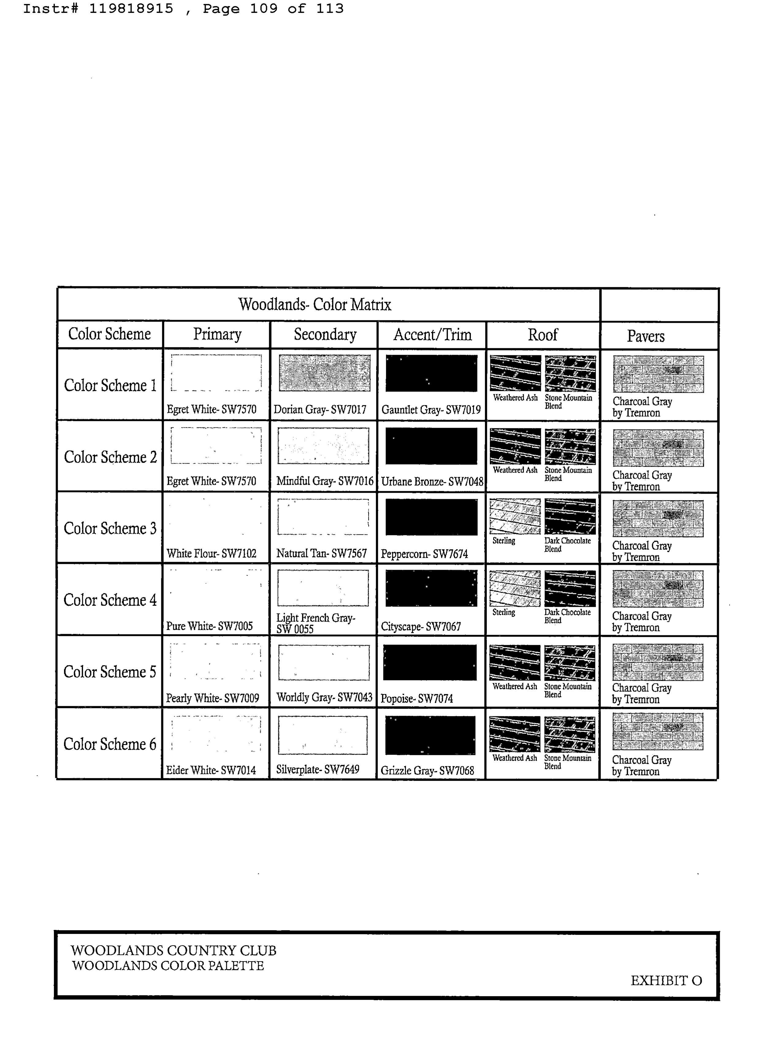
b) The established color scheme referred to as the " Woodlands Color Palette" shall be maintained for all single- family homes. A copy of the Woodlands Color Palette is attached hereto as Exhibit "N".
These standards shall also be included in the governing documents for Section 9 to ensure that they survive the term of this Agreement.
21. Additional Community Benefits:
a) Developer shall contribute TWO HUNDRED AND FIFTY THOUSAND DOLLARS ($ 250, 00. 00) towards the City' s beautification program and the implementation ofthe City' s Landscape Master Plan. Said payments shall be made to the City within thirty (30) days following expiration of the appeal period for approval of all Application for the Project.
b) Developer shall contribute SEVEN HUNDRED AND FIFTY THOUSAND DOLLARS ($ 750,000.00) to the City for use towards the improvements associated with the proposed Shaker Village / East Side Community Center (" Community Center"), or any new community center to be developed by the City, generally located east of NW 641h Avenue, that will offer various activities and rooms for use by residents of the City. Any fees paid towards the Community Center shall be creditable towards the City' s Parks and Recreation impact fee. Said payments shall be made to the City within thirty ( 30) days following expiration of the appeal period for approval of all Application for the Project.
c) Developer acknowledges there may be impacts in and outside of the existing Woodlands Community and agrees to contribute NINE HUNDRED TWENTY FIVE THOUSAND DOLLARS ($ 925, 000.00) directly to the City for distribution to various homeowner associations which may be impacted by the development of the Project. Said payments shall be made directly to the City within thirty (30) days following expiration of the appeal period for approval of all Applications for the Project.
d) Developer shall provide various charitable donations totaling TWO HUNDRED AND FIFTY THOUSAND DOLLARS ($ 250,000.00) towards the following charities, as follows: The Broward Outreach Centers ($ 75, 000. 00); Rapha Center Inc 25, 000. 00); the Tamarac Cougars ($ 25, 000. 00); the Tamarac Chamber of Commerce 25, 000. 00); Women in Distress ($ 25, 000.00); Dare to Care ($ 25, 000. 00); Discover the Beauty ($ 25,000.00); and Kiwanis Tamarac Foundation ($ 25, 000. 00). Said payments shall be made directly to the various charitable organizations with proof of payment presented to the City within thirty (30) days following expiration of the appeal period for approval of all Applications for the Project.
e) Small Business Contracting Goals: The City of Tamarac is responsive to its vendor community, and to local Tamarac, Small Business Broward County, and Veteran -owned businesses. For all design and construction activity related to the Project, Developer is strongly encouraged to contract with Local Tamarac Vendors, firms certified by the Broward County Office of Economic and Small Business Development (" OESBD") as a Broward County Certified Small Business Vendor / Certified Business Entity (" CBE"), and Veteran - Owned Small
Businesses as defined in 38 CFR § 74. 1, as amended.
f) Smart Neighborhood Initiatives: In an effort to optimize the efficiency of City operations and services and connect to the citizens of the Woodlands Community and the Project, Developer agrees to make available upon request the following physical devices: Smart Lighting ( LED) Fixtures; Hotspots; License Plate Readers at Entrance Points; Automated Meter Reading System Enabled Water Meters. Other than providing applicable information upon request, Developer shall have no additional obligations to pay for or install any of the items noted above.
22. Developer Contributions and Impact Fee Credits. Unless otherwise required by the City' s LDC, payments and contributions noted herein that are associated with applicable City impact fees shall be impact fee creditable, as permitted under Section 10- 5. 7(F) ofthe City' s LDC. Unless otherwise noted herein, all Impact Fee related payments shall be made to the City within At the issuance ofbuilding permits related to each phase ofthe project.
23. Effective Covenants. The benefits and burdens of this Agreement shall run with the land and shall be binding upon the Developer, the City, and all successors in interest of the parties to this Agreement.
24. Development Approvals. Developer will apply for all development approvals that are required by the State of Florida, Broward County, the City and any other applicable governmental authority, including but not limited to those specific approvals more particularly set forth on Exhibit " P", attached hereto and made a part hereof. Developer and City agree that the failure of this Agreement to address a particular permit, condition, term or restriction shall not relieve Developer of the necessity of complying with the law governing said permitting requirements, conditions, terms or restrictions. All obligations herein are expressly contingent on
any necessary approvals and permits issued by applicable governmental agencies, districts and/or service providers ( County, drainage districts, FPL, etc.).
25. Duration of Agreement. This Agreement shall remain in full force and effect for a period often ( 10) years from the Effective Date. The duration ofthe Agreement may be extended for additional one ( 1) year periods with the Parties' mutual written consent, or the mutual written consent of their successors in interest, in accordance with Section 163. 3229 and Section 163. 3225, Florida Statutes, which extension must be recorded in the Public Records of Broward County, Florida to be effective. Any applicable extensions otherwise authorized by State Statutes shall also be applicable to the timeframes established by this Agreement. The provisions of Paragraph 19 shall survive the ten ( 10) year duration of the Agreement.
26. Recording. This Agreement shall be recorded in the Public Records of Broward County within fourteen ( 14) days after execution by the Parties at Developer' s cost.
27. Effective Date. This Agreement shall become effective upon proper recordation in the public records ofBroward County, and upon the effective date of the Application approvals, including expiration of all appeal periods.
28. Periodic Review. In accordance with Section 163. 3235, F. S., as may be amended from time to time, the City' s Department of Community Development shall review the property subject to this Agreement at least once every twelve ( 12) months to determine if there has been demonstrated good faith compliance with the terms set forth herein. If the City finds, on the basis of competent substantial evidence, that there has been a failure to comply with the terms of this Agreement, the Agreement may be revoked or modified by the City Commission. In the event of a failure to comply with the terms of this Agreement, Developer shall have the right to notice, the
opportunity to be heard, and a reasonable opportunity to cure such noncompliance before the Agreement is revoked or modified.
29. Miscellaneous.
1) Entire Agreement. This Agreement sets forth all of the promises, covenants, agreements, conditions and understandings between the Parties, and supersedes all prior and contemporaneous agreements, understandings, inducements or conditions, express or implied, oral or written, except as herein contained. The City shall not request any additional improvements or contributions except for those required by the State ofFlorida, Broward County, City and any other applicable governmental authority, or expressly set forth in this Agreement.
2) Modification. No modification of this Agreement shall be valid or binding unless such modification is in writing, duly dated and signed by the Parties, or their respective successors in interest, and is in compliance with Section 163. 3225, Florida Statutes.
3) Pronouns. All pronouns and any variations thereofshall be deemed to refer to the masculine, feminine and neuter, singular or plural, as the identity of the party or parties, personal representatives, successor or assigns may require.
4) Severability. The invalidity of any provision hereof shall in no way affect or invalidate the remainder of the Agreement.
5) Counterparts. This Agreement may be executed in one or more counterparts, each of which shall be deemed an original, but all of which shall together constitute one in the same instrument.
6) Governing Law. This Agreement shall be construed in accordance with the laws of the State of Florida, and any proceeding arising between the Parties in any manner
pertaining to this Agreement shall, to the extent permitted by law, be held in Broward County, Florida.
7) BindingE. The obligations imposed pursuant to this Agreement upon Developer and/or upon the Property run with and bind the Property as covenants running with the Property and this Agreement shall be binding upon and enforceable by and against the parties hereto, their personal representatives, heirs, successors, grantees, mortgagees and assigns. This Developer' s Agreement shall survive the foreclosure of any mortgage now or hereafter placed upon all or part of the Property. Without limiting the foregoing, Developer may not assign ( in whole or in part) all or any portion of Developer' s rights and obligations under this Agreement in connection with any sale or other transfer of a Pod. Developer shall not assign any portion of the entitlements for the Project unless and until Developer shall first obtain the City' s written consent, which consent shall not be unreasonably withheld but may be conditioned upon such assignee having financial resources that are comparable to or more substantial than those of the Developer and shall complete the Project subject to this Development Agreement. After such assignment and assumption, Developer will have no further obligation or liability under this Development Agreement with respect to the transferred Pod except for any unperformed obligations that arose before the assignment (unless assumed in writing by the assignee).
8) Attorneys' Fees. Should either party hereto bring an action against the other to enforce the terms and provisions hereof,then the party prevailing in said action shall be entitled to a judgement against the other for reasonable attorneys' fees and costs at both the trial and appellate levels.
9) Further Assurances. City shall use best efforts to, from time to time at the request of Developer, without any additional consideration, furnish the Developer such further
information or assurances, execute and deliver such additional documents, instruments, and conveyances, and take such other actions and do such other things, as may be reasonably necessary or desirable to carry out the provisions of this Agreement, the permitting, construction and development of the Project, and give effect to the transactions contemplated hereby.
Remainder of Page Intentionally Left Blank]
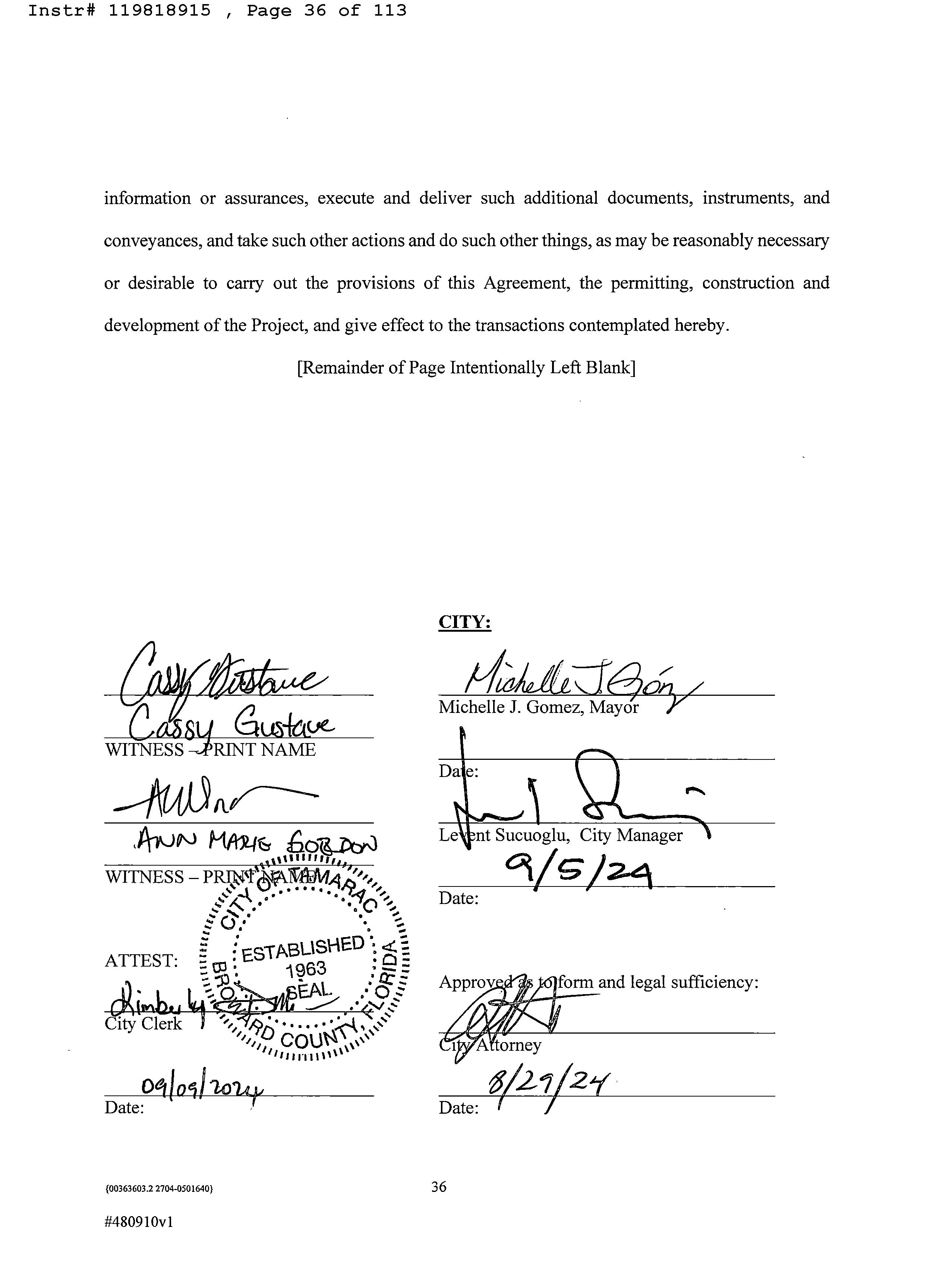
CITY:
Michelle J. Gomez, Mayor
Notary Blocks and Signatures on Following Page]
100363603.2 2704-0501640}
STATE OF FLORIDA )
COUNTY OF BROWARD)
ss:
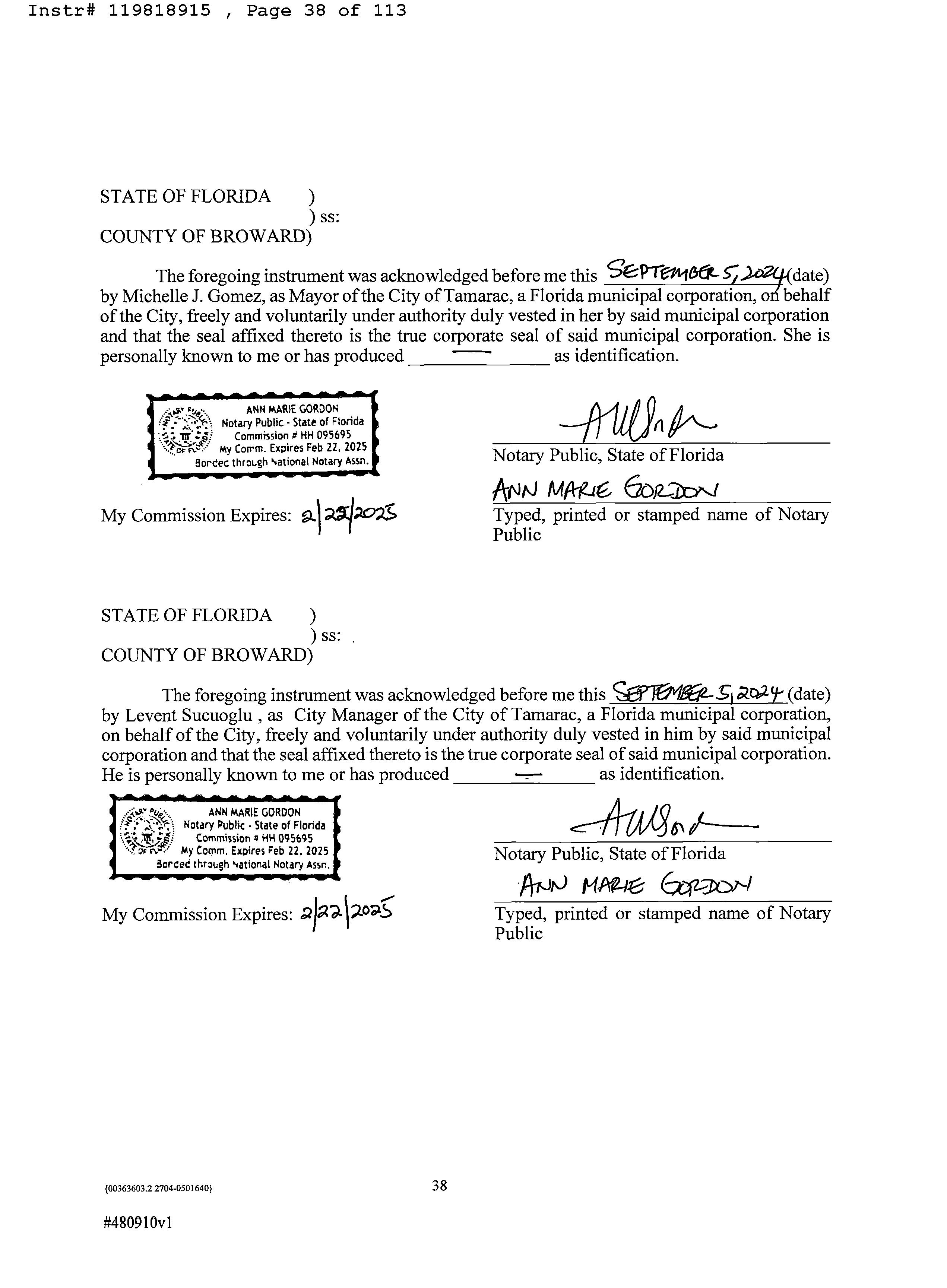
The foregoing instrument was acknowledged before me this S'CPTG- 106LSedate) by Michelle J. Gomez, as Mayor ofthe City ofTamarac, a Florida municipal corporation, orl behalf ofthe City, freely and voluntarily under authority duly vested in her by said municipal corporation and that the seal affixed thereto is the true corporate seal of said municipal corporation. She is personally known to me or has produced as identification. w;. R•,
MARIE GORDON Notary Public . State of Florida Commission # HH 095695 f -' My Corrm. Expires Feb 22, 2025 5ordec through rational Notary Assn. My Commission Expires: 9.1 Acz
STATE OF FLORIDA )
COUNTY OF BROWARD) n Notary Public, State of Florida ANN MA-g,,' 6DR-2c)?' i
ss:
Typed, printed or stamped name of Notary Public
The foregoing instrument was acknowledged before me this Sffr6vh5 any-(date) by Levent Sucuoglu,as City Manager of theCity of Tamarac,a Florida municipal corporation, on behalf of the City, freely and voluntarily under authority duly vested in him by said municipal corporation and that the seal affixed thereto is the true corporate seal of said municipal corporation. He is personally known to me or has produced as identification. da
Public, State of Florida ANrJMAC(-02- 3c-r1 Typed, printed or stamped name of Notary Public 9480910vl
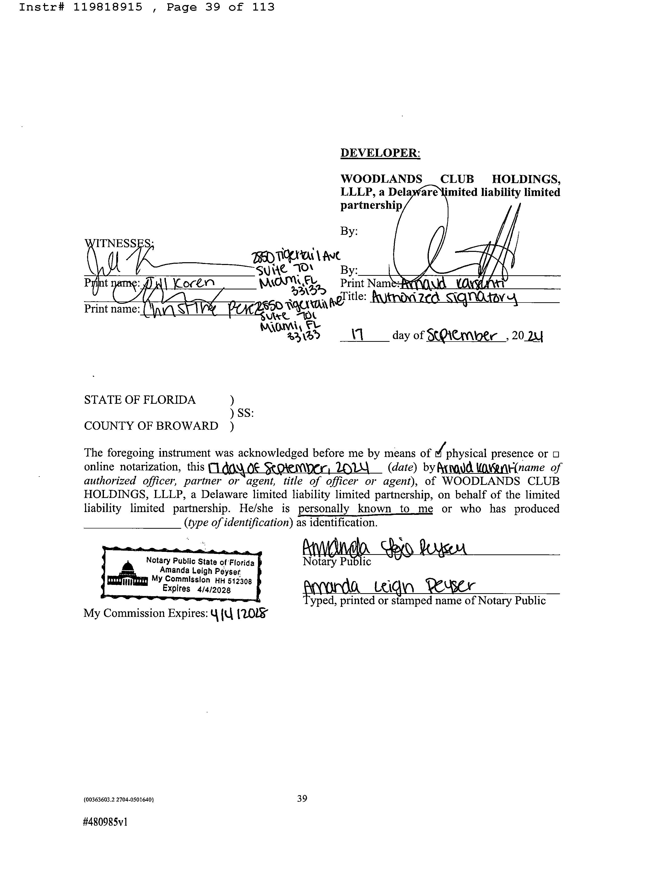
DEVELOPER:
WOODLANDS CLUB HOLDINGS, LLLP, a Dela are ' mited liability limited partnership / 9 By:
STATE OF FLORIDA ) SS:
COUNTY OF BROWARD )
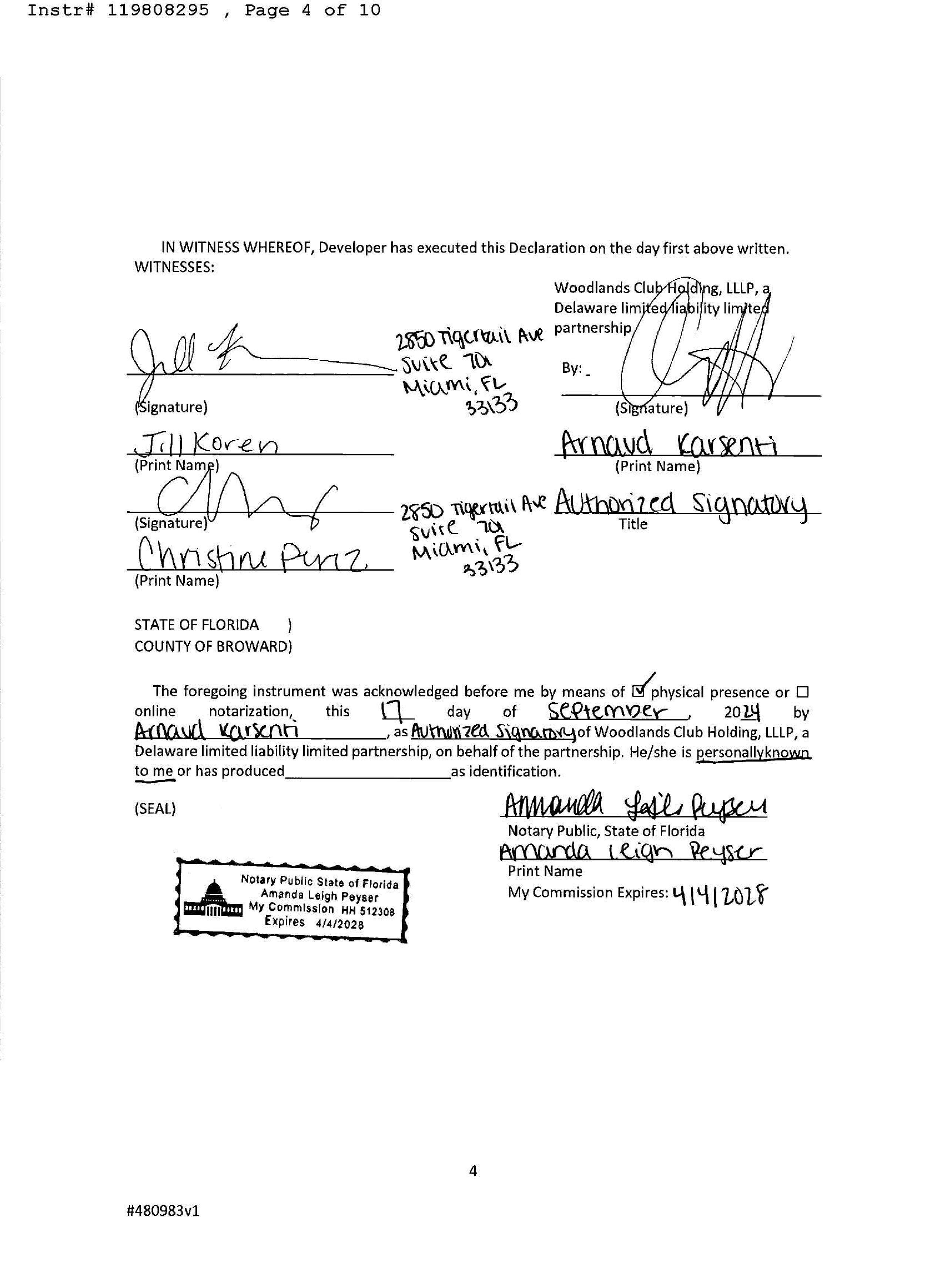
The foregoing instrument was acknowledged before me by means of d physical presence or online notarization, this n dM OF 5 Wi- d ify aA ( date) by PJd V&% 9 Kname of authorized officer, partner or agent, title of officer or agent), of WOODLANDS CLUB HOLDINGS, LLLP, a Delaware limited liability limited partnership, on behalf of the limited liability limited partnership. He/ she is personally known to me or who has produced type of identification)as identification. Notary
LIST OF EXHIBITS
EXHIBIT " A" - LEGAL DESCRIPTION FOR 276 ACRE PROPERTY
EXHIBIT " B" - CONCEPTUAL PLAN
EXHIBIT " C" - CONCEPTUAL RESIDENTIAL ELEVATIONS
EXHIBIT " D" - CONCEPTUAL LAYOT OF RECREATION POD
EXHIBIT " E" - LEGAL DESCRIPTION OF 165 ACRE PROPERTY SUBJECT TO LUPA AND
REZONING
EXHIBIT " F" - OPEN SPACE PLAN
EXHIBIT " G" - FORM DECLARATION OF RESTRICTIVE COVENANTS
EXHIBIT " H" - LAKE OWNERSHIP & MAINTENANCE RESPONSIBILITIES
EXHIBIT " I" - LOCATION OF EXISTING AND PROPOSED NEW ROADWAYS WITHIN
WOODLANDS, LOCATION OF MAIN AND SECONDARY GATES, AND PHASING PLAN FOR NEW ENTRANCES
EXHIBIT " J" - INSURNACE AND INDEMNIFICATION REQUIREMENTS
EXHIBIT " K" - CONCEPTUAL GRAPHIC OF MAIN GATE
EXHIBIT " L" - PROJECT BUFFER PLAN AND LOCATION OF FENCES AND/ OR WALLS
EXHIBIT " M" - LOCATION OF NEW AND EXISTING LAKES
EXHIBIT " N" - CONCEPTUAL OFFSITE IMPROVEMENTS
EXHIBIT " O" - WOODLANDS COLOR PALETTE
EXHIBIT " P" - LIST OF DEVELOPMENT APPROVALS REQUIRED FOR PROJECT
EXHIBIT " Q" - PEDESTRIAN CONNECTIVITY PLAN
Exhibit 'FAR'
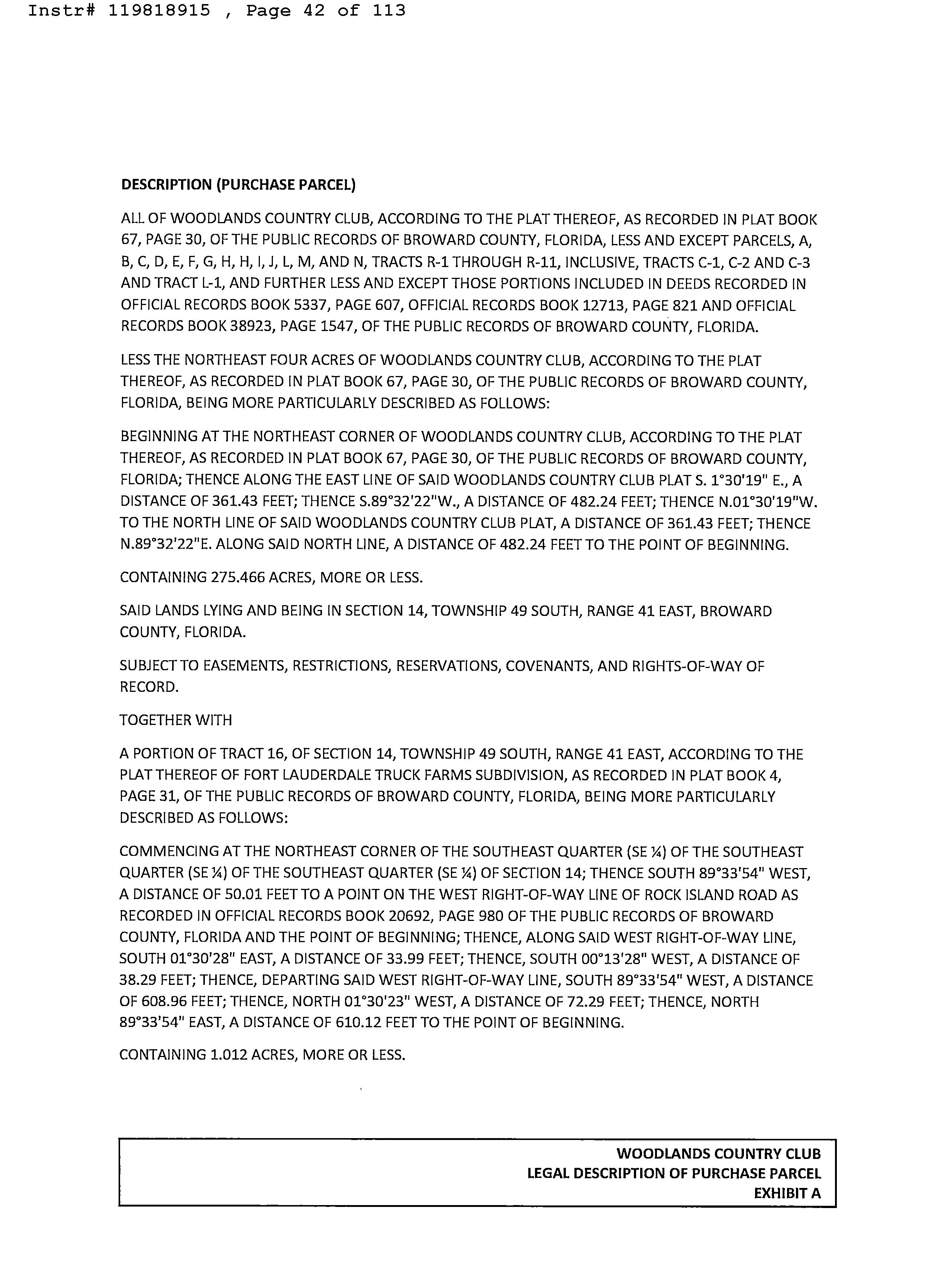
DESCRIPTION ( PURCHASE PARCEL)
ALL OF WOODLANDS COUNTRY CLUB, ACCORDING TO THE PLAT THEREOF, AS RECORDED IN PLAT BOOK 67, PAGE 30, OF THE PUBLIC RECORDS OF BROWARD COUNTY, FLORIDA, LESS AND EXCEPT PARCELS, A, B, C, D, E, F, G, H, H, I, J, L, M, AND N, TRACTS R- 1 THROUGH R- 11, INCLUSIVE, TRACTS C- 1, C- 2 AND C- 3 AND TRACT L- 1, AND FURTHER LESS AND EXCEPT THOSE PORTIONS INCLUDED IN DEEDS RECORDED IN OFFICIAL RECORDS BOOK 5337, PAGE 607, OFFICIAL RECORDS BOOK 12713, PAGE 821 AND OFFICIAL RECORDS BOOK 38923, PAGE 1547, OF THE PUBLIC RECORDS OF BROWARD COUNTY, FLORIDA.
LESS THE NORTHEAST FOUR ACRES OF WOODLANDS COUNTRY CLUB, ACCORDING TO THE PLAT THEREOF, AS RECORDED IN PLAT BOOK 67, PAGE 30, OF THE PUBLIC RECORDS OF BROWARD COUNTY, FLORIDA, BEING MORE PARTICULARLY DESCRIBED AS FOLLOWS:
BEGINNING AT THE NORTHEAST CORNER OF WOODLANDS COUNTRY CLUB, ACCORDING TO THE PLAT THEREOF, AS RECORDED IN PLAT BOOK 67, PAGE 30, OF THE PUBLIC RECORDS OF BROWARD COUNTY, FLORIDA; THENCE ALONG THE EAST LINE OF SAID WOODLANDS COUNTRY CLUB PLAT S. 1° 30' 19" E., A DISTANCE OF 361. 43 FEET; THENCE 5. 89* 32' 22" W., A DISTANCE OF 482. 24 FEET; THENCE N. 01* 30' 19" W. TO THE NORTH LINE OF SAID WOODLANDS COUNTRY CLUB PLAT, A DISTANCE OF 361.43 FEET; THENCE N. 89°32' 22" E. ALONG SAID NORTH LINE, A DISTANCE OF 482. 24 FEETTO THE POINT OF BEGINNING.
CONTAINING 275. 466 ACRES, MORE OR LESS.
SAID LANDS LYING AND BEING IN SECTION 14, TOWNSHIP 49 SOUTH, RANGE 41 EAST, BROWARD COUNTY, FLORIDA.
SUBJECTTO EASEMENTS, RESTRICTIONS, RESERVATIONS, COVENANTS, AND RIGHTS -OF -WAY OF RECORD.
TOGETHER WITH
A PORTION OF TRACT 16, OF SECTION 14, TOWNSHIP 49 SOUTH, RANGE 41 EAST, ACCORDING TO THE PLATTHEREOF OF FORT LAUDERDALE TRUCK FARMS SUBDIVISION, AS RECORDED IN PLAT BOOK 4, PAGE 31, OF THE PUBLIC RECORDS OF BROWARD COUNTY, FLORIDA, BEING MORE PARTICULARLY DESCRIBED AS FOLLOWS:
COMMENCING ATTHE NORTHEAST CORNER OF THE SOUTHEAST QUARTER ( SE %) OF THE SOUTHEAST QUARTER ( SE %) OF THE SOUTHEAST QUARTER ( SE %) OF SECTION 14; THENCE SOUTH 89° 33' 54" WEST, A DISTANCE OF 50. 01 FEET TO A POINT ON THE WEST RIGHT- OF- WAY LINE OF ROCK ISLAND ROAD AS RECORDED IN OFFICIAL RECORDS BOOK 20692, PAGE 980 OF THE PUBLIC RECORDS OF BROWARD COUNTY, FLORIDA AND THE POINT OF BEGINNING; THENCE, ALONG SAID WEST RIGHT- OF- WAY LINE, SOUTH 01° 30' 28" EAST, A DISTANCE OF 33. 99 FEET; THENCE, SOUTH 00' 13' 28" WEST, A DISTANCE OF 38. 29 FEET; THENCE, DEPARTING SAID WEST RIGHT- OF- WAY LINE, SOUTH 89° 33' 54" WEST, A DISTANCE OF 608. 96 FEET; THENCE, NORTH 01° 30' 23" WEST, A DISTANCE OF 72. 29 FEET; THENCE, NORTH 89- 33' 54" EAST, A DISTANCE OF 610. 12 FEET TO THE POINT OF BEGINNING.
CONTAINING 1. 012 ACRES, MORE OR LESS.
WOODLANDS COUNTRY CLUB LEGAL DESCRIPTION OF PURCHASE PARCEL EXHIBIT A
SAID LANDS LYING AND BEING IN SECTION 14, TOWNSHIP 49 SOUTH, RANGE 41 EAST, BROWARD COUNTY, FLORIDA.
SUBJECTTO EASEMENTS, RESTRICTIONS, RESERVATIONS, COVENANTS, AND RIGHTS - OF -WAY OF RECORD.
THE ABOVE COMBINED DESCRIBED LANDS CONTAINING 276. 478 ACRES TOTAL AREA MORE OR LESS.
LEGAL DESCRIPTION OF PURCHASE PARCEL EXHIBIT A
WOODLANDS COUNTRY CLUB
Exhibit " B"
Exhibit " C"
LEFT
Exhibit " D"
CONCEPTUAL LAYOUT OF RECREATION POD
WOODLANDS COUNTRY CLUB
Exhibit " E"
DESCRIPTION ( POD A):
A PARCEL OF LAND LYING IN SECTION 14, 7OWNSHIP 49 SOUTH, RANGE 41 EAST, BROWARD COUNTY, FLORIDA, BEING A PORTION OF THE WOODLANDS COUNTRY CLUB, AS RECORDED IN PLAT BOOK 67, PAGE 30, OF THE PUBLIC RECORDS OF BROWARD COUNTY, FLORIDA; SAID PARCEL BEING MORE PARTICULARLY DESCRIBED AS FOLLOWS:
BEGINNING ATTHE INTERSECTION OF THE SOUTHWEST CORNER OF THOSE LANDS AS DESCRIBED IN OFFICIAL RECORDS BOOK 12713, PAGE 821, OF THE PUBLIC RECORDS OF BROWARD COUNTY, FLORIDA AND THE EASTERLY RIGHT- OF- WAY LINE OF NW. 64TH AVENUE; SAID POINT OF BEGINNING ALSO LYING 15. 29 FEET SOUTH OF THE NORTHWEST CORNER OF SAID PLAT OF THE WOODLANDS COUNTRY CLUB AS MEASURED ALONG THE WEST LINE OF SAID PLAT; THENCE SOUTH 73° 12' 31" EAST ALONG THE SOUTHERLY LINE OF SAID LANDS, A DISTANCE OF 83. 56 FEETTO A POINT ON THE WESTERLY LINE OF TRACT R- 3 OF SAID PLAT OF THE WOODLANDS COUNTRY CLUB; THENCE SOUTH 31* 18' 12" WESTALONG SAID TRACT LINE, A DISTANCE OF 41.70 FEETTO A POINT OF CURVATURE OF A CURVE CONCAVE TO THE EAST, HAVING A RADIUS OF 260. 00 FEET, A CENTRAL ANGLE OF 95°33' 54" AND WHOSE CHORD BEARS SOUTH 16*28' 45" EAST; THENCE SOUTHERLY ALONG THE ARC OF SAID CURVE AND SAID TRACT LINE, A DISTANCE OF 433. 66 FEETTO A POINT OF NON - TANGENCY; THENCE SOUTH 18* 06' 57" EAST ALONG THE WESTERLY LINE OF THE WOODLANDS THIRD SECTION, AS RECORDED IN PLAT BOOK 66, PAGE 24, OF THE PUBLIC RECORDS OF BROWARD COUNTY FLORIDA, A DISTANCE OF 276. 34 FEET TO A POINT OF CURVATURE OF A CURVE CONCAVE TO THE WEST, HAVING A RADIUS OF 1400. 00 FEET, A CENTRAL
ANGLE OF 23° 19' 39" AND WHOSE CHORD BEARS SOUTH 6* 27' 08" EAST; THENCE SOUTHERLY ALONG THE ARC OF SAID CURVE AND SAID PLAT LINE, A DISTANCE OF 570. 00 FEET TO A POINT OF NONTANGENCY; THENCE SOUTH 18° 43' 14" WEST ALONG SAID PLAT LINE, A DISTANCE OF 90. 70 FEET; THENCE SOUTH 02° 59' 07" WEST ALONG SAID PLAT LINE, A DISTANCE OF 697. 04 FEET; THENCE CONTINUE SOUTH 02° 59' 07" WEST DEPARTING SAID PLAT LINE, A DISTANCE OF 160. 94 FEETTO A POINT OF CURVATURE OF A CURVE CONCAVE TO THE WEST, HAVING A RADIUS OF 180. 00 FEET, A CENTRAL ANGLE OF 30° 11' 06" AND WHOSE CHORD BEARS SOUTH 18* 04' 39" WEST; THENCE SOUTHERLY ALONG THE ARC OF SAID CURVE, A DISTANCE OF 94. 83 FEETTO A POINT OF REVERSE CURVATURE OF A CURVE CONCAVE TO THE SOUTHEAST; SAID CURVE HAVING A RADIUS OF 100. 00 FEET, A CENTRAL ANGLE OF 33° 45' 58" AND WHOSE CHORD BEARS SOUTH 16° 17' 13" WEST; THENCE SOUTHERLY ALONG THE ARC OF SAID CURVE AND A PORTION OF THE WESTERLY LINE OF LOT 9, OF THE WOODLANDS SECTION SIX, AS RECORDED IN PLAT BOOK 67, PAGE 40, OF THE BROWARD COUNTY FLORIDA, PUBLIC RECORDS, A DISTANCE OF 58. 93 FEET TO A POINT OF NON - TANGENCY; THENCE SOUTH 89° 40' 37" WEST DEPARTING SAID PLAT LINE, A DISTANCE OF 136. 04 FEET TO A POINT ALONG THE WEST LINE OF SAID PLAT OF THE WOODLANDS COUNTRY CLUB; THENCE NORTH 01° 30' 50" WEST ALONG THE WEST LINE OF SAID PLAT OF THE WOODLANDS COUNTRY CLUB, A DISTANCE OF 2343. 35 FEETTO THE AFOREMENTIONED POINT OF BEGINNING.
THE ABOVE DESCRIBED PARCELS OF LAND CONTAINS 10. 62 ACRES, MORE OR LESS.
DESCRIPTION: ( POD " B")
A PARCEL OF LAND LYING IN SECTION 14, TOWNSHIP 49 SOUTH, RANGE 41 EAST, BROWARD COUNTY, FLORIDA, BEING A PORTION OF THE WOODLANDS COUNTRY CLUB, AS RECORDED IN PLAT BOOK 67, WOODLANDS COUNTRY CLUB LEGAL DESCRIPTION OF RESIDENTIAL PODS EXHIBIT E
PAGE 30, OF THE PUBLIC RECORDS OF BROWARD COUNTY, FLORIDA; SAID PARCEL BEING MORE
PARTICULARLY DESCRIBED AS FOLLOWS:
COMMENCING AT THE NORTHEAST CORNER OF SAID SECTION 14; THENCE SOUTH 89° 32' 22" WEST
ALONG THE NORTH LINE OF SAID SECTION 14, A DISTANCE OF 3794. 15 FEET; THENCE SOUTH 00° 27' 38" EAST DEPARTING SAID SECTION LINE, A DISTANCE OF 345. 12 FEET TO THE POINT OF BEGINNING OF THE HEREIN DESCRIBED PARCEL; THENCE SOUTH 02° 18' 54" EAST ALONG THE EASTERLY LINE OF SAID PLAT OF THE WOODLANDS COUNTRY CLUB, A DISTANCE OF 222. 04 FEET; THENCE NORTH 75° 56' 50" EAST
ALONG THE NORTHERLY LINE OF SAID PLAT OF THE WOODLANDS COUNTRY CLUB, A DISTANCE OF 514. 41 FEET; THENCE SOUTH 26° 19' 57" EAST DEPARTING SAID PLAT LINE, A DISTANCE OF 158. 01 FEET; THENCE SOUTH 60* 50' 58" WEST, A DISTANCE OF 71. 74 FEETTO A POINT OF CURVATURE OF A CURVE CONCAVE TO THE SOUTHEAST; SAID CURVE HAVING A RADIUS OF 2430. 00 FEET, A CENTRAL ANGLE OF 24° 23' 18" AND WHOSE CHORD BEARS SOUTH 48° 39' 19" WEST; THENCE SOUTHWESTERLY ALONG THE ARC OF SAID CURVE, A DISTANCE OF 1034. 35 FEET TO A POINT OF NON - TANGENCY; THENCE NORTH 53° 31' 45" WEST ALONG THE NORTHERLY LINE OF TRACT C- 1 OF SAID PLAT OF THE WOODLANDS COUNTRY CLUB, A DISTANCE OF 150. 46 FEET; THENCE NORTH 85° 23' 10" WEST ALONG THE NORTHERLY LINE OF TRACT C- 1 OF SAID PLAT OF THE WOODLANDS COUNTRY CLUB, A DISTANCE OF 99. 92 FEET TO A POINT OF CURVATURE OF A CURVE CONCAVE TO THE NORTHEAST; SAID CURVE HAVING A RADIUS OF 100. 00 FEET, A CENTRAL ANGLE OF 90° 17' 24" AND WHOSE CHORD BEARS NORTH 40° 14' 28" WEST; THENCE NORTHWESTERLY ALONG THE ARC OF SAID CURVE AND NORTHEASTERLY LINE OF TRACT C- 1 OF SAID PLAT OF THE WOODLANDS COUNTRY CLUB, A DISTANCE OF 157. 59 FEET TO A POINT OF TANGENCY; THENCE NORTH 04° 54' 14" EAST ALONG THE EASTERLY LINE OF TRACT C- 1 OF SAID PLAT OF THE WOODLANDS COUNTRY CLUB, A DISTANCE OF 195. 80 FEET TO A POINT OF CURVATURE OF A CURVE CONCAVE TO THE SOUTHWEST; SAID CURVE HAVING A RADIUS OF 110. 00 FEET, A CENTRAL ANGLE OF 95° 21' 28" AND WHOSE CHORD BEARS NORTH 42° 46' 30" WEST; THENCE NORTHWESTERLY ALONG THE ARC OF SAID CURVE AND NORTHEASTERLY LINE OF TRACT C- 1 OF SAID PLAT OF THE WOODLANDS COUNTRY CLUB, A DISTANCE OF 183. 07 FEETTO A POINT OF TANGENCY; THENCE SOUTH 89° 32' 46" WEST ALONG THE NORTHERLY LINE OF TRACT C- 1 OF SAID PLAT OF THE WOODLANDS COUNTRY CLUB, A DISTANCE OF 119. 20 FEETTO A POINT OF CURVATURE OF A CURVE CONCAVE TO THE NORTHEAST; SAID CURVE HAVING A RADIUS OF 150. 00 FEET, A CENTRAL ANGLE OF 95- 00- 06" AND WHOSE CHORD BEARS NORTH 42' 57' 11" WEST; THENCE NORTHWESTERLY ALONG THE ARC OF SAID CURVE AND NORTHEASTERLY LINE OF TRACT C- 1 OF SAID PLAT OF THE WOODLANDS COUNTRY CLUB, A DISTANCE OF 248. 71 FEET TO A POINT OF REVERSE CURVATURE OF A CURVE CONCAVE TO THE SOUTHWEST; SAID CURVE HAVING A RADIUS OF 210. 00 FEET, A CENTRAL ANGLE OF 36° 00' 46" AND WHOSE CHORD BEARS NORTH 13° 27' 32" WEST; THENCE NORTHWESTERLY ALONG THE ARC OF SAID CURVE AND NORTHEASTERLY LINE OF TRACT C- 1 OF SAID PLAT OF THE WOODLANDS COUNTRY CLUB, A DISTANCE OF 131. 99 FEET TO A POINT OF NON - TANGENCY; THENCE SOUTH 78° 08' 07" EAST ALONG THE NORTHERLY LINE OF SAID PLAT OF THE WOODLANDS COUNTRY CLUB, A DISTANCE OF 282. 71 FEET; THENCE NORTH 73* 31' 58" EAST ALONG THE NORTHERLY LINE OF SAID PLAT OF THE WOODLANDS COUNTRY CLUB, A DISTANCE OF 713. 92 FEET TO THE POINT OF BEGINNING.
THE ABOVE DESCRIBED PARCELS OF LAND CONTAINS 15. 36 ACRES, MORE OR LESS.
WOODLANDS COUNTRY CLUB LEGAL DESCRIPTION OF RESIDENTIAL PODS EXHIBIT E
DESCRIPTION: ( POD " C")
A PARCEL OF LAND LYING IN SECTION 14, TOWNSHIP 49 SOUTH, RANGE 41 EAST, BROWARD COUNTY, FLORIDA, BEING A PORTION OF THE WOODLANDS COUNTRY CLUB, AS RECORDED IN PLAT BOOK 67, PAGE 30, OF THE PUBLIC RECORDS OF BROWARD COUNTY, FLORIDA; SAID PARCEL BEING MORE PARTICULARLY DESCRIBED AS FOLLOWS:
BEGINNING ATTHE INTERSECTION OF THE NORTHWEST CORNER OF LOT 1, BLOCK 23, OF THE PLAT OF THE WOODLANDS SECTION SIX AS RECORDED IN PLAT BOOK 67, PAGE 40, OF THE PUBLIC RECORDS OF BROWARD COUNTY, FLORIDA AND THE EASTERLY RIGHT- OF- WAY LINE OF BANYAN LANE AS SHOWN ON SAID PLAT OF THE WOODLANDS SECTION SIX; THENCE NORTH 00°27' 48" WEST ALONG THE WESTERLY LINE OF SAID PLAT OF THE WOODLANDS COUNTRY CLUB, A DISTANCE OF 167. 13 FEET; THENCE SOUTH 86° 02' 41" EAST DEPARTING SAID RIGHT- OF- WAY LINE AND BEING ALONG THE NORTHERLY LINE OF SAID PLAT OF THE WOODLANDS COUNTY CLUB, A DISTANCE OF 370. 74 FEET; THENCE SOUTH 68° 15' 46" EAST ALONG A PORTION OF THE NORTHERLY LINE OF SAID PLAT OFTHE WOODLANDS COUNTY CLUB, A DISTANCE OF 524. 45 FEET; THENCE NORTH 76° 33' 13" EAST, A DISTANCE OF 108. 11 FEETTO A POINT ON A NON -TANGENT CURVE CONCAVE TO THE SOUTHEAST; SAID CURVE HAVING A RADIUS OF 320. 00 FEET, A CENTRAL ANGLE OF 74° 11' 37" AND WHOSE CHORD BEARS NORTH 47° 56' 31" EAST; THENCE NORTHERLY ALONG THE ARC OF SAID CURVE, A DISTANCE OF 414. 38 FEETTO A POINT OF NONTANGENCY; THENCE SOUTH 14° 02' 33" EAST, A DISTANCE OF 144. 08 FEET; THENCE NORTH 88° 54' 14" EAST, A DISTANCE OF 125. 97 FEET; THENCE SOUTH 72* 01' 08" EAST, A DISTANCE OF 22.21 FEET TO A POINT ON A NON - TANGENT CURVE BEING CONCAVE TO THE NORTHEAST; SAID CURVE HAVING A RADIUS OF 105. 00 FEET, A CENTRAL ANGLE OF 86- 02' 32" AND WHOSE CHORD BEARS SOUTH 25- 02' 24" EAST; THENCE SOUTHERLY ALONG THE ARC OF SAID CURVE AND EASTERLY LINE OF SAID PLAT OF THE WOODLANDS COUNTRY CLUB, A DISTANCE OF 157. 68 FEET TO A POINT OF NON -TANGENCY; THENCE SOUTH 00°27' 14" EAST, A DISTANCE OF 69. 38 FEET TO THE SOUTHEAST CORNER OF LOT 21, OF THE PLAT OF THE WOODLANDS SECTION FOUR, AS RECORDED IN PLAT BOOK 66, PAGE 25, OF THE PUBLIC RECORDS OF BROWARD COUNTY, FLORIDA; THENCE NORTH 71° 28' 09" WEST ALONG THE NORTHERLY LINE OF SAID LOT 21, A DISTANCE OF 158. 63 FEET TO THE NORTHWESTERLY CORNER OF SAID LOT 21; THENCE SOUTH 00°27' 09" EAST ALONG THE WEST LI NE OF SAI D LOT 21 ALSO BEING THE EASTERLY LINE OF THAT CERTAIN 60 FOOT DRAINAGE EASEMENT AS SHOWN ON SAID PLAT OF THE WOODLANDS COUNTRY CLUB, A DISTANCE OF 76. 77 FEET TO A POINT OF CURVATURE OF A CURVE CONCAVE TO THE NORTHWEST; SAID CURVE HAVING A RADIUS OF 260. 00 FEET, A CENTRAL ANGLE OF 28° 35' 18" AND WHOSE CHORD BEARS SOUTH 13* 50' 30" WEST; THENCE SOUTHERLY ALONG THE ARC OF SAID CURVE AND SAID EASTERLY DRAINAGE EASEMENT LINE, A DISTANCE OF 129. 73 FEETTO A POINT OF TANGENCY; THENCE SOUTH 28° 08' 09" WEST ALONG SAID DRAINAGE EASEMENT LINE, ALSO BEING ALONG THE WESTERLY LINE OF LOT 22 OF SAID PLAT OF THE WOODLANDS SECTION FOUR, A DISTANCE OF 120. 00 FEET; THENCE NORTH 61°51' 51" WEST ALONG THE SOUTHERLY LINE OF SAID PLAT OF THE WOODLANDS COUNTRY CLUB, A DISTANCE OF 60. 00 FEET; THENCE SOUTH 76° 33' 49" WEST ALONG THE SOUTHERLY LINE OF SAID PLAT OF THE WOODLANDS COUNTRY CLUB, A DISTANCE OF 473. 26 FEET; THENCE NORTH 68° 28' 57" WEST ALONG THE SOUTHERLY LINE OF SAID PLAT OF THE WOODLANDS COUNTRY CLUB, A DISTANCE OF 418. 39 FEET TO A POINT ON A NON - TANGENT CURVE BEING CONCAVE SOUTHWESTERLY; SAID CURVE HAVING A RADIUS OF 175. 00 FEET, A CENTRAL ANGLE OF 79° 42' 52" AND
WOODLANDS COUNTRY CLUB LEGAL DESCRIPTION OF RESIDENTIAL PODS EXHIBIT E
WHOSE CHORD BEARS NORTH 25° 14'33" WEST; THENCE NORTHERLY ALONG THE ARC OF SAID CURVE AND SOUTHWESTERLY LINE OF SAID PLAT OF THE WOODLANDS COUNTRY CLUB, A DISTANCE OF 243. 47 FEET TO A POINT OF TANGENCY; THENCE NORTH 65' 05' S9" WEST ALONG SAID SOUTHWESTERLY PLAT LINE OF THE WOODLANDS COUNTRY CLUB, A DISTANCE OF 225. 28 FEET; THENCE SOUTH 89° 37' 22" WEST ALONG THE SOUTHERLY LINE OF SAID PLAT OF THE WOODLANDS COUNTRY CLUB, A DISTANCE OF 51. 10 FEETTO THE POINT OF BEGINNING.
THE ABOVE DESCRIBED PARCELS OF LAND CONTAINS 12. 51 ACRES, MORE OR LESS
DESCRIPTION: ( POD " D")
A PARCEL OF LAND LYING IN SECTION 14, TOWNSHIP 49 SOUTH, RANGE 41 EAST, BROWARD COUNTY, FLORIDA, BEING A PORTION OF THE WOODLANDS COUNTRY CLUB, AS RECORDED IN PLAT BOOK 67, PAGE 30, OF THE PUBLIC RECORDS OF BROWARD COUNTY, FLORIDA; SAID PARCEL BEING MORE PARTICULARLY DESCRIBED AS FOLLOWS:
BEGINNING AT THE INTERSECTION OF THE NORTHWESTERLY MOST CORNER OF THE PLAT OF THE WOODLANDS SECTION EIGHT AS RECORDED IN PLAT BOOK 67, PAGE 42, OF THE PUBLIC RECORDS OF BROWARD COUNTY, FLORIDA AND THE EASTERLY RIGHT- OF-WAY LINE OF NW. 64TH AVENUE WHICH IS 50. 00 FEET EAST OF AS MEASURED AT RIGHT ANGLES TO THE WEST LINE OF SAID SECTION 14; THENCE NORTH 01* 30' S0" WEST ALONG THE EASTERLY RIGHT- OF- WAY LINE OF SAID NW. 64TH AVENUE AND THE WEST LINE OF SAID PLAT OF THE WOODLANDS COUNTRY CLUB, A DISTANCE OF 389. 62 FEET; THENCE NORTH 89' 40' 37" EAST DEPARTING SAID RIGHT- OF- WAY AND PLAT LINE, A DISTANCE OF 136. 04 FEET TO A POINT ON A CURVE CONCAVE TO THE NORTHEAST; SAID CURVE HAVING A RADIUS OF 100. 00 FEET, A CENTRAL ANGLE OF 45-39' 55" AND WHOSE CHORD BEARS SOUTH 23°25' 44" EAST; THENCE SOUTHEASTERLY ALONG THE ARC OF SAID CURVE AND THE EASTERLY LINE OF SAID PLAT OF THE WOODLANDS COUNTRY CLUB, A DISTANCE OF 79. 70 FEET TO A POINT OF TANGENCY; THENCE SOUTH 46° 15' 42" EAST ALONG THE EASTERLY LINE OF SAID PLAT OF THE WOODLANDS COUNTRY CLUB, A DISTANCE OF 421. 93 FEET TO A POINT OF CURVATURE OF A CURVE CONCAVE TO THE SOUTHWEST; SAID CURVE HAVING A RADIUS OF 210. 00 FEET, A CENTRAL ANGLE OF 53° 28' 11" AND WHOSE CHORD BEARS SOUTH 19° 31' 36" EAST; THENCE SOUTHEASTERLY ALONG THE ARC OF SAID CURVE AND THE EASTERLY LINE OF SAID PLAT OF THE WOODLANDS COUNTRY CLUB, A DISTANCE OF 195. 98 FEET TO A POINT OF REVERSE CURVATURE OF A CURVE CONCAVE TO NORTHEAST; SAID CURVE HAVING A RADIUS OF 210. 00 FEET,, A CENTRAL ANGLE OF 53° 28' 11" AND WHOSE CHORD BEARS SOUTH 19° 31' 36" EAST; THENCE SOUTHEASTERLY ALONG THE ARC OF SAID CURVE AND THE EASTERLY LINE OF SAID PLAT OF THE WOODLANDS COUNTRY CLUB, A DISTANCE OF 195. 98 FEET TO A POINT OF TANGENCY; THENCE SOUTH 46° 15' 42" EAST ALONG THE EASTERLY LINE OF SAID PLAT OF THE WOODLANDS COUNTRY CLUB, A DISTANCE OF 282. 51 FEET; THENCE SOUTH 52' 29' 39" EAST ALONG THE EASTERLY LINE OF SAID PLAT OF THE WOODLANDS COUNTRY CLUB, A DISTANCE OF 641. 02 FEET; THENCE SOUTH 81° 24' 28" EAST ALONG THE NORTHERLY LINE OF SAID PLAT OF THE WOODLANDS COUNTRY CLUB, A DISTANCE OF 410. 98 FEET; THENCE SOUTH 38` 48' 18" EAST ALONG THE WESTERLY LINE OF TRACT R- 9 OF SAID PLAT OF THE WOODLANDS COUNTRY CLUB, A DISTANCE OF 140. 64 FEET; THENCE SOUTH 25° 49' 44" WEST ALONG THE WESTERLY LINE OF TRACT R- 8 OF SAID PLAT OF THE WOODLANDS COUNTRY CLUB, A DISTANCE OF 33. 46 FEET TO A POINT OF CURVATURE OF A CURVE CONCAVE TO THE SOUTHEAST; SAID
WOODLANDS COUNTRY CLUB LEGAL DESCRIPTION OF RESIDENTIAL PODS EXHIBIT E
CURVE HAVING A RADIUS OF 240.00 FEET, A CENTRAL ANGLE OF 07°08' 17" AND WHOSE CHORD BEARS SOUTH 22° 15' 36" WEST; THENCE SOUTHWESTERLY ALONG THE ARC OF SAID CURVE AND THE WESTERLY LINE OF TRACT R- 8 OF SAID PLAT OF THE WOODLANDS COUNTRY CLUB, A DISTANCE OF 29. 90 FEET TO A POINT OF NON -TANGENCY; SAID POINT BEING ON A CURVE CONCAVE TO THE NORTHWEST, HAVING A RADIUS OF 400. 00 FEET, A CENTRAL ANGLE OF 42° 49' 34" AND WHOSE CHORD BEARS SOUTH 79- 52' 39" WEST, THENCE SOUTHWESTERLY ALONG THE ARC OF SAID CURVE AND THE SOUTHEASTERLY LINE OF SAID PLAT OF THE WOODLANDS COUNTRY CLUB, A DISTANCE OF 298. 98 FEET TO A POINT OF TANGENCY; THENCE NORTH 78° 42' 34" WEST ALONG THE SOUTHERLY LINE OF SAID PLAT OF THE WOODLANDS COUNTRY CLUB, A DISTANCE OF 630.00 FEET; THENCE SOUTH 32°46'51" WEST ALONG THE SOUTHEASTERLY LINE OF SAID PLAT OF THE WOODLANDS COUNTRY CLUB, A DISTANCE OF 637.59 FEET TO A POINT OF CURVATURE OF A CURVE CONCAVE TO THE SOUTHEAST; SAID CURVE HAVING A RADIUS OF 100.00 FEET, A CENTRAL ANGLE OF 58°17' 54" AND WHOSE CHORD BEARS SOUTH 03- 38' 03" WEST, THENCE SOUTHWESTERLY ALONG THE ARC OF SAID CURVE AND THE SOUTHEASTERLY LINE OF SAID PLAT OF THE WOODLANDS COUNTRY CLUB, A DISTANCE OF 101. 75 FEETTO A POINT OF NONTANGENCY; THENCE SOUTH 61°52' 35" WEST, A DISTANCE 7.59 FEET TO A POINT OF CURVATURE OF A CURVE CONCAVE TO THE NORTHWEST; SAID CURVE HAVING A RADIUS OF 240. 00 FEET, A CENTRAL ANGLE OF 27° 41' 52" AND WHOSE CHORD BEARS SOUTH 75° 43' 31" WEST; THENCE SOUTHWESTERLY ALONG THE ARC OF SAID CURVE, A DISTANCE OF 116. 02 FEET TO A POINT OF TANGENCY; THENCE SOUTH 89* 34' 27" WEST, A DISTANCE OF 8. 24 FEET TO A POINT ON A NON - TANGENT CURVE CONCAVE TO THE SOUTHEAST; SAID CURVE HAVING A RADIUS OF 190.00 FEET, A CENTRAL ANGLE OF 11°38' 45" AND WHOSE CHORD BEARS NORTH 10' 04' 50" EAST; THENCE NORTHEASTERLY ALONG THE ARC OF SAID CURVE AND THE WESTERLY LINE OF SAID PLAT OF THE WOODLANDS COUNTRY CLUB, A DISTANCE OF 38. 62 FEETTO A POINT OF TANGENCY; THENCE NORTH 15° 54' 12" ' ALONG THE WESTERLY LINE OF SAID PLAT OF THE WOODLANDS COUNTRY CLUB, A DISTANCE OF 608. 99 FEETTO A POINT OF CURVATURE OF A CURVE CONCAVE TO THE SOUTHWEST; SAID CURVE HAVING A RADIUS OF 400. 00 FEET, A CENTRAL ANGLE OF 51° 29' 29" AND WHOSE CHORD BEARS NORTH 09* 50' 32" WEST; THENCE NORTHWESTERLY ALONG THE ARC OF SAID CURVE AND THE WESTERLY LINE OF SAID PLAT OF THE WOODLANDS COUNTRY CLUB, A DISTANCE OF 359. 48 FEET TO A POINT OF REVERSE CURVATURE OF A CURVE CONCAVE TO THE NORTHEAST; SAID CURVE HAVING A RADIUS OF 500. 00 FEET, A CENTRAL ANGLE OF 30° 46' 32" AND WHOSE CHORD BEARS NORTH 2O* 12' 01" WEST; THENCE NORTHWESTERLY ALONG THE ARC OF SAID CURVE AND THE WESTERLY LINE OF SAID PLAT OF THE WOODLANDS COUNTRY CLUB, A DISTANCE OF 268. 57 FEETTO A POINT OF REVERSE CURVATURE OF A CURVE CONCAVE TO THE SOUTHWEST; SAID CURVE HAVING A RADIUS OF 375. 00 FEET, A CENTRAL ANGLE OF 41- 24- 34" AND WHOSE CHORD BEARS NORTH 25° 31' 02" WEST; THENCE NORTHWESTERLY ALONG THE ARC OF SAID CURVE AND THE WESTERLY LINE OF SAID PLAT OF THE WOODLANDS COUNTRY CLUB, A DISTANCE OF 271. 02 FEET TO A POINT OF TANGENCY; THENCE NORTH 46° 13' 19" WEST ALONG THE WESTERLY LINE OF SAID PLAT OF THE WOODLANDS COUNTRY CLUB, A DISTANCE OF 407. 70 FEET TO THE POINT OF BEGINNING.
CONTAINING 20. 05 ACRES MORE OR LESS.
WOODLANDS COUNTRY CLUB LEGAL DESCRIPTION OF RESIDENTIAL PODS EXHIBIT E
DESCRIPTION: ( POD " E")
A PORTION OF THE WOODLANDS COUNTRY CLUB, ACCORDING TO THE PLATTHEREOF, AS RECORDED IN PLAT BOOK 67, PAGE 30, OF THE PUBLIC RECORDS OF BROWARD COUNTY, FLORIDA, MORE PARTICULARLY DESCRIBED AS FOLLOWS:
COMMENCING AT THE SOUTHWEST CORNER OF SECTION 14, TOWNSHIP 49 SOUTH, RANGE 41 EAST, BROWARD COUNTY, FLORIDA; THENCE, ALONG THE SOUTH LINE OF SAID SECTION 14, NORTH 89°34' 07" EAST, A DISTANCE OF 2021. 32 FEET; THENCE, DEPARTING SAID SOUTH LINE, N00* 25' 53" W, A DISTANCE OF 1430. 42 FEETTO A POINT OF INTERSECTION WITH THE EAST LINE OF WOODLAND BOULEVARD AS SHOWN ON SAID PLAT OF THE WOODLANDS COUNTRY CLUB AND THE POINT OF BEGINNING; SAID POINT ALSO BEING A POINT ON A NON -TANGENT CURVE CONCAVE TO THE WEST HAVING A RADIUS OF 765. 00 FEET FROM WHICH A RADIAL LINE BEARS N79° 27' 44" W THENCE NORTHERLY, ALONG SAID EAST LINE AND THE ARC OF SAID CURVE, THROUGH A CENTRAL ANGLE OF 4°20' 36", A DISTANCE OF 57. 99 FEET TO THE POINT OF TANGENCY; THENCE, CONTINUING ALONG SAID EAST LINE THE FOLLOWING THREE COURSES. NORTH 06° 11' 40" EAST, A DISTANCE OF 198. 91 FEET TO THE POINT OF CURVATURE OF A CURVE CONCAVE TO THE EAST HAVING A RADIUS OF 1110. 00 FEET; THENCE NORTHERLY ALONG THE ARC OF SAID CURVE THROUGH A CENTRAL ANGLE OF 7° 44' 25", A DISTANCE OF 149. 95 FEETTO THE POINT OF TANGENCY; THENCE NORTH 13° 56' 05" EAST, A DISTANCE OF 353. 51 FEET; THENCE, DEPARTING SAID EAST LINE, SOUTH 76° 03' 55" EAST, A DISTANCE OF 112. 51 FEET TO THE POINT OF CURVATURE OF A CURVE CONCAVE TO THE SOUTHWEST HAVING A RADIUS OF 385. 00 FEET; THENCE
SOUTHEASTERLY ALONG THE ARC OF SAID CURVE THROUGH A CENTRAL ANGLE OF 85' 25' 54", A DISTANCE OF 574. 06 FEETTO A POINT OF INTERSECTION WITH THE WEST LINE OF THE WOODLANDS SECTION SEVEN AS RECORDED IN PLAT BOOK 67 AT PAGE 41 OF SAID PUBLIC RECORDS AND TO A POINT ON A NON -TANGENT CURVE CONCAVE TO THE SOUTHEAST HAVING A RADIUS OF 1530. 00 FEET FROM WHICH A RADIAL LINE BEARS SOUTH 56° 25' 55" EAST; THENCE SOUTHWESTERLY ALONG THE ARC OF SAID CURVE THROUGH A CENTRAL ANGLE OF 12° 50' 59", A DISTANCE OF 343. 13 FEET; THENCE, CONTINUING ALONG SAID WEST LINE, SOUTH 14° 29' 19" EAST, A DISTANCE OF 103. 99 FEET TO A POINT OF INTERSECTION WITH THE NORTHERLY LINE OF TRACT R- 6 OF SAID THE WOODLANDS COUNTRY CLUB; THENCE, SOUTH 51- 49' 51" WEST, A DISTANCE OF 104. 68 FEET TO A POINT OF INTERSECTION WITH THE NORTHERLY LINE OF TRACT R- 7 OF SAID THE WOODLANDS COUNTRY CLUB AND TO A POINT ON A NONTANGENT CURVE CONCAVE TO THE SOUTHWEST HAVING A RADIUS OF 450. 00 FEET FROM WHICH A RADIAL LINE BEARS SOUTH 50° 28' 53" WEST; THENCE NORTHWESTERLY ALONG SAID NORTH LINE AND THE ARC OF SAID CURVE THROUGH A CENTRAL ANGLE OF 29° 17' 01", A DISTANCE OF 229. 99 FEETTO THE POINT OF TANGENCY; THENCE, CONTINUING ALONG SAID NORTH LINE, NORTH 68° 48' 08" WEST, A DISTANCE OF 150. 86 FEETTO THE POINT OF BEGINNING.
CONTAINING 333, 980 SQUARE FEET OR 7. 67 ACRES, MORE OR LESS.
SAID LANDS SITUATE IN SECTION 14, TOWNSHIP 49 SOUTH, RANGE 41 EAST, CITY OF TAMARAC, BROWARD COUNTY, FLORIDA.
SUBJECT TO RIGHTS - OF -WAY EASEMENTS, RESTRICTIONS, RESERVATIONS, COVENANTS, AND RIGHTS OF WAY OF RECORD.
WOODLANDS COUNTRY CLUB
LEGAL DESCRIPTION OF RESIDENTIAL PODS EXHIBIT E
DESCRIPTION: ( POD " F" NORTH)
A PORTION OF THE WOODLANDS COUNTRY CLUB, ACCORDING TO THE PLAT THEREOF, AS RECORDED IN PLAT BOOK 67, PAGE 30, OF THE PUBLIC RECORDS OF BROWARD COUNTY, FLORIDA, MORE PARTICULARLY DESCRIBED AS FOLLOWS:
COMMENCING ATTHE SOUTHEAST CORNER OF SECTION 14, TOWNSHIP 49 SOUTH, RANGE 41 EAST, BROWARD COUNTY, FLORIDA; THENCE, ALONG THE SOUTH LINE OF SAID SECTION 14, SOUTH 89* 34, 07" WEST, A DISTANCE OF 1870. 54 FEET; THENCE, DEPARTING SAID SOUTH LINE, N00° 25' 53" W, A DISTANCE OF 3361. 34 FEETTO A POINT OF INTERSECTION WITH THE EAST LINE OF THE WOODLANDS SECTION FOUR AS RECORDED IN PLAT BOOK 66 AT PAGE 25 OF THE PUBLIC RECORDS OF BROWARD COUNTY, FLORIDA AND THE POINT OF BEGINNING; THENCE, ALONG SAID EAST LINE THE FOLLOWING THREE ( 3) COURSES, NORTH 27- 13- 22" EAST, A DISTANCE OF 989. 10 FEET; THENCE SOUTH 87° 39' 06" EAST, A DISTANCE OF 158. 32 FEET; THENCE NORTH 31- 15' 43" EAST, A DISTANCE OF 215. 45 FEET; THENCE, DEPARTING SAID EAST LINE, NORTH 55- 38' 12" EAST, A DISTANCE OF 920. 33 FEET; THENCE NORTH 89° 35' 16" EAST, A DISTANCE OF 234. 18 FEET TO A POINT OF INTERSECTION WITH THE EAST LINE OF SAID WOODLANDS COUNTRY CLUB; THENCE, ALONG SAID EAST LINE, SOUTH 01°30' 19" EAST, A DISTANCE OF 51. 86 FEETTO NORTHEAST CORNER OF THE WOODLANDS SECTION ONE PHASE ONE AS RECORDED IN PLAT BOOK 66 AT PAGE 22 OF THE PUBLIC RECORDS OF BROWARD COUNTY, FLORIDA; THENCE, ALONG THE WEST LINE OF SAID WOODLANDS SECTION ONE PHASE ONE, THE FOLLOWING FIVE 5) COURSES, SOUTH 32- 34- 57" WEST, A DISTANCE OF 535. 02 FEET TO THE POINT OF CURVATURE OF A CURVE CONCAVE TO THE NORTHWEST HAVING A RADIUS OF 500. 00 FEET; THENCE SOUTHWESTERLY ALONG THE ARC OF SAID CURVE THROUGH A CENTRAL ANGLE OF 25° 52' 54", A DISTANCE OF 225. 86 FEET TO THE POINT OF TANGENCY; THENCE SOUTH 58° 27' 51" WEST, A DISTANCE OF 71. 20 FEET TO THE POINT OF CURVATURE OF A CURVE CONCAVE TO THE SOUTHEAST HAVING A RADIUS OF 500. 00 FEET; THENCE SOUTHWESTERLY ALONG THE ARC OF SAID CURVE THROUGH A CENTRAL ANGLE OF 44- 10' 27", A DISTANCE OF 385. 49 FEET TO THE POINT OF TANGENCY; THENCE SOUTH 14' 17' 24" WEST, A DISTANCE OF 273. 50 FEET TO THE POINT OF CURVATURE OF A CURVE CONCAVE TO THE EAST HAVING A RADIUS OF 500. 00 FEET; THENCE SOUTHERLY ALONG THE ARC OF SAID CURVE THROUGH A CENTRAL ANGLE OF 7° 27' 27", A DISTANCE OF 65. 08 FEET TO A POINT OF INTERSECTION WITH THE NORTH LINE OF TRACT C2 OF SAID PLAT OF WOODLANDS COUNTRY CLUB; THENCE, DEPARTING SAID WEST LINE, ALONG SAID NORTH LINE THE FOLLOWING FIVE ( 5) COURSES, SOUTH 89° 35' 41" WEST, A DISTANCE OF 2. 56 FEET; THENCE NORTH 73' 39' 09" WEST, A DISTANCE OF 324. 14 FEET; THENCE SOUTH 50° 36' 30" WEST, A DISTANCE OF 464. 67 FEETTO THE POINT OF CURVATURE OF A CURVE CONCAVE TO THE NORTH HAVING A RADIUS OF 200. 00 FEET; THENCE SOUTHWESTERLY ALONG THE ARC OF SAID CURVE THROUGH A CENTRAL ANGLE OF 38- 59' 40", A DISTANCE OF 136. 12 FEET TO THE POINT OF TANGENCY; THENCE SOUTH 89° 36' 11" WEST, A DISTANCE OF 108. 42 FEET TO THE POINT OF BEGINNING.
CONTAINING 860, 905 SQUARE FEET OR 19. 7637 ACRES, MORE OR LESS.
SUBJECTTO RIGHTS -OF -WAY EASEMENTS, RESTRICTIONS, RESERVATIONS, COVENANTS, AND RIGHTS OF WAY OF RECORD.
WOODLANDS COUNTRY CLUB
LEGAL DESCRIPTION OF RESIDENTIAL PODS EXHIBIT E
DESCRIPTION: ( POD " F" SOUTH)
A PORTION OF THE WOODLANDS COUNTRY CLUB, ACCORDING TO THE PLAT THEREOF, AS RECORDED IN PLAT BOOK 67, PAGE 30, OF THE PUBLIC RECORDS OF BROWARD COUNTY, FLORIDA, MORE PARTICULARLY DESCRIBED AS FOLLOWS:
COMMENCING AT THE SOUTHEAST CORNER OF SECTION 14, TOWNSHIP 49 SOUTH, RANGE 41 EAST, BROWARD COUNTY, FLORIDA; THENCE, ALONG THE SOUTH LINE OF SAID SECTION 14, SOUTH 89° 34' 07" WEST, A DISTANCE OF 1497. 23 FEET; THENCE, DEPARTING SAID SOUTH LINE, NOO° 25' 53" W, A DISTANCE OF 2015. 18 FEETTO A POINT OF INTERSECTION WITH THE EAST LINE OF THE WOODLANDS SECTION SEVEN AS RECORDED IN PLAT BOOK 67 AT PAGE 41 OF THE PUBLIC RECORDS OF BROWARD COUNTY, FLORIDA AND THE POINT OF BEGINNING; THENCE, ALONG SAID EAST LINE THE FOLLOWING NINE ( 9) COURSES, THENCE NORTH 14° 27' 55" EAST, A DISTANCE OF 114. 29 FEET; THENCE NORTH 52° 36' 14" WEST, A DISTANCE OF 100. 00 FEET; THENCE NORTH 03* 11' 00" EAST, A DISTANCE OF 328. 86 FEET TO THE POINT OF CURVATURE OF A CURVE CONCAVE TO THE EAST HAVING A RADIUS OF 1245. 00 FEET; THENCE NORTHERLY ALONG THE ARC OF SAID CURVE THROUGH A CENTRAL ANGLE OF 30- 33, 44", A DISTANCE OF 664. 10 FEET; THENCE NORTH 30° 13' 04" WEST, A DISTANCE OF 115. 79 FEET TO A POINT ON A NON - TANGENT CURVE CONCAVE TO THE SOUTH HAVING A RADIUS OF 25. 00 FEET FROM WHICH A RADIAL LINE BEARS SOUTH 54° 05' 44" EAST; THENCE NORTHEASTERLY ALONG THE ARC OF SAID CURVE THROUGH A CENTRAL ANGLE OF 75° 18' 34", A DISTANCE OF 32. 86 FEET TO THE POINT OF REVERSE CURVATURE OF A CURVE CONCAVE TO THE NORTHWEST HAVING A RADIUS OF 30. 00 FEET; THENCE NORTHEASTERLY ALONG THE ARC OF SAID CURVE THROUGH A CENTRAL ANGLE OF 142- 03, 52", A DISTANCE OF 74.38 FEET; THENCE NORTH 59°09' 11" EAST, A DISTANCE OF 28. 03 FEET; THENCE NORTH 01° 28' 26" WEST, A DISTANCE OF 100. 00 FEET; THENCE, DEPARTING SAID EAST LINE, NORTH 84° 43' 23" EAST, A DISTANCE OF 128. 99 FEET; THENCE NORTH 01° 36' 43" WEST, A DISTANCE OF 186. 88 FEET TO A POINT OF INTERSECTION WITH THE SOUTH LINE OF TRACT C- 2 OF SAID WOODLAND COUNTRY CLUB; THENCE, ALONG SAID SOUTH LINE SOUTH 73- 39' 09" EAST, A DISTANCE OF 192. 52 FEET; THENCE NORTH 89° 35' 41" EAST, A DISTANCE OF 7.42 FEET TO A POINT OF INTERSECTION WITH THE WEST LINE OF THE WOODLANDS SECTION ONE PHASE ONE AS RECORDED IN PLAT BOOK 66 PAGE 22 OF THE PUBLIC RECORDS OF BROWARD COUNTY, FLORIDA AND THE POINT OF CURVATURE OF A CURVE CONCAVE TO THE EAST HAVING A RADIUS OF 500. 00 FEET FROM WHICH A RADIAL LINE BEARS NORTH 89' 56' 15" EAST; THENCE, SOUTHERLY ALONG SAID WEST LINE AND THE ARC OF SAID CURVE THROUGH A CENTRAL ANGLE OF 22°40' 42", A DISTANCE OF 197. 90 FEET TO THE POINT OF REVERSE CURVATURE OF A CURVE CONCAVE TO THE WEST HAVING A RADIUS OF 500.00 FEET; THENCE SOUTHEASTERLY ALONG SAID WEST LINE AND THE ARC OF SAID CURVE THROUGH A CENTRAL ANGLE OF 29* 08' 18", A DISTANCE OF 254. 28 FEET TO THE POINT OF TANGENCY; THENCE, CONTINUING ALONG SAID WEST LINE THE FOLLOWING SIX ( 6) COURSES, SOUTH 06° 23' 52" WEST, A DISTANCE OF 107. 24 FEET TO THE POINT OF CURVATURE OF A CURVE CONCAVE TO THE EAST HAVING A RADIUS OF 500. 00 FEET; THENCE SOUTHERLY ALONG THE ARC OF SAID CURVE THROUGH A CENTRAL ANGLE OF 19' 13141", A DISTANCE OF 167. 80 FEET TO THE POINT OF TANGENCY; THENCE SOUTH 12° 49' 49" EAST, A DISTANCE OF 70. 81 FEET TO THE POINT OF CURVATURE OF A CURVE CONCAVE TO THE WEST HAVING A RADIUS OF 500. 00 FEET; THENCE SOUTHERLY ALONG THE ARC OF SAID CURVE THROUGH A CENTRAL ANGLE OF 2753' 28", A DISTANCE OF 243. 40 FEET TO THE POINT OF TANGENCY; THENCE SOUTH 15° 03' 39" WEST, A DISTANCE
WOODLANDS COUNTRY CLUB LEGAL DESCRIPTION OF RESIDENTIAL PODS EXHIBIT E
OF 593. 84 FEET; THENCE SOUTH 20° 05' 22" WEST, A DISTANCE OF 236. 79 FEET TO THE POINT OF CURVATURE OF A CURVE CONCAVE TO THE SOUTHWEST HAVING A RADIUS OF 655. 00 FEET FROM WHICH A RADIAL LINE BEARS SOUTH 44° 59' 11" WEST AND A POINT OF INTERSECTION WITH THE NORTH LINE OF TRACT R- 4 OF SAID THE WOODLANDS COUNTRY CLUB; THENCE, DEPARTING SAID WEST LINE, NORTHWESTERLY ALONG SAID NORTH LINE AND THE ARC OF SAID CURVE THROUGH A CENTRAL ANGLE OF 7° 36' 24", A DISTANCE OF 86. 96 FEET TO THE POINT OF TANGENCY; THENCE, CONTINUING ALONG SAID NORTH LINE, NORTH 52- 37' 12" WEST, A DISTANCE OF 379. 69 FEET TO THE POINT OF BEGINNING.
CONTAINING 834, 984 SQUARE FEET OR 19. 1686 ACRES, MORE OR LESS.
SUBJECTTO RIGHTS - OF -WAY EASEMENTS, RESTRICTIONS, RESERVATIONS, COVENANTS, AND RIGHTS OF WAY OF RECORD.
DESCRIPTION: ( POD " G")
A PORTION OF THE WOODLANDS COUNTRY CLUB, ACCORDING TO THE PLAT THEREOF, AS RECORDED IN PLAT BOOK 67, PAGE 30, OF THE PUBLIC RECORDS OF BROWARD COUNTY, FLORIDA, MORE PARTICULARLY DESCRIBED AS FOLLOWS:
COMMENCING ATTHE SOUTHEAST CORNER OF SECTION 14, TOWNSHIP 49 SOUTH, RANGE 41 EAST, BROWARD COUNTY, FLORIDA; THENCE, ALONG THE SOUTH LINE OF SAID SECTION 14, SOUTH 89' 34' 07" WEST, A DISTANCE OF 661. 08 FEET; THENCE, DEPARTING SAID SOUTH LINE, N00° 25' 53" W, A DISTANCE OF 40. 00 FEETTO A POINT OF INTERSECTION WITH THE SOUTH LINE OF THE WOODLANDS COUNTRY CLUB AS RECORDED IN PLAT BOOK 67, PAGE 30 OF THE PUBLIC RECORDS OF BROWARD COUNTY, FLORIDA AND THE POINT OF BEGINNING; THENCE, ALONG SAID SOUTH PLAT LINE, SOUTH 89°34' 07" WEST, A DISTANCE OF 2633.47 FEET; THENCE, DEPARTING SAID SOUTH PLAT LINE, NORTH 00°25' S3" WEST, A DISTANCE OF 215. 27 FEETTO THE POINT OF CURVATURE OF A CURVE CONCAVE TO THE SOUTHWEST HAVING A RADIUS OF 230. 00 FEET; THENCE NORTHWESTERLY ALONG THE ARC OF SAID CURVE THROUGH A CENTRAL ANGLE OF 29° 51' 01", A DISTANCE OF 119. 83 FEETTO THE POINT OF REVERSE CURVATURE OF A CURVE CONCAVE TO THE EAST HAVING A RADIUS OF 270. 00 FEET; THENCE NORTHERLY ALONG THE ARC OF SAID CURVE THROUGH A CENTRAL ANGLE OF 53* 07' 14", A DISTANCE OF 250. 32 FEET TO THE POINT OF REVERSE CURVATURE OF A CURVE CONCAVE TO THE WEST HAVING A RADIUS OF 280. 00 FEET; THENCE NORTHERLY ALONG THE ARC OF SAID CURVE THROUGH A CENTRAL ANGLE OF 27' 03' 45", A DISTANCE OF 132. 25 FEET; THENCE SOUTH 84' 41' 13" EAST, A DISTANCE OF 39. 14 FEET; THENCE SOUTH 88°46' 11" EAST, A DISTANCE OF 280.02 FEET; THENCE NORTH 42°53' 49" EAST, A DISTANCE OF 271. 77 FEET TO A POINT OF INTERSECTION WITH THE SOUTH LINE OF THE WOODLANDS SECTION SEVEN AS RECORDED IN PLAT BOOK 67, PAGE 41 OF THE PUBLIC RECORDS OF BROWARD COUNTY, FLORIDA; THENCE, ALONG SAID SOUTH AND EAST LINES OF SAID THE WOODLANDS SECTION SEVEN THE FOLLOWING SEVEN ( 7) COURSES, SOUTH 02- 02' 59" EAST, A DISTANCE OF 39. 71 FEET; THENCE SOUTH 60° 38' 18" EAST, A DISTANCE OF 1026. 87 FEETTO THE POINT OF CURVATURE OF A CURVE CONCAVE TO THE NORTH HAVING A RADIUS OF 950. 00 FEET; THENCE SOUTHEASTERLY ALONG THE ARC OF SAID CURVE THROUGH A CENTRAL ANGLE OF 37' 40' 18", A DISTANCE OF 624. 62 FEET TO THE POINT OF COMPOUND CURVATURE OF A CURVE CONCAVE TO THE NORTHWEST HAVING A RADIUS OF 100. 00 FEET; THENCE NORTHWESTERLY ALONG THE ARC OF SAID CURVE THROUGH A CENTRAL
WOODLANDS COUNTRY CLUB LEGAL DESCRIPTION OF RESIDENTIAL PODS EXHIBIT E
ANGLE OF 110°09' 08", A DISTANCE OF 192.25 FEET TO THE POINT OF TANGENCY; THENCE NORTH 28°27'44" WEST, A DISTANCE OF 518.40 FEET TO THE POINT OF CURVATURE OF A CURVE CONCAVE TO THE EAST HAVING A RADIUS OF 400. 00 FEET; THENCE NORTHERLY ALONG THE ARC OF SAID CURVE THROUGH A CENTRAL ANGLE OF 39' 12' 37", A DISTANCE OF 273. 74 FEET TO THE POINT OF TANGENCY; THENCE NORTH 10° 44' 53" EAST, A DISTANCE OF 585. 57 FEET; THENCE, DEPARTING SAID EAST LINE OF SAID THE WOODLANDS SECTION SEVEN, NORTH 37` 22' 48" EAST, A DISTANCE OF 174. 33 FEETTO A POINT OF INTERSECTION WITH THE SOUTHERLY LINE OF TRACT R- 4 OF SAID THE WOODLANDS COUNTRY CLUB; THENCE, ALONG SAID SOUTHERLY LINE, SOUTH 52° 37' 12" EAST, A DISTANCE OF 120. 46 FEETTO THE POINT OF CURVATURE OF A CURVE CONCAVE TO THE SOUTHWEST HAVING A RADIUS OF 635. 00 FEET; THENCE SOUTHEASTERLY CONTINUING ALONG SAID SOUTHERLY LINE AND ALONG THE ARC OF SAID CURVE THROUGH A CENTRAL ANGLE OF 22°30' 32", A DISTANCE OF 249.46 FEET TO A POINT OF INTERSECTION WITH THE NORTH LINE OF THE WOODLANDS SECTION ONE PHASE TWO AS RECORDED IN PLAT BOOK 67, PAGE 23 OF THE PUBLIC RECORDS OF BROWARD COUNTY FLORIDA; THENCE, DEPARTING
SAID SOUTHERLY LINE, ALONG SAID NORTH LINE, SOUTH 59° 51' 12" WEST, A DISTANCE OF 93. 46 FEET TO THE NORTHWEST CORNER OF SAID THE WOODLANDS SECTION ONE PHASE TWO; THENCE, ALONG THE WEST LINE OF SAID THE WOODLANDS SECTION ONE PHASE TWO SOUTH 21° 12' 15" EAST, A DISTANCE OF 632.94 FEETTO THE SOUTH WEST CORNER OF SAID THE WOODLANDS SECTION ONE PHASE TWO; THENCE, ALONG THE SOUTH LINE OF SAID THE WOODLANDS SECTION ONE PHASE TWO NORTH 62° 59' 28" EAST, A DISTANCE OF 475. 12 FEETTO THE SOUTHEAST CORNER OF SAID THE WOODLANDS SECTION ONE PHASE TWO AND A POINT OF INTERSECTION WITH THE NORTH LINE OF SAID THE WOODLANDS COUNTRY CLUB AND TO THE POINT OF CURVATURE OF A CURVE CONCAVE TO THE NORTHWEST HAVING A RADIUS OF 275. 00 FEET FROM WHICH A RADIAL LINE BEARS NORTH 17° 00' 04" WEST; THENCE EASTERLY ALONG, SAID NORTH LINE AND THE ARC OF SAID CURVE THROUGH A CENTRAL ANGLE OF 20- 08' 44", A DISTANCE OF 96. 69 FEET; THENCE, ALONG THE EAST LINE OF SAID THE WOODLANDS COUNTRY CLUB THE FOLLOWING SEVEN ( 7) COURSES, SOUTH 29° 45' 04" EAST, A DISTANCE OF 105. 94 FEET; THENCE SOUTH 34° 48' 12" EAST, A DISTANCE OF 46. 98 FEET TO THE POINT OF CURVATURE OF A CURVE CONCAVE TO THE WEST HAVING A RADIUS OF 100. 00 FEET FROM WHICH A RADIAL LINE BEARS SOUTH 54° 49' 33" WEST; THENCE SOUTHWESTERLY ALONG THE ARC OF SAID CURVE THROUGH A CENTRAL ANGLE OF 90° 00' 00", A DISTANCE OF 157. 08 FEETTO THE POINT OF TANGENCY; THENCE SOUTH 54°49' 33" WEST, A DISTANCE OF 114. 25 FEETTO THE POINT OF CURVATURE OF A CURVE CONCAVE TO THE EAST HAVING A RADIUS OF 110. 00 FEET; THENCE SOUTHEASTERLY ALONG THE ARC OF SAID CURVE THROUGH A CENTRAL ANGLE OF 145' 15' 39", A DISTANCE OF 278. 88 FEETTO A POINT OF CUSP; THENCE SOUTH 89° 33' 54" WEST, A DISTANCE OF 301. 64 FEET; THENCE SOUTH 01°30' 23" EAST, A DISTANCE OF 621.23 FEET TO THE POINT OF BEGINNING.
CONTAINING 2, 163,727 SQUARE FEET OR 49. 6723 ACRES, MORE OR LESS.
SUBJECTTO RIGHTS - OF - WAY EASEMENTS, RESTRICTIONS, RESERVATIONS, COVENANTS, AND RIGHTS OF WAY OF RECORD.
WOODLANDS COUNTRY CLUB LEGAL DESCRIPTION OF RESIDENTIAL PODS EXHIBIT E
DESCRIPTION: ( POD " H")
A PORTION OF THE WOODLANDS COUNTRY CLUB, ACCORDING TO THE PLATTHEREOF, AS RECORDED IN PLAT BOOK 67, PAGE 30, OF THE PUBLIC RECORDS OF BROWARD COUNTY, FLORIDA, MORE PARTICULARLY DESCRIBED AS FOLLOWS:
COMMENCING AT THE SOUTHWEST CORNER OF SECTION 14, TOWNSHIP 49 SOUTH, RANGE 41 EAST, BROWARD COUNTY, FLORIDA; THENCE, ALONG THE SOUTH LINE OF SAID SECTION 14, NORTH 89° 34' 07" EAST, A DISTANCE OF 653. 02 FEET; THENCE, DEPARTING SAID SOUTH LINE, N00° 25' 53" W, A DISTANCE OF 40. 00 FEETTO A POINT OF INTERSECTION WITH THE SOUTH LINE OF THE WOODLANDS COUNTRY CLUB AS RECORDED IN PLAT BOOK 67, PAGE 30 OF THE PUBLIC RECORDS OF BROWARD COUNTY, FLORIDA AND THE POINT OF BEGINNING; THENCE, DEPARTING SAID SOUTH LINE, NORTH 40- 05127" WEST, A DISTANCE OF 357. 90 FEETTO THE POINT OF CURVATURE OF A CURVE CONCAVE TO THE NORTHEAST HAVING A RADIUS OF 190. 00 FEET; THENCE NORTHERLY ALONG THE ARC OF SAID CURVE THROUGH A CENTRAL ANGLE OF 38* 18' 43", A DISTANCE OF 127. 05 FEET TO THE SOUTHWEST CORNER OF TRACT R- 10 OF SAID THE WOODLANDS COUNTRY CLUB; THENCE, ALONG THE SOUTH LINE OF SAID TRACT R- 10 THE FOLLOWING THREE ( 3) COURSES, NORTH 89- 34- 27" EAST, A DISTANCE OF 8. 82 FEET TO THE POINT OF CURVATURE OF A CURVE CONCAVE TO THE NORTH HAVING A RADIUS OF 260. 00 FEET; THENCE NORTHEASTERLY ALONG THE ARC OF SAID CURVE THROUGH A CENTRAL ANGLE OF 27- 41' 52", A DISTANCE OF 125. 69 FEET TO THE POINT OF TANGENCY; THENCE NORTH 61` 52' 35" EAST, A DISTANCE OF 8. 69 FEET TO A POINT OF INTERSECTION WITH THE SOUTH LINE OF THE WOODLANDS SECTION EIGHT AS RECORDED IN PLAT BOOK 67, PAGE 42 OF THE PUBLIC RECORDS OF BROWARD COUNTY, FLORIDA AND THE POINT OF CURVATURE OF A CURVE CONCAVE TO THE NORTHEAST HAVING A RADIUS OF 100. 00 FEET FROM WHICH A RADIAL LINE BEARS NORTH 52° 59' 22" EAST; THENCE, ALONG SAID
SOUTH LINE THE FOLLOWING SIX ( 6) COURSES AND SOUTHEASTERLY ALONG THE ARC OF SAID CURVE THROUGH A CENTRAL ANGLE OF 22° 56' 42", A DISTANCE OF 40. 05 FEET TO THE POINT OF TANGENCY; THENCE SOUTH 59° 57' 20" EAST, A DISTANCE OF 314. 97 FEET; THENCE NORTH 89° 34' 21" EAST, A DISTANCE OF 246. 00 FEET TO THE POINT OF CURVATURE OF A CURVE CONCAVE TO THE NORTHWEST HAVING A RADIUS OF 400. 00 FEET; THENCE NORTHEASTERLY ALONG THE ARC OF SAID CURVE THROUGH A CENTRAL ANGLE OF 39' 18' 38", A DISTANCE OF 274. 44 FEET TO THE POINT OF COMPOUND CURVATURE OF A CURVE CONCAVE TO THE NORTHWEST HAVING A RADIUS OF 1570. 00 FEET; THENCE
NORTHEASTERLY ALONG THE ARC OF SAID CURVE THROUGH A CENTRAL ANGLE OF 14° 25' 14", A
DISTANCE OF 395. 15 FEET; THENCE NORTH 35° 50' 04" EAST, A DISTANCE OF 294. 30 FEET TO THE SOUTHWEST CORNER OF TRACT R- 8 OF SAID WOODLANDS COUNTRY CLUB; THENCE, ALONG THE SOUTH LINE OF SAID TRACT R- 8, NORTH 76° 44' 13" EAST, A DISTANCE OF 40. 86 FEET TO THE POINT OF CURVATURE OF A CURVE CONCAVE TO THE NORTHEAST HAVING A RADIUS OF 240. 00 FEET FROM WHICH A RADIAL LINE BEARS NORTH 63' S7' 08" EAST; THENCE, DEPARTING SAID SOUTH LINE OF TRACT R- 8, SOUTHEASTERLY ALONG THE ARC OF SAID CURVE THROUGH A CENTRAL ANGLE OF 14- 44' 33", A DISTANCE OF 61. 75 FEET TO THE POINT OF REVERSE CURVATURE OF A CURVE CONCAVE TO THE WEST
HAVING A RADIUS OF 200.00 FEET; THENCE SOUTHEASTERLY ALONG THE ARC OF SAID CURVE THROUGH A CENTRAL ANGLE OF 63°37' 45", A DISTANCE OF 222. 11 FEET TO THE POINT OF REVERSE CURVATURE OF A CURVE CONCAVE TO THE EAST HAVING A RADIUS OF 350. 00 FEET; THENCE SOUTHERLY ALONG THE
WOODLANDS COUNTRY CLUB LEGAL DESCRIPTION OF RESIDENTIAL PODS EXHIBIT E
ARC OF SAID CURVE THROUGH A CENTRAL ANGLE OF 53° 07' 14", A DISTANCE OF 324. 49 FEET TO THE POINT OF REVERSE CURVATURE OF A CURVE CONCAVE TO THE SOUTHWEST HAVING A RADIUS OF 150.00 FEET; THENCE SOUTHERLY ALONG THE ARC OF SAID CURVE THROUGH A CENTRAL ANGLE OF 29° 51' 01", A DISTANCE OF 78. 15 FEET TO THE POINT OF TANGENCY; THENCE SOUTH 00° 25' 53" EAST, A DISTANCE OF 215. 27 FEET TO A POINT OF INTERSECTION WITH THE AFORESAID SOUTH LINE OF THE WOODLANDS COUNTRY CLUB; THENCE, ALONG SAID SOUTH LINE, SOUTH 89` 34' 07" WEST, A DISTANCE OF 56. 70 FEET; THENCE, DEPARTING SAID SOUTH LINE, NORTH 04° 48' 57" EAST, A DISTANCE OF 284. 03 FEET; THENCE NORTH 64° 18' 10" WEST, A DISTANCE OF 279. 76 FEET; THENCE SOUTH 21* 40' 57" WEST, A DISTANCE OF 438. 28 FEET TO A POINT OF INTERSECTION WITH THE AFORESAID SOUTH LINE OF THE WOODLANDS COUNTRY CLUB; THENCE, ALONG SAID SOUTH LINE, SOUTH 89° 34' 07" WEST, A DISTANCE OF 806. 70 FEET TO THE POI NTOF BEGINNING.
CONTAINING 466, 870 SQUARE FEET OR 10. 7179 ACRES, MORE OR LESS.
SUBJECTTO RIGHTS - OF -WAY EASEMENTS, RESTRICTIONS, RESERVATIONS, COVENANTS, AND RIGHTS OF WAY OF RECORD.
WOODLANDS COUNTRY CLUB LEGAL DESCRIPTION OF RESIDENTIAL PODS EXHIBIT E
Exhibit "F"
Exhibit " G"
Prepared by and Return To:
Christina Bilenki, Esq.
Dunay, Miskel & Backman, LLP14 SE 4th Street, Suite 36 Boca Raton, FL 33432
DECLARATION OF RESTRICTIVE COVENANTS
This Declaration of Restrictive Covenants (" Declaration") is entered into as of this i7. day of 202 H, by Woodlands Club Holdings, LLLP a Delaware limited liability limited partnership Developer"), its successors and assigns, for the benefit of the City of Tamarac, a Florida municipal corporation (" City")„ and The Woodlands Homeowners Association, Inc., and Woodlands I Association, Inc., and The Woodlands, Section Two Phase One Association, Inc., and White Oak Estates Homeowners Association, Inc., and Woodlands Section IV Estate Lot Homeowners Association of Broward County, Inc., and The Woodlands Section Five Association, Inc., and The Woodlands Section Six Association Inc., and The Woodlands Section Seven Association, Inc., and The Woodlands Section Eight Association, Inc. collectively referred to herein as the "Parties").
WHEREAS, at the time of the recording of this Declaration in the Broward County Public Records, Developer will be the record title owner of certain lands more specifically described on Exhibit A" attached hereto (" Property"); and
WHEREAS, Developer desires to develop the Property with three hundred thirty five ( 335) single-family dwelling units (" Project"), as more specifically illustrated on the conceptual plan Concept Plan") attached hereto as Exhibit " B" and incorporated herein; and
WHEREAS, the Property is subject to a land use plan amendment, rezoning and development agreement approved by the City (Case Nos. 1-LUA-19 & 3-Z-19) ( collectively referred to herein as the Applications"); and
WHEREAS, City approved the Applications to change the land use designation of the Property from Commercial/ Recreation to Low ( 0-3) Residential and change the zoning of the Property from RC, Recreation, to RE, Residential Estate; and
WHEREAS, Developer has voluntarily offered to enter into this Declaration to restrict the utilization of the Property; and
WHEREAS, Developer agrees to grant this Declaration in order to place certain restrictions on the development of the Property upon final approval of the Applications as an inducement to the City
in its consideration of the Applications.
NOW, THEREFORE, in consideration of the promises and covenants herein contained, Developer hereby declares that the Property specifically referenced herein shall be owned, held, used, transferred, sold, conveyed, demised and occupied subject to the covenants, restrictions and regulations hereinafter set forth, all of which shall run with such Property and any part thereof and which shall be binding upon all parties having any right, title or interest in such Property or any part thereof, their heirs, successors and assigns.
1. Recitations. The recitations set forth above are true and correct and are incorporated into this Declaration by this reference.
2. Property Development. Owner hereby restricts development of the Property to three hundred thirty-five ( 335) single-family homes to be constructed within Pods A, B, C, D, F, G and H. For the avoidance of doubt, Pod E, as legally defined herein as Exhibit " C", has been removed as a residential pod and shall remain open and green space in perpetuity, as agreed to during the November 8, 2023, City Commission meeting.
3. Recreation and Open Space. The Applications provide that a total of one hundred sixty (160) acres of the Property as well as Pod E, shall be reserved for and restricted to community recreation and open space (" Open Space"). A sketch and legal description of the Open Space is attached hereto as Exhibit "D", The Open Space shall be maintained by Developer, its successors and/or assigns, except as may be otherwise agreed to by the City, and shall only be used for permitted open space and recreation uses in accordance with the underlying land use designation for the Open Space. The Open Space shall be restricted for the benefit of the Woodlands community and not for the general public.
4. Term. This Declaration is to run with the land and shall bind all parties, persons, and successors -ininterest unless modified, amended or released in accordance with the provisions set forth in Paragraph 5 herein.
5. Modification, Amendment, Release. This Declaration shall not be modified, amended, or released as to any portion of the Property except by written instrument, executed by the then owner or owners of the portion of the Property affected by such modification, amendment or release and approved in writing by the City Commission at a public meeting and based on such approval the City Manager shall execute a written instrument effectuating and acknowledging such modification, amendment, or release and must be approved by positive vote of60% of the resident/owners of property residing within the Woodlands. Any modification, amendment, or release of this Declaration shall be recorded in he Public Records of Broward County, Florida.
6. Recording and Effective Date. This Declaration shall not become effective and shall not be recorded in the Public Records of Broward County, Florida and the restrictions on the development of the Property contained herein shall not become enforceable until all required governmental entities have approved and adopted, with no appeal having been filed or if filed resolved so as to uphold the approvals, the Applications, which will allow development of the Property in accordance with the
restrictions herein (" Final Approval"). Declarant shall record this Declaration not later than 10 business days after Final Approval. Once recorded, the restrictions herein shall run with the Property and shall remain in full force and effect and be binding upon Developer and its heirs, successors and assigns until such time as the same are modified, amended, or released as provided for in paragraph 5 herein.
7. Severability. Invalidation of any one of these provisions, by judgment of court, shall not affect any of the other provisions which shall remain in full force and effect.
8. Third Party Beneficiary Rights. This Declaration is not intended to create, nor shall it be in anyway interpreted or construed to create any third -party beneficiary rights in any person not a party hereto unless otherwise expressly provided herein.
9. Enforcement; No Waiver. The restrictions set forth herein run-in favor of and may be enforced by City by action at law or equity. Any failure of City to enforce these restrictive covenants shall not be deemed a waiver of the right to do so thereafter.
10. Jurisdiction, Venue, and Governing Law. Any controversies or legal problems arising out of this Declaration and any action involving the enforcement or interpretation of any rights hereunder shall be submitted to the jurisdiction of the state courts of the Seventeenth Judicial Circuit of Broward County, Florida, the venue situs, and shall be governed by the laws of the State of Florida.
11. Captions, Headings and Titles. Paragraph captions, headings and titles inserted throughout this Declaration are intended as a matter of convenience only and in no way shall such captions, headings or titles define, limit or in any way affect the subject matter or any of the terms and provisions thereunder or the terms and provisions of this Declaration.
Remainder of Page Intentionally Left Blank i
IN WITNESS WHEREOF, Developer has executed this Declaration on the day first above written. WITNESSES:
Woodlands Clu Delaware I'm' wiyrkvocoA. Nve Partnership
1) Kl°r--Cf) ( Print Nam) By: _ g, LLLP, e. ia ity Ii te Si ature)
Print Name)
Signature)
Print Name)
STATE OF FLORIDA ) COUNTY OF BROWARD)
The foregoing instrument was acknowledged before me by means of Vphysical presence or 1=1 online notarization,, this CA day of SePtcsvo , 20l. by PtrkxuCk Varknn , as hif(110Ved SANktbil- lof Woodlands Club Holding, LLLP, a Delaware limited liability limited partnership, on behalf of the partnership. He/she is personallyknown, to me or has produced as identification.
SEAL)
Notary Public State of Florida
Amanda Leigh Peyser My Commission HH 512308 Expires 4/4/2028
PvtgoAdA* Rd Pu-410.4
Notary Public, State of Florida P‘MCIrda ( tcm Ve_Listr. Print Name My Commission Expires: Li iki 1161i
Exhibit " A"
DESCRIPTION ( PURCHASE PARCEL)
ALL OF WOODLANDS COUNTRY CLUB, ACCORDING TO THE PLAT THEREOF, AS RECORDED IN PLAT BOOK 67, PAGE 30, OF THE PUBLIC RECORDS OF BROWARD COUNTY, FLORIDA, LESS AND EXCEPT PARCELS, A, B, C, D, E, F, G, H, H, I, J, L, M, AND N, TRACTS R-1 THROUGH 8-11, INCLUSIVE, TRACTS C-1, C-2 AND C-3 AND TRACT L-1, AND FURTHER LESS AND EXCEPT THOSE PORTIONS INCLUDED IN DEEDS RECORDED IN OFFICIAL RECORDS BOOK 5337, PAGE 607, OFFICIAL RECORDS BOOK 12713, PAGE 821 AND OFFICIAL RECORDS BOOK 38923, PAGE 1547, OF THE PUBLIC RECORDS OF BROWARD COUNTY, FLORIDA.
LESS THE NORTHEAST FOUR ACRES OF WOODLANDS COUNTRY CLUB, ACCORDING TO THE PLAT THEREOF, AS RECORDED IN PLAT BOOK 67, PAGE 30, OF THE PUBLIC RECORDS OF BROWARD COUNTY, FLORIDA, BEING MORE PARTICULARLY DESCRIBED AS FOLLOWS:
BEGINNING AT THE NORTHEAST CORNER OF WOODLANDS COUNTRY CLUB, ACCORDING TO THE PLAT THEREOF, AS RECORDED IN PLAT BOOK 67, PAGE 30, OF THE PUBLIC RECORDS OF BROWARD COUNTY, FLORIDA; THENCE ALONG THE EAST LINE OF SAID WOODLANDS COUNTRY CLUB PLAT S. 130'19" E., A DISTANCE OF 361.43 FEET; THENCE S,89°32'22"W,, A DISTANCE OF 482.24 FEET; THENCE N.01°30119"W. TO THE NORTH LINE OF SAID WOODLANDS COUNTRY CLUB PLAT, A DISTANCE OF 361.43 FEET; THENCE N.89°3212.2"E, ALONG SAID NORTH LINE, A DISTANCE OF 482.24 FEET TO THE POINT OF BEGINNING.
CONTAINING 275.466 ACRES, MORE OR LESS.
SAID LANDS LYING AND BEING IN SECTION 14, TOWNSHIP 49 SOUTH, RANGE 41 EAST, BROWARD COUNTY, FLORIDA.
SUBJECT TO EASEMENTS, RESTRICTIONS, RESERVATIONS, COVENANTS, AND RIGHTS -OF -WAY OF RECORD,
TOGETHER WITH
A PORTION OF TRACT 16, OF SECTION 14, TOWNSHIP 49 SOUTH, RANGE 41 EAST, ACCORDING TO THE PLAT THEREOF OF FORT LAUDERDALE TRUCK FARMS SUBDIVISION, AS RECORDED IN PLAT BOOK 4, PAGE 31, OF THE PUBLIC RECORDS OF BROWARD COUNTY, FLORIDA, BEING MORE PARTICULARLY DESCRIBED AS FOLLOWS:
COMMENCING AT THE NORTHEAST CORNER OF THE SOUTHEAST QUARTER ( SE 1/4) OF THE SOUTHEAST QUARTER ( SE 1/4) OF THE SOUTHEAST QUARTER ( SE A) OF SECTION 14; THENCE SOUTH 89'3354" WEST, A DISTANCE OF 50,01 FEET TO A POINT ON THE WEST RIGHT-OF-WAY LINE OF ROCK ISLAND ROAD AS RECORDED IN OFFICIAL RECORDS BOOK 20692, PAGE 980 OF THE PUBLIC RECORDS OF BROWARD COUNTY, FLORIDA AND THE POINT OF BEGINNING; THENCE, ALONG SAID WEST RIGHT-OF-WAY LINE, SOUTH 01°3028" EAST, A DISTANCE OF 33.99 FEET; THENCE, SOUTH 00°13128" WEST, A DISTANCE OF 38.29 FEET; THENCE, DEPARTING SAID WEST RIGHT-OF-WAY LINE, SOUTH 89°33'54" WEST, A DISTANCE OF 608.96 FEET; THENCE, NORTH 01°3023" WEST, A DISTANCE OF 72.29 FEET; THENCE, NORTH 89°33'54" EAST, A DISTANCE OF 610.12 FEET TO THE POINT OF BEGINNING.
CONTAINING 1.012 ACRES, MORE OR LESS.
WOODLANDS COUNTRY CLUB LEGAL DESCRIPTION OF PURCHASE PARCEL EXHIBIT A
SAID LANDS LYING AND BEING IN SECTION 14, TOWNSHIP 49 SOUTH, RANGE 41 EAST, BROWARD COUNTY, FLORIDA.
SUBJECT TO EASEMENTS, RESTRICTIONS, RESERVATIONS, COVENANTS, AND RIGHTS -OF -WAY OF RECORD.
THE ABOVE COMBINED DESCRIBED LANDS CONTAINING 276.478 ACRES TOTAL AREA MORE OR LESS.
WOODLANDS COUNTRY CLUB
LEGAL DESCRIPTION OF PURCHASE PARCEL EXHIBIT A
Exhibit " B"
Exhibit " C"
DESCRIPTION: ( POD " E")
A PORTION OF THE WOODLANDS COUNTRY CLUB, ACCORDING TO THE PLAT THEREOF, AS RECORDED IN PLAT BOOK 67, PAGE 30, OF THE PUBLIC RECORDS OF BROWARD COUNTY, FLORIDA, MORE PARTICULARLY DESCRIBED AS FOLLOWS;
COMMENCING AT THE SOUTHWEST CORNER OF SECTION 14, TOWNSHIP 49 SOUTH, RANGE 41 EAST, BROWARD COUNTY, FLORIDA; THENCE, ALONG THE SOUTH LINE OF SAID SECTION 14, NORTH 89°34'07" EAST, A DISTANCE OF 2021.32 FEET; THENCE, DEPARTING SAID SOUTH LINE, N00°25153"W, A DISTANCE OF 1430.42 FEET TO A POINT OF INTERSECTION WITH THE EAST LINE OF WOODLAND BOULEVARD AS SHOWN ON SAID PLAT OF THE WOODLANDS COUNTRY CLUB AND THE POINT OF BEGINNING; SAID POINT ALSO BEING A POINT ON A NON -TANGENT CURVE CONCAVE TO THE WEST HAVING A RADIUS OF 765.00 FEET FROM WHICH A RADIAL LINE BEARS N79°27'44"W THENCE NORTHERLY, ALONG SAID EAST LINE AND THE ARC OF SAID CURVE, THROUGH A CENTRAL ANGLE OF 4°20136, A DISTANCE OF 57.99 FEET TO THE POINT OF TANGENCY; THENCE, CONTINUING ALONG SAID EAST LINE THE FOLLOWING THREE COURSES, NORTH 06011140" EAST, A DISTANCE OF 198.91 FEET TO THE POINT OF CURVATURE OF A CURVE CONCAVE TO THE EAST HAVING A RADIUS OF 1110.00 FEET; THENCE NORTHERLY ALONG THE ARC OF SAID CURVE THROUGH A CENTRAL ANGLE OF T44'25, A DISTANCE OF 149.95 FEET TO THE POINT OF TANGENCY; THENCE NORTH 1305605" EAST, A DISTANCE OF 353.51 FEET; THENCE, DEPARTING SAID EAST LINE, SOUTH 7600355" EAST, A DISTANCE OF 112.51 FEET TO THE POINT OF CURVATURE OF A CURVE CONCAVE TO THE SOUTHWEST HAVING A RADIUS OF 385.00 FEET; THENCE SOUTHEASTERLY ALONG THE ARC OF SAID CURVE THROUGH A CENTRAL ANGLE OF 85°25'54, A DISTANCE OF 574.06 FEET TO A POINT OF INTERSECTION WITH THE WEST LINE OF THE WOODLANDS SECTION SEVEN AS RECORDED IN PLAT BOOK 67 AT PAGE 41 OF SAID PUBLIC RECORDS AND TO A POINT ON A NON -TANGENT CURVE CONCAVE TO THE SOUTHEAST HAVING A RADIUS OF 1530.00 FEET FROM WHICH A RADIAL LINE BEARS SOUTH 56°25'55" EAST; THENCE SOUTHWESTERLY ALONG THE ARC OF SAID CURVE THROUGH A CENTRAL ANGLE OF 12°50'59", A DISTANCE OF 343.13 FEET; THENCE, CONTINUING ALONG SAID WEST LINE, SOUTH 14°29'19" EAST, A DISTANCE OF 103.99 FEET TO A POINT OF INTERSECTION WITH THE NORTHERLY LINE OF TRACT R-6 OF SAID THE WOODLANDS COUNTRY CLUB; THENCE, SOUTH 51°49'51" WEST, A DISTANCE OF 104.68 FEET TO A POINT OF INTERSECTION WITH THE NORTHERLY LINE OF TRACT R-7 OF SAID THE WOODLANDS COUNTRY CLUB AND TO A POINT ON A NONTANGENT CURVE CONCAVE TO THE SOUTHWEST HAVING A RADIUS OF 450.00 FEET FROM WHICH A RADIAL LINE BEARS SOUTH 5002853" WEST; THENCE NORTHWESTERLY ALONG SAID NORTH LINE AND THE ARC OF SAID CURVE THROUGH A CENTRAL ANGLE OF 2901701, A DISTANCE OF 229.99 FEET TO THE POINT OF TANGENCY; THENCE, CONTINUING ALONG SAID NORTH LINE, NORTH 68048108" WEST, A DISTANCE OF 150.86 FEET TO THE POINT OF BEGINNING, CONTAINING 333,980 SQUARE FEET OR 7.67 ACRES, MORE OR LESS.
SAID LANDS SITUATE IN SECTION 14, TOWNSHIP 49 SOUTH, RANGE 41 EAST, CITY OF TAMARAC, BROWARD COUNTY, FLORIDA,
SUBJECT TO RIGHTS -OF -WAY EASEMENTS, RESTRICTIONS, RESERVATIONS, COVENANTS, AND RIGHTS OF WAY OF RECORD.
WOODLANDS COUNTRY CLUB
LEGAL DESCRIPTION OF POD E EXHIBIT C
Legal Description:
THE OPEN SPACES 1 THROUGH 16 BEING ALL OF WOODLANDS COUNTRY CLUB, ACCORDING TO THE PLAT THEREOF, AS RECORDED IN PLAT BOOK 67, PAGE 30, OF THE PUBLIC RECORDS OF BROWARD COUNTY, FLORIDA, LESS AND EXCEPT PARCELS, A, B, C, D, E, F, G, H, H, I, J, L, M, AND N, TRACTS R-1 THROUGH R-11, INCLUSIVE, TRACTS C-1, C-2 AND C-3 AND TRACT L-1, AND FURTHER LESS AND EXCEPT THOSE PORTIONS INCLUDED IN DEEDS RECORDED IN OFFICIAL RECORDS BOOK 5337, PAGE 607, OFFICIAL RECORDS BOOK 12713, PAGE 821 AND OFFICIAL RECORDS BOOK 38923, PAGE 1547, OF THE PUBLIC RECORDS OF BROWARD COUNTY, FLORIDA.
LESS AND EXCEPT PODS A, B, C, D, E, F NORTH, F SOUTH, G AND H, BEING THE PROPOSED RESIDENTIAL POD.
LESS THE NORTHEAST FOUR ACRES OF WOODLANDS COUNTRY CLUB, ACCORDING TO THE PLAT THEREOF, AS RECORDED IN PLAT BOOK 67, PAGE 30, OF THE PUBLIC RECORDS OF BROWARD COUNTY, FLORIDA, BEING MORE PARTICULARLY DESCRIBED AS FOLLOWS:
BEGINNING AT THE NORTHEAST CORNER OF WOODLANDS COUNTRY CLUB, ACCORDING TO THE PLAT THEREOF, AS RECORDED IN PLAT BOOK 67, PAGE 30, OF THE PUBLIC RECORDS OF BROWARD COUNTY, FLORIDA; THENCE ALONG THE EAST LINE OF SAID WOODLANDS COUNTRY CLUB PLAT S. 1°30'19" E., A DISTANCE OF 361.43 FEET; THENCE S.89°32122"W., A DISTANCE OF 482.24 FEET; THENCE N.01°3019"W. TO THE NORTH LINE OF SAID WOODLANDS COUNTRY CLUB PLAT, A DISTANCE OF 361.43 FEET; THENCE N.89°3222"E. ALONG SAID NORTH LINE, A DISTANCE OF 482.24 FEET TO THE POINT OF BEGINNING.
CONTAINING 109.936 ACRES, MORE OR LESS.
SAID LANDS LYING AND BEING IN SECTION 14, TOWNSHIP 49 SOUTH, RANGE 41 EAST, BROWARD COUNTY, FLORIDA.
SUBJECT TO EASEMENTS, RESTRICTIONS, RESERVATIONS, COVENANTS, AND RIGHTS -OF -WAY OF RECORD.
Exhibit " D"
Exhibit " H"
Exhibit " I"
Main Gate: Developer to commence construction of improvements and upgrades prior to, or concurrent with, the issuance of the first vertical building permit for the construction of a new single family home, excluding model unite.
Secondary Gates: Developer to submit any and all plans, applications, permits or other documents required by the city and/ or any other governmental agency necessary to construct the secondary gates within a particular phase prior to the issuance of any vertical building permits of the Residential Pods within that particular phase, excluding model units.
WOODLANDS COUNTRY CLUB
LOCATION OF EXISTING AND PROPOSED ROADWAYS WITHIN WOODLANDS,
LOCATION OF MAIN GATES AND PHASING PLAN FOR NEW ENTRANCES
EXHIBIT I
EXISTING ROADWAYS
NEW ROADWAYS
Exhibit "]"
Exhibit " K"
Exhibit " L"
Exhibit " M"
WOODLANDS COUNTRY CLUB
LOCATION OF NEW AND EXISTING LAKES
Legend
EXISTING LAKES
MNEW LAKES
Exhibit IFNIF
Q2IVA21, l O9 SQmV I(lOc)m .
Exhibit 0'
Color Scheme 1
2
Scheme 3
4
Scheme 5
Scheme 6
Dorian Gray- SW7017
Egret White- SW7570 Gauntlet Gray- SW7019
Weathered Ash Stone Mountain Charcoal Gray by CharcoalG
Color Scheme
Egret White- SW7570 Urbane Bronze- SW7048
Weathered Ash StoneMomnain Blend
Gray- SW7016 by Tre al
ray b Tremron
Color
Peppercorn- SW7674 Sterling Bendt ocolate
Charcoal Gray by Tremron
Color Scheme
Pure White- SW7005
Cityscape- SW7067 rkDark chocolate Derl"'$ Blend
French GraySew 00055
Charcoal Gray by Tremron
Color
Pearly White- SW7009
Popoise- SW7074
Weathered Ash Stone Mountain Blend Worldly Gray- SW7043
Charcoal Gray by Tremron
Color
Eider White- SW7014
Grizzle Gray- SW7068
Weathered Ash Stone Mountain Blend Silverplate- SW7649
Charcoal Gray by Demron
Exhibit " P"
Land Use Plan Amendment
City of Tamarac & Broward County
Rezoning for Residential Pod & Recreation Pod City of Tamarac
Site Plan Approval for Residential Pods & Open Space Pods
Site Plan Approval of Recreation Pod
Site Plan Approval of Offsite Improvements
Tree Removal Permit
Water Body and Maintenance Easement Conveyances
Building Permits
Engineering Permits
Vacation of Easements
Surface Water Management License Application & Joint Application for Environmental Resource Permit ( if required)
Construction Permit Application for Community Water System Extension
City of Tamarac
City of Tamarac
City of Tamarac
City of Tamarac
City of Tamarac
City of Tamarac
City of Tamarac
City of Tamarac, FPL and AT&T
Broward County Environmental Planning Department ( BCEPD)
Broward County Health Department
Application to Construct a Wastewater Collection/ Transmission System & Notification/ Application for Construction a Domestic Wastewater Collection/ Transmission System BCEPD
Notice of Intent to Use Generic Permit for Stormwater Discharge for Large and Small Construction Activities
Water Use Permit Application Form
On -site Pavement Markings & Signage
FL Department of Environmental Protection FDEP)
South FL Water Management District
Broward County
Driveway Connection/ Right- of-Way Permits Florida Department of Transportation ( FDOT)
Right -ofWay Permit
Right -of -Way Permit ( 641h Avenue)
Right -of -Way Permit
Signal Modification Permit
Drainage Permit
City of Tamarac
City of Lauderhill
Broward County
Broward County Traffic Engineering ( BCTED)
South Florida Water Management District ( SFWMD) WOODLANDS COUNTRY CLUB
LEGEND
WOODLANDS COUNTRY CLUB
PEDESTRIAN CONNECTIVITY PLAN
PROJECT NOTES