Tasmania Atlas & Guide
Featuring all tourist regions of Tasmania with detailed walking and four-wheel drive tracks, maps and a revised atlas section
GPS surveyed roads and tracks
Detailed National Park and track inset maps
Self-drive 4WD tracks
Visitor information, history and culture
All the best campsites
Adventure activities
Trip planning tips
Food, wine and spirits
" " " " " " " " " " " " " " " " " " " " ! ! ! ) ) ) ) h hH H p ! I K K K K K K K K K K K K K K K K K K K K K K K K ! ! ! ! ! ! ! ! ! ! L L L L L L L L L L L L L L L L L L L L 2 2 3 3 3 3 3 4 4 5 5 5 5 6 7 7 7 8 8 8 10 11 28 Que River Mine Romney Ma sh Chalmers C B ougham R Le ven Suttons Cree k Southw e R. Bluf Ri ve J a m es Creek De vi l s Ra ine Fal I n g l sCk Anio Creek F u y R i v e r M urc hison Vale R MHel yer M ne Lake Lea Lake Mackin osh Lake Murchison L Rosebe y Lake Will Devils Ravine First Of May Plains Murrays Plain Mt Mu chison 1275m Ba n Bluff 1500m Mount Remus 1110m Sophia Peak 960m Bond 1000m Mount Inglis 1282m Whitecliffe Hills Quartzite Tor 920m Mount Cripps 948m Mount Block 790m Vic oria Peak 949m Mount Beecroft 1140m Peli Mount Romulus 955m Canning Peak Mount Swallow 730m High T 840m Back Peak 1162m C adle Mountain 1545m Mt Read 1110m Mount Cha ter 850m Granite Tor 1020m 500 1000 500 ford Emu Ba y Lin e 630m 670m 390m 888m 930m 370m 930m 501m ST685 ST364 ST392 ST871 B B B28 B B C132 B B A10 Bonds R C r a dle M o u n ta in - La k e S t Cl a i r N at ion a l P ar k Mount Mu chison RR Burns Peak RR Mackintosh Regional Reserve G anite Tor Conse vation Area Reynolds Falls Nature Recreation Area Mount Farrell RR Sawmill Creek RR Hatfield River Regional Rese ve John Lynch RR Tyndall Boco Creek RR Vale of Bel oir CA Restr R s c ted Restr seR MVO Oss es Tk Barn BluffTk Que Rd E Z Road Cattley Ro d M ddles xe Rd Beec o f Rd Cripps Rd Murays Tk Anthony Rd Belvoir Road M u r c hiso n Hwy ! ! E " M a E C adle Mountain Wilderness Village a Lake Mack ntosh Bush Camp ~ B r O I6 a C ater Falls K Pencil Devils@c Wee Georgie Wood Steam Railway Tullah Tavern Museum Cradle Mountain Interpretation Centre and Ranger Station Mackin osh ] Bulgobac Fourways Boco Hatfield Vale Belvoir Queens Head Surrey Hills Tul ah G2 a ~ EO T B Rosebery Rosebery Cabin And Tourist Park Ph: 03 6473 1366 3: G 2 aC q p EJ O T 2nd Edition 15 iconic 4WD tracks to explore Incorporating what3words locator system
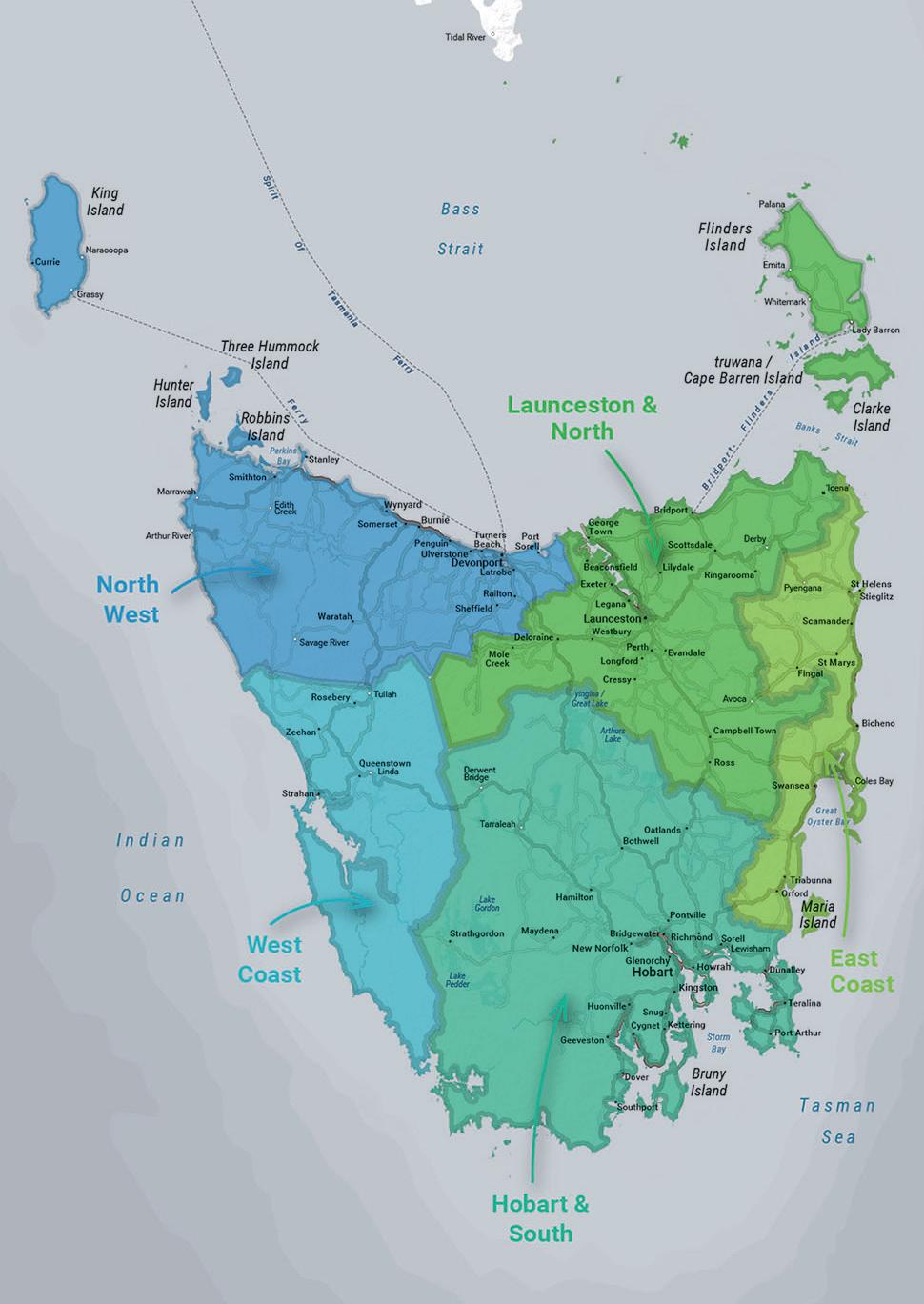
TOURIST REGIONS TASMANIA 2
Tasmania Contents 3 INTRODUCTION FOREWORD Matt Brogan 7 Editor’s top picks 8 ABOUT TASMANIA History 10 Indigenous groups 11 European history 15 ENVIRONMENT Geology 20 Aquaculture, viticulture and distilling 21 Animal spotting 22 Flora 25 PLANNING AND PREPARATION Before you go 28 On the road 31 Crossing Bass Strait 35 THINGS TO SEE AND DO Arts and culture 37 Wining and dining 38 4WD touring 39 Walking 40 Camping 42 Canoeing and kayaking 43 Cycling 44 Caving and climbing 45 Fishing 46 Sightseeing and photography 47 Night skies 48 REGION 1 - LAUNCESTON & NORTH Launceston and North 50 Tamar Region 53 Beaconsfield and surrounds 55 Deloraine 57 Mole Creek and surrounds 59 Westbury and surrounds 61 Longford 63 Perth, Evandale and Cressy 66 Campbell Town 69 Ross 71 Bridport and surrounds 73 Scottsdale and surrounds 75 Derby and surrounds 77 Flinders Island 79 REGION 2 - EAST COAST East Coast 84 Orford and Triabunna 87 Maria Island National Park 89 Little Swanport and Rocky Hills 90 Swansea 91 Freycinet National Park 93 Bicheno to Beaumaris 96 Winifred Curtis Scamander Reserve 98 St Helens and surrounds 99 REGION 3 - HOBART AND SOUTH Hobart and South 104 New Norfolk 108 Mount Field National Park 111 Maydena and Strathgordon 112 Hamilton and surrounds 114 Ouse 116 Wayatinah and Tarraleah 118 Port Arthur 120 Bruny Island 122 Huon Valley 125 REGION 4 - THE WEST COAST The West Coast 126 Cradle Mountain-Lake St Clair National Park 128 Franklin-Gordon Wild Rivers National Park 130 Queenstown 131 The Town of Pillinger 133 Strahan 134 Zeehan 138 Trial Harbour 140 Tullah 141 Corinna 143 REGION 5 - NORTH WEST North West 144 Waratah 146 The takayna/Tarkine 148 Arthur River 150 Smithton 151 Marrawah and Woolnorth 152 Stanley 154 Wynyard and surrounds 156 Burnie and surrounds 159 Devonport 160 Cradle Coast to the Meander Valley 162 King Island 164 Naracoopa 166 Grassy 167 Cape Wickham 168 TOP 5 WALKING TRACKS Introduction 170 TRACK 1 Bay of Fires Walk 174 TRACK 2 Overland Walk 176 TRACK 3 Maria Island Walk 178 TRACK 4 Three Capes Walk 180 TRACK 5 Walls of Jerusalem Walk 182 TOP 15 4WD TRACKS Introduction 184 TRACK 1 Borradaile Plains Track 186 TRACK 2 Ocean Beach Track 188 TRACK 3 Mount McCall Track & Mount Huxley Track 192 TRACK 4 Balfour Track 198 TRACK 5 Pyengana Jeep Track 200 TRACK 6 Climies Track 202 TRACK 7 Brushy Lagoon Track 204 TRACK 8 Southport Lagoon Track 206 TRACK 9 Bluestone Bay Track 210 TRACK 10 Meunna to Trowutta Arch Track (including Dip Falls) 212 TRACK 11 Jeffreys Track and White Timber Trail Track 216 TRACK 12 Sandy Cape Track 220 TRACK 13 Bridport to Bellingham Track (St Albans Bay 4WD Track) 224 TRACK 14 Montezuma Falls Track (North-East Dundas Tramway) 228 TRACK 15 Pieman Heads Track 230 ATLAS 234 INDEX 262
4
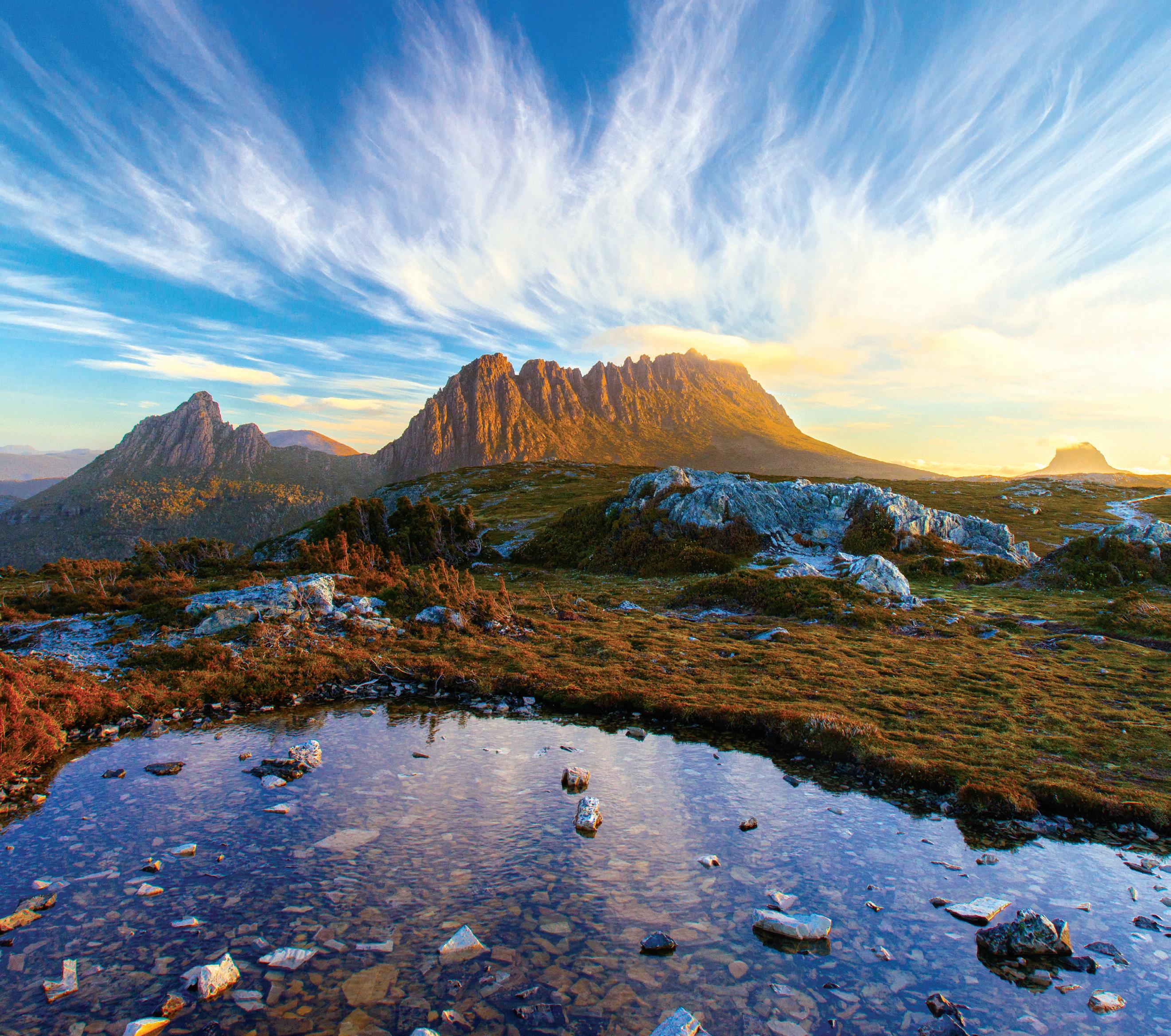
Tasmania Highlights


Grand views Hike or bike
The wind shelter and tourist information centre on the summit of Mount Wellington (1,271m) in Hobart, the capital city of Tasmania, Australia.
Natural wonderland
 Hiking the 65km Overland Track – rated as one of the world’s Top 10 walks – in Tasmania, Australia, with Barn Bluff in the background.
Located 75km north-west of Hobart, the Horseshoe Falls in the Mount Field National Park are one of 55 spectacular waterfalls in Tasmania, Australia.
Hiking the 65km Overland Track – rated as one of the world’s Top 10 walks – in Tasmania, Australia, with Barn Bluff in the background.
Located 75km north-west of Hobart, the Horseshoe Falls in the Mount Field National Park are one of 55 spectacular waterfalls in Tasmania, Australia.
History you can touch
The Richmond Bridge is a heritage-listed arch bridge located on the B31 in Richmond. Located 25km north of Hobart, this convictbuild bridge is the oldest stone span bridge in Australia having been opened in 1825. In 2005, the bridge was recognised as an outstanding historic place and added to the Australian National Heritage List.

Geological marvels
The most distinctive landmark in Stanley is Munatrik, commonly called The Nut. This geological formation is an old volcanic plug and was first sighted by Bass and Flinders on their circumnavigation of Van Dieman’s Land (now Tasmania) in 1798. Originally called Circular Head, The Nut has steep sides rising 143m to its flat top.

4WD paradise
There is simply no better way to explore Tasmania than by 4WD. With some of the most spectacular camping sites only accessible by 4WD, the real Tasmania is criss-crossed by dozens of four-wheel drive tracks, many the remnants of mining trails dating back to early 1800s. Discover forgotten towns and enjoy unrivalled views with our 15 detailed 4WD Maps (page 184) or by contacting one of Tasmania’s friendly four-wheel drive clubs.


Points of interest
The Franklin-Gordon Wild Rivers National Park is one of 19 in Tasmania. Located 117km west of Hobart, this untouched wilderness is named for the two rivers that lie within the park’s boundaries – the Franklin River and the Gordon River.

Rich Aboriginal heritage
Dating back over 40,000 years, the original inhabitants of Tasmania (which they called Lutruwita) left images and artefacts which detail their expression and beliefs. Today, Aboriginal Heritage Tasmania works with the community to promote the recognition, protection, and management of Tasmania’s unique Aboriginal culture heritage. It’s thought that more than a dozen different Aboriginal language groups existed in Tasmania prior to 1830, though most languages and traditions were lost with the death of the last native language speaker, Fanny Cochrane Smith, in 1905. A language revival project known as the Palawa Kani project is working to rediscover these lost languages via intensive archaeological research. Find out more at http://tacinc.com.au/programs/palawakani/

5

36
4WD touring
Unrivalled challenges and scenery makes Tasmania a bucket list location for many 4WDers, all it asks is that you be well prepared and, of course, to tread lightly.
Four-wheel drive touring is a terrific way to see parts of Tasmania that are otherwise difficult to access.
We mention a few of the better-known four-wheel drive tracks Tasmania has to offer in this guide, but there are many more, and local four-wheel drive clubs provide by far the most extensive list available.
In Chris Boden’s book, OffRoad Tasmania: 4WD Tracks in
Tasmania you will find over 55 roads are tracks to whet the appetite of even the most adventurous four-wheel driver, as well as the contact details of many of the state’s 4WD clubs.
Just remember, many areas of Tasmania are protected and special consideration must be taken when driving in such areas. Care must be taken to prevent the spread of Root Rot (see page 27) and to avoid
damaging protected plant life.
It is also recommended that your vehicle is in tip-top shape before setting off. Fuel and mechanical provisions can be few and far between. It may also be very difficult to find phone or radio reception in some parts of Tasmania, meaning a high level of preparedness and selfreliance is part of nearly every off-road journey.
For more information about
four-wheel driving in Tasmania, or to discover 15 of the best four-wheel drive tracks the state has to offer, visit page 184 of this guide.
Tasmania’s windswept west coast provides some of the more challenging, but equally beautiful, 4WD locations to explore – just remember to pack all that you may need (Pic Hema Maps).

TASMANIA THINGS TO SEE AND DO 39
Region 1 Launceston and North
Launceston and North (Map
pg 51)
An historic and scenic region with a storied past, Launceston and Tasmania’s north is home to unique villages, heritage estates, hedge-lined country lanes and some of the most remarkable natural areas the state has to offer. It’s also a terrific place in which to indulge in some of the best produce this side of Bass Strait.
Bucket list
Tamar Valley
Sample some of the best wines in one of Australia’s premier wine regions. Rolling hills of vineyards hug the banks of the River Tamar; nature’s bounty offering paddockto-plate cuisine. (Pic Jarrad Seng)

Best time to visit All year around, but do visit Launceston’s Harvest Market held every Saturday.
Situated at the southern tip of the kanamaluka / River Tamar is the vibrant city of Launceston. Nicknamed Launnie, the town is one of the oldest colonial settlements in Tasmania and home to some impressive stone structures including the water foundation at Prince’s Square.
establishment of Australia’s first underground sewage and official waste management system. The first surgical use of anesthetics in the southern hemisphere was administered here in 1847 by Dr William Russ Pugh. A bronze statue of Dr Pugh can be found in Prince’s Square, commemorating his lifelong service to medical science.
Things to see and do
Ben Lomond National Park
Drive up the steep mountain road of Jacob’s Ladder, a windy ascent until you reach the alpine plateau. Atop Ben Lomond is a breathtaking panoramic view; a pristine location for downhill skiing in the winter.
Trowunna Wildlife Sanctuary
Pat a furry little native (including a Tassie Devil) at this wonderful animal sanctuary, located near Mole Creek. Guided tours are available. (Pic Jarrad Seng)

Launceston was the first town in Australia to use hydroelectricity, thanks to its prime location along the longest river in Tasmania, the South Esk River. This river forms part of the territorial boundary between The North Midlands Nations, in the west, and The Ben Lomond, towards the southeast. The former power plant using the pure force of the South Esk River, the Duck Reach Power Station, ceased operation in 1995. Hydroelectric power was later harnessed at the Trevallyn Hydroelectric Power Station located along the River Tamar.
Another engineering feat of this booming metropolis was the
Visit the Queen Victoria Museum and Art Gallery www.qvmag.tas.gov.au to marvel at the exquisite art exhibition and learn more about Tasmania’s rich history. On the grounds resides the old railway station and rail yards, which can be explored at the Launceston Tramway Museum.
Australian’s famous brewhouse James Boags Brewery www.jamesboag.com. au is located at the heritage-listed Tamar Hotel, a stunning Victorian era structure.
Harvest Market Launceston, convivial, weekly farmers’ market offering produce and food items, plus takeaway eats and live music (Pic Tourism Australia).

50

K ! ! ! ! ! ! ! ! ! ! ! ! ! ! ! ! ! ! ! ! ! ! ! ! ! ! ! ! ! ! ! ! ! ! ! ! " A A 1 A A 1 A A 1 B B A4 B B A7 B B A3 B B A3 B B A5 B B A10 B B A8 Ferry S pi r it Of T a s m a n i a F e r r y Bridp ortFlinder s Isla n d T a s m a n Hig hw a y Tasman Hwy Bass Hwy East Hwy Tasman Highway Hwy Lyell Hwy Hwy Midland Hwy H gi h dnal Lakes Road Bass Hwy Midland Ta s man Tamar Marshall Bay SistersPass. Schouten Pass. WaterhousePass. Banks Strait R. O u se M a c quari e R. R. S outh Esk River N ive R R . Riv er Derwent Ri n g aroom a Me r s y La ke S a in t La ke S a in t Cla ir Cla Lake Sorell Lake King William Lake William La ke Ec ho La ke Ec ho Moulting Lagoon yingina / Great Lake Ar thurs Lake Bas s S t r a i t Tasma n S e a Mount Ossa 1617m F lind er s Is l a n d t ru w a n a / Ca p e Barre n Is l a n d C l ar k e I s Narawntapu NP Str zelec k i NP Frey c in et Nat io na l Pa rk 'Icena WildDogTier WentworthHills Darl i ngR a . TravellerRa. Nicholas Ra. K i ng Wil l i am R a Cradle Mountain-Lake St Clair NP Fra nk li n- G ordon W ild Rivers N P Mt William DouglasApsley NP Ben Lomond NP Wa lls of Je rus al em N P Freycinet National Park Darling Ra. CA Princess River CA Ap s la wn Reg io na l Res erv e Moulting Lagoon Game Reserve Swan River Regional Reserve Bl ue Tier Reg io na l Res erv e Patri arch s CA Castle Cary RR Ba y of F ires Con s erva tion Ar ea Great Western Tiers CA Mou nt Pears on Sta te R eser ve Cameron Regional Reserve Wingaroo NR Foochow CA Sellars Lagoon Game Res. Mount Maurice Regional Reserve Logan Lagoon CA Doctors Peak RR St Pau ls RR North Sc otts dale RR Mount Victoria RR To oms L ake Con s erva tion Area Great Lake CA Reedy Ma rsh CA Eastern Tiers CA Cygn et R iv er Reg io na l Res erv e Avenue River Regional Reserve Buxton River CA Butlers Ridge NR Mount Tanner NRA Ta ma r CA Central Plateau CA Pyengana Lady Barron Avoca Coles Bay Tarraleah Whitemark Derwent Bridge Derby Emita Palana Swansea Bicheno Stieglitz Ross Campbell Town Fingal Oatlands Bothwell St Mar ys Mole Creek Lilydale Scamander Ringarooma Cressy Exeter Railton Gog Ra Fingal Tier GreatPineTier G r e a t W e s t e r n T ie r s Anderson Bay B a y o f F i r e s R i n g a roo m a Ba y Great Oyster Bay Latrobe St Helens Por t Sorell Sheffield George Town Low Head Westbury Bridpor t Scottsdale Beaconsfield Deloraine Per th Evandale Legana Longford Penguin Fra n k li n S ou n d Burnie Ulverstone Launceston Devonpor t Launceston & Nor th See Page 81 See Page 83 See Page 77 See Page 53 See Page 55 See Page 57 See Page 65 See Page 69 See Page 71 V 0 20 40 km © Hema Maps 2022 51
Walking Track 1 Bay of Fires Walk
One of the world’s most beautiful beaches
The Bay of Fires Walk is arguably one of Tasmania’s most picturesque with views that change by the hour as the sun sweeps over the coast.
Tasmania’s Bay of Fires region is a popular destination for day-trippers and enthusiastic walkers who are catered for by several guided tour operators offering a range of experiences – from easy coastal walks to guided multi-day hikes that vary in distances covered and the degree of luxury offered.
The latter, more expensive option can involve overnight “glamping,” or accommodation in beach house or lighthouse-keeper cottages while the former can include less-exotic individual hikes utilising the basic campsites that are provided along the way. The duration of the guided walks varies, but four days is at the top end of the scale.
The Bay of Fires region – named by English Captain Tobias Furneaux in the 1770s after the sighting of Aboriginal fires along the coast that lit up the sky at night –stretches 50km along Tasmania’s north-east coast via larapuna/Eddystone Point in the Mount William National Park to Binalong Bay, not far from the picturesque fishing town of St Helens. Shell and bone-dumping grounds from cooking fires, known as middens, are still evident in some places.
The attractions of walking the Bay of Fires are consistent with the location:

sandy white beaches, brilliant blue sea, orange lichen-covered granite rocks, lagoons and rocky bluffs, all against a thick low-lying coastal vegetation that is so representative of the region.
The vistas from the Binalong Bay viewing platform or the headland at The Gardens – named after the tracts of wildflowers that grow in the area – are breathtaking.
Along with aquatic treats such as snorkelling and whale and dolphin spotting, there’s also abundant bird life, as well as signs of the aboriginal activity that gave this area of the Tasmanian coast its name.
A typical four-day catered walk at the Bay of Fires will begin at Boulder Point near the low-lying Mount William in the north, then work its way south to finish near the fishing village of Anson’s Bay in the south, traversing rocky gullies and exploring small, secluded beaches along the way – including the signature Binalong Bay.
The distances covered can vary enormously and walking is generally not difficult because of the flatness of the terrain. That said, you may encounter areas of soft sand. But believe us, the rewards vastly outweigh the physical effort outlaid.
Bay of Fires Walk Elevation
Bay of Fires Walk details
Grade: 3
Days to complete: 4
Distance: Up to 50km
Requirements: Bookings recommended/optional. https://parks.tas.gov.au/
Note: Map pg 175, is showing a portion of the most ‘scenic’ part of the walk.
174
0 200 400 600 800 1000 0 2 4 6 8 10 12 E e v a o n m Distance [km] ~ P o i c e m a n s P o i n t C a m p i n g A r e a G a r d e n s L a g o o n B e a c h B r e a k Y o k e B e a c h P e b b l y B e a c h 1 1 1 9 5 5 3 5 1 9 10 1 0 12 3 9 8 5 3 5 12 0
Distances are based on the selected map highlight and can therefore differentiate from the official Tasmanian Parks and Wildlife Service walking distances.
Looking across the Bay of Fires (Pic Tourism Tasmania and Andrew McIntosh, Ocean Photography).

" " " " " " " ! ! ! ! ! ! ! ! ! ! ! ! ! ! ! ! ! ! ! ! ! ! ! ! ! ! ! ! ! ! ! ! ! ! ! ! ! ! ! ! ! ! ! ! ! ! ! ! ! ! ! ! ! ! ! ! ! ! ! ! ! ! ! ! ! ! ! ! ! ! ! ! ! ! ! ! ! ! ! ! ! ! ! ! ! ! ! ! ! ! ! ! ! ! ! ! ! ! ! ! ! ! ! ! ! ! ! ! ! ! ! ! ! ! ! ! ! ! ! ! ! ! ! ! ! ! ! ! ! ! ! ! ! ! ! ! ! ! ! ! ! ! ! ! ! ! ! ! ! ! ! ! ! ! ! ! ! ! ! ! ! ! ! ! ! ! ! ! ! ! ! ! ! ! ! ! ! ! ! ! ! ! ! ! ! ! ! K ! ! L L L 2 6 r 200 100 100 100 100 100 2 0 0 1 0 0 Gripe Creek P ig s ty Ck Las t R v e r Yacca Creek S e al Lag o o n Creek Sam p s ons Cr e e k Bi g C r e e k Brea k Yoke Creek T hmo sa Creek Bullock Be ll Cree k Janeys Creek Broadwa t e r Creek Baileys Cre e k Steels Cre e k Scotsmans C r e e k Jacks L o o k o ut Creek Teagardens Cree k Ansons River An son s River Break Yoke Beach Gar dens L ag oon Bea c h Pebbl y Beac h Poli cem an s Poi nt The Shades 282m 170m 125m B B C848 B B C843 B B C843 T HE G A R DEN S A N SO N S B A Y M o u n t Willi a m N at ion a l P ar k Mo u n t Willi a m N P Ba y o f F i r e s Bay of Fires Conservation Area Ansons Bay Conservation Area Doctors Peak Regional Reserve Ansons River Conservation Area A n so n s Ba y Gardens Lagoon Private e t a v r P Pvt. Pri v ate Private Private Pvt. No Public Access No Public Access No Public Access No No No Access Access Ac cess Public Public Pu b l ic No Public Access No Public Access MVO MVO MVO yaB o f F i r se C o a s t la W a l k Bay o f Fires Coastal Wa l k Policemans Groves Road Point Road Ansons Bay Road A n s o n s Bay Gdra ne s R d Road y Bay of Fi res The Bay of Fires star ts at Binalong Bay and ends at Ansons Bay. With its sweeps of snow-white sand separated by numerous granite headlands stained red by algae some say it’s the most beautiful stretch of beach in the state. Policemans Point Camping Area Th e G arden s ! ! 1 ! ! 1 V 0 1 2 km © Hema Maps 2022 ! Hobart To St Helens / Binalong Bay To St Helens To Ansons Bay 175
Track 12 Sandy Cape Track
A worthwhile and picturesque track for those with a sense of adventure
As one of several challenging tracks that run along Tasmania’s rugged West Coast, the Sandy Cape Track can at times be extremely difficult, but always worthwhile. Like any good boy scout, we recommend you come prepared.
Driving the track
Located within the Arthur-Pieman
Conservation Area, the Sandy Cape Track provides outstanding coastal scenery and beautiful camping spots. As the area is quite remote, it’s recommended you fill up at Corinna, if entering from the south, or Marrawah if entering from the north.

The main campsites are located at Greenes Creek, Pedder River, and Sandy Cape. Camping fees are included in the purchase of a Recreational Drivers Permit for the sea south of Temma and camping is offered on a first-come, first-served basis.

Camping fees apply for sites north of Temma and can be purchased at the Arthur River Parks and Wildlife Service Office Fishing is allowed only where signposted.
From Temma to Greenes Creek, approximately 12km, the track is rated to an
easy 4WD track. However, it can become slippery and more difficult after heavy rain with deep-water sections. The later beach section of the drive, from Greenes Creek to Sandy Cape, is rated as Difficult. The track comprises a mix of sandy and rocky
CLOCKWISE FROM BELOW: Arthur-Pieman Conservation Area, surrounded by dense rainforest and named after the wild river that runs from the mountains to the sea, Arthur River is a great base for exploring the takayna / Tarkine wilderness, Tasmania’s largest tract of temperate rainforest (Pic Jess Bonde); The cruise on this North West Tasmania river takes you 14kms along Arthur River, first to the river mouth then upstream past the Arthur and Frankland river junction before continuing on to Warra Landing for lunch; Arthur River Cruises is an unforgettable wilderness experience (Pics Tourism Australia).

Sandy Cape Track details
Grade: D
Time: 2-3 hours
Distance: 26.5km
Best Time of Year: Any Permits and Fees: Arthur-Pieman
Recreational Drivers Pass
Contact Details: Arthur River Field Centre, 1490 Arthur River Rd, Arthur River TAS 7330. Ph 03 6457 1225 or visit parks.tas.gov.au/explore-ourparks/arthur-pieman-conservation-area
Highlights: Aboriginal sites, coastal views, Bartel’s monument
Getting There: The Sandy Cape Track is accessed by first following the C214 (Rebecca Rd) west from Kanunnah Bridge or south from Arthur River. Head south at the intersection of Temma Rd near Couta Rocks and follow the road until it intersects with the Sandy Cape Track. Fuel is available at Zeehan or Smithton.
Facilities
Camping available
220
MUST SEE
Big
Balfour Track Warning
Balfour Track Warning
Numerous deep water hazards, snorkle/winch/recovery gear essential, multiple buddy vehicles required. Majority of track can be submerged in wet season. Attempt only in dry season.
Ar thur Pieman Conservation Area permit required for access.
Numerous deep water hazards, snorkle/winch/recovery gear essential, multiple buddy vehicles required. Majority of track can be submerged in wet season. Attempt only in dry season. Ar thur Pieman Conservation Area permit required for access.
Balfour Track Warning
Ar thur-Pieman Conservation Area
Contact Ar thur River Parks and Wildlife Service on (03) 6457 1225 regarding permits and 4WDing in the conservation area.
Access to Sandy Cape should be done in convoy of at least 2 vehicles, at low tide, low tyre pressures and heeding to local Ar thur River ranger beach conditions warnings
Sandy Cape Beach Warning
This par t of the Sandy Cape Track can be treacherous during par ts of the year
This par t of the Sandy Cape Track can be treacherous during par ts of the year
This beach traverse contains four major ford crossings which should only be attempted at low tide and with snorkle/winch/recovery gear and multiple buddy vehicles present. Obtain the latest Ar thur River Ranger warnings for the beach and ford crossings before proceeding.
This beach traverse contains four major ford crossings which should only be attempted at low tide and with snorkle/winch/recovery gear and multiple buddy vehicles present. Obtain the latest Ar thur River Ranger warnings for the beach and ford crossings before proceeding.
" " " " " " " " " " " " " " TemmaGreenes C r e e k T r ack ) s ! ! ! ! ! ! ! ! ! ! ! ! ! ! ! ! ! ! ! ! ! ! ! ! ! ! ! ! ! ! ! ! ! ! ! ! ! ! ! ! ! ! ! ! ! ! ! ! ! ! ! ! ! ! ! ! ! ! ! ! ! ! ! ! ! ! ! ! ! ! ! ! ! ! ! ! ! ! ! ! ! ! ! ! ! ! ! ! ! ! ! ! ! ! ! ! ! ! ! ! ! ! ! ! ! ! ! ! ! ! ! ! ! ! ! ! ! ! ! ! ! ! ! ! ! ! ! ! ! ! ! ! ! ! ! ! ! ! ! ! ! ! ! ! ! ! ! ! ! ! ! ! ! ! ! ! ! ! ! ! ! ! ! ! ! ! ! K ! !! ! ! ! ! ! ! ! ! L L L L 6 9 12 r r r r r r Daisy River Brooks C r e e k No Mans Creek Rive r N o r t h Pedder R i v e r Creek W ild Wave River Mc L e od River Creek Buc k b y Cr eek Native H ut C r e e k B i g Ee l C r eek R e becca Dawson River Murray Thornto n R i v e r Pedder Sandy Cape Lighthouse Ordnance Point Sa ndy C ap e ford ford ford ford ford ford B B C249 245m 138m 77m 49m 110m Temma Conservation Covenant (private) A r t hur- P ie ma n Con se r v at ion A r e a A r t hur- P ie ma n Con se r v at ion A r e a Sch ram ms C ove Ingram Bay Dawson Bay K e nn e th Ba y Hazard Bay I n d i a n O c e a n ST705 Permi t Req u i r e d Permit Req u deri R e q u ired Permi t R e qui red Permit Required Permit Permit Req. Restricted R e s tricted Pvt . No Public Access No Public Access N o Publi c A c c ess No Public Acc e ss P ermanently Closed Permanently Closed Perm Closed D r y Weather ylno Dry Weather only D r y D r y Weath er o n yl Dry Weather only MVO MV O MVO MVO M V O MVO MVO MVO MVO MVO M Sandy C a pe T rack Pedder River Track Track Balfour Balfour Track Bens Top Track TemmaG r e e sen C r e ek Track Temma Rd Sandy Cape Bridge X X X y Ar thur-Pieman Conservation Area Contact Ar thur River Parks and Wildlife Service on (03) 6457 1225 regarding permits and 4WDing in the conservation area. \
\
Gr eene s C reek ~ Nor th P edder Rive r ~ Sandy Cape ~
Eel
~ Temma ! ! 12 ! ! 12
Bush Camp
V 0 2 4 km © Hema Maps 2022 " " " " " " " " " " " " " " TemmaGreenes
e k T r ack ) s ! ! ! ! ! ! ! ! ! ! ! ! ! ! ! ! ! ! ! ! ! ! ! ! ! ! ! ! ! ! ! ! ! ! ! ! ! ! ! ! ! ! ! ! ! ! ! ! ! ! ! ! ! ! ! ! ! ! ! ! ! ! ! ! ! ! ! ! ! ! ! ! ! ! ! ! ! ! ! ! ! ! ! ! ! ! ! ! ! ! ! ! ! ! ! ! ! ! ! ! ! ! ! ! ! ! ! ! ! ! ! ! ! ! ! ! ! ! ! ! ! ! ! ! ! ! ! ! ! ! ! ! ! ! ! ! ! ! ! ! ! ! ! ! ! ! ! ! ! ! ! ! ! ! ! ! ! ! ! ! ! ! ! ! ! ! K ! !! ! ! ! ! ! ! ! ! L L L L 6 9 12 r r r r r r Daisy River Brooks C r e e k No Mans Creek Rive r N o r t h Pedder R i v e r Creek W ild Wave River Mc L e od River Creek Buc k b y Cr eek Native H ut C r e e k B i g Ee l C r eek R e becca Dawson River Murray Thornto n R i v e r Pedder Sandy Cape Lighthouse Ordnance Point Sa ndy C ap e ford ford ford ford ford ford B B C249 245m 138m 77m 49m 110m Temma Conservation Covenant (private) A r t hur- P ie ma n Con se r v at ion A r e a A r t hur- P ie ma n Con se r v at ion A r e a Sch ram ms C ove Ingram Bay Dawson Bay K e nn e th Ba y Hazard Bay I n d i a n O c e a n ST705 Permi t Req u i r e d Permit Req u deri R e q u ired Permi t R e qui red Permit Required Permit Permit Req. Restricted R e s tricted Pvt . No Public Access No Public Access N o Publi c A c c ess No Public Acc e ss P ermanently Closed Permanently Closed Perm. Closed D r y Weather ylno Dry Weather only D r y Weather o n yl D r y Weath er o n yl Dry Weather only MVO MV O MVO MVO M V O MVO MVO MVO MVO MVO MVO Sandy C a pe T rack Pedder River Track Track Balfour Balfour Track Bens Top Track TemmaG r e e sen C r e ek Track Temma Rd Sandy Cape Bridge X X X y
C r e
\
Sandy Cape Beach Warning
\
Gr eene s C reek ~ Nor th P edder Rive r ~ Sandy Cape ~ Big Eel Bush Camp ~ Temma ! ! 12 ! ! 12 Balfour Track Warning
V 0 2 4 km © Hema Maps 2022 ! Hobar t To Balfour 221
Access to Sandy Cape should be done in convoy of at least 2 vehicles, at low tide, low tyre pressures and heeding to local Ar thur River ranger beach conditions warnings
# # 3 # # 3 # # 3 1 1 2 2 3 3 4 4 5 5 6 6 7 7 K K J J H H G G F F E E D D C C B B A A ! ! ! ! ! ! ! ! ! ! ! ! ! ! ! ! ! ! ! ! ! ! ! ! ! ! ! ! ! ! ! ! ! ! ! ! ! ! ! ! ! ! ! ! ! ! ! ! ! ! ! ! ! ! ! ! ! ! ! ! ! ! ! ! ! ! ! ! ! ! ! ! ! ! ! ! ! ! ! ! ! ! ! ! ! ! ! ! ! ! ! ! ! ! ! ! ! ! ! ! ! ! ! ! ! ! ! ! ! ! ! ! ! ! ! ! ! ! ! ! ! ! ! ! ! ! ! ! ! ! ! ! ! ! ! ! ! ! ! ! ! ! ! ! ! ! ! ! ! ! ! ! ! ! ! ! ! ! ! ! ! ! ! ! ! ! ! ! ! ! ! ! ! ! ! ! ! ! ! ! ! ! ! ! ! ! ! ! ! ! ! ! ! ! ! ! ! ! ! ! ! ! ! ! ! ! ! ! ! ! ! ! ! ! ! ! ! ! ! ! ! ! ! ! ! ! ! ! ! ! ! ! ! ! ! ! ! ! ! ! ! ! ! ! ! ! ! ! ! ! ! ! ! ! ! ! ! ! ! ! ! ! ! ! ! ! ! ! ! ! ! ! ! ! ! ! ! ! ! ! ! ! ! ! ! ! ! ! ! ! ! ! ! ! ! ! ! ! ! ! ! ! ! ! ! ! ! ! ! ! ! ! ! ! ! ! ! ! ! ! ! ! ! ! ! ! ! ! ! ! ! ! ! ! ! ! ! ! ! ! ! ! ! ! ! ! ! ! ! ! ! ! ! ! ! ! ! ! ! ! ! ! ! ! ! ! ! ! ! ! ! ! ! ! ! ! ! ! ! ! ! ! ! ! ! ! ! ! ! ! ! ! ! ! ! ! ! ! ! ! ! ! ! ! ! ! ! ! ! ! ! ! ! ! ! ! ! ! ! ! ! ! ! ! ! ! ! ! ! ! ! ! ! ! ! ! ! ! ! ! ! ! ! ! ! ! ! ! ! ! ! ! ! ! ! ! ! ! ! ! ! ! ! ! ! ! ! ! ! ! ! ! ! ! ! ! ! ! ! ! ! ! ! ! ! ! ! ! ! ! ! ! ! ! ! ! ! ! ! ! ! ! ! ! ! ! ! ! ! ! ! ! ! ! ! ! ! ! ! ! ! ! ! ! ! ! ! ! ! ! ! ! ! ! ! ! ! ! ! ! ! ! ! ! ! ! ! ! ! ! ! ! ! ! ! ! ! ! ! ! ! ! ! ! ! ! ! ! ! ! ! ! ! ! ! ! ! ! ! ! ! ! ! ! ! ! ! !! ! ! ! ! ! ! ! ! ! ! ! ! ! ! ! ! ! ! ! ! ! ! ! ! ! ! ! ! ! ! ! ! ! ! ! ! ! ! ! ! ! ! ! ! ! ! ! ! ! ! ! ! ! ! ! ! ! ! ! ! ! ! ! ! ! ! ! ! ! ! ! ! ! ! ! ! ! ! ! ! ! ! ! ! ! ! ! ! ! ! ! ! ! ! ! ! ! ! ! ! ! ! ! ! ! ! ! ! ! ! ! ! ! ! ! ! ! ! ! ! ! ! ! ! ! ! ! ! ! ! ! ! ! ! ! ! ! ! ! ! ! ! ! ! ! ! ! ! ! ! ! ! ! ! ! ! ! ! ! ! ! ! ! ! ! ! ! ! ! ! ! ! ! ! ! ! ! ! ! ! ! ! ! ! ! ! ! ! ! ! ! ! ! ! ! ! ! ! ! ! ! ! ! ! ! ! ! ! ! ! ! ! ! ! ! ! ! ! ! ! ! ! ! ! ! ! ! ! ! ! ! ! ! ! ! ! ! ! ! ! ! ! ! ! ! ! ! ! ! ! ! ! ! ! ! ! ! ! ! ! ! ! ! ! ! ! ! ! ! ! ! ! ! ! ! ! ! ! ! ! ! ! ! ! ! ! ! ! ! ! ! ! ! ! ! ! ! ! ! ! ! ! ! ! ! ! ! ! ! ! ! ! ! ! ! ! ! ! ! ! ! ! ! ! ! ! ! ! ! ! ! ! ! ! ! ! ! ! ! ! ! ! ! ! ! ! ! ! ! ! ! ! ! ! ! ! ! ! ! ! ! ! ! ! ! ! ! ! ! ! ! ! ! ! ! ! ! ! ! ! ! ! ! ! ! ! ! ! ! ! ! ! ! ! ! ! ! ! ! ! ! ! ! ! ! ! ! ! ! ! ! ! ! ! ! ! ! ! ! ! ! ! ! ! ! ! ! ! ! ! ! ! ! ! ! ! ! ! ! ! ! ! ! ! ! ! ! ! ! ! ! ! ! ! ! ! ! ! ! ! ! ! ! ! ! ! ! ! ! ! ! ! ! ! ! ! ! ! ! ! ! ! ! ! ! ! ! ! ! ! ! ! ! ! ! ! ! ! ! ! ! ! ! ! ! ! ! ! ! ! ! ! ! ! ! ! ! ! ! ! ! ! ! ! ! ! ! ! ! ! ! ! ! ! ! ! ! ! ! ! ! ! ! ! ! ! ! ! ! ! ! ! ! ! ! ! ! ! ! ! ! ! ! ! ! ! ! ! ! ! ! ! ! ! ! ! ! ! ! ! ! ! ! ! ! ! ! ! ! ! ! ! ! ! ! ! ! ! ! ! ! ! ! ! ! ! ! ! ! ! ! ! ! ! ! ! ! ! ! ! ! ! ! ! ! ! ! ! ! ! ! ! ! ! ! ! ! ! ! ! ! ! ! ! ! ! ! ! ! ! ! ! ! ! ! ! ! ! ! ! ! ! !! ! ! ! ! ! ! ! ! ! ! ! ! ! ! ! ! ! ! ! ! ! ! ! ! ! ! ! ! ! ! ! ! ! ! ! ! ! ! ! ! ! ! ! ! ! ! ! ! ! ! ! ! ! ! ! ! ! ! ! ! ! ! ! ! ! ! ! ! ! ! ! ! ! ! ! ! ! ! ! ! ! ! ! ! ! ! ! ! ! ! ! ! ! ! ! ! ! ! ! ! ! ! ! ! ! ! ! ! ! ! ! ! ! ! ! ! ! ! ! ! ! ! ! ! ! ! ! ! ! ! ! ! ! ! ! ! ! ! ! ! ! ! ! ! ! ! ! ! ! ! ! ! ! ! ! ! ! ! ! ! ! ! ! ! ! ! ! ! ! ! ! ! ! ! ! ! ! ! ! ! ! ! ! ! ! ! ! ! ! ! ! ! ! ! ! ! ! ! ! !! ! ! ! ! ! ! ! ! ! ! ! ! !! ! ! ! !! !! ! !! ! ! ! ! ! ! ! ! ! ! ! ! ! ! ! ! ! ! ! ! ! ! ! ! ! ! !! ! ! !!! ! ! ! ! ! ! ! ! ! ! ! ! ! ! ! ! ! ! ! ! ! ! ! ! ! ! ! ! !!!!! ! ! ! ! ! ! ! ! ! ! ! ! ! ! ! ! ! ! ! !! ! ! ! ! ! ! ! ! ! ! ! ! ! ! ! ! ! ! ! ! ! ! ! ! ! ! ! ! ! ! ! ! ! ! ! ! ! ! ! ! ! ! ! ! ! ! ! ! ! ! ! ! ! ! ! ! ! ! ! ! ! ! ! ! ! ! ! ! ! ! ! ! ! ! ! ! ! ! ! ! ! ! ! ! ! ! ! ! ! ! ! ! ! ! ! ! ! ! ! ! ! ! ! ! ! ! ! ! ! ! ! ! ! ! ! ! ! ! ! ! ! ! ! ! ! ! ! ! ! ! ! ! ! ! ! ! ! ! ! ! ! ! ! ! ! ! ! ! ! ! ! ! ! ! ! ! ! ! ! ! ! ! ! ! ! ! ! ! ! ! ! ! ! ! ! ! ! ! ! ! ! ! ! ! ! ! ! ! ! ! ! ! ! ! ! ! ! ! ! ! ! ! ! ! ! ! ! ! ! ! ! ! ! ! ! ! ! ! ! ! ! ! ! ! ! ! ! ! ! ! ! ! ! ! ! ! ! ! ! ! ! ! ! ! ! ! ! ! ! ! ! ! ! ! ! ! ! ! ! ! ! ! ! ! ! ! ! ! ! ! ! ! ! ! ! ! ! ! ! ! ! ! ! ! ! ! ! ! ! ! ! ! 150 100 200 50 150 100 100 50 100 50 200 150 50 100 100 250 150 100 50 50 R O S E B A Y MOU N T S T U A R T N U NEW T O W N G L E B E H OBA R T T N O R T H H OBA R T B AT TE R Y PO I N T R OS N Y SA N D Y B A Y MOU N T NE LSO N D YN N YRN E T OL M A N S H IL L SOU T H H OBA R T QU EEN S D O M A I N WE S T H OBA R T MO N T A G U B A Y ! ! E Pvt . Pvt . Pvt. Pvt . Manag e m tne heVicle Only F e r r y F e r r y Mcaulay Road Clarence F o re s h ore Trail Pedder St Lord Street Yolla St oDbosbnos Rooaad d Albuera St FitzroyCr Clark Road King Street ZoomayyAv LoowweerrJJoorrddaan n Hiilll l R Rd Corby A v Riawena Road Balaka St Waterrwworkks s R Rooaad d WelleslWentworthStreet WellesleySt eySt Loinah Rd Davies Avenue Fren ch Street K aoota Roa d Beeaach R d BeeddomeeSSttrreet t SalvatorRoad oM o r t i mer r A v KellatieRd Domain Upper Road Coolll e ge e Rd d Yoorrk k Sttrreeeet t ConaraRoad Collins Street ElmaRd L e t i ti a S t Mona St ScottSt QuornSt PittSt AllisonSt CrossSt SwanSt Queen Street Mary St NiirreeeeLLaane Kelly S t FelthamSt McdevittA v WellingtonSt M a r ana Av Frase r St Loonng g P Po o i in n t R Rd d Bayley Street Carr Street P i l l i ing e er Sttrreeeet t N i nd a Street Je nn ing s St Bell St LambertAvenue FaradayStreet Bishop St Earl Street Lochner S t Mckellar St Baay y R Rooa d Pirie Street DynnyrneRoad Weld Street Upper Domain Rd Poets Road Adelaide Street Carriage Drive Romilly St CleaarryyssGGaattees Rooaad d Alexander Street Livveerrppooool l Cr Mawhera Av B r roowwnne e St trreeeet t Maning Avenue Anglesea Street Qeu e ns Walk Federal Street T o p h a m Street M a r i ieev v i l l le Essp p Deerrwweentwwaatter Avennuue e Reed d Chhaappeel l A Avveennuue e O l ld dhhaam m A Avvenuue e Neewwddeeggate e Sttrreeeet t Cornwa l l St Bellevue Parade Aberdeen St View Street Swannssttoon n S St t r reeeet t Esplanade Grosvenor S treet Forest Road Patrick Street Lower r D o m a ni n R o oaad d K e l la t i e R d Gowrie St Loina St FranklinSt Cressy St Rupert Av StrahanSt GeorgeSt Seymour St StGlen PeelSt BalfourCt QuambyAv Church St MinalloSt UnionSt DavidAv DenisonSt OberonCt L a n s downe Crescent PettySt ManresaCt Sandown Av KnockloftyTce TasmaSt HamiltonSt WhelanC r Akuna St Seabird Lane Essex St H a v en Ct Vic t oria Esp Leura Street NimalaSt RosnyLookou t R d Elphinstone Rd Arthur Street Hill Street Montagu Bay Road Park St EynsoR s lp a nade Clare Street D'ArcyStreet iL ocsp m b e Avenue HillStreet Nelson Road Waimea Av Kiinng g Sttrreeeet t Bastick Stre e t Waarrwwiicck k St t Prroocctorrs s Rooad Elizabeth St DigneySt MolleSt Churrcchilll Av v Churchill Avenue nosleN Road nosleNRoad Letitia Street Paarrk k S St treeet t Lynton Av MacquarieSt Re gent Str eet C a ampbbeelll l S St t Davveey y S Sttrreeet t Huuon R Rd Augusta Rd Murray St MurraySt BuurrnettttSSt t E lizzaabbeetth St t Neew w T o w n R o oaad d A r g gyyl l e Street tr t Saannddy y Bay y Roaad d HarringtonSt LiverpoolSt Doommaaiin Hiig ghwaay y Tasman n Hiigghhwwaay y Soouutthheerrn n Ouut t l leet t T a s m a n H ig g hwaay B r o ookeer r H i ig g h hw a y Taassmmaan n B Brriiddgge e / T Taassmmaan n H Hiigghhwway Eaasst t D Deerrwween n t H i g h hway B r roookeer r Avennuue e Davey Street Gordons Hill NR Area A A 1 B B B32 B B C643 B B B36 B B64 B B B68 B B A6 B B A3 M ina n g H o b art Rivulet Proc t o r s Ck Rifl e R a n g e Creek Sandy B ay Rvt L a m be r t R v t L i p s c om be R v t Rvt R i v e r D e r w e n t Mcaulay Reserve Parliament Street Reserve Uni. Rose Garden Long Beach Reserve Nor th Hobar t Oval Sandown Park Ar thur Circus Queensborough Oval John Doggett Park Royal Tasmanian Botanical Gardens Red Chapel Reserve Charles Hand Memorial Park Lamber t Park Fitzroy Gardens University of Tasmania Railway Station M ain Li n e 2 E 2 2 E 2 2 8 2 2 E E : L Cornelian Bay p M Corinda's Cottages Ph: 03 6240 4836 a Rydges Hobar t Ph: 03 6231 1588 a p MACq 01 Hotel Ph: 03 6210 7600 a 8 Soundy Park p Best Western Hobar t Ph: 03 6232 6255 a Somerset on the Pier Hobar t Ph: 03 6220 6600 a : L : 8 : 8 Errol Flynn Reserve p T Caldew Park p : L The Henry Jones Ar t Hotel Ph: 03 6210 7700 a 8 Rosny Hill Lookout ] Hobar t Tower Motel Ph: 03 6228 0166 a Ibis Styles Hobar t Ph: 03 6289 8500 a The Old Woolstore Apar tment Hotel Ph: 03 6235 5355 a Hadley s Orient Hotel Ph: 03 6237 2999 a Quest Waterfront Ph: 03 6224 8630 a Mantra on Collins Hobar t Ph: 03 6226 1111 a Salamanca Wharf Hotel Ph: 03 6224 7007 a Travelodge Hotel Hobar t Ph: 03 6220 7100 a Lenna of Hobar t Ph: 03 6232 3900 a Hotel Grand Chancellor Hobar t Ph: 03 6235 4535 a Tasmanian Travel and Information Centre Ph: 03 6238 4222 i Salamanca Market Ph: 03 6238 2410 The International Wall of Friendship Allpor t Library and Museum of Fine Ar ts Theatre Royal Parliament House Federation Concert Hall Hobar t Cenotaph Government House Tasmania Salamanca Ar ts Centre Water by Nature Tasmania - Franklin River Rafting Markree House Museum and Garden Constitution Dock Tasmanian Museum and Ar t Gallery Royal Tasmanian Botanical Gardens Kelly's Steps Australian Army Museum of Tasmania Gasworks Cellar Door Maritime Museum of Tasmania Narryna Heritage Museum Wrest Point Casino Mawson's Huts Replica Hobar t Convict Penitentiary Princes Park Salamanca Market Ho p Pro ducts Austral ia Austral Sandy Bay 0 0.3 0.6 km V Tasmania Atlas 2 # # 3 MAP 2 234
# # 24 # # 24 # # 24 0 1 2 km V © Hema Maps # # 24 1 1 2 2 3 3 4 4 5 5 6 6 7 7 K K J J H H G G F F E E D D C C B B A A ! ! ! ! ! ! ! ! ! ! ! ! ! ! ! ! ! ! ! ! ! ! ! ! ! ! ! ! ! ! ! ! ! ! ! ! ! ! ! ! ! ! ! ! ! ! ! ! ! ! ! ! ! ! ! ! !! ! ! ! ! ! ! ! ! ! ! ! ! ! ! ! !!! ! ! ! ! ! ! ! ! ! ! ! ! !! ! ! ! ! ! ! ! ! ! ! ! ! ! ! ! ! ! ! ! ! ! ! ! ! ! ! ! ! ! ! ! ! ! ! ! ! ! ! ! ! ! ! ! ! ! ! ! ! ! ! ! ! ! ! ! ! ! ! ! ! !!! ! ! ! ! ! ! ! ! ! ! ! ! ! ! ! ! ! ! ! ! ! ! ! ! ! ! ! ! ! ! ! ! ! ! ! ! ! ! ! ! ! ! ! ! ! ! ! ! ! ! ! ! ! ! ! ! ! ! ! ! ! ! ! ! ! ! ! ! ! ! ! ! ! ! ! ! ! ! ! ! ! ! ! ! ! ! ! ! ! ! ! ! ! ! ! ! ! ! ! ! ! ! ! ! ! ! ! ! ! ! ! ! ! ! ! ! ! ! ! ! ! ! ! ! ! ! ! ! ! ! ! ! ! ! ! ! ! ! ! ! ! ! ! ! ! ! ! ! ! ! ! ! ! ! ! ! ! ! ! ! ! ! ! ! ! ! ! ! ! ! ! ! ! ! ! ! ! ! ! ! ! ! ! ! ! ! ! ! ! ! ! ! ! ! ! ! ! ! ! ! ! ! ! !! ! ! ! ! ! ! ! ! ! ! ! ! ! ! ! ! ! ! ! ! ! ! ! ! ! ! ! ! ! ! ! ! ! ! ! ! ! ! ! ! ! ! ! ! ! ! ! ! ! ! ! ! ! ! ! ! ! ! ! ! ! ! ! !! ! ! ! ! ! ! ! ! ! ! ! ! ! ! ! ! ! ! ! ! ! ! ! ! ! ! ! ! ! ! ! ! ! ! ! ! ! ! ! ! ! ! ! ! ! ! ! ! ! ! ! ! ! ! ! ! ! ! ! ! ! ! ! ! ! ! ! ! ! ! ! ! ! ! ! ! ! ! ! ! ! ! ! ! ! ! ! ! ! ! ! ! ! ! ! ! ! !! ! ! ! ! ! ! ! ! ! ! ! ! ! ! ! ! ! ! ! ! ! ! ! ! ! ! ! ! ! ! ! ! ! ! ! ! ! ! ! ! ! ! ! ! ! ! ! ! ! ! ! ! ! ! ! ! ! ! ! ! ! ! ! ! ! ! ! ! ! ! ! ! ! ! ! ! ! ! ! ! ! ! ! ! ! ! ! ! ! ! ! ! ! ! ! ! ! ! ! ! ! ! ! ! ! ! ! ! ! ! ! ! !! !! ! ! ! ! ! ! ! ! ! ! ! ! ! ! ! ! ! ! ! ! ! ! ! ! ! ! ! ! ! ! ! ! ! ! ! ! ! ! ! ! ! ! ! ! ! ! ! ! ! ! ! ! ! ! ! ! ! ! ! ! ! ! ! ! ! ! ! ! ! ! ! ! ! ! ! ! ! ! !!! ! ! ! ! ! ! ! ! ! ! ! ! ! ! ! ! ! ! ! ! ! ! ! ! ! ! ! ! ! ! ! ! ! ! ! ! ! ! ! ! !! !! ! ! ! ! ! ! ! ! ! ! ! !! ! ! ! ! ! ! ! ! ! ! ! ! ! ! ! ! ! ! ! ! ! ! ! ! ! ! ! ! ! ! ! ! ! ! ! ! ! ! ! ! ! ! ! ! ! ! ! ! ! ! !! ! ! ! ! ! ! ! ! ! ! ! ! ! ! ! ! ! ! ! ! ! ! ! ! ! ! ! ! ! ! ! ! ! ! ! ! ! ! ! ! ! ! ! ! ! ! ! ! ! ! ! ! ! !!! ! ! ! ! ! ! ! ! ! ! ! ! ! ! ! ! ! ! ! ! ! ! ! ! ! ! ! ! ! ! ! ! ! ! ! ! ! ! ! ! ! ! ! ! ! ! ! ! ! ! ! ! ! ! ! ! ! ! ! ! ! ! ! ! ! ! ! ! ! ! ! ! ! ! ! ! ! ! ! ! ! ! ! ! ! ! ! ! ! ! !! ! ! ! ! ! ! ! ! ! ! ! ! ! ! ! ! ! ! ! ! ! ! ! ! ! ! ! ! ! ! ! ! ! ! ! ! ! ! ! ! ! ! ! ! ! ! ! ! ! ! ! ! ! ! ! ! ! ! ! ! ! ! ! ! ! ! ! ! ! ! ! ! ! ! ! ! ! ! ! ! ! ! ! ! ! ! ! ! ! ! ! ! ! ! ! ! ! ! ! ! ! ! ! ! ! ! ! ! ! ! ! ! ! ! ! ! ! ! ! !! ! ! ! ! ! ! ! ! ! ! ! ! ! ! ! ! ! ! ! ! ! ! ! ! ! ! ! ! ! ! ! ! ! ! ! ! ! ! ! ! ! ! ! ! ! ! ! ! ! ! ! ! ! ! ! ! ! ! ! ! ! ! ! ! ! ! ! ! ! ! ! ! ! ! ! ! ! ! ! ! ! ! ! ! ! ! ! ! !! ! ! ! ! ! ! ! ! ! ! ! ! ! ! ! ! ! ! ! ! ! ! ! ! ! ! ! ! ! ! ! ! ! ! !!! !! ! ! !! !!!!!!!! !! ! ! ! ! ! ! ! ! ! ! ! ! ! ! ! ! ! ! ! ! ! ! ! ! ! ! ! ! ! ! ! ! ! ! ! ! ! ! ! ! ! ! ! ! ! ! ! ! ! ! ! ! ! ! ! ! ! ! ! ! ! ! ! ! ! ! ! ! ! ! ! ! ! ! ! ! ! ! ! ! ! ! ! ! !! ! ! ! ! ! ! ! ! ! ! ! ! ! ! ! ! ! ! ! ! !!! ! ! ! ! ! ! ! ! ! ! ! ! ! ! ! ! ! ! ! ! ! ! ! ! ! ! ! !! ! ! ! ! ! ! ! ! ! ! ! ! ! ! ! ! ! ! ! ! ! ! ! ! ! ! ! ! ! ! ! ! ! ! ! ! ! ! ! ! ! ! ! ! ! ! ! ! ! ! ! ! ! ! ! ! ! ! ! ! ! ! !!! ! ! ! ! ! ! ! ! ! ! ! ! ! ! ! ! ! ! ! ! ! ! ! !! ! ! ! ! ! ! ! ! ! ! ! ! ! ! ! ! ! ! ! ! ! ! ! ! ! ! ! ! ! ! ! ! ! ! ! ! ! ! ! ! ! ! ! ! ! ! ! ! ! ! ! !! ! ! ! ! ! ! ! ! ! ! ! ! ! ! ! ! ! ! ! ! ! ! ! ! ! ! ! ! ! ! ! ! ! ! ! ! ! ! ! ! ! ! ! ! ! ! ! ! ! ! ! ! ! ! ! ! ! ! ! ! ! ! ! ! ! ! ! ! ! ! ! ! ! ! ! ! ! ! ! ! ! ! ! !! ! ! ! ! !!!! ! ! ! ! ! !! ! ! ! ! ! ! ! ! ! ! ! ! ! ! ! ! ! ! ! ! ! ! ! ! ! ! ! ! ! ! ! ! ! ! ! ! ! ! ! ! ! ! ! ! ! ! ! ! ! ! ! ! ! ! ! ! ! ! ! ! ! ! ! ! ! ! ! ! ! ! ! ! ! !! ! ! ! ! ! ! ! ! ! ! ! ! !! ! ! ! ! ! ! ! ! ! ! ! ! ! ! ! ! ! ! ! ! ! !!! ! ! ! ! ! ! ! ! ! ! ! ! ! ! ! ! ! ! ! ! ! ! ! ! ! ! ! ! ! ! ! ! ! ! ! ! ! ! ! ! ! ! ! ! ! ! ! ! ! ! ! ! ! ! ! ! ! ! ! ! ! ! ! ! ! ! ! ! ! ! ! ! ! ! ! ! ! ! ! ! ! ! ! ! ! !!! ! ! ! ! ! ! ! ! ! ! ! ! ! ! ! ! ! ! ! ! ! ! ! ! ! ! ! ! !! ! ! ! ! ! ! ! ! ! ! ! ! ! ! ! ! ! ! ! ! ! ! ! ! ! ! ! ! ! ! ! ! ! ! ! ! ! ! ! ! !! ! ! ! ! ! ! ! ! ! ! ! ! ! ! ! ! ! ! ! ! ! ! ! ! ! ! ! ! ! ! ! ! ! ! ! ! ! ! ! ! ! ! ! ! ! ! ! ! ! ! ! ! ! ! ! ! ! ! ! ! ! ! ! ! ! ! ! ! ! ! ! ! ! ! ! ! ! ! ! ! ! ! ! ! ! ! ! ! ! ! ! ! ! ! ! ! ! ! ! ! ! ! !! ! ! ! ! ! ! ! ! ! ! ! ! ! ! ! ! ! ! ! ! ! ! ! ! ! ! ! ! ! ! ! ! ! ! !! ! ! ! ! ! ! ! ! ! ! ! ! ! ! ! ! ! ! ! ! ! ! ! ! ! ! ! ! ! ! ! ! ! ! ! ! ! ! ! ! ! ! ! ! ! ! ! ! ! ! ! ! ! ! ! ! ! ! ! ! ! ! ! ! ! ! ! ! ! ! ! ! ! ! ! ! ! ! ! ! ! ! ! ! ! ! ! ! ! ! ! ! ! ! ! ! ! ! ! ! ! ! ! ! ! ! ! ! ! ! ! ! ! ! ! ! ! ! ! ! ! ! ! ! ! ! ! ! ! ! ! !! ! ! ! ! ! ! ! ! ! ! ! ! ! ! ! ! ! ! ! ! ! ! ! ! ! ! ! ! !! ! ! ! ! ! ! ! ! ! ! ! ! ! ! ! ! ! ! ! ! ! ! ! ! ! ! ! ! ! ! ! ! ! ! ! ! ! ! ! ! ! ! ! ! ! ! ! ! ! ! ! ! !! ! ! ! ! ! ! ! ! ! ! !! ! ! ! ! ! ! ! ! ! ! ! ! ! ! ! ! ! ! ! ! ! ! ! ! ! ! ! ! ! ! ! ! ! ! ! ! ! ! ! ! ! ! ! ! ! ! ! ! ! ! ! ! ! ! ! ! ! ! ! ! ! ! ! ! ! ! ! ! ! ! !! ! ! ! !! ! ! ! ! ! ! ! ! ! ! ! ! ! ! ! ! ! ! ! ! ! ! ! ! ! ! ! ! ! ! ! ! ! ! ! ! ! !! ! ! ! ! ! ! ! ! ! ! ! ! ! ! ! ! ! ! ! ! ! ! ! ! ! ! ! ! ! ! ! ! ! ! ! ! ! ! ! ! ! ! ! ! ! ! ! ! ! ! ! ! ! ! ! ! ! ! ! ! ! ! ! ! ! ! ! ! ! ! ! ! ! ! ! ! ! ! ! ! ! ! ! ! ! ! ! ! ! ! ! ! ! ! ! ! ! ! ! ! ! ! ! ! ! ! ! ! ! ! ! ! ! ! ! ! ! ! ! ! ! ! ! ! ! ! ! ! ! ! ! ! ! ! ! ! ! ! ! ! ! ! ! ! ! ! ! ! ! ! ! ! ! ! ! ! ! ! ! ! ! ! ! ! ! ! ! ! ! ! ! ! ! ! ! ! ! ! ! ! ! ! ! ! ! ! ! ! ! ! ! ! ! ! ! ! ! ! ! ! ! ! ! ! ! ! ! ! ! ! ! ! ! ! ! ! ! ! ! ! ! ! ! ! ! ! ! ! ! !! ! ! ! ! ! ! ! ! ! ! ! ! ! ! !! ! ! ! ! ! ! ! ! ! ! ! ! ! ! ! ! ! ! ! ! ! ! ! ! ! ! ! ! ! ! ! ! ! ! ! ! ! ! ! ! ! ! ! ! ! ! ! ! ! ! ! ! ! ! ! ! ! ! ! ! ! ! ! !! ! ! ! ! ! ! ! ! ! ! ! ! ! ! ! ! ! ! ! ! ! ! ! ! ! ! ! ! ! ! ! ! ! ! ! ! ! ! ! ! ! ! !!!! ! ! ! ! ! ! ! ! ! ! ! ! ! ! ! ! ! ! ! ! ! ! ! ! ! ! ! ! ! ! ! ! ! ! ! ! ! ! ! ! ! ! ! ! ! ! ! ! ! ! ! ! ! ! ! ! ! ! ! ! ! ! ! ! ! ! ! ! ! ! ! ! ! ! ! ! ! ! ! ! ! ! ! ! ! ! ! ! ! ! ! ! ! ! ! ! ! ! ! ! ! ! ! ! ! ! ! ! ! ! ! ! ! ! ! ! ! ! ! ! ! ! ! ! ! ! ! ! ! ! ! ) M M M K K K K K K K K K K K K K K K ! ! ! ! ! ! ! ! ! ! ! ! ! ! ! ! ! ! ! ! ! ! ! ! ! ! ! ! ! ! ! ! ! ! ! ! ! ! ! ! ! ! ! ! ! ! ! ! ! ! ! ! ! ! ! ! ! ! ! ! ! ! ! ! ! ! ! ! ! ! ! ! ! ! ! ! ! ! ! ! ! ! ! ! ! ! ! ! ! ! ! ! ! ! ! ! ! ! ! ! ! ! ! ! ! ! ! ! ! ! ! ! ! ! ! ! ! ! ! ! ! ! ! ! ! ! ! ! ! ! ! ! ! ! ! ! ! ! ! ! ! ! ! ! ! ! ! ! ! ! ! ! ! ! ! ! ! ! ! ! ! ! ! ! ! ! ! ! ! ! ! ! ! ! ! ! ! ! ! ! ! ! ! " ! See Page 2 L L L L L L L L L L L L L L L L L L L L L L L L 12 5 3 4 5 2 2 2 2 2 2 2 4 3 4 3 3 10 3 3 4 7 5 5 5 12 5 6 11 7 7 8 7 8 8 10 10 13 11 12 33 8 15 27 10 11 22 16 18 19 20 28 1 1 00 1 0 00 1200 900 80070 0 600 400 400 30 0 100 300 200 600 300 300 500 2 00 300 20 0 500 6 0 0 300 200 200 100 300 200 600 4 0 0 400 200 200 300 200 100 100 WE LLI N G T O N PA R K GR A S S TRE E HI L L S D U L C O T OL D B E A C H H O NE Y W OO D TE A TRE E F ERN T R E E W A RR A N E W BO NN E T H IL L NE IK A B E LL ERIV E KI N G S T O N WES T H OBA R T R T A R OO N A SOUT H H OBA R T TR A N M ER E Mine (Quarry) Mine (Quarry) Tower 73 m Droughty Point Gellibrand Point Mount Direction 420m Butchers Hills 210m Sugarloaf Hill 150m Knocklofty 360m Grasstree Hill 544m Craigow Hill 395m Hilton Hill 130m Bonnet Hill 241m Gunners Quoin 410m Chimney Pot Hill 496m Droughty Hill 140m kunanyi / Mount Wellington 1271m Rokeby Hills A A 1 A A 1 Craigow Hill Con. Cov. (pvt.) The Lea Pvt. Sanc. Risdon Cove Indigenous Protected Area B B B31 B B C323 B B C322 B B B36 B B C328 B B B35 B B10 B B C615 B B B64 B B C616 B B B32 B B B68 B B C326 B B C329 B B C327 B B B33 B B32 B B C324 B B C643 B B A6 B B A3 Split Rock Saddle CA Meehan Range Nature Recreation Area Mt Direction Conservation Area Wellington Park Gellibrand Point Nature Recreation Area East Risdon SR Pitt Water Nature Reserve Truganini CA 170m 70m 544m Meehan Range Ra l p h s Ba y Pvt Pvt Pvt. Pvt. Pvt. Pvt. Pvt. Pvt. Pvt. Pvt. Pvt. Pvt . Pvt. Pvt . Pvt. Pvt. Pvt. P v t Pvt. Pvt Pvt . Pvt . Pvt . Pvt . Pvt Pvt Pv t . Pvt. Pvt. Dunns C r e e k M o o r e s Creek Long C reek R i v u l te Malcolms Cr e ek Guy Fawke s Rivul e t dsiR o n B r o o k Gag e Brook Fork Cree k Humphreys Rivulet B e l b i n R i vulet New Tow n R i vulet B ob s Cr e e k Bou r bon Creek Clarries Creek Fern T ree Cree k B r ow n s bmaL e r t R v u le t McR obi e s G u l ly Ck K n i ghts Ck Brus hy Ck Co l onels Ck River De rwent Risdon Brook Reservoir Flagstaff Gully Reservoir Ridgeway Reservoir Knights Creek Reservoir Limekiln Gully Reservoir Ridgeway Park M a nagement Vehicle Only Ri v e r D e r w e n t F e r r y Pipeline Tk G r a y s FireTrail Morphetts Road Lenah ValleyRd Gardenia Road RivieraDr Grahams Rd Mount Rumney Rd Menuggana Rd GilwellDrive Pottery Road George St ThomasSt Cripps Rd Ridgew a y R d Gillies Road Kathleen Dr Hou s t no D r To l l a r d Drive Droughty Piotn Rd Oceana Baskerville Rd Back Tea Tree Road S u m em rleas Road Huon Rd Pass Road Tranm e r e daoR Albert Rd Churchill Av Hill Road Cambridge Rd Old Beach R ao d Sug a r lo a f dR Mai n Rd Clarence Street Cambridge Rd Huon Hwy GoodwoodRd Cambridge Rd Pinnacle R d Rokeby Road Channel H wy Main Road hicR m ond Sandy Bay Road M i d la n d Hwy B r o o k er Hwy East Derw e n t Hwy Tasman Hwy S o nrehtu Outlet MacquarieSt Domain Hwy E 2 2 2 O G 2 u E u E E T Waterworks Reserve p T : J p Quality Inn Prospect House Ph: 03 6260 2207 a E T 8 x Z J : L J Ph: 0418 126 027 p u Kangaroo Bluff Battery ] 8 8 J Hobar t Hideaway Pods Ph: 0406 950 142 a T Discovery Holiday Parks - Hobar t Ph: 03 6243 9879 aCJO T Taroona Beach p Anzac Park p p E 8 L J p John Turnbull Park and Oval p 8 G J : L J 8 Cascade Gardens p T Balmoral Motor Inn Ph: 03 6272 5833 a E T Ph: 02 6260 2301 p u E 8 L G J 8 x Z J The Springs p ] Tolosa Park Ph: 03 6216 6800 p T 8 L Cornwall Cottage Ph: 03 6248 5757 a E 8 L Montrose Foreshore Community Park p B 8 8 x J Ph: 03 6248 5555 a u E Ph: 0417 664 634 a u Riversdale Estate Cottages Ph: 03 6248 5666 a 8 x Z J p E M Wellesley Park Oval p T Oakes Falls Cascade Brewery Co Frogmore Creek Wines Riversdale Estate Craigow Vineyard Littlewood Berry Farm Pooley Wines Clarence Mountain Bike Park MONA Derwent Enter tainment Centre Elwick Racecourse Mount Nelson Signal Station Old Hobar t Town The Wicked Cheese Company Every Man & His Dog Vineyard Glenorchy Falls Shot Tower Historic Site O'Gradys Falls Organ Pipes Tasmanian Transpor t Museum Silver Falls Bridgewater Causeway Baskerville Raceway One of the earliest convict built causeways in Tasmania. Richmond Gaol Old Watch House Mt Pleasant Radio Astronomy Observatory and Grote Reber Museum Puddleduck Vineyard Richmond Bridge Moorilla Estate Winery 'Strathayr Granton 8GuE J Ridgeway Neika Leslie Vale Grasstree Hill Dulcot Cambridge Barilla Holiday Park: 03 6248 5453 :L8a C EJO T Fern Tree Risdon Otago Richmond Fuel Ph: 03 6260 2161 I8Ga C puEJ T Bridgewater : L 2 J Old Beach 8 L 2 E J Rokeby 8 G 2 J O Taroona p E Risdon Vale 8 a C J O Gagebrook Berriedale Howrah : L J Lindisfarne : L 2 ] J New Town :LG 2 apx Z EJ T Claremont :L2a x ZuEJ T Moonah :LG 2 apx Z EJ T Sandy Bay M:LG 2 apx ] uEJ T Glenorchy 3:L G 2apx Z uEJO B Hobart 147°15'E 147°15'E 42°45'S 42°45'S 3 Tasmania Atlas MAP 3 235
The
Discover Tasmania with this new Hema Atlas & Guide.
This second edition of Hema’s Tasmania Atlas & Guide features Hema’s distinctive and informative maps, all of which have been field checked by Hema’s Map Patrol to ensure the best possible accuracy with the latest mapping data.
Written and researched by some of the most experienced travellers in Tasmania the guide provides extensive and up-to-date information to the whole of Tasmania, from the breathtaking beaches of Tasmania’s east coast where sand and the Tasman Sea meet, to the wild western region that is home to Cradle Mountain, wilderness areas and many unique attractions.
Extensive cultural information and stories, along with the low-down on the European exploration and development of the regions, will ensure that today’s travellers see the country in a new, exciting and enlightened manner.
Comprehensive details for towns, national parks, hiking, cycling, camping, accommodation, activities and four-wheel driving, ensures you will have all the information you require for an enjoyable, and interesting foray to this wonderful state.
The book includes 5 walking and 15 4WD tracks of Hema’s favourite trips that stretch from the spectacular vistas of Hells Gates on the western coast to colourful granite-rock beaches of the Freycinet Peninsula.
Lavishly illustrated with magical photographs this guide will inspire and motivate travellers to visit Tasmania, whether for the first time or for the twentieth time.

This easy to use guidebook will take the difficulty out of planning a trip to this magnificent area and there is no better time to start planning that trip than now. Thanks to Hema’s latest well-researched guide it’s never been easier, so all that’s left to do is pack your bags and head off for a Tasmanian adventure.
Key Features
• GPS surveyed roads and tracks

• Detailed National Park and track inset maps
• Self-drive 4WD tracks
• Visitor information, history and culture
• All the best campsites
• Adventure activities
• Trip planning tips
• Food, wine and spirits


Tasmania Atlas & Guide www.hemamaps.com Prepared to explore # # 12 # # 11 # # ) ) p p p p ! K L 11 1 1 3 1 2 2 2 5 2 2 2 3 3 3 3 3 3 3 3 7 4 4 4 9 4 4 4 6 5 5 5 5 5 5 5 6 6 6 6 6 6 6 7 8 8 8 8 10 9 10 10 10 10 10 11 11 15 14 15 6 11 13 15 18 21 24 22 28 42 44 Bas S W R L W o C M n R. w R u P f u l C P g aw C s S g i L W m e F ashe R. M R. R So ell Lake Barring Round Hill Griffiths ell Olivers Plains Magog 650m Peak Mount Bluff Sugarloaf TheThree othe R 500 0 29m A A A A B B B B B B B B B B B B B B B C115 B B B B B B B B B B B B B B B B B B B B B B B B B B B B B B B B B B B B B B B B B B B B B B B B B B B B B B17 B B B B B B B B B B B B B B B B B Mole Creek Na awntapu Native T Tier Alum Cliffs Virgins CA ge RR Gog Range RR cupine Regional Mount Islands CA Hawley Nat Res Upper Canyon Mersey River CA Gorge CA No thdown CA Vale of el ir C tio Ar Conse ation Heybridge Sulphur Creek O rry v d P P P P vt. v P P P P P P P P P vt. vt. e d P vt. P s P y Spir of Tas ania For more information on the ferry o Geelong, Phone 1800 634 906 or visit ww .spiri oftasmania.com.au om late 2022 the Spirit of ope Geelong M MVO MVO R L a A Rd o d c m h n R d u L n Rd a R s dg d P ah R m n M Rd Lo g R Gwa R W g Rd B B ch S R d o Rd Mnn d C a R o d R lo Rd n Rd Wilm R L n Rd Caude Rd M a R ad Cade B s Hw Bas Hwy The Village of The rend Shed House of Wines asmania The Big Spud The Big Apple Platform Delaneys Ashg ve Cheese Dairy Door Hills Raspberry Bass St ait Plains King Solomons Lake Barring The Big andering ap House The Big Ho ory ood and Wine Honey Arboretum u , u B aCE J ~ Ph: 03 6437 6137 c p T alley ] Al Res. ~ p p u p ven Canyon ] a E Lookout ] p E a T White Hawke Holiday Units a q cT B erl Minnow Cabins ] a E ] ] p Ic r O T Horse c p 8 L J B Pa p T p ] a Engadine Cottage a Rosewick Cottage a Mole Creek Holiday Village a T ] p E T : E J ] Central C stra uth R 8 G 2 J Hawley Beach Wesley ale G2 O 8 J O G rk aCc p EO T p E p Squeaking : J G Shearwater 3 G 2 Chudleigh p O Sprent oodley Barring Tug ah Lo eul g a C p T Lo er Chasm Creek Wilmot No th Mot Red Hi ls Abbotsham N where Else Weegena ty Spalford arle Cup Nietta Thirlstane Loyetea Road West Ke sh Moltema Barring Dunorlan El zabe Mayberry No thdown Bengeo Merseylea Ha ford Cast Needles Cethana Sunnyside Liena New Erriba East Sassaf R 8 G 2 J O M e Cr ek 8Gaq p EJO T Gawler G 2 O 8 G 2 J O 38 G 2a c xZ E J O VC P 03 642 2240 IM : Ga C EJO T She ld i: a pEJ T Penguin Fuel h: 03 37 2142 I3 8 G2 a CJT B Tur B h Fuel h: 03 8 2 C J T Po S ell 38LG 2 aCcp E JT B Ulvers one Vi ito Ce tre h: 03 642 2839 i:LG 2 aCcp x ZEJO T Devonport i3:L G 2aCp ] EJOT B 41°S 41°15'S 41°30'S V asmania Atlas 6 ) p p age 21 L 2 1 7 2 2 2 2 2 2 2 2 6 3 3 8 3 3 3 3 3 3 3 4 4 5 4 4 4 4 4 4 4 5 5 5 5 5 5 5 5 5 5 5 6 6 6 6 6 6 7 7 13 10 9 9 9 10 11 10 10 10 11 11 11 11 11 11 12 13 13 14 14 14 14 14 20 21 30 11 22 13 14 32 18 19 37 22 26 24 29 32 33 45 Bas s S a C k P e hy e n e Bo C k D M Bd y C e r R E k R Me R. B Ck p e m k R ue East Arm Curries er Res. Pipers Lagoon ony Head Range Lighthouse West Sandy oint ony Head adger Ridge Hills Mount Stephens 390m 480m Sugarloaf ump Wilson T Plain Jerusalem Plains Shoulder of Mut 0 Na awntapu NP 527m 490m 224m 263m A A A A B B B B B B B B B B B72 B B B B B B B B B C735 B B B B B B B B B C730 B B B B B B B B B B B B B B B B B B B B B B B B B B B B B B A3 Briggs RR Den Ranges Conse ation efr RR Bridgeno Conse ation ge State Conse ation Conse ation A Ba P v vt. Pvt. P P P Pvt. vt. P Pt vt. Rs Pvt. P R P t R Pvt. Pvt. D W only VO MV MVO MV MVO p a C R B B W T Rd e mb g K R g R R d m Rd h s a A m Rd O B g T Rd Whit or Rd W o Ext ad B R d P sl L B h d oad R W h B e H d R P a na B e Sl W m R d Rd y H Da y l R d P o e Oak R d Ilawa r d We Hw G nd Rd M de V y Rd ad L dal Rd ra Rd d F kf rd T m Hwy Hgh ay E T ma Tama Hwy y ad Lig The Low Head Lighthouse has been in continuously ope ating pilot station. y asmani second-la gest city and the comme cial hea of the no th, Launces on has some fine old buildings. big att action is Cata act Go ge, the spectacular final st etch of the South Esk which lit up at night for special ef ect. \ some blind escents on dunes. Beach pa should only be attempted at low tide due ow headlands and ocky outc Goaty Hill Beehi es Wine Alpaca White House Th Watch House Ma Mario Beaconsfield Mine Heritage Cent alls Seahorse orld T ain ark Deli Bush Ma Maritime T ail Low Head Lighthouse ge Lookout The Big Rupe tswood op Ma u u B u u E u u E u u B u u ~ Lookout ] llys ok ] ] p ] T ~ p B Ph: 03 6394 4475 a c p T q Ph: 0418 128 742 a Estate a E T and Nati Wildli ark a C p J T 'Leu 'Glenvist N 8 G 2 J O G B ch 8G a Cp E J T Relbia dmouth 8 G E a ford G 2 O Cl P nt W ymouth O B : Winderme Bellingham O u Pipers 8 G 2 J O Hagl G 2 O B D viot B Ros ale Pensi ners Bush Bush Qu Selbourne Holwell Bridgeno th Hillwood P Weetah Bacala Notl Long Lebrina Winkleigh Bir alee ding Flowe Gully Loi oola Marsh No th Lil dale Westwood Pipers B ook Loch York Bangor Reedy Emu G ound Robigana B eadalbane Glengar ena Rosevears PaperR O T Low Head Head Pilot aCp E JT B Lil dale Dils on Car ick Gravelly each E er Vi ito Ce tre i8 G ap J Bea o eld 8G c Rp J Deloraine Vi ito Ce tre h: 03 636 5280 i8L2 a CpEJ T H dspen Pe th Leg Waverley Rocherlea Kings Meado R venswood oint ist aCp E JOT B Ge ge Town iM8L G apEJ B We tbu Elm Wood otta :LG 2 aEJ O Ri ide Launceston ! ! ! # # 13 # 14 # # 12 # # 14 41°S 41°15'S 41°30'S 7 Tasmania Atlas 239 238 MAP 7 MAP 6 A A A A A B B B B B B B B B B B B B y O a B dp oind sl d T m H h T ma Hwy B s Hwy E Hwy man Hghway Hwy ye l Hwy Hwy M lan Hwy H h L ke Road B ss Hwy M and T m mar Sisters ass. Schouten Waterhouse ass. k t S o h E R D w t M William La King Bas s S r a Tasma n S e a d d C k St zele k Na P rk 'Icen WldD gTier WentwothHills rl ng T ellerRa. Nicholas ng W m adle St Clair NP Fr - ordon Douglaspsl Ben W ll of J cinet National ark Darling CA A Moulting Game Castle of Regional Winga CA Game Res. Mount Maurice Regional Rese Logan ott dale CA Cy et Ridge NRA engana Lady Bar on A Coles Whitemark De went Bridge Palana Swansea Stieglitz Campbell T Fingal Oatlands ys Mole C eek Lil dale Scamander Ringa C E eter ng ie G a e W s Anderson Latrobe Po Sorell ge Low Head Westbu Bridpo t Scottsdale Beaconsfield P th E andale Legana Longfo d Penguin Burnie Ul Launces on Devonpo Launceston & North ag ag See 55 See 65 V © Hema Maps 2022 50 51 Region 1 Launceston and North An historic and scenic region with a storied past, Launceston and Tasmania’s north is home to unique villages, heritage estates, hedge-lined country lanes and some of the most remarkable natural areas the state has to offer. It’s also a terrific place in which to indulge in some of the best produce this side of Bass Strait. Launceston and North (Map pg 51) Best time to visit All year around, but do visit Launceston’s Harvest Market held every Saturday. Situated at the southern tip of the kanamaluka River Tamar is the vibrant city of Launceston. Nicknamed Launnie, the town is one of the oldest colonial some impressive stone structures including the water foundation at Square. Launceston was the first town in Australia to use hydroelectricity, thanks to its prime location along the longest river in Tasmania, the South Esk River. This river forms part of the territorial boundary between The North Midlands Nations, in the west, and The Ben Lomond, towards the southeast. The former power plant using the pure force of the South Esk River, the Duck Reach Power Station, ceased operation in 1995. Hydroelectric power was later harnessed at the Trevallyn Hydroelectric Power Station located along the River Tamar. Another engineering feat of this booming metropolis was the Harvest Market Launceston, convivial, weekly farmers’ market offering produce and food items, plus takeaway eats and live music (Pic Tourism Australia). Tamar Valley Sample some of the best wines in one of Australia’s premier wine regions. Rolling hills of vineyards hug the banks of the River Tamar; nature’s bounty offering paddockto-plate cuisine. (Pic Jarrad Seng) Drive up the steep mountain road of Jacob’s Ladder, a windy ascent until you reach the alpine plateau. Atop Ben Lomond is a breathtaking panoramic view; a pristine location for downhill skiing in the winter. Trowunna Wildlife Sanctuary Pat a furry little native (including a Tassie Devil) at this wonderful animal sanctuary, located near Mole Creek. Guided tours are available. (Pic Jarrad Seng) Bucket list establishment of Australia’s first underground sewage and official waste management system. The first surgical use of anesthetics in the southern hemisphere was administered here in 1847 by Dr William Russ Pugh. A bronze statue of Dr Pugh can be found in Prince’s Square, commemorating his lifelong service to Things to see and do Visit the Queen Victoria Museum and Art Gallery www.qvmag.tas.gov.au to marvel at the exquisite art exhibition and learn more about Tasmania’s rich history. On the grounds resides the old railway station and rail yards, which can be explored at the Launceston Tramway Museum. Australian’s famous brewhouse James Boags Brewery www.jamesboag.com. is located at the heritage-listed Tamar Hotel, a stunning Victorian era structure.
Tasmania road atlas has been explored by the Hema Map Patrol and includes detailed coverage of towns, walking and 4WD tracks, plus national parks.
I H 4 3 3 9 25 d C k e h Ck e G d k m thy C C k G s Merse R R Fo o h 0 0 0 0 900 0 0 600 0 0 7 0 00 400 0 0 0 0 400 0 0 0 0 0 5 0 0 7 6 500 0 0 0 800 50 400 CRAD MOUN angana n M y Bor adaile Plains Hill C adle MountainLake St Clair NP Mersey White Rese Bor adaile Regional Sugarloaf Mersey River Regional (Pri ate) Restricted Pri ate Pri Restricted Restricted Restricted M O MO MVO MV MVO M O M M MV O M O M O MV MVO O M MO M O B B B B B B B B B a d are d a d B R Hill Road M s H d emo ym R d M F e Ro d Mersey M ~ B Fo est R angana c ~ Arm alls Gads alls Lemonthyme ! ! ! Bor adaile Plains ack is slippery To CreekMole To Mole Creek V m 186 187 With a peak elevation of 856m, the Borradaile Plains Track offers marvellous views of the surrounding Mersey Forest and the chance to experience the area’s pastoral past. An easier drive than most, it’s a track we think is well worth exploring. Driving the track The Borradaile Plains is beautiful location approximately 170km north-west of Hobart Located within State Forest, the plains are privately managed and visitors to the area are reminded to respect the owners and afford all due care to the historic hut and surrounding area. Access to the Borradaile Plains is via a working forest. It pays to keep an eye out for logging vehicles and machinery that may share the road. Always give logging trucks right of way. There is also a large population of local wildlife in the area, so take additional care around dusk and dawn. Situated 856m above sea level, the Borradaile Plains are subject to snow. The setting is idyllic at any time of the year; however, access may be difficult in snow or after heavy rains when heavy mud and clay soils become saturated. At most times of the year the Borradaile Plains Track is easily accessible by standard 4WD and will not provide challenge to seasoned four-wheel drivers. There are plenty of opportunities to take photos of the plains and their surrounds, the scenic Mersey Valley as well as the historic Borradaile Plain Hut. The hut is a replica of the original which was destroyed by fire. It was once the only refuge on this large expanse and frequented by cattlemen and snarers (or trappers) who hunted in nearby forests. The hut was the venue for the first ever Tasmanian Mountain Cattlemen’s Get Together in 1988 and is well known for its links to local identity Dick Miles a skilled bushman and horse rider, and patron of Mountain Huts Preservation Society The complete track stretches around 22km and runs from Bare Hill Road through to Lemonthyme Power Station. No permit is required to access the track. In dry weather the track is safe to tackle alone, but it’s recommended that recovery gear is carried in wet weather or when snow is forecast. Camping is permitted. For more information on what to pack and how to prepare for 4WD tracks in Tasmania, check-out our guide on page 28. However, as the Borradaile Plains are privately managed, visitors are reminded to respect the owners and afford all due care to the historic hut and surrounding area. Discover the Mersey Forest by 4WD Borradaile Plains Track details Borradaile Plains Track Elevation Track 1 Borradaile Plains Track Grade: E – M Any Permits and Fees: Not required Contact Details: Mersey Field Centre, Ph 03 6428 6277 Highlights: Approachable, scenic drive for beginners; Borradaile Plain Hut. Getting there: The Borradaile Plains Track may be accessed via Liena and the junction of the C138 (Olivers Rd) and Lemonthyme Rd, or from the junctions of the C171 (Mersey Forest Rd) and Bare Hill Road at Mersey Forest. The nearest fuel Camping Mersey White Water Forest Reserve Mersey Forest Rd, Mersey Forest, TAS 7304 shillings.signature.retied Cc t*TpfZ+ Lake Parangana Mersey Forest Rd, Mersey Forest, TAS 7304 snack.ecologists.mistress ~B Bush Camp, TAS 7304 unlocking.rooftops.applauding ~
