


SOCIETY FOR UNDERWATER TECHNOLOGY


Editor: John Howes John@ut-2.com +44 7859905550
Editorial Al Bebak
Research M Hamilton Perry
Advertising: Zinat Hassan UT3subsea@gmail.com
Tel: +44 (0) 845 6522 483 Mobile: +44 (0) 781 1200 483
Published by UT2 Publishing for and on behalf of the Society for UnderwaterTechnology. Reproduction of UT2 in whole or in part, without permission, is prohibited.The publisher and the SUTassumes no responsibility for unsolicited material, nor responsibility for content of any advertisement, particularly infringement of copyrights, trademarks, intellectual property rights and patents, nor liability for misrepresentations, false or misleading statements and illustrations.These are the sole responsibility of the advertiser. Opinions of the writers are not necessarily those of the SUTor the publishers


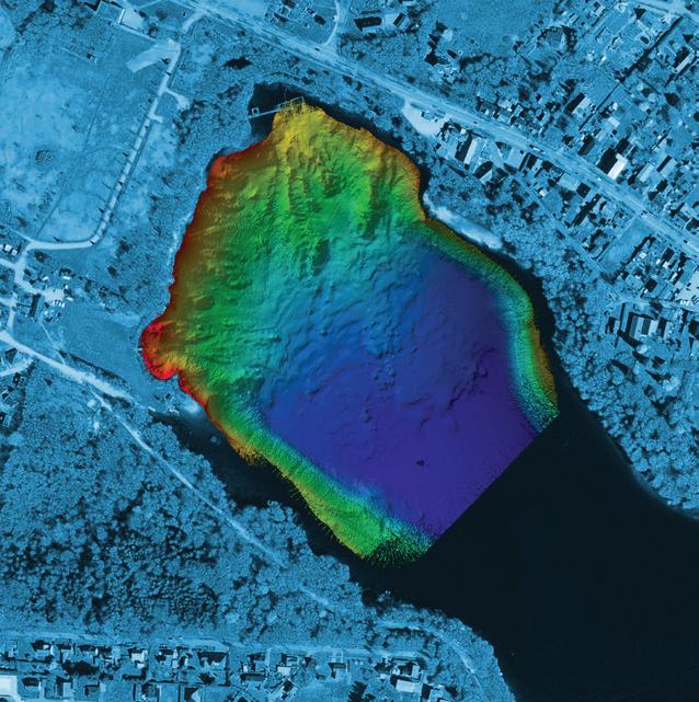
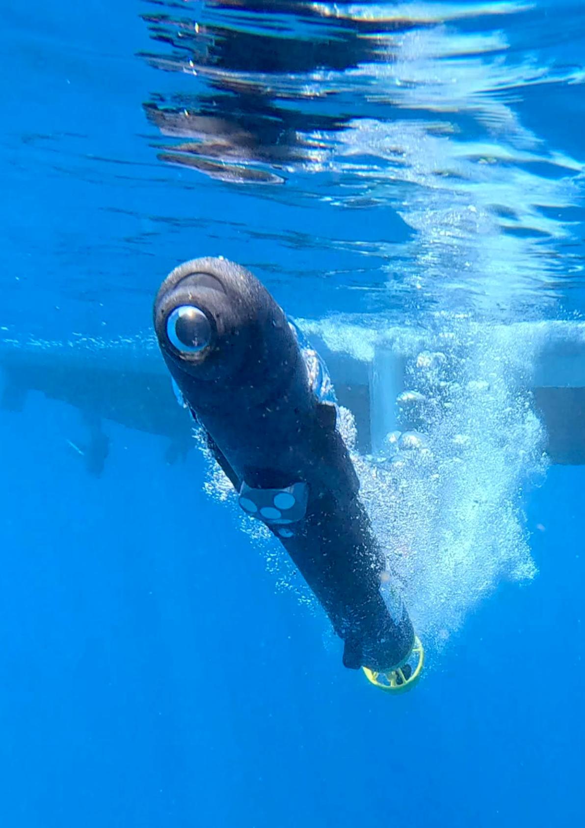
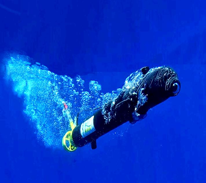
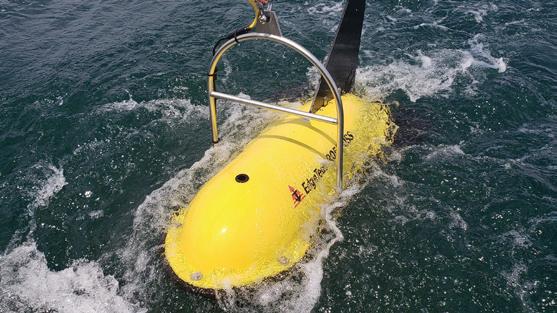
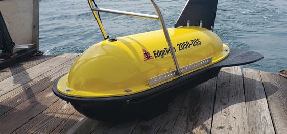
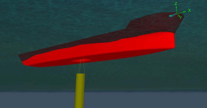
ecoSUBm5-Power+ SCOUT, with DVL, 4K camera and Side Scan Sonar, getting down to business


Modus has changed its name to Manta. The technology company provides solutions for marine autonomy.
It offers subsea services such as seabed mapping, pipeline inspection, photogrammetry and 3D visualisation as well as geophysical and environmental surveys.
At the centre of its autonomy ecosystem is the hovering autonomous underwater vehicle (HAUV) MantaRay, a fully electric vehicle with six degrees of freedom that can be tailored to perform a wide range of operations, such as surveying, infrastructure inspection, and ocean bottom node seismic acquisition. The Saab Seaaeye AUV is not to be confused with the Manta Ray AUV offered by Northrop Grumman.

Unmanned Survey Solutions has changed its name to Uncrewed Survey Solutions (USS). The company builds and operates its own fleet of Uncrewed Surface Vessels (USV), and delivers customised marine data collection projects and missions primarily across the hydrographic and geophysical domains.

Ashtead Technology has acquired Seascan Limited and its subsidiaries (known as Seatronics), and its sister
company J2 Subsea Limited, the international subsea electronics and ROV tooling rental and services businesses, for £63m, from Acteon.

CMS GeoScience Ltd (CMSG) has purchased of a new site in Falmouth, Cornwall, marking a significant milestone in the company's ongoing development.
The Gables will support their operations and enhance research and development of new equipment. CMSG already working on building new laboratories and storage facilities for their equipment.

VideoRay has been acquired by Blue Halo, a leading provider of next-generation capabilities to support critical defence and national security missions.
This is a strategic move that will define the future of global submersible robotics technologies and solutions and offer you even more capabilities–backed by the most advanced, reliable technology available.
Earlier, BlueHalo announced that it had been acquired by AeroVironment (AV), a company involved in all-domain defence technologies. That deal is not expected to be finalised until sometime within the first half of
2025. Until that transaction is complete, BlueHalo (with VideoRay as a wholly owned subsidiary) and AV will continue to operate as separate, independent companies.


SeeByte and Kraken have signed a Memorandum of Understanding (MOU) to enhance their complementary system offerings to bring customers an integrated solution across maritime mission planning, data collection, and data analysis. Kraken specialises in the delivery of advanced synthetic aperture sonar (SAS) for maritime platforms including uncrewed underwater vehicles of all sizes and the KATFISH towed SAS system.

SeeByte specialises in the development and supply of maritime software solutions including their SeeTrack Mission Management System (MMS), Neptune Autonomy and Automated Target Recognition, Impact Subsea has appointed M2Ocean Solutions to service the Canadian market.
This collaboration marks Impact Subsea’s second distributor in Canada, further solidifying its commitment to serving the region’s subsea industry.

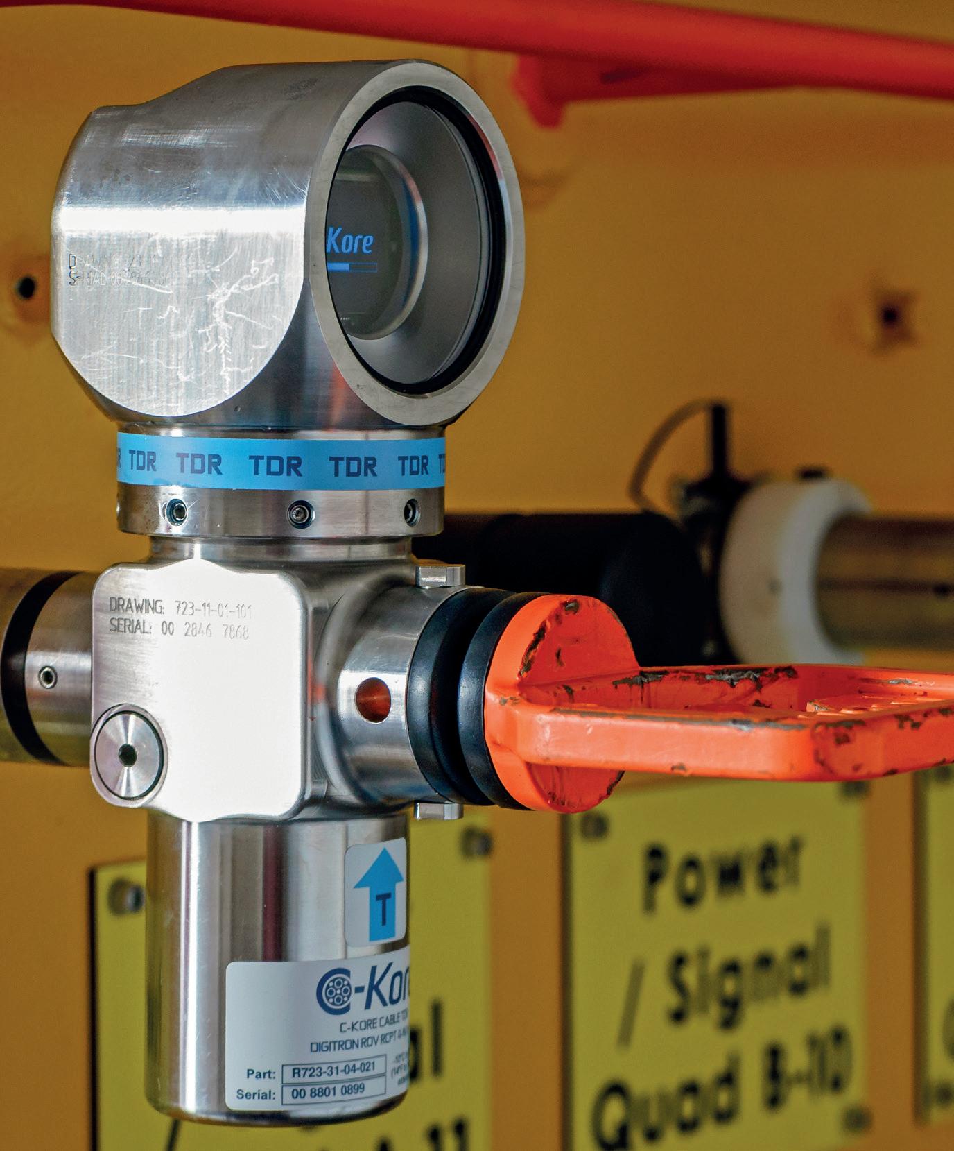
C-Kore’s patented test tools automate the entire testing process, achieving significant cost savings. It’s safe for use on all subsea infrastructure, giving you better data much faster without extra personnel.


Teledyne Valeport has received a substantial investment from NOR Offshore Rental (NOR). NOR has expanded its equipment pool with a selection of Valeport precision instruments, including theBathy 2,Midas SVX2,miniSVS,miniIPS2, andModel 106. General Oceans, has acquired ocean technology specialists RS Aqua.
RS Aqua has over 40 years experience of supplying ocean technology sensors and systems across a variety of sectors and are a leader in their field. Based in Portsmouth, UK, RS Aqua occupy a strong position within the UK underwater technology market.
Motive Offshore has acquired Aquatic. The deal will increase Motive’s rental fleet and provide a full back-deck offering globally. Motive will undertake Aquatic’s operations in the UK, Singapore, the US, Australia, and Norway, marking a significant milestone in its global growth strategy.
Bolstered by investment from H2 Equity Partners in 2022, the acquisition aligns with Motive’s continued ambitions to target strategic locations, diversify its rental fleet, and generate 75% of revenue from renewables by 2025.

Hydroacoustic technology manufacturer GeoAcoustics has appointed No Humes as its first Channel Partner dedicated to the
Australian and New Zealand markets.
GeoAcoustics now has more than 50 Channel Partners serving customers in 69 countries. The new channel partner agreement covers the entire GeoAcoustics portfolio of bathymetric sonars, side scan sonars and sub-bottom profilers.

Greensea IQ has announced the successful completion of field testing IQNS edge processing and navigation system on the VideoRay Defender ROV. For the demonstration, Greensea IQ worked closely with Water Linked AS, integrating the IQNS with the DVL A125 to create a standalone underwater navigation solution.
The ecoSUB team were invited to collaborate with Sonardyne International to deliver the Smart Sound Demo Day in September 2024.
Smart Sound is a proving ground for the design, testing and development of cutting-edge products and services for the marine sector. It has benefitted from a substantial investment in underwater navigation and communication technology, supplied by Sonardyne, and also has access to ecoSUB Autonomous Underwater Vehicles, provided by partner organisation Plymouth Marine Laboratory and University of Plymouth.
Sonardyne were keen to showcase the capability of the USBL, LBL and underwater communications services now available in Smart Sound. ecoSUB Robotics were asked to provide a demonstration of AUVto-AUV communications and to show how underwater navigation could be aided by the USBL system in situ. The team all agreed to run this as a live demo to an audience monitoring remotely from Plymouth Marine Laboratory’s Smart Sound Lab.
To meet this challenge, the ecoSUB team decided to run a force-multiplier mission, or ‘Leader / Follower’ mission. Only one ecoSUB AUV would be given a mission, another vehicle would be deployed with a Backseat Application that would listen through its Sonardyne AvTrak 6 Nano acoustic channel
for messages from a Leader vehicle. The Leader vehicle would begin its mission and immediately start broadcasting an acoustic message every 10 seconds that contained its position (lat/long) and its heading.
When the Follower vehicle receives this message, it applies a line spacing offset and calculates its own mission on the fly to track a parallel line to the Leader vehicle.
Behaviours were embedded for handling heading changes (turns) and also potential loss of coms with the Leader vehicle, to ensure robust and safe operation. Both AUVs would benefit from USBL
ecoSUB underwater
aided navigation available in the Smart Sound range.
The ecoSUB team wrote the Backseat Application in advance of Smart Sound Demo Day, but testing of the whole system was limited to a very short window during the two days prior to the demo. With only parts of the system tested to check operation of the acoustic coms, it was a Hackathon style activity that showed the flexibility and ability of ecoSUB AUVs to be dynamic and versatile systems.
With the live link to the remote audience established, both vehicles were promptly deployed from Sonardyne’s Echo Explorer

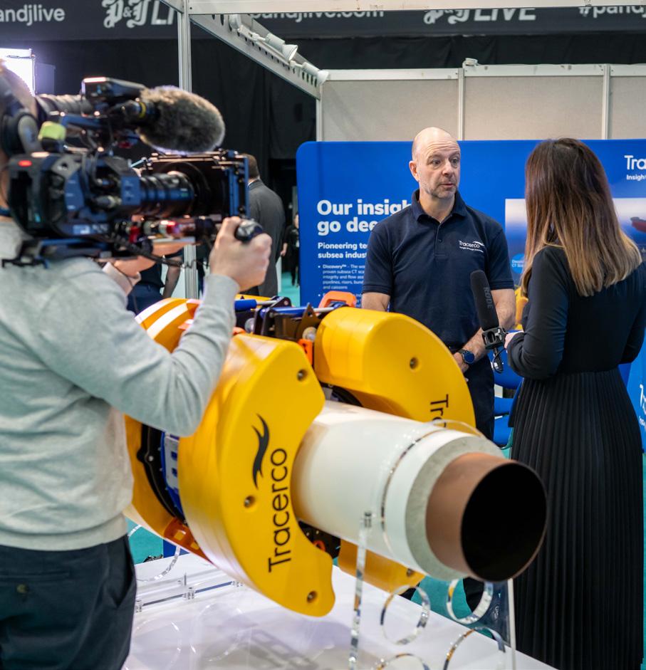
Providing 3D visualization with 14m diameter and 50m deep cores, Kraken’s Acoustic Corer surveys identify geohazards and stratigraphy, ensuring efficient, risk-free offshore foundation design and installation.

Kraken Robotics | Underwater. Understood.™
www.krakenrobotics.com
vessel, and immediately went into action. The Follower vehicle went straight into a loiter mode, circling at a depth of 20m, waiting for an acoustic message, the mission on the Leader vehicle was then started and it dived to its target depth, and started to broadcast messages.
Watching the live USBL tracking, the land-based delegates of the Smart Sound Open Day watched the Leader vehicle start to follow its programmed mission track, and then saw the Follower vehicle successfully receive the required to two messages from the Leader vehicle and it move out of its Loiter behaviour.
At this point an issue in concept design was uncovered. The Follower vehicle had been launched and sent underwater very quickly – unfortunately, the result of this was that it had not
acquired a good GPS fix, and localised itself outside of the mission area – the vehicle began a transit to the Leader vehicle, but from a false position.
When a USBL position was received, the vehicle did correct and the mission adapted, but by this stage, the delivery of two vehicles working in parallel was missed. Overall, the concept worked and the AUV-to-AUV coms was shown to be successful – a bit more time and patience would have seen a very successful mission.
Fortunately, the ecoSUB team can’t resist a good learning opportunity and since September’s hard-lesson-learnt, they decided to address some of the limitations of GPS, and have designed a new helical antenna, dedicated to GNSS that provides multi-constellation, fast
acquisition, and uses a Trimble BD9992 board that can provide RTX Centrepoint position correction, offering the ecoSUB platform centimetre accuracy in minimal time, greatly enhancing surface position capability.
–––GNSS feeds directly into an INS on board that fuses multiple sources of localisation situational awareness, including DVL velocities and USBL position.
ecoSUB AUVs continue to advance in the delivery of highquality mission and data collection for users benefiting from this pioneering, and yet very affordable technology.
The ecoSUB team would like to thank the support and collaboration between Sonardyne International, Plymouth Marine Laboratory and the University of Plymouth.
C-Kore Systems has deployed its 900th subsea testing tool! This significant milestone was reached with a mobilisation for a major operator in Brazil, monitoring umbilical installations during a prestigious campaign.
C-Kore’s subsea testing units have gained worldwide acceptance with both operators and contractors for the cost-savings the tools provide, the reduction in offshore personnel required for testing, and the simplification they bring to subsea operations.
The impact C-Kore’s tools and services are having on the global subsea testing market are significant. Having worked on over 125 different subsea fields across more than 20 countries, C-Kore have amassed extensive knowledge in subsea testing. Their latest product, the new subsea optical TDR tool is rapidly becoming a favourite among customers, offering the unprecedented capability to test optical lines directly subsea, setting a new standard in the industry.
Cynthia Pikaar, Sales and Marketing Director of CKore commented,” The deployment of our 900th
ecoSUB Robotics, a leader in innovative autonomous marine robotics, recently participated in Oceans 2024, marking the company's first exhibition outside of the UK.
During the event, many attendees had the opportunity to see ecoSUB's AUVs up close for the first time, having followed the company's developments from afar for several years. underwater exploration.
C-Kore unit in Brazilian waters is a testament to the hard work and innovation of our team.
Brazil is a key region for offshore energy production, and we are committed to continuing to deliver cutting-edge solutions that meet the evolving needs of our clients in this vital market.”
Its deployment in Brazil highlights the growing demand for reliable and efficient subsea testing solutions.
In addition to showcasing its products, ecoSUB Robotics is excited to announce the appointment of a new distributor to cover the Canadian market.
Teramara, formerly known as DASCO, has been an established player in Canada for several years and recently underwent a rebranding to better reflect its commitment to innovation and excellence in marine technology. ecoSUB looks forward to working
closely with the Teramara team to expand its reach and support in Canada.
Electric Manipulator
• Seven function work class manipulator
• Compatible with most work class ROVs
• Maximum reach 1,990mm
• Lift capacity 122kg/454kg (max/min reach)
• Precise position and force feedback
• Modular self-contained joints
• Wrist camera option
• Diagnostic power and status LEDs
• Interchangeable parallel and intermeshing jaw options
• On-board processing for advanced kinematics
saabseaeye.com
The ocean covers 71% of our planet, representing the largest ecosystem on Earth. In this, around 2,000 species are discovered annually, — a figure that hasn’t changed significantly since the mid-1800s.
The Ocean Census has been set up as the largest programme in history to discover life in the ocean.
It was founded by the Nippon Foundation, the private, non-profit foundation for social innovation, and Nekton, a UK-based marine science and conservation institute, but this is the peak of a vast number of science , expedition, data and technology partners.
This alliance runs expeditions to provide opportunities to discover ocean life and accelerate our global mission.
“We’ve only discovered 10% of ocean life of maybe 2.2 million marine species,” said Oliver Steeds, Director of Ocean Census.
“The group however is heralding a new era of pioneering research and scientific exploration to accelerate species discovery and protection.
“Recent technological advances in high resolution imaging, DNA sequencing and machine learning mean scientists can now massively accelerate the process.
“We have set an ambitious target of finding at least 100,000 new marine species in the first decade”.
This expedition was carried out in polar regions with an average depth of 1000m although sometimes the seafloor was nearer 6000m, thus requiring specialised submersibles.
Led by The Nippon Foundation-Nekton Ocean Census Alliance, UiT (The Arctic University of Norway) and REV Ocean with its ROV Aurora, the project brought scientists from 15 leading academic institutions to research and document this under-explored region
The area encompassed a diverse range of deepsea landscapes including the Knipovich Ridge, Dumshaff Abyssal Plain, Jøtul vent field, Svyatogor Ridge, Alta Seamount and Molløy Deep
MID OCEAN RIDGES
Mid-ocean ridges are vast underwater mountain ranges that can stretch for 60,000km. Life around the slow-spreading Knipovich Ridge in the Arctic Ocean thrives in extreme conditions, with organisms adapted to survive near hydrothermal vents and cold seeps, including deep-sea corals, chemosynthetic ecosystems, and endemic species of benthic fauna.
Hydrothermal vent Image: REV Ocean
Hydrothermal vents habitats eg, in the Jøtul Field of the Arctic deep sea, are superheated, mineral-rich water emerges from cracks in the ocean floor, often near volcanic or tectonic activity. These vents are typically found at depths of 2000–4000m along mid-ocean ridges, where the Earth’s tectonic plates move apart. The water, heated to temperatures as high as 400°C, interacts with surrounding rocks and becomes enriched with chemicals such as hydrogen sulphide
Hydrothermal vent communities depend on chemosynthesis, where microbes convert these chemicals into energy. This forms the foundation of a unique food web, supporting chemosynthetic species like bacteria, which in turn, gives energy to a wide range of species of tube worms, gastropods, isopods, sea spiders and specialised fish.
Cold seeps, like those found near the Svyatogor Ridge, are unique deep-sea habitats that do not emit superheated water as hydrothermal vents do, but instead, release methane at much lower temperatures. Despite the cold and extreme conditions, these habitats support thriving communities of organisms.
Cold seeps are often found near continental margins or areas with tectonic activity, such as mid ocean ridges. The ecosystems here are slower-growing than those at hydrothermal vents, but they are equally vital in helping scientists understand the deep ocean’s biodiversity and geochemical cycles.

Studying cold seeps provides insight into carbon storage, methane cycling, and the adaptation of life to extreme environments, all of which have important implications for both ecology and climate science.
Abyssal plains are vast, flat deep-sea habitats, typically found at depths between 3000–6000m. These plains are covered in fine sediments that have slowly accumulated from the remains of marine organisms, volcanic ash, and dust from the atmosphere.
These environments are home to a diverse range of specially adapted life forms, such as deep-sea fish, worms, sea cucumbers, and microorganisms. The ecosystems rely on “marine snow”, a steady drift of organic matter falling from upper ocean layers, as
NOW 3000m RATED
• Versatile: Tri-Frequency Side Scan to cover a range of applications
• Capable: Towfish based CHIRP Sub-bottom profiler to deliver higher resolution data
• Loaded: Built-in pressure (depth), heave, pitch and roll sensors
• Flexible: Support for 3rd party sensors
a primary source of food. These plains also play a crucial role in global geochemical cycles, acting as storage zones for carbon and other elements.
Although sampling the water column was not a main focus on the Arctic Deep expedition, it still provided incredible insights from the ROV Aurora
The deep water column refers to the vertical zone of ocean water that extends from just below the surface layer, down to the abyssal depths and often reaching several thousand metres. The deep water column is characterised by complete darkness, cold temperatures, and increasing pressure as depth increases.
Life here has evolved remarkable adaptations to survive in these extreme conditions. Organisms such as fish, squid, and jellyfish are common, using bioluminescent abilities to navigate, hunt, and avoid predators in the dark.
The deep water column plays a critical role in global nutrient cycling, carbon storage, and the ocean’s overall health. Despite its vastness, much of this zone remains unexplored, offering enormous potential for scientific discovery.
The Ocean Census joined Schmidt Ocean Institute on its ‘High Seas and Seamounts of the Nazca Ridge’ expedition. Off southern Peru’s coast, it is a poorly explored seafloor area with rugged terrain, including seamounts, trenches, canyons, and guyots.
Many experts in marine protection and policy believe that the Nazca and Salas y Gómez Ridges are a top priority for designation as one of the world’s
Ocean Census Philippine Sea aimed to explore the Kyushu-Palau Ridge and Minami-Daito Jima Island areas in the north western Pacific.
As part of the wider JAMSTEC Ocean Shot Expedition, led by the Japan Agency for Marine-Earth Science and Technology (JAMSTEC), the Ocean Shot Research Grant, and NHK TV.
The expedition used the 100.5m R/V KAIMEI, one of the world’s most advanced research vessels, equipped with state-of-the-art laboratories and submersibles.
Minami-Daito Jima Island is the largest island in the Daitō Island group southeast of Okinawa, and saw the majority of the research focus. The Kyushu-Palau Ridge is a 2,600-km-long area extending north–south at the centre of the Philippine Sea south of Japan. Home to a chain of extinct volcanoes,
One of the most innovative aspects of the upcoming expedition will be the use of two ROVs operating in tandem to explore and catalogue the deep-sea limestone cave systems and their unique biodiversity,
first high-seas marine protected areas.
The R/V Falkor used advanced technologies to collect comprehensive seafloor mapping data. The science team also integrated and test several new pieces of equipment on the ROV SuBastian, including a state-of-theart channel oxygen logger called a mini Trace analyser in situ logger, or mTail, a new camera with a 3rdperson view of SuBastian and new specialised sampling jars.


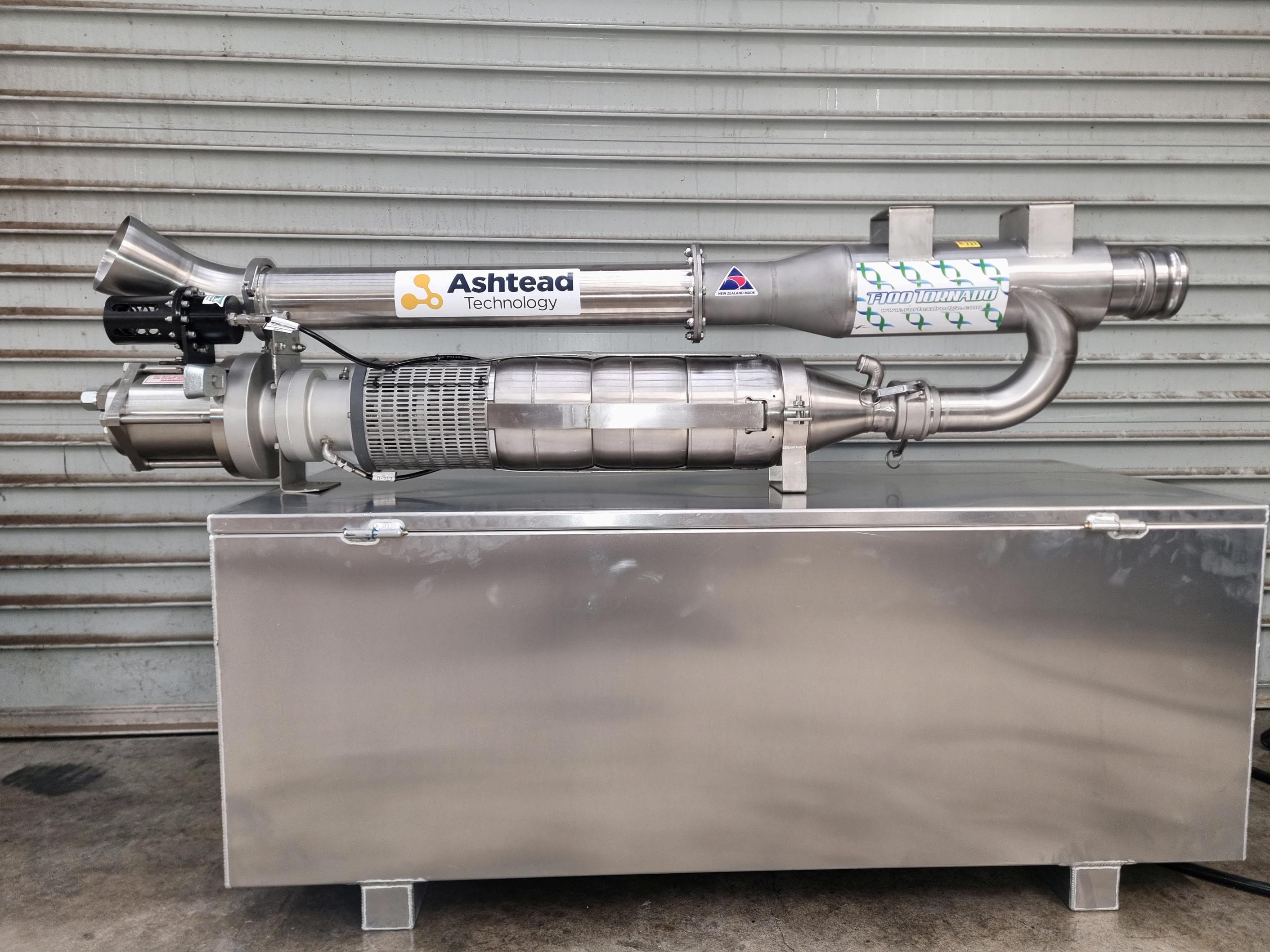
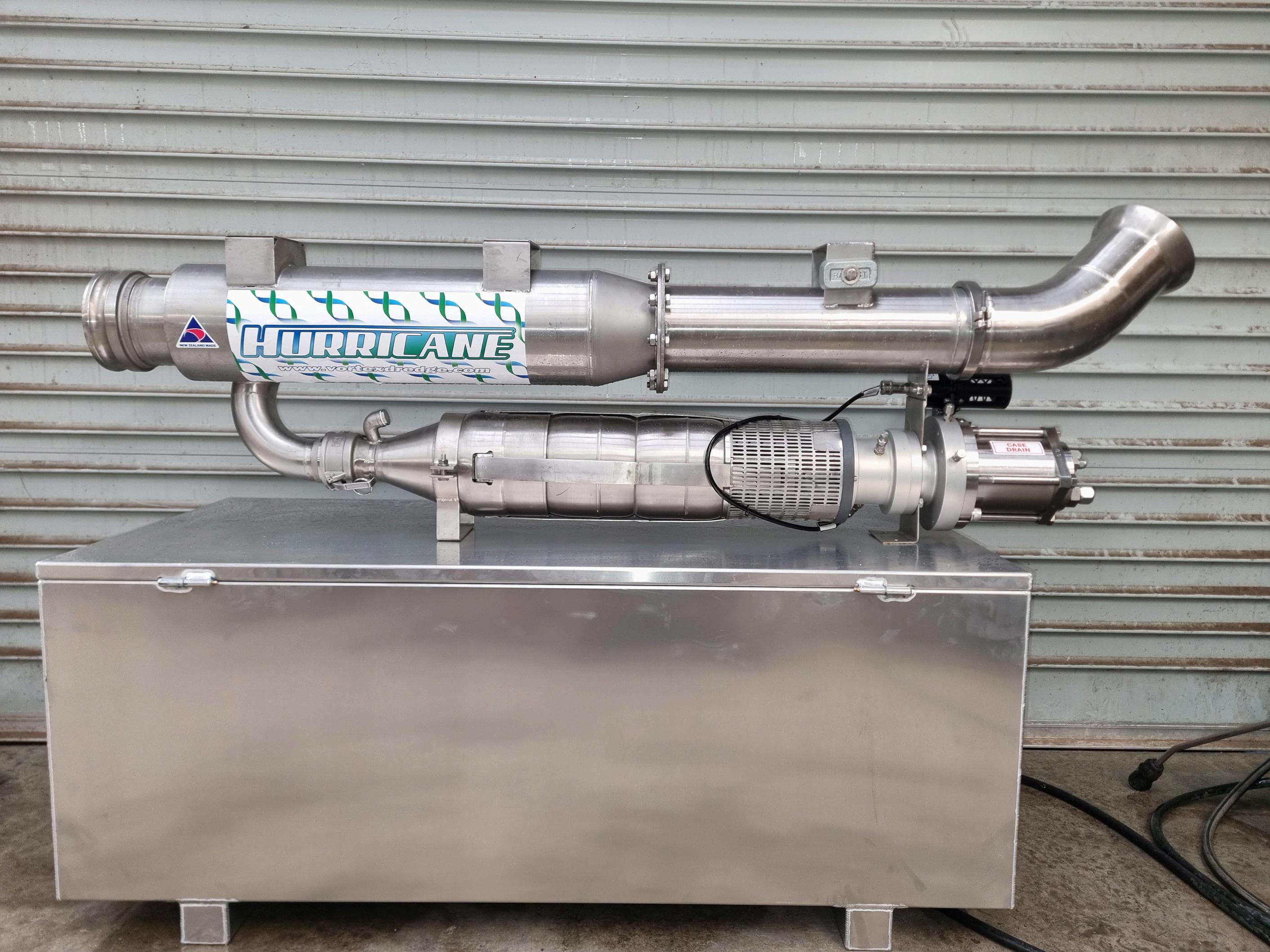
Vortex has just released their water / glycol powered 4 and 6 inch dredge build to run on the Schilling GEMINI WROV platform and any other water / glycol hydraulic system.
Using the same power motor and pump to maximise efficiency and suction performance this tool adds further capabilities to the GEMINI with day-to-day tooling such as dredging that give the ROV more work scope flexibility
Suction capabilities 4 inch - 70 kpa using 162lpm (43 GPM) @ 206bar (3000psi)
Suction capabilites 6 inch - 40 kpa using 162lpm (43 GPM) @ 206bar (3000psi)

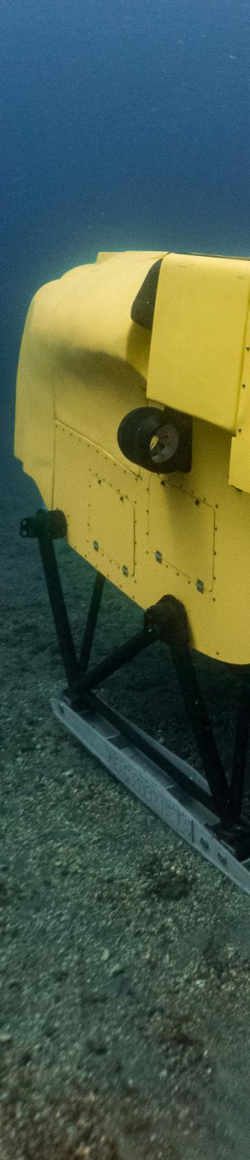
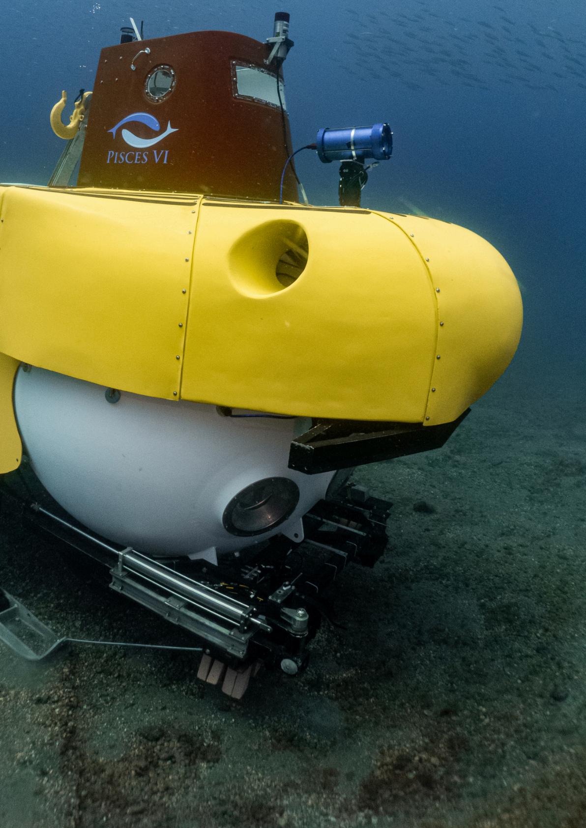
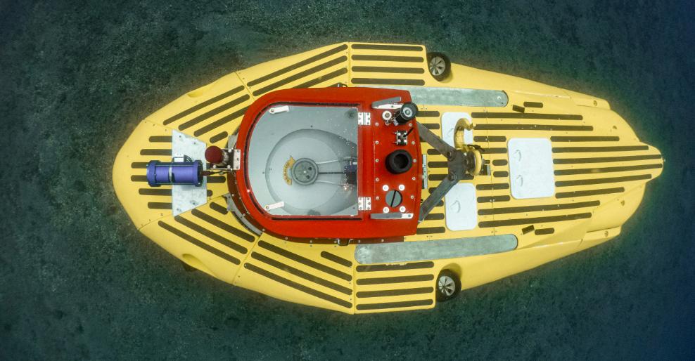
In the early days of the offshore industry, when ROVs were in still their infancy, most underwater intervention was performed by Human Occupied Vehicles (HOVs) such as submarines and submersibles. One such was the Pisces built by International Hydrodynamics Corporation (HyCo).
At the time, Pisces 1 to 11 were all operating. Up until recently, however, only Pisces 4 and 5 were still operating. Now, the Pisces 6 has been resurrected.
“It has been so deeply renovated, that the only original parts are the round steel pressure hull and the variable ballast tanks,” said Scott Waters, President, Pisces VI Submarine. “The Pisces VI hull was fabricated from a special steel called HY100 which has good strength properties.
“All the Pisces hulls were built in Canada, except for this one - the steel came from Germany and machined in Switzerland and it can go deeper than all the other Pisces.
“The Pisces VI was designed for 2500m. We have the certification for 2180m because the pressure tank at SWEIRI couldn't go to 2500m at that time.
“It was originally built for oil inspection, but its first job was actually looking for nuclear waste off of California. It then worked as an inspection vehicle on Twin Drill a catamaran drilling ship.
In the early 1980s, when the oil industry receded, it went into storage but in 1986 and 1987, it was used to conduct scientific research for National Geographic. It then returned to storage where its certification lapsed.
“We stuck a deal with owners International Underwater Contractors and moved the vehicle from the indoor storage facility in New York, to Green Bay, Wisconsin. We then carried out a five-year refit in Kansas to bring it up to modern-day technology standards. It was then shipped it to Canada for testing in Vancouver before taking it to our Canary islands base. DSV Completed Depth (ft) Crew
IX Unbuilt 8300 3 PISCES X 1976 3300 3 PISCES XI 1976 6500 3
“The electronics, fibreglass structure and the manipulator are all completely new.”
Inside, the Pisces VI has one pilot and space for two passengers –the same configuration as almost all the other super deep-diving scientific vehicles.
The sphere has been tested and certified for four people, but this is deemed as unpractical and so it generally accommodates three.
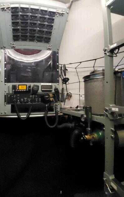
Behind to the sphere lies the battery banks as well as the gas bottles for breathing and supplying the main ballast. At the very back, there are a number of variable ballast tanks which are used for trim.
The Pisces VI is it is the only Deep submergence vehicle (DSV) able to be shipped very inexpensively anywhere in the world in a shipping container rather than on a dedicated ship. It is also the only DSV which leaves no drop weights on the ocean floor allowing it to work in marine protected environments.
“When the submarine is underwater we may want to adjust our buoyancy, particularly if we need to pick up samples and this may make us a little heavy,“ said Scott Waters. “We just pump a water out of those tanks and this gives us fine control.
“At the very top of the vehicle is the entry hatch which is protected by the ‘sail’.
Passengers normally either enter the vehicle from here when on a ship or land but if we need to do this at sea, this fairing affords protection, particularly when encountering high winds and large waves. It is free flooding, allowing any water to exit from a scupper valve to allow people to get in and out safely.”
In front of the sail, there is a camera.
“We have a few different kinds of cameras we can use,” said Waters “but the main camera is a 4K unit with the internal
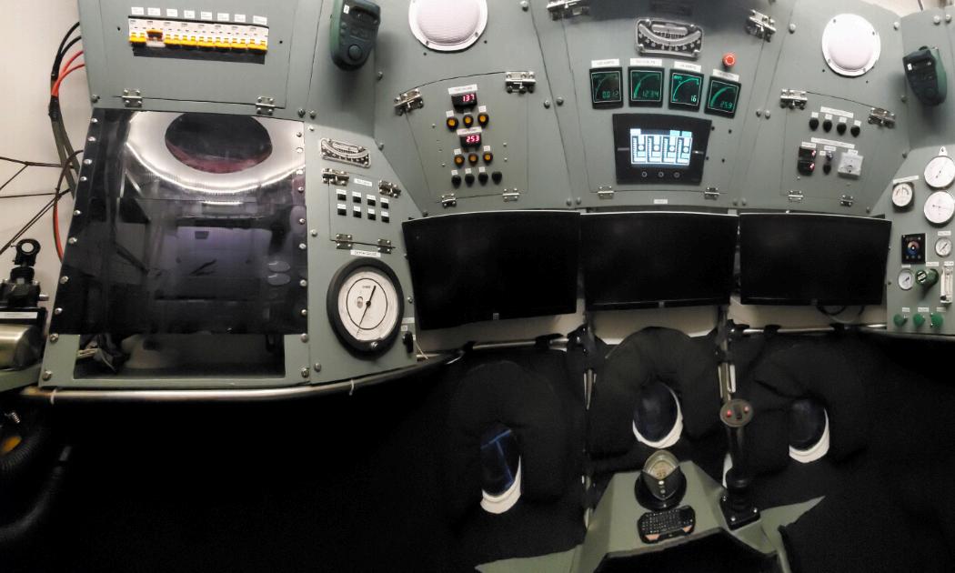
components supplied by Blackmagic and built into a pressure sphere. It is certified for 2500m.
“Sometimes, the vehicle has a science basket attached to the front of the sub, which we can
configure for every dive.”
The main purposes of the Pisces VI is for scientific research although it can be used for other applications such as creating films, search and recovery, archaeology and even if necessary, for tourism.
At end of last year, it carried out a ‘new species‘ mission with Ocean Census and year it worked on a film with French TV where it surveyed deep water corals.
“Going forward, we are looking at for fisheries in between Iceland and Norway,” said Waters. “In the 1990s, the fisheries collapsed and it was really devastating for the economies of Iceland, Norway and the Faroe Islands.
Stocks are now coming back but there has been really little scientific research about the original cause and many want to understand what happened.
One theory is that as the area is often used for dragnet fishing,
and this possibly destroyed a lot of the coral reefs. When this happens, it eliminates the small life and the food chain collapses.”
What's the advantage over other underwater vehicles?
“There are some times where an AUV is better, some applications where an ROV is better, some times where an HOV is better, while sometimes, sending dumb sensors down like landers is a good idea,” said Waters.
“AUVs are a great tool for mapping while ROVs have manipulation and stay down for long periods of time. All are very valid tools. With underwater exploration, however, you almost always discover something that you weren't expecting and that's where a human-occupied submarine is particularly valuable.
“You can see how the species interact with each other and get a global appreciation that remote cameras rarely provide. The HOV is the best tool for certain kinds of science but just one tool in the toolbox of scientists.”
Each year, around 8-12 million tons of plastic and 2.3 million tons of oils are released into the seas and oceans. In 2016, the Frenchbased company Interactive Autonomous DYnamic Systems (IADYS) was set up to develop services around the Jellyfishbot, a small autonomous vehicle designed to collect floating pollutants in rivers, yachting marinas, ports, shipyards seas and oceans.
“In 2017, there was one ton of plastic for every five tons of fish in the ocean and if nothing is done, there will be more plastic than fish by 2050,” said Dr. Nicolas Carlesi, lADYS's founder and CEO. “Every year, an additional 8-12 million tons of plastic and 2.3 million tons of oils end up in the seas and oceans.
“In addition to this, other forms of pollution (oil, metals, green algae, etc,) are now accumulating in our oceans. Numerous regulatory measures have been adopted to prevent the discharge of waste into the environment, but despite these measures, the quantities discharged are still too great.
Carried away by rain, wind or simply discharged through negligence, they end up in inland water bodies, rivers and then out to sea
In November 2024, lADYS raised US$11 million to further develop its robotic products and expand its reach among industrial companies. It is intending to enhance its range of pollution control solutions by introducing a docking station for its robots
deployed at industrial sites and a system for collecting geolocated samples.
At the same time, the upcoming opening of an office in Houston, Texas, will allow the company to expand its presence in this key market and provide local logistical and technical support to industries equipped with the Jellyfishbot and Mobile Oil Skimmer (MOS).
The Jellyfishbot comes in four versions, the Vision, Horizon, Abyss and Infinite, each with progressively more features but all remotely controlled, containing autonomous geolocation and having a surface HD camera, with 120° horizontal angle to allow the operator to steer towards the pollutant.
The vehicle measures 70 cm x 70 cm with a height to 58 cm. Its small size allows it to treat the most inaccessible places, between boats or under pontoons. It has a draft of 23cm and weighs 23kg. It is constructed of a polythene aluminium alloy.
The vehicle is powered by a pair of 14.4 V Lithium ion batteries that are housed within the catamaran floats. In autonomous mode, these power the vehicle for up 17 hrs although in manual mode, this is reduced from 2 to 8 hrs. The batteries have a total recharging time of 3.5 hrs
(although they are 80% charged at 2hrs). Each of the batteries has a capacity of 30Ah and a lifetime of 500-800 cycles.
As the Jellyfishbot moves forward at a speed of 1kt (2kt maximum), it funnels the trash between its catamaran hulls and into a towed collector net behind. These nets have a capacity of 70 to 80lit.
The surface operator can communicated with the vehicle over a Wi-Fi or over a 3G or 4G signal for the smaller models ( 5G for the more advanced vehicles). The vehicles contain their own GPS facilities.
The Horizon and Infinite models are able to avoid surface static obstacles, while the Abyss and Infinite can also avoid underwater static obstacles by using a forward pointing submerged sensor. The latter vehicles can also conduct depth measurements up to 20m.
The Jellyfishbot can also be used as part of a mobile oil spill
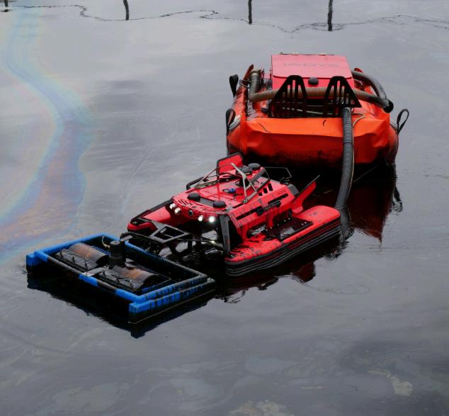
response system. A skimmer system can be attached to the front of the Jellyfishbot Expert or Expert + to collects the oil. It works by means of spinning drums that turn at a speed regulated by the remote control
Removable fastening system for nets, underwater equipment
Jellyfishbot’s features
Jellyfishbot at the centre of an oil skimming system
system. This feeds oil into the storage platform that is towed behind the Jellyfishbot.
The skimmer is 43cms long and 66cms wide , standing 30cms tall. It weighs anything between 9-20bls and can collect 5-15lit/ min. It is powered by its own battery, which can be charged in 2.5 hrs.
The oil is fed back through a pipeline to the towed storage platform. This is 1.5 m long, 90 cm wide and 64 cm high, it weighs 40-88lbs. Its tank has a capacity of 120lit but there is an automatic shut off when the storage platform is full. It takes only five minutes to drain.
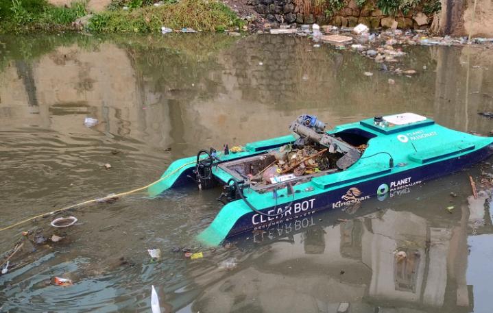
Clearbot was established in 2019 as a student project to help Indonesian surfers clean up waterways efficiently.
At the time, paddle boats and nets were still the most practical solution in the region which left locals ill-equipped to deal with the trash flow.
Since then, it has expanded into pollution recovery able to clean trash, oil and invasive weeds, surveillance and rescue, survey and with its payload of 200 kg, even cargo delivery.
“As our Clearbots run on electric battery power, they can be charged entirely with solarpower, allowing them to sail with zero carbon emission while resulting in a 10X lower fuel cost,” said co-founder Sidhant Gupta.
“The entire fleet can be operated remotely from any site office globally while our real-time data retrieval and cloud based post processing results in faster data availability.”
Clearbots offer three models.
The smallest is the 1.3 m-long Fetch. It has a payload of 17lit, expandable to 50lit and its battery life can last two hours with a 2– 4 hr charging period. It has an average speed of 2kts and a range of 5 km.
The larger Class 2 vessel is 3m long and has a payload capacity of 200 kg. It has a battery life of 8hr and can be recharged in 4–6 hrs. It can work at speeds at 3 kts and has a range of 5 km.
The largest in the Clearbot range is the Class 3. This has a payload of 500kg and has a battery life of of up to 8 hrs. It has a charging time of 6hrs. The vehicle has an average speed of 3 to 10 kts.
For efficient recharging, the company has developed a floating solar charging dock. Solar panels on the roof can recharge the vehicles although it can also run on grid electricity. If required, however, batteries can be swapped on site in under 10 minutes.
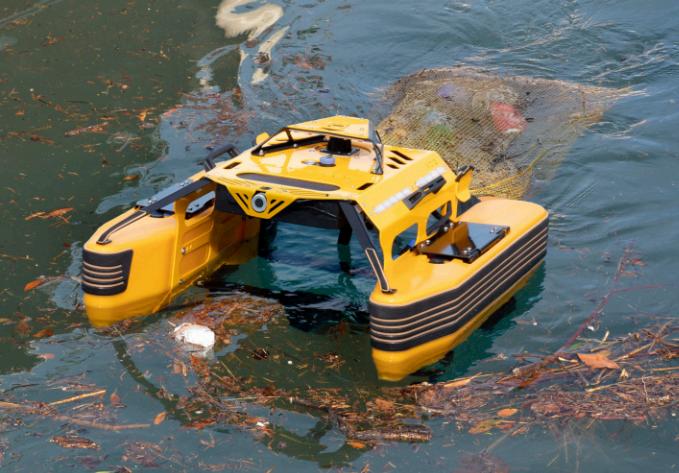
Drawing inspiration from the whale shark - the world's largest fish species known for its distinctive front-mounted mouth and filter-feeding behaviourRanMarine Technology has developed an innovative solution for floating water pollution: the WasteShark autonomous surface vessel (ASV).
This aquatic drone mirrors its marine namesake's efficient filtering capabilities, but instead of plankton, it collects floating debris like plastics, trash, algae or biomass from waterways. The WasteShark's compact yet powerful design allows it to access confined spaces where trash typically accumulates, while still maintaining significant waste collection capacity.
various water environments.
portal.
The vessel's specifications are impressive: measuring 166cm (65in) in length, 118cm (46,5in) in width, and 62cm (24.5in) in height, the 72kg (159lbs) craft is propelled by dual electric thrusters, each generating 4.1kg of force.
Operating at a maximum speed of 3km/h, the WasteShark can run continuously for up to 8 hours in autonomous mode, capable of
Structurally, the WasteShark employs a catamaran design with a centrally mounted collection basket between its twin hulls. The steel or aluminium baskets can store up to 160l (42gal) of waste each trip and can be easily removed to dispose of the waste.
The robust platform houses temperature and depth sensors and can be fitted with up to an addition of 15 sensor arrays to measure things like nitrates, dissolved oxygen levels, pH, turbidity or conductivity. Data is
The WasteShark can be operated in two manners, firstly in manual mode via a remote control and on-board camera, allowing operators to target specific areas for waste collection or data gathering in real-time. In autonomous mode the ASV operates along pre-programmed routes, which can be saved and repeated as needed for systematic cleaning operations.
The ASV is equipped with LiDAR technology for collision avoidance and obstacle avoidance, ensuring safe operation in busy waterways. Advances in Artificial intelligence (Ai) are now been explored to actively target floating trash using the vessels front facing camera.
While the WasteShark excels in precision cleaning of smaller waterways, RanMarine has expanded its portfolio with the MegaShark, a larger electric
A proven method of cleaning waterways and capturing plastic waste from rivers while still allowing ships to pass freely, is to use a bubble curtain. The system is broadly analogous to the bubbler curtains used to reduce noise from offshore piling.
One company active in this area is the Great Bubble Barrier. A self-sinking, flexible, steelreinforced EPDM tube is laid diagonally across the seabed. An air diffuser allows air pumped into the tube to escape as small bubbles. This creates an upward current which directs plastic to the surface and into the catchment system.
This diverts waste into a catchment system, a floating 7m x 3m x 1,5m structure constructed from Marine grade aluminium. This contains a ISO bag for trash storage . An optional solar powered remote monitoring system records caught debris and the continuous monitoring of weather conditions
INVISIBUBBLE
InvisiBubble uses a bubble barrier that can purify water deflect sediments, remove hydrocarbons and preserve fauna. It uses Bubble Tubing, a flexible linear diffuser, generating micro-bubbles and limits eutrophication.
Eutrophication is the process that occurs when a body of water becomes enriched with nutrients, leading to excessive growth of algae and plants
The company says that with aeration, the body of water is de-stratified and oxygen becomes available to aerobic bacteria in the sediment. This Increases oxygen levels in the water, avoids stratification, and produces less odour and stagnant water. It also limits excessive nutrient loads in the water (less plants and algae.
vessel 450cm x 225 cm (14.8 ft x 7.4ft) designed for more demanding environments. This mid-sized platform combines onboard operator capabilities or remote control options, making it suitable for industrial-scale cleanup operations.
The MegaShark distinguishes itself with enhanced waste handling features, including a reverse thrust system and mechanical basket lift for efficient debris offloading. Its sophisticated 4G connectivity also enables real-time monitoring and data collection, while maintaining the same commitment to zero-emission operation as its smaller counterpart.
The presence of both platforms in RanMarine's fleet offers a comprehensive approach to water cleanup, with the WasteShark handling precise, autonomous operations in confined spaces, while the MegaShark tackles larger-scale waste management challenges that require direct operator intervention and greater collection capacity. WasteShark and collector
Engineering Roboticists at the Max Planck Institute for Intelligent Systems in Stuttgart have developed a jellyfishinspired underwater robot which could potentially be used to collect waste from the ocean bottom.
The Jellyfish-bots prototype are almost noise-free and can trap objects underneath their body without physical contact, thereby enabling safe interactions in delicate environments such as coral reefs. Jellyfish-Bot could become an important tool for environmental remediation.
Electrohydraulic actuators work as artificial muscles to power the robot. Surrounding these muscles are air cushions as well as soft and rigid components which stabilise the robot and make it waterproof.
Electricity periodically runs
through thin wires, causing the muscles to contract and expand, allowing the robot to swim gracefully and to create swirls underneath its body.
"When a jellyfish swims upwards, it can trap objects along its path as it creates currents around its body ,” said Tianlu Wang, a postdoc in the Physical Intelligence Department at MPIIS. “In this way, it can also collect nutrients.
“Our robot, too, circulates the water around it and this is useful in collecting objects such as waste particles. It can then transport the litter to the surface, where it can later be recycled. It is also able to collect fragile biological samples such as fish eggs. Importantly, there is no negative impact on the surrounding environment”.
"70% of marine litter is estimated
to sink to the seabed,” continued colleague HyeongJoon Joo. “Plastics make up more than 60% of this litter, taking hundreds of years to degrade. Therefore, we saw an urgent need to develop a robot to manipulate objects such as litter and transport it upwards.
“We hope that underwater robots could one day assist in cleaning up our oceans."
Each robot works faster than other comparable inventions, reaching a speed of up to 6.1 cm/s.
Moreover, Jellyfish-Bot only requires a low input power of around 100 mW and it is safe for humans and fish should the polymer material insulating the robot one day be torn apart.
The noise from the robot cannot
Arms
Image: Max Planck Inst
be distinguished from background levels allowing the Jellyfish-Bot to interact gently with its environment without disturbing it.
The robot consists of several layers: some stiffen the robot, others serve to keep it afloat or insulate it.
A further polymer layer functions as a floating skin. Electrically powered artificial muscles known as HASELs are embedded into the middle of the different layers. HASELs are liquid dielectric-filled plastic pouches that are partially covered by electrodes.
Applying a high voltage across an electrode charges it positively, while surrounding water is charged negatively. This generates a force between positively-charged electrode and negatively-charged water that pushes the oil inside the pouches back and forth, causing the pouches to contract and relax – resembling a real muscle.
HASELs can sustain the high electrical stresses generated by the charged electrodes and are protected against water by an insulating layer. This is important, as HASEL muscles were never before used to build an underwater robot.
The first step was to develop Jellyfish-Bot with one electrode with six fingers or arms. In the second step, the team divided the single electrode into separated groups to independently actuate them.
"We achieved grasping objects by making four of the arms function as a propeller, and the other two as a gripper", said Hyeong-Joon Joo. “We actuated only a subset of the arms to steer the robot in different directions.
“We also looked into how we can operate a collective of several robots. For instance, we took two robots and let them pick up a mask, which is very difficult for a single robot alone. Two robots can also cooperate in carrying heavy loads.
“At present, our Jellyfish-Bot needs a wire which is a drawback if we really want to use it one day in the ocean but we aim to develop wireless robots," continued Tianlu Wang. “Luckily, we have achieved the first step towards this goal. We have incorporated all the functional modules like the battery and wireless communication parts so as to enable future wireless manipulation.”
Theattached a buoyancy unit at the top of the robot and a battery and microcontroller. They then took their invention for a swim in the pond of the Max Planck Stuttgart campus, and successfully steered it along.
Aquatic ecosystems face anywhere between 4.8 to 23 million tons of plastic infiltrating water systems each year.
Traditional methods of cleaning water surfaces are labourintensive, inefficient and often inadequate for the complexities of varied environments. These approaches typically rely on manual labour –skimming debris, collecting trash, and using basic cleaning boats.
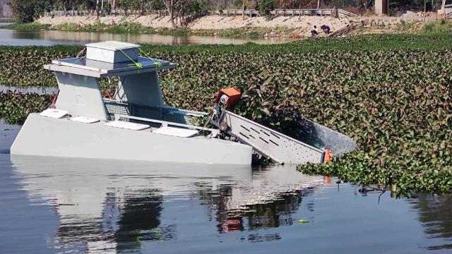
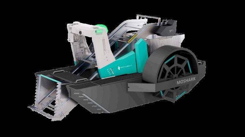
Orcauboat has developed the Smurf water surface cleaning robot which is equipped with advanced features such as garbage recognition, debris collection, security patrols, and water quality monitoring.
It was recently used in complex rivers in Singapore, which featured artificial revetments and diverse geological conditions. SMURF effectively tackled physical debris, sediment, and algae.
SMURF is a high density garbage container for small particles collect, which can cleaning along the edge and cleaning in the area after automatically route planning.
The application of SMURF in the canal in Singapore obviously improved the efficiency of cleaning and the security the surroundings.
Another application was the lake
One problem with blocked water ways is not discarded rubbish, but submerged plants which cause blockages. These require surface mowing systems
One vessel that Orcauboat produces to control the growth is the Moshark which can
Adjustable harvesting depth
One machine for multiple usesaquatic plants removal, water quality monitoring and surface water cleaning
the water is mainly composed of leaves, foam and other floating debris,” said a source. “After the SMURF was put into use, it greatly improved the efficiency and decreased the cost of daily
“The intricate layout of harbours demands advanced intelligence for efficient cleaning, especially during nighttime operations. ORCAUBOAT's autonomous technology allows SMURF to expertly navigate tight spaces, autonomously returning to its dock for recharging. This capability ensures continuous
service, meeting all-weather demands and fully realizing the potential of intelligent, unmanned operations.
Hull Size: 2927 1763 1080m
Material: Aluminium Alloy
Weight: 155kg
Capacity: 50kg
Draft Depth: 0.47m
Op Speed: 0.8-1m/s
Max Speed: 2.2m/s
Charging Time: 7h
Battery Runtime: 6-8h
harvest All types of submerged plants.
It measures 4000 in length, 2500 in width and has a height of 1930mm, or even longer with the standard extension arm. It is fabricated for my high strength aluminium alloy which gives the
vehicle an unlaid and weight of 1100kg.
It can accommodate loads of up to 150 kg. It can be charged in 5 Hours and has a battery life of 8 hours and has a draft depth 0.4m It has a maximum speed 1.5m/s and a Rated working speed of 1m
lifting and lowering of garbage baskets
Professor Dr Ingo Grevemeyer, marine geologist at the GEOMAR Helmholtz Centre for Ocean Research Kiel, is currently leading a research team to investigate the Oceanographer Transform Fault Zone, located southwest of the Azores.
The METEOR cruise M204, the second of six planned TRANSFORMERS expeditions, hopes to gain new insights into the seismic activity and geological processes at this largely unexplored plate boundary.
“The surface of our planet is shaped by large tectonic plates,” explained Grevemeyer
“Ocean research has traditionally focused on the movement at mid-ocean ridges where new seafloor is formed, or subduction zones where the Earth's crust dives into the Earth's interior. “
The third type, oceanic transform faults (where two tectonic plates move sideways past each other) has until now, been considered less important.
Stresses can also build up at these boundaries and be released in earthquakes. However, transform faults have only about 15% of the theoretically expected earthquake rate. Why there are fewer earthquakes than expected is an open question in the study of oceanic transform faults.
THE SIGNIFICANCE OF OCEANIC TRANSFORM FAULTS
The geodynamics of transform faults is the focus of METEOR expedition M204.
“Transform faults were previously regarded as conservative plate boundaries, because no seafloor is created or consumed there,” explained Grevemeyer. “However, recent research suggests that these structures are more complex – they could actively
contribute to the formation of new crust and involve more complicated geological processes than previously thought.”
Two key questions will guide the scientific team during the expedition.
First, why do deep valleys form along transform faults when the spreading rate is low? Can the extension be traced by earthquake processes? Second, why are transform valleys deeper than neighbouring fracture zones?
Could this be due to additional magmatic activity before the transform faults become inactive fracture zones?
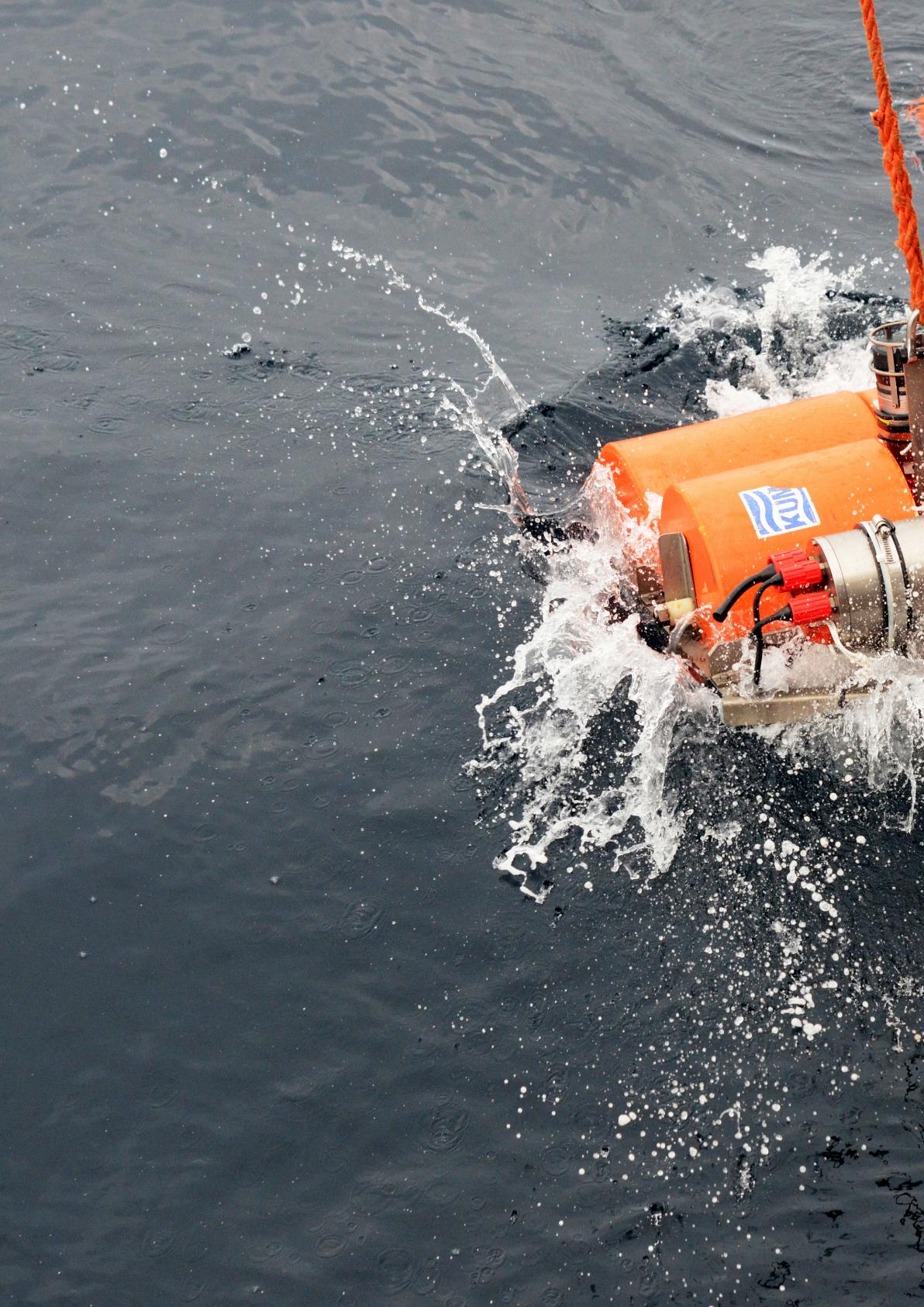
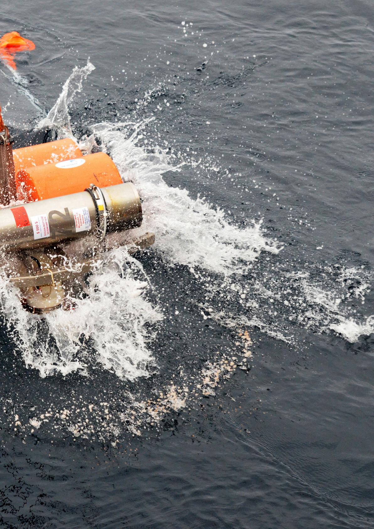
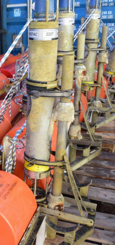
To answer these questions, ocean bottom seismometers and geodetic stations were deployed on the seafloor during the MSM122 expedition of the research vessel MARIA S. MERIAN a year ago.
These instruments will now be retrieved during the M204 expedition. Over the past year, they have recorded the seismic activity of the fault zone, providing valuable data on the tectonic stresses in the region.
In addition, geothermal and magnetic measurements will be conducted to determine the exact structure and activity of this seismically active fault.
This is the second in a series of six research cruises in the TRANSFORMERS project, which is funded by the European Research Council with €2.8 million. Over the next five years, a team of researchers led by Prof. Dr Grevemeyer will work to reassess the concept of oceanic transform faults and update the theory of plate tectonics.

At the recent meeting of the Hydrographic Society timed to coincide with the MATS event in Southampton one of the speakers, Geraint West of Sonardyne, discussed how new techniques are revolutionising our understanding of the tectonic movement of the earth.
Tectonic plates are part of a dynamic earth movement process. This consists of new oceanic plate material moving outward from the mid-ocean trenches and being drawn under denser continental plates in subduction zones. Plate movement is normally in the order of a few centimetres a year – ca. 10cms at most.
At times, however, these plate margins ‘stick’ resulting in locking, which can lead to the build-up of enormous pressure over time. This energy is at risk of being suddenly released in the form of earthquakes and consequential tsunamis, such as the 2004 ‘Boxing Day’ and 2011 Tohuku Tsunamis. Understanding these margins is therefore critical to scientists’ ability to assessing submarine earthquake and associated tsunami risk.
Ashore, geodesy – the measurement of the earth’s shape - has become routine due to the maturation of space-based technologies, including GPS, very long base interferometry (VLBI) and satellite laser ranging (SLR). Unfortunately, all of these techniques are useless below the
surface of the sea. Consequently, developments over recent years, to enable equivalent subsea measurements, have started to revolutionise scientists’ understanding of deformation mechanisms at the seabed and their ability to model them.
Geraint, says that this revolution, “Is based on applying two techniques/technologies originally developed for the oil and gas industry,” and offshore surveyors will instantly recognise the principles of these:
‘Direct Ranging’ is based on long baseline (LBL). In this case, instead of positioning a vehicle within an LBL array, the measurement of the ranges between the transponders themselves is automated to produce frequent relative measurements over a local area of a few km. GEOMARHelmholtz Centre for Ocean Research Kiel have shown accuracies of between 0.2 – 1.2 cm/km for projects, which have used this technique.
GNSS-Acoustics (GNSS-A) applies the acoustic ‘box-in’ technique and by undertaking averaged observations over several days, it’s possible to achieve world geodetic frame positioning to centimetre-level. Repeating these observations periodically then yields absolute measurement of changes in seabed position. GNSS-A was first developed by Scripps Institution of Oceanography in the 1980s; however, projects at
scale were limited by the lack of commercial off the shelf instruments and the cost of shipbased operations.
The key to unlocking the potential of these two techniques has therefore been dependent on two emergent technologies: seabed transponders capable of deployment in several km of water for many years, and uncrewed surface vehicles v(USV) to make these operations economically viable. Indeed, Scripps have estimated using a USV reduces operational costs to
AMT After Etna RecoveryDr Morelia Urlaub, GEOMAR
about 1% of that of a modern research vessel.
In response to these challenges, Sonardyne developed the Autonomous Monitoring Transponder (AMT) and its longendurance relative, the Fetch subsea sensor node, as well as a modular GNSS-A payload for Liquid Robotics’ Wave Glider USV. Derived from Sonardyne’s 6G Compatt transponder, AMT and Fetch are designed for long endurance seabed deployments, and some versions of Fetch have battery capacity for more than 10 years.
Their integrated high-speed telemetry enables both offloading of data from the seabed at rates up to 9,000 bps, as well as reconfiguration of instruments insitu. On the surface, Sonardyne’s GNSS-A payload comprises dual GPS antennas integrated with an attitude sensor and acoustic transceiver, fitted to the USV’s skeg.
Nevertheless, although these methods have demonstrated capability to measure horizontal (XY) displacement, vertical (Z) motion is more challenging, due to the drift characteristics of pressure sensors, which can be similar in magnitude to the vertical motion being measured.
Once more recent technical advances are providing solutions, and Ambient-Zero-Ambient (AZA) in-situ pressure calibration is now a proven technology. Sonardyne have been at the forefront in
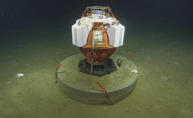
NCSZO Fetch Deployed – Ocean Exploration Trust / Ocean Networks Canada / University of Victoria’
operationalising this and are now supplying an AZA version of Fetch to meet this need. But that’s another story in itself…
Direct ranging and GNSS-A projects are now routine with multiple deployments ranging from the Pacific to the Mediterranean:
Using direct ranging, GEOMAR measured underwater slippage of Europe’s largest and most active volcano, Mount Etna, for the first time. Over recent decades, satellite observations have shown the southeast flank sliding towards the sea at rates of up to 50 mm per year. The largest displacements have been observed at the coast; however, it was previously impossible to measure displacement of the submervged flank.
Therefore in 2016, GEOMAR deployed an array of five AMTs in about 1,200m water depth. Three were on the presumed unstable flank and two on the adjacent stable slope. Measurements during a 15-month period confirmed that the entire flank of the volcano is in gravity-driven motion. In one event, the slope slipped about 4 cm in just eight days. These results indicate that there is a greater risk of flank collapse than was previously thought. Consequently, the array continues to operate to this day.
In the case of GNSS-A, at the time of writing, GNSS-A sites are in operation off New Zealand, Alaska/ Aleutian Islands and the North America Pacific Coast from British Columbia to Southern California.
A significant component is the North Cascadia Subduction Zone Observatory (NCZSO). An initiative of the University of Victoria’s Ocean Network’s Canada, in collaboration with Pacific Geoscience Centre and Scripps, the NCSZO comprises seven GNSS-A sites deployed in 4003,000 m water depths offshore Vancouver Island since 2021.
v These sites are designed to provide measurement of the undisturbed motion and deformation of the Juan de Fuca Plate, as well as deformation of the overridinvg North America plate. An onshore network of geodetic stations, operated by Natural Resources Canada provides reference for movement of the seabed sites.
To sum up, as Geraint concluded in his talk, “Seabed geodesy is being taken up by an increasing number of scientists with their sights set on the prize of new and critical insights into seabed deformation. The aim is to use these to better understand how to mitigate the impact of some of the most damaging natural phenomena known to our world.”
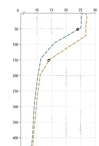
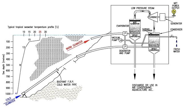
In tropical oceans, the heat from the sun warms the water’s surface layer to a temperature that sometimes exceeds 25°C depending on location.
The deeper water column, however, features a thermocline, in which temperatures decrease with depth. At about 1000m down, the temperature drops to nearer 4°C.
Although there are some seasonal variations, this approximate temperature difference is preserved all year round.
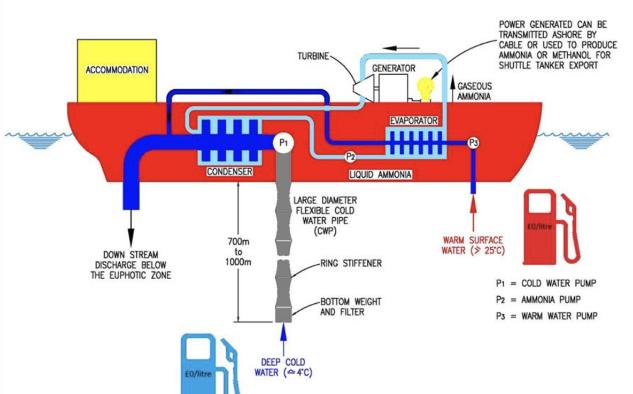
It is this temperature difference that OTEC production units
exploit to produce electricity. The idea behind the concept is that warm seawater causes a low boiling point liquid, eg, ammonia, to turn to vapour.
In general, there are three main types of OTEC power generation systems, namely:
(a) Closed cycle (CC) OTEC (b) Open cycle (OC) OTEC (c) Hybrid OTEC, basically a combination of a) and b).
Warm surface sea water is passed through an evaporator (heat exchanger).
On the other side of the heat exchanger membrane is a working
Schematic of Floating Closed Cycle OTEC (Image: M. Brown,OESL)
fluid such as the ammonia, which vaporises at low temperatures. The resulting ammonia vapour expands and the pressure drives a turbine connected to a conventional electricity generator.
After passing through the turbine, the expanded vapour is condensed back to a liquid using a second heat exchanger, cooled by cold deep-ocean water. The liquid ammonia is then pumped back to the warm water heat exchanger and the entire process can be repeated.
Potential OTEC Image:Energise Magazine/Brown
Because the temperature difference between surface and deep sea-water is relatively small, the thermal efficiency of the OTEC process is inevitably low, "however, since the ocean thermal resource is massive large quantities of warm and cold water can be processed.
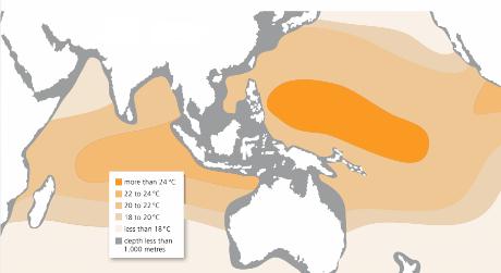
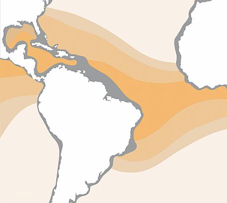
• The central and western Pacific Ocean has an annual average temperature difference of above 24°C and countries in this region, such as Indonesia, Malaysia, the Philippines and many Pacific Island countries can obtain deep cold water in nearby offshore water
• The east coast of Central America in the western Atlantic and the coastal areas around the Gulf of Guinea have good thermal gradients. Countries in this region such as Mexico, Brazil and some African countries are also well suited for developing ocean thermal energy resources.
• The islands of the Caribbean, the east coast of the Indian Ocean, and the South China Sea, as well as countries such as India and China also possess suitable conditions for developing ocean thermal energy.
In general terms, an adequate temperature difference between the surface and sub-surface layers can be found in the tropical oceans between 23 degrees north to 23 degrees south. This potential area is equivalent to nine Sahara Deserts, and the Sahara Desert itself is almost the size of Europe. Using conservative assumptions, the maximum power output is estimated at 8,000 GW
For a large floating unit the US Department of Energy has sponsored designs of 400MW capacity.
In OC-OTEC, a warm seawater stream is partially
vaporised inside a flash chamber kept under a high vacuum condition using a pump.
This water vapour, in a desalinated state, expands inside a large diameter lowpressure turbine and generates mechanical power, which drives a generator to produce electricity. The vapour is then condensed using cold seawater.
The condenser is kept at a lower pressure than the flash chamber due to the gas to liquid phase change. The pressure difference between the flash chamber and the condenser provides the driving force for the vapour to flow towards the condenser via the turbine.
If a surface rather than a spray condenser is used valuable freshwater can be produced as part of the electricity generation process.
Land Based Open Cycle (OC) OTEC including Fresh Water Production (copyright, M. Brown, OESL)
A key benefit of OTEC is reducing dependency on fossil fuels, particularly for small island developing states (SIDS), contributing to greater energy security.
Unlike intermittent renewable energy sources such as wind and wave, OTEC can provide continuous base-load power because ocean temperature differences are stable and predictable throughout the day and year.
Plants can be designed to scale from small (for localised energy needs, such as remote island communities) to large-scale floating plants that can serve larger populations or industrial operations.
Relatively small (circa 1-5MW) land based plants are possible for
typically volcanic islands where deep water is in close proximity to the shore
OTEC systems rely solely on the ocean’s thermal energy, emitting no CO ₂ or other pollutants. They occupy very little land, especially compared to solar or wind farms and this reduces its environmental footprint on coastal ecosystems.
The warmed, but still cool water, is returned to the ocean at a suitable depth to suit local conditions minimising ecosystem disruption. For floating OTEC operations the nutrient-rich deep seawater promoted the growth of phytoplankton and in doing so, results in carbon dioxide reduction in the atmosphere
DESALINATION:
OTEC plants can also generate fresh drinking water through the desalination process as a byproduct of electricity generation.
This is especially beneficial for waterscarce regions. Such systems have been installed on a number of islands off the coast of India. The nutrientrich cold water from the deep ocean can also be used foraquaculture and mariculture, promoting local economies by supporting fisheries and marine farming.
Continuous electricity generation can be used for hydrogen production through electrolysis, contributing to clean fuel generation for transport and industrial use.
“A number of different floating liquefied natural gas (FLNG) plants have been proposed by various organisations, e.g. Shell, FlexLNG, Bluewater, Teekay, etc,” said Martin Brown MD/ Consultant Naval Architect at Ocean Energy Systems.“
“FLNG provides a means of exploiting remote or stranded gas fields which are too far from an existing market for the gas to be transported economically by pipeline.
“Scale flaring of gas is no longer an environmentally acceptable solution for the extraction of crude oil. Therefore, FLNG systems are receiving significant attention from both energy companies and contractors.
“The actual process of cooling and liquefying natural gas is very energy intensive. The overall production rate can be increased by approximately seven per cent by using 10 °C cold ocean water for cooling, as opposed to warm surface seawater.
Such a significant increase in output has a very significant environmental and economic value. From an OTEC viewpoint FLNG provides a mechanism to provide vital operational performance data on the cold water delivery system.
FLNG systems could act as a vital stepping stone in the development of large-scale floating OTEC systems.”
OTEC plants may be integrated with existing marine infrastructure, such as offshore platforms or deep-sea research facilities, creating synergies that reduce operational costs and promote joint-use facilities for power generation and research.
Some proposed OTEC systems can synthesise liquid ammonia: as a hydrogen carrier which• can be exported by ammoia shuttle tankers similar to oilexport from FPSOs.
With regular maintenance, welldesigned OTEC systems can have long operational lifespans, especially since the primary components (heat exchangers, turbines, and seawater pumps) operate in a stable environment. Advances in materials like corrosion-resistant alloys and composites further enhance the durability of these systems.
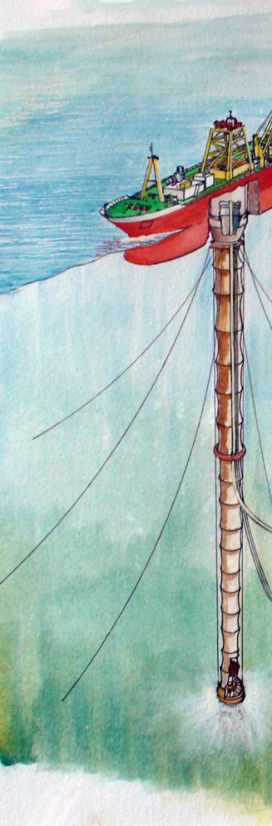
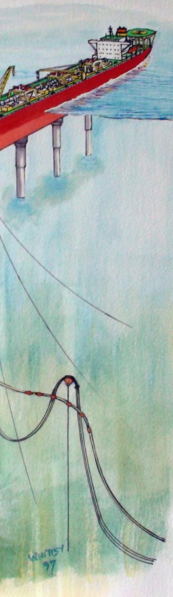
From a technical point of view the most challenging aspect of OTEC is the installation and long-term reliable operation of a large diameter cold sea-water intake pipe.
This also ties into the economic feasibility, since a single large diameter pipe is cheaper than a bundle of smaller pipes. In addition, there is less warming of the cold deep sea-water in a large diameter single pipe and fewer frictional losses than a a bundle of several smaller pipes, improving net power output.
To address this uncertainty a “Cold Water Pipe (CWP) Joint Industry Project (JIP)” is being launched by Ocean Energy Systems Limited of Aberdeen and LabOceano (Ocean Technology Laboratory at COPPE/University of Rio de Janeiro.
The figure below shows a new design of motion-decoupling top joint between the top of the CWP and the supporting OTEC hull. The CWP is hung off the midships centreline of a monohull so as to minimise the impact of roll and pitch of the hull.
This is like an oil and gas Drillship where the drill string is typically deployed from the ship’s midships on the centre line.
The proposed three-point support allows the CWP to deflect in current and when the hull surges and sways. The three hang off lines minimise the loading of the CWP when the
Snapshot of an Orcaflex Simulation in an Irregular Quartering seas with a Significant Wave Height (Hs) of 10.8m
hull heaves up or down in longer period waves.
Hence no complex and energy consuming heave compensation system is required. A flexible membrane at the top of the CWP makes the pipe water-tight.
This new joint along with other devices, such as gimbals, will be analysed numerically and then in the Ocean Test Basin to hopefully confirm that design predictions are matched by test tank behaviour. Success in the tank is planned to lead on to at sea tests in Brazil’s Campos Basin utilising existing FPSOs.
Successful demonstration of large diameter CWPs could open up OTEC to initial niche markets such as Power Barges to supply electricity to help minimise the carbon emissions from existing FPSOs. Mass production of OTEC Power Production Barges will bring down costs such that there will be other markets for OTEC generated electricity.

The cutting-edge vehicle engineered to navigate all environments swiftly and securely

"Experience the power of our state-of-the-art vehicle with standard front and rear HD cameras. Equipped with a 7 thruster, vectored system, a 15.6” LCD display monitor, and a 12.1” LCD touchscreen control monitor, this vehicle can reach speeds of up to 3.5 knots and operates at a depth of 1,000’ (305m). Its commercial-grade design ensures reliability and performance."
An idea that has been around for over a century, with a few successful demonstrations globally, may be the next generation of renewable energy for Small Islands Developing States (SIDS) and coastal nations.
Originated in the 19th century by French physicist Jacques Arsène d'Arsonval, who envisioned the first practical cycle in 1881, Ocean Thermal Energy Conversion (OTEC) consists of harnessing the untapped potential of the ocean temperature gradient to generate electricity.
The technology is ideal for SIDS as the ocean is their largest natural resource and there is a desperate need for clean alternatives for power generation. Viable in over 100 territories in the tropical area of the ocean, OTEC has currently two noncommercial onshore demonstrations in Hawaii, USA, and Okinawa, Japan.
Having faced a lack of interest over recent decades, due to cheap oil and the prioritisation of other renewables, this technology is now ready for a new start, thanks to the UK-based company Global OTEC
Focusing on island nations that are almost completely powered
by polluting and expensive fossil fuels, the company found a solution to reduce the costs and adapt the technology, by scaling down the structure and positioning it offshore.
This innovation has not only reduced implementation costs but also tailored the technology to meet the specific needs of SIDS, which often lack land space for wind and solar, for example. “Islands are calling for technologies which are appropriate for the specific challenges and opportunities of
their geographies”, details Global OTEC Founder and CEO Dan Grech.
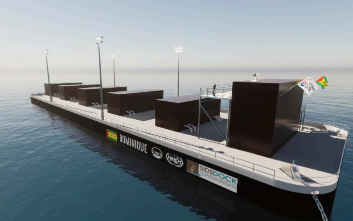
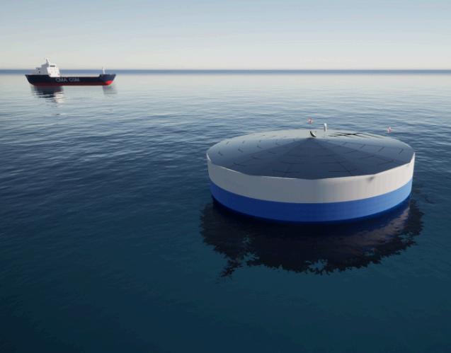
Its first-of-a-kind floating OTEC platform is named Dominique and will be installed in São Tomé and Príncipe, in the Gulf of Guinea, Africa.
With a net capacity of 1.5MW, Dominique represents a major leap in clean electricity generation for SIDS, aiming to replace the costly diesel generators and address the energy needs of over 600 million islanders.
The commissioning is slated for the end of 2025, with the current development phase being a national and international stakeholder engagement process to analyse the results of a scoping study for an Environmental and Social Impact Assessment (ESIA) and to develop the Terms of Reference (ToR) for a full ESIA and Environmental and Social Management Plan (ESMP).
This was contracted by the United Nations Industrial Development Organisation (UNIDO) to Aqualogus Engenharia e Ambiente Lda, a Lisbon-based engineering consultancy.
Following this step, a seabed survey will be conducted, which can be followed immediately by detailed design and procurement of key offshore components.
Global OTEC's plans extend beyond the African twin islands, with countries like Belize, Fiji, Grenada, and Tonga already signalling the intention to replicate the success of the firstof-a-kind.
Over the past year, the company achieved important milestones, with Approval in Principle (AiP) from Lloyd’s Register (LR) for the OTEC platform and Certificate of
1. The barge draws in warm surface seawater (of around 26°C) which has been heated by the sun’s rays
2. This warm water is used to evaporate a working fluid with a low boiling point
3. This produces a vapour which spins a turbine to produce electricity using a generator
4. At the same time, cold deep water (of around 4°C) is drawn up through a pipe from the depths of the ocean
5. The cold water cools the vapour, turning it back into a liquid which can then be immediately reused
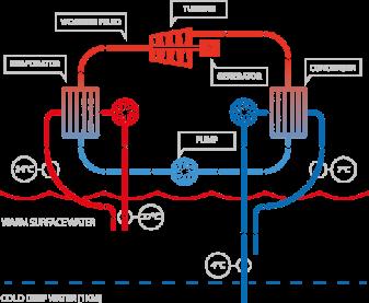
6. The cycle runs continuously whilst the power generated is transmitted to the grid using a sub-sea cable
Approval for the Cold-Water Riser installation methodology, which has long been a challenge for previous offshore OTEC platforms. Issued by Marine Warranty Surveyor company ABL Group, this certification holds particular importance given OTEC's historical technical challenges.
These early validations
underscore the company's commitment to meeting structural prerequisites.
“Deepwater oil and gas technology has done an amazing service to OTEC by de-risking many of the systems and subsystems needed to not only station keep but to supply a large quantity of cold deep water to floating production facilities”, adds Grech.
The company utilises a closed cycle, employing ammonia as the working fluid and navigating pressures from 10 to 6 bar, ensuring reliable power output through the perpetual cycle. In the pursuit of its commercial OTEC platform, Global OTEC integrates several turbines atop a robust steel hull for efficiency.
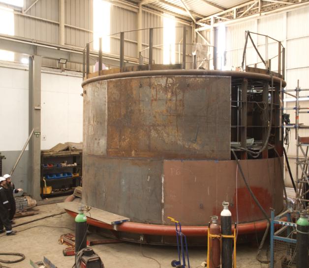
The platform's dimensions are approximately 90m x 28m x 5.5m, a footprint significantly smaller than what the equivalent solar PV installation would require. November last year, at the International Vienna Energy and Climate Forum (IVECF), the company revealed advanced concepts of Dominique, based on the operations of a gridconnected OTEC test facility, emphasising its continuous efforts to enhance functionality and cost-effectiveness.
A solution for OTEC in severe tropical weather regions
One of the biggest challenges that tropical islands face is related to severe weather events. With a geography that makes them more vulnerable to hurricanes, cyclones and typhoons, they often are left without power for weeks.
As electricity is essential to recover after a disaster, these countries need energy solutions that are not only clean but also climate resilient.
Addressing this specific need, an
EU-funded project is developing an offshore OTEC structure that can face severe tropical weather.
Named ‘PLOTEC’ and gathering seven partners across Europe (Global OTEC, Agru, Cleantech Engineering, University of Plymouth, PLOCAN, WavEc, and Quality Culture), the project has designed and is building a cylindric hull, cold water riser pipe and gimbal.
Besides being built with weatherresistant design and materials, the full-scale structure is designed to be disconnected in case of extreme weather conditions and moved to a safe harbour until after the storm. Right after, it can be moved back and reconnected to start generating electricity again, as the surface seawater remains warm in the tropical area of the ocean, no matter the weather conditions.
Computer simulations and a scaled test in London last year

have already affirmed the functionality of the envisioned OTEC structure.
“We’ve simulated survival of our structure under conditions compatible to the 100-year cyclonic storm conditions present in the Caribbean”, explains Grech.
Following the conclusion of the scaled 1;5 prototype structure, currently on the final stages of fabrication at Hidramar Shipyards, it will be installed at PLOCAN, off the coast of the Gran Canaria, Spain.
This will subject the scaled down platform to the challenging weather conditions of the Atlantic Ocean for a few months. The knowledge gained by this project in marine engineering design and novel materials, as well as the computational modelling, will not only improve the accessibility of OTEC solutions but also improve the design and materials available to other offshore floating energy and marine devices.


uncrewed surface vehicle

• Autonomous and remotely-controlled operation


• Exchangeable battery packs for 9+ hours of operation


• Accurate georeferenced bathymetry and cartography missions, search and survey in hard-to-reach areas
• Data logging and real-time acquisition over redundant mesh network
• System software for planning, execution and data evaluation
• High-precision measurements and recordings, different GNSS and sonar options available


• Rapid system deployment, excellent maneuverability and area coverage with powerful and efficient drives
• AI-based object recognition for side-scan sonar: objects of interest are detected and highlighted live during the mission


Meet us at OCEAN BUSINESS! 8- 10 April 2025


Southampton, UK STAND M4

sales@evologics.com


sales-us@evologics.com