Handbook ofHydroInformatics
VolumeIII:WaterDataManagement
BestPractices
Editedby
SaeidEslamian
DepartmentofWaterEngineering,CollegeofAgriculture,IsfahanUniversityofTechnology, Isfahan,Iran
FaezehEslamian
DepartmentofBioresourceEngineering,McGillUniversity,Montreal,QC,Canada
Elsevier
Radarweg29,POBox211,1000AEAmsterdam,Netherlands
TheBoulevard,LangfordLane,Kidlington,OxfordOX51GB,UnitedKingdom 50HampshireStreet,5thFloor,Cambridge,MA02139,UnitedStates
Copyright©2023ElsevierInc.Allrightsreserved.
Nopartofthispublicationmaybereproducedortransmittedinanyformorbyanymeans,electronicor mechanical,includingphotocopying,recording,oranyinformationstorageandretrievalsystem,without permissioninwritingfromthepublisher.Detailsonhowtoseekpermission,furtherinformationaboutthe Publisher’spermissionspoliciesandourarrangementswithorganizationssuchastheCopyrightClearance CenterandtheCopyrightLicensingAgency,canbefoundatourwebsite: www.elsevier.com/permissions ThisbookandtheindividualcontributionscontainedinitareprotectedundercopyrightbythePublisher (otherthanasmaybenotedherein).
Notices
Knowledgeandbestpracticeinthisfieldareconstantlychanging.Asnewresearchandexperiencebroadenour understanding,changesinresearchmethods,professionalpractices,ormedicaltreatmentmaybecome necessary.
Practitionersandresearchersmustalwaysrelyontheirownexperienceandknowledgeinevaluatingandusing anyinformation,methods,compounds,orexperimentsdescribedherein.Inusingsuchinformationormethods theyshouldbemindfuloftheirownsafetyandthesafetyofothers,includingpartiesforwhomtheyhavea professionalresponsibility.
Tothefullestextentofthelaw,neitherthePublishernortheauthors,contributors,oreditors,assumeanyliability foranyinjuryand/ordamagetopersonsorpropertyasamatterofproductsliability,negligenceorotherwise,or fromanyuseoroperationofanymethods,products,instructions,orideascontainedinthematerialherein.
ISBN:978-0-12-821962-1
ForinformationonallElsevierpublications visitourwebsiteat https://www.elsevier.com/books-and-journals
Publisher: CandiceJanco
AcquisitionsEditor: MariaElekidou
EditorialProjectManager: RupinderK.Heron
ProductionProjectManager: BharatwajVaratharajan
CoverDesigner: GregHarris
TypesetbySTRAIVE,India
ToLateProf.LotfiAliaskerZadeh (Mathematician,ComputerScientist,ElectricalEngineer,ArtificialIntelligence Researcher,andProfessorofComputerScienceattheUniversityofCalifornia, Berkeley,USA
(Azerbaijan-Iranian-American:1921–2017)
“AsComplexityRises,PreciseStatementsLoseMeaningandMeaningful
StatementsLosePrecision”
1.Advantageofgrid-freeanalytic elementmethodforidentification oflocationsandpumpingratesof wells1
ShishirGaur,PadamJeeOmar,and SaeidEslamian
1.Introduction1
2.Limitationsofthestudy3
3.Methodologyandformulationofthe simulation-optimizationmodel3
3.1AEMandFDMflowmodels3
3.2Particleswarmoptimization4
4.Modelapplicationandresults4
4.1Physiographyandtopographyofthe area5
5.Conclusions9 References9
2.Applicationofexperimentaldata andsoftcomputingtechniquesin determiningtheoutflowand breachcharacteristicsin embankmentsandlandslide dams11
KamranKouzehgarandSaeidEslamian
1.Introduction11
2.Proposedmethodology12
2.1Failuredatabase12
2.2Determinationofoutliers12
2.3Multivariateregressionanalysis18
2.4Assessmentofperformance indicators18
2.5Bayesianapproach18
2.6Waveletanalysis19
2.7Geneexpressionprogramming (GEP)19
2.8Physicalmodels19
2.9BREACHmathematicalmodel21
3.Landslidenaturaldams22
4.Resultsanddiscussion23
4.1Experimentalfindings23
4.2Simulationofthebreach characteristics24
4.3Simulationofthefailuretime25
4.4Simulationsoftheerodedvolumeof thedam26
4.5Simulationofthepeakoutflow discharge26
4.6Simulationofhydrographresulting fromdamfailure28
5.Conclusions29 References29
3.HydrologicalmodelingofHasdeo RiverBasinusingHEC-HMS33
Md.MasoodZafarAnsari,IshtiyaqAhmad, PushpendraKumarSingh,and SaeidEslamian
1.Introduction33
2.Therationaleofthestudy34
3.Materialsandmethods35
3.1Datacollection35
3.2Methodology38
3.3Modelcalibrationandvalidation50
3.4Modelevaluationparameter50
4.Resultanddiscussions51
4.1Calibrationandvalidationresults51
4.2Goodnessoffitcurve54
5.Limitationsofthestudy54
6.Conclusions55 Acknowledgment55 References55 Furtherreading56
4.Applicationofsoftcomputing methodsinturbulentstormwater modeling59
SaeidEslamianandMousaMaleki
1.Introduction59
2.Rainfall-runoffmodelingbetween SWMMandfuzzylogicapproach60
3.Urbanfloodpredictionusingdeepneural networkwithdataaugmentation61
4.Applicationofexpertsystemforstorm watermanagementmodeling62
5.Developingaflexibleexpertsystem tool62
6.DevelopmentofEStool“Flext”63 7.Conclusions64 References64
5.Assessmentofbedloadtransport forsteepchannelsonthebasisof conventionalandfuzzy regression67
MikeSpiliotis,VlassiosHrissanthou,and MatthaiosSaridakis
1.Introduction67
2.Bedloadtransportequations68
2.1FormulaofSmartandJaeggi68
2.2FormulaofMeyer-Peterand Muller70
3.Fuzzylinearregression71
4.Applicationofthebedloadtransport formulaofSmartandJaeggionthebasis ofconventionalandfuzzyregression73
5.Conclusions76 AppendixI76 AppendixII77 AppendixIII77 References78
6.Automatedfloodinundation mappingoverGangabasin81
SukanyaGhosh,DeepakKumar,and RinaKumari
1.Introduction81
2.Literaturereview82
3.Materialsandmethods84
4.Resultsanddiscussion84
5.Conclusions88 References88
7.Causalreasoningmodeling(CRM) forrivers’runoffbehavioranalysis andprediction91
Jose-LuisMolina,S.Zazo, Marı´aC.Patino-Alonso, A.M.Martı´n-Casado,andF.Espejo
1.Introduction91 2.Causalreasoning92
3.Bayesiancausalmodeling(BCM)92
3.1Mainprinciples93
3.2Generalmethodology95
3.3Validation96
4.Applications97
4.1Runofftemporalrecordsanalysis (runofffractions’evaluation)97
4.2Runofftemporalrecords prediction99
4.3Hydrologicalspatialrecords prediction102
4.4Spatiotemporalrecords prediction103
5.Resultsanddiscussion103
6.Conclusions105 Acknowledgments105 References106
8.Dataassimilationinhydrological andhazardousforecasting109
SandraReinst€ adtler,ShafiNoorIslam,and SaeidEslamian
1.Introduction109
2.Dataassimilationforhydrological forecasting111
3.Dataassimilationforhazardous forecasting115
4.Importanceofspatialprecisionsystems inerrorreduction117
5.Discussionandfutureperspective118
6.Conclusions119 References120
9.Floodroutingcomputations125
HenryFoust
1.Introduction125
1.1Hydrologicalroutingmodels125
1.2Hydraulicroutingmodels125
2.Hydrologicalrouting128
2.1Reservoirrouting128
2.2Muskingummethod130
2.3ModifiedPulsmethod134
3.Hydraulicrouting136
3.1DerivationofSt.Venant’s equation136
3.2Regimesofflow138
4.Uniformflow140
4.1Manning’sequation140
4.2Uniformflow,geometries144
5.Specificenergy147
5.1Rectangularcross-section147
5.2Nonrectangularcross-section148
6.Graduallyvariedflow148
7.Conclusions153 References153 Furtherreading153
10.Applicationoffuzzylogicinwater resourcesengineering155 GokmenTayfur
1.Introduction155
2.Fundamentalsoffuzzysets156
2.1Fuzzysetrepresentation156
2.2Fuzzysetoperations157
3.Fuzzylogicmodel158
3.1Fuzzification159
3.2Fuzzyrulebase160
3.3Fuzzyinferenceengine161
3.4Defuzzification163
4.Discussions164
5.Conclusions165 References165
11.GISApplicationinfloodsmapping intheGanges–PadmaRiverbasins inBangladesh167
ShafiNoorIslam,SandraReinstadtler, MohibulHassanKowshik,ShammiAkther, MohammadNazmiNewaz, AlbrechtGnauck,andSaeidEslamian
1.Introduction167
2.Objectiveofthisstudy168
3.Geographicallocationand physicalcharacteristicsofthe studyarea168
4.Dataandmethodology168
5.Geographerandanthropologist view169
6.Floodsand char-land erosionand depositionintheriverbasinsin Bangladesh170
6.1Impactsoffloodsonchar-landsand changingrurallivelihoods171
6.2 Char-lands erosionandaccretion patterninthePadmaRiverbasin174
7.UnstablesettlementlocationsatPurba KhasBandarkholaMouza176
7.1CyclicdisplacementofBasirUddin: Caseanalysis1(1960–2008)176
7.2CyclicdisplacementofOmarAli: Caseanalysis2(1945–2018)178
7.3Discussionondislodgmentmodel results180
8.Conclusions181 Acknowledgments182 References182
12.Groundwaterlevelforecasting usinghybridsoftcomputing techniques185
KrishnamurthyNayakandB.S.Supreetha
1.Introduction185
2.Governingequationforgroundwater flowanddatadrivengroundwaterlevel forecastingmodels187
3.SoftcomputingbasedGWLforecasting modeldevelopment191
3.1Studyareaanddata191
3.2Machinelearningalgorithmsand metaheuristics192
4.Resultsanddiscussion197
5.Conclusions205 Acknowledgment205 References205
13.Hydroinformaticsmethodsfor groundwatersimulation207
NastaranZamani,SaeidEslamian,and JahangirAbediKoupai
1.Introduction207 2.Methods208
2.1TimeseriesandMarkovchain methods208
2.2GeostatisticsMethods208
2.3GISandremotesensing209
2.4Clusteranalysis209
2.5Soft-computingmethods210
2.6Stochasticmodels211
2.7SOMmodels212
2.8Conceptualmodels212
3.Discussion213
4.Conclusions215 References215
14.Hydrological-HydraulicModeling offloodplaininundation:Acase studyinBouSa^ adaWadi— Subbasin_Algeria219
ZohraAbdelkrim,BrahimNouibat,and SaeidEslamian
1.Introduction219
2.Siteofstudy220
3.Methodology221
4.Resultsanddiscussion223
4.1Peakdischargeestimation223
4.2DelineationofBouSa^ ada Wadi—Subbasin224
4.3Floodplainmappingforreturn periods227
5.Conclusions231 References231
15.Interoceanicwaterwaynetwork system233
VladanKuzmanovic
1.Introduction233
2.Notablechannelsystems234
2.1ParanaandDanube234
3.Paleohydrographyandchannel systems235
4.Paleodynamicsoflargerivers,remote sensing236
5.Integratedwaterwayssystems238
6.Integratedinteroceanicchannel systems240
7.Conclusions243 References243 Furtherreading244
16.LatticeBoltzmannmodelsfor hydraulicengineering problems245
AyurzanaBadarchandHosoyamadaTokuzo
1.Introduction245
2.LatticeBoltzmannmodelsforclosed conduithydraulics245
2.1LBsolutionstoselectedproblems246
2.2Briefreviewonrecenttrendsofpipe flowsbytheLBmodels248
3.LatticeBoltzmannmodelsforopen channelhydraulics249
3.1Transcriticalflowoveraweir249
3.2Briefreviewofrecenttrendsinopen channelflowswiththeLBmodel250
4.LatticeBoltzmannmodelsforseepage flows251
4.1Seepageflowthroughanearth dam252
4.2Futureoutlookontheseepage flowmodelingwiththeLB models253
5.Conclusions253 References254
17.Developmentsinsediment transportmodelinginalluvial channels257
GokmenTayfur
1.Introduction257
2.Approachesforpredictingsediment transport257
2.1Empiricalapproaches257
2.2Physics-basedapproaches258
2.3Advancedapproaches259
3.Issuesunderconsiderations260
3.1Particlefallvelocity260
3.2Sedimentparticlevelocity261
3.3Sedimentratefunction262
4.Conclusions263 References263
18.Modelingapproachesfor simulatingtheprocessesof wetlandecosystems265
ShahidAhmadDar,SajadAhmadDar, SamiUllahBhat,IrfanRashid,and SaeidEslamian
1.Introduction265
2.Typesofmodels266
2.1Blackboxmodels266
2.2Process-basedmodels267
3.Discussion271
4.Modelingofemergingcontaminants272
5.Conclusions273 References273
19.Multivariatelinearmodelingfor theapplicationinthefieldof hydrologicalengineering277
Marı´aC.Patino-Alonso,Jose-LuisMolina, andS.Zazo
1.Introduction277
2.Generallinearmodel278
2.1Simplelinearregression279
2.2Multiplelinearregressionmodel279
2.3Analysisofvariance(ANOVA)vs. analysisofcovariance(ANCOVA)281
2.4Multivariateanalysisofvariance (MANOVA)vs.multivariateanalysis ofcovariance(MANCOVA)283
2.5Overviewofgeneralizedlinear models(GzLM)284
3.Hybridcausal-multivariatelinear modeling(H_C-MLM)284
4.Conclusions286 References287
20.Ontology-basedknowledge managementframework:Toward CBR-supportedriskresponseto hydrologicalcascading disasters291
FengYuandYuboGuo
1.Introduction291
2.Ontologymodelingforhydrological cascadingdisasterrisk292
2.1Hydrologicalcascadingdisasterrisk identification292
2.2Risk“context-scenario”nestedmodel building292
2.3Geneticmodelofdisasterrisk scenario293
3.Scenariolayoutwithontologybase294
3.1Planningcriteriaofscenario layout294
3.2Structuredesignofscenario layout295
3.3Expansionofscenariolayout295
4.Ontology-supportedfour-stagescenario reuse295
4.1Scenariofiltration295
4.2Scenariodeduction296
4.3Scenariocopy296
4.4Scenarioadaptation296
5.Gapanalysisonontology-basedCBR fromafailureperspective296
5.1Preparationforgapanalysis296
5.2FailureanalysisonCBR-supported HCDRresponse296
6.Conclusions297 Acknowledgments297 References297
21.Optimallyprunedextreme learningmachine:Anewnontuned machinelearningmodelfor predictingchlorophyll concentration299
SalimHeddam
1.Introduction299
2.Studyareaanddata300
3.Methodology302
3.1Multilayerperceptronneural networks(MLPNN)302
3.2Optimallyprunedextremelearning machine(OPELM)303
3.3Performanceassessmentofthe models304
4.Resultsanddiscussion306
4.1ResultsatCharlesRiverbuoy (CR-Buoy)station306
4.2ResultsatMysticRiverbuoy (MR-Buoy)station308
5.Conclusions314 References315
22.Proposingmodelforwaterquality analysisbasedonhyperspectral remotesensordata317
M.V.VPrasadKantipudi,SailajaVemuri, N.S.PradeepKumar,S.SreenathKashyap, andSaeidEslamian
1.Introduction317
2.Datacollectionandstudyarea318
3.Proposedmodel319
3.1Longshort-termmemory(LSTM)320
4.Resultanalysis321
5.Conclusions323 References323
23.Real-timefloodhydrograph predictionsusingratingcurveand softcomputingmethods(GA, ANN)325
GokmenTayfur
1.Introduction325
2.Floodroutingmethods325
2.1Hydraulicfloodrouting325
2.2Hydrologicfloodrouting326
2.3Ratingcurvemethod326
3.Softcomputingmethods(GA,ANN)in floodrouting327
3.1Geneticalgorithm(GA)327
3.2Artificialneuralnetwork(ANN)334
4.Conclusions337 References338
24.RiverBathymetryacquisition techniquesanditsutilityforriver hydrodynamicmodeling339
AzazkhanI.Pathan,DhruveshPatel, DipakR.Samal,CristinaPrieto,and SaeidEslamian
1.Introduction339
2.History339
3.Bathymetrymeasurementtechniques usedacrossworld340
4.Bathymetrymeasurementtechniques usedinIndia340
5.Methodsofacquiringbathymetry data341
5.1Fieldsurveymethods341
5.2Remotesensingmethods341
6.Approachesformeasuring bathymetry341
7.Acoustics342
8.Optics343
9.Radarstructure343
9.1Satellitealtimetry343
9.2Imagingradarstructure344
10.Methodsofrivercross-section extractionusingDEMwiththe applicationofHEC-RAS344
10.1GeometrygenerationinHEC GeoRAS344
10.2Preprocessing(arc-GISand HEC-GeoRAS)345
10.3HEC-RASmodelexecution346
11.Resultsanddiscussion348
12.Conclusions349 References349
25.Runoffmodelingusinggroup methodofdatahandlingandgene expressionprogramming353
SaharHadiPour,ShamsuddinShahid,and SaadSh.Sammen
1.Introduction353
2.Studyarea354
3.Dataandsources356
3.1Hydrometeorological data356
3.2Methodology359
3.3Modeldevelopment360
3.4Performanceevaluation361
4.Resultsanddiscussion361
5.Uncertaintyassessmentofperformance ofGMDHrainfall-runoffmodel368
6.Conclusions369 References375
26.Sedimenttransportwithsoft computingapplicationfortropical rivers379
MohdAfiqHarun,AminuddinAb.Ghani, SaeidEslamian,andChunKiatChang
1.Introduction379
2.Applicationofmachinelearningin sedimenttransport380
3.Ahybridmethodbyusingsoftcomputing technique382
4.Evolutionarypolynomialregression (EPR)382
5.Multi-genegeneticprogramming (MGGP)383
6.M5treemodel(M5P)383
7.Resultsanddiscussion384
8.Conclusions392 Acknowledgments392 References392 Index395
Contributors
Numbersinparaenthesesindicatethepagesonwhichtheauthors’ contributionsbegin.
ZohraAbdelkrim (219),InstituteofManagementof UrbanTechniques,MohamedBoudiafUniversity; LaboratoryofCity,Environment,SocietyandSustainableDevelopment,M’sila,Algeria
IshtiyaqAhmad (33),DepartmentofCivilEngineering, NationalInstituteofTechnology,Raipur,India
ShammiAkther (167),DepartmentofGeographyand Environment,JahangirnagarUniversity,Dhaka, Bangladesh
Md.MasoodZafarAnsari (33),DepartmentofCivilEngineering,NationalInstituteofTechnology,Raipur,India
AyurzanaBadarch (245),SchoolofCivilEngineeringand Architecture,MongolianUniversityofScienceand Technology,UlanBator,Mongolia
SamiUllahBhat (265),DepartmentofEnvironmental Science,UniversityofKashmir,Srinagar,Jammuand Kashmir,India
ChunKiatChang (379),RiverEngineeringandUrban DrainageResearchCentre,UniversitiSainsMalaysia, GeorgeTown,Malaysia
SajadAhmadDar (265),DepartmentofEnvironmental Science,UttarakhandTechnicalUniversity,Uttarakhand,India
ShahidAhmadDar (265),DepartmentofEnvironmental Science,UniversityofKashmir,Srinagar,Jammuand Kashmir,India
SaeidEslamian (1,11,33,59,109,167,207,219,265,317, 339,379),DepartmentofWaterEngineering,Collegeof Agriculture,IsfahanUniversityofTechnology,Isfahan, Iran;CenterofExcellenceforRiskManagementand NaturalHazards,IsfahanUniversityofTechnology, Isfahan,Iran
F.Espejo (91),HighPolytechnicSchoolofEngineering, UniversityofSalamanca,A ´ vila,Spain
HenryFoust (125),DepartmentofMathematics,UniversityofHouston,Houston,TX,UnitedStates
ShishirGaur (1),DepartmentofCivilEngineering,Indian InstituteofTechnology,Varanasi,India
AminuddinAb.Ghani (379),RiverEngineeringand UrbanDrainageResearchCentre,UniversitiSains Malaysia,GeorgeTown,Malaysia
SukanyaGhosh (81),AmityInstituteofGeoinformatics andRemoteSensing(AIGIRS),AmityUniversityUttar Pradesh(AUUP),Noida,UttarPradesh,India
AlbrechtGnauck (167),BrandenburgUniversityofTechnologyCottbus,Senftenbuerg,Cottbus,Germany
YuboGuo (291),SchoolofDesign,ShanghaiJiaoTong University,Shanghai,China
MohdAfiqHarun (379),RiverEngineeringandUrban DrainageResearchCentre,UniversitiSainsMalaysia, GeorgeTown,Malaysia
SalimHeddam (299),FacultyofScience,Agronomy Department,HydraulicsDivision,Laboratoryof ResearchinBiodiversityInteractionEcosystemand Biotechnology,Skikda,Algeria
VlassiosHrissanthou (67),DepartmentofCivilEngineering,DemocritusUniversityofThrace,Xanthi, Greece
ShafiNoorIslam (109,167),DepartmentofGeography, EnvironmentandDevelopmentStudies,FacultyofArts andSocialSciences,UniversityofBruneiDarussalam, Gadong,BruneiDarussalam
M.V.V.PrasadKantipudi (317),SymbiosisInstituteof Technology,SymbiosisInternational(DeemedUniversity),Pune,India
S.SreenathKashyap (317),DepartmentofElectronicsand CommunicationEngineering,KommuriPratapReddy InstituteofTechnology,Hyderabad,India
JahangirAbediKoupai (207),DepartmentofWaterEngineering,CollegeofAgriculture,IsfahanUniversityof Technology,Isfahan,Iran
KamranKouzehgar (11),DepartmentofCivilEngineering,VarzeghanBranch,IslamicAzadUniversity, Varzeghan,Iran
MohibulHassanKowshik (167),GovernmentTitumir College,Dhaka,Bangladesh
DeepakKumar (81),AmityInstituteofGeoinformatics andRemoteSensing(AIGIRS),AmityUniversityUttar Pradesh(AUUP),Noida,UttarPradesh,India
N.S.PradeepKumar (317),DepartmentofElectronicsand CommunicationEngineering,S.E.A.CET,Bangalore, India
RinaKumari (81),SchoolofEnvironmentandSustainable Development,CentralUniversityofGujarat,Gandhinagar,Gujarat,India
VladanKuzmanovic (233),SerbianHydrologicalAssociation,InternationalAssociationofHydrologicalSciences,Belgrade,Serbia
MousaMaleki (59),DepartmentofCivilEngineering, IllinoisInstituteofTechnology,Chicago,IL,United States
A.M.Martı´n-Casado (91),DepartmentofStatistics,UniversityofSalamanca,CampusMigueldeUnamuno,Salamanca,Spain
Jose-LuisMolina (91),HighPolytechnicSchoolofEngineering,UniversityofSalamanca,A ´ vila,Spain
KrishnamurthyNayak (185),DepartmentofElectronics andCommunicationEngineering,ManipalInstituteof Technology,ManipalAcademyofHigherEducation (MAHE),Manipal,India
MohammadNazmiNewaz (167),Management Department,BangladeshInstituteofManagement (BIM),Dhaka,Bangladesh
BrahimNouibat (219),InstituteofManagementofUrban Techniques,MohamedBoudiafUniversity;Laboratory ofCity,Environment,SocietyandSustainableDevelopment,M’sila,Algeria
PadamJeeOmar (1),DepartmentofCivilEngineering, MotihariCollegeofEngineering,Motihari,India
DhruveshPatel (339),SardarVallabhbhaiNational InstituteofTechnology,Surat;PanditDeendayal PetroleumUniversity,Gandhinagar,Gujarat,India
AzazkhanI.Pathan (339),SardarVallabhbhaiNational InstituteofTechnology,Surat;PanditDeendayal PetroleumUniversity,Gandhinagar,Gujarat,India
Marı´aC.Patino-Alonso (91,277),DepartmentofStatistics,UniversityofSalamanca,CampusMiguelde Unamuno,Salamanca,Spain
SaharHadiPour (353),SchoolofCivilEngineering, FacultyofEngineering,UniversitiTeknologiMalaysia, JohorBahru,Malaysia
CristinaPrieto (339),EnvironmentalHydraulicsInstitute IHCantabria-InstitutodeHidraulicaAmbientaldela UniversidaddeCantabria,Santander,Spain
IrfanRashid (265),DepartmentofGeoinformatics,UniversityofKashmir,Srinagar,JammuandKashmir,India
SandraReinstadtler (109,167),IndependentScientistas UniversityofTechnologyDresden—Alumna,former: FacultyofEnvironmentalSciencesandProcessEngineeringandFacultyofEnvironmentandNatural Sciences,BrandenburgUniversityofTechnology,Cottbus-Senftenberg,Germany;DepartmentofGeography, EnvironmentandDevelopmentStudies,Universityof BruneiDarussalam,Gadong,BruneiDarussalam
DipakR.Samal (339),CEPTUniversity,Ahmedabad, Gujarat,India
SaadSh.Sammen (353),DepartmentofCivilEngineering, CollegeofEngineering,UniversityofDiyala,Diyala Governorate,Iraq
MatthaiosSaridakis (67),DepartmentofCivilEngineering,DemocritusUniversityofThrace,Xanthi, Greece
ShamsuddinShahid (353),SchoolofCivilEngineering, FacultyofEngineering,UniversitiTeknologiMalaysia, JohorBahru,Malaysia
PushpendraKumarSingh (33),DivisionofWaterResources,NationalInstituteofHydrology,Roorkee,India
MikeSpiliotis (67),DepartmentofCivilEngineering, DemocritusUniversityofThrace,Xanthi,Greece
B.S.Supreetha (185),DepartmentofElectronicsandCommunication,ManipalInstituteofTechnology,Karnataka,India
GokmenTayfur (155,257,325),DepartmentofCivilEngineering,IzmirInstituteofTechnology,Izmir,Turkey
HosoyamadaTokuzo (245),GraduateSchoolofEngineering,NagaokaUniversityofTechnology,Nagaoka, Japan
SailajaVemuri (317),DepartmentofElectronicsand CommunicationEngineering,PragatiEngineering College,Surampalem,India
FengYu (291),SchoolofInternationalandPublicAffairs; SchoolofEmergencyManagement,ShanghaiJiaoTong University,Shanghai,China
NastaranZamani (207),DepartmentofWaterEngineering,CollegeofAgriculture,IsfahanUniversityof Technology,Isfahan,Iran
S.Zazo (91.277),HighPolytechnicSchoolofEngineering, UniversityofSalamanca,A ´ vila,Spain
AbouttheEditors
SaeidEslamian hasbeenaFullProfessorofEnvironmentalHydrologyandWater ResourcesEngineeringintheDepartmentofWaterEngineeringatIsfahanUniversity ofTechnologysince1995.Hisresearchfocusesmainlyonstatisticalandenvironmental hydrologyinachangingclimate.Inrecentyears,hehasworkedonmodelingnatural hazards,includingfloods,severestorms,wind,drought,andpollution,andonwaterreuse, sustainabledevelopmentandresiliency,etc.Formerly,hewasavisitingprofessoratPrincetonUniversity,NewJersey,andtheUniversityofETHZurich,Switzerland.Onthe researchside,hestartedaresearchpartnershipin2014withMcGillUniversity,Canada. Hehascontributedtomorethan600publicationsinjournals,books,andtechnicalreports. HeisthefounderandChiefEditorofboththe InternationalJournalofHydrologyScience andTechnology (IJHST)andthe JournalofFloodEngineering (JFE).Dr.EslamianiscurrentlyAssociateEditoroffourimportantpublications: JournalofHydrology (Elsevier), Eco-HydrologyandHydrobiology (Elsevier), JournalofWaterReuseandDesalination (IWA),and JournaloftheSaudiSocietyofAgriculturalSciences (Elsevier).Professor Eslamianistheauthorofapproximately35booksand180bookchapters.
Dr.Eslamian’sprofessionalexperienceincludesmembershiponeditorialboards,andheisareviewerofapproximately100WebofScience(ISI)journals,includingthe ASCEJournalofHydrologicEngineering, ASCEJournalof WaterResourcesPlanningandManagement, ASCEJournalofIrrigationandDrainageEngineering, AdvancesinWater Resources, Groundwater, HydrologicalProcesses, HydrologicalSciencesJournal, GlobalPlanetaryChanges, Water ResourcesManagement, WaterScienceandTechnology, Eco-Hydrology, JournaloftheAmericanWaterResources Association, AmericanWaterWorksAssociationJournal,etc.Furthermore,in2015,UNESCOnominatedhimfora specialissueofthe Eco-HydrologyandHydrobiologyJournal. ProfessorEslamianwasselectedasanoutstandingreviewerforthe JournalofHydrologicEngineering in2009and receivedtheEWRI/ASCEVisitingInternationalFellowshipattheUniversityofRhodeIsland(2010).Hewasalsoawarded prizesforoutstandingworkbytheIranianHydraulicsAssociationin2005andtheIranianpetroleumandoilindustryin 2011.ProfessorEslamianwaschosenasadistinguishedresearcherbyIsfahanUniversityofTechnology(IUT)andIsfahan Provincein2012and2014,respectively.In2016,hewasacandidateforNationalDistinguishedResearcherinIran.
Dr.Eslamianhasalsoactedasarefereeformanyinternationalorganizationsanduniversities.Someexamplesincludethe USCivilianResearchandDevelopmentFoundation(USCRDF),theSwissNetworkforInternationalStudies,HisMajesty’s TrustFundforStrategicResearchofSultanQaboosUniversity,Oman,theRoyalJordanianGeographyCenterCollege,andthe ResearchDepartmentofSwinburneUniversityofTechnologyofAustralia.Heisalsoamemberofthefollowingassociations: AmericanSocietyofCivilEngineers(ASCE),InternationalAssociationofHydrologicScience(IAHS),WorldConservation Union(IUCN),GCNetworkforDrylandsResearchandDevelopment(NDRD),InternationalAssociationforUrbanClimate (IAUC),InternationalSocietyforAgriculturalMeteorology(ISAM),AssociationofWaterandEnvironmentModeling (AWEM),InternationalHydrologicalAssociation(STAHS),andUKDroughtNationalCenter(UKDNC).
ProfessorEslamianfinishedHakim-SanaeiHighSchoolinIsfahanin1979.AftertheIslamicRevolution,hewas admittedtoIsfahanUniversityofTechnology(IUT)tostudyaBSinwaterengineering,andhegraduatedin1986.He wassubsequentlyofferedascholarshipforamaster’sdegreeprogramatTarbiatModaresUniversity,Tehran.Hefinished hisstudiesinhydrologyandwaterresourcesengineeringin1989.In1991,hewasawardedascholarshipforaPhDincivil engineeringattheUniversityofNewSouthWales,Australia.HissupervisorwasProfessorDavidH.Pilgrim,who encouragedProfessorEslamiantoworkon“RegionalFloodFrequencyAnalysisUsingaNewRegionofInfluence Approach.”HeearnedaPhDin1995andreturnedtohishomecountryandIUT.Hewaspromotedin2001toAssociate Professorandin2014toFullProfessor.Forthepast26years,hehasbeennominatedfordifferentpositionsatIUT, includingUniversityPresidentConsultant,FacultyDeputyofEducation,andHeadofDepartment.Dr.Eslamianis nowdirectoroftheCenterofExcellenceinRiskManagementandNaturalHazards(RiMaNaH).
ProfessorEslamianhasmadethreescientificvisits,totheUnitedStates,Switzerland,andCanadain2006,2008,and 2015,respectively.Inthefirst,hewasofferedthepositionofvisitingprofessorbyPrincetonUniversityandworkedjointly withProfessorEricF.WoodattheSchoolofEngineeringandAppliedSciencesfor1year.Theoutcomewasacontribution tohydrologicalandagriculturaldroughtinteractionknowledgethroughdevelopingmultivariateL-momentsbetweensoil moistureandlowflowsfornortheasternUSstreams.
Recently,ProfessorEslamianhaswritten14handbookspublishedbyTaylor&Francis(CRCPress):thethree-volume HandbookofEngineeringHydrology (2014), UrbanWaterReuseHandbook (2016), UndergroundAqueductsHandbook (2017),thethree-volume HandbookofDroughtandWaterScarcity (2017), ConstructedWetlands:HydraulicDesign (2019), HandbookofIrrigationSystemSelectionforSemi-AridRegions (2020), UrbanandIndustrialWaterConservation Methods (2020),andthethree-volume FloodHandbook (2022).
AnEvaluationofGroundwaterStoragePotentialsinaSemiaridClimate (2019)and AdvancesinHydrogeochemistry Research (2020)byNovaSciencePublishersarealsoamonghisbookpublications.Thetwo-volume HandbookofWater HarvestingandConservation (2021,Wiley)and HandbookofDisasterRiskReductionandResilience (2021,NewFrameworksforBuildingResiliencetoDisasters)arefurtherpublicationsbyProfessorEslamian,asarethe HandbookofDisaster RiskReductionandResilience (2022,DisasterRiskManagementStrategies)andthetwo-volume EarthSystemsProtection andSustainability (2022).
ProfessorEslamianwaslistedamongtheWorld’sTop2%ofResearchersbyStanfordUniversity,USA,in2019and 2021.Hehasalsobeenagrantassessor,reportreferee,awardjurymember,andinvitedresearcherforinternationalorganizationssuchastheUnitedStatesCivilianResearchandDevelopmentFoundation(2006),IntergovernmentalPanelon ClimateChange(2012),WorldBankPolicyandHumanResourcesDevelopmentFund(2021),andStockholmInternationalPeaceResearchInstitute(2022),respectively.

FaezehEslamian holdsaPhDinBioresourceEngineeringfromMcGillUniversity, Canada.Herresearchfocusesonthedevelopmentofanovellime-basedproducttomitigatephosphoruslossfromagriculturalfields.Dr.Elsamiancompletedherbachelorand master’sdegreesinCivilandEnvironmentalEngineeringattheIsfahanUniversityof Technology,Iran,wheresheevaluatednaturalandlow-costabsorbentsfortheremoval ofpollutantssuchastextiledyesandheavymetals.Furthermore,shehasconducted researchonworldwidewaterqualitystandardsandwastewaterreuseguidelines.Dr. Elsamianisanexperiencedmultidisciplinaryresearcherwithinterestsinsoilandwater quality,environmentalremediation,waterreuse,anddroughtmanagement.
Preface
WaterDataManagementBestPractices,Volume3ofthe HandbookofHydroInformatics,presentsin26chaptersthelatest andmostthoroughlyupdateddataprocessingtechniquesthatarefundamentaltothewaterscienceandengineeringdisciplines.Theseincludeawiderangeofnewmethodsthatareusedinhydro-modeling,suchasadvantagesofthegrid-free analyticelementmethod,soft-computingtechniquesfordeterminingthedamoutflowandbreachcharacteristics,thehydrologicengineeringcenterhydrologicmodelingsystem(HEC-HMS),soft-computingmethodsforturbulentstormwater modeling,bedloadtransportassessmentbyconventionalandfuzzyregressionmethods,automatedfloodinundation mapping,causalreasoningmodeling,dataassimilationandaccuracy,floodrouting,waterresourcesengineeringfuzzy logicapplications,geographicinformationsystems(GIS)applicationinfloodmapping,groundwaterlevelforecasting usinghybridsoft-computingtechniques,hydroinformaticsmethodsforgroundwatersimulation,hydrological-hydraulic modelingoffloodplaininundation,interoceanicwaterwaysnetworksystems,latticeBoltzmannmodelsforhydraulicengineeringproblems,mathematicaldevelopmentsinsedimenttransport,wetlandecosystemssimulations,multivariatelinear modelingapplicationinhydrologicalengineering,case-basedreasoning(CBR)-supportedriskresponsetohydrological cascadingdisasters,optimallyprunedextremelearningmachine(OP-ELM),waterqualityanalysisbasedonhyperspectral remotesensordata,real-timefloodhydrographpredictions,riverbathymetryacquisitiontechniques,geneexpression programming(GEP),andsedimenttransportbysoftcomputing.
Thisvolumeisatrueinterdisciplinarywork,andtheintendedaudienceincludespostgraduatesandearly-career researchersinterestedincomputerscience,mathematicalscience,appliedscience,Earthandgeoscience,geography,civil engineering,engineering,waterscience,atmosphericscience,socialscience,environmentscience,naturalresources,and chemicalengineering.
The HandbookofHydroInformatics correspondstocoursesthatcouldbetaughtatthefollowinglevels:undergraduate, postgraduate,researchstudents,andshortcourseprograms.Typicalcoursenamesofthistypeinclude:HydroInformatics, SoftComputing,LearningMachineAlgorithms,StatisticalHydrology,ArtificialIntelligence,Optimization,Advanced EngineeringStatistics,TimeSeries,StochasticProcesses,MathematicalModeling,DataScience,DataMining,etc.
Thethree-volume HandbookofHydroInformatics isrecommendednotonlyforuniversitiesandcolleges,butalsofor researchcenters,governmentaldepartments,policymakers,engineeringconsultants,federalemergencymanagement agencies,andrelatedbodies.
Keyfeaturesareasfollows:
l Containscontributionsfromglobalexpertsinthefieldsofdatamanagementresearch,climatechangeandresilience, insufficientdataproblems,etc.
l Offersthoroughappliedexamplesandcasestudiesineachchapter,providingthereaderwithreal-worldscenariosfor comparison
l Includesawiderangeofnewmethodsemployedinhydro-modeling,withstep-by-stepguidesonhowtousethem
SaeidEslamian
DepartmentofWaterEngineering,CollegeofAgriculture,Isfahan, UniversityofTechnology,Isfahan,Iran
FaezehEslamian DepartmentofBioresourceEngineering,McGillUniversity,Montreal,QC,Canada
Advantageofgrid-freeanalyticelement methodforidentificationoflocations andpumpingratesofwells
ShishirGaura,PadamJeeOmarb,andSaeidEslamianc,d a DepartmentofCivilEngineering,IndianInstituteofTechnology,Varanasi,India, b DepartmentofCivilEngineering,MotihariCollegeofEngineering, Motihari,India, c DepartmentofWaterEngineering,CollegeofAgriculture,IsfahanUniversityofTechnology,Isfahan,Iran, d CenterofExcellencefor RiskManagementandNaturalHazards,IsfahanUniversityofTechnology,Isfahan,Iran
1.Introduction
Satisfyingthegrowingwaterdemandisthemostcommonglobalproblem,andgroundwaterplaysthemostimportantrole forachievingthisdemand.Propermanagementanddistributionofthegroundwaterresourcescanhelpforfairgroundwater sharingandavoidoverexploitationofthisresource(Tziatziosetal.,2021).Solutionofgroundwatermanagementproblems oftenneedstofindthebestpossiblelocationandpumpingratesofwellsorboth,whichdependsontheefficiencyofthe simulationmodeltodefinethepreciselocationofwellsandwaterbudgeting.Illegalextractionofthisresourcethrough pumpingwellsmakesthisproblemworsenmoreandsetschallengesinfrontofwateragencies(Gauretal.,2021).The unknown/illegalwells’problemincreasestheunequaldistributionofwatershareandcorrespondingmismanagementof thenaturalresources(Puetal.,2020).
Furthermore,inordertofulfilltheexistingandforthcomingpopulation’swaterdemand,pressurehasbuiltuptoconserveandsustainablemanagementofthegroundwatertoensurethefulfillmentofthefuturewaterdemand(Kumaretal., 2021).Usuallygroundwatermanagementproblemsaresolvedbyreducingthedifferencesbetweencomputedandobserved groundwaterlevelthroughinversemodelingapproach(Heetal.,2021).InnorthBiharplains,fortheassessmentofthe groundwater, Omaretal.(2021a) conceptualizedanddevelopedatransientmultilayeredgroundwaterflowmodelfor theKoshiRiverbasin.Thisdevelopedmodeliscapableofsolvinglargegroundwaterproblemsandassociatedcomplexity withit.InnorthBiharplains,theKoshiRiverisoneofthebiggesttributariesoftheGangaRiversystem.Koshioriginates fromthelowerpartofTibetandjoinstheGangaRiverinKatihardistrict,Bihar,India.Aftermodeldevelopment,calibrationofthemodelwasalsodone,byconsideringthreemodelparameters,torepresenttheactualfieldconditions. Forvalidationofthemodel,15observationwellshavebeenselectedinthearea.Withthehelpofobservationwelldata, computedandobservedheadswerecompared.Comparisonresultshavebeenfoundtobeencouragingandthecomputed groundwaterheadmatchedwiththeobservedwaterheadtoarealisticlevelofaccuracy.Developedgroundwatermodelis usedtopredictthegroundwaterheadandflowbudgetintheconcernedarea.Thestudyrevealedthatgroundwatermodeling isanimportantmethodforknowingthebehaviorofaquifersystemsandtodetectgroundwaterheadunderdifferentvarying hydrologicalstresses.
Differentresearchersusedthisapproachforidentificationofunknownpollutionsources(Ayvaz,2010; Singhetal., 2004; Sunetal.,2006; Omaretal.,2021b),preventingseawaterintrusionthroughwells(Chengetal.,2000)pumpand-treatoptimizationtechnique(Matottetal.,2006; HuangandMayer,1997),unknown/illegalwellsproblem(Saffi andCheddadi,2010; AyvazandKarahan,2008)andparametersoptimization. HsiaoandChang(2002) solvedgroundwater problemsbytakingfixedwellinstallationcostandpumpingcost.Geneticalgorithm(GA)wasusedtodeterminethe numberandlocationsofpumpingwells.Constraineddifferentialdynamicprogramming(CDDP)wasusedtoevaluate theoperatingcosts.Thestudyconcludedthatwellinstallationcostsimpacttheoptimalnumberandlocationsofwellssignificantly. UddameriandKuchanur(2007) developedsimulationmodelforgroundwaterflowintheformationsoftheGulf coastaquifer.Themodelresultswereanalyzedwithmathematicalprogrammingschemetoestimatemaximumavailable groundwaterinthecounty,includingpreventionofsaltwaterintrusionintheaquiferbylimitingtheamountofallowable
drawdowninshallowaquifers. AmeliandCraig(2018) presentedanewsemianalyticalflowandtransportmodelforthe simulationof3Dsteady-stateflowandparticlemovementbetweengroundwater,asurfacewaterbodyandaradialcollector wellingeometricallycomplexunconfinedaquifers.Theirpresentedmethodwasgrid-freebasedanalyticelementmethod, whichhandlestheirregularconfigurationsofradialwellsmoreefficientlythangrid-basedmethods.Thismethodisthen usedtoexplorehowpumpingwelllocationandrivershapeinteractandtogetherinfluence(1)transittimedistribution (TTD)ofcapturedwaterinaradialcollectorwellandTTDofgroundwaterdischargedintotheriverand(2)thepercentage ofwellwaterscapturedfromdifferentsources.Accordingto Baulonetal.(2022),estimationofgroundwaterleveldevelopmentisamajorissueinthecontextofclimatechange.Groundwaterisakeyresourceandcanevenaccountinsome countriesformorethanhalfofthewatersupply.Groundwatertrendestimatesareoftenusedfordescribingthisevolution. However,theestimatedtrendobviouslystronglydependsonavailabletimeserieslength,whichmaybecausedbythe existenceoflong-termvariabilityofgroundwaterresources(Baulonetal.,2022).
Parketal.(2021) linkedagroundwaterflowandheattransportsimulationmodelwithageneticalgorithm(GA)as optimizationtechnique.Thiscoupledmodelcandetermineoptimalwelllocationsandpumping/injectionratestogether orapart.Resultsdemonstratedthatsimultaneousoptimizationofwelllocationandflowratecanprovideabetterdesignthan optimizationofonlywelllocationforgivenflowrate. WangandAhlfeld(1994) performedthestudybyconsideringwells’ locationasexplicitdecisionvariablesforapump-and-treatoptimizationproblem.Barrierfunctiontechniquewasused alongwithalinearobjectivefunction.Hermiteinterpolationfunctionwasusedtorepresentthewelllocationsasacontinuousfunctionofspace. HuangandMayer(1997) developedoptimizationformulationfordynamicgroundwaterremediationmanagementusinglocationofwellsandthecorrespondingpumpingratesasthedecisionvariables.Theyfoundthat optimallocationandpumpingrateofwellsobtainedwiththemoving-wellmodelwerelessexpensivethansolutions obtainedwithacomparablefixed-wellmodel. Kayhomayoonetal.(2021) proposedanewapproachforthesimulation ofgroundwaterlevelforanaridarea.Theirmethodologycomprisesthreestagesasclustering,simulation,andoptimization. Inoptimization,twoadvancedoptimizationmethods,i.e.,particleswarmoptimization(PSO)andwhaleoptimizationalgorithm(WOA)wereutilizedtooptimizetheANNresults. Mohanetal.(2007) appliedSimulation-Optimization(S O) approachforopencastmineareawhichhaddominantgroundwaterfeaturesandbecamecauseofheavingandbursting oftheminefloorduetoexcessiveupliftpressure.TheS Omodelwasusedtoidentifyoptimumdepressurizationstrategy andfindcapableapproachforsolvinglarge-scalegroundwatermanagementproblems(Mohanetal.,2007).
Identificationoflocationanddischargeofunknown/illegalwells,forgroundwaterquantitymanagement,hasbeen addressedbylimitedresearchers(SaffiandCheddadi,2010; AyvazandKarahan,2008; TungandChou,2004; Pu etal.,2021; Shekharetal.,2021). SaffiandCheddadi(2010) developedanalgebraicexpressiontogeneratethetransient influencecoefficientsmatrixfora1-Dmodel.Thegoverningequationwassolvedusingamixedcompartmentmodel.In thestudy,objectivefunctionwastominimizetheerrorsbetweenobservedandsimulatedhydraulicheadstodeterminethe illegalgroundwaterpumpingatfixedwelllocations. AyvazandKarahan(2008) developedasimulation/optimization modelforidentificationofunknownlocationandpumpingrateofwells.FiniteDifferenceMethod(FDM)basedflow modelandGAmodelwereusedtodeterminethedischargerateswhereaswelllocationswereidentifiedbyiterativemoving subdomainapproach(Omaretal.,2020).Themodelwastestedforbothsteadyandtransientflowconditionsontwohypotheticalaquifermodels.Resultsshowedthatthetruewelllocationswereidentifiedirrespectiveofstartingpointofthe searchprocess.Finally,theperformanceoftheproposedmodelwascomparedwiththatofaGAsolutionandfoundthat theproposedmodelhadsmallerResidualError(RE)thantheGAsolutionandrequired14%lesssimulations.
Theanalyticelementmethod(AEM)isbaseduponsuperpositionofanalyticalexpressionstosimulategroundwater flowbyconsideringdifferenthydrogeologicalfeaturelikestreams,lakesandwells(Strack,1989).TheAEMisagridfree methodandhascertainadvantagesovergrid-basedmethods,examplewellsaredirectlyrepresentedbytheirexact co-ordinates(Omaretal.,2019; Bandillaetal.,2007).TheAEMflowmodelgivescontinuoussolutionsoverthemodel domainandthereforegivesmoreaccuratewaterbudgetforthearea.Thetwo-dimensionalimplementationoftheanalytic elementmethod(AEM)iscommonlyusedtosimulatesteady-statesaturatedgroundwaterflowphenomenaatregionaland localscales.However,unlikealternativegroundwaterflowsimulationmethods,AEMresultsarenotordinarilyusedasthe basisforsimulationofreactivesolutetransport(CraigandRabideau,2006).
Aboveexplainedbefore,theliteraturereviewshowsdifferentquantityorqualitybasedgroundwatermanagement problemswhereoptimallocation,dischargeofwellsorbothweretakenasdecisionvariable.Consideringthis,thepresent studyiscarriedouttoexplorethebenefitsofAEMbasedflowmodeltocomputetheoptimallocationandpumpingratesof wellsforunknown/illegalwells’problem.Forthis,AEMandgridbasedapproachlikeFDMwasadopted,andflowmodel wasdeveloped,alongwithParticleSwarmOptimization(PSO)model.Afterthat,developedAEM-basedflowmodel,and FDMmodelwascoupledwiththe(PSO)model,individually.AccuracyassessmentwasdonetoknowwhichmodelprovidesbetterresultsbetweenAEM-PSOandFDM-PSO.Further,thedevelopedAEM-PSOmodelwasappliedtothereal fielddatatocomputethelocationandpumpingratesofunknownwells.
2.Limitationsofthestudy
Inspiteofthefactthatthepresentstudyisbasedonacomprehensivescientificanalysisofvarioushydrologicalandhydrogeologicalfeatures,ithassomelimitationsthatneedtobeaddressed.
Inthepresentstudy,tosolvethepartialdifferentialequationsofthegroundwaterflow,twodifferentapproacheshave beenadopted.OnemethodistheFiniteDifferenceMethod(FDM),inwhichderivativesareapproximatedwithfinitedifferences.AnothermethodistheAnalyticElementMethod(AEM),inwhichtheboundaryconditionsoftheflowmodelare discretizedinsteadofdiscretizationofthewholemodel.AnothermethodsuchastheFiniteElementMethod(FEM),in whichmeshingisperformedusingfiniteelements,hasnotbeentakenintoaccountfortheflowmodeling.
Tooptimizethepumpingrate(discharge)ofthewell,ParticleSwarmOptimization(PSO)modelwasalsodeveloped. Afterthat,ThePSOmodelwascoupledwiththedevelopedAEM-basedflowmodel,andgrid-basedFDMmodelseparately.Fortheoptimization,multiswarmoptimizationtechniquesalsocanbeapplied.
3.Methodologyandformulationofthesimulation-optimizationmodel
Optimallocationanddischargeofpumpingwellsisoftenco nsideredasadecisionvariablestosolveunknown/illegal wells’problem.Solutionoftheseproblemsdependsontheaccuracytoforecastthepositionofthewellsandaccuracy incalculationofwaterbudget( EslamianandEslamian,2022 ).Inthepresentstudy,TheAEMandFDMflowmodels andthePSOmodelweredeveloped.Aftervalidationofsimulationmodelsandoptimizationmodel( Gauretal.,2011), bothsimulationmodelswerecoupledwithPSOmodeltosolvetheunknown/illegalwells’problem.Twocases,with andwithoutuseofmovingsubdomainapproach(AyvazandKarahan,2008),wereconsideredtoidentifytheoptimal locationanddischargeofpumpingwells.Comparativea nalysiswasdonefortheAEM-PSOandFDM-PSOmodelsand theefficiencyofboththeAEMandFDMmethodstocompute thelocationanddischargeofwellsforbothcaseswere investigated.Computationalefficiencyofbothmodelswasalsomeasuredbasedonconvergenceofmodeltofind optimalsolution.
Elc ¸iandAyvaz(2014) didanintensivestudytopresentanoptimizationapproachtodeterminelocationsofnew groundwaterproductionwells,wheregroundwaterisrelativelylesssusceptibleto groundwatercontamination.Forthis, theycoupledaregional-scalegroundwaterflowmodelwith ahybridoptimizationmodelthatusestheDifferential Evolution(DE)algorithmandtheBroyden– Fletcher– Goldfarb–Shanno(BFGS)methodastheglobalandlocaloptimizers.Inthisstudy,severalconstraintssuchasthedepthtothewatertable,t otalwelllengthandtherestrictionof seawaterintrusionareconsideredinth eoptimizationprocess.Theoptimizationproblemcanbeformulatedeitheras themaximizationofthepumpingrateorastheminimizationoftotalcostsofwellinstallationandpumpingoperation fromexistingandnewwells.After thedevelopmentofsimulation–optimizationmodel,theydemonstrateditonan existinggroundwaterflowmodelfortheTahtalı watershedinIzmir– Turkey.Themodelidentifiesforthedemonstrationstudylocationsandpumpingratesforuptofo urnewwellsandonenewwellinthecostminimization andmaximizationproblem,respectively.Allnewwelllo cationsintheoptimizedsolutioncoincidewithareasof relativelylowgroundwatervulnerability.
3.1AEMandFDMflowmodels
Theanalyticelementmethod(AEM)isanumericalmethodusedforthesolutionofpartialdifferentialequations.Thebasic principleoftheanalyticelementmethodisthat,forlineardifferentialequations,elementarysolutionsmaybesuperimposed toobtainmorecomplexsolutions.Theseanalyticsolutionstypicallycorrespondtoadiscontinuityinthedependentvariable oritsgradientalongageometricboundary(e.g.,point,line,etc.).Thisdiscontinuityhasaspecificfunctionalformandmay bemanipulatedtosatisfyDirichlet,Neumann,orRobin(mixed)boundaryconditions(Shamiretal.,1984).InAEM, groundwaterflowsolutionisobtainedbytheuseofpotentialtheorywherethedischargepotential Ф (x,y) foranaquifer isdeterminedbyprincipalofsuperposition(Reillyetal.,1987).Thelinearsolutionsofindividualelementsbecomesuperimposedtofindfinalsolutionandfurtherthepotentialisconvertedintohead.Eachsolutioncorrespondstoparticular hydraulicfeatures(e.g.,river,lakes,wells,hydraulicconductivity; Strack,1989).AEMdoesnotrequireafixedboundary condition,whichmakesthedevelopmentoftheconceptualmodellesscomplicated(Omaretal.,2019).
InAEM,themodelconceptualizationwasdoneinGISenvironment(GeographicInformationSystem)usingthebase mapfiles,whichwascreatedintheDXFformat.Boundaryconditionsaredefinedinthehydrologicalelementitselfasthe head.Themodeldomainwasdefinedbeforeinputtinganymodelparameters.Thetermdomainisreferringtotheregions withinwhichtheaquiferpropertiesareconstant.
InFDM,thegoverninggroundwaterflowequationcanbedefinedas:
where Kx,Ky,and Kz arethehydraulicconductivity(HC)oftheaquiferinallthreedirections(x, y,and z), W isthevolumetricflux(flow)perunitvolume, SS isthespecificstorageofaquifer’sporousmaterial, h isthepotentiometrichead,and t isthetime.
Numericalsolution,i.e.,FiniteDifferenceMethod(FDM)oftheequationgivesthevariabilityofgroundwaterhead(h) inanaquifer.IntheFDM,themathematicalapproximationisusedinsolvingthegroundwaterflowequationwhileinthe AEMharmonicfunctionisusedtosolvethegroundwaterflowequation(Laplaceequation)whichproducesmoreaccurate results.AstheAEMprovidesacontinuousgroundwaterlevelsurfacewhiletheFDMprovidessolutionsatdiscretepointsin thegrid,theAEMapproachissuitabletofollowthesharpchangesofthegroundwaterlevelwhiletheFDMapproachprovidesthegroundwatersurfaceonlyatdiscretepoints/grids.
3.2Particleswarmoptimization
Optimizationtechniquescanbeclassifiedintotwotypes.Thefirstis deterministicoptimization techniques,whichinclude linearprogramming(LP),nonlinearprogramming(NLP),anddynamicprogramming(DP).Thesecondtypeis stochastic optimization includingGeneticAlgorithm(GA),ParticleSwarmOptimization(PSO),ShuffledComplexEvolution,SimulatingAnnealing(SA),etc.Groundwatermanagementproblemsareusuallynonlinearandnonconvexmathematicalprogrammingproblems(McKinneyandLin,1994).Forsuchproblems,usingdeterministicoptimizationtechniquescanleadto someunforeseensituations.Thesetechniquesusuallyrequiregoodinitialsolutionstoproduceanoptimalsolution.Furthermore,theyrelyonthelocalgradientoftheobjectivefunctiontodeterminethesearchdirection,andthus,canconverge tolocaloptimalsolutions(Ayvaz,2009).Therefore,theuseofstochasticoptimizationtechniquesisgenerallypreferred becauseoftheirabilitytofindsolutionswithouttheneedforgradientsandinitialsolutions(El-GhandourandElsaid,2013).
Particleswarmoptimization(PSO)isastochasticpopulation-basedoptimizationalgorithminspiredbytheinteractions ofindividualsinasocialworld.Thisalgorithmiswidelyappliedinvariousareasofwaterresourceproblems.Particle SwarmOptimization(PSO),whichisalsoanevolutionarycomputationtechnique,whichisanefficientmethodforsolving largeandcomplexoptimizationproblems(KennedyandEberhart,1995).PSOisamemberofwidecategoryofswarm intelligencebasedmethodsandefficientinglobaloptimizationproblems.PSOconsiderstwofactorsforachievingthegoal: theparticle’sownbestpreviousexperience(i.e., pbest)andthebestexperienceofallothermembers(i.e., gbest).Themodel wasdevelopedontheMATLAB(Gauretal.,2011).
4.Modelapplicationandresults
BothAEM-PSOandFDM-PSOmodelswereemployedonrealfielddata.Bothcaseswereanalyzedandcomparativestudy wasperformed.ObjectivefunctionoftheproblemwasdefinedtominimizationtheResidualError(RE)betweenobserved andcomputedvalues.
where, hcomupted i arethevaluescomputedbyAEM-PSOmodel, hactual i areobservedvaluesinthepresenceofpumpingwells and Ne arethetotalnumberofcontrolpoints.
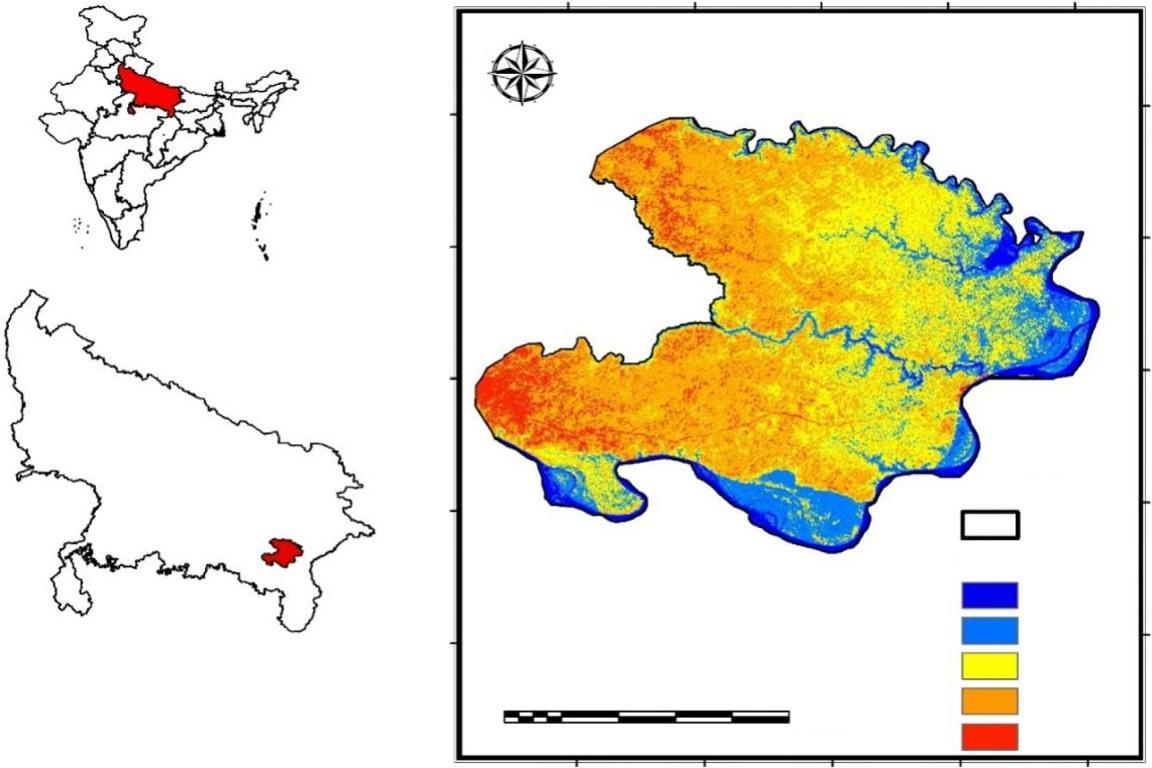
ThestudyareaislocatedinthecentralpartofIndo-GangeticplainoftheIndiansubcontinent.Varanasiistheoldestand religiousdistrictoftheUtterPradesh,India.VaranasihasbeentheculturalcenterofNorthIndiaforseveralthousandyears andiscloselylinkedtotheGanges.ItissituatedatthebankofGangaRiver.ThestudyarealiesinEasternUttarPradeshand boundedbetweentwomajorriverstheGangaRiverandGomatiRiver.TheRiverGangaliesinthesouthernandeasternpart ofthestudyareaandGomatiRiverliesinnorthernpart.Twosmalltributaries,namelyBasuhiandMorwalieinthewestern sideofthearea.TheVarunaRiverdividesthestudyareaintoalmosttwoequalparts.Thestudyareacoversthreedistricts; Varanasi,andsomeareasofSantRaviDasNagarandJaunpur.SantRaviDasNagarisalsoknownasBhadohi,situatedin theplainsoftheRiverGanga.JaunpurissituatedonthebankoftheGomatiRiver.
Thestudyareacoversabout2785km2 areainandaroundVaranasidistrict,ofwhich1535km2 locatedinVaranasi district.Thestudyarealiesbetweenthelatitude25
8230E8240E8250E830E8310E
STUDYAREA
Coordinate System: Lat Long WGS84
Datum: WGS84
Units: Degree
FIG.1 Locationofthestudyareawithobservationwellsandpumpingwells.
asshownin Fig.1.Theentireareaisdividedinto10administrativeblocksinwhich8blocksPindara,Cholapur,Baragaon, Harhua,Chiraigaon,Sevapuri,Arajiline,andKashiVidyaPeeth(KVP)existinVaranasiDistrict.
4.1Physiographyandtopographyofthearea
TheRiverGangaispresentasatrans-boundarybetweenIndiaandBangladesh,thepointoforiginofthe2525km(1569 mile)longRiverisWesternHimalayaintheIndianstateofUttarakhand,anditflowstothesouthandeastGangeticplains ofNorthIndiaintoBangladeshwhereitdrainsintheBayofBengal(GuptaandDeshpande,2004;Jainetal.,2007).Ganga isthelongestRiverofIndiaandisrankedsecondasthegreatestRiverintermsofwaterdischarge.Theaverageannual dischargeoftheRiverGangaisabout16,650m3/s( Jainetal.,2007).Gangabasinisofmagnificentvariationinaltitude, usageoftheland,thepatternofcrops,andclimate.OneofthetributariesofRiverGangaisGomatiRiverwhichoriginates fromtheGomattaal,Pilibhit,India.ThelengthoftheriverGomatiisaround900kmextendingfromthestateofUttar PradeshandmeetstheGanganearSaidpur,KaithiinGhazipur.OneoftheminortributariesoftheGangaisRiverVaruna. Throughouttheentirecourse,boththeriversreceivealargeamountofagriculturalrun-offconsistingofpesticidesand fertilizersfromthecatchmentarea.
Thetopographyofstudyareaischaracterizedbysignificantvariationintheelevation.Itvariesfrom33to101mmean sealevel(MSL).ThehighestelevationinthestudyareahasbeenobservedneararoundBhadohi.Theaverageelevationof theareais80.71mfrommeansealevel(MSL).TheGangaRiverhasanelevationof66.27mMSLatthepointwhereit entersintothestudyareaand60.78,whereitleavestheareainthedownstream.TheGomatiRiverelevationfromtopto bottomrangesfrom68.32to60.78mMSL,respectively.
Thegroundwaterflowmodelwasconceptualizedonthebasisofgeological,climatic,andhydro-geologicalcharacteristicsofthestudyarea.ParametershavebeenusedtodeveloptheFDMmodelaswell.Griddimensionhasbeentaken 100 100mforthedevelopmentofFDMmodel.Further,theAEM-PSOandFDM-PSOmodelswereappliedoncase 1andcase2tocomputethelocationanddischargeofunknownwells.
Initially5wellswereplacedatdifferentlocationsandcorrespondinggroundwaterheadswerecomputedbyAEMand headvalueswererecordedatpredefined12observationpoints.Theserecordedvalueswereconsideredasobservedvalues.
Further,theAEM-PSOandFDM-PSOmodelswereemployedtoidentifythelocationanddischargeofthosefivewellsby consideringdifferentsetsof1–5wells.Correspondingoptimalvaluesofobjectivefunctions,i.e.,REvaluesfordifferentset ofwellshavebeenrecordedandthenumberofwellswasfinalizedbasedonminimumvalueofRE.Theresultsof AEM-PSOandFDM-PSOmodelswereappliedontwocases(1)optimallocationanddischargeofwells,(2)Computational efficiencyofbothmodels.
Case1:
Inthiscase,optimaldischargeandlocationofpumpingwellswereidentifiedbystraightapplicationofAEM-PSOand FDM-PSOmodel.Efficiencyofmodelwascalculatedbyidentifyingthedifferenceindischargevaluesandlocationdisplacementbetweencomputedandobservedvalues.Locationdisplacementwascomputedbyaccumulatingthedifference betweenobservedandcomputedlocationofallwells,whichisdefinedas,
where, di isthedistancebetweentwoadjacentwellsand N ¼ totalnumberofwells.
ResultsindicatethatAEM-PSOhaserrorof1.9%–4.1%andFDMhaserrorof3.4%–7.3%indischargeratefor5wells. Whereas,AEM-PSOhaserrorof128mandFDMhaserrorof437.7minlocationdisplacementof5wells. Table1 shows thelocation,dischargerateofwellsandgroundwaterheadvaluesbybothAEM-PSOandFDM-PSOmodels.Results describethattheoptimallocationsdifferintheAEMandFDMmodel,whereAEMgivesmoreaccuratevaluesincomparisonofFDM.Althoughpresentmodelwasdevelopedbyconsideringsmallsizeofcells,butitshowsthatincreasingthe sizeofcellscanleadtomoreerrorinthefinalresults.
Maximumnumberofiterations,i.e.,1000wasconsideredfortheconvergenceoftheoptimizationmodel.Themodel convergenceshowedthattheAEM-PSOmodelconvergedafter905iterationsforthesetof5wells,whereastheFDM-PSO modelwasfoundtohaveconvergedafter825iterationsforthesetof5wells,respectively.Theresultsshowthatthe FDM-PSOmodelconvergedwithlessiterationthantheAEM-PSOmodel.TheparametersofthePSOmodelwereconsideredaslinearlyvaryinginertiaweightfrom2.0to1.8,accelerationconstant2.0–2.0.
Case2:
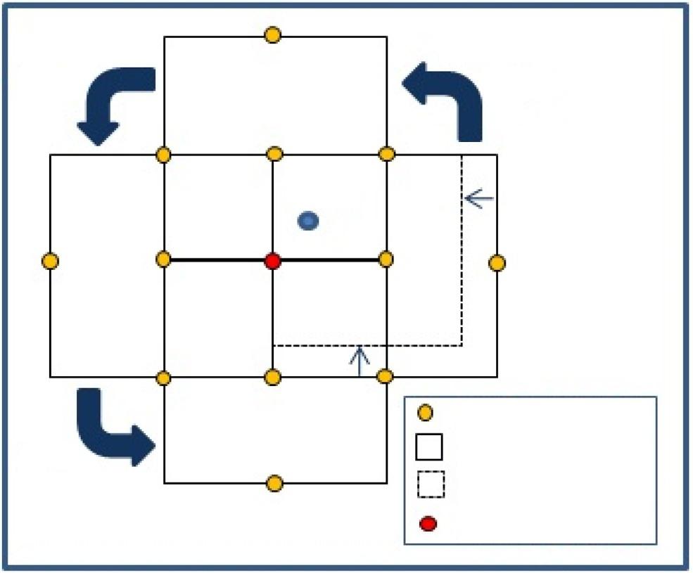
Inthiscase,movingsubdomainapproachwasappliedanditsefficiencyinbothAEMandFDMmodelwereanalyzed. Detaileddescriptionaboutthistechniquecanbefoundin AyvazandKarahan,2008.Inthisstudy,initiallocationofsubdomainwastakensameinAEMandFDMwithequalsizeof300m 300minAEMand3 3cellsinFDM.InAEM, domainsizewasallowedtoreducetill20m 20mfrom300m 300masAEMisnotboundedbyminimumsizeof grids.Predefinedwelllocationwasassumedonthecenterofthedomainandcenterofitssides.Contractionofdomain
TABLE1 Actualandoptimizedlocationanddischargeofthewellsincase1.
Case 1 Well ID
ExactlocationComputedlocationsRelativeerrorPumpingrates Xcoordinate Ycoordinates Xcoordinate Ycoordinates Location displacementExactComputed Relative errorRE
AEMW1687,2152,108,755687,1972,108,74321.631031662.22
W2686,5622,108,117686,5542,108,09820.628529510 W3687,1262,108,085687,1112,108,07319.23203299
W4686,0052,107,182685,9832,107,16031.129030212 W5686,8362,107,134686,8102,107,10936.12752816
FDMW1687,2152,108,755687,1432,108,69693.1310325153.48
W2686,5622,108,117686,5062,108,05186.628529813
W3687,1262,108,085687,0612,108,01397.032033111
W4686,0052,107,182685,9662,107,12073.229030212
W5686,8362,107,134686,7512,107,11287.827529520
wasallowedwhenthelocationofwellwasnotfoundimprovedinsubdomainbyflippinginalldirectionsasshownin Fig.2. Ineachcontractionofsubdomain,againitwasallowedtomoveinalldirectiontofindanyotherpossiblebestlocation.The procedureremainedcontinuetillthesubdomainsizeapproachestominimumlimit,i.e.,20 20m.Contractionwas employedtothetwosides,bytheshiftingrateof 10m,havingwellswithmoreREvaluesthanwellsofremaining twosides.TheREvalueforadditionofeachsubdomainwascomputedandusedtofindtheoptimalnumberofwells. Table2 showsnumberofwellsandthedifferentREvalues.WhereasreductionofsubdomainintheFDMmodelwas restrictedandthesubdomainwasallowedtomoveuntil,theoptimallocationwasnotfound.Optimallocationwasfinalized whenlocationofwell,inspecificcellofgrid,wasnotimproved.Tofinalizethelocationofcell,subdomainwasallowedto flipinalldirections(Fig.2).
Inthepresenceofoptimallocationofwell,locationoffinalcellwasnotfoundtobeimproved. Table3 showsthe location,dischargerateofwellsandgroundwaterheadvaluesbybothAEM-PSOandFDM-PSOmodelsforCase2.
Resultsshowthatoptimalnumberofwellsisfive,whichshowsminimumREvalues.Resultsindicatethatcumulative locationdisplacementinFDMwasfound270.7mmoreincomparisonoftheAEMmodel.Whereascomputedpumping rateswasfoundwiththeerrorof1.3%–2.1%inAEMand2.1%–3.6%inFDM.TotalnumberofiterationsinAEM-PSO modelwasfound22%moreincomparisonofFDMmodel.Itshowsthatsimulationmodelneedsmoreiterationtogetcloser valuestorealvalues.
ThecomparisonbetweenresultsofCase1andCase2shows(Table4)thatmovingsubdomainapproachisefficientto findmoreaccurateresults.Itwasalsoobservedthatlocationdisplacementerrorwasmoreimprovedthanpumpingrates errorinCase2.Itwasfoundthatlocationdisplacementerrorwasimprovedby42.7minAEMmodeland81.7minFDM modelfromCase1toCase2.Dischargevalueswereimprovedby1.1%inAEMand1.5%inFDM.InCase2,only5 decisionvariablesweretakentooptimizethepumpingrateofthewells,whereastotal15decisionvariablesweretaken inCase1tooptimizethelocationandpumpingrates.BothAEM-PSOandFDM-PSOmodelswereemployedforsingle runtofindtheoptimalsolutionintheCase1.WhereasinCase2,bothmodelstook10to15runstofindtheoptimalsolution. AlthoughmodelrunwasmoreinCase2,butduetopresenceoffivevariables,modelconvergesveryearlyincomparison ofCase1.
FIG.2 Flipandreductionofsubdomain.