
Department of Archaeology Durham University Academic Poster Exhibition
Elliott Lochhead, MA Archaeology student, pwfm28@durham.ac.uk


Introduction: The Roman Empire at its greatest extent stretched from Northern Britain, across to Mediterranean and all the way to Syria. This was all achieved through military successes continuing from the Roman Republic period until 117 AD, where ceased expanding and focused on maintaining their vast territory. To achieve both these aims they needed a well equipped army.
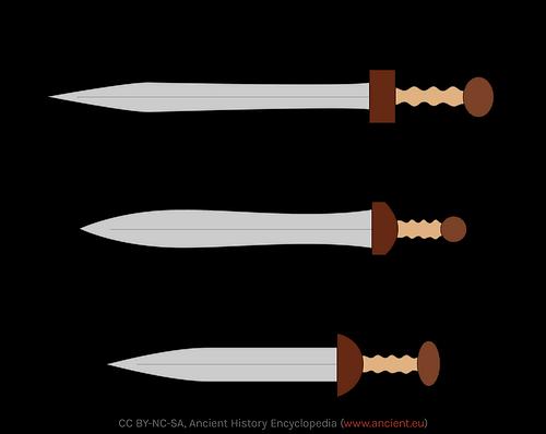
Arguably the most important legionary equipment was their sword (Gladius) Archaeological evidence suggests this remained quite consistent until around the 3rd Century AD (Sidebottom, 2004, pp. 87-88). In this poster we shall examine Roman blades, to ascertain what the development of Roman blades tell us about how they conducted warfare.
Mainz Gladius: Evolution of the design
• The Mainz Gladius is an evolution/continuation of the Hispaniensis, being made shorter and stouter compared to the older design. The blade itself measuring around 50-55cm. (Taylor, 2020, p. 9298). The similarity suggests military tactics did not change drastically from the adoption of the design.
• The name of the Mainz type is derived from the fact so many come from the Rhine at Mainz.
• The point of the blade was more triangular and longer than the Hispaniensis, making it better suited to stabbing. (Bishop and Coulston, p. 268). Further representative of the evolution, and refinement of existing military doctrine during the period.
Gladius Hispaniensis: The Republican blade
• Not originally a Roman design, they encountered it in Spain subsequently adopted it for themselves. (Bishop and Coulston, 2006, p. 54).
• The Suda a R a a a design but not the manufacturing process.
• A short sword intended for close combat, prioritising stabbing over slashing. Adoption marked change in military tactics to account for this. (Bishop and Coulston, p. 55).
• Intact blade excavated within its scabbard in 1987 at Delos. The blade itself measuring 63.1 cm, with a short triangular point. Dated to c. 69 BC. (Sanz, p. 260). Placing greater emphasis on thrusting attacks.
• Oldest examples recovered from Smihel in Slovenia, 2 swords likely being Gladius Hispaniensis, along with a hoard of other weapons. Dated between the 3rd and 2nd Century BC. (Horvat, 2002, p. 133, 143). Suggests long term use by Roman legions. Eventually replaced by the Mainz type gladius.


Gladius Pompeii: A notable change
• A new design emerged in the latter half of the first Century AD. The name of this design came from blades preserved by the eruption of Mount Vesuvius in 79 AD. (Taylor, p. 9298). Around four such blades recovered.
• This design saw the greatest level of use. Replaced the Mainz midway through the first Century AD. Why the change occurred is not clear, but coincided with other changes like to helmets. Possible like the Hispaniensis the Romans incorporated local designs after taking on recruits from new provinces. (Lang, 1988, p. 200). If true it demonstrates a pattern among the Romans of incorporating local designs into their equipment.
• The blade measured around 45-50 cm. The shortest of the Gladius blades. Its popular use and manufacture may in part have been influenced by its size, requiring less material to make. Making it easier to equip a growing army.


• Had parallel cutting edges and a pointed tip. Putting some more emphasis on slashing movements, indicating a move toward greater versatility in Roman military tactics. Though historians like Polybius did a P cutting. (Bishop and Coulston, p. 79).
The Spatha: blades from the 3rd century onwards
• By the 3rd Century the Gladius blades were replaced by the Spatha for all types of troops (Bishop and Coulston, p. 154). A blade that was traditionally used by cavalry units.
• A longer blade compared to its Gladius predecessors, though less uniform in design. Ranging from 62 to 91cm. (Davies, 2012, p. 697). A far greater emphasis is placed on slashing over stabbing.
• Indicates a significant change in Roman military doctrine. The traditional close quarters being replaced by more open style melee combat. (Davies, p. 697). It may also have been influenced by a greater use of cavalry by the Roman army. (Lang, p. 200).
• Evidence suggests by the 3rd Century there was little differentiation between Legionary and Auxiliary units, the adoption of the Spatha reflecting this, their fighting styles merging into one. (Bishop and Coulston, p. 259).
• Spatha have been found at various sites, some abandoned by the 3rd Century, like 6 at Dura and other frontier provinces like Britain, where around 8 have been found.
Conclusions:
• The blades reflected the strategies adopted by Roman legions, the similarity between Gladius blades indicating a refinement and evolution of closequarter combat until the 3rd Century, where the widespread use of the Spatha indicates a significant change toward open melee combat.
• The Romans were willing to adopt new designs from outside sources if they deemed it suitable to their strategies, as seen with the Hispaniensis and potentially the Pompeii Gladius
• Economic considerations and changes in recruitment may also have influenced the designs adopted, such as the increasingly shortened Gladius, or lack of uniformity with the Spatha
Between the years 117 AD and 138AD, the Emperor Hadrian and his Imperial administrators saw feeding Rome and its swelling population as a priority. To secure this Pax et Panem, the Roman state needed to ensure that grain and olive oil came into the city. To interrupt this trade would be politically disastrous for the Emperor, and potentially cause starvation to untold millions in Italy and abroad. This required a handson approach from the Imperial household, they intended to squeeze the province of Africa Proconsularis dry.
Hadrian, in his wisdom, saw to remedy this issue through legislation to try and increase the productivity of estates within the Empire. One manifestation of this policy was the lex Hadriana de rudibus agris "the law of Hadrian concerning vacant lands". This law, has been handed down to us through two inscriptions. The oldest, from the time of Hadrian itself, survived and was found within Ain - el- Djemala, in the Medjerda valley of Northern Tunisia. The law also survives in form from a similar inscription from the time of Septimius Severus, giving the law a lifetime of potentially 94 years. (117 - 211AD)
" because our Caesar [in keeping with] his tireless care, because of which he is assiduously vigilant for the interests of humankind, orders all parts of the fields that are suited for both Olives or Vines as well as cereals to be brought under cultivation ; therefore, by the permission of his providence the authority accrues to everyone to occupy even those parts which are in the leased out centuries of the estate of Blandus and Udens (landowners) and in those parts which have been joined to the Tuzritan estate from the Lamian and Domitian estate, and are not being worked by the lessees; to who have occupied them that right of possession and enjoyment"
(translation of Face 2 of the Ain- el- Djemala Kehoe 1988)

If we are to investigate how effective the Hadrianic push for the exploitation of vacant land was, we need to consult several avenues of investigation:
1. We need to identify changes in the amount of land used and settled throughout the long durée


2. We need to identify what would denote an increase in usage of disused land/ untouched agricultural land.
3. What can be drawn/ interpreted about the Lex Hadriana from the data presented to us from landscape surveys.

Can we identify an increase in activity from the preHadrianic and into the Hadrianic period of the Medjerda valley?
The Thugga survey of the Bagradas region used fieldwalking and standing building surveys to build a complete picture of the entire agricultural economy of the Bagradas region of the Medjerda valley from Punic history until the Islamic invasion. The data collected from this survey proves invaluable in mapping and distinguishing growth and decay within the agricultural economy of North Africa in the Hadrianic period.
So, what does this mean?....Interpreting the results of the Thugga survey.
Margriette De Vos' Thugga Survey, of the Bagradas region, found that between the Early Roman (100BC-117AD), and the Middle Roman Period (117AD -306AD) (Hadrian to Constantine), there was only an increase of 19 Hadrianic and post-Hadrianic sites. This is low, compared to later growth, as seen in the Vandal and Byzantine period. This fall in growth rate could have been the prompt for Hadrians edict.
From this data we can build a picture of the environment which the Lex Hadriana was made in and gain insight into the type of growth the Romans were looking for in their North African holdings.
We see a 20% drop in the number of "New" between the Early Roman and the Middle Roman. This would have alarmed the Roman administration over a long period of time, and thus legislation was required to stop this drop.
The Lex Hadriana we can infer was in response to this drop in sites. We see that In the Roman view, more sites would have led to more production. The objective was to produce more sites. By making it law that freeholders could take up more land that lay vacant, they sought to increase the number of sites. This led to an increase in the growth of the total number of sites, as more land was occupied.
The data from the Thugga survey is conflicting. There clearly was an "action and reaction" in the growth of settlement due to the Lex Hadriana. However, the lack of 2nd century coinage paints a sorry picture of the economy of the time.
In hindsight, when looking at the heights the economy grew to in the Vandal and Byzantine period (with 126 and 121 total sites each), we can say that the Lex Hadriana failed to facilitate the full potential of the Medjerda valley in Antiquity. However, when looking at the data Infront of us, we can piece together a picture of a struggling economy, with a lack of growth, that picked up after a successful redistribution of land and opening of the economy to new farmsteads and settlement.
The excavation of Alto Tell supplemented the Thugga survey. From which they found that there was a distinct lack of coinage and activity from the 2nd Century AD, with economic activity picking up only in the 4th to 6th Century. Denoting a lack of monetised commercial activity in the settlement at the time.
Whether or not this led to an increase in production however remains to be seen...
By Tom Millin - lrfw39@durham.ac.ukTo fully elucidate the economic situation of the Medjerda Valley, further investigation is required to determine whether this increase in settlement growth led to an increase in productivity and improved the number of goods coming from the province. To explore this, there must be further work done to determine the overall shape of the economy of the region after the Lex Hadriana
Face 2 of the Ain -el -Djemala inscription. Hadrianic, 117AD -138ADDepartment of Archaeology, Durham University Siyuan Liu - Siyuan.Liu@durham.ac.uk

Background: Phoenicia and Coele Syria were a point of contest between the Seleucids and the Ptolemies during the series of Syrian Wars. It was subdued by the Ptolemies after 294 BC, and eventually fell into Seleucid’s control after Antiochus III’s victory at the Battle of Panion. Seleucid kings would have wanted to counter the pre-existing Ptolemaic influence on these land.

This distinctive iconography, numismaticians referred as ‘Phoenician Eagle’ persisted on silver coins that were minted in this district from Antiochus V’s reign onward.


Why should it not has existed?
A. It was not in accordance with the imperial standard reverse image of the Seleucid kingdom, Apollo on Omphalos type,(Figure3) but it was in approximation to the standard reverse image of Ptolemy kingdom.(Figure 4) Except on Ptolemaic coins, eagle stands on a thunderbolt. On Seleucid coins, eagle stands on a palm branch.
B. Seleucid coinage customarily followed the Attica weight standard, whereas all Phoenician coins followed its own weight standard.(Table 1)
C. Imperial standard coins were minted and circulated in Phoenicia in interim. d. Despite the emergence of new imperial images due to usurpations and internal political squabbles, this image persisted in this area.


Consciously designed, embodied dynastical legitimacy, unity of Greekness and Mesopotamian traits. Replaced in Phoenicia by eagle images.
‘I therefore now confirm to you all the remissions of tribute conceded to you by the kings before me, … I grant you the right to strike coins with your own types to be legal tender in your country.’
I Maccabee 15. 2-3
Caption 1, Antiochus VII’s letter to Simon, high priest of Isreal
Number of mints in Phoenicia/total mints
Seleucus IV 5/13
Antiochus IV 11/31
Antiochus V 5/10
Demetrius I 6/15
Alexander Balas 11/21
Demetrius II 7/17
Antiochus VI 5/9
Antiochus VII 8/18
Clause 8, ‘He shall surrender his ships of war(to Rome), their tackle and fittings, and in future shall not have more than ten undecked vessels, Clause 9, ‘he shall not sail to this side of the river Claycadnus (note: west of Cyprus) except for the purpose of brining tribute, ambassadors or hostages’

Caption 2
Why might it have been an issue?
See dotted circles. They were clothed with chlamys according to Ptolemaic mintage tradition.(Figure 4) Seleucid kings were bare necked on their coins.(Figure 3)
Polybius 21 43
Table 2
Control mark, palm branch, distinctively Phoenician.


Precious metal coins often carried more political ceremonial significance, or ‘sight power’, visible representation of kingship that was accessible in daily life.(Hekster, 2005, 160-161) Tetradrachm was especially the case, as it made up the most currency among all denominations. ( Aperghis, 2001, 93) Images on silver coins were better preserved, as these large denominations were not used in daily exchange, but for issuing wages, paying tax. Indeed, the imperial Apollo image was mint in Phoenicia until Antiochus V, thus it could not have been in the interest of Seleucid kings to mint Phoenician Eagle type.
a. Right to mint and operate own coinage was equivalent to formal concession on the king’s part to grant autonomy. (Caption 1)
b. It undoubtedly carried residual Ptolemaic memory.
c. Number of mints in this area bore overweighting ratio comparing total number of mints in operation, (Table 2) thus this image would have practically became a main image in circulation, which overbore Apollo on Omphalos.
d. Difficult to participate in domestic economic exchange due to unique weight standard.
Two potentialities could have been the case. Both suggest Phoenicia enjoyed growing leniency toward their economic autonomy.
1. Phoenicia was indeed granted a degree of autonomy. The treaty of Apamea(188BC) crippled the Seleucid navial power.(Caption 2) Meanwhile, Phoenicia maintained strong maritime existence that was exempted from this treaty. It was a strong reason for the Seleucid kings to appease to the Phoenicians’ affection, to sustained their naval autonomy, sailing their ships under the Phoenician flag rather than the Seleucid flag due to the Roman maritime ban. Note that all mints in Phoenicia operated on port sites.(Figure 1) As Seleucid lost more territories in Mesopotamia and Anatolia, it naturally grew more economically attached to Phoenicia in the later period, to the extent of granting them leniency in their autonomy.
2. Scholars such as Iossif and Chrubasik suggested that Phoenician eagle was not an expression of civic character. It does not embody an iconic local deity or persona that was intended to counter the presiding Greeco-Babylonian ideology & ruler cult, such as in Cilicia or Judea. Hence it could simply be in Phoenician’s financial interest to facilitate the market with the pre-existed dominating currency. Due to the economical their dependency to Phoenicia, subsequent kings did not challenge this practice.


Transfer of Trade Domination in South Iran: analysis based on distribution of Chinese ceramics

Figure 1 illustrates the variation in Chinese ceramics trade in different regions of South Iran. During the Tang dynasty, Siraf was the most important region for importing Chinese ceramics, while its role began changing in the Song dynasty. Until the end of the Ming dynasty, it was no longer one of the ports that imported Chinese ceramics. There was a transient development of trade in Kish during the Yuan Dynasty, however, the development gradually faded in the next dynasty. In contrast, the Chinese ceramics trade in Hormoz started in the Yuan Dynasty and reached its peak in the Ming Dynasty. Minab has played an important role in Chinese ceramics trading for centuries, beginning with the Song Dynasty. And this region remained the dominant area for Chinese ceramics imports. Hence, the trade domination went southwards.


Balli be Ca le i C
R c mm I ela d i a
medie al kee le ca le I i
e f he a di g A gl

N ma ca le i he c
a d i h gh ha e bee
b il i he h ce I i
c e l bei g e ca a ed a
a f a field ch l jec


I ela d A chae l g Ca le i
C mm i ie hich bega i
The ca le i ell
de d a chae l gicall
Wha i k i ha i i a
e e e a i f a im a
m me i hi he ggle
a d i e ac i be ee he
A gl N ma a d he I i h
C e a chae l gical e ea ch ha f c ed
c i g i ide f he ca le ece l mai l C i g
f he igi al ca le e a ce Thi c i g aim de a d h he ca le e a ce a b il a d ha if a cha ge cc ed h gh i hi
The e a ce i i a f ified ga e a i h i e me e ac The i i i g f he c i g a i f med b ge h ical e G d Pe e a i g Rada e f med e i l
Image h C i g a i a a he e d f he m ece field ea
E ide ce f he e a ce i clea he

l ki g a he c i g he image S e la he edge f he alk a a d he e i he middle i dica e a c lla e f me f c e The e a e al la ge
e ha ld ha e bee he
f da i f he ga e I e e i gl he e e ac all c e ed d i g a la e ha e f c c i Thi c e i g i al e ide i he alk a la e i h he medie al c bble bei g c e ed i h a ghe j mbled e la e
Refe e ce
All i f ma i ake f m he I ela d
A chae l g Ca le i C mm i ie Si e
h i e g gle c m ie i ela dca le i c mm i ie h me
Image U c e ed Medie al Age C bble Sam el C el F hill C llege Image Balli be Ca le Da iel Cea le La P i a C llege Image C i g Sam el C el Image A i I e e a i f he Ca le E a ce R c mm C cil
This poster outlines and analyses the bone assemblage at the rural Roman settlement situated on Yapham road, Pocklington, southeast Yorkshire, to assess whether the site is consistent with contemporaneous Romano-British zooarchaeological assemblages.
MNI calculations indicate that there were also 2 dog s and 2 horses, likely kept as pets or as workhorses, as well as 1 deer, 1 fish, and 1 small bird, likely from hunting in the local landscape or imported from a nearby market Suffice to say, these animals were not reared and kept in the same capacity as cattle or sheep, and, to a lesser extent, pigs .
• The dearth of pigs at this site is in keeping with other rural Romano-British sites Pigs are much more common at urban sites or highly Romanized villas, where the high pork diet of Rome was practiced [3, 4].
• Pigs only yield meat, which makes them a risky investment for those living closer to subsistence levels, who require multifaceted livestock for clothing, traction, and food
• Evidence of dog gnawing on fused bones indicates that the bones were butchered and the meat stripped prior to being given to the dog


• The bones were sorted by element, species, bone fusion, relative joints and sides, fragmentation, modification like butchery, dog gnawing, or acid root etching and preservation [1]
• NISP- The Number of Identified Specimens Present was calculated to assess the number of bones from each species present in the assemblage [2].


• MNI- The Minimum Number of Individuals was calculated to determine the smallest number of individuals that could possibly be present in the assemblage [2]
Cow
Percentage of species by MNI


• As is common across most rural Romano-British sites, sheep, alongside cattle, are the most ubiquitous in zooarchaeological assemblages [5, 8, 9].
• There is more evidence of butchery on unfused, or juvenile, bones than on fused, which suggests that lamb was preferred over mutton.
• Purposeful slaughter of juveniles might suggest dairying, which was more common than cattle dairying in northern Romano-Britain [4].
• An older flock also suggests that sheep were utilized for wool to make clothing, which was very common across Romano-Britain [6].

• Furthermore, Pocklington lies on the eastern side of the Yorkshire Wolds, which indicates that the upland area may have been utilized as pasture.
• Whilst sex was not determined during bone analysis, the low number of juveniles suggests that cattle were not used for dairy, which is often indicated by high calf mortality [4].

• As shown by the high number of butchery marks found on fused bones, cattle at this site were largely slaughtered once mature. This suggests that aside from meat, cattle were used for traction, manure and their hide [4, 5].
• This is characteristic of other rural Romano-British cattle herds with various purposes [ 3 , 6].
• Furthermore, Pockling on proximity to Eboracum (York) suggests that cattle at this site may have been acquired from, or sold into, the cattle trade running through Britain and even mainland Europe [7]
We can see that the economy revolved around cattle and sheep This may be due to Pockling on proximity to the Yorkshire Wolds and its suitable pastureland Furthermore, the site may have engaged in the cattle trade running from Eboracum to the rest of the Roman world. Pigs are present, so may have been consumed at special feasts or by visiting elites. Ultimately, this is a typical rural Romano-British site.


The evidence for the existence of the earthquake in this region is supported by the historical evidence, as well as later archeoseismology investigations (right); the resulting earthquake dealt damage in an area covering the entire region surrounding the Kairouan city area – badly damaging 13 settlements, including Dibsi Faraj.


Dibsi Faraj was a Roman, Byzantine and Islamic fortification on the border of the Euphrates in modern-day Syria. The site was originally constructed in the Diocletianic period, near the end of the third century, and covered a five-hectare area; after that, there were a series of four major construction phases, before the site was abandoned in the 9th century. The original excavations of the site took place between 1972 and 1974 and were funded by Dunbarton Oaks; three papers were released from these excavations, detailing the phases of urban planning and theorising that the abandonment of the site between the 9th and 12th centuries came after an earthquake in 859AD.
While it is reasonable to assume people may have left the fort after the earthquake, many of the towns and villages that were damaged by the earthquake were ultimately re-settled after the incident, and so more proof is needed to present the argument that this site was truly abandoned. The best supporting evidence is the latest known construction phases, which took place on the Umayyad L-shaped building.
This construction (above) built during the Islamic period of occupation is unknown in function, due to the commonality of Lshaped buildings in the 7th century; the only clue as to its purpose is the fact it was built on top of the old basilica (above), suggesting it may have been a religious building. Built over these foundations was a square-shaped building that Harper dates to anywhere up the 12th century; this building is also built up over the south wall, disputing the idea that the damage – presumably done by the earthquake – was repaired. Therefore, the L-Shaped building’s unique style and the later square building over it give a time frame for its abandonment that fits with the 859 AD earthquake.


The Nebra Sky Disc has gold leaf embossed symbols decorated across its surface and is linked to the central German Únětice culture Meller 2021 It was found through the illegal excavations of treasure hunters in 1999 as part of a hoard of bronze artefacts and was only seized after 4 years of trading Gebhard Krause 2020a Pernicka et al 2003 It has been dated to 1600 BC based on the accompanying artefacts establishing it as the earliest astronomically identifiable representation of the night sky Pernicka et al 2003 p 8


The lack of substantial excavation data has meant that there has been a reliance on the contradictory allegations of the finders regarding the site location and contents of the hoard Since the disc cannot be easily independently dated the dating of the disc is solely anchored on its association with the hoard Some scholars argue that the disc should be separated from this hoard and instead it should be investigated as a single find due to its obscure origins On this basis some scholars argue that the disc does not follow the pictorial traditions of the Early and Middle Bronze Age Instead they suggest that it best fits the Iron Age iconography Gebhard Krause 2020b
Da e 1600 BC the end of the Early European Bronze Age

L ca Mittelberg hill near Nebra Saxony Anhalt central Germany
The manufacture of the disc was not limited to the local area instead the technology to produce gold inlays came from Mycenae Greece The copper component of the bronze that was used originated from a prehistoric copper mine at Mitterberg Austria Whereas the gold was more likely sourced from the Carpathian basin Romania The disc s manufacture illustrates the combined European Bronze Age undertaking for its creation Pernicka et al 2003 c m
The disc has been altered in 5 phases of development during its period of use

The disc has 32 small circles a circle and crescent shape
Two opposing horizontal arcs are added at the edges a star is shifted to accommodate the addition two stars are covered by an arc 30 stars are visible
A gold inlayed arc is added at the bottom 38 40 pinholes are added along its rim
The left horizon arc was removed Meller 2021
The a g d a d c c e represent stars however there is debate as to whether they accurately correspond to the constellations or whether they are purely symbolic Mozel 2003

The a ge c c e is interpreted as either a sun or a full moon or both The g a c are regarded as the horizons east and west
The c e ce ha ed b is regarded as a waxing moon while the b a c is interpreted as a boat carrying the moon or sun which is reinforced by similar representations on Bronze Age artefacts of the journey of the sun by ship However there are alternative arguments that it s a rainbow or the Milky Way Meller 2021

F c
The disc possibly had a ceremonial calendrical or astronomical function or was multi functional over its history this is reinforced by the multiple alterations as it suggests that the disc was changed in line with its changing meaning and purpose Mozel 2003
There is evidence of a ca e d ca a d a ca function starting from the disc s creation the first phase as a lunisolar calendar precise enough to pinpoint the time for the first time based on the position of the Pleiades cluster of 7 stars compared to the crescent moon
When March s 4 5 day old crescent moon fit the shape indicated on the disc was near the Pleiades and 32 days 32 stars had elapsed since the last first crescent moon a leap month was added to synchronize the lunar and solar year Meller 2021
The opposing horizontal arches 2nd phase symbolize the area of the sunrise and sunset on the horizon and the sun s journey between the summer and winter solstice On the summer solstice the sun rises at point A and sets at point B whereas on the winter solstice the sun rises at point C and sets at the D fig 5 The arches are slightly asymmetric to indicate the north south orientation
It has been suggested that the pinholes 4th phase were to attach it to fabric wood or a frame for display in ceremonies In the centuries following the disc s creation the depiction of the sun carried by ship became a central Nordic Bronze Age religious concept Meller 2021


The multiple stages of alterations the disc was subjected to support the idea that it served different purposes during its history Despite the controversy surrounding its discovery and dating it demonstrates a particularly thorough understanding of astronomical knowledge and is possibly the oldest representation of the sky that is not just artistic
Math ra is regarded as the centre of the creation and de elopment of art and iconograph of three major sects of ancient India Hind ism, B ddhism, and Jainism. E en tho gh there are indications of image orship in the region, the lack of archaeological remains s ggests that it as either not er prominent or the images ere made sing perishable material s ch as ood (G pta, 9, 56). This absence of stone iconograph led archaeologists like Fo cher (1917) to arg e that B ddha imager had Greek origins.
The Ma thra st le B ddha and Gandhara st le B ddha is dated almost to the same era hich led to polarising ie points among scholars. Some belie e that there as no iconograph of B ddha before the reign of Kanishka (78 CE - 1 4 CE) and others belie e that it as de eloped d ring the Saka Ksatrapa period (1 BCE) (G pta, 9, 57 ).
The earliest e idence of the representation of B ddha in Math ra art is in aniconic form (Rhi, 1994, 1 ) These s mbols incl de (Fig 1 ): The Bodhi tree, The footprints of B ddha, The Begging Bo l, The Wheel, The St pa, The T rban, The riderless horse, Ma ade i in her dreams ith an elephant, Ma ade i nder the Sarla tree, and Lions (G pta, 9, 58).


While Fo cher (1917, 111-1 9) attested that the inferior art of India mimicked the Greekinfl enced image of B ddha the contin it and grad al de elopment of the iconograph of B ddha reflects other ise. Sir John Marshall, stated that stone replaced ood in Math ra art b 1 BCE hich is abo t the same time pre-Kanishka B ddha emerges. Chinese records mention General Hoki ping seeing a golden B ddha in India and bringing it to the emperor in 1 1 BCE (G pta, 9, 57 ). Both Art Schools impacted each other and the pre alence of the debate and acceptance of Gandhara as the origin of the B ddha image can be seen as a res lt of E rocentrism and the acceptance of Math ra ' s origin of nationalism.


Under the reign of Kanishka (78 AD), the images of B ddha de eloped in t o forms: The standing and The seated B ddha (Fig 4). The dates of the images ere inscribed (Rhi, 1994, 1 ). The second phase of the Kh shan period is attrib ted to the introd ction of the Gandhara infl ence like the isible folds in the draper and the c rls in the hair (G pta, 9,6 -65)
Anal sing the trends in the de elopment of the image of B ddha in Math ra it is clear that it as impacted b political and social de elopments With the increase in patronage, art flo rished and transformed as per patrons' req ests. The q estion of its origin might not be archaeologicall pro en b t the contrib tion and importance of the B ddhist art of Math ra in the c lt ral realm co ld be pro ed. Math ra remains an important cit since 4 BCE till toda and it o es m ch of it to the Golden Age of its art nder B ddhist patronage
These images are dated b R.C. Sharma (Sharma, 1984, 17 ) back to the Saka Ksatrapa period (1 BCE). This imager of B ddha is e tremel similar to the Yaksha (fertilit God) image (Fig .) and the Jaina A agapattas. The images are car ed on pillars, and Torana (gate a ) and mimic the Katra B ddha of the later period ( G pta, 9, 6 )
Altho gh the prod ction as not as high as it as nder the Kh shans the nder G pta's Math ra art pinnacle (Fig 5.). The image shifted to ard a more delicate and sophisticated depiction of B ddha B ddhist art de eloped a narrati e st le sho casing the life of B ddha. B ddhist art ho e er declined ith G pta ith the decline of B ddhism in the s bcontinent (G pta, 9, 68-7 ).


Stonehenge is one of the most famous prehistoric monuments in the world. The megalithic circle has fascinated many people in the past, but its appeal is not only because of its structure, but also the fact that, like many other prehistoric earth and stone monuments, it is thought to have been built with astronomical phenomena in mind. So what are these astronomical phenomena?
Stonehenge is situated on Salisbury Plain (Wiltshire, in southern England), which contains one of the densest concentrations of Neolithic and Early Bronze Age monuments in Northern Europe.
Stonehenge has 5 constructional stages.
Stage 1: The Late Neolithic (c 2900 BC) (Figure 3)
The circular enclosure has a single ring of bluestones in the Aubrey Holes and timber post arrangements in the interior.
Stage 2: The end of the Late Neolithic (c 2500 BC) (Figure 4)


The stones are placed in the centre of the interior.
Stage 3: The Copper Age (c 2400) (Figure 5)
The avenue is built, and minor changes are made to the stone arrangement.
Stage 4: The Early Bronze Age (c 2100 BC) (Figure 6)
Within the sarsen circle, the bluestones are rearranged.
Stage 5: The Middle Bronze Age (c 1600 BC) (Figure 7) Around the sarsen circle, Y and Z holes are dug, and over 100 axe carvings are made on several of the stones.
The timing of the Great Standing Moon is different from that of the Midsummer Solstice during the rest of the year. However, the most dramatic moon risings in the Great Standing are when the midsummer full moon and moonset coincide, and the midsummer full moon and the northern Great Standing in midwinter.
The theory that Stonehenge was a prehistoric calendar or observatory for predicting solar and lunar eclipses has been made since the 1960s.
The Neolithic and Early Bronze Age landscape at Stonehenge (Figure 1) includes Early Neolithic causewayed enclosures (Larkhill and Robin Hood's Ball), long barrows (black oblongs such as Winterbourne Stoke Crossroads), Middle Neolithic cursuses, Late Neolithic Stonehenge, Coneybury, Bluestonehenge, Durrington Walls (one of the largest henge monuments), Woodhenge and Early Bronze Age round barrows (black circles).


Stonehenge was built in five phases over a period of more than a thousand years, from the Middle Neolithic to the Middle Bronze Age, 30001600 BC. It was in Phase 2 that it took the form almost exactly as we see it today, with a megalithic circle built with five sarsen trilithons (pairs of upright stones with lintels) at its centre


The rising and setting poles of the sun and moon are the most visible astronomical phenomena at Stonehenge. On the longest day of the year, 21-22 June, the sun reaches its most northerly point, rising (north-east) and setting (north-west) The summer solstice occurs when the sun makes the longest arc across the sky It has the shortest arc, rising in the southeast and setting in the south-west on the 21st of December, the mid-winter winter solstice
The movement of the moon is more complex. Like the sun, it regularly reaches a lunar rising and setting polarity (minor lunar standstills), but only once every 18.6 years does it reach a true lunar rising and setting polarity (major lunar standstills). Major moonrise in the Northern Hemisphere is 4° north of summer solstice sunrise, while major moonrise in the Southern Hemisphere is 6° south of winter solstice sunrise. The relationship between major moon rises and summer solstice sunsets is similar.

The astronomical phenomena on the summer and winter solstices are particularly clear and many people visit Stonehenge every year. The prehistoric structure still fascinates people and has an important role as a human heritage linking our ancestors to us in the present day.
Darvill, T., Marshall, P., Pearson, M. P., & Wainwright, G. (2012). Stonehenge remodelled. Antiquity, 86 (334), 1021+. https://link.gale.com/apps/doc/A313795415/AONE?u=duruni&sid=bookmark-AONE&xid=16b0eec8
Parker Pearson, M. (2013). Researching Stonehenge: Theories Past and Present. Archaeology International, 16, 72–83. https://doi.org/10.5334/ai.1601
Darvill, T., M. P., Wainwright, (2012). Stonehenge remodelled. (334), Pearson, M. (2013). Theories Archaeology 16, 72–83. https://doi.org/10.5334/ai.1601
Parker Pearson, M. (2019). Stonehenge for the ancestors. Part 1, Landscape and monuments. Sidestone Press.
Pearson, M., Marshall, P., Pollard, J., Richards, C., Welham, K., & Thomas, J. (2013). Stonehenge. In The Oxford Handbook of the European Bronze Age. Oxford University Press. https://doi.org/10.1093/oxfordhb/9780199572861.013.0009
Parker Pearson, M., Marshall, P., Pollard, J., Richards, C., Welham, K., & Thomas, J. (2013). Stonehenge. In The Oxford Handbook of the European Bronze Age. Oxford University Press. https://doi.org/10.1093/oxfordhb/9780199572861.013.0009
Parker Pearson, M., Pollard, J., Richards, C., Thomas, J., Tirrey, C., & Welham, K. (2019). Stonehenge for the ancestors. Part 1, Landscape and monuments. Sidestone Press.

Souden, D. (1997). Stonehenge : mysteries of the stones and landscape. Collins & Brown.
Parker Pearson, M., Richards, C., Pollard, J., Thomas, J., Welham, K., Dunn, P., Stanford, A., & Luis, I. de. (2015). Stonehenge : making sense of a prehistoric mystery. Council for British Archaeology. Souden, D. (1997). Stonehenge : mysteries of the stones and landscape. Collins & Brown.

 Figure 9: Winter solstice on the 22nd of December 2022 (© Tomoko Okuda)
Figure 8: Direction of the solstice (sun) and standstill (moon) as seen on the horizon by an observer in southern England (Parker Pearson et al., 2015)
Figure 4: The end of the Late Neolithic (c 2500 BC) (Parker Pearson et al., 2015)
Stage 1 Stage 3
Stage 4 Stage 5
Figure 3: The Late Neolithic (c 2900 BC) (Parker Pearson et al., 2015)
Stage 2
Figure 1: The Neolithic and Early Bronze Age landscape at Stonehenge (Parker Pearson et al., 2019)
Figure 2: Stonehenge (© Tomoko Okuda)
Figure 5: The Copper Age (c 2400) (Parker Pearson et al., 2015)
Figure 6: The Early Bronze Age (c 2100 BC) (Parker Pearson et al., 2015)
Figure 7: The Middle Bronze Age (c 1600 BC) (Parker Pearson et al., 2015)
Tomoko Okuda MA Archaeology
Figure 9: Winter solstice on the 22nd of December 2022 (© Tomoko Okuda)
Figure 8: Direction of the solstice (sun) and standstill (moon) as seen on the horizon by an observer in southern England (Parker Pearson et al., 2015)
Figure 4: The end of the Late Neolithic (c 2500 BC) (Parker Pearson et al., 2015)
Stage 1 Stage 3
Stage 4 Stage 5
Figure 3: The Late Neolithic (c 2900 BC) (Parker Pearson et al., 2015)
Stage 2
Figure 1: The Neolithic and Early Bronze Age landscape at Stonehenge (Parker Pearson et al., 2019)
Figure 2: Stonehenge (© Tomoko Okuda)
Figure 5: The Copper Age (c 2400) (Parker Pearson et al., 2015)
Figure 6: The Early Bronze Age (c 2100 BC) (Parker Pearson et al., 2015)
Figure 7: The Middle Bronze Age (c 1600 BC) (Parker Pearson et al., 2015)
Tomoko Okuda MA Archaeology
The Black Desert covers north-east Jordan, south Syria, and north Saudi Arabia (Brusgaard, 2019:2)(fig 1) and is an arid limestone plateau overlaid by basalt boulders with occasional mudflats and temporary lakes caused by runoff water (Huigens, 2019:19-21). Between the 1st century BCE – 4th century CE, the Black Desert was inhabited by nomadic pastoralists, grazing sheep, goats, cattle and camels (Huigens, 2019:6) The region is ideal for studying ancient nomadism due to features such as rock art, inscriptions and paths, and an arid environment which helps to preserve archaeology Ethnographic studies of modern nomadic Bedouin tribes in the region can also inform research into ancient migration patterns (Meister, et al , 2019)


As movement is intangible, past mobility must be studied through its ‘materialized’ aspects (Aldred, 2014:26) such as features created to culturally mark the landscape (ibid.:33) Archaeology usually focuses on sedentism (Aldred, 2014) However, Sheller & Urry (2006) developed a ‘new mobilities paradigm’ which has influenced the social sciences and led to an increasing number of archaeological and anthropological studies focusing on mobility and movement (Barnard & Wendrich, 2008; Snead, et al , 2010; Beaudry & Parno 2013; Leary 2014; Aldred, 2021)
Nomadism is by definition transient and was traditionally thought to be invisible in the archaeological record (Childe, 1936:91; Finkelstein & Perevolotsky, 1990) with literary sources from sedentary societies often used to study ancient nomadic peoples (Leiden University, n d ) However, ethnoarchaeology (Meister, et al , 2019), fieldwalking with a siteless methodology (Gallant, 1986:409) and remote sensing (Silver, et al., 2019) can be used to identify and interpret ancient nomadism from a non-sedentary perspective
Carved into the basalt boulders of the Black Desert by nomadic tribes are thousands of rock art depictions of animals, human figures and complex scenes (Brusgaard, 2019:3). The petroglyphs can be dated to the 1st century BCE – 4th century CE by their artistic style, the patina on carved basalt (which turns from grey to orange over time) and by association with Safaitic inscriptions (ibid.:27)


Camels make up 33% of all figures in the study area (ibid.:50)(fig 2 & 3), reflecting their importance to long distance mobility between 1st century BCE and 4th century CE and potentially indicating an ‘elevated socio-ideological position’ in nomadic life (ibid.:168)

Prehistoric desert kites (fig 4) are also depicted (fig 5) Thought to have been structures built to herd wild animals into an enclosure, they significantly pre-date the petroglyphs but were potentially still used as a hunting strategy by nomadic pastoralists (ibid 20-21)

Figure 5 shows how the artist incorporated the natural shape of the rock into the topographical representation (ibid.:88).
Petroglyphs are clustered at inaccessible vantage points (ibid.:175), suggesting that carvings were added to over time, becoming cultural markers and ‘historical narratives of the landscape’ (ibid.:179)


There are also thousands of Safaitic inscriptions in the Black Desert


The difficulty and noise of carving basalt suggests the inscriptions were intentional and potentially culturally meaningful markers in the landscape (Brusgaard, 2019:178) rather than graffiti (Macdonald & Al-Manaser, 2019) Many inscriptions refer to movement through the desert, for instance: ‘By bdt son of qrb son of Lbʾn of the lineage of {Ḥly} and he went on the pilgrimage the year Mn t son of Rḍwt died and he was looking out for his family and so O Lt and Ds²r [grant] security and a reunion with loved ones’ (OCIANA Safaitic Al-Mafraq Museum 24)(fig. 6). Since most records of ancient nomadism are from secondary sources (Leiden University, n d ), such inscriptions provide a unique opportunity to study the perception of movement and mobility from a nomadic perspective.
Huigens (2018) uses satellite imagery to map ancient paths in the Black Desert (fig 7 & 8) These cover short distances between valleys and water sources, rather than seasonal migration routes (ibid.:76) Meister, et al (2019) use ethnoarchaeology to identify possible long distance routes, which could be combined with Huigen’s (2018) research to reconstruct long and short distance mobility through the desert

Rock art, inscriptions and ancient pathways in the Black Desert enable research that is situated within the new mobilities paradigm and challenge the standard archaeologies of sedentism. Previous studies into socio-cultural aspects of 1st century BCE – 4th century CE nomadic movement in the Black Desert (Brusgaard, 2019; Huigens, 2019; Meister, et al. 2019) provide a basis from which to conduct further research into how nomads perceived and experienced their own migrations and local mobility through the landscape.
Bibliography


 Katie Hoag Durham University Department of Archaeology


Founded in 1263, the Dominican friary located just outside the town of Trim was among the largest and most influential mendicant order sites in medieval Ireland (Lafaye 2021). After falling into disuse in the 16th C., friary buildings were systematically dismantled and salvaged for materials in the 18th C; today, no aboveground structures remain. Since 2010, excavation at the site has been undertaken by the Blackfriary Community Heritage and Archaeology Project with the intent of defining the original footprints of buildings and features and analysing skeletal evidence from the churchyard (O Carroll et al. 2018).
In 2017, excavation of medieval deposits in a room located just north of and adjacent to the Chapter House (see Fig. 3) yielded the unique bone artifact pictured at right. Broken along its length and measuring approximately 8 cm x 1 cm, it was fashioned from carved and polished bone into a gently rounded rod topped with a carving of an animal perched on a pedestal of some kind. The figure was identified as a domestic dog, while the sloped and decorated plinth it sits atop was interpreted as a lectern. The object likely functioned as a page turner or pointer involved in the processes of ecclesiastical learning and teaching. Apart from its morphology, support for this interpretation of the has been dra n from the object s association ith other artifacts elated to scholarship (see Fig. 2) as well as the presence of a possible fireplace and east- and north-facing windows would have provided the dry heat and strong lighting needed for book storage, reading, and and writing (O Carroll et al. 2018).


fxrs14@durham.ac.uk
The elements of the artifact s carving, dog and lectern, each symbolize central aspects of Dominican life and work. The Dominicans were a mendicant order, relying on charity for survival in exchange for ministering directly to laypeople; the Blackfriars of Trim would have therefore come into regular contact with townsfolk as they preached the Gospel, tended the sick, and presided over religious sacraments and ceremonies (Cornelison et al. 2016). As a long-established symbol of Christian preaching and fierce and protective ministry, dogs became associated with the clergy in general and the Dominicans in particular during the medieval period. St. Dominic (1170- AD the order s fo nder and namesake as said to have been born after his mother had a vision of a dog emerging from her belly carrying a flaming torch (Mandonette 1944). The lectern, meanwhile, has dual significance as a symbol of both study and teaching (Lafaye 2021), making it a fitting decoration for a page turner or pointer.
Who was the dog of the Lord whose tongue frightened the dangerous wolves with most powerful barking?
- Pope Gregory IX, 1233
Dominicans sounds a lot like the Latin dominici canis, or dog of he Lord Did this inspire the symbolism?
In short, no. Though this remains a persistent myth, dogs have served as symbols for preachers since at least the 5 th C., well before the establishment of the Dominican order (Gibson 2016). Additionally, though their connection to St. Dominic was foundational, the order were originally known as the Friars Preachers and not the Dominicans. The wordplay was likely a retroactive association rather than the original impetus for their adoption of canine imagery (Mandonnet 1944).

10

Debby, N.B.-A. and Howard, P.F. (eds) (2016) Mendicant Cultures in the Medieval and Early Modern World: Word, Deed, and Image . Turnhout: Brepols Publishers (Europa sacra, Volume 19).
Gibson W S Metaphorical Dogs in the Later Middle Ages The Dogs of God and the Ho nds of Hell in L D Gelfand ed .) Our Dogs, Our Selves: Dogs in Medieval and Early Modern Art, Literature, and Society . Boston: Brill (Art and Material Culture in Medieval and Renaissance Europe, volume 6), pp. 363 386. Lafaye A.-J. (2021) Dominican Friaries in the Medieval Landscapes of Britain and Ireland: A Comparative Study .
Years of Excavations at the Black Friary, Trim. Episode 3 (2020). Available at: https://www.youtube.com/watch?v=3-iEinh9Q24. Cornelison, S.J.,

A prosthesis is defined as an appendage that can substitute the missing body part(s) of the user It is a medical remedy that restores some of the functionality of the missing organ and is tailored to the user ’s aesthetic appeal (Draycott, 2019).
For the ancient Egyptians, the afterlife was attained by uniting the ka and the ba spirits with the deceased’s body. The mummification process thus meant preserving the corpse in the pristine representation of the departed so that the spirits can recognize the body (Davies, 1999; Taylor, 2001). Perhaps, this led to the development of Prosthetics in Ancient Egypt. Furthermore, It was expected of the deceased to cultivate and harvest in the "Field of Reeds" to ensure their survival for eternity (Taylor, 2001, p. 34). Prosthetics, therefore, also had functional implications here as it helped the amputated deceased with the ability to perform these tasks in the afterlife (Taylor, 2001)
Remarkable dorsiflexion of 57.62% - 87.13% found in EA 29996 and 63.20%-77.62% in Excavation Number 453
Limping was reduced to a certain extent (if worn with supporting footwear)
Rigidity of the cartonnage (EA 29996 ) led to friction. Excavation Number 453 was more comfortable and caused less irritation
Design of Excavation Number 453 more practical for daily use.
The Greville Chester Toe EA 29996, The British Museum
Source: https://www.britishmuseum.org/collection/object/Y _EA29996
Source: https://www thelancet com/cms/attach ment/0159e027-7df4-4fba-85f460ead60e2620/fx1_lrg.jpg
Excavation Number 453 (c. 740 BCE) is an exceptionally unique artefact that dates to around. It is made up of three sections, two of which are sculpted from a single piece of wood that was not native to Ancient Egypt This prosthetic device has roughly 30 holes on all three sections that were laced together with an oversewn knot. It was intended for the right foot of the user. (Finch, 2009).
Depiction of the 'Ba Spirit' with the mummified deceased Source: https://learnodo-newtonic.com/mummification-facts

To be classified as a prosthetic, the device must be functional, be able to withstand biomechanical forces and have a clear means of attachment that allows for easy removal (Finch, 2009) Going by the definition above, Finch (2009) identified two artefacts and used experimental archaeology to determine whether they were used in the funeral context only or whether they had any functionality attached to them

The Greville Chester Toe (600 BCE) is a prosthetic made of cartonnage and was made for the right toe of the wearer The build depicts remarkable adeptness of the craftsmen in handling the materials and paying attention to its contour and its aesthetic appearance (Finch, 2009). There toe would have been attached to the intended wearer ’s foot using thread which is depicted by the fragmentation of the eight holes found on the inner border of the device.


Finch (2009) concluded her research by stating that the prosthetic devices, in addition to being masterfully constructed decorative pieces, were also worn during the user's lifespan. They provided locomotive assistance to the wearer, EA 29996, however, was only comfortable for a short distance
Tabaketenmut’s Toe, Excavation Number 453
The sculptor might have been acquainted with the material as suggested by the position and use of the wood
Source: https://www thelancet com/journals/lanc et/article/PIIS01406736%2811%2960190-6/fulltext
While the ancient Egyptians placed great importance on ensuring a complete body for the afterlife, the relatively low number of examples of prosthetics are found in ancient Egypt. Perhaps, one cannot help speculating that the accessibility of prosthetics was rather low, and it was instead reserved for individuals of higher social status or those who had suffered a specific injury or illness. Additionally, as noted in the examples above, prosthetic body parts are usually made up of organic materials such as wood, cartonnage or perhaps leather Consequently, they might not have been able to survive the ravages of time. Furthermore, Egyptians also employed other means to achieve the completeness of body like the creation of statues to house the deceased's ka and ba spirits (Taylor, 2001) Lastly, during the ‘ritual of embalming’ artificial substitutes for missing limbs were used, such as reeds and granular packing materials, which rendered the deceased's mummified body complete in every sense (Taylor, 2001). Ergo, when compared to the labour and the expense in fabricating a prosthesis, this provided the ancient Egyptians with a less expensive option for the purpose of the afterlife
Davies, J., 1999. Death, Burial and Rebirth in the Religions of Antiquity. Taylor & Francis Group, London, UNITED KINGDOM.

Excavation Number 453
Source: https://www smithsonianmag com/sm art-news/study-reveals-secretsancient-cairo-toe-180963783/
Draycott, J. (Jane L., 2019. Prostheses in antiquity, Medicine and the body in antiquity. Routledge, Abingdon, Oxon.
Finch, J.L., 2009. The Significance of Two Ancient Egyptian Hallux Restorations to the History of Prosthetic Medicine: Evaluation of the Original Artefacts and the Biomechanical Assessment of Replicas, The University of Manchester (United Kingdom).
Taylor, J.H., 2001. Death and the afterlife in ancient Egypt. The British Museum Press, London.

An investigation into the functionality of prostheses and their significance in the concept of the afterlife in ancient Egypt and compare it to the magnitude of their statistical presence.


Pompeii was buried in AD 79 post Vesuvius’ eruption, with the pyroclastic flow killing thousands. Afterwards, the ash hardened around the citizens, leaving a cavity post decay which Fioreilli poured plaster into to create casts (Lazer 2009, 8-9; Roberts 2013, 12, 16, 280, 296). With the recent decolonization focus, the ethics behind the display of all human remains are being reconsidered (Biers 2020, 239-44; Swain 2016, 170-3). This has only just been considered in Pompeii with the first Italian conference on the subject in 2019 (Human Remains 2019). Thus, due to the casts’ nature, an examination into ethics needs to be desperately considered.
Displaying Pompeii’s casts are important as they are literal examples of the people who lived there. Thus, the visitor forms an otherwise unattainable connection as they can see themselves within them and sympathise with their visible pain (see figs 2 3; Lazer 2009, 1, 248-9; Roberts


Human Remains: the organic remains or associated material of previously living humans.
Display: the public exhibition of human remains in any manner or length of time.
(World Archaeological Congress 2006)
The ultimate principle regarding human remains is respect (Clegg 2020 82-3; World Archaeological Congress 1989; Biers 2020, 239-40). Therefore, is it appropriate to display human remains that literally depict their demises from a natural disaster mass extinction event (see figs 1-4; Lazer 2009, 248). Furthermore, the popularity of Pompeii’s casts can be ascribed to death’s normally “taboo” Lazer 2009, 1) display being dispelled in cultural sites like Pompeii (Swain 2016, 169) Thus, the casts are fetishized (Biers 2020, 240) This is unaided by the history of fake ‘vignettes’ used to amuse elite visitors, the casts’ fictionalised interpretations, such as Sir Bulwer-Lytton’s 1834 book, ‘ The Last Days of Pompeii ’ and the sexualisation of female casts, with the first cast, an imprint of woman’s breast, inspiring Gautier’s entire book (Lazer 2009, 5, 8, 18, 23, 26-7, 265; Roberts 2013, 14-5).
They are therefore a massive draw for visiting Pompeii with it being the third most visited cultural site in Italy in 2021 (Ministero della Cultura 2022) As it has been almost 2000 years, the casts’ do not possess direct relatives who would be affected by their display. Thus, the UK’s Human Tissue Act under 100-year rule does not apply (in Clegg 2020, 48). But the British Museum’s rule on display human remains over 100 years old should be considered (Biers 2020, 246) line with Tamaki Makau-rau’s principles regarding the importance of community opinion (World Archaeological Congress 2006).
This has previously been addressed as not a significant issue for the Neapolitan community as there have been no complaints since their especially since human remains Italy since the medieval period 2020, 240) However, with the first
conference on this subject, change is evidently occurring (Human Remains 2019). Furthermore, it has been proposed those who have issues are foreigners: thus, which group should be prioritised ethically?
(Lazer 2009, 270; ICOM 2017, 19).
These casts are therefore vital “educat(ing)” (Clegg 2020 88) visitors on life in Pompeii, adhering to the International Council of Museums’ of code ethics (ICOM 2017, 25). T. (2020). “Rethinking Purpose, Protocol, and Popularity in Displaying the Dead in Museums”. In Squires, K, , D, & Márquez Grant, N. (eds). Ethical Approaches to Human Remains: A Global Challenge in Bioarchaeology and Forensic Anthropology Springer International Publishing AG, Cham. 2. Clegg , M. (2020) Human Remains: Curation, Reburial and Repatriation Cambridge: Cambridge University Press.
3. Human Remains. (2019). Home. Human Remains, International Conference: Ethics, Conservation Display. Available at: https://www.humanremains.org/index.html (Accessed 1st January 2023).
4 Gershon, L. (2020). Well-Preserved Remains of Two Vesuvius Victims Found in Pompeii Smithsonian Magazine. Available at: https://www.smithsonianmag.com/smart-news/remains-two-men-one-rich-andone-enslaved-found-pompeii-180976383/ (Accessed 1st January 2023).

Therefore, whilst the viewer gains an emotional connection with the casts, is it worth the disrespect as Pompeii’s display directly opposes Clegg’s principal to never … to shock… (or)… titillate” (2020, 88).
addition, their accuracy and educational value has questioned due to their contorted expressions from extreme heat (see figs 2-3), defects being altered postproduction, cast quality variation and lack of display their original context (Lazer 2009, 1-2, 14, 99, 254-5; Roberts 2013, 297; Hayward, pers comm)
Furthermore, with the shifting opinion towards ethics within Pompeii (Human Remains 2019) and the widening reach of the site’s visitors, one could argue the site has a responsibility to respect all visitors’ cultural views regarding seeing the dead (Clegg 2020, 88-9; Biers 2020, 240; ICOM 2017, 19)
It is apparent there is a ‘Janus’ effect regarding the ethics of displaying Pompeiian human remains: On one hand, its display promotes a deeper connection with the visitor that is otherwise unattainable. However, the casts also act as reminders of a terrible natural disaster extinction event where thousands died (Roberts 2013, 12), thus questioning whether they should be displayed. As this is a new field of consideration for Pompeii, a further in-depth study of all the casts and a consensus of public opinion are required in order to formulate an ethical solution for all.

5 International Council of Museums (ICOM). (2017). Code of Ethics for Museums. International Council of Museums. Available at: https://icom.museum/en/resources/standards-guidelines/code-ofethics/#:~:text=The%20ICOM%20Code%20of%20Ethics,by%20the%20international%20museum%20community (Accessed 1st January 2023).
6 Lazer, E. (2009). Resurrecting Pompeii. London: Taylor & Francis Group.
7 Ministero della Cultura (Italy). (2022). Most visited museums, archaeological areas, and similar cultural institutions in Italy from 2019 to 2021 (in 1,000 visitors) Statista Statista Inc. Available at: https://www.statista.com/statistics/651867/museums-highest-attendance-italy/ (Accessed 20th January 2023).
8 Pompeii. (2022). The Casts. Pompeii. Available at: http://pompeiisites.org/en/pompeii-map/analysis/thecasts/ (Accessed 1st January 2023).
9 Roberts, P. (2013). Life and death in Pompeii and Herculaneum. London: The British Museum Press.
10. Swain, H. (2016). “Museum Practice and the Display of Human Remains”. In Williams, H. and Giles,


Introduction
Magic in ancient Egypt existed before the belief in God, yet the anthropomorphisation of animals and powers catalysed belief in God (Graves-Brown 2018). In the Middle Kingdom, state-run temples with popular deities were limited to priesthood and royalty. So, how did non-royalty cope in times of life and health crises? Anthropologist Bronisław Malinowski suggested that magic and ritual were resorted to when technology was incapable of overcoming crises, but it appears the Ancient Egyptians had both.
Glossary
Apotropaic – possessingthepowertoavertevilorbadluck Anthropomorphisation – attributinghumantraitsorintentionstosomethingnonhuman


What is an apotropaic wand?


Also named ‘amuletic’, these wands were made from hippopotamus ivory and used in magical rituals to assert spiritual control over space and situations from demonic forces. Used commonly during childbirth, no wand is the same, yet images and composite detailing overlap and allude to the protection of infants and pregnant women. The use of the ivory is connected to the goddess of fertility and childbirth Taweret, typically depicted as a hippopotamus.
How does the wand work?
First, the magician (Sunu, also meaning ‘physician’) must bring the wand to life through the ‘opening of the mouth ceremony’ typically performed on statues and mummies (Vink 2016). Most wands bear traces of wear and have blunt edges as the wand was used to draw a circle around a woman in childbirth. As Ra travels unharmed through the night by evil spirits, so will the protected woman and child. The wands were also simply laid on the woman’s pregnant stomach to protect the fetus. (Pinch 1994). The wands have also been found under the heads of the mummified, as protection after death (Vink 2016). The magic of the images lies in the maintenance of the cosmic order through the beings depicted on the wand, thus the human owner using it creates their own microcosmical order (Vink 2016).
Why demons?
Demons are composite beings, not humans or gods but share characteristics with both. They are mediating the powers of the divine upon humans, yet they are independently minded. The beings on the wands predate the depictions of the same gods in the Underworld Texts and later appear as gatekeepers of the afterlife in The Book of the Dead. (Pinch 1994)
Egyptian magic evidently concerned the duplexity of danger and protection and was a concept unseparated from medicine and religion. The purpose of the wand echoes Egyptian theology of birth and rebirth. While used in life, they held the same apotropaic function after death in protecting the dead from evil forces alongside Ra in the nocturnal journey. (Larson 2019) Another magical aspect of non-literate communication through images is that it could be accessed by all, however, a research issue this also presents, is elite bias, given that many artefacts were used by the elite. This is true, as the craft of a wand would require specialist sourcing and engraving given the difficult material. (Graves-Brown 2018).
Sun disk on legs
It is understood that demonic and unusual compositions aid the sun god Ra with his daily birth and rebirth (Pinch 1994), he is also depicted with a solar disk above his head. As the creator of all life, this motif aids the nocturnal journey of solar rebirth.
Taweret

The bipedal hippopotamus and leonine form with a crocodile on her back is a depiction of Taweret, the fertility protectress. While demonic looking, the hippopotamus represents maternal instinct to ferociously fight for her young (Larson 2019). As the most powerful fertility goddess, she has appeared in amulets since 3rd millennium BC (Pinch, 1994).

The vulture
The vulture is used in hieroglyphs to write mwt “mother”; Mut is attested as a name of a goddess from the 13th Dynasty, a protectress of Kingship and mother of the moon god. Thus, her presence aids in the nightly protection of the wand owner (Quirke et al, 2016)
The Knife
Many demons are said to have claws as sharp as knives, thus, placing a knife by the feet of the animal, animates it as protecting the owner. (GravesBrown 2018; Quirke et al 2016)


Other Master s programmes at Durham University Archaeology Department.
DH1 3LE
T: 44(0)191 334-1100
F: 44(0)191 334-1101
https://www.dur.ac.uk/archaeology/ Facebook @ArchaeologyDurham Twitter @arcdurham


