Diksha Singh University Of California Berkeley +1 510-679-7868 diksha_singh@berkeley.edu
Architecture and Urban Design Works
ACADEMIC AND PROFESSIONAL WORKS
2 page
DIKSHA SINGH
ACADEMIC PROJECTS graduate
Location: Slums of Mexico City Urban Design stratergy
RE-ESTABLISHING THE SYMBOISIS BETWEEN WATER AND COMMUNITY THAMESMEAD MASTER PLAN
LOST IN TRANSLATION CITY OF VILLAGES
Location: Thamesmead, London Mixed Use Sustainable Development 250 ACRES
PROFESSIONAL PROJECTS
MIXED-USE RIVERFRONT NEIGHBOURHOOD
RIVERHILLS
Location: Pune, Gujrat, India
Master Plan | Mixed Use riverfront Development
Gross built area: 17 million sqft / 85 acre land parcel
GODREJ GARDEN CITY
EXTENDING THE CITY - MIXED USE DYNAMICS
Location: Ahmedabad, Gujrat, India Master Plan | Mixed Use Development 125 ACERS
MASTER PLAN
RESERVE PLOTTED NEIGHBOURHOOD
Location: Devanhalli, Bangalore Plotted sustainable Master Plan 100 ACRES
ACADEMIC PROJECTS undergrad
CENTER FOR FOOD AND AGRICULTURE
WEAVING AGRICULTURE INTO URBAN LAND-USE
Location: Raj Nagar Extension, Ghaziabad, Uttar Pradesh
Institution / Mixed Use Development 10 ACRES
CONTENTS
3 page
FLOODING
HYDRO ENVIRONMENT
URBAN LANDSCAPE
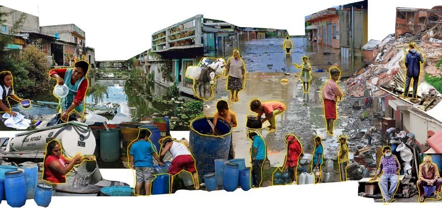
Imagine a city that built on a fresh water lake, 500 years back flourished as a civilization, but in present day gets inundated with every rainfall and simultaneously faces water shortage. That is Mexico City. And this makes you wonder how did we lose this shared cultural knowledge of living with water and where did we go wrong?
LOST in TRANSLATION, is an attempt to do an urban water repair using the lost shared cultural and indigenous knowledge of water management and trying to reestablish the symbiosis between water and community which could be key in creating more resilient communities of the future.
LOST IN TRANSLATION
SOCIAL CULTURE
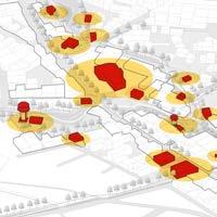
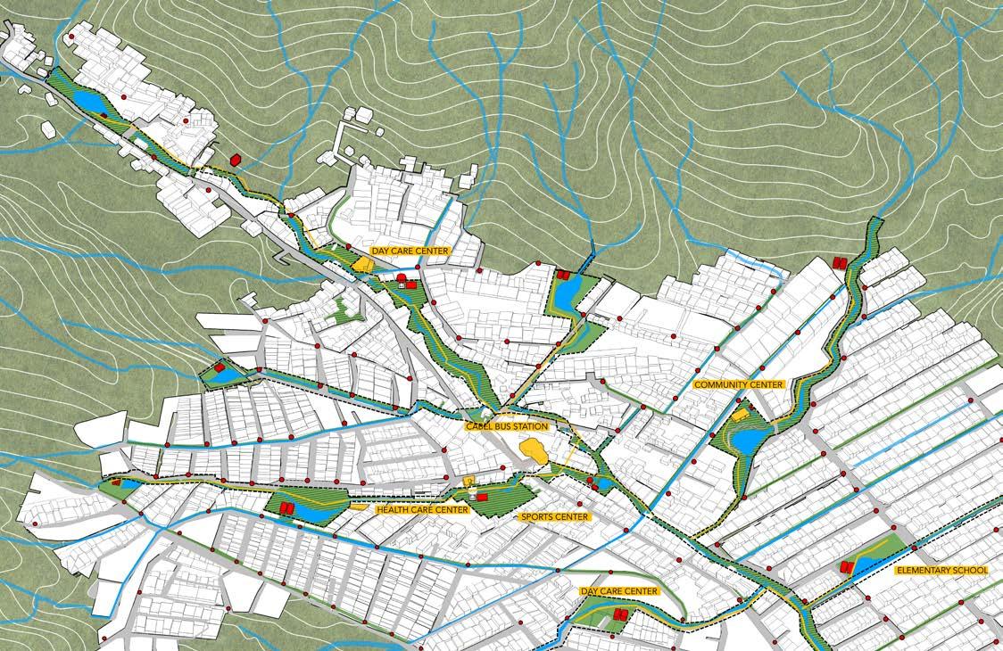
Social cultural nodes are where the people of the community intervene
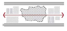
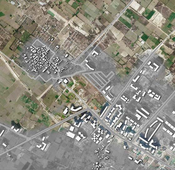
Rapid expansion normally happens on the borders and over time the government has tried redeveloping these illegal colonies and trying to make them regularized. The topography of the area where these informal settlements have developed over the years makes it difficult for the government to regularize these colonies, and equip them with required infrastructure.
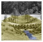
Thr proposal is tointroduce a Water Culture, an to create a stronger link with the urban, natural and cultural context of the public spaces. The vision is to leverage the natural hydrological system of the site, identifying and preserving the streams capturing the maximum possible rainfall, and reusing it for everyday use.
RE-ESTABLISHING THE SYMBIOSIS BETWEEN WATER AND COMMUNITY
URBAN DESIGN STRATEGY Urban WATER repair
Location: State of Mexico, CDMX
URBAN DESIGN | GREEN INFRASTRUCTURE | PUBLIC ENGAGEMENT | WATER URBANISM
Advisors:
Prof. CHRISTOPHER CALOTT
Prof. STEFAN PELLEGRINI
Prof. GABRIEL DIAZ MONTEMAYOR
Advanced Design Project MUD | 2022
4 page
FLASH FLOODS
40% WATER LOSS IN LEAKS AND TRANSPORTATION
WATER SCARCITY
HEALTH ISSUES
LANDSLIDES
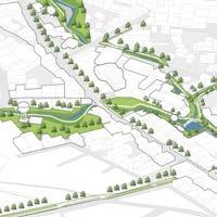
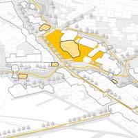
Blue Green network deals with the horological environment of the area and manages the runoff, avoiding flooding.
Urban Landscape deals with the existing fabric and looks into the mobility of the region and infrastructure required to work with the blue-green network
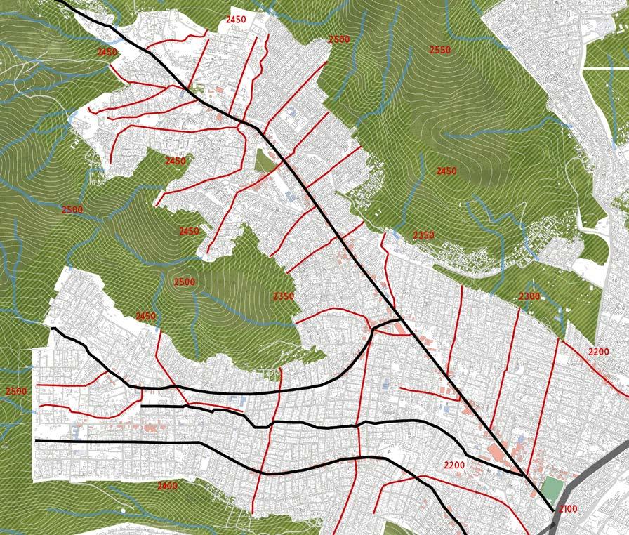
The rapid urban growth, use of concrete and disrupted slopes have diminished natural catchment areas and manipulated the waterways. The area receives close to 100mm of rain per cubic meter every month, and the lack of any water management techniques has led to the areas being yearly flooding leading to landslides, loss of property, and affecting the natural aquifers.
understanding the context story of the neighbourhood
The neglected natural streams and creaks have now become dumping grounds leading to health-related issues. And above all this like any other area in and around Mexico City faces water scarcity.
5 page
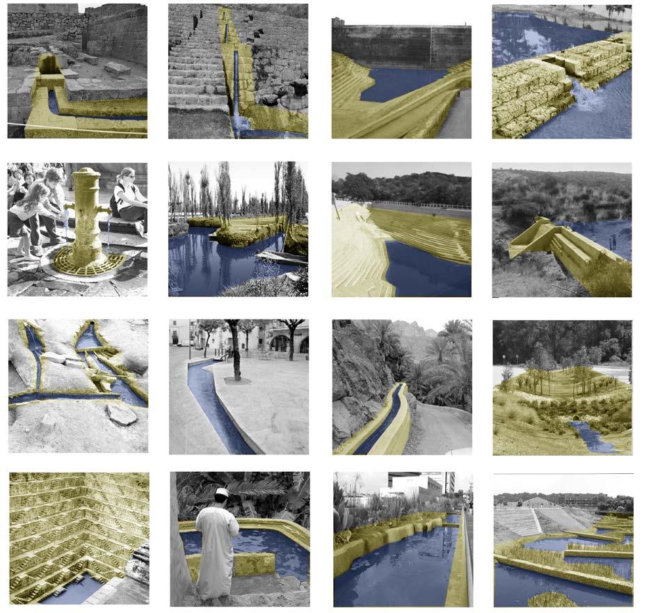
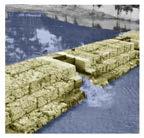
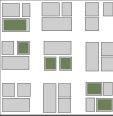
Learning from the indigenous water management techniques used all around the work a toolkit is created that would help us in achieving our goals of managing water in a sustainable way. These include Check dams, Aflaj system, Qanat system, Floating gardens of the Aztec era, stepped wells, Roman drinking fountains, constructed wetlands,tankas.
indegenous water management creating a toolkit
6 page
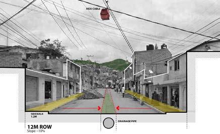
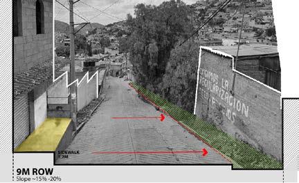
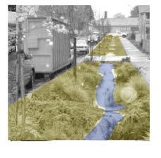
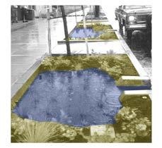
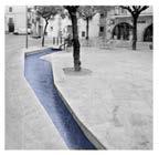
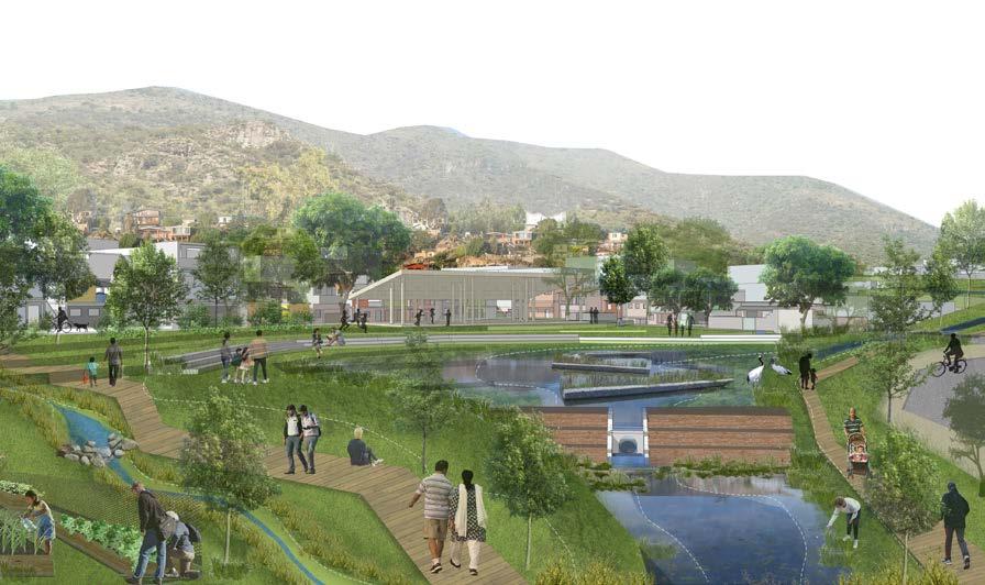
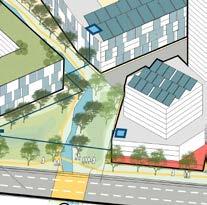
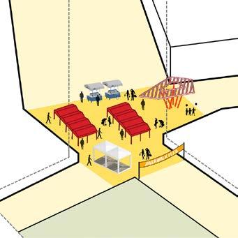
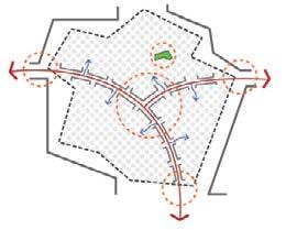
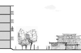
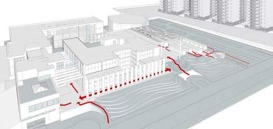
Capture and Filter : we collect the maximum run off possible by seizing the stormwater from the surrounding hills, streets and if possible the roofs of our public buildings. We create a network of green infrastructure of bioswales, retention ponds, rain gardens. This helps us is mitigating the flood risks and also clean out the water before it reaches our Storage tanks.
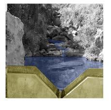
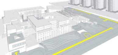
Store and Distribute : Storing the water at locations easily accesible to the public and Leveraging the topography we try to use gravity in distributing the water to our water commons for smaller blocks
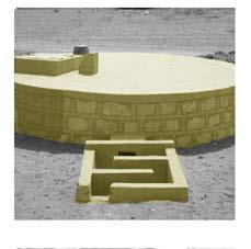
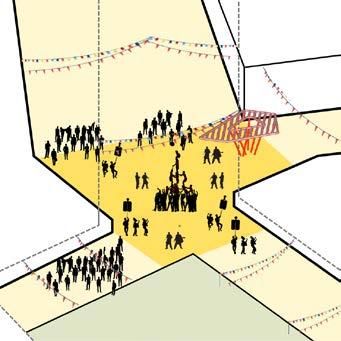
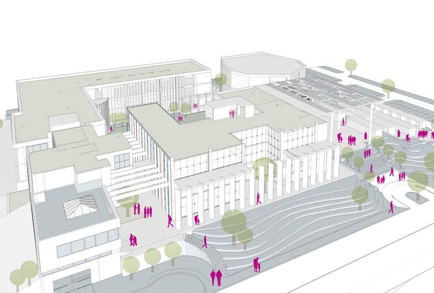
Water Commons : And lastly we animate ; adding the cultural/ social use to our bigger water commons to create spaces that people identify with and can create a sense of belonging. Provoking the community to maintain these spaces.
1 2 3 stormwater management hydrology
Re-establishing relation to water: Water culture and creating open spaces and new infrastructure practice can help in decentralizing the longer systems and help in creating more resilient communities.
7 page


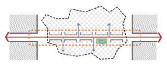
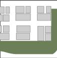
Colonias are divided into smaller blocks ,of say 900- 1000 households. To cater to this population, we need a water tank capacity of 2.2 mil liters. And this can provide 80 to 100 l of water per day for each household.
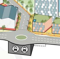
Leveraging the topography the water from these tanks can be distributed to lower altitude areas than the tank. The water gets transferred to a water common : fountain where people can come and collect water as per their requirement.
These water commons are available at a maximum of 3min walk from each household.
We try to utilize the residual spaces in the colonias, and Small interventions in which the community gets involved.
The Goal we are looking at through these insertions reduce flooding. Capture stormwater reuse water, water supply, recreational spaces, health benefits, connection to public mobility and create job opportunities.
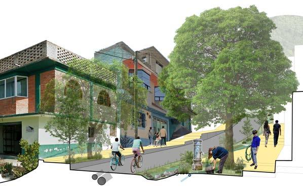
interventions the system
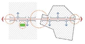
Utilizing the Residual Spaces. inserting Community uses, public toilets and waste collection places for waste treatment and creak cleansing are introduced as nodes along the system.
8 page PERFORATED UNDER DRAIN PIPE CHECK DAMS WIDENED SIDEWALK BIO-SWALES
smaller


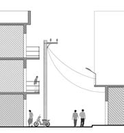
Harness the water. make water a part of the communities life. Instead of the body of water being perceived as the backyard and the garbage dump, it became the focal point that brings together the whole community and enriches the social-natural bond.
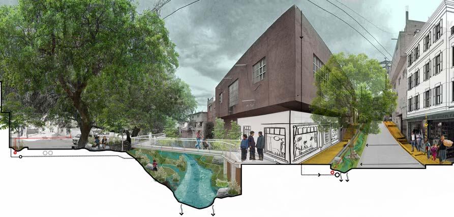
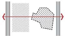
Impact on the private realm: by equipping our streets and open spaces we can also slow down the outward growth of urban fabric by densifying and activating the public realm.
9 page
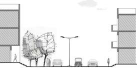
FILTERED WATER HOLDING POOL WATER COMMON EXTENDED COMMERCIAL FRONT
WIDENED SIDEWALK SPILL OUT ZONE
GRAVEL PIPE BED
STEPPED
smaller interventions water commons ACTIVE STREET FRONTAGE ADDED DENSITY PUBLIC MOBILITY INFRASTRUCTURE INCREASE TREE COVER
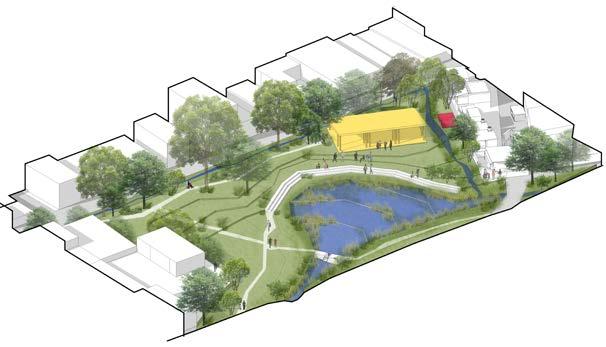
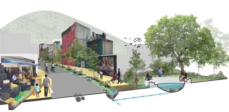
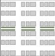
Normal rain.
Green Infrastructure coexisting with communal spaces.
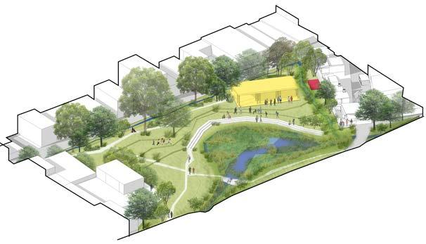
Dry rain.
The water holding pond transforms into a vegetated bank, with open spaces for kids to play.
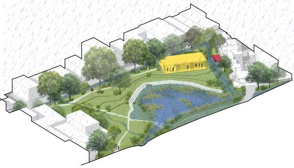
Extreme rain.
Larger Retention system, to hold extra water during floods.
The community space at high altitude can convert to disaster recovery center.
transforming through the seasons water commons

10 page
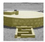
Activating the space.
Creating a landmark building to attract the community and promote activities that highlight the heritage
STEPPED WETLANDS : help in cleansing and recharging , filtration and deposition then sediment removal and nutrient removal. Aeration ponds also help in filtering the water. This is where water is harvested and reused for everyday uses.
URBAN FARMING, small scale community farming takes its opportunity to utilize the natural water resources , attempt to cultivate healthy urban culture.
agency pattern how things work PLANNING
BODY MUNICIPAL GOVERNMENT + + COMMUNITY BODY
Funding the planning and design initiatives
Designing for water sensitive urban design
Street and flood area analysis
Coordination
Creating community Consensus
Cleaning
Funding to maintain over time
Resident incentives
Creating a localized system of coperatives.
Design an approach towards development that creates the possibility of developing interventions that vertically integrate different kinds of solutions, taking into account infrastructure, culture, urbanism, the environment, and even the economy.
11 page
+ DESIGN FUND + IMPLEMENTATION OPERATION MAINTENANCE
EDUCATIONAL
To create a rivervoriented communities .
. connected by a robust network of blue & green infrastructure. . .
linking multiple welcoming neighborhoods . . .
integrated with its surroundings . . .
that Londoners today and tomorrow can call home.

CITY OF VILLAGES AN INTEGRATED LANDSCAPE
MASTER PLAN FOR THAMESMEAD
In an effort to plan for a community that is situated within the greater London region, we startd with the the question “What is London?”.
While exploring the city streets, experiencing the sites and tastes, and speaking with Londoners, we came to understand why people call London a City of Villages .IRREGULAR ∙ INFORMAL ∙ .INTIMATE ∙ INVITING
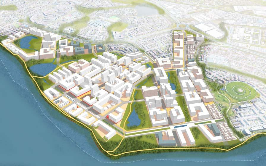
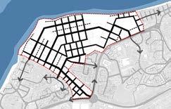
The idea was to create cluster of villages, using a the intersecting grid that allows us able to which creates these informal irregularities that can embrace the informality .
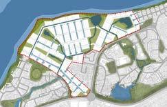
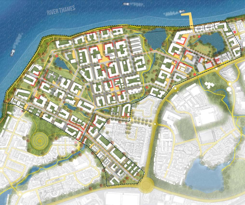
For the master plan, firstly, the existing canal network was restored to mimic natural processes and reestablishing their connection to the floodplain of the river. Secondly a system of greenways throughout the entire district was established following existing drainage patterns and the once inactive and ditatched riverfront edge becomes a new public space.
Location: Thamesmead, London
Mixed Use Development
Guide: John Ellis
2nd Semester MUD | 2022
Academic | Group
12 page
. .
.
. . .
.
.
. . .
.
.
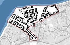
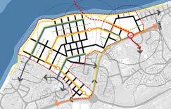
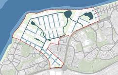
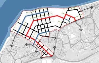
figure ground intersecting grid mobility 13,950 107 acres dwelling units buildable parcel BUS ‘LOOP ‘CANAL’ Streets Dedicated Cycle Lane Pedestrian Mews Bus Stop 5min walk Transit HUB- LRT stop green infrastructure hydrology 75 acres 15 acres public greens riverfront park street hierarchy 107 acres buildable parcel
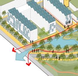
animating the public realm:
Our clusters of villages are tied with a series of multi use pathway that then is captivated with retail and community amenities at these nodes in between
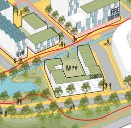
framing the plazas:
The massing of buildings is gradually stepping down in height towards the sensitive water frontage,and existing development, helping in integration with the existing development.
embellising each village story of the villages
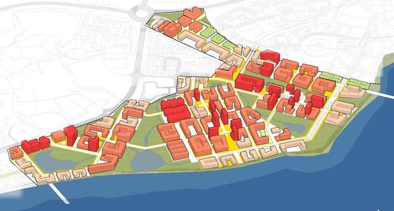
13 page 1 - 3 Floors 2 - 4 Floors 5 - 8 Floors 9 - 18 Floors land use strategy density strategy 23% 10% high rise towers
townhouses / low rise
The built form tries to create these smaller pocket plazas and greens : Village-like quality of the interior of each block. The master plan recognises the need to break down the urban blocks and edges to promote permeability and allow visually accessible residential buildings.
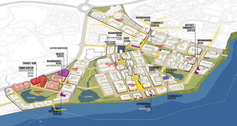
weaving the neighbourhoods master plan
Transit hub is located at the east corner of the site which allows it to become part of the larger context. Bike connection to the Thames path and greater London. Further loops around the villages as well.
Each Village has its own market center that helps us divide the commerce density all over the development animating the ground floor realm everywhere.
14 page
101
250 ac
area: 30 ha
75 ac
6
ac (6%) Buildable
43 ha
107 ac (48%)
area: 1.9M sq. m.
20.1M sq. ft.
units: 13,950 DU Density:
FAR
area: 138,000 sq. m. / 1.5M sq. ft. Retail area: 57,000 sq. m. / 615,000 sq. ft. THAMESMERE CENTERMERE BROOKSIDE PARK RIVERFRONT PARK WOODLAND PARK HISTORIC PARK 100ft 200ft N 500ft 1000ft 1 3 4 8 5 6 7 2 8 8 8 9 9 9 10 11 12 13 14 15 16 17 17 18 18 WOODLAND VILLAGE GATEWAY VILLAGE BROOKSIDE VILLAGE TUMPSIDE VILLAGE NEW-MARSH VILLAGE LONG ISLAND VILLAGE
Total area:
ha /
Green
/
Riverfront:
ha / 15
area:
/
Residential
/
Residential
2
Commercial
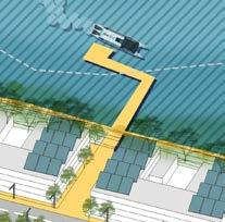
1- TRANSIT HUB 2- LIFESTYLE CENTER 3- INSTITUTE OF INNOVATION 4- THAMESMERE PARK 5- WATER TREATMENT PLANT 6- HEALTHCARE CENTER 7-ELECTRIC SUBSTATION 8- DISTRICT COMMUNITY CENTER 9-COMMUNITY MARKET 10-EXPERIENTIAL RETAIL 11-PRIMARY SCHOOL 12-SECONDARY SCHOOL 13-FERRY TERMINUS 14-BROOKSIDE PLAZA 15-WOODLAND PLAZA 16-HISTORIC DERELICT STRUCTURES 17-THAMES CANAL BOULEVARD 18-LOOP BOULEVAR
The two bio swales running along the main streets, helps in capturing the run off water, clean it and lead to the retention ponds on both ends.
The Riparian zone of the river is divided into 2 levels, floodable embankment and non floodable retail promenade.
The riv er edge is treated in two types : Hard edge and a softer edge with a berm as a flood mitigation method. This helps in creating variety of space and preserving the natural ecology of the place
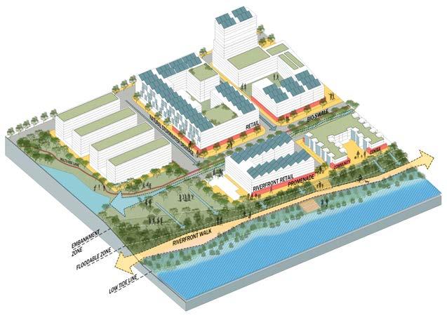

15 page THAMESRIVER 3 1 2 1 - Retention Pond 2 - Canal Street 1 1 2 1 - Canal Street 2 - Street Drainage 3 - Retention Pond 4 - Mixed Use Retail 2 1 2 3 4 1 - Riverfront Retail 2 - Riverfront Promenade 3 - Lower board walk - floodable 4 - Natural Reparian Zone 5 - Acessible river bed THAMESRIVER 3 1 2 3 4 5 stormwater management hydrology

So building on the sustainability strategy for the site, we recognize that the success of a master planned community of the scale we’re envisioning must be anchored by a mission-aligned economic driver.
2.2 FT avg.
4.8
In the first phase of our development, we’re proposing an institute for innovation in sustainable building design. The Institute will drive job growth, public realm activation, and make a “there” there, serving as a proof of concept for future phases

16 page phase
sustainability strategy transit center workplace productivity multiple mode of mobility social cohesion rain water harvesting sustainable building materials green roofs 1.1mil SQFT
1
load required
load through PV $22M capital cost
MW/day
3.0 MW /day
900k
100k
green spaces
commercial HVAC 275k
recycled
job creation solar shading structures reducing flood damage shared district heating and cooling stormwater catchment BIO-SWALES retention basin solar PV Panels reduce solar heat gain and support energy demand mass battery storage waste incineration + + + + + + ++ + + + + + + + + + + + + + + + + + + + + water management energy
annual rainfall
gal/day H2O sitewide
gal/day for
67k gal/day for
gal/day
H2O
generation
17 page
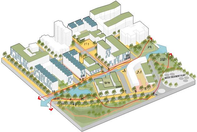
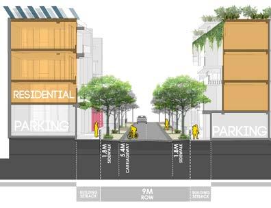
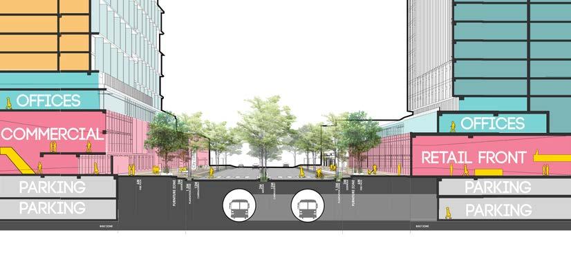
street through the gateway village.
LRT underground line running under the road, with underground parking for the lifestyle center and institute
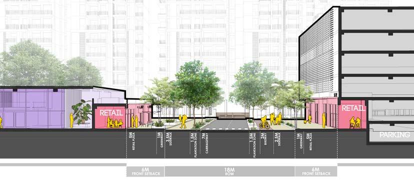
street through the brookside village
retail front street with minimal carriage way and maximised public walkway and dedicated bikelanes residential street with partial on street parking building roofs consisting of solar panels and vegetation
Primary ‘LOOP’ road ‘CANAL’ Streets Secondary Streets Mews
steet heiarachy

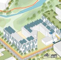
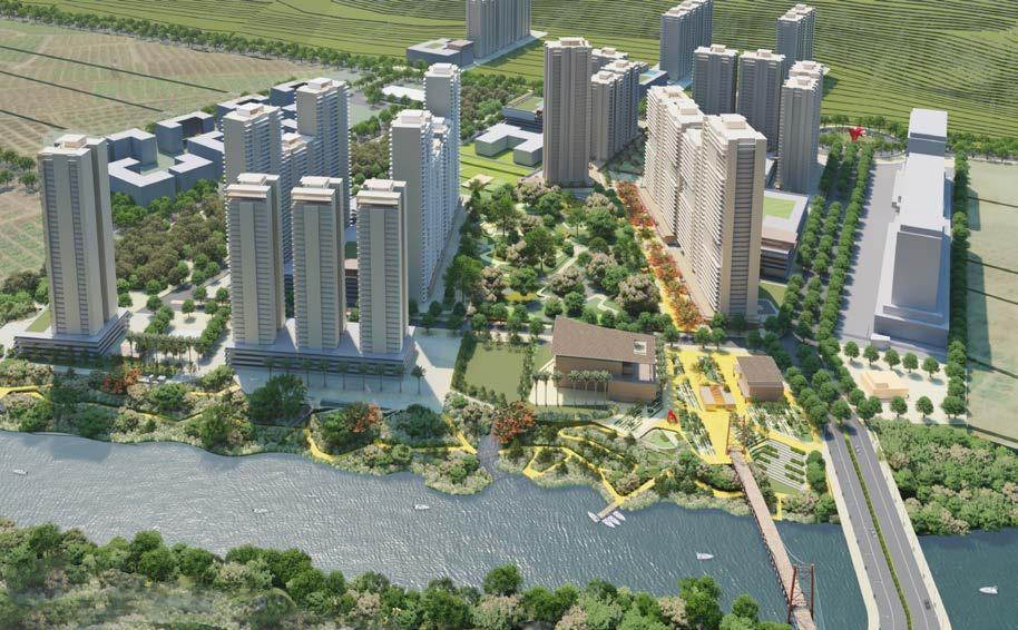
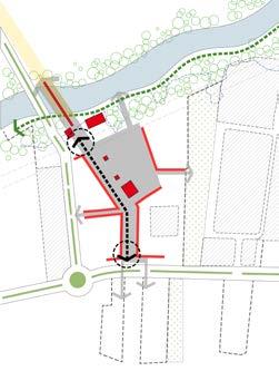
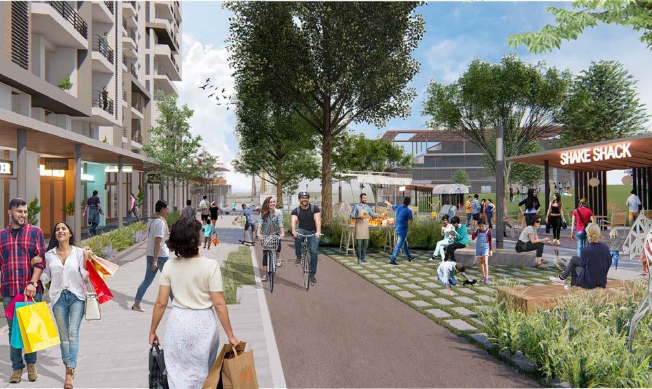
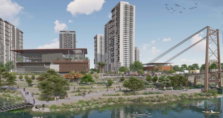
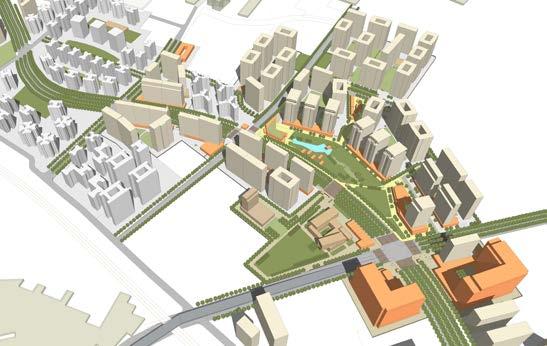
RIVERHILL PUNE creates a blueprint for a 80 acres high density community at the edge of Pune city. The plan departs from the typical privatized insular built typology and instead proposes a bold new Public open-space system for the cityThe RIVERWALK.
This highly public urban-device primarily sets out to meaningfully connect the site with the Riverfront and its envisions and the foothills onto the South side.
The Mula riverfront is a collective experience of the articulated edge of the Upper waterfront promenade, the ecological floodplains at the lower levels, as well as the rivers water-sheet.
The Heritage metal footbridge, the iconic clubhouse, and public marketplace act as the anchoring element for this waterfront edge.
RIVERHILLS
MIXED-USE RIVERFRONT NEIGHBOURHOOD
URBAN DESIGN - MASTER PLAN
Location: Pune, Gujrat, India
Master Plan | Mixed Use Development
Design Team (DADA Partners): Mukul Arora, Diksha Singh
Consultants: Stupio POD (Landscape)
Client : Godrej Properties Ltd.
Gross built area: 1.2 million sqft / 67 acre land
parcel
Professional | Group | 2019
18 page
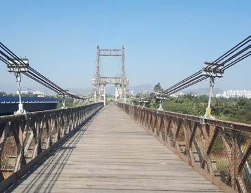
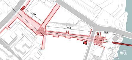
PEDESTRIAN METAL SUSPENSION BRIDGE : AN EXISTING ASSET
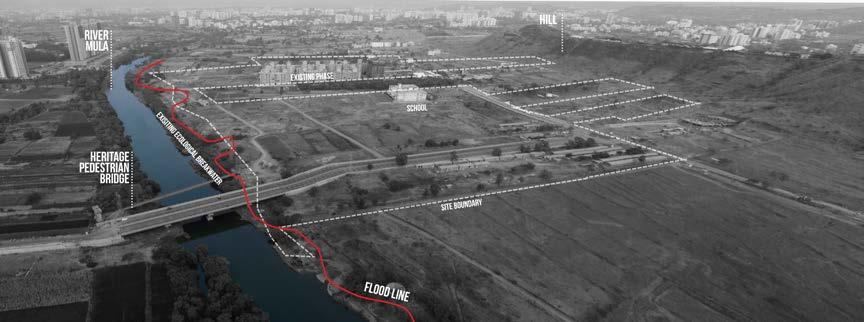
THE SITE AND CONTEXT
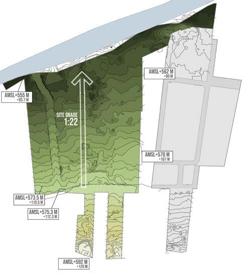
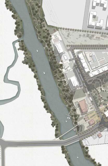
This project site is book ended by the tekari towards the south and river towards the north. The land has a significant and perceivable drop of around 30 metres along its full length.
Two major arterial DP roads bring easy access to the site from the Pune Mumbai highway from across the river from Hinjewadi.
The site is mostly devoid of natural or built context along its southern edge however on the northern edge the river, its floodplain, and the densely canopied embankment set up a strong context for the proposed layout plan.
The pedestrian metal bridge along the Northwest of the site is a highly visible physical asset and takes on the role of an anchoring element for the master plan.
site and surroundings
19 page
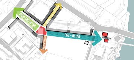
FROM HILLS T THE RIVER
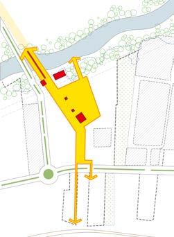
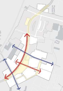
A PUBLIC FRAMEWORK CONNECTING HILLS TO THE RIVER
CREATING AN INTIMATE INWARD RIVERWALK EXPERIENCE ANCHORED BY A STRONG DESTINATION “TOWN CENTER “ AN EXCLUSIVE HIGH-QUALITY COMMUNITY ‘HIGH ON GREEN’ 3 2
"WHERE COMMUNITIES ARE FOCUSED AROUND NEIGHBOURHOODS"
A compact and socially diverse city where economic and social activities overlap and where communities are focused around neighbourhoods.
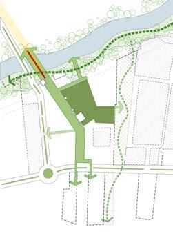
The township weaves the qualities of adjacent neighbourhoods into a rich tapestry of unique places. The precinct offers a wide variety of housing typologies and a network of open spaces.
vision and principles
20 page
1
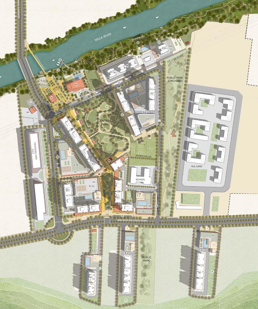
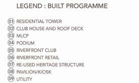

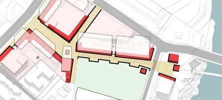
21 page master
plan
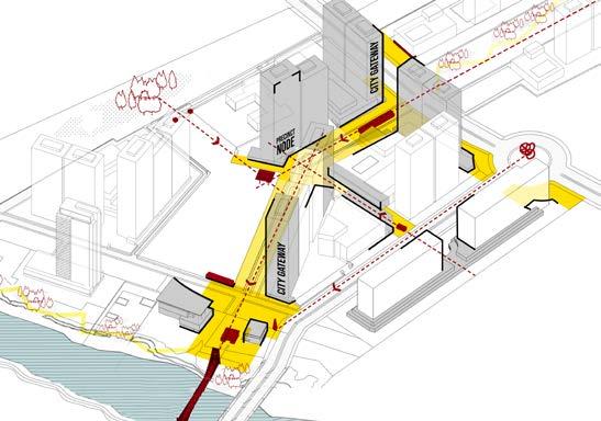
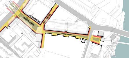
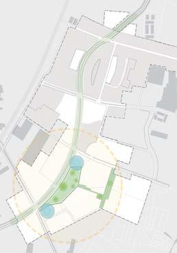
VIEW CORRIDORS AND NODES that act as keystones or multiple Public armatures; critical building surfaces or street walls that define the primary movement experiences; Tower locations acting as REGIONAL BEACONS for the project
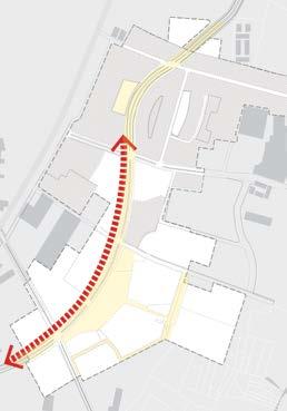
RIVERWALK
The RIVERWALK along the Main Street boulevard connects the riverfront and the Central Park with the urban front door of the project. This primarily pedestrian retail experience will be defined by inviting built edge as well as landscape gestures.
Multiple kiosks dotting the edges of the ecological bands and other landscape spaces such as amphitheater would allow for diverse set of activities.

22 page
3 2 3 2 1 1 riverwalk
River walk south defines the gateway along the DP road and a pedestrian mixed-use retail experience that is defined equally by the very urban spatial build quality as it is by the gently terracing open space design.
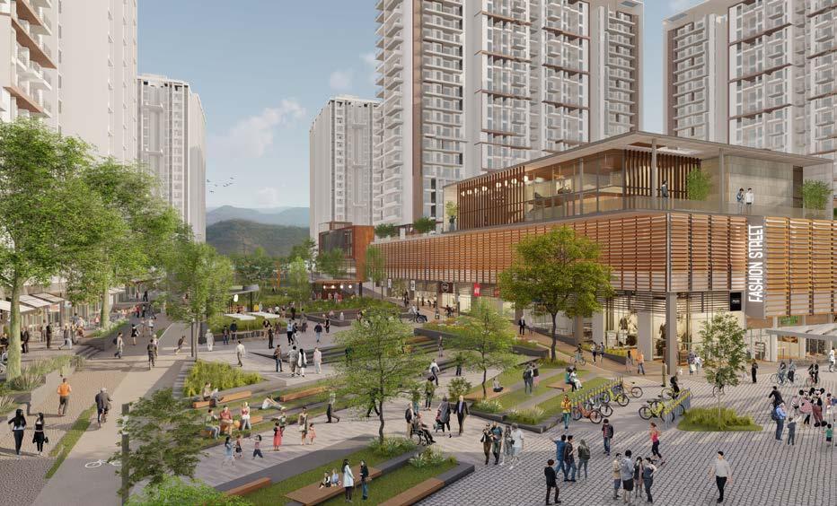
FASHIONSTREET
Assembling a 400m PUBLIC pedestrian spine NORTH RIVERWALK SOUTHRIVERWALK
Diversity of programming means multiple GO-TO SPACES
assembling the pedestrian riverwalk
River walk north is the one sided retail transitions into the large community green on the other side. The riverine inspired central landscape is punctuated by outdoor cafes and informal markets along its length.
Programmed, safe, and animated MIXED-USE GROUND PLANE
TRIPARTITE delineation of the space with middle zone as the eclogocal reserve
23 page
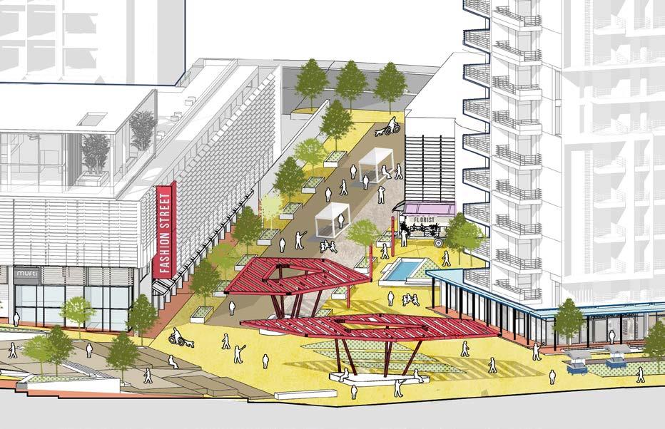
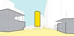
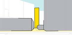
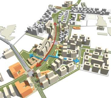
The 24X7 SOCIAL HUB of mahalunge. A pivotal point in the township that rivets ones gaze to the city spine and the hills above and the looming metal bridge over river Mula towards the north.
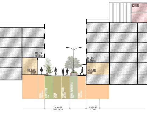


street wall diagram built to open ratio- 1:1
The chowk is where all pedestrian routes converge and it’s significance emerges from a pinwheel movement diagram which is a pattern commonly seen in our historic city fabric.
The narrow and shaded, Fashion Street is another such spatial device that is popular in the context of our social and climatic conditions. Part of the pin-wheel movement system, Fashion streets provides an important connect with the DP road along the west edge and the expected footfall form the SEZ parcel.
24 page
the chawk
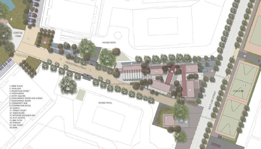
USE WAY
HEIGHT ANCHOR
FOOD STREET /PATIO ZONE
GATEWAY RETAIL
MULTI
DOUBLE
RETAIL
RESIDENTIAL
WEEKEND/ TEMPORARY
ICONIC SIGNAGE
COLONNADE RETAIL
TOWER
RETAIL
PRECINCT NODE MARKET CHAWK
HAWKERS ZONE
STREETSCAPE SECTION PLAN
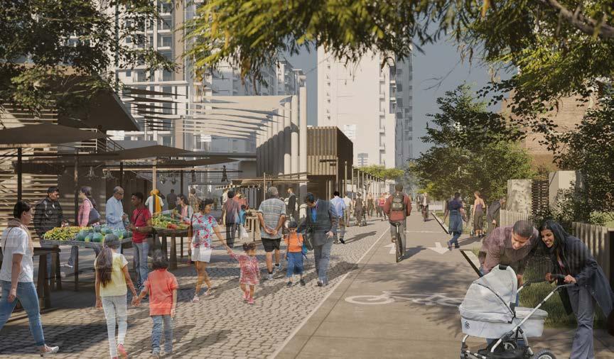
MONTHLY
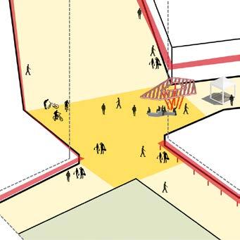
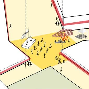
DAILY - DAY
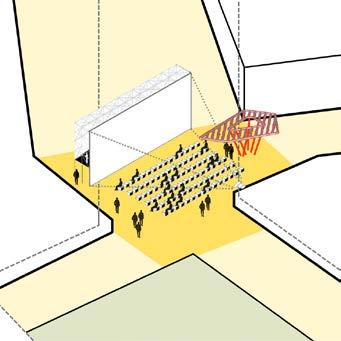
MONTHLY - OUTDOOR MOVIE/SPORTS MATCH SCREENINGS
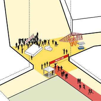
ANNUALLY- MARATHONS
DAILY - EVENING
MONTHLY- FLEA MARKETS/FAIRS
ANNUALLY- FESTIVAL CELEBRATIONS a versatile city space
25 page
DAILY
ANNUALLY
26 page 2 1 3 4
3 Enhanced
1
2
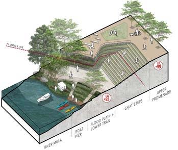
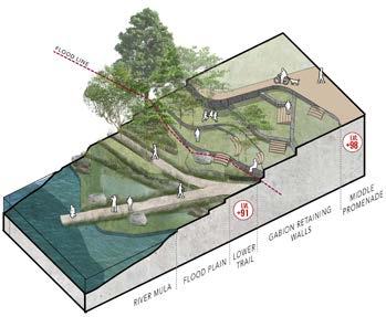
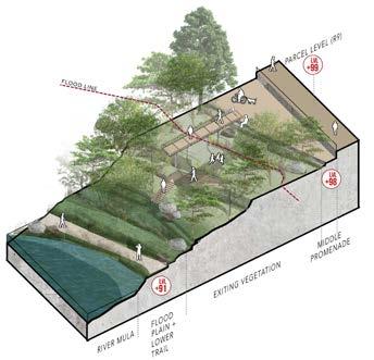
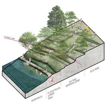
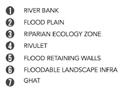
EDGE:
1 2 4 3 MAX access MIN access MEDIUM access MIN access HIGH access riverfront
Ecological Breakwater:
Ecological Breakwater Riverside park multilayered Promenade
Urban edge:
TERRACED gabion
Promenade +ghats
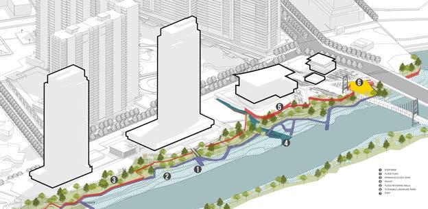

Of all the districts this one has the most ecologically sensitive zone Elements such as the ghats, and ramps act as the important connecting devices for this undulating rivers edge. They also allow users to access the river water from the upper parts of the promontory.
The Rivers watersheet is also considered as a hydrological extension or appendage to the ecological land-based system described above. Activities such as religious rituals, leisure, boating, swimming, etc are all everyday activities that have been programmed in the master plan.
componenets of a river edge
27 page
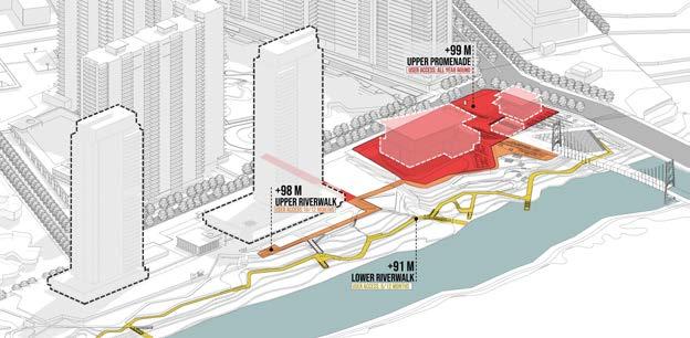
New Waterfront establishes a model for integrating civic park and public space design into urban flood protection
A UNIQUE PROMONTORY SETTING TO ENJOY THE MULA RIVER ECOLOGY
BALANCING THE “PUBLIC & PRIVATE” ZONES
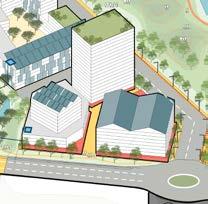
Godrej Garden City master plan creates a blueprint for a high density community at the periphery of Ahmedabad’s urban city core. The plan primary draws inspiration from the way of life in which residents still embrace mixed-use fabric; a way of life where public open spaces and bazaars are frequented by the community year round, a nod to the very essence of urban coexistence
At the most fundamental level the plan firmly sets the intent for a new town that is held together by a genuine and active public realm, while optimising the insatiable and prosaic demand for high density development parcels.
EXTENDING THE CITY MIXED-USE DYNAMICS
The design process entailed formulation of detailed urban design codes and guidelines as an essential companion to the masterplan.
UD guidelines here would become a critical tool that will ensure coordinated incremental action, by various stakeholders over a long term timelines.
Since design is not a science, this approach ensures that the seam between the private and public has clear definition
Location: Ahmedabad, Gujrat, India
Master Plan | Mixed Use Development
Design Team (DADA Partners): Mukul Arora, Diksha Singh
Consultants: BDP (Landscape)
Client : Godrej Properties Ltd.
Gross built area: 17 million sqft / 85 acre land
parcel
Professional | Group | 2018
28 page
MASTER
PLAN

SITE
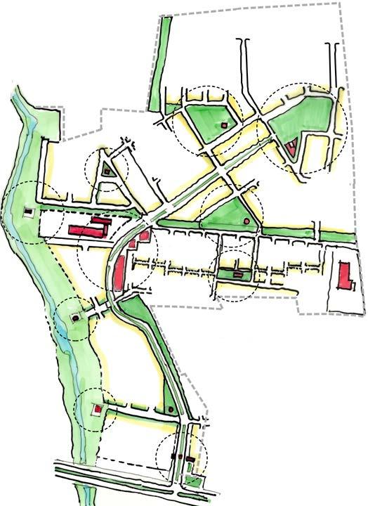
The already built early phases at GGC, totaling around 70 acres has emerged from an earlier SOM master plan. This district comprises of six well established mid density housing communities totaling 4500 apartments, school, and marketplace. The residents also enjoy two well designed public parks along with a centralized clubhouse. The highlight of this development though is the curvilinear grand boulevard that runs North-south through the middle of the site
REGIONAL
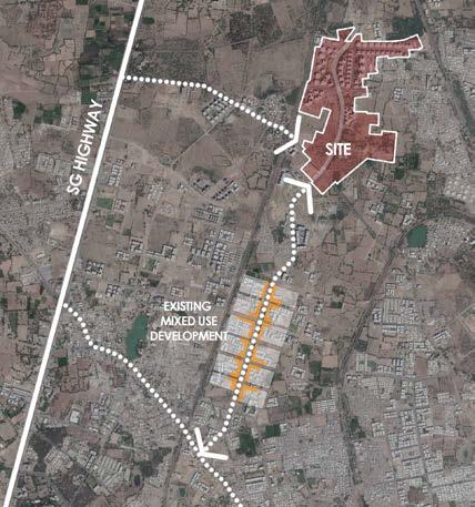
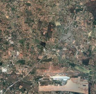
GGC is a 160 acre township located in Jagatpura, which lies in North West of Ahmedabad within the Municipal Corporation city limits. The long linear land parcel is nestled between railroad spurs on either side, through the proposed railroad bridge connector along new SG road, the site shall be closely connected with the S.G Highway to the west. The site is 7km away from the Sabarmati railway station while the international Airport is 18 Km away.
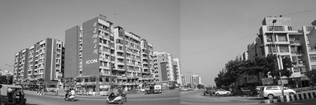
Unlike the other greenfield sites across the country, the new growth area abutting the site, especially towards the south is remarkable in the way each new incremental city block is creating a well anchored mixed-use neighbourhood with a balanced street and block pattern.
site and surroundings
29 page
MIXED USE DEVELOPMENT AROUND THE SITE
2 KM LESS BOUNDARY WALLS
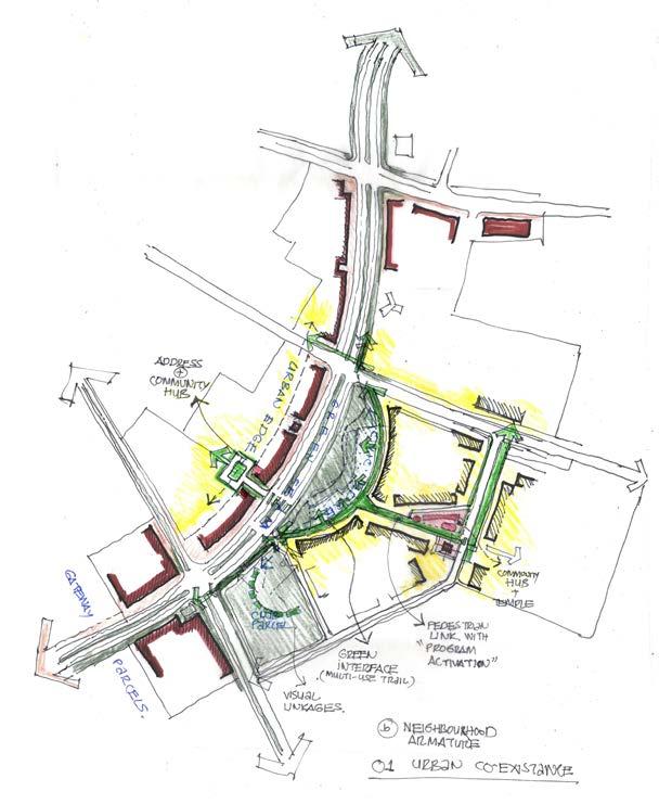
Highly accessible mixed-use edges to define the 85 acre township so as to revive the wisdom of the traditional settlement patterns, both, in east and the west.
1.25 ACRES COMMUNAL HUB
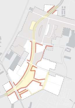
Fully pedestrianized Cross Armature allows the residents to move efficiently, conveniently, and safely.
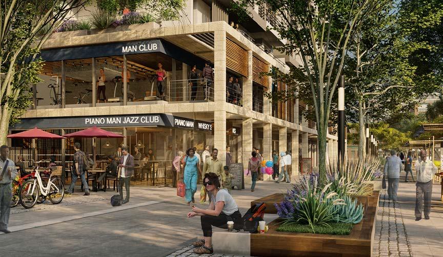
1 KM SHADED COLONNADE
The one km long curvilinear highly image able retail colonnade that acts as a ‘civic’ insert and a climate sensitive amenity for the residents and visitors
6 ACRES PLUS CITY LUNGS
The Intensely programmed six acre central park with animated retail along its edge becomes the playground and entertainment hub for the township
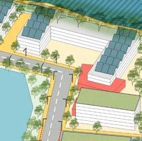
A one kilometer long shaded retail colonnade lines the western edge of this urban space while the opposite edge is defined by well-articulated mixed-use built podium edge with housing towers above. This primary north-south citywide armature is crossed by a scaled-down neighbourhood connector.
A fine textured street-block pattern creates the appropriate physical setting for a community driven lifestyle in close adjacency to a very high energy urban corridor. These spaces are activated by allocating a diverse range of active programing for the public edges.
30 page
urban design process

primary and secondary city armatures
At one end of this cross-armature is the large city level clubhouse, and as one moves across the Central Park it transitions into an intensely used pedestrian environment surrounding high density housing blocks.
31 page Gateway Commercial Central Park City Club Colonnade Retail Lifestyle Retail Festive Market Park Retail Mandir Gali Community Retail Sports Plaza 1 2 3 4 5 6 7 8 9 10 1 1 2 3 4 5 6 7 8 9 9 10 13 40M ROW BOULEVARD CENTRAL PARK 2 3 4 5 6 9 10 11 24MROWDPROAD 18MROWROAD 30M ROW DP ROAD NEIGHBORHOODSPINE COMMUNITY CLUB 7.37 Ac. 40M ROW BOULEVARD 12 15M WIDE FLYOVER MARKET STREET 18M ROW NHBD AVENUE 12MROWNHBDSTREET TEMPLE 7 8 2.9 Ac. 3.9 Ac. 2.8 Ac. 7.8 Ac. 6.8 Ac. 4.3 Ac. 6.4 Ac. 5.8 Ac. 6.3 Ac. 0.5 Ac. 3.4 Ac. 2.4 Ac. 1 Ac. 1A 3.6 Ac. 15 1.2 Ac. 1B 14 NEIGHBORHOOD STREET AUDA GREEN EXISTINGNEIGHBORHOODCLUB ORCHARD SECTOR TIVOLI SECTOR BELVEDERE SECTOR 2.5 10 20 50 100 DETAILED SCHEMATIC MASTER PLAN GODREJ GARDEN CITY, AHEMDABAD SUPER AREA - 15,77,002 SQM / 1,6974,708 SQFT TARGET AREA - 16,40,354 SQM / 1,76,56,623 SQFT TOTAL PARCEL AREA -74,06 ACRES CLUB PARCEL – 7.5 ACRES
master plan
This neighbourhood Armature is strategically activated by the positioning of a convenience retail block, a small temple plaza, and a linear outdoor sports plaza for active recreation; all held together by a pedestrian precinct.
Multiple housing parcels are designed to have their pedestrian gates open directly onto the precinct, making it an ideal family centric place.
32 page community spine
Segregated roof allows for exploring lighter design for the colonnade roof, offers privacy of a segregated balcony to housing unit above, and might allow for services on the retail roof.
The sections (above) capture the variations possible within the threshold zone.
The residential towers building type and its structural bay shall inform the structural rhythm of the retail podium and hence the colonnade. Given the colonnade needs to work with a singular-or near singular- structural rhythm; the typical housing floorplate has been organized in a grid of 3M.
33 page guidelines
TOWER ARTICULATION ZONE 3M (MAX HT ) 3.3 M TO 3.5 M 3.3 M TO 3.5 M BASE BUILT TO LINE OUTER BUILT EDGE INNER BUILT EDGE COLONNADE ZONE BASE BUILT TO LINE OUTER BUILT EDGE BALCONY EDGE INNER BUILT EDGE TOWER ARTICULATION ZONE SHOP SHOP MAX 2.5 M MIN 2 M MAX 3 M MAX 2.5 M MIN 2 M UNIT 2 PODIUM AND TOWER ASSEMBLAGE PARCEL BUILDING LINE OPTION 2: RETAIL CENTRIC UNIT 1 RESIDENTIAL OPEN SPACE STORE OPTION NOTE : - MENTIONED HEIGHTS ARE FLOOR TO FLOOR HEIGHT INNER BUILT EDGE BASE BUILT TO LINE OUTER BUILT EDGE INNER BUILT EDGE TOWER ARTICULATION ZONE SHOP SHOP MAX 2.5 M MIN 2 M UNIT 2 PODIUM AND TOWER ASSEMBLAGE OPTION 2A: RETAIL CENTRIC UNIT 1 RESIDENTIAL OPEN SPACE NOTE : - MENTIONED HEIGHTS ARE FLOOR TO FLOOR HEIGHT DUPLEX 'LINER' HOUSE EXTENDED PODIUM BEDROOM SEGREGATED VS INTEGRATED ROOF CONDITIONS TOWER ARTICULATION ZONE 3M (MAX HT ) 3.3 M TO 3.5 M 3.3 M TO 3.5 M BASE BUILT TO LINE OUTER BUILT EDGE INNER BUILT EDGE COLONNADE ZONE MAX 2.5 M MIN 2 M MAX 3 M TOWER ARTICULATION ZONE 3M (MAX HT ) 3.3 M TO 3.5 M 3.3 M TO 3.5 M BASE BUILT TO LINE OUTER BUILT EDGE INNER BUILT EDGE COLONNADE ZONE BASE BUILT TO LINE OUTER BUILT EDGE BALCONY EDGE INNER BUILT EDGE TOWER ARTICULATION ZONE SHOP SHOP MAX 2.5 M MIN 2 M MAX 3 M MAX 2.5 M MIN 2 M UNIT 2 PODIUM AND TOWER ASSEMBLAGE PARCEL BUILDING LINE OPTION 2: RETAIL CENTRIC UNIT 1 SHOP SHOP UNIT 2 PARCEL BUILDING LINE RESIDENTIAL OPEN SPACE STORE OPTION NOTE : - MENTIONED HEIGHTS ARE FLOOR TO FLOOR HEIGHT PODIUM OPTION RESIDENTIAL OPEN SPACE NOTE : - MENTIONED EXTENDED PODIUM HVAC UNIT OPTION 1 : MAXIMIZED RETAIL OPTION 2A : HOUSING CENTRIC OPTION 2B : RETAIL CENTRIC TOWER ARTICULATION ZONE 3M (MAX HT 3.3 M TO 3.5 M 3.3 M TO 3.5 M BASE BUILT TO LINE OUTER BUILT EDGE INNER BUILT EDGE COLONNADE ZONE BASE BUILT TO LINE OUTER BUILT EDGE BALCONY EDGE INNER BUILT EDGE TOWER ARTICULATION ZONE STORE OPTION MAX 2.5 M MIN 2 M - MENTIONED HEIGHTS ARE FLOOR TO FLOOR HEIGHT MAX 3 M MAX 2.5 M MIN 2 M TOWER ARTICULATION ZONE 3M (MAX HT 3.3 M TO 3.5 M 3.3 M TO 3.5 M BASE BUILT TO LINE OUTER BUILT EDGE INNER BUILT EDGE COLONNADE ZONE BASE BUILT TO LINE OUTER BUILT EDGE BALCONY EDGE INNER BUILT EDGE TOWER ARTICULATION ZONE SHOP SHOP MAX 2.5 M MIN 2 M MAX 3 M MAX 2.5 M MIN 2 M UNIT 2 PODIUM AND TOWER ASSEMBLAGE PODIUM AND TOWER ASSEMBLAGE PARCEL BUILDING LINE OPTION 1: HOUSING CENTRIC OPTION 2: RETAIL CENTRIC UNIT 1 SHOP SHOP UNIT 2 UNIT 1 UNIT 1 PARCEL BUILDING LINE RESIDENTIAL OPEN SPACE RESIDENTIAL OPEN SPACE STORE OPTION - MENTIONED HEIGHTS ARE FLOOR TO FLOOR HEIGHT BASE BUILT TO LINE OUTER BUILT EDGE INNER BUILT EDGE TOWER ARTICULATION ZONE MAX 2.5 M MIN 2 M PODIUM AND TOWER ASSEMBLAGE OPTION 2A: RETAIL CENTRIC RESIDENTIAL OPEN SPACE - MENTIONED HEIGHTS ARE FLOOR TO FLOOR HEIGHT DUPLEX 'LINER' HOUSE EXTENDED PODIUM BEDROOM TOWER ARTICULATION ZONE 3M (MAX HT 3.3 M TO 3.5 M 3.3 M TO 3.5 M BASE BUILT TO LINE OUTER BUILT EDGE COLONNADE ZONE MAX 2.5 M MIN 2 M MAX 3 M TOWER ARTICULATION ZONE 3M (MAX HT 3.3 M TO 3.5 M 3.3 M TO 3.5 M BASE BUILT TO LINE OUTER BUILT EDGE INNER BUILT EDGE COLONNADE ZONE BASE BUILT TO LINE OUTER BUILT EDGE BALCONY EDGE INNER BUILT EDGE TOWER ARTICULATION ZONE SHOP SHOP MAX 2.5 M MIN 2 M MAX 3 M MAX 2.5 M MIN 2 M UNIT 2 PODIUM AND TOWER ASSEMBLAGE PARCEL BUILDING LINE OPTION 2: RETAIL CENTRIC UNIT 1 PARCEL BUILDING LINE RESIDENTIAL OPEN SPACE STORE OPTION - MENTIONED HEIGHTS ARE FLOOR TO FLOOR HEIGHT TOWER ARTICULATION ZONE 3M (MAX HT 3.3 M TO 3.5 M 3.3 M TO 3.5 M BASE BUILT TO LINE OUTER BUILT EDGE INNER BUILT EDGE COLONNADE ZONE BASE BUILT TO LINE OUTER BUILT EDGE INNER BUILT EDGE TOWER ARTICULATION ZONE SHOP SHOP MAX 2.5 M MIN 2 M MAX 3 M MAX 2.5 M MIN 2 M UNIT 2 PODIUM AND TOWER ASSEMBLAGE PARCEL BUILDING LINE OPTION 2A: RETAIL CENTRIC UNIT 1 RESIDENTIAL OPEN SPACE - MENTIONED HEIGHTS ARE FLOOR TO FLOOR HEIGHT DUPLEX 'LINER' HOUSE EXTENDED PODIUM BEDROOM TOWER ARTICULATION ZONE 3M (MAX HT 3.3 M TO 3.5 M 3.3 M TO 3.5 M BASE BUILT TO LINE OUTER BUILT EDGE INNER BUILT EDGE COLONNADE ZONE BASE BUILT TO LINE OUTER BUILT EDGE BALCONY EDGE INNER BUILT EDGE TOWER ARTICULATION ZONE STORE OPTION MAX 2.5 M MIN 2 M - MENTIONED HEIGHTS ARE FLOOR TO FLOOR HEIGHT MAX 3 M MAX 2.5 M MIN 2 M ARTICULATION ZONE ZONE BASE BUILT TO LINE OUTER BUILT EDGE BALCONY EDGE INNER BUILT EDGE ARTICULATION ZONE SHOP SHOP 2.5 M MIN 2 M 3 M MAX 2.5 MIN 2 M UNIT 2 PODIUM AND TOWER ASSEMBLAGE PODIUM AND TOWER ASSEMBLAGE PARCEL BUILDING LINE OPTION 1: HOUSING CENTRIC RETAIL CENTRIC UNIT 1 SHOP SHOP UNIT 2 UNIT 1 UNIT 1 PARCEL BUILDING LINE RESIDENTIAL OPEN SPACE STORE OPTION MENTIONED HEIGHTS FLOOR FLOOR HEIGHT TOWER ARTICULATION ZONE 3M (MAX HT 3.3 M TO 3.5 M 3.3 M TO 3.5 M BASE BUILT TO LINE OUTER BUILT EDGE INNER BUILT EDGE COLONNADE ZONE BASE BUILT TO LINE OUTER BUILT EDGE INNER BUILT EDGE TOWER ARTICULATION ZONE SHOP SHOP MAX 2.5 M MIN 2 M MAX 3 M MAX 2.5 M MIN 2 M UNIT 2 PODIUM AND TOWER ASSEMBLAGE PARCEL BUILDING LINE OPTION 2A: RETAIL CENTRIC UNIT 1 RESIDENTIAL OPEN SPACE - MENTIONED HEIGHTS ARE FLOOR TO FLOOR HEIGHT DUPLEX 'LINER' HOUSE EXTENDED PODIUM BEDROOM MIXED-USE BLOCK TYPOLOGY : COLONNADE TYPE podium and tower assemblance
SCHEMATIC RETAIL PLAN - GROUND +FIRST LEVEL UP DN CORE INNER BUILT EDGE ABOVE BASE BUILT TO LINE (B.BL) ABOVE COLONNADE OUTER BUILT EDGE OUTER BUILT EDGE BASE BUILT TO LINE (B.BL) ABOVE CORNER SHOP TYPE 1 3000 3000 3000 3000 3000 3500 3500 3500 3000 3500 3000 3500 3000 3500 2350 SHOPS TYPE 2 RESIDENTIAL ENTRY RETAIL ENTRY RETAIL ENTRY GROUND FLOOR FIRST FLOOR RESIDENTIAL ENTRY SHOPS TYPE 3 SHOPS TYPE 4 CUTOUT BELOW CUTOUT ABOVE COLONNADE ZONE CORRIDOR PODIUM EXTENDS UNIT A A A A A B B B A B A B A B C STORE MAX 14.5M MAX 5.5M MAX 7 M MAX 3M
COLONNADE : ELEMENTS AND SIGNAGE
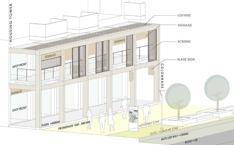
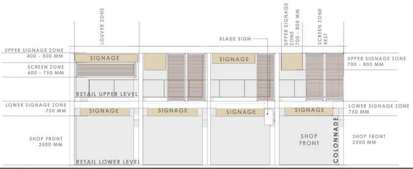
COLONNADE ELEVATION : OPTIONAL CONFIGURATION
Lower retail shops to have signage on top of the storefront itself. However smaller ‘Blade signage’ might be permitted for lower shops along the colonnade outer columns
Upper shops shall have signage along the outer colonnade face. These shall strictly adhere to the signage zone as suggested in the elevation above.
To create a harmonious experience the Building plinth as well as promenade levels need to be consistent across the project. The following levels have suggested for parcels along the GGC boulevard with the intent of creating a seamless landscape and building threshold experience.
34 page
guidelines
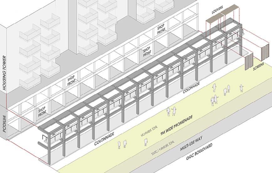
ASSEMBLING THE COLONNADE
The master plan carefully calibrates the ‘built and open relationships’ or edge types for the township so as to bring imageability and cohesion to the urban fabric and also variety where necessary.
The edges that have been appropriated at GGC also play an important part in providing safe and comfortable outdoor movement spaces for the pedestrians all year round.
35 page
guidelines
RESERVE PLOTTED NEIGHBOURHOOD
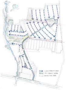
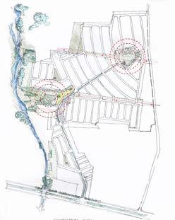
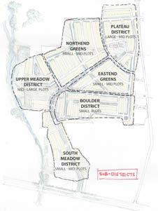
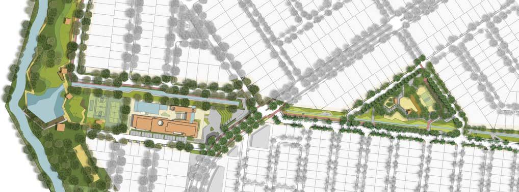
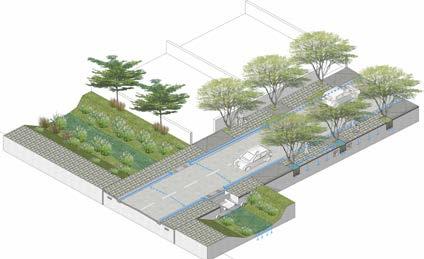
The structure for the master plan primarily emerges from a deep understanding of the unique landform of the site. The main armature of the plan is city-wide boulevard which meanders and ascends the site from lowest part, along the entry point, and culminates at the foot of the proposed Nandi Hill Park; the highest precinct of the site. The secondary street network emerges from this spine and is aligned so as to hug the contour levels/ lines of the site.
Subtle street and block manipulations also help generate surprising array of small neighbourhood parks and plazas throughout the township. Vistas, terminuses, enclosures,street edges, and intersections, have been designed carefully in terms of perception of residents moving along the street. In a way the street design is a balanced coupling of engineering, water management, and pictorial setting.
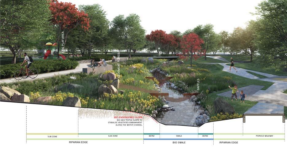
The streets at Godrej Reserve have been designed as per LID or Low Impact Development streets guidelines. LID or ECO-streets are designed favouring ‘soft engineering’ and vegetated treatment to manage rainfall conveyance
Location: Devanhalli, Bangalore
Plotted Master Plan
Principle Master Planner : Mukul Arora Team : Diksha Singh | Saurabh Syal
Landscape Architect : Landart Architects
Professional | Group | 2018
36 page
MASTER PLAN


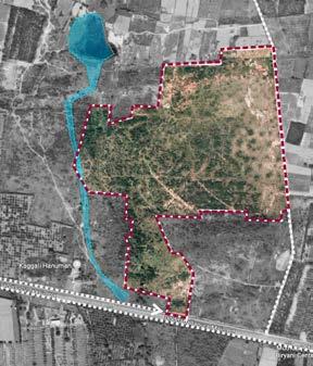
Godrej Reserve is a 100 acre proposed master planned community situated along 80m wide NH 648 , just north of Bangalore Airport. The land parcel is a picturesque setting of a consistently rising terrain dotted with local granite outcrops. The site also offers spectacular view of the Nandi Hill towards the north as well as the Kaggali Hanuman Temple along the Southwest tip. Two HT lines run across the site along the E -W direction.
The project offers a net built-up area of around 1,77,500sqm in the form of 950 plots with an average density of 10 plots to an acre. These plots offer a sustainable mix of small-to-mid-to-large sizes varying from 110sqm to 300sqm.
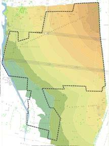
A seasonal drain runs N-S along the western edge of the site, which also is the lowest part of the landform. Given the average gradient of around 1:50, the site drains into this natural system and to manage this, a stormwater collection system was introduced.
The Urban Stromwater infrastructure enhances the ecological functioning to serve as a civic asset without being a environmental liability.
Low Impact Development (LID) is an ecologically based stromwater management approach favouring soft engineering to manage rainfall on site through a vegetated treated network.
37 page
TEMPLE ACCESS ROAD +112 M +95 M SLOPE +100 M
NANDI HILL
Landscape Architects Pune 06 April 2018 Location Context Nandi Hills The Site Devanhalli
Hillock Temple regional hydrology
Landart Designs
Kempegowda Airport
01 A PLAN THAT WORKS WITH CONTOURS
The structure or framework emerges from a deep understanding of the unique landform of the 100 acres
02 CONVEYANCE
Water conveyance shall be the generator of landscape design and low-impact infrastructure design
03 PLACEMAKING - 2 ANCHORS
The plan is an assemblage of an iconic spine- the boulevard- and two anchors- the club and Nandi hill park. HIGHEST WITH THE LOWEST POINT
04 SUB DISTRICTS
Creates multiple special addresses or subneighbourhoods in the township each with its own unique identity
38 page
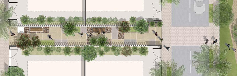
design development
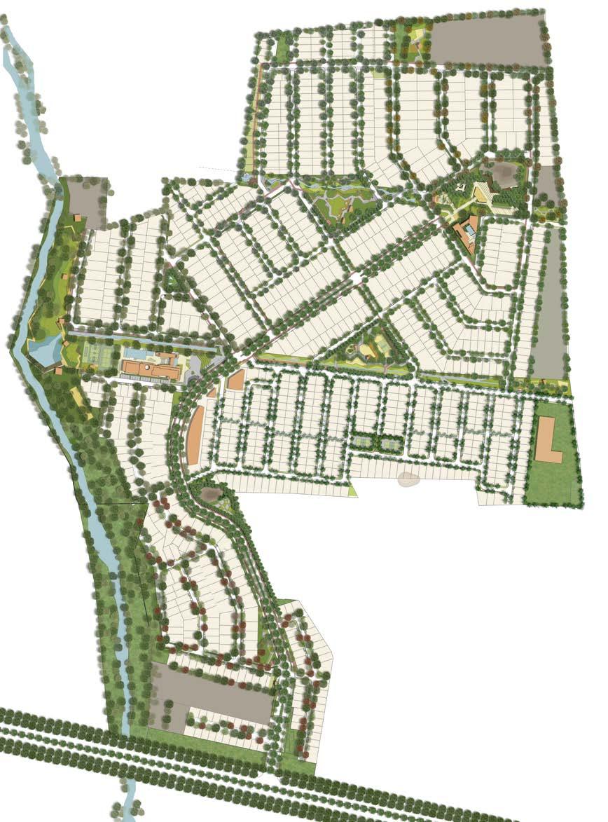
39 page 0 20 50 100 M STRR STRR STRR STRR CA HILL VIEW PARK CENTRAL GREENWAY PARK SOUTH BIO-SWALE NORTH BIO-SWALE SOUTH GREENWAY PARK SCHOOL CLUB HOUSE 1 FOREST CLUB HOUSE 2 BOULDER POINT NEIGHBOURHOOD PARK KEYSTONE PARK MEADOW PARK 90MDODDABALLAPURAMAINROAD WIDESATELLITETOWNRINGROAD 18M BOULEVARD 18MBOULEVARD RETAIL site plan
Creating well defined and an intensely interconnected OPEN SPACE AND SAFE environment
A series of well landscaped promenades, progressive street-way systems, and a generous park system has been designed as the framework for the township. The high quality streets and fragile block pattern has been consciously designed to create a porous and interconnected community.
This allows for the many activities of daily living to happen within walking distance, allowing independence to those who do not drive; especially the elderly and the young; and enable neighbours to know each other and protect their communities
OPEN SPACE NECKLACE CONNECTING SUBDISTRICT NODES
40 page
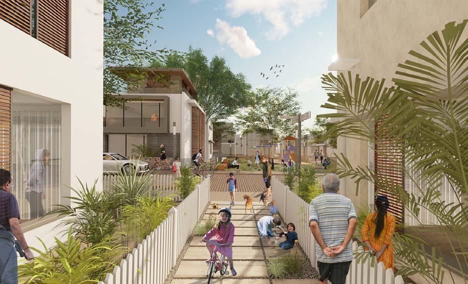
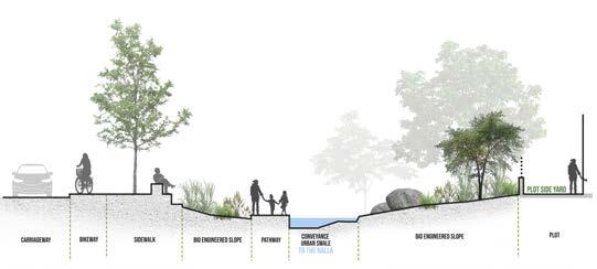
SETBACK LINE MID BLOCK ALLEY
ZONE SIDEWALK BENCHES CROSS WALK NEIGHBOURHOOD PARK
SIDEYARD
BUILDABLE
green connections
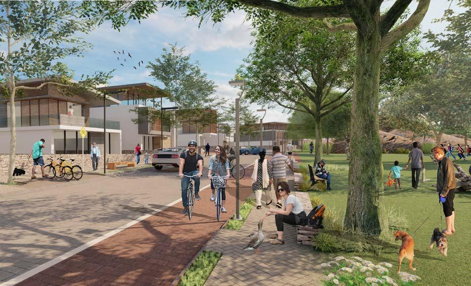
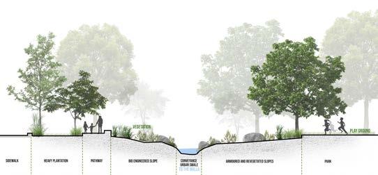
Given the concern for environment and especially water, rainwater conveyance has been the generator of streetscape and lowimpact infrastructure design.
Lid or eco-streets are designed favouring soft engineering and vegetated treatment to manage rainfall conveyance instead of conventional concretized piped system that uses curbs and gutters.
The intent is to capture the rain as and where it falls and reduces the runoff before it enters the trunk lines.The excess water from the lid street is conveyed Using surface flow to the bio-swales.
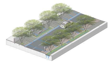
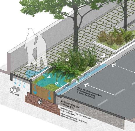
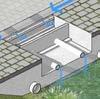
41 page streetscapes INFILTERATION TRENCH
Rain Water Infilteration Trench
Cup Drain Channel Grass Pavers
The park is located centrally to the west-end green park district. It has the north swale linear park running along one side and peripheral access roads along the other sides. It acts as a green wooded edge, a relief place from the built environment. The park offers multi-activities and also passive recreation zones. It has pedestrian links across, connecting the farthest peripheral points.
42 page bio swale
PARK EDGE
LAKE
CLUB
EDGE
SOUTH GREENWAY PARK
PARK
EDGE
CORRIDOR
RAVINE
BIO SWALE
SEASONAL
SOUTH BIO-SWALE
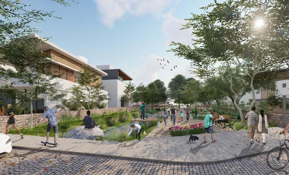

The open space system is designed to manage rainfall conveyance instead of the conventional ‘concretized system’
This gently sloping multi-layered ecological device detains, cleans & filters, and infiltrates part of the run-off before releasing it into the proposed pond at the western end of the clubhouse as well as the rivulet at the edge of the site.
The bio-swales or greenways not only act as water channels but also become a haven for nature oriented uninterrupted outdoor walk trails, bikeways, and lead the residents to the forest at the western edge.
43 page
Rain Water Infiltration Trench
CORRIDOR EDGE
Rain Water Chamber Outflow Cup Drain Channel Bio-Swale open space swale system
local farmers
Ecological
local food market green space water management habitat creation
economic
social
urban-rural communication nutrition education youth program
Agricultural sector plays a strategic role in the process of economic development of a country. The agricultural land has continued to shrink due to rapid urbanization. Urbanisation results in transformation of land-use, environment and culture of communities, specifically, in the interface, thereby, altering the city-region’s ecology.
The interface is the territory of urbanising villages with different intensities and different scales of urbanisation. The process leads to the formation of ‘urban villages’, which, more than often turns into back drop of the city/slums?
WEAVING AGRICULTURE INTO
URBAN LAND-USE
CENTER FOR FOOD AND AGRICULTURE
Urbanisation is inevitable. And in the process of development the farmers are neglected and their source of income is lost. Both peri-urban and urban agriculture contribute to a regional dynamic that connects urban and rural residents in the pursuit of a sustainable food ethic.
Farmers markets connect people to local farmers, creating a sense of community between rural and urban.
The proposed Center for Sustainable Food and Agriculture envisions a place where researchers, farmers and the community work for the economic, social, and ecological benefits of a regional food system
Location: Raj Nagar Extension, Ghaziabad, Uttar Pradesh
Institution / Mixed Use Development
Guide: Manas Murthy
4th Year THESIS | 2016 Academic | Individual
44 page
Chakkarpur village is a high density village with an approximate population of 16500 and an area of 34 ha., completely surrounded by diverse residential colonies and has no connection with the external city.
Jharsa village has an approximate population of 2500 and an area of 5.7 ha. and it acts as one of the link between planned residential neighborhoods around it and the main sector road. Most of the people, pass through the central street of village to go into surrounding residence
At its interface:
Small, low cost residence has positive interface with the village and use the shops in it. High end residence on the other hand make boundary walls to cut of access to the village.
At its interface:
The central spine of the village is used by surrounding residence, it gives an opportunity to the village to cater to the needs of surrounding neighborhoods. A lot of grocery & other utility stores can be seen on the main street of the village
Sukhrali village has a population of 10,000 living in an area of 30 ha. Unlike any other village in Gurgaon, Sukhrali village has a major arterial road passing through it. The village is therefore well connected with the whole city and caters to the need of the whole city.
current scenarios of urbanism story of the villages near us
At its inter face:
There is destination market at the ground level with commercial floors over it. People from all over the city come to Sukhrali as it has variety of shops. Inside the village, there are lots of paying guest accommodations because of the good connectivity with the nearby IT hub.
45 page
Case A : Chakkarpur Village
Case B : Jharsa Village
Case C : Sukhrali Village
The urban villages of developed cities were studied to understand their transformation over the years and problems faced by the people. This led me to select my site in per-urban area that is still under the process of urbanisation.
The site is located on the exterior of the town Ghaziabad. The Fertile Agriculture land is being converted to different land uses at a fast pace.
Ghaziabad has a strong foundation for food and agriculture awareness and hence makes for a fitting place to research Sustainable Metropolitan Urban Agriculture
The nature of metropolitan region agriculture can be planned or opportunistic, scattered or cohesive. Planning large tracts of land designated for agricultural use, as in the peri-urban farms surrounding Ghaziabad’s urban growth boundary, creates opportunities for large scale production in close proximity to the city, supporting a local economy with a strong rural-urban relationship in food production and consumption.
The even closer relationship of agriculture within dense urban environments creates the opportunity for a different scale of relationship: neighbor to neighbor, garden to restaurant, student to learning garden.
46 page
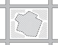
farm lands farm lands urban village urban village extensionhighwtay Roof garden alley garden community garden urban growth boundary regional view site response pedestrian movement vehicular movement context plan
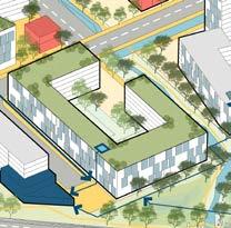
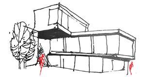
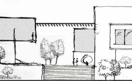
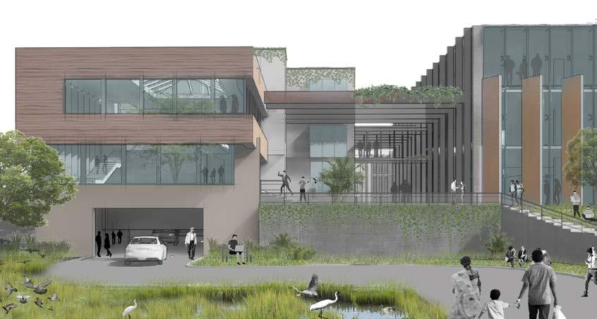
Integrated Green Spaces:The building directs its users out into nature in order to get to other offices or parts of the structure. The gardens act as an informal meeting space for researchers and consists of test beds.
Massing:The building was designed not to dominate its rural setting, but to embrace the landscape, with all workplaces in direct contact with indoor and outdoor gardens.
Create a U-Shaped buildings that will frame indoor and outdoor farming areas, as well as retail spaces and distribution facilities.
• Market square where farmers can sell fresh produce;
• A farming demonstration area and accompanying classrooms;
• A kitchen incubator for startup catering and wholesale food businesses;
• A library
• Retail area for food trucks.
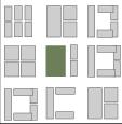
1. Entrance Podium Reception, entrance to the library and a viewing deck for the common growing space
An informal meeting areas for the researchers.
3. Institutional Block Entrance 1
4. Library Block
An auditorium with a capacity of 300
6. Covered Growing Space
A growing garden to test plants in a controlled environment
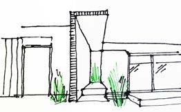
7. Green Pockets small growing spaces directly connected to the working areas
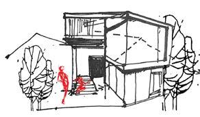
8. Parking Entry exploring the form
9. Parking space for food trucks and spill out zone for the market
47 page
5. Auditorium
2. Common Growing space
Visible from the entrance 1 9 2 3 4 5 6 7 8
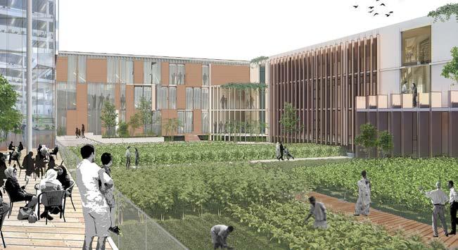
By providing outdoor educational and social spaces for visitors and the public, the plan simultaneously improves the local ecology, creates a campus identity, strengthens connectivity, and extends the campus’s growing conservation work in the region.
Farmer’s markets connect people to local farmers, creating a sense of community between rural and urban.
The proposed Center for Sustainable Food and Agriculture envisions a place where researchers, farmers and the community work for the economic, social, and ecological benefits of a regional food system.
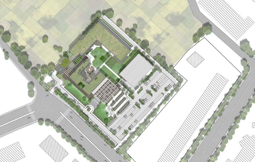
48 page library drop-off offices complex extended entrance extensionHIGHWAY growng area growing area auditorium amphitheater market area
proposal
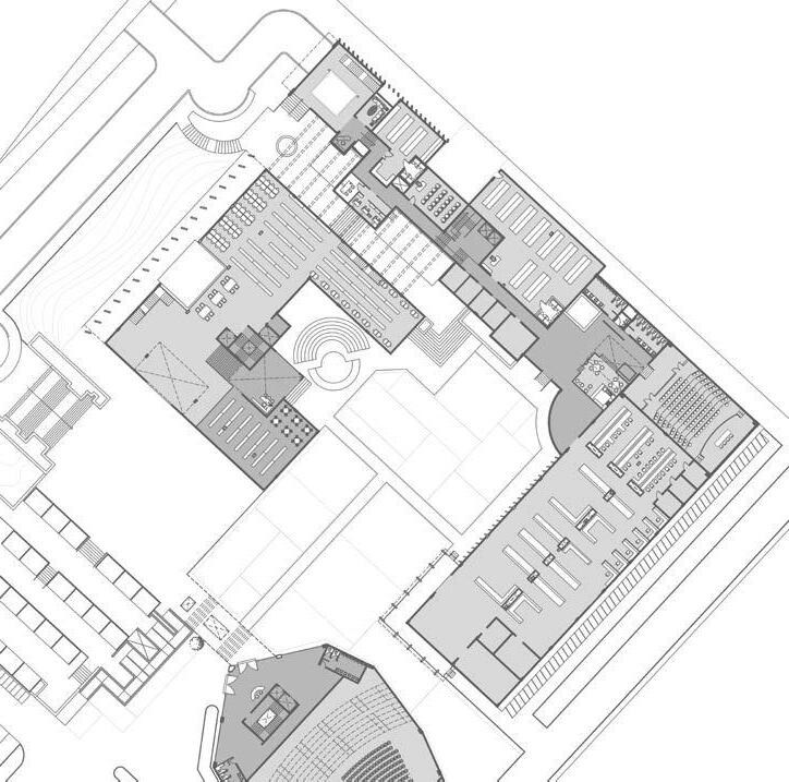
ground floor plan
1 . Reception
2 . Public Library
3 . Amphitheater
4 . Central Growing Space
5 . Institutional Wing
6 . Admin Block
7 . Green PocketsControlled growing areas
8 . Lecture Rooms
9 . Laboratory
10. Auditorium
49 page proposal 2 1 3 4 5 6 8 8 9 10 7