WE WILL MEASURE SUCCESS:
• Minimize loss of wetland areas
• Improve wetland conditions
• Increase protected and restored wetland acres/sites
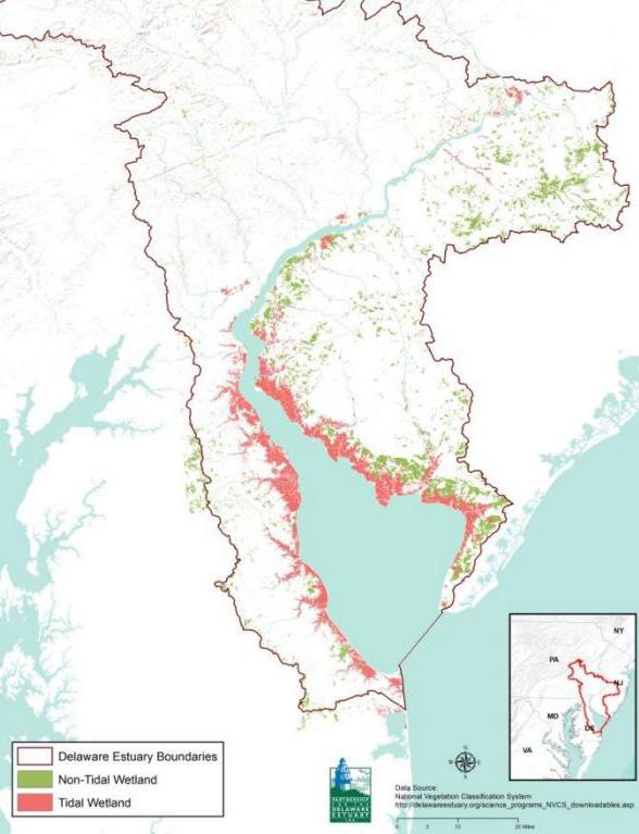
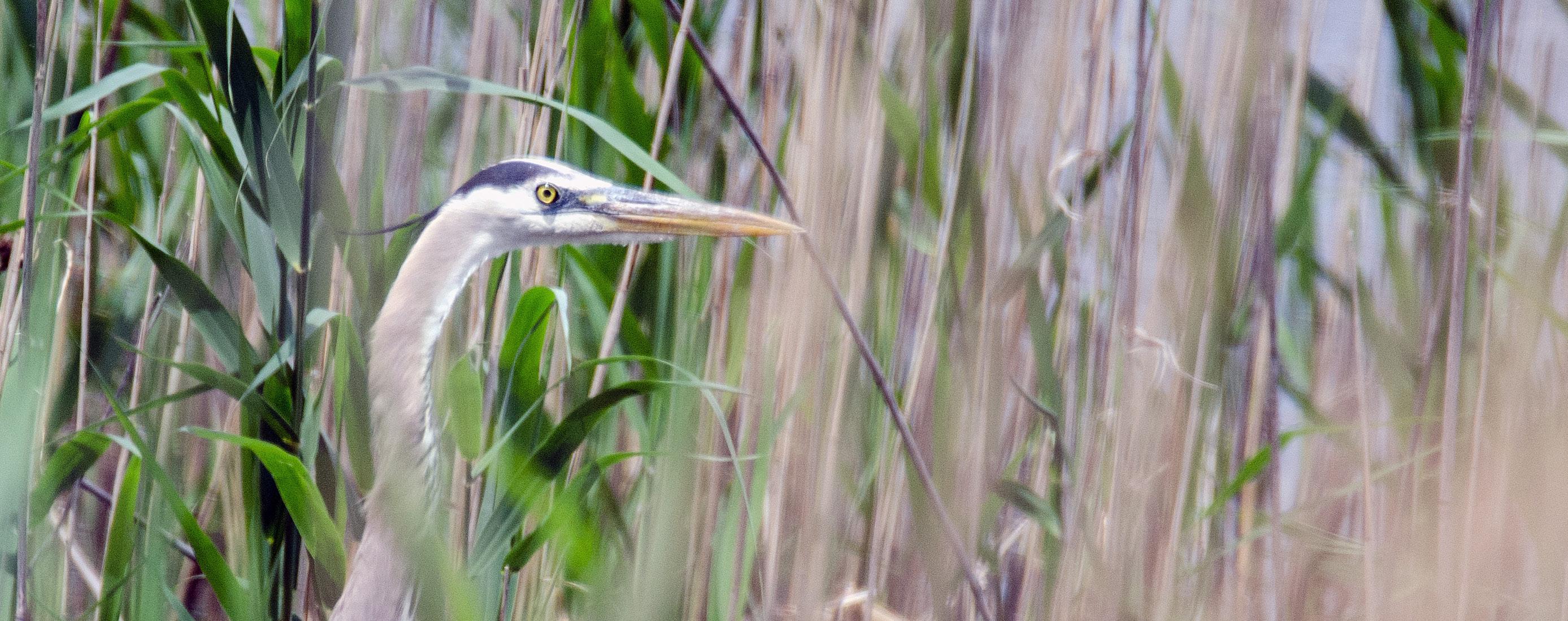
Tidal wetlands are some of the most productive habitats in the world, and arguably the most ecologically and economically important type of natural habitat in the entire Delaware River Basin. Current trends suggest that tidal wetlands, particularly salt marshes, and hence the ecosystem services and the direct financial and aesthetic benefits they provide, are being degraded and lost throughout all areas of the Delaware Estuary. Thus, a recommitment to wetland protection and finding new, creative ways to manage and sustain wetlands and their health is warranted. Expanded outreach to the public and decision-making elected officials also is required to build awareness of wetlands’ critical benefits and vulnerability.
STRATEGY H1.1: Establish clear baselines for tidal wetland conditions and track changes over time
Description
Tidal wetlands, also referred to as coastal wetlands, are at high risk of degradation because of human disturbance, rising sea levels, and climate changes. They provide such services as flood abatement, storm surge attenuation, nutrient sequestration (in addition to other coastal habitats, including dunes and maritime forests). Further, tidal wetlands play a key role in the life cycle of many commercially important fisheries. These services make these habitats a high priority for inventorying and studying current conditions, as well as the way they are changing over time.
Considering tidal wetlands’ importance, it is vital to track changes in their acreage and health over time. In Delaware, rapid assessment studies of tidal wetland conditions have been carried out for all the watersheds along Delaware Bay, and a comprehensive inventory of statewide wetland acreage is planned during 2018. It is vital to establish baseline conditions
where they currently do not exist. Areas that are changing rapidly, such as in the urban corridor, warrant periodic resurveys of tidal wetland conditions, and their extent overall should be monitored carefully over time. These data feed directly into loss intervention planning by prioritizing
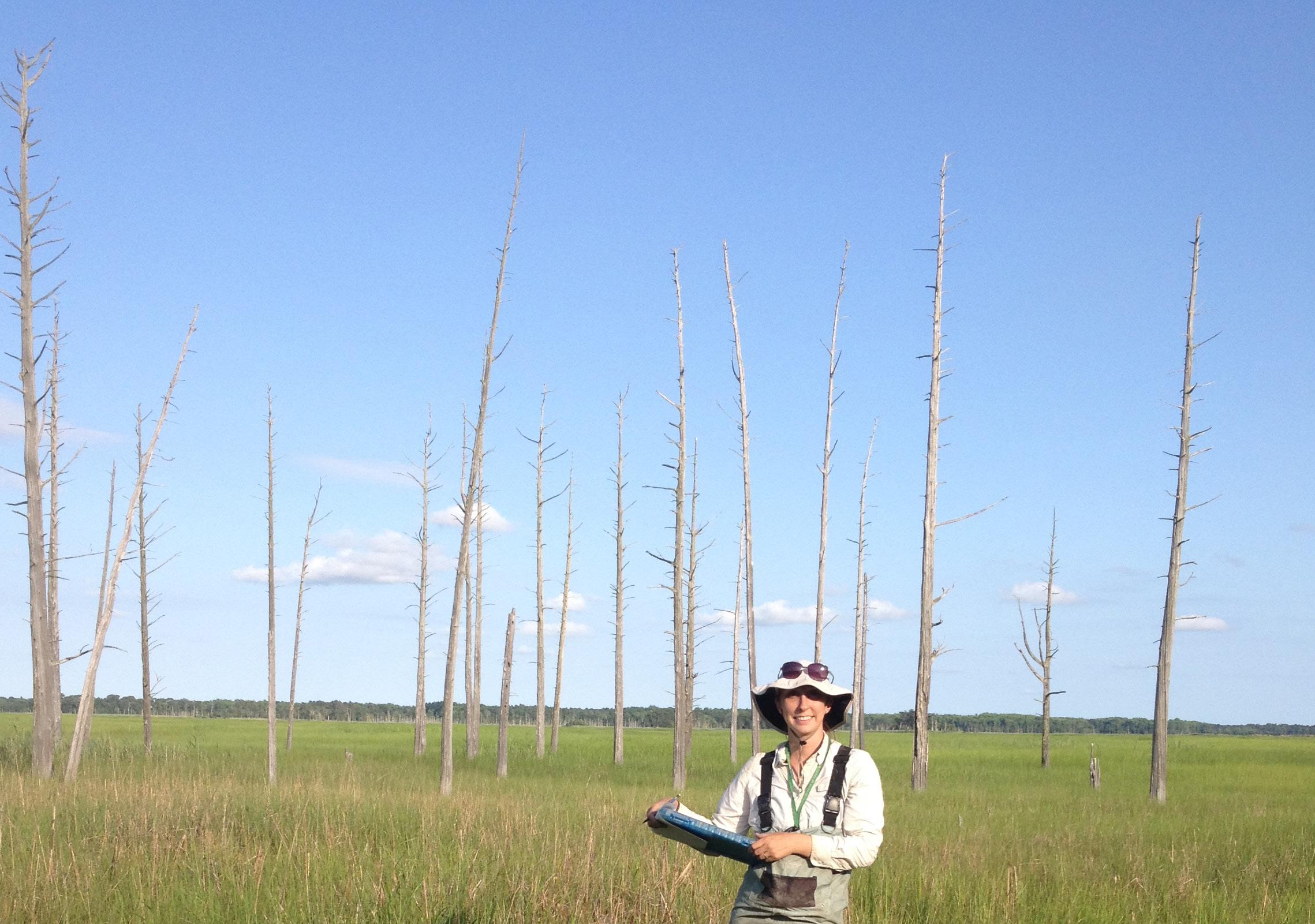
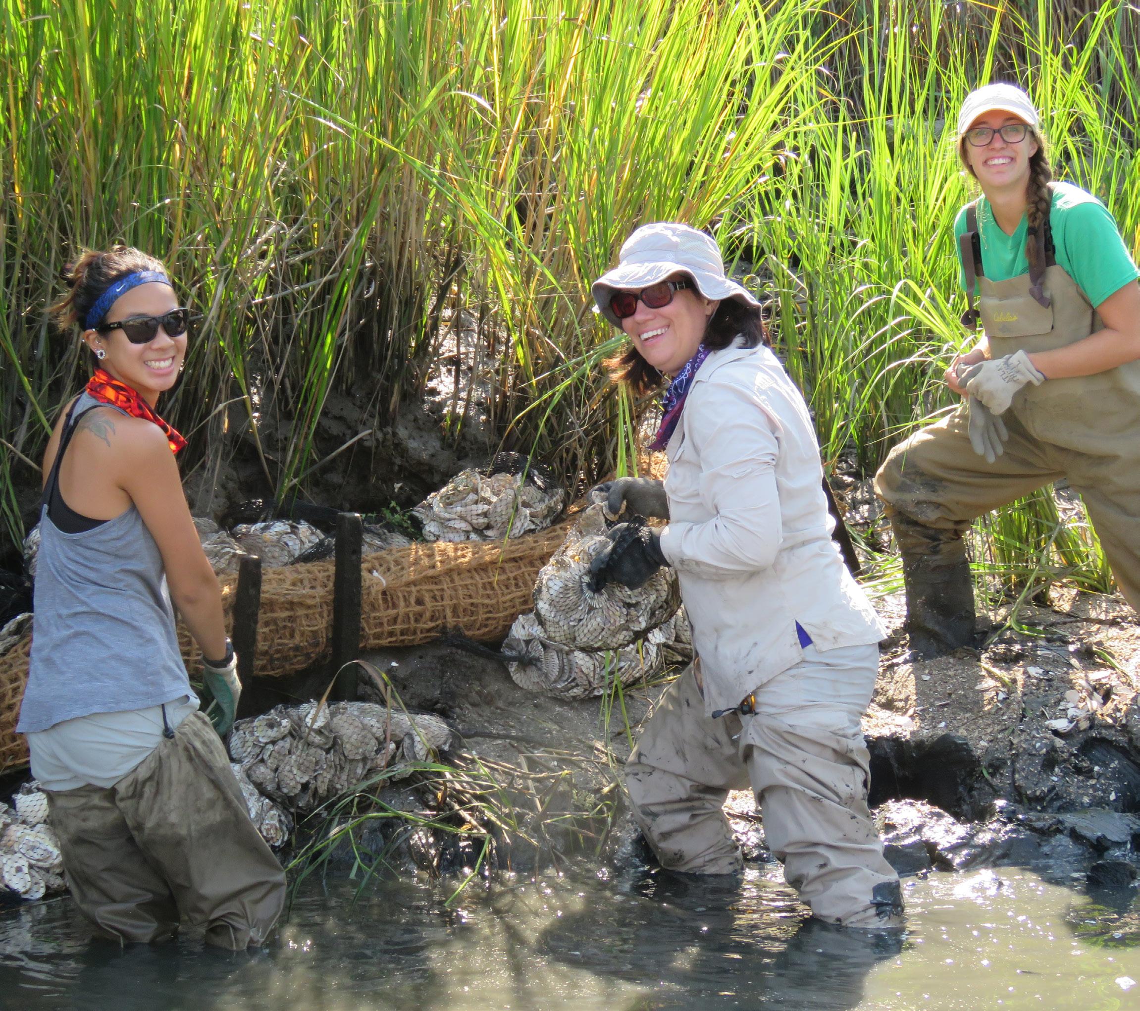
PDE Site Specific Intensive Monitoring (SSIM) of wetlands along Dennis Creek, NJ with the Barnegat Bay Partnership. | Credit: PDE
specific coastal wetlands that either are at risk most or have the highest ecological service value.
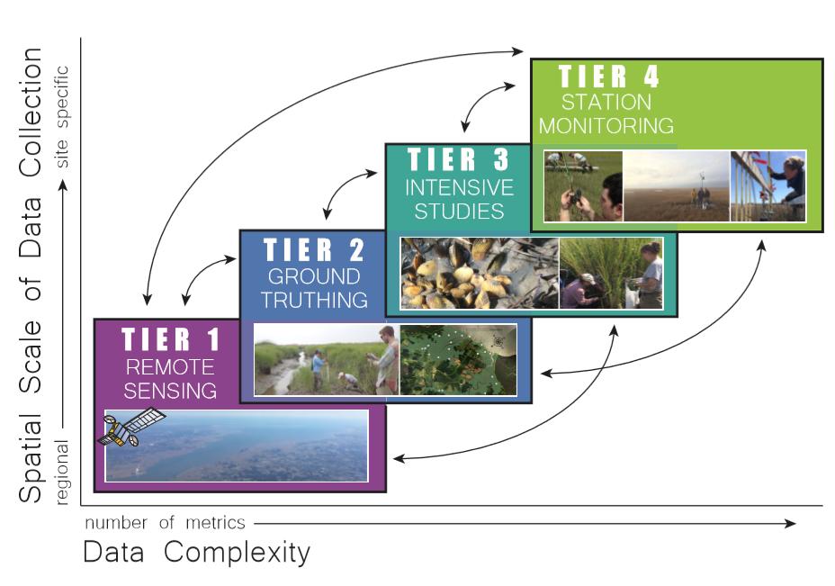
The Mid-Atlantic Coastal Wetland Assessment (MACWA) was established in 2006 as a way to provide a consistent, robust way to accumulate multi-agency data on mid-Atlantic coastal wetland conditions and geographic extent. State and federal agencies, and academic and non-profit organizations collaborate on MACWA, which PDE coordinates within the Delaware Estuary study area. In addition to tracking tidal wetland acreage and conditions, program partners also conduct research on coastal wetland dynamics, study causes of wetland degradation, and work to promote awareness about the tidal wetlands’ importance. The MACWA program has four tiers that support landscape-level remote sensing data (Tier 1), rapid ground assessments across large areas (Tier 2), intensive studies to examine ecosystem relations and cases of degradation (Tier 3), and long-term monitoring at permanent stations (Tier 4).
Since 2006, seven long-term monitoring stations have been installed in The Delaware Estuary under MACWA’s auspices, and more than 400 wetland sites’ health has been assessed. To provide a regional context within
which to interpret findings, additional MACWA surveys and monitoring stations exist outside the Delaware Estuary focus area. State agencies also maintain wetland management plans and inventories for regulatory and conservation purposes that are complimentary to MACWA. As the 2017 Technical Report for the Delaware Estuary and Basin discussed, results from
The 4-Tier approach to the Mid-Atlantic Coastal Wetlands Assessment (MACWA). | Credit: PDE
MACWA and other monitoring efforts show that a diverse array of stressors are affecting tidal wetlands, which vary widely among different watersheds of the region. Large areas remain unsurveyed, so more data are needed. These data are vital to identify and design costeffective intervention tactics that can be used to stem coastal wetland habitat loss.
The techniques, policies, and plans used to prevent coastal wetland loss and restore degraded areas rely heavily on the continued collection of high-quality scientific data and translation of their findings for coastal resource managers, restoration practitioners, and the public. As MACWA serves as an important data repository, it is integral that this (and other related) wetland programs are sustained and expanded as the need for these data increases.
The major components of this strategy are:
y Sustain and grow MACWA. MACWA, and synergistic state-based programs, can be supported by continuing annual monitoring at least every 10 years at long-term stations, completing rapid assessments in watersheds that have not yet been assessed to develop a comprehensive baseline, and repeating rapid assessments in watersheds where changes are occurring more quickly.
to rising sea levels and other stressors, and prioritize coastal wetland areas for planning and management.
y Use monitoring data that MACWA gathers and maintains. Monitoring data can be used to identify areas that are most vulnerable
y Provide restoration recommendations. Recommendations can be used to guide the design and management of various restoration or intervention projects that alleviate site-specific stressors best, and provide a monitoring framework to gauge success.
PDE conducts rapid wetlands assessments on the Maurice River in NJ. | Credit: PDE
y Conduct research. Conduct research to answer key questions regarding mechanisms of tidal wetland loss to guide management and restoration.
y Develop State of the Wetlands reports. Synthesize data from MACWA’s four tiers and complimentary state wetland programs to develop State of the Wetlands reports every 5 years for use in subsequent State of the Estuary Reports.
y Conduct outreach. Perform outreach to elected officials and the public to foster awareness of tidal wetland status and trends, highlighting the ecological and economic importance of proactive wetland management and monitoring. The primary constraint affecting this strategy’s success is lack of dedicated funding. Sustaining and increasing wetland monitoring programs such as MACWA has relied thus far on short-term grants and partners’ in-kind contributions. A primary purpose of this strategy is to collect and synthesize data to understand coastal wetland processes better, especially as those processes react to external stressors such as storms, rising sea levels, eutrophication, toxins, climate change (precipitation or temperatures), and anthropogenic disturbance. Climate change certainly will affect tidal wetland function and potentially the ability to collect data at long-term stations. Monitoring wetlands and surveying conditions requires continued investment in both time and money. Political climates, private-sector interests, governmental funding (state and federal) available overall, and partner
organizations’ capacity can pose threats to this strategy’s success overall.
Performance Measures and Key Deliverables
y Complete baseline rapid condition assessments (e.g., Mid-Atlantic Tidal Wetland Rapid Assessment Method) for all watersheds adjoining the Delaware Estuary by 2025.
y Maintain landscape-level inventory maps (e.g., National Wetland Inventory) no more than 10 years old for all watersheds adjoining the Delaware Estuary.
y Repeat rapid condition assessments in rapidlychanging watersheds (e.g., urban areas) every 10 years.
y Produce one research report or product annually and an integrated report every five years to identify wetland stressors, translate outcomes, and guide tidal wetland management and restoration, respectively.
y Track monitoring and research on tidal wetlands within the Delaware Estuary focus area and vicinity.
Costs and Funding
y Estimated Cost Range: $$$ - $$$$
y Possible Funding Sources: Agency operating funds, federal, state, and private grants
Purpose
To develop robust scientific datasets on coastal wetland conditions to understand and manage their change over time.
Core Partners Partnership for the Delaware Estuary, States (DE, NJ, PA)
Key Partners
Academia, The Nature Conservancy, United States Fish and Wildlife Service
Contributing Partners
Barnegat Bay Partnership, South Jersey Bayshore Coalition Timeframe
Ongoing, with 11 stations monitored annually and a minimum of 60 rapid assessments annually for completion of baseline by 2025
STRATEGY
H1.2: Restore, enhance, and manage tidal wetlands for maximum health and resilience
Description
The Delaware Estuary is bordered by approximately 165,000 acres of coastal, tidally-influenced wetlands that constitute the hallmark landscape of the Delaware Bay. These tidal wetlands also serve as habitat for unique plants and animals, while also providing critical services to our economy, health, safety, and way of life.
Tidal wetlands in the Delaware Estuary continue to be lost and degraded through anthropogenic and natural causes that threaten these habitats’ health, function, resilience, and future.
This strategy focuses on stemming the loss of tidal wetland acreage, achieving a net increase in protected tidal wetlands’ extent, and improving their health and function through restoration, enhancement, and strategic management efforts.
An example of a tactic that may stem the loss of tidal wetlands in areas threatened by rising sea levels is the beneficial reuse of dredged sediments that are placed
Installation of a living shoreline along the Nantuxant Creek in NJ. | Credit: PDE
on vulnerable areas of the wetland platform (e.g., by thin-layer spraying). This emerging approach is similar to traditional beach replenishment, and likely will need to be repeated periodically according to rising sea levels. In addition to the potential ecological benefit, this approach could be costeffective in some areas by reducing costs of dredged material disposal, as suggested in the 2013 Regional Sediment Management Plan for the Delaware Estuary.
Delaware and New Jersey recently have begun to test thin-layer placement of dredged sediments in pilot wetland areas. Although this tactic may prove to be beneficial for some tidal wetlands, the 2017 Technical Report for the Delaware Estuary and Basin indicates that this approach to elevate the marsh platform does not address the greatest vulnerability in most areas, lateral erosion. Scientific concerns also have been raised about site selection, placement method, and type and depth of sediments placed. Therefore, beneficial sediment projects and any other new tactics designed to enhance tidal marsh conditions or acreage require further research, monitoring, and standards development to assist with permitting decisions and restoration project designs. Once a new practice is proven viable and beneficial to tidal wetlands, it also is necessary to train restoration practitioners properly and educate landowners about their restoration options.
Key activities include:
y Use MACWA data for protection and restoration. Use MACWA data to identify high-value wetland protection and restoration opportunities and strategies, evaluate results (marsh futures, monitoring protocols), and bolster the amount of useful monitoring data by coordinating methodologies and compiling results from multiple sources.
y Use traditional practices. Study and integrate traditional practices for ongoing efforts such as mosquito management and Phragmites
eradication, and coastal impoundment restoration in ways that increase health and resiliency.
y Conduct Research. Use research to develop and evaluate new practices (e.g., thin layer placement, living shorelines) and ecosystem service valuation to inform/improve restoration and management while considering climate change effects.
y Apply RSMP recommendations. Implement key RSMP recommendations (e.g., beneficial use of sediment).
y Protect and restore tidal wetlands’ natural buffers. Work with partners to identify areas where tidal wetlands will migrate and help develop a plan to conserve these areas to allow natural migration
y Promote water quality improvements. Continue to promote and develop new strategies to improve water quality using shellfish (e.g., oysters, ribbed mussels, freshwater mussels).
Changes in climate likely will bring the Estuary warmer summers and winters, rising sea levels, increased storms and droughts, and salinity variations, all of which may disrupt wetlands restoration, enhancement, and management. The strategy to maximize wetland health and resiliency may still be attainable if adjustments are made, but climate change effects may be extensive throughout the watershed, and either are occurring already, or will in the next 10 years. Shifts could occur in community species composition, and flow and salt lines could be altered. An increase in the number of violent storms may harm wetlands, making restoration more difficult. Further, rising sea levels will compromise wetland health and make managing them more difficult.
Performance Measures and Key Deliverables
y Use MACWA data and mapping tools to identify and implement five pilot projects by 2022 to restore or avert the loss of 100 acres in different
tributary watersheds along the Estuary’s salinity gradient.
y Produce one research or monitoring report annually to guide successful implementation of nature-based tactics.
y Use research and monitoring to identify ways to increase wetland health and resiliency via practices such as Phragmites, mosquito, hydrology, and buffer management.
y Track restoration, management, research project numbers, and results on tidal wetlands.
Costs and Funding
y Estimated Cost Range: $$$ - $$$$
y Possible Funding Sources: Environmental Protection Agency Regional Applied Research Effort grants, U.S. Army Corps of Engineers, National Oceanic Atmospheric Administration Office of Response and Restoration, National Fish and Wildlife Foundation, Wetland Program Development Grants, Natural Resources Conservation Service
Purpose
Increase tidal wetlands’ acreage, condition, and resilience through habitat protection, restoration, and enhancement. Core Partners
Partnership for the Delaware Estuary, States (DE, NJ, PA)
Key Partners
Delaware Nature Society, National Fish and Wildlife Foundation, The Nature Conservancy, United States Fish and Wildlife Service, Local municipalities and NonGovernmental Organization partners
Timeframe
Ongoing
St. Jones River, Bowers Beach, DE | Credit: Leigh Schuck
STRATEGY
H1.3: Develop and implement natural and nature-based techniques to stabilize and restore eroding shorelines, and to build and protect wetlands, infrastructure, and other key resources
Description
More than 100 acres of tidal wetland in the Delaware Estuary are lost annually,11 and the future net loss is expected to reach nearly 119,000 acres by 21006,8. Most of the current loss is occurring because of shoreline erosion and increased inundation. Natural and nature-based infrastructure can be used to stabilize and restore eroding wetland shorelines and build and protect wetlands.
Implementation of natural and naturebased infrastructure requires methods to identify site-specific vulnerabilities and match them with appropriate intervention techniques, including living shorelines or thin layer sediment placement (see “beneficial use of sediment” in previous strategy). Tools, such as PDE’s Marsh Futures, allow physical and biological data to be integrated over time and space,
while programs such as the MACWA serve as relative measures against which site-specific marsh health can be evaluated. Innovative tools and methods like these that key partners are adopting currently will help minimize wetland loss by facilitating the identification and prioritization of intervention needs throughout the Estuary.
Living shorelines include diverse types of shoreline stabilization and enhancement tactics. They differ from traditional approaches, such as use of bulkheads and rip rap, by promoting some stabilization because of healthy ecological communities’ resilient properties. Interest in living shoreline approaches has grown rapidly in the past 10 years, and PDE and academic partners, such as Rutgers University, have been at the forefront of this effort by designing and implementing the Delaware Estuary Living Shoreline Initiative (DELSI). This initiative includes efforts to: 1) research and develop new nature-based tactics that are appropriate for the system’s unique ecology; 2) develop science-based tools to prioritize areas for treatment and choose the methods that match site-specific goals and ecological conditions; 3) coordinate diverse groups via leadership on technical work groups; 4) promote technology transfer to the private sector; 5) manage

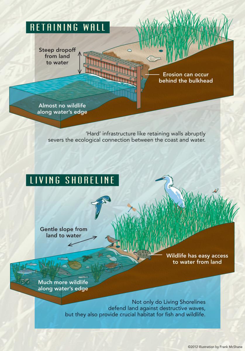
Graphics from PDE’s Living Shorelines: Healthy Shores, Healthy Communities publication, showing how living shorelines are different from a traditional retaining wall.
projects adaptively using monitoring data both scientists and the public collect, and 6) perform outreach about living shorelines to educate the public, private landowners, and elected officials.
By using natural and nature-based tactics, native plants and animals’ ecological benefits also can contribute to water quality and biological diversity. Target species for DELSI projects typically include dominant wetland vegetation and bivalve shellfish. Species selected for use in living shorelines must be appropriate for the specific site, because the Delaware Estuary varies widely in salinity from fresh to saltwater. Shellfish, ranging from freshwater mussels to saltwater oysters and ribbed mussels, usually are paired with vascular plants because scientists consider them ecological engineers that enrich plants, finfish, birds, and other wildlife’s habitat quality when abundant.
Interest in nature-based restoration approaches has been growing rapidly throughout the United States, especially with respect to living shorelines approaches. As evidence, the US. Army Corp of Engineers adopted a first-ever Nationwide Living Shoreline permit recently. In the Delaware Estuary, Delaware and New Jersey also have modified their permit rules to accommodate many types of living shoreline approaches more easily. In 2013, the State of Delaware created a Delaware Living Shoreline Committee, which has worked closely with PDE and dozens of other partners to promote awareness, train contractors, assist with permitting, and share scientific outcomes related to living shorelines. Similar collaborative efforts have been coalescing in New Jersey, especially in the wake of Hurricane Sandy, which spurred greater interest in coastal wetlands’ protective value.
To help stem wetland loss, natural and nature-based infrastructure will be used to stabilize and restore eroding wetland shorelines and build and protect wetlands through the following key activities:
y Identify, implement, and use demonstration projects that show natural and nature-based approaches. Use these sites and
experiences to promote local awareness of non-traditional methods of shoreline management among landowners and contractors and provide study opportunities to quantify long-term ecological benefits and maintenance costs. Taking an active role in demonstrating nature-based approaches’ effectiveness, such as the numerous ways living shorelines can be used rather than traditional techniques (e.g., bulkheads), is needed to change current thinking and practice, and generate data on costs and effects to show homeowners and contractors alternate options. Ideally, there will be demonstration sites accessible to communities for every major living shoreline type developed, including urban freshwater hybrid designs under development currently.
y Use new restoration tactics to stem shoreline erosion, including combinations of tactics and large-scale natural and nature-based projects. Projects could include living shorelines, as well as hybrid approaches that pair innovative, nature-based principles with traditional methods. To date, most projects have been modest in size, but making a significant difference in wetland loss requires expanding these tactics to landscape-scale. A large-scale project’s goal is to address shoreline erosion holistically over a larger area, such as the mouth of a river, or an extended stretch of shoreline protecting an important area of habitat or community resources. This could be a single project (such as an offshore living shoreline that extends for a mile or more and protects a contiguous stretch of beach or marsh), or a combination of many projects/tactics designed to work together (such as the combination of approaches that has been proposed to stabilize the mouth of the Maurice River).
y Develop, apply, and standardize new science-based tools and approaches (e.g., marsh futures, water resources research). Science-based tools and approaches can be used to prioritize, monitor, and manage tidal wetland restoration projects adaptively, such as living shorelines, thereby promoting greater success and ability to track outcomes. These include monitoring approaches to gauge natural
and nature-based projects’ outcomes, as well as decision-making tools to guide the selection of appropriate project sites, tactics, monitoring, and adaptive management based on local vulnerability and conditions. Decisions important to selecting sites and techniques should consider not only the positive effects on tidal wetlands, but also benefits in protecting community infrastructure (e.g., roads and access points) as well as benefits to other important key resources (e.g., fish, shellfish). New tools and approaches also can be shared as they become common practice.
y Sustain and enhance collaboration. Collaboration among state and federal agencies, non-profits, academic organizations, restoration practitioners, and regional watershed groups is used to advance science and the use of tools and tactics. Partner collaboration supports efforts to identify and prioritize tidal marshes that require protection or restoration, use science-based tools to choose appropriate tactics that are matched with site-specific ecological needs, and develop managers’ decision support tools for regulatory and permitting decisions.
PDE will play a leading role in undertaking these activities in partnership with Rutgers University, the Nature Conservancy, private businesses, and state and federal agencies that manage wetlands and shellfish.
Rising seasonal temperatures, storm frequency and magnitude, salinity, and sea levels across the Estuary are expected to affect natural habitats’ health and distribution, especially tidal wetlands. Efforts to
facilitate natural and nature-based infrastructure projects will need to account for changes in these environmental factors. Targets chosen should be sustainable, and adaptive management of sites and specific projects will be vital.
Performance Measures and Key Deliverables
y Produce at least one new report, guidance product, or training annually to share research and development of new and innovative nature-based tactics and decision support tools to sustain, enhance, or restore tidal wetlands. Implement 5 new living shoreline projects spanning the salinity gradient over 10 years, including at least one large-scale project.
y Produce one monitoring report annually to assess and translate outcomes from at least one living shoreline project.
y Track the number and results of restoration projects that use nature-based methods such as, but not limited to, living shorelines.
Costs and Funding
y Estimated Cost Range: $$$ - $$$$
y Possible Funding Sources: State, federal, foundation and corporate grants, (319, Coastal Zone Management, State Revolving Fund, Sea Grant, U.S. Environmental Protection Agency Wetland Program Development Grants, Flying Fish, Geraldine R. Dodge Foundation, Welfare Foundation)
Purpose
To prevent wetland loss and promote ecological resilience through the targeted application of appropriate natural and nature-based infrastructure.
Core Partners
Partnership for the Delaware Estuary, Philadelphia Water Department, States (DE, NJ, PA), United States Environmental Protection Agency
Key Partners
Local municipalities and NonGovernmental Organization partners, National Fish and Wildlife Foundation, National Oceanic and Atmospheric Administration, Rutgers University, The Nature Conservancy, United States Army Corps of Engineers, United States Fish and Wildlife Service
Contributing Partners Academia
Timeframe
Preventing wetland loss is an ongoing priority contingent on resources. Living shoreline projects typically take 2-3 years to implement, with monitoring and periodic maintenance thereafter. At least one project newly completed annually is expected
STRATEGY H1.4:
Protect, enhance, and improve non-tidal wetlands
Description
The Delaware Estuary is fed by an extensive network of tributaries that connect the upper reaches of every watershed together to the Delaware River and Bay. Those tributaries are flanked and fed by almost 248,000 acres of non-tidal wetlands which serve as headwater filters, forested habitats, floodplain storage units, and biologically-rich isolated wetlands.11
Non-tidal wetlands in the Delaware Estuary continue to face the pressures of direct effects (conversion for agriculture and development) and secondary effects (human encroachment, natural hydrology disruption, contamination from excess nutrients and pollutants, and the effects of rising sea levels
and climate change).
This strategy focuses on minimizing non-tidal wetland areas’ loss, achieving a net increase in their acreage, and improving their health and function through restoration, enhancement, and targeted management approaches. Wetland mitigation projects required by regulatory agencies and the establishment of wetland banks provide additional mechanisms to restore and enhance wetlands.
Key activities include:
y Protect high-value wetlands. These wetlands can be protected through land acquisition, conservation easements, or other methods identified. Use combined mapping resources to prioritize areas for restoration or protection.
y Use ecosystem service and natural capital values to educate and motivate stewardship. Acquire more
Tidal and non-tidal wetlands in the Delaware Estuary Focus Area (See Living Shorelines in the Delaware Estuary: Best Practices from Lessons Learned and Information Collected by the Partnership for the Delaware Estuary and the Rutgers Haskin Shellfish Research Laboratory, 2008 – 2012 for more information).
accurate, local, and current valuation figures for non-tidal wetland functions.
y Support voluntary stewardship. Promote voluntary stewardship practices that focus on non-tidal wetlands.
y Provide outreach. Increase efforts to educate, share information through outreach programs, and transfer technologies.
y Promote restoration and protection. Collaborate with other organizations to promote and increase non-tidal wetland and stream restoration and protection.
y Improve habitat. Enhance efforts to improve habitats of key indicator species, such as freshwater mussels.
y Involve stakeholders. Promote establishment of wetland banks that meet non-tidal wetlands’ performance standards and provide ecological uplift by involving local stakeholders and existing state programs.
y Support stewardship for buffers. Protect, restore, and promote stewardship of natural or forested buffers adjacent to non-tidal wetlands.
External constraints that may affect the success of this strategy include differing levels of regulatory protection for non-tidal wetlands among the states (DE, NJ, PA) and federal government, which may require different actions/approaches in different places. Funding limitations and federal cutbacks to the programs that support implementation of freshwater wetland protection and restoration also would affect success.
Protecting non-tidal wetlands is still an attainable strategy provided that adjustments are made, but moderate disruptions are anticipated with climate change, including salinity changes and rising sea levels, which likely will result in salt water intrusion and habitat conversion. Further research is needed on climate change’s effects on non-tidal wetlands.
Performance Measures and Key Deliverables
y Identify, plan, and prioritize high-value nontidal wetlands to protect in each state by 2025
y Increase protection and restoration of nontidal wetlands with at least one successful example in each state annually
y Produce at least one outreach product annually to promote non-tidal wetlands’ stewardship, protection, and restoration
y Track number and results of projects for nontidal wetlands’ restoration and protection
Costs and Funding
y Estimated Cost Range: $$$
y Possible Funding Sources: Federal Farm Bill programs (Wetland Reserve Program)
Purpose
Increase and improve non-tidal wetlands’ acreage, health, and ecological functions through habitat protection, targeted restoration, and focused enhancement.
Core Partners
Partnership for the Delaware Estuary, Philadelphia Water Department, States (DE, NJ, PA), United States Environmental Protection Agency
Key Partners
Local municipalities and NonGovernmental Organization partners, National Fish and Wildlife Foundation, National Oceanic and Atmospheric Administration, Rutgers University, The Nature Conservancy, United States Fish and Wildlife Service, United States Army Corps of Engineers
Contributing Partners
Academia
Timeframe
Ongoing
HEALTHY HABITATS
GOAL 2:
and increase connectivity and resilience of forests for water quality
Description
The Delaware River Basin includes over 6,000 square miles of forest, as well as many forest landowners, and limited resources for forest protection and stewardship. These forests are critical to sustain water quality in the Delaware River and Bay, and thus, assessing and establishing priorities is essential. This is especially true for a NEP, which recognizes the value of forests in the upper Delaware River Basin, but traditionally has worked primarily in the lower Basin. Through State of the Estuary tracking and reporting, there is sufficient basinwide information on forest cover, but little about the conditions needed to prioritize forests for resilience, connectivity, and water resource protection.
The first and most critical element of this strategy is establishing a clear baseline by cataloging forests’ current conditions in the Delaware Estuary’s watershed (the Delaware River Basin) using existing data and researchers and practitioners’ input. The exact methodology to accomplish this has yet to be determined; however, potential options are identified below. In addition to identifying the extent and location of forest cover, this baseline will define and measure:
y Forest Health. Numerous stressors, including high deer populations, invasive plants, insect pests, and climate change, affect forests within the Basin. This criterion will assess cumulative effects and identify forests suffering little to no degradation to prioritize them for protection.
y Forest Loss. Forests face an imminent threat from land conversion, primarily through residential and commercial development, which has accelerated in recent years as the economy improves. This criterion will assess development patterns and ideally identify forests under greatest threat of conversion.
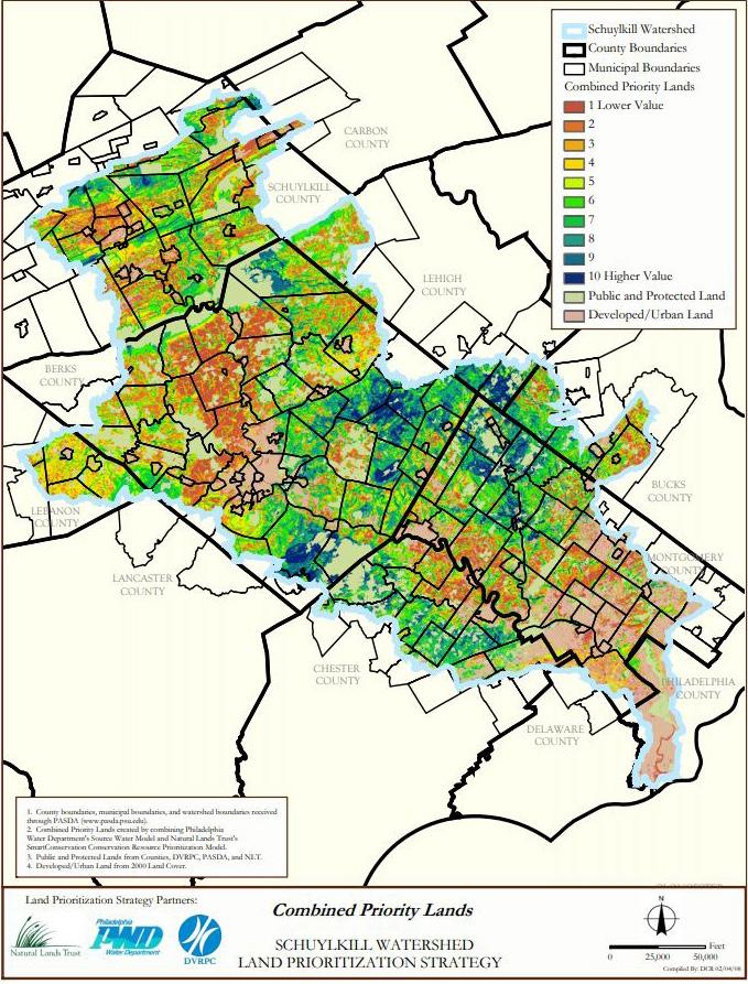
The Schuylkill Priority Lands tool identified and mapped the highest priority lands to protect for water quality, most of which are forested. | Credit: SAN
y Resilience/Connectivity. Forests and their wildlife residents benefit if they are connected to facilitate plant and animal migration. This criterion will evaluate forests’ proximity to each other and ideally identify those with the greatest value for connectivity.
y Water Resource Protection. Forests provide multiple water quality and quantity benefits. This criterion will assess forests’ ability to perform functions, including infiltration, and highlight high-value forests for water resource protection.
Key actions and activities to implement this strategy will include acquiring public information on current forest cover in the Basin, developing and implementing a weighting system for the criterion above, mapping the results, and seeking researchers and practitioners’ input at key stages to test and refine results. Forest health is assessed best on an individual property basis, making this difficult to perform remotely on a large scale. However, this problem might be solved by surveying a select number of sites and extrapolating to a larger area, or using four-color aerial imagery (or other new technology) to analyze key characteristics.
These activities could be undertaken through a collaboration of partners, or one partner or professional engaged as a contractor. The PDE will take the lead to explore these implementation options and work with the partners. Fortunately, there are a number of efforts underway currently in and around the watershed that can inform this work. Some potentially helpful resources include:
w New one-meter resolution land cover data Shippensburg University and the University of Vermont are generating that could be compared to older land cover data to analyze forest loss
w New research on forest resilience by the OSI, The Nature Conservancy, National Wildlife Federation, and the U.S. Department of Agriculture (USDA)
w Data the Academy of Natural Sciences and OSI generate/use to fulfill their respective roles in the Delaware River Watershed Initiative
w Data from other areas/agencies, such as the Chesapeake Conservancy’s Innovation Center and conservation data from NASA
w Prioritization methodologies used in subset areas of the Basin, such as the Hopewell Big Wood Partnership, the SAN Priority Lands, Pinchot Institute for Conservation & Common Waters Partnership, and the DRWI clusters
The United States Geological Survey National Geospatial Program is the Federal Steward for the National Hydrography Dataset (NHD) and the Watershed Boundary Dataset (WBD), and is working on Quality Level 2 digital elevation models derived from lidar in conjunction with the NHD and WBD for updated land cover mapping
Another approach that should be considered is using existing information to assess tipping points for forest losses. The Center for Watershed Protection makes information available on thresholds that indicate when a watershed begins to deteriorate based on a given area’s impervious coverage. OSI also provides information for sub-watersheds in the Delaware River Basin (impervious cover rates, number of protected acres, type of land). By combining the OSI model and the Center for Watershed Protection’s impervious cover model as a baseline, areas approaching a tipping point for water quality could be identified and designated as highpriority areas.
The watershed is home to a number of conservation organizations with long histories and rich experience in forest protection and stewardship, many of which are involved in the efforts above. Each of these organizations offers potential information and/or partnerships that can be explored and used to implement this strategy. In the meantime, a variety of resources can be promoted and used to prioritize forested areas,
including PDE’s Regional Restoration Initiative and The Nature Conservancy’s DRBC Initiative, both of which highlight forested riparian areas’ importance (See the Regional Restoration Initiative Blueprint Report and the Delaware River Basin Conservation Initiative, respectively, for more information).
Once a baseline is established successfully, it will be used to shape next-generation strategies to improve condition-related effects, including connectivity, resilience, and contribution to water resources protection. The major external constraints that could affect this strategy’s success are the quality and comparability of public information over the extensive geography, and PDE’s limited capacity to expand its geography and expertise. To address this constraint, this strategy’s geography should be limited to those areas where data and partners are sufficient for successful implementation, at least in the shortterm. Climate change’s effects could make forest health data obsolete eventually, depending on the current dominant species’ vulnerability, and should be considered when identifying priorities for resilience.
Performance Measures & Key Deliverables
y Inventory baseline forest acreage and conditions for water quality.
y Identify strategies and begin measuring connectivity between forest patches compared to baselines.
y Assess likely changes from baseline in forest acreage and conditions attributable to climate change and other factors, and furnish recommendations to increase resiliency .
y Track baseline products and projects for forests.
Costs and Funding
y Estimated Cost Range: $
y Possible Funding Sources: State and foundation grants (Pennsylvania Department of Conservation and Natural Resources, New Jersey Department of Environmental Protection, William Penn Foundation), Federal Farm Bill programs (Conservation Reserve Enhancement Program)
Purpose
Establishing clear baselines will inform decisions on the allocation of forest protection and stewardship resources, including grant funding and organizational priorities.
Core Partners
Partnership for the Delaware Estuary, States (DE, NJ, PA)
Key Partners
Delaware River Watershed Initiative partners, Schuylkill Action Network, United States Department of Agriculture - Forest Service, United States Fish and Wildlife Service
Contributing Partners
Academia, Pinchot Institute for Conservation & Common Waters Partnership, National Oceanic and Atmospheric Administration, United States Army Corps of Engineers, United States Geological Survey National Geospatial Program
Timeframe
With sufficient resources, the process of establishing a baseline could be accomplished in a year or two. However, building the support and partnerships needed, and using results to inform nextgeneration strategies will require additional time, making this likely to be a 5+ year project, assuming sufficient resources
STRATEGY
H2.2: Promote stewardship practices by local partners for the health and sustainability of forests for water quality Description
Actions to improve existing forests’ health and resilience are critical to prevent future losses and maximize the values they provide, particularly for water quality. Important forests include those along riparian areas, in headwaters, and in contiguous blocks. Forests today are threatened not only by fragmentation and conversion to other land uses (e.g., agriculture, development), but by invasive pests and plants, deer overabundance, lack of regeneration, storm damage, and climate change. Past timber harvesting practices have left some forests degraded and of little economic value. Stands of forest that contain only one type of tree are more vulnerable to disturbances that diminish their ecological function further, but still provide other natural benefits.
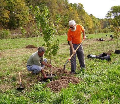
Green Lane Reservoir riparian buffer planting in Montgomery County, PA. | Credit: SAN
Intervention may be necessary, even on protected lands, to help diversify the age and species present in forest tracts, or encourage regeneration where forest cover is inadequate. Improving riparian forests’ connectivity and health is particularly important because of the direct role they play in supporting water quality and regulating flows. Baseflows during summer and drought periods are of particular concern in the Basin, and forest management should be investigated as a strategy to increase groundwater recharge.
The majority of forestland in the Basin’s headwaters areas is owned privately, but the largest tracts of intact forests are under public ownership and management. The fragmentation of ownership makes it more difficult to achieve watershed- or landscape-scale goals. Accordingly, tracking progress on this goal, as well as partnering with state and federal agencies, is critical in implementing this strategy.
Specific activities include:
y Promote forest stewardship and management by adopting and implementing forest stewardship/management plans. To improve forest health, plans can include actions such as thinning, timber stand improvement, invasive species removal, deer fencing or control, pest control, planting, and erosion control on forest roads/trails, etc. Plans also can include strategic reforestation in priority areas, and integrating climate adaptation strategies/recommendations into management activities, which also helps improve professionals’ knowledge base.
y Promote, develop, and implement riparian corridor management plans. Riparian corridor management plans can include buffer planting, vegetation management, and fencing to protect and improve stream corridors and adjacent floodplains and wetlands. Plans also can include restoring streambank and stream habitat to restore natural functions in priority areas, and restoring forested floodplains’ connectivity and functionality.
y Encourage and support research. Research can be used to develop new tactics to increase forest resilience and optimize provision of ecosystem services, including water filtration/infiltration to support adequate baseflows and mitigate heavy precipitation events, especially through the lens of climate change.
y Support continued funding, use, and targeted expansion of cost-share and incentive programs. Current examples of cost-share and incentive programs include those available through the USDA Farm Bill, NRCS Environmental Quality Incentives Program, Conservation Stewardship Program, Conservation Reserve Enhancement Program, etc.), and state farmland and forest assessment and tax relief programs. Both conducting outreach to help people learn about and use these existing programs to complete projects, and exploring opportunities to create new incentives are important.
y Work with partners such as NRCS and USFWS to restore and enhance forested habitat. Two programs in the USFWS could help restore and enhance forests: The Partners for Fish and Wildlife Program focuses on private land, and the USFWS Coastal Program focuses on the coastal areas, both private and public.
Through their Forestry and other land-holding agencies or divisions, the states (DE, NJ, PA), are primary implementers of this strategy because of their direct ownership and management of forested lands and programs to provide technical assistance to forest landowners. Federal programs through the USDA and USFWS that provide financial support and/or technical assistance to forested land owners support these activities as well. Actions that PDE and other organizations can take to support this strategy include promoting the importance of these state, federal, and local programs and efforts, providing opportunities for collaboration, sharing information and lessons learned across entities, and researching ways to track progress to tell the story of the Estuary’s recovery.
Changing trends in land use and the housing market are external constraints with uncertain effects on stewardship and owners’ ability/desire to maintain forested lands. Climate change is another external factor that would affect stewardship. Warming temperatures and changing rain patterns could impose stress on native species to the benefit of invasive species, making management to improve forest health even more challenging. Forests also play an important role in helping communities adapt to changes, such as rising temperatures and greater volumes of stormwater. Adapting stewardship practices to changing conditions and new science and needs will be important, yet challenging.
Performance Measures and Key Deliverables
y Increase the number of forest landowners and acres in stewardship management plans and restoration activities.
y Maintain/increase funding for forest cost-share and incentive programs.
y Track number and results of forest restoration, management, and research projects.
Costs and Funding
y Estimated Cost Range: $$$$
y Possible Funding Sources: State forestry program budgets, foundation grants (National Fish and Wildlife Foundation, William Penn Foundation)
Purpose
Increase the amount of forestland under stewardship and active forest management to help maintain existing water quality, regulate stream flows, and strengthen resilience.
Core Partners
Partnership for the Delaware Estuary, States (DE, NJ, PA)
Key Partners
Delaware River Watershed Initiative partners, United States Department of Agriculture - Forest Service and Natural Resource Conservation Service, United States Fish and Wildlife Service
Contributing Partners Pinchot Institute for Conservation and Common Waters Partnership, National Association of State Foresters, Penn State University Center for Private Forests, forest land owners
Timeframe
Ongoing
Leipsic, DE | Credit: Vincent Fiorelli
STRATEGY H2.3: Protect and manage high-value and threatened forests for water quality
Description
Maintaining forested land in the Delaware River Basin through protection and/or sound management is critical to maintain the quantity and quality of water flowing into the Delaware Estuary. Thus, increasing the amount of protected forestland in the Delaware River Basin, and ensuring that protection efforts focus on forests that provide significant water quality and quantity benefits is critical. Forest land cover dominates the upper and central regions of the Delaware River watershed, while the lower and bay regions have higher percentages of agricultural, developed, and wetland land cover. Protecting forests within and along key tributaries to the Estuary, including the Schuylkill, Maurice, Brandywine, and main stem Delaware River, is critical to the Estuary’s health overall.
To ensure that protection efforts are maximized for their benefits to the Estuary, this strategy focuses on increasing high-value forests’ protection for water filtration and that of large unfragmented forested areas, particularly those at high risk for conversion. Studies have shown that forested headwaters, floodplains, and areas along streams and rivers are among the most important to protect surface water quality, while for coastal habitats and cost effectiveness, protecting large and/or threatened forested patches are among the most important. In some areas of the watershed, newer and/or more specific
studies and prioritization models can provide additional guidance, and should be used as they become available.
To slow the rate of forest conversion and increase the amount of forestland protected, a comprehensive set of activities is needed, including:
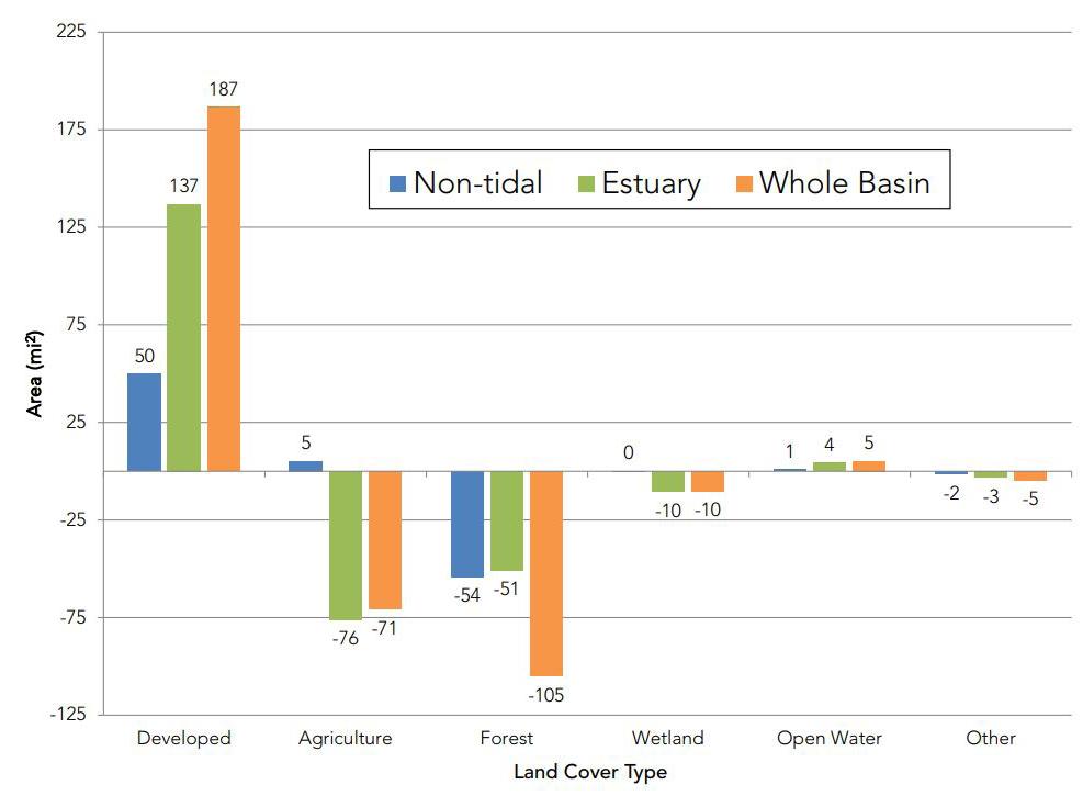
This graph from the 2017 TREB shows the change in land cover type in different parts of the Delaware River Basin between 1996 and 2010, showing that Forest is the land cover type with the greatest acreage lost (See TREB 2017 Chapter 1, Section 1.3 Land Cover Change for more information).
y Promoting increased land acquisition and stewardship. Nearly 15% of the land area of the Basin is protected through conservation easement or ownership, and a variety of organizations and agencies protect and manage forested land for conservation purposes. All three states in the basin (DE, NJ, PA) have active land protection programs that include forest protection among their priorities and resources for conservation easement or fee acquisition. All three states also have agencies that hold and manage forested lands for conservation and recreation purposes. Further, the Basin has a host of very successful private land trusts that protect, own, and manage forested lands. Continuation and expansion of these efforts with a focus on priority forested lands is critical.
y Provide education and outreach on forests. While government entities own most of the forested lands in the Basin, there are still numerous large parcels owned and/or managed privately. These include lands individuals, farmers, companies, and recreational clubs own that potentially are subject to conversion to other non-forested uses. Education and outreach to these landowners to increase awareness of forests’ value and options for permanent protection will help minimize conversion over time. Education and outreach to local municipalities on forests, land use planning, and municipal land protection and stewardship’s value also will help minimize conversion over time.
y Explore and develop economic incentives. Protecting land permanently is expensive. Economic incentives, such as tax incentives for the permanent protection of forestland, can help ease this financial burden and accelerate protection and hence, they should be developed and/or supported. Land protection funding programs often do not cover various miscellaneous costs associated with permanent land protection (e.g., surveys, legal costs), so finding ways to provide even a small amount of support for these costs can create a meaningful
incentive. Partners have efforts underway to explore opportunities to use carbon markets and/or state-wide initiatives for tax benefits as incentives for forest land protection that should be encouraged/ supported.
y Address and protect smaller parcels of forested areas that belong to private landowners. It is necessary to protect private landowners’ forested areas to address fragmentation and aging landowner challenges. Partners have efforts underway to test methods to motivate these landowners to think of conservation routinely before selling their conservation lands that should be encouraged and promoted.
The states (DE, NJ, PA) and conservation program partners implement this strategy primarily, because of their programs, expertise, and funding capacity. Federal programs, such as the Land and Water Conservation Fund, USDA Forest Legacy Program, the Highlands Conservation Act, the North American Wetlands Conservation Act, and work by the Federal Emergency Management Agency (FEMA) and state floodplain management offices on forested floodplain and buffer protection also support and/or supplement state (and private) activities. Further, local municipalities and conservation districts play key roles by providing information and technical assistance to landowners. Actions the PDE and others can take to support this strategy include promoting the importance of these state, federal, and local land protection programs and efforts and their continued/expanded funding; providing opportunities to collaborate and share information and lessons learned, and researching ways to track progress to tell the story of the Estuary’s recovery. The DELEP potentially would collaborate with partners involved in the DRWI.
If development trends in the Delaware River Basin increase to pre-2008 levels, we can expect to see increased conversion of critical forestlands and an increase in the cost of land per acre, which will make protection efforts more challenging and expensive. Further, there is mixed support
for preserving forests in rural areas that can create constraints; perceptions often cited are about lands being removed from tax rolls and losing land use control if lands are preserved permanently. Creating, supporting, and promoting programs that help offset these effects could help address these constraints. Climate change will affect forests in a variety of ways, including potentially changing the mix of forests’ species and their vulnerability to pests and invasive species. Accordingly, protection priorities should be reevaluated periodically to adapt to these changes.
Performance Measures and Key Deliverables
y Place an additional 50,000 acres of forests under permanent protection by 2025 with examples that
preserve or enhance forest connectivity in each state.
y Develop new partnerships to encourage economic incentives and opportunities for forest stewardship for landowners.
y Track number and results of landowner outreach forest protection projects.
Costs and Funding
y Estimated Cost Range: $$$$$$
y Possible Funding Sources: Federal grants (Land and Water Conservation Fund, Forest Legacy), municipal open space funding, private foundations and land trusts
Purpose
To maintain water quality and quantity in the Delaware Estuary through forestlands protection.
Core Partners
Partnership for the Delaware Estuary, States (DE, NJ, PA)
Key Partners
Delaware River Watershed Initiative partners, NonGovernmental Organization land trust community, United States Department of Agriculture - Forest Service and Natural Resource Conservation Service, United States Fish and Wildlife Service
Contributing Partners Forest landowners
Timeframe
10 years
Bombay Hook National Wildlife Refuge, Smyrna | Credit: Norma Worley
GOAL 3: INCREASE AND IMPROVE FISH AND SHELLFISH HABITAT
The Delaware Estuary is home to a host of fish, shellfish, and other wildlife, including some that are important for clean waters and strong communities. Some species, such as oysters and mussels, grow into reef habitats that are vital for other organisms, and also filter vast quantities of water for food, a process that helps clean the water. Key shellfish species include oysters and ribbed mussels in the Bay, and beds of freshwater mussels in rivers, streams, and ponds. The horseshoe Intertidal oyster beds at the
Mispillion Harbor in Milford, DE. | Credit: PDE
Fish and Shellfish Habitat
crab is another ecologically significant species that is an important bottom feeder and helps many bird species by laying its eggs on beaches. Horseshoe crab eggs feed millions of shorebirds that stop in the Delaware Bay in their annual migration. Iconic fish, including sturgeon and shad, once fed the people and economy of the New World, and required healthy estuary waters to live and spawn. Thus, robust populations of these fish and shellfish signify a healthy Delaware Estuary.
Most ecologically significant fish and shellfish species in the Delaware Estuary have a rich and event-filled history. For example, oysters are sensitive to water pollution and salinity, and their populations have declined dramatically since the 1950s because of the introduction of foreign diseases that do not affect humans, but are lethal to oysters. Today, oyster populations have rebounded to some extent thanks to sound management, sustainable fishing practices, development of some disease resistance, and restoration investments such as shell planting. At the same time, current populations of freshwater mussels are depressed significantly. In fact, freshwater mussels are now the most imperiled group of animals locally and nationally because of dams, degraded water quality, and other factors. Many groups are now working together to protect the most endangered species, and restore their range and abundance. Ribbed mussels are another key bivalve that is most abundant in coastal marshes around the Delaware Bay, where they help strengthen the edge of the marsh and filter large amounts of pollutants. However, ribbed mussels face a different challenge—their habitat is washing away because of erosion.
Although Delaware Bay is home to the largest breeding population of horseshoe crabs in the world, they have been over-harvested at times in the past for use as fertilizer, tools, and fish bait, and past
declines in the horseshoe crab population have corresponded with declines in shorebird populations. Today, the Bay’s horseshoe crab population appears to be stable and likely to rebound further thanks to harvest restrictions, but still remains low compared to historic levels.
Similar to oysters and horseshoe crabs, shad and sturgeon supported robust fisheries historically, but populations in the Delaware Estuary plummeted because of pollution and over-harvesting. A 1998 moratorium on Atlantic sturgeon fishing did not increase the population, and thus, they were listed as an endangered species in 2012. In 2016, The National Marine Fisheries Service issued designations of critical habitat protections for the Atlantic sturgeon to help increase population levels.
Despite past declines, water quality has improved dramatically in recent decades, together with dam removals and other habitat investments, which appear to be helping many of these fish and shellfish begin to recover. For example, several fish species are beginning to reproduce again in the urban Delaware Estuary. As a result of dam removal projects, shad now can migrate to many historic streams that were blocked previously. Planting shells in Delaware Bay to provide settlement surfaces for larval oysters has helped stem the loss of historic fishing reefs. Although Hurricane Sandy decimated some of the most important horseshoe crab spawning beaches around Delaware Bay, the restoration community’s rapid restoration effort helped reverse those declines. The periodic presence of juvenile Atlantic sturgeon and reproduction on the part of some native mussel species within the urban corridor of the Delaware River suggest that dwindling populations of even those species have the potential to be restored with continued assistance.
Fish and shellfish provide diverse social, economic, and ecological benefits, and a healthy Delaware Estuary depends on their wellbeing and abundance. The current status of most of these species is considerably depressed compared to historic conditions, but careful management and restoration efforts have helped stem their declines, and in some cases, have begun to rebuild the stocks. This demonstrates that environmental investments are effective and lead to quantifiable improvements. Continued investments will be needed, especially considering the emerging constraints that are discussed for each strategy below.
HOW WE WILL MEASURE SUCCESS:
• Improve shellfish habitat and abundance and oyster productivity
• Improve habitat for fish and crabs
• Increase and improve fish/shellfish restoration projects
Bombay Hook National Wildlife Refuge, Smyrna | Credit: Benjamin Andersen
STRATEGY H3.1: Inventory, map, protect, and enhance habitat critical for fish and crabs
Description
The Delaware Estuary consists of many different types of aquatic habitats that support fish and crabs, ranging from small headwater streams to large rivers, tidal tributaries, and the open Delaware Bay. Bottom conditions vary from rocky riffles to sandy and muddy areas. Diverse fish and crab species often depend on specific bottom features, and are more abundant and healthier in some areas compared to others. For example, blue crabs are abundant in tidal habitats containing submerged grasses, while horseshoe crabs require unimpeded access to sandy beaches to lay their eggs. Atlantic sturgeon need oxygen-rich hard bottoms to lay their eggs. Many other fish depend on tidal marshes or structurally complex reef habitats either to forage or reproduce. In addition, many fish need to move into different habitats at different life stages, and dams and culverts, for example, impair connectivity between habitats frequently.
Understanding and mapping these critical habitats is important so that these benthic (bottom) areas can be protected and restored. Pairing these maps with climate change and watershed development forecasts guides efforts to enhance fish and crab populations’ health in strategic places, thus providing optimal use of precious restoration resources.
Major components of this strategy include:
y Assess benthic habitat throughout the Estuary. Benthic organisms often are surveyed to assess bottom habitats’ ecological health because their abundance and species diversity varies between degraded and undisturbed sites. Benthic surveys also examine physical conditions
and detect the presence of unhealthy chemical compounds. A benthic survey of more than 230 locations was conducted in the Delaware Estuary in 2008, and augmented earlier studies since the 1950s. Acoustic surveys also have helped map benthic habitat types in some regions. However, some gaps in coverage of past benthic and acoustic surveys still need to be addressed. To track changes in conditions, these surveys also should be repeated at 5- to 10-year intervals. Integration and
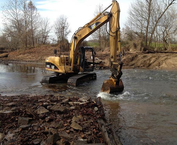
Dam removal on White Clay Creek in Newark, DE. | Credit: White Clay Watershed Association
cross-comparison of historic and recent benthic survey datasets also are needed. New technology should help reduce costs and increase coverage for future benthic habitat assessments. The EPA currently is funding a RARE project that involves benthic submerged aquatic vegetation surveys in the Delaware Estuary.
y Restoring fish passage. Many fish species need to swim up or downriver to reproduce and complete their life cycle, such as American shad, alewife, American eel, and blueback herring. Dams, culverts, and tidal restrictions impede diadromous fish’ passage and resident species’ dispersal. Removing impediments to fish is an effective tactic to increase their habitat and boost their population health. The Delaware Estuary has a very high concentration of fish passage impediments, and strategic coordination among management agencies and fish biologists can help prioritize efforts to improve fish passage. Most blockages are in feeder tributaries to the Estuary. Partners, including American Rivers and NOAA, could help secure funding for these projects.
y Supporting shad propagation. American and hickory shad are anadromous species native to the Basin and are popular sport fish. Historic shad-spawning ground has been lost because tributaries to the Delaware, including the Lehigh and Schuylkill Rivers, have been dammed. Funding is needed to continue monitoring shad populations and enhance them through protection of spawning habitat and fish passage. Support for shad propagation and restocking also would expedite recolonization to historic tributaries once fish passage is restored. The PWD and the Pennsylvania Fish & Boat Commission have efforts underway to develop a shad hatchery, which will improve shad propagation greatly.
y Creating and sustaining reef habitats. Complex bottom habitats, such as reefs of oysters and sabellid worms, are important fish habitat. Therefore, investments in natural and artificial reefs and research on
successful designs can increase and improve many fish and shellfish species’ habitats. These habitats also support a diverse reef community, including reef fish (e.g., sea bass, spadefish). DNREC started an artificial reef building program in 1995 that should be sustained and/or expanded. Recycling oyster and other shells also is needed to restore reefs, as placement of clean shells promotes fastest recruitment of reef organisms, such as oysters, and the lack of availability of clean shells has hampered reef restoration (See Strategy H3.2 for more information on current oyster shell recycling projects).
y Promoting research on spawning and nursery areas for fish, including sturgeon. In 2012, the National Marine Fisheries Service declared Atlantic sturgeon in the New York Bight region (includes the Delaware Estuary) an endangered population. NOAA Fisheries also has designated the Delaware River, including the full bank width of the main stem river within the upriver and downriver boundaries, as critical habitat for the Atlantic sturgeon. Atlantic sturgeon spawning does not occur annually, and there is concern that suboptimal dissolved oxygen levels in the summer could be affecting sturgeon larvae’s survival. More research is needed to identify and improve ecologically significant fish species, such as Atlantic sturgeon’s, habitat and water quality requirements. The timing of disturbance activities (e.g., dredging, shipping) should continue to be adjusted to avoid impacts to spawning and from ship strikes.
Different organizations and agencies play leading roles in each of these efforts. State and federal wildlife agencies and fisheries management agencies are taking the lead to identify and take actions to improve habitat for sturgeon and other fish. State fisheries management agencies in Delaware and New Jersey have taken the lead in acoustic surveys and creating and sustaining reef habitat. Both the Pennsylvania Fish & Boat Commission and PWD have played leading roles in fish passage
and shad propagation, and work with a variety of other partners, including American Rivers and the University of Delaware. PDE played a significant role in benthic habitat assessment working with the University of Delaware, the DRBC, and the EPA. To maximize fish and crab populations’ habitat improvements, these and other partners will continue to coordinate and share information about surveys, monitoring, research, and restoration activities via the biennial Delaware Estuary Science and Environmental Summit, workshops, technical and management workgroups, and online media. Because many fish and shellfish species are vulnerable to rising temperature, storminess, sea level, and salinity, investments in critical fish and crab habitat should be strategic in considering future sustainability.
Climate change and the watershed’s continued development could have large effects on this strategy that could include, but are not limited to, an increase in storminess that could degrade or destroy sensitive fish and crab habitats directly, such as beds of submerged vegetation, tidal marshes, horseshoe crabs’ spawning beaches, or nearshore reefs. Warmer water holds less dissolved oxygen, which could constrain access to key habitats at critical times, such as happened in the urbanized portion of the Delaware Estuary in earlier decades. Fish and crab species that are adapted uniquely to freshwater tidal conditions likely will have less habitat because of
increasing salinity associated with rising sea levels. However, rising sea levels and decreasing winter temperatures could expand certain fish and crab species’ habitat niches and growing seasons. Indirect effects, such as the changing availability of prey organisms or water quality, also could constrain biological fish and crab habitats, such as oyster reefs and submerged grass beds.
Performance Measures and Key Deliverables
y Complete a baseline benthic map of vegetated and hard-bottom reef habitats throughout the tidal Estuary and develop a strategy to update benthic maps periodically.
y Make progress in restoring fish passage by alleviating at least one obstruction per state.
y Develop a sustained propagation and restocking program for shad.
y Track the number and results of restoration, enhancement, and mapping projects for fish/ crab habitat.
Costs and Funding
y Estimated Cost Range: $$$$
y Possible Funding Source: Federal, state, private grants (National Fish and Wildlife Foundation, American Rivers)
Purpose
To increase and improve aquatic habitats so they can support healthier and more abundant fish and crabs.
Core Partners
Delaware River Basin Commission, Partnership for the Delaware Estuary, Philadelphia Water Department, States (DE, NJ, PA)
Key Partners
American Rivers, Fisheries management agencies, National Oceanic and Atmospheric Administration, United States Fish and Wildlife Service, University of Delaware Water Resources Center, other Science and Technical Advisory Committee member organizations
Contributing Partners
Atlantic Coastal Fish Habitat Partnership, National Fish and Wildlife Foundation, United States Department of Agriculture
Timeframe
Mapping of critical bottom habitats and sharing results to use in strategic planning to prioritize projects and management actions can be implemented now or in the short-term. A repeat of the 2008 benthic survey also is needed soon. Investments in vital habitats, such as dam removal, is ongoing and contingent on funding.
STRATEGY H3.2:
Restore oyster beds and productivity in and around the Delaware Bay Description
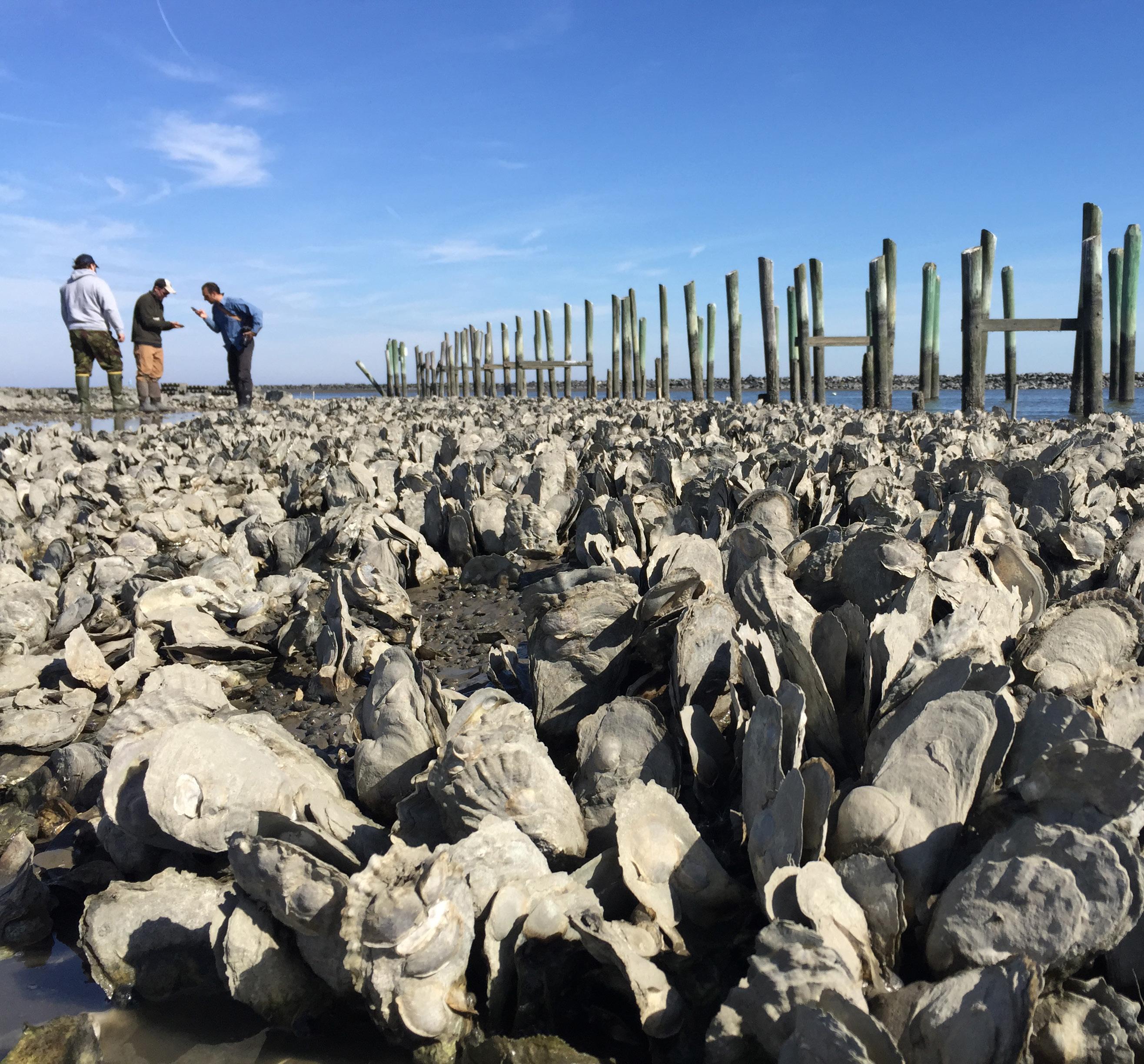
Historically, the eastern oyster’s commercial importance has driven efforts to restore oyster beds and productivity within the Delaware Bay. Although oyster populations are well below their historic numbers, the population has been relatively stable recently and harvesting wild oysters is considered a sustainable fishery thanks to proactive shellfish bed management and investments in shell planting. In addition to their historical and contemporary commercial importance, oysters also are valued highly for their ecological benefits. Oysters are considered “ecological engineers” that increase habitat complexity, stabilize
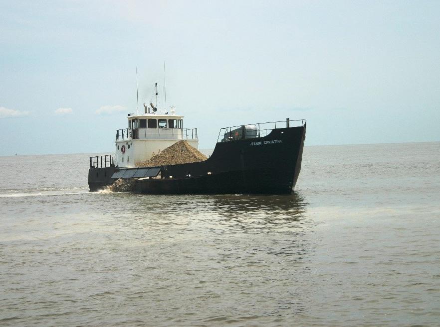
Aggressive shell planting from 2005 to 2009 by the Delaware Bay Oyster Restoration Task Force brought oyster populations in Delaware Bay back from the brink of collapse and demonstrated a $40 to $1 return on investment of federal dollars based on dockside value. | Credit: PDE
sediments, and help sustain water quality, thus providing many benefits to people and fish and wildlife alike.
Recent advances in oyster aquaculture, living shorelines, shell recycling, and public awareness provide additional opportunities and interest that supports oyster restoration in Delaware Bay. Many partners are involved in this strategy to promote and restore Delaware Bay oysters, ranging from state governments (DE, NJ) to non-governmental organizations. Key activities are presented below with descriptions of their current status and future goals:
y Support oyster management. Delaware Bay oysters’ current management is achieved through a collaborative effort involving resource managers, academia, and shellfish harvesters. Harvests and restoration planning are guided by monitoring trends in oyster population abundance and demographics carefully. This approach sets Delaware Bay apart from many oyster fisheries, and is the reason that many consider it sustainable. Continuation of this successful oyster management approach, including monitoring, is important to sustain oyster populations. The Rutgers Haskin Shellfish Research Laboratory plays a leading role in managing and studying Delaware Bay oysters and works with the New Jersey Shellfish Council, NJDEP, and DNREC.
y Promote shell planting. The planting of cured shells at the right time of the year is a method proven to enhance the natural recruitment of oysters on productive beds greatly. Aggressive shell planting from 2005 through 2009 demonstrated its effectiveness and showed that a $1 investment in shell planting could result in up to a $40 return on dockside value. This cost-effective restoration strategy is credited with saving the oyster industry in Delaware Bay, and currently is performed primarily on a volunteer basis by oystermen using “cultch funds”—the voluntary tax put on oyster harvests to support restoration efforts. More aggressive shell planting is needed and has great potential to enhance
both commercial and ecological benefits. Increased shell recycling would help resupply shells on which young oysters grow. The NJDEP and DNREC play leading roles in shell planting, working closely with the industry through the NJ Shellfish Council, and with partners in the Delaware Bay Oyster Restoration Task Force.
y Support oyster aquaculture’s expansion. To complement wild oyster harvests and meet the growing demand for seafood products, interest in oyster aquaculture has been increasing. When oyster aquaculture operations are situated and scaled appropriately, they have the potential to promote diverse economic and ecological benefits. Unlike some forms of fish aquaculture, farms of bivalves such as oysters may enhance water quality because they are filter-feeders. Although more research is needed, nearshore oyster aquaculture also has the potential to buffer waves and potentially help address shoreline protection needs. Mixed-use conflicts can arise with some forms of oyster aquaculture; however, careful and strategic planning has the potential to resolve temporal and spatial resource conflicts. Where appropriate, oyster aquaculture may be expanded to support local economies, enhance ecological goals, and help alleviate fishing pressure on wild oyster stocks. Oyster aquaculture also helps stabilize the supply of oyster seed needed for other restoration projects, depending on state regulations (DE, NJ). Rutgers, NJDEP, and the NJ Shellfish Council play leading roles in oyster aquaculture in NJ, and there is growing interest in aquaculture in Delaware as well, where DNREC has begun a new program for the Inland Bays.
y Incorporate oysters into living shorelines. Living shorelines represent an ecologically beneficial alternative to traditional armoring methods to stabilize shorelines and promote coastal resilience to flooding. Many types of living shorelines, such as new hybrid designs, incorporate oysters and other bivalve shellfish in their designs. Oysters
and
are particularly useful because they cement together to hard surfaces, which promotes structural integrity, while also benefiting water quality and other fish and wildlife. By expanding oyster populations, these reefs created in the bay perpetuate oysters that potentially serve as broodstock directly. With warming temperatures and reduced winter kill, oyster populations also are expanding their colonization of Delaware Bay’s intertidal areas, presenting new opportunities to achieve oyster restoration via living shorelines. PDE plays a leading role in developing living shorelines as a viable restoration option, incorporating and enhancing oysters and working closely with the Rutgers Haskin Shellfish Laboratory, The Nature Conservancy, and state (DE, NJ) and federal agency partners.
y Provide outreach on oysters. Oyster outreach efforts promote awareness of both this vital resource’s commercial and ecological value. Outreach efforts, such as shell recycling initiatives, vary from inschool lessons and curricula to outreach at local restaurants and markets where oysters are sold. This increased awareness of Delaware Bay oysters’ importance helps sustain the interest and support needed for oyster restoration. In particular, shell recycling links oyster restoration with consumers directly, but also acts as a supply of oyster shells for restoration projects and potential shell planting. Current regulations prevent residential oyster growing (e.g., oyster gardening), but future outreach may include
such activities as opportunities arise. PDE led a major marketing and outreach campaign to promote Delaware Bay Oysters as part of 20052009 shell planting efforts, and continues to promote the oysters’ success story and the positive effect they have had because of shell planting as a central theme of its public outreach. In 2015, PDE started the Delaware Estuary Shell Recycling program with the dual goals of returning shells to the Bay and raising awareness about oysters’ benefits. The Rutgers Haskin Shellfish Research Laboratory also has played a leading role in oyster outreach; they established PORTS (Promoting Oyster Restoration Through Schools), a program that engages schools and volunteers in learning about and creating oyster reefs.
The partners identified above are committed to continuing and increasing these efforts to restore oyster habitat and productivity throughout the Delaware Bay.
Oyster reefs consist of living organisms, and therefore, are dynamic systems subject to environmental factors such as temperature, salinity, food conditions, and disease pressure. As climate changes lead to changes in these environmental conditions, oyster restoration efforts will need to be managed adaptively to maximize oyster population health in the Delaware Estuary. Extreme weather events, rising sea levels and salinity, and possibly ocean acidification represent sources of vulnerability for many estuarine resources, including oysters. On the other hand, oysters may benefit from a longer growing season and expansion of their range from subtidal
into intertidal areas along shorelines, as well as potential colonization and population expansion within tributary systems that are widening and deepening. Additional constraints on oyster restoration include management policies and mixed-use constraints. In some areas, oyster restoration is restricted currently to waters that are classified as open to harvest, as a measure to protect human health from oysters potentially poached from impaired waters. In other areas, permits for oyster restoration projects can be acquired only if the sites were populated with oysters historically, which neglects shifting species ranges associated with changing salinity and other factors. Continued sound management of oyster populations, sustained monitoring, and new scientific and outreach tools, will help inform policy decisions and promote adaptive management of the diverse opportunities and constraints associated with oyster restoration and aquaculture. Some major agencies are hesitant to fund restoration in a system that is harvested actively, which poses an additional constraint on shell planting. Educating these agencies about harvests’ sustainability in the Delaware Bay system, finding ways to use temporary sanctuaries or other tools to address harvesting concerns, and seeking creative new funding/ financing options are needed to address this constraint.
Performance Measures and Key Deliverables
y Sustain effective research, monitoring, and management of oyster reefs, including studies of the ecosystem services oysters provide.
y Secure at least $1 million annually by 2022 to support shell planting that boosts oyster recruitment and productivity.
y Produce and distribute materials promoting oyster restoration and shell recycling (restaurants, volunteers).
y Track the number and results of restoration, enhancement, and outreach projects to measure the number of oysters in the Estuary annually.
Costs and Funding
y Estimated Cost Range: $$$$
y Possible Funding Sources: Federal (U.S. Army Corps of Engineers, National Oceanic and Atmospheric Administration), state and private sector grants, industry clutch tax, state budgets (PA, NJ)
Purpose
To restore and expand oyster populations using scientific management and restoration capacity through innovative techniques. Core Partners
Partnership for the Delaware Estuary, States (DE, NJ)
Key Partners
Delaware Bay Oyster Restoration Task Force, New Jersey Shellfish Council, Shell recycling partners, The Nature Conservancy
Contributing Partners
Bayshore Center at Bivalve, local governments, seafood-related organizations Timeframe
Ongoing
STRATEGY H3.3: Inventory, restore, and manage mussel populations
Description
A variety of mussels inhabit the Delaware Estuary. Freshwater mussels are important bivalves that live in the large freshwater portion of the Delaware Estuary, and ribbed mussels occupy intertidal habitats along the estuary’s fringing marshes. These filter-feeding bivalves improve water quality, diversity, and habitat for other fish and animals in each of their niches. Studies of their current distribution, population density, and ways to manage and restore populations are needed to sustain and increase their populations. Specific activities are broken down by mussel group below:
Freshwater Mussels
Key activities to inventory, restore, and manage all native freshwater mussels are diverse and include a myriad of methods related to their life history.
y Conduct freshwater mussel surveys. Surveys are critical to fill data gaps and provide valuable data either on where to conserve or restore mussels best. As very little is known about different mussel species’ unique habitat needs and water quality requirements, research can fill information gaps that would facilitate understanding why they no longer exist in many areas, and perhaps guide mussel restoration. The PDE has completed surveys on approximately 10% of freshwater streams in the watershed, working with the Academy of Natural Sciences at Drexel University and other partners. Completing surveys on the remaining streams is a priority.
y Promote freshwater mussels’ habitat restoration. Habitat restoration can enhance conditions so that mussels can recolonize or be reintroduced to thrive in areas degraded previously. Dams and other blockages impede fish hosts from traveling upstream, thus blocking
Survey for tidewater mucket (leptodea ochracea, a freshwater mussel) on the Delaware River, in collaboration with the Academy of Natural Science at Drexel University and the Western Pennsylvania Conservancy. | Credit: PDE
mussels from dispersing properly to upstream habitats. These structures’ removal can increase larvae’s transport to these underused stream reaches. However, even in areas where fish blockages are removed, mussels might be slow to, or never return to, the historic waterway. To restore populations to these areas, PDE has been working with the Academy of Natural Sciences at Drexel University and a variety of local partners to transplant mussels in streams and ponds successfully. Efforts are underway currently to create a regional hatchery network to produce juvenile mussels for stocking, and explore the possibility of creating mussel “farms” for nutrient removal.
y Conduct scientific studies on freshwater mussels. Additional scientific studies are needed to assess the ecosystem services natural and restored mussel beds furnish, and understand the threats to them better (e.g., shell erosion). These studies, in combination with freshwater mussel surveys, can help quantify ecosystem services the existing populations of freshwater mussels provide, as well as the potential services that a more robust population would provide.
PDE will play a leading role in implementing these actions for freshwater mussels, all of which are elements of its Freshwater Mussel Restoration Program and the new Mussels for Clean Water Initiative. However, these efforts’ success will rely heavily on partners’ contributions, including those of the Academy of Natural Sciences of Drexel University and the PWD.
Ribbed Mussels
Ribbed mussels thrive along fringing marsh shorelines in brackish waters, and salt marshes are more resilient to erosion in areas where ribbed mussels thrive. Key activities include:
y Conduct ribbed mussel surveys. Large-scale surveys of ribbed mussels are needed to provide data on where they occur and their status in different parts of the estuary (particularly within tidal creeks).
These could be paired with monitoring their preferred salt marsh habitat to assess erosion, the primary threat to their habitat.
y Conduct marsh restoration projects. Restoration projects, including living shorelines, are needed to sustain areas where mussels can continue to flourish. Hatchery propagation of ribbed mussels is still a new technology that has yet to be standardized, but should be considered to supply seed needed for restoration purposes, such as in living shoreline projects. PDE has worked with Rutgers Haskin Shellfish Research Laboratory to develop tactics to restore ribbed mussels.
y Support research and outreach on ribbed mussels. Ribbed mussels have not been studied well because they are not used commercially, but emerging research suggests that they provide valuable ecosystem services such as shoreline protection and water filtration, and therefore, warrant a management plan. Building support for the inclusion of ribbed mussels in future management decisions may require new outreach efforts.
PDE also will play a lead role in implementing these actions on ribbed mussels, with opportunities through the DELSI, Mid-Atlantic Wetland Assessment and Monitoring Program, and by working closely with Rutgers Haskin Shellfish Research Laboratory and others.
Because mussels are sessile, or immobile organisms, generally, they are subject to environmental effects and shifts that may arise. These include environmental changes in precipitation, temperature, salinity regimes, flood zones, and stormwater inputs, as well as large-scale changes, including rising sea levels and ocean acidification. It is unclear currently in what ways mollusks will respond to ocean acidification. Rising sea levels may adjust the habitat available for mussels by shifting shorelines and associated subtidal and intertidal zones. Anthropogenic factors, such as development and their associated effects (e.g., increased
runoff, forest buffer loss) can affect mussel populations adversely throughout the Estuary. Accidental damage to mussel populations also may occur (e.g., oil spill, bridge constructions). Currently, freshwater mussel populations are managed predominantly via conservation-minded heritage programs with state and federal government programs. The focus of state and federal attention on freshwater mussels is imperiled species protection; whereas, the main goal of shellfish conservation and restoration through this strategy is preserving and enhancing ecosystem services that support cleaner water and more resilient coastlines, which are furnished by both common and rare species. This different focus can impose a constraint on awareness and funding support. In contrast to freshwater mussels and oysters, ribbed mussels are not managed because they are not imperiled and are not used commercially. Despite their sizeable ecosystem services and their loss because of habitat erosion, this strategy could be constrained by limited support and lack of awareness about why investments in ribbed mussel populations are worthwhile.
Performance Measures & Key Deliverables
y Increase survey coverage, both scientific and volunteer, annually to assess native freshwater mussels’ status.
y Conduct research and produce one report annually to demonstrate tactics to enhance freshwater and ribbed mussel populations and associated ecosystem services.
y Increase populations of native freshwater mussels annually by enhancing their habitat and expanding propagation and reseeding programs.
y Perform at least one project annually to sustain or enhance ribbed mussel populations, such as via hatchery propagation or use in living shorelines.
y Track the number and results of surveys, research, and restoration projects related to both freshwater and saltwater mussels.
Costs and Funding
y Estimated Cost Range: $$$$ - $$$$$
y Possible Sources: State revolving fund programs (PennVest), state, federal, local grants, mitigation funds, private businesses, water utilities, philanthropic sources
Purpose
Conserve and restore mussel populations to improve water quality, diversity, and resilience in marshes and waterways.
Core Partners
Partnership for the Delaware Estuary, Philadelphia Water Department, States (DE, NJ, PA)
Key Partners
Aquatic Research and Restoration Center partners, National Fish and Wildlife Foundation, United States Fish and Wildlife Service, William Penn Foundation, local partners
Contributing Partners
Delaware Center for the Inland Bays, Delaware State University, The Nature Conservancy, Rutgers University
Timeframe
Activities are ongoing
Longwood Gardens. | Credit: PDE
STRATEGY H3.4: Protect and restore horseshoe crabs and their habitat
Description
Horseshoe crabs can be found all along the eastern coast of southern North America, from the Yucatan Peninsula in Mexico to northern Maine. The Delaware Estuary is unique even among these groups, in that it is regarded widely to have one of the world’s largest populations of spawning horseshoe crabs. Horseshoe crabs are an important part of the marine ecosystem. Their eggs are considered essential food for several shorebird species in the Delaware Bay, which is the second largest migratory staging area for shorebirds in North America. A blood cell extract from the Atlantic horseshoe crab, Limulus amebocyte lysate (LAL) is used to create a test to ensure that medical supplies, such as flu shots and pacemakers, are safe to use. In addition, research on horseshoe crabs has provided valuable insights into the optic nerve, and may help identify cancer treatments. LAL also can detect traces of bacterial presence in medicines and is tested by pharmaceutical companies. Clearly, protecting and restoring horseshoe crabs benefit humans, shorebirds, and the Delaware Bay.
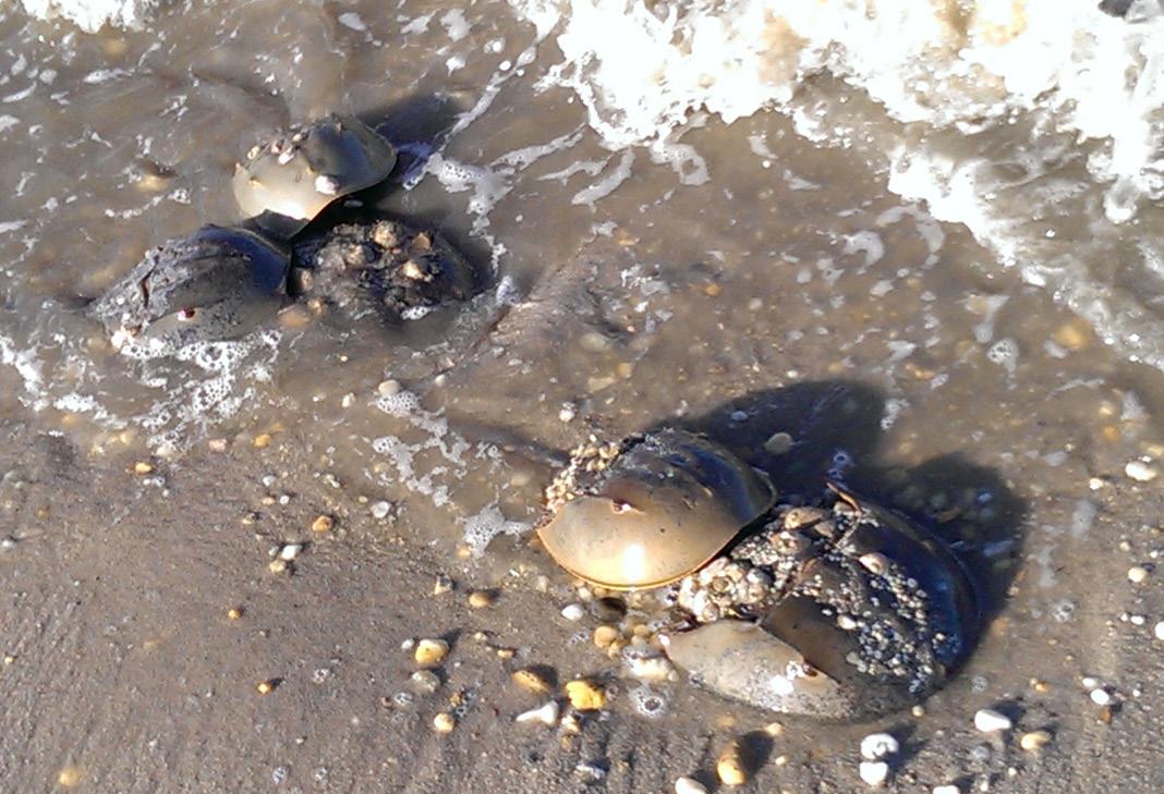
Horseshoe crabs also are useful as an environmental indicator of estuary conditions. Therefore, protecting and restoring horseshoe crabs and their spawning habitat is among DELEP’s important priorities. Many other species of fish and wildlife need these same habitats, and efforts to protect and restore horseshoe crab habitats benefit the overall goal of
Horseshoe crabs during summer spawning season at Slaughter Beach, DE. | Credit: Stacy Small-Lorenz
increasing and improving fish and shellfish habitat. Key activities include:
y Restoring critical habitats, including sandy beaches and intertidal flats. Generally, juvenile horseshoe crabs spend their first and second summers on the intertidal flats, usually near breeding beaches. As they mature, they move into deeper water, eventually into areas up to several miles offshore. Each spring, adult horseshoe crabs migrate from deep bay waters and the Atlantic continental shelf to spawn on intertidal sandy beaches. They are believed to prefer beaches within estuaries, such as the Delaware Bay, because they are low-energy environments protected from wind and waves, and thus reduce the risks of stranding during spawning events. Spawning occurs from April through July generally, with the peak spawning activity on the evenings of new- and full-moon high tides in May and June.
y Conduct research on horseshoe crabs. Horseshoe crab larvae feed on a variety of small polychaetas and nematodes, while juveniles and adults feed largely on a variety of mollusks. Accordingly, research on these food sources and their habitats should be explored. Management of horseshoe crab harvesting coupled with voluntary measures on the part of the bait and biomedical industries can be expected to allow spawning populations of horseshoe crabs in Delaware Bay to increase over time. However, because of past over-harvests, and the length of time needed for horseshoe crabs to reach maturity (8-12 years), populations have not yet shown significant increases in spawning densities relative to what
were believed to be historical levels. Shorebirds depend on eggs that wave action exhumes and high densities of spawning horseshoe crabs are still at low levels. Thus, it is unclear whether current levels of surface eggs are sufficiently high to support shorebirds during typical weather conditions. Horseshoe crab eggs also are an essential food source for shorebirds, including the red knot, during their migration, when they use the Delaware Bay as a stopping ground during their migration. Continuing to study horseshoe crab populations will provide a better
H orseshoe crab sanctuary signs for Money Island and Gandy’s Beach in NJ, created and installed by PDE, ERDG, and 302 Stories | Credit: Ariane Muller
understanding of their behavior and life histories, which in turn, provides a better understanding of which habitats to restore and protect.
y Conduct surveys and monitor horseshoe crabs. Surveys are conducted to help understand populations and set regulations. The Spawning Survey redesigned in 1999 is an important survey conducted under the direction of the Atlantic States Marine Fisheries Commission’s (ASMFC) Interstate Fishery Management Plan for Horseshoe Crab, together with state agencies. The survey provides an index of spawning activity at the Bay-wide scale. It is important to recognize that this survey gives an estimate of density and should not be used to estimate population size. Instead, it provides a useful measure of spawning crabs’ relative abundance or density and trends in spawning density.
y Provide adaptive management for horseshoe crabs. The ASMFC has implemented an adaptive management framework to help set harvest regulations that uses the best information available to link shorebird and horseshoe crab models in a way that predicts harvests’ effects on both horseshoe crab and red knot populations. By projecting these effects into the future and optimizing the results, the framework recommends harvest levels that will allow both species to recover. Two monitoring programs are key elements of this, and the ASMFC has facilitated their establishment. One is the horseshoe crab trawl survey, and the other is the Delaware Bay Shorebird Monitoring Program. These estimate the size of the horseshoe crab and red knot populations, respectively, which is used to determine the appropriate annual harvest recommendations. Continuing these annual surveys will increase knowledge about horseshoe crab spawning behavior, and allow prioritization of horseshoe crab habitats that may require protection.
y Support funding for horseshoe crab monitoring. The Horseshoe Crab Trawl Survey and the Shorebird Monitoring Program at Delaware Bay are critical to the Adaptive Resource Management Framework, which incorporates both shorebird and horseshoe crab abundance levels to set horseshoe crab harvest levels for the Delaware Bay. It is a high priority to ensure funding for these two monitoring programs to increase understanding and reduce uncertainty about the way these two populations interact. The results will help make more informed recommendations for horseshoe crab harvesting, which will affect their populations directly.
y Provide education, outreach, and volunteer stewardship on horseshoe crabs. Horseshoe crabs provide a compelling story and a variety of opportunities to involve the public in the Delaware Estuary, especially in the role of citizen scientists. Hundreds of volunteers are recruited annually in spawning surveys the USFWS, NJDEP, DNREC, and a variety of conservation organizations, coordinate. Volunteers also are critical to the Shorebird Monitoring Program on both sides of the bay. The “Just Flip ‘Em” and “ReTURN the Favor” programs ERDG and Manomet lead, respectively, encourage local residents to rescue crabs that have become stranded properly. ERDG’s Horseshoe Crab Beach Sanctuary program allows these communities to be horseshoe crabs’ designated stewards, and provides signage and recognition. PDE developed a horseshoe crab plush toy with an educational tag that offers information about them and the Delaware Estuary. These opportunities, together with dozens of educational programs DNREC and other partners run annually, tell the story of horseshoe crabs and shorebirds and build public stewardship—not just for these amazing creatures, but for the Delaware Estuary as well.
A wide variety of organizations and agencies is active in horseshoe crab protection and management in the Delaware Estuary. The USFWS, NJDEP, and DNREC, as well as a variety of conservation organization partners, including ERDG, Manomet, and the American Littoral Society, will continue to take the lead to implement elements of this strategy as described
above. Telling the story of horseshoe crabs with the plush toy, through educational programs and materials, with supporting signage for sanctuary communities, and by promoting volunteer opportunities, will remain priorities for PDE and a variety of partners for the foreseeable future.
In 2012, Hurricane Sandy affected horseshoe crab spawning beaches’ abundance and condition significantly. Thanks to significant post-Sandy funding and the conservation community’s rapid mobilization, many of these sandy beaches were restored promptly in time for the subsequent spawning event. This demonstrates that one constraint on the management of horseshoe crab habitat will be the frequency and intensity of severe storms, which can counteract efforts to improve and sustain spawning beaches. Other potential constraints that could materialize include rising temperatures, acidic conditions, and changes in subtidal benthic habitats. Although horseshoe crabs live in a complex environment, they have survived for millions of years, which could make them rather resilient to external influences. It is impossible to predict fully the way horseshoe crabs and their associated ecological linkages will respond to a changing environment. To assess these changes best, it is crucial to continue tracking changes and manage investments in horseshoe crab habitat and associated research adaptively.
Performance Measures & Key Deliverables
y Sustain annual spawning and trawl surveys of horseshoe crabs and annual shorebird surveys with volunteers.
y Sustain or increase participation in sanctuaries, volunteer flipping activities, and distribution of educational materials (including plush horseshoe crab).
y Increase the number of beach restoration projects to provide high-quality horseshoe crab spawning and shorebird foraging and nesting habitat.
y Conduct research and expand monitoring to understand the habitat needs of juvenile horseshoe crabs.
y Track the number and results of surveys, research, and restoration projects related to horseshoe crabs to increase protection and monitoring/research.
Costs and Funding
Estimated Cost Range: $$$$
Possible Funding Sources: State, municipal, nonprofit partners for monitoring, state and federal grants for restoration (National Fish and Wildlife Foundation, U.S. Fish and Wildlife Service)
Purpose
To protect and restore horseshoe crabs because of the unique role they play and story they tell about the Delaware Estuary.
Core Partners States (NJ, DE)
Key Partners
Atlantic States Marine Fisheries Commission, American Littoral Society, Ecological Research & Development Group, National Fish and Wildlife Foundation, United States Fish and Wildlife Service, Western Hemisphere Shorebird Reserve Network, The Wetlands Institute
Contributing Partners
Academia, Non-Governmental Organizations, bay beach communities Timeframe
Ongoing through annual horseshoe crab spawning, trawl, and shorebird surveys
STRATEGY H3.5: Manage and
improve populations
of rare,
endangered, or otherwise important
native species in the Delaware Estuary Description
In a region the size of the Delaware Estuary, there are millions of species of plants and animals listed as those of conservation concern, and numerous agencies and organizations are devoted to their management. Species management plans (SMP) are integral to the success of improving the Delaware Estuary’s ecological integrity. Designed to enhance survivorship of imperiled (rare or endangered) species or limit invasive species’ adverse effects, SMPs outline specific practices that cater best to species-specific management goals. This also allows agencies or states (DE, NJ, PA) to coordinate efforts efficiently. Although state agencies create their own SMPs generally, for species within the Delaware Estuary, agencies often collaborate to ensure continuity of longterm goals. By engaging a variety of partners, this strategy seeks to conserve species by refining and supporting existing SMPs, helping create new plans for new species management issues as they arise, and implementing the conservation actions these plans recommend.
In particular, SMPs will be used to:
y Assess and manage cumulative effects. Where there are cumulative effects of concern to the Delaware Estuary’s health (those the combined results of past, current, and future activities cause), SMPs for imperiled or otherwise important species (such as those of economic or ecological importance) may be refined or redeveloped by focusing on those species or a suite of species (e.g., fishes, nektonic animals, bivalves, wading birds, crustaceans) to ensure improvements Estuary-wide. Cumulative effect inventories also may include multiagency strategies to eliminate key threats to imperiled species’ recovery, such as advocating dam removal for anadromous fish or supporting pesticide BMPs to limit chemical exposure.
y Manage invasive species. Invasive species that threaten the Delaware Estuary’s ecological integrity affect many species. By reviewing SMPs, partners in the DELEP can identify those invasive species that present the greatest risks and work with partners to control, as well as prevent, their effects. Consistent and collaborative efforts to manage invasive species is important to ensure efforts’ long-term success. Furthermore, multiagency contingency plans for invasive species are important to respond swiftly
A Guide to the Natural Communities of the Delaware Estuary, which describes 35 ecological systems and 185 natural communities known to occur in the region.
when problematic species known already, but not yet naturalized across the Delaware Estuary, are detected, including the zebra mussel (Dreissena polymorpha).
y Promote native species and communities. SMPs also help identify the habitats multiple species use and suggest the most strategically important habitat to protect and restore to preserve native plants and animals’ diversity in the Delaware Estuary. Information from SMPs, as well as resources such as the Natural Vegetation Communities System PDE developed in 2007, can and should be used not only by managers to shape priorities, but by interested members of the public (gardeners, naturalists) to raise awareness and build stewardship for native species. SMPs also can be translated for those with limited English proficiency.
State and federal agencies, including the NJDEP, PADEP/ Pennsylvania Department of Conservation and Natural Resources, DNREC, and the USFWS, are this strategy’s lead implementers. PDE and others can play a supportive role by helping identify SMPs’ needs, and advocating for their continued use.
Such external constraints as climatic variability, environmental accidents (e.g., oil spills), disease, funding, and political attitudes affect SMPs’ success and the collaboration among agencies on which this strategy focuses significantly. To mitigate certain constraints, when updating existing, or creating new SMPs, management plans should acknowledge and prepare for certain
changes, such as rising sea levels, ocean acidification, climate change, or increased developmental or economic pressures. Contingency plans might be outlined for each SMP with respect to environmental accidents and disease, should the need for action arise. Most likely, the best way to deal with funding availability and political attitudes is to make SMPs and outreach materials consistent to inform various audiences better about key species’ importance and the detriments of certain conditions (e.g., dams, pollution) to the Delaware Estuary’s health overall.
Performance Measures and Key Deliverables
y Use SMPs to assess the cumulative effects of impingement/entrainment on ecologically important native species.
y Develop contingency plan for zebra mussels.
y Work with partners to identify and reduce habitat acres affected by invasive species annually in each state.
y Perform annual outreach to increase stewardship and landowners’ use of native species.
y Track the number and results of species-related projects.
Costs and Funding
Estimated Cost Range: $$$
Possible Funding Sources: Agency operating funds, state, federal, and private grants (e.g., iMapInvasives)
Purpose
To work collaboratively to improve the management of key species in the Estuary.
Core Partners Partnership for the Delaware Estuary, Philadelphia Water Department, States (DE, NJ, PA)
Key Partners
National Fish and Wildlife Foundation, United States Fish and Wildlife Service
Contributing Partners
Delaware Invasive Species Council, United States Coast Guard Ballast Water Management System, fisheries management organizations, private sector Timeframe
Ongoing