7 minute read
AN IMPERIAL ROMAN WORLD VIEW

ORTELIUS, Abraham; Johannes JANSSONIUS; and Georgius HORNIUS
Tabula Itineraria ex illustri Peutingerorum Bibliotheca Que
Augustae Vindelicorum Beneficio
Marci Velseri Septem-viri
Augustani in Lucem edita.
Publication
Amsterdam, Prostant apud Joannem Janssonium, 1652.
Description
Eight engraved road maps on four mapsheets, with fine hand-colour in full
Dimensions each sheet: 470 by 585mm (18.5 by 23 inches).
References
Koeman, ‘Atlantes Neerlandici’, 5 volumes, 1967-1971’, Ort 46; Shirley, ‘The mapping of the world: early printed world maps, 1472-1700’, 2001, 212 and 393; Suarez, for the Map & Atlas Museum of La Jolla.
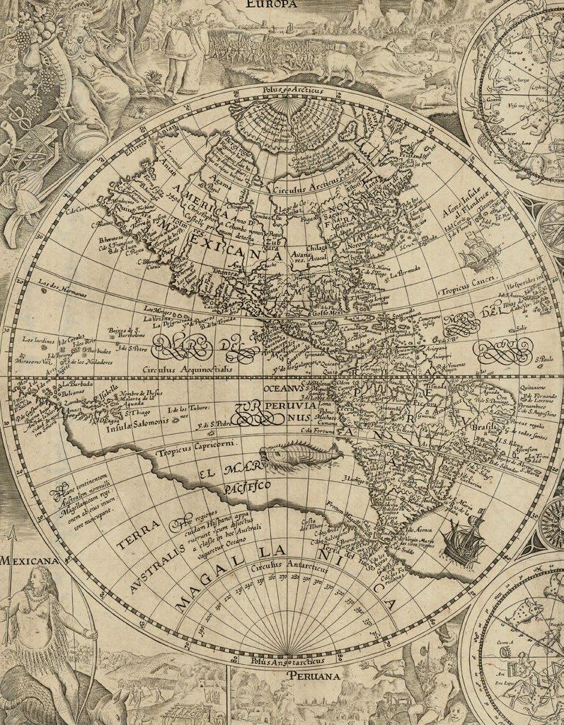
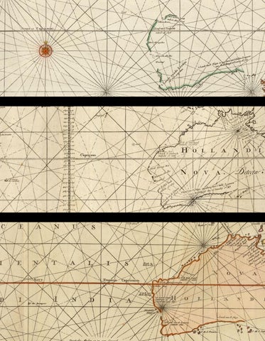
The “’Terra Australis’ narrative of discovery begins with… the ‘Tabula Peutingeriana’, the earliest manuscript road map covering the extensive network of the Roman Empire” (Clancy), and extends from the British Isles to India and Sri Lanka.
The so-called “Peutinger Table”, is named for Konrad Peutinger (1465-1547) a German lawyer and antiquarian scholar, who owned the only surviving manuscript, now in the Osterreichische Nationalbibliotek, Vienna, believed to have been made at Colmar in 1265. The map, measuring more than twenty-two feet in length, came into Peutinger’s possession after the death of his friend Konrad Bickel, who was librarian to Maximilian of Austria. It was a medieval copy of a much older, and more extensive map, probably drawn in the fourth century, as it incorporates information regarding “the imperial roads and posts throughout the Roman Empire at about 250AD, with some later additions up to c500AD” (Shirley). That original, in turn, was probably an updated copy of one made in the first century AD, since it contains a few anachronisms, such as the inclusion of Pompeii, which was destroyed in 79 AD.
Roman settlements and their connecting roads are shown, with distances between them marked. “Most important of the cities are Rome, Constantinople (Istanbul), and Antioch (southern Turkey). A total of 70,000 miles of roads are recorded, with various features useful to the traveller marked. These include staging posts and the distances between them, forests, rivers, and spas. The long-distance traveller had to adjust to local units of measure. On most of the map, distances are recorded in Roman miles; but in Gaul they are in leagues, in Persia they are in parasangs, and in India they are in an Indian unit” (Suarez).
The map was first printed in 1591 by Johannes Moretus in Antwerp. It was then reduced and printed with two sections to a sheet in Balthasar Moretus’s 1624 edition of Abraham Ortelius’ ‘Parergon’; then again, as here, from 1652-1657, in Johannes Janssonius’ editions of Georgius Hornius’s ‘Accuratissima Orbis Antiqui Delineatio’, and again in 1677 and 1684 by Johannes Janssonius van Waesbergen. An edition was also published in England in 1641.
PTOLEMAEUS, Claudius; Johannes SCHNITZER OF ARMSZHEIM; and Nicolaus GERMANUS
[Untitled Map of the World].
Publication
Ulm, Lienhart Holl, 1482.
Description
Double-page woodcut map, with fine hand-colour wash in full, small loss to lower margin renewed with manuscript facsimile to neatline and wind name, old central fold strengthened on verso.
Dimensions
415 by 575mm (16.25 by 22.75 inches).
References
Campbell, ‘The earliest printed maps, 179; Shirley, ‘Maps in the atlases of The British Library.
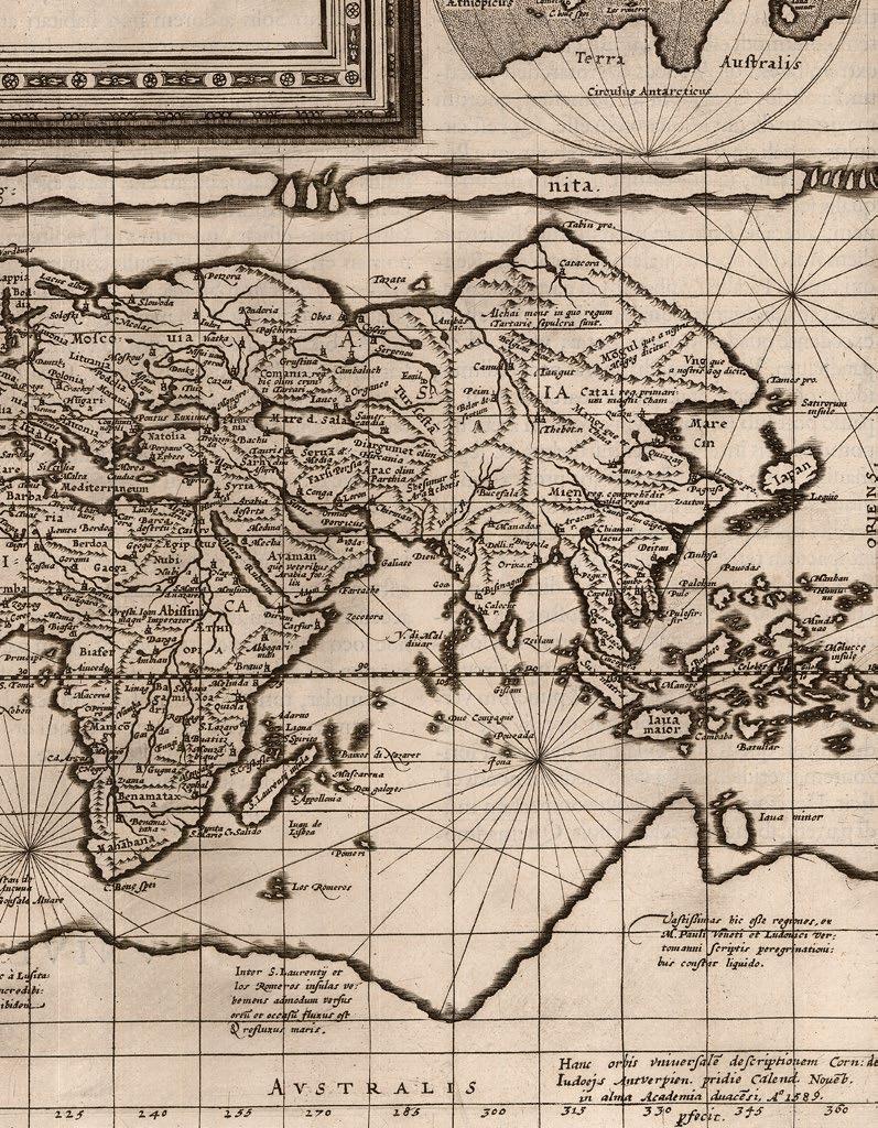
The first woodcut map of the world on a Ptolemaic projection, as it was understood by the Alexandrine ancients, showing what is in essence, the Roman Empire, but with a few “modern” departures. The mapmaker, Johannes Schnitzer (literally John the Woodcutter) of Armszheim, signed in the block by him along the top edge “Insculptum est per Johane Schnitzer de Armszheim”, has updated the Ptolemaic world picture by incorporating improvements that were probably based on a manuscript of the 1470s by Nicolaus Germanus (c1420-1490), a Benedictine monk of Reichenbach Abbey in Bavaria, who is depicted in the first illuminated letter of the complete atlas presenting his book to the dedicatee Pope Paul II.
While the map follows classical lines, this is the first printed world map to show land extending below the Tropic of Capricorn, and is also the earliest printed map to show the northernmost reaches of the Atlantic Ocean, inflaming the imaginations of travellers, and presaging the age of the grand voyages of discovery.
The map extends from Great Britain in the northwest, the Canary islands in the west, mid-China in the east, and northern Africa in the south; the Indian Ocean features a large island, Taprobana, now Sri Lanka; and a rudimentary Scandinavia within an extension of the map above the neatline. Although Africa is connected to Asia by a southern land-bridge, turning the Indian Ocean into a land-locked sea, there is a tantalising note, repeated on Africa, that these southern “Lands were unknown to Ptolemy”,… The whole surrounded by a broad decorative border including 12 windheads.
The text of Claudius Ptolemy’s ‘Cosmographia’ was translated into Latin from the original Greek by Jacobus Angelus and was first published, in Renaissance times, at Vicenza (1475, unillustrated), Bologna (1477) and Rome (1478). The sumptuous edition published at Ulm in 1482, however, far surpassed all earlier efforts and remains one of the most important publications in the history of cartography. This is the first redaction of the ‘Geography’ to be printed outside of Italy, the earliest atlas printed in Germany, the first to depart from the classical prototype to reflect post-antique discoveries, the first to be illustrated with woodcuts rather than engravings, and the first to contain hand-colored maps, the design and execution of which were ascribed to a named cartographer, Johannes Schnitzer of Armszheim, who, in trade-mark fashion has reversed every capital “N”, and inadvertently provided two Tropics of Cancer.
Though printed outside Italy, the paper this magnificent atlas was printed on was imported from Italy, and payment made in part by complete copies of the finished atlas.
Provenance
With the ink stamp on verso, of print dealer Leopold Langer of Kupferstich und Holzschnitt Sammlung.


MÜNSTER, Sebastian
Ptolemaisch General Tafel begreifend die halbe Kugel der Welt.
Publication
Basel, Heinrich Petri, from 1588.
Description
Double-page woodcut map, diagram of winds and climate zones, and German text, on verso.
Dimensions 335 by 400mm (13.25 by 15.75 inches).
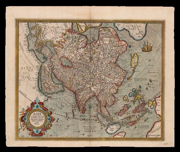
Like other world maps, based on a strictly classical Ptolemaic projection, Munster shows the world of the Roman Empire, and a belief that the Indian Ocean was landlocked, and could not, therefore, traversed by sea from Europe. Asia, is divided, roughly along Ptolemaic principles, in which Southeast Asia appears as a peninsula, which could be construed to equate to Malaya and Indochina; and Sri Lanka appears as “Taprobana”. Also, following classical renderings, the cloak (or chlamys) shaped projection of the map, is surrounded by twelve classical windheads.
When Munster included this classical Ptolemaic map in his ‘Geographia’, as was traditional, it must have also been, at least in part, to make a point: illuminating the striking contrast of it to his maps of the “modern” world published as ‘Typus Cosmographicus Universalis’ (1532), and ‘Typus Orbis Universalis’ (1540). However, Munster could not help himself entirely, in the case of this ‘Ptolemaisch General…’ map of the world, and has adopted the “modern” view that the “Septentrional’ regions” of Scandinavia extend north of the Ptolemaic neatline.
Sebastian Munster issued his first world map on a classical Ptolemaic projection in his ‘Geographia’ (1540). Reprinted, from the same woodblock, for editions published in 1541, 1542, 1545, and 1552, a new one was cut, as here in 1588 for inclusion in Munster’s ‘Cosmographia’, appearing in subsequent editions to 1628.

SCHEDEL, D. Hartman; and Hiernonymous MUNZER
Secunda Etas Mundi.
Publication Nuremberg, Anton Koberger, June, 1493.
Description
Double-page woodcut map, Latin text on verso, pale waterstain along the top edge.
Dimensions 445 by 585mm (17.5 by 23 inches).
References
Shirley World 19; Wilson, ‘The making of the Nuremberg Chronicle’ 1976, pages 98-122.
The world map from the ‘Liber Chronicarum’, or the “Nuremberg Chronicle”, is a history of the world, published the year that Columbus returned to Europe after discovering America, while in search of Paradise, predicted by most medieval commentators to be in the farthest reaches of the earth, i.e. eastern Asia.
Geographically, the map is very similar to the small map added to a new edition of Pomponius Mela’s ‘Cosmographia’ (1482), published by Erhard Ratdolt. It “is a robust woodcut taken from Ptolemy… What gives the map its present-day interest and attraction are the panels representing the outlandish creatures and beings that were thought to inhabit the furthermost parts of the earth. There are seven such scenes to the left of the map and a further fourteen on its reverse… among the scenes are a six-armed man, possibly based on glimpses of a file of Hindu dancers so aligned that the front figure appears to have multiple arms” (Shirley). However, these images are balanced by more familiar and reassuring ones, as the map itself is dominated by the figures of Shem, Japhet and Ham, the sons of Noah whose descendants were believed to have re-populated the earth after the biblical Flood.
Generally, the map follows the classical belief of a landlocked Indian Ocean, with a distorted but clear depiction of the lands of the Far East, and the major innovation of the map is the inclusion of Portuguese discoveries on the west coast of Africa, accounting for the much longer coastline of the continent in comparison to previous Ptolemaic maps. In addition, this map also has a large unidentified island off the west of the continent, perhaps referencing Alvise Cadamosto’s discovery of the Cape Verde Islands in 1456.

PTOLEMAEUS, Claudius; Laurent FRIES; and Johann GRÜNINGER
Tabula Moderna India Orientalis. De Indorvm Moribvs & ritu in tabula decima & vndecima Asiae
Ptholemaei abunde dictum est. tu igitur si placet vide.
Publication
Strassburg, Johannes Gruninger, 1552.
Description
Double-page woodcut map.
Dimensions
370 by 530mm (14.5 by 20.75 inches).
References Suarez, ‘Early Mapping of Southeast Asia’, 1999, pages 114-118.
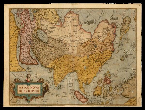
First state of the map of Southeast Asia from Laurent Fries’s edition of Ptolemy’s ‘Geographia’. The woodblock was subsequently re-carved, removing the title and ribbon banner that appears along the upper edge. The map, which shows the Malay Peninsula, Indochina, and some of the islands of Indonesia, “is the first printed map of European origin devoted to Southeast Asia and its islands, and as such is a cartographical landmark, codifying the recognition of Southeast Asia as a distinct entity” (Suarez).
The map’s ancestor is Waldseemuller’s 1507 wall map of the world, in turn “descended from a common ancestor of the old Martellus model – the Southeast Asian subcontinent upon which Fries has mapped the various regions of Southeast Asia, and around which its various islands have been fitted, is simply the phantom vestige of the old Ptolemaic land bridge, the now-abandoned shores of Ptolemaic Malaya and Indochina are seen in the upper left corner” (Suarez).
However, the larger scale of Fries’s map, and his close reading of the accounts of the voyages of Marco Polo at the end of the thirteenth century, are not only reflected in the many placenames on the map, but also in the geography of several of the islands too: “Iava Maior” (i.e. Java), “Peutam” (i.e. Bantam), “Iava Minor” (i.e. Sumatra), are based on textual references rather than earlier maps. Unfortunately, Polo’s compass readings were occasionally lost in translation, so the location of Nicobar and the Andaman Islands, for example, is a bit off course.