9 minute read
THE FLIGHT OF THE LITTLE DOVE

ECKEBRECHT, Philipp
Nova Orbis Terrarum Delineatio singulari ratione accommodate meridian Tabb, Rudolphi Astronomicarum.
Publication
Nuremberg, J.P. Walch, 1630, but after 1658.
Description
Double-page and folding copperplate engraved map, with fine hand-colour in part and in outline, margins extended, upper righthand corner renewed with some manuscript facsimile.
Dimensions 410 by 700mm (16.25 by 27.5 inches).
References
Clancy, ‘The Mapping of Terra Australis’, 1995, 6.4; Dictionary of Scientific Biography, vol. 8, p. 305; Nordenskiöld, ‘Periplus: the early history of charts and sailing directions’, 1897, page 158; Shirley, ‘Maps in the atlases of The British Library: a descriptive catalogue c.AD 8501800’, 2004, 335; Tooley, ‘Landmarks of Mapmaking’, 1976, pages 252-53; ‘Printing and the Mind of Man’, 112; Tooley, ‘Mapping of Australia’, 1979, 541.
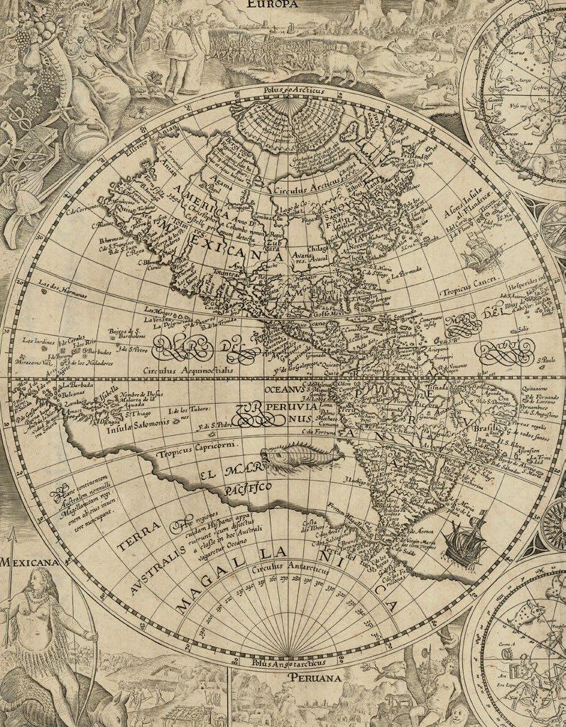
For a long time Philipp Eckebrecht’s map was believed to be the first to show the Dutch discoveries in Australia, but this claim is now superseded by the Cornelis Danckerts, Melchior Tavernier double-hemisphere map of the world, ‘Charte Universelle De Tout Le Monde’ (1628). Nevertheless, this map published by Walch, combines the discoveries on the west coast of Australia, by Dirk Hartog (1616), Frederick de Houtman (1619), and those of Jan Cartensz., further north, in 1623. “New Guinea is erroneously linked to Australia. On the North American continent, Eckebrecht records the new colonies on the east coast — “Nova Britannia”, “Nova Anglia”, New South Wales (located south of Button’s or Hudson’s Bay) and “Nova Belgium”. Baffin’s Bay is also marked. In the west, California is an island with the lands beyond still recognised as “Nova Albion”” (Shirley).
First edition thus, with the elaborate border, of one of the most visually striking of all world maps, surmounted by the double-headed eagle of the Holy Roman Empire. “The design harks back to Braun’s inspiring wall map of 1574 which is also headed by the imperial doubleheaded eagle and has the continents in bifurcated form” (Shirley). Preceded by a “proof” example, without the border dedicated to the Emperor Leopold, bound into a 1629 edition of Kepler’s ‘Tabulæ Rudolphinæ’, now at the University of Kiel. All known surviving examples of the current map “must have been issued considerably later” than Walch’s inscribed date of 1630, “certainly after 1658, when the Emperor Leopold, to whom the map is dedicated, came to the throne” (Shirley).
Scientifically, it is the first published map to “equate one hour of time, astronomically determined, to 15 degrees of longitude” (Smithsonian). The map’s prime meridian is Uraniborg, Tycho Brahe’s observatory on the Swedish island of Ven, and the map’s arrangement of one bifurcated hemisphere on either side of a complete hemisphere facilitates the calculation of longitude using Kepler’s star tables, which were calibrated using Kepler’s discovery that the planets follow an elliptical orbit, rather than a circular one.
Provenance
With an early inscription on the verso: “Kluverij Geographia de Anno 1553...”


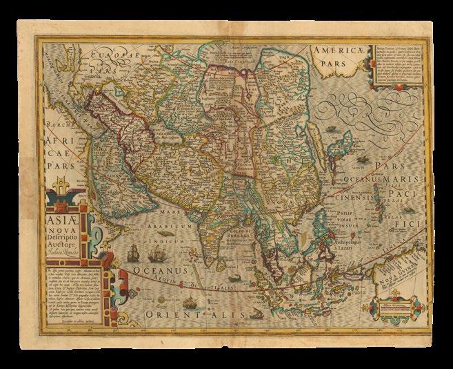
JANSSONIUS, Johannes
Indiae Orientalis Nova Descriptio.
Publication
Amstelodami, Ioannes Janssonius excudebat, [1636]
Description
Double-page engraved map, with contemporary hand-colour in outline, German text on verso, closed tear strengthened on verso.
Dimensions
510 by 610mm (20 by 24 inches).
References
Clancy, ‘The Mapping of Terra Australis’, 1995, 6.6; Schilder, ‘Australia Unveiled’, 1976, 24; Woods, National Library of Australia, ‘Mapping our World: Terra Incognita to Australia’, 2014, pages 114-116.
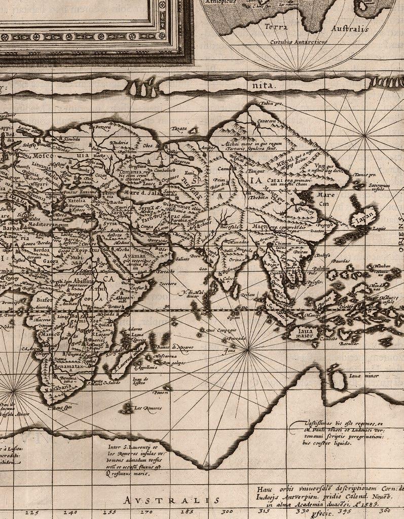
Johannes Janssonius’s map of the East Indies was first published in his ‘Atlantis Majoris Appendix’ in 1630, when it was the “first commercially available map to show any of the discoveries made in the ‘Duyfken’ in any detail” (Woods). It is an undisputed landmark in the mapping of Australia.
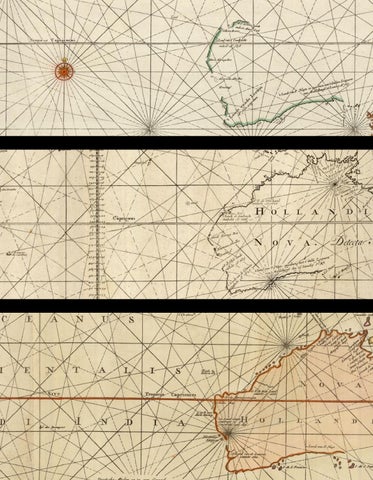
In 1606, Willem Janszoon, the captain of the ‘Duyfken’, sailed down the south coast of New Guinea and named a small piece of land “Duyfkens Eylant”, after which, just like that, he crossed Torres Strait, although he thought it a bay, and arrived on the west coast of Cape York peninsula, as far as the Arukun Wetlands, although he thought it still New Guinea.
Janszoon was probably the first European to chart any part of Australia, but the map does not show the entire route of the voyage of the ‘Duyfken’, “because it does not extend far enough south or east to include the ship’s path along the coast of the Gulf of Carpentaria. While this may have been a deliberate omission, it is more likely to be the result of cartographic convention: Janssonius’s map was framed according to an earlier map by Jodocus Hondius, ‘Insulae Indiae Orientalis’ – Islands of East India – of 1613” (Woods).

HONDIUS, Henricus
Nova Totius Terrarum Orbis Geographica Ac Hydrographica
Tabula. Auct: Henri: Hondio.
Publication
Amsterdam, Henricus Hondius 1630, but from 1633.
Description
Double-page engraved map, with German text on verso, a bit brown.
Dimensions
410 by 565mm (16.25 by 22.25 inches).
References
Clancy, ‘The Mapping of Terra Australis’, 1995, 6.2; Clancy and Richardson, ‘So they came South’, 1988, pages 72-74; Shirley, World 336.
Faced with increasing competition from the large cartographic house of Blaeu, Johannes Janssonius and his business partner Henricus Hondius set about revising the Mercator – Hondius atlas, and in particular the world map, which had remained unrevised for 35 years long years of exploration and discovery.
This brand new, double-hemisphere map of the world was published in the ‘Gerardi Mercatoris et I. Hondii’ atlas from 1633 until 1658, and is the first dated map, “1630”, to show Dutch discoveries along the northern coastline of Australia.
It is, therefore, the first commercially available map to show the full extent of Willem Janszoon’s voyage in the ‘Duyfken’. In 1606, Willem Janszoon, the captain of the ‘Duyfken’, sailed down the south coast of New Guinea and named a small piece of land “Duyfkens Eylant”, sailed across the Torres Strait, down the west coast of Cape York peninsula, as far as the Arukun Wetlands, assuming that it was still part of New Guinea.
Unlike Johannes Janssonius map, ‘Indiae Orientalis Nova Descriptio’ (1630), which shows only the New Guinea portion of Janszoon’s discoveries, the current map includes the area the ‘Duyfken’ sailed along the west coast of the Cape York peninsula. It also adds the discoveries of Jan Carstensz in command of the ‘Pera’ during his voyage of 1623, which followed the route of the ‘Duyfken’, and continued into the Gulf of Carpentaria. However, it omits, probably intentionally, the discoveries of Willem Joosten van Colster, in the ‘Arnhem’, and Dutch discoveries of the western Australian coastline of 1616 - 1627. Instead Hondius retains the “Beach” of Marco Polo, and only a vague outline for “Terra Australis”, still a mythical southern continent.
The map is more often noted for the extravagance of its decoration. The two hemispheres are surrounded by a complex border combining astronomical and physical cycles in order to link the earth in the centre to wider ideas of balance within the cosmos. The sun and moon appear in the cusps between the hemispheres. At the bottom is a representation of the continents of Africa, India and the Americas offering tribute to the enthroned Europe. At the top there is a celestial globe garlanded with fruits and flowers. In each corner are portraits of well-known cartographers: Julius Caesar, Claudius Ptolemy, Jodocus Hondius, and Gerard Mercator. Hondius has pointedly left out his contemporary Abraham Ortelius in favour of Ortelius’s competitor Mercator, and his own father who republished Mercator’s work.

BLAEU, Willem Janszoon
India quae Orientalis dicitur et Insulae Adiacentes.
Publication
Amsterdam, Willem and Joan Blaeu, 1634.
Description
Double-engraved map, with fine hand-colour wash in outline, German text on verso.
Dimensions
509 by 592mm (20 by 23.25 inches).
References
Clancy, ‘The Mapping of Terra Australis’, 1995, 6.7 (later issue); Clancy and Richardson, ‘So they came South’, 1988, page 77-79; National Library of Australia, ‘Mapping our World: Terra Incognita to Australia’, 2014, page 116; Schilder, ‘Australia Unveiled’, 1976, 40; Tooley, ‘Mapping of Australia’, 1979, 222; Suarez, ‘Early Mapping of Southeast Asia’, 1999, pages 201-202; Van der Krogt: 8400:2, second proof with the title complete but the dedication cartouche blank.
This map of the East Indies was published in the first German edition of the Blaeu family atlas, ‘Theatrum orbis terrarium, sive Atlas Novus’, 1634-1635, it is an example of the second proof state, with cartouches, but without a dedication and some topographical details, such as mountain ranges and forests. The finished map, with dedication, appeared in Blaeu’s two-volume atlas from 1635 onward and was only revised in 1664.
Importantly, it is the second commercially available map to show the full extent of Willem Janszoon’s voyage in the ‘Duyfken’, preceded by the world map of Henricus Hondius of 1630 [1633] (see item 40), and the first to include details of the Dutch discoveries on the northern west coast of Australia. In 1606, Willem Janszoon, the captain of the ‘Duyfken’, sailed down the south coast of New Guinea and named a small piece of land “Duyfkens Eylant”, sailed across the Torres Strait, down the west coast of Cape York peninsula, as far as the Arukun Wetlands, assuming that it was still part of New Guinea.
Unlike Johannes Janssonius map, ‘Indiae Orientalis Nova Descriptio’ (1630), which shows only the New Guinea portion of Janszoon’s discoveries, the current map includes the area the ‘Duyfken’ sailed along the west coast of the Cape York peninsual. It also adds the discoveries of Jan Carstensz in command of the ‘Pera’ during his voyage of 1623, which followed the route of the ‘Duyfken’, and continued into the Gulf of Carpentaria. However, it omits, probably intentionally, the discoveries of Willem Joosten van Colster, in the ‘Arnhem’.
Nevertheless, at the centre of the lower edge of the map is the fragmented coastline of northern Western Australia: “G.F. de Wits landt”, named for Gerrit Fredericsz de Wit and his voyage of 1628; and “’t Landt van ‘D Eendracht’”, referencing Dirk Haartog’s first landfall in 1616 at Ashburton River. Other discoveries in southern Western Australia are omitted, probably only because they are beyond the range of map’s parameters.
As official cartographer to the VOC Willem Blaeu, from 1633, would have been privy to all this information almost as soon as it was known to the sailors, however, so stringent were the VOC’s secrecy laws, that he withheld his knowledge from the public for nearly twenty-five years, presumably until the Dutch had decided quite how little advantage the barren landscape would be to them. If only they had been able to scratch the surface!

BLAEU, Willem Janszoon
India quae Orientalis dicitur et Insulae Adiacentes.
Publication Amsterdam, Willem and Joan Blaeu, [1643-50].
Description
Double-engraved map, with contemporary hand-colour in part and in outline, French text to verso.
Dimensions
510 by 590mm (20 by 23.25 inches).
References
Clancy, ‘The Mapping of Terra Australis’, 1995, 6.7; Clancy and Richardson, ‘So they came South’, 1988, page 77-79; National Library of Australia, ‘Mapping our World: Terra Incognita to Australia’, 2014, page 116; Schilder, ‘Australia Unveiled’, 1976, 40; Tooley, ‘Mapping of Australia’, 1979, 226; Suarez, ‘Early Mapping of Southeast Asia’, 1999, pages 201-202; Van der Krogt: 8400:2.
This map of the East Indies was first published in various proof states in the first German edition of the Blaeu family atlas, ‘Theatrum orbis terrarium, sive Atlas Novus’, 1634-1635. The finished map, with dedication, appeared in Blaeu’s two-volume atlas from 1635 onward and was only revised in 1664.

COLOM, Jacob Aertsz
Nova Totius Terrarum Orbis Geographica Ac Hydrographica
Tabula. Auct. Iacobus Colom.
Publication Amsterdam, Jacob Colom, c1650.
Description
Double-page engraved map, lower margin repaired.
Dimensions
430 by 454mm (17 by 17.75 inches).
References
Clancy, ‘The Mapping of Terra Australis’, 1995, 6.5; Shirley World 378 (plate 283 for Allard), 381 (Jacob Colom), 395 (Arnold Colom), 421 (de Wit); Suarez, ‘Early Mapping of Southeast Asia’, 1999, page 209.
This double-hemisphere map of the world presents as a bit of a conundrum. Shirley, giving it a dated of c1650, states “It is not certain when this world map was prepared but it seems to have been issued separately before being put aside and then used in some copies of his later sea atlas ‘Werelts-WaterDeal’ of 1663, where several of the charts are dated 1656”. The British Library example is given a tentative date of “1655?”
The map is very similar in style and geography to Henricus Hondius’s ‘Nova Totius Terrarum Orbis Geographica Ac Hydrographica Tabula. Auct: Henri: Hondio’ (see item 40) (1633, Shirley 336). However, Colom has also borrowed from Hugo Allard’s ‘Nova Totius Terrarum Orbis Geographica ac Hydrographica Tabula. Auct. Hugo Allart’ (c1650 Shirley 378): the discoveries of Willem Janszoon and Jan Carstensz in northern Australia are recorded, just as in Hondius’s map, but Colom has “improved” on Hondius by following Allard and adding a sketchy outline of Western Australia, with accounts of Dutch discoveries there, but not to the full extent of Abel Tasman’s voyages of 1642-1644. Colom then copies all the elements of Allard’s border and applies them to his own map. The spandrels in both maps are filled with portrait medallions of famous geographers and representations of classical deities, who also personify the four elements: Apollo (fire), Artemis (air), Gaia (earth) and a river god (water).
The cartography is then used by Jacob’s son Arnold for his world map, ‘Nova Delineato Totius Orbis Terrarum…’ (c1655, Shirley 395), but he has created a whole new border. Arnold’s map appears in his ‘ZeeAtlas’ from 1654 – 1658, and some examples of the ‘Werelts-Water-Deal’ of 1663.
At some point, “the map came into the hands of Frederick de Wit who reduced its size by re-engraving a new title ‘Nova Totius Terrarum Orbis Tabula’ below the original top border” (1660 Shirley 421). De Wit has borrowed some of the elements from the border of Hugo Allard and Jacob Colom’s map, with a similar sun within a zodiac circle between swags of fruit and foliage at the upper edge, but the overall effect is superior in every way to the earlier maps.

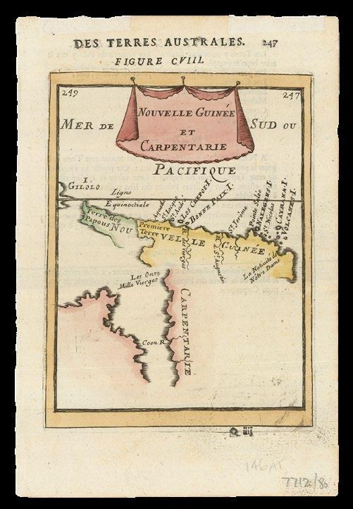
MANESSON-MALLET, Allain Nouvelle
Guinee et Carpentarie.
Publication Paris, Chez Denis Thierry, Rue St Jacques, 1683.
Description
Full-page engraved map, with fine handcolour in full, French text on verso
Dimensions 210 by 140mm (8.25 by 5.5 inches).