5 minute read
“TERRA AUSTRALIS” AS VAST AND STANDARDISATION

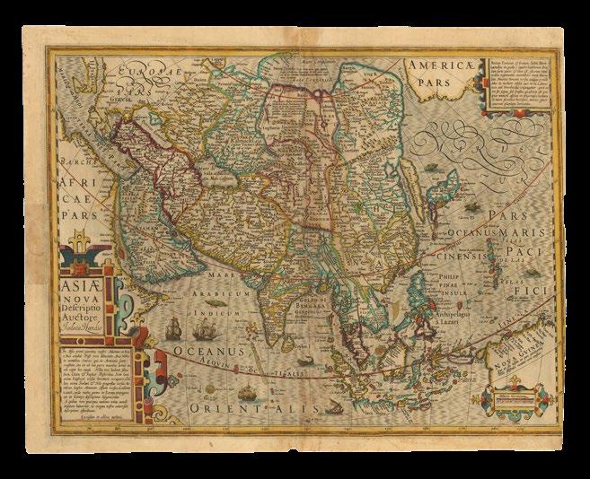
ORTELIUS, Abraham
Asiae Nova Descriptio.
Publication
Antwerp, Christopher Plantin, 1580, or 1589.
Description
Double-page engraved map, with contemporary hand-colour in full, German text on verso, toned, small hole to “Nova Guinea”.
Dimensions
395 by 525mm (15.5 by 20.75 inches).
References
Clancy, ‘The Mapping of Terra Australis’, 1995, 1.2; Suarez, ‘Early Mapping of Southeast Asia’, 1999, pages 164 – 169; Van den Broecke, ‘Ortelius Atlas Maps: An Illustrated Guide’, 2011, Ort 7.1 1580/1589G3.
Second state of Abraham Ortelius’s map of the whole of Asia, distinguished by the removal of “Cum priuilegio” in the lower left corner; “La farfana” replaces “La Farfana” in the upper right-hand corner in the sea near Japan; and the town “Ara” above “Aden” has vanished.
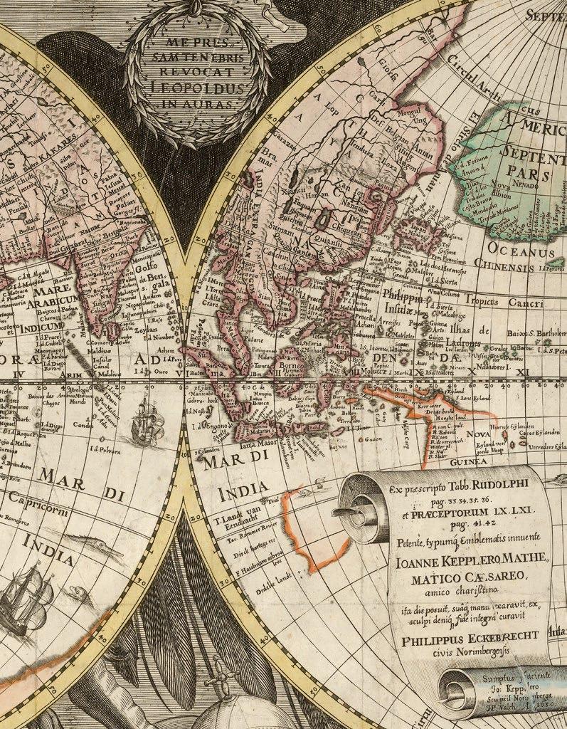
The map is a reduction of Ortelius’s own separately-published map of Asia (1567). In the 1567 map Ortelius explained that his map was based on the work of Giacomo Gastaldi, whose own work was in turn supposedly based on the Muslim scholar “Taqwim Albudan”, which was in reality the title of an archaic Arab geographic dictionary. He also benefited from information from the voyage of the Spanish explorer Miguel López de Legazpi, who reached the Philippines from Mexico in 1565. The island to the north of New Guinea, “La Barbuda”, was discovered by the expedition, who named the island in honour of the bearded men they found there. New Guinea in general has been improved, with a few islands off the coast called “Cainan”, which is West Papua.
This map and the map of southeast Asia in the ‘Theatrum’ were the first to definitely map Taiwan, labelled “I Fermosa”. Ortelius has improved upon the position of the Moluccas, possibly thanks to a letter he received on the subject from the French cartographer Guillaume Postel in 1567, who complained that Portuguese mapmakers had disseminated false coordinates for the islands. Japan, however, is drawn after Portuguese sources. Interestingly, what is shown of New Guinea appears as an island, quite distinct from the glimpse of “Terrae Australis” in the lower righthand corner.
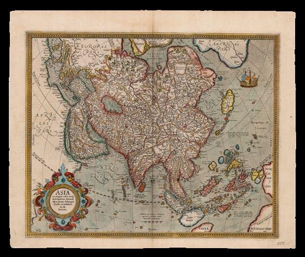
ORTELIUS, Abraham
Indiae Orientalis Insularumque Adiacientium Typus.
Publication
Antwerp, Christopher Plantin, 1587.
Description
Double-page engraved map, with contemporary hand-colour in full, German text on verso, browned, short tears with minor losses to oxidised patches.
Dimensions
397 by 535mm (15.75 by 21 inches).
References
Clancy, ‘The Mapping of Terra Australis’, 1995; Suarez, ‘Early Mapping of Southeast Asia’, 1999, pages 164-167; Van den Broecke, ‘Ortelius Atlas Maps: An Illustrated Guide’, 2011, 166.1 1580/1589G84.
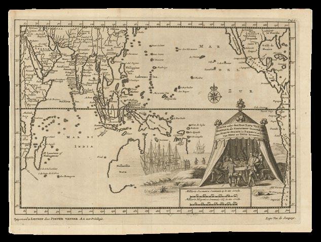
Generally speaking, Abraham Ortelius’s map of Southeast Asia follows the geography of Gerard Mercator’s large wall-map of the world of 1569. Nevertheless, along with Ortelius’s companion map ‘Asiae Nova Descriptio’, it is the first published to definitely map Formosa, although as a group of islands, rather than one; and they both improve enormously on preceding Italian maps in regards to the highly sought after, and fiercely contested, Moluccas, or “Spice Islands”.
There are hundreds of islands in the group, but Ortelius depicts only a very select group, which feature in the more than two-hundred years of colonial strife that was the European spice trade, and even adds fuel to fire by literally waving a banner over them in his map: “Insulæ Moluccæ ob maximam aromatum copiam, quam per totum terrarû orbem transferunt, 5.sunt, iuxta Gilolo nempe, Tarenate, Tidore, Motir, Machia et Bachia” - Of the famous Moluccas islands there are next to Gilolo five, exporting all over the world a great abundance of fragrant spices, namely Tarenate, Tidore, Motir, Machia and Bachia. Until the eighteenth century, these rain-forested islands were the only obtainable source of cloves, nutmeg, and mace.
Perhaps to counterbalance this open invitation, Ortelius has added a few visual caveats: to the east a galleon is under attack from two ferocious sea-monsters, in imminent danger of foundering; and beneath them, two mermaids are preparing to lure any unwary survivors to a an uncertain fate.
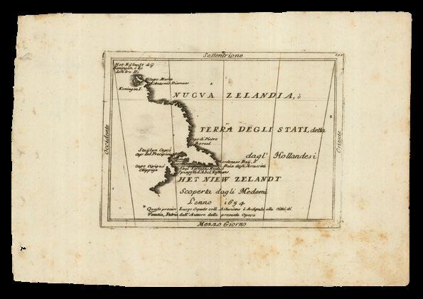
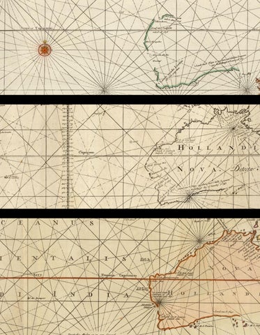
In the bottom right-hand corner “Nova Guinea” makes an appearance, and since the inference is that it continues beyond the neatline, Ortelius nicely sidesteps the question of whether it is part of “Terra Australis”, or an island, and confuses things further, by adding a caption: “NOVA GVINEA quam Andreas Corsalis Ter:ram Piccinaculi appellare vi:detur. An insula sit, an pars continentis Australis incer:tum est” - New Guinea, which seems to be called Piccinaculusland by Andreas Corsalis. Whether this is an island or part of the South Land is uncertain.
Like Mercator before him, Ortelius includes a tantalizing glimpse of the mythical coastal kingdom of “Beach” on a promontory, superficially similar to what would be known as Cape York on the northern coast of Australia, of the vast south land of “Terra Australis”. According to Suarez, the “error can be traced to the 1532 ‘Novus Orbis’ of Huttich, which was published in Paris with the map of Fine, and in Basle with the map of Munster/Holbein. This volume contained the text of Marco Polo’s journey, but it mistakenly corrupts Polo’s “Lochac” to “Boeach”, which in turn was shortened to “Beach””. An error Mercator duplicated on this on his large world map of 1569, and which persisted on maps, well into the 1600s.

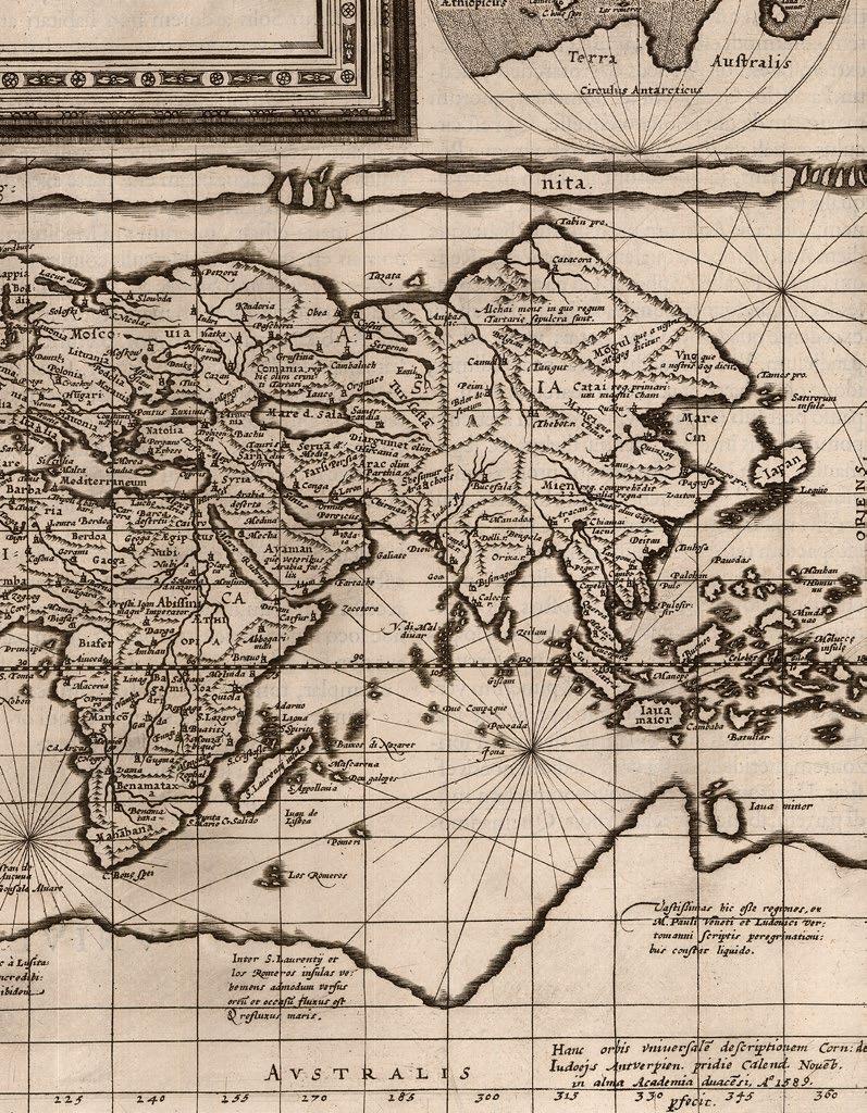
ORTELIUS, Abraham
Tartariae Sive Magni Chami Regni typus.
Publication
Antwerp, Christopher Plantin, ??? 1570.
Description
Double-page engraved map, Latin text to verso.
References
Literature: Van den Broecke, ‘Ortelius Atlas Maps: An Illustrated Guide’, 2011; Vn der Krogt: 8050:31.
Ostensibly, a map of Tartary, or the Realms of the Great Khan, from the 1570 Latin edition of Abraham Ortelius’s ‘Theatrum Orbis Terrarum’. The map is as resplendent as the Great Khan, “Magnus Cham… maximus Asie princeps”, himself, who appears crowned and enthroned before his tent. His territory borders Russia in the northwest, whose emperor is twice as large, and appears battle ready before his own even more splendid tent, daring the Khan to invade; and the lands of north of the Himalayas, encompassing the route of Marco Polo from Kashgar to Beijing, via Xanadu, the summer residence of Kublai Khan.
Incidentally, when first printed, this map was also the earliest obtainable to name California. The mythical Strait of Anian is shown between Asia and America, which contains a caption: “Oceanus Scythicus, dulcis est Plinio auctore, qui multas in eo insulas esse dicit, ut etiam M: Paul: Vene:tus : sed neuter neg’z situm neg’z numero tradit” – “The Scythian Ocean, is sweet, as Pliny wrote, with a multitude of islands, as he said, and as Marco Polo also says, but neither of them says where, or how many.

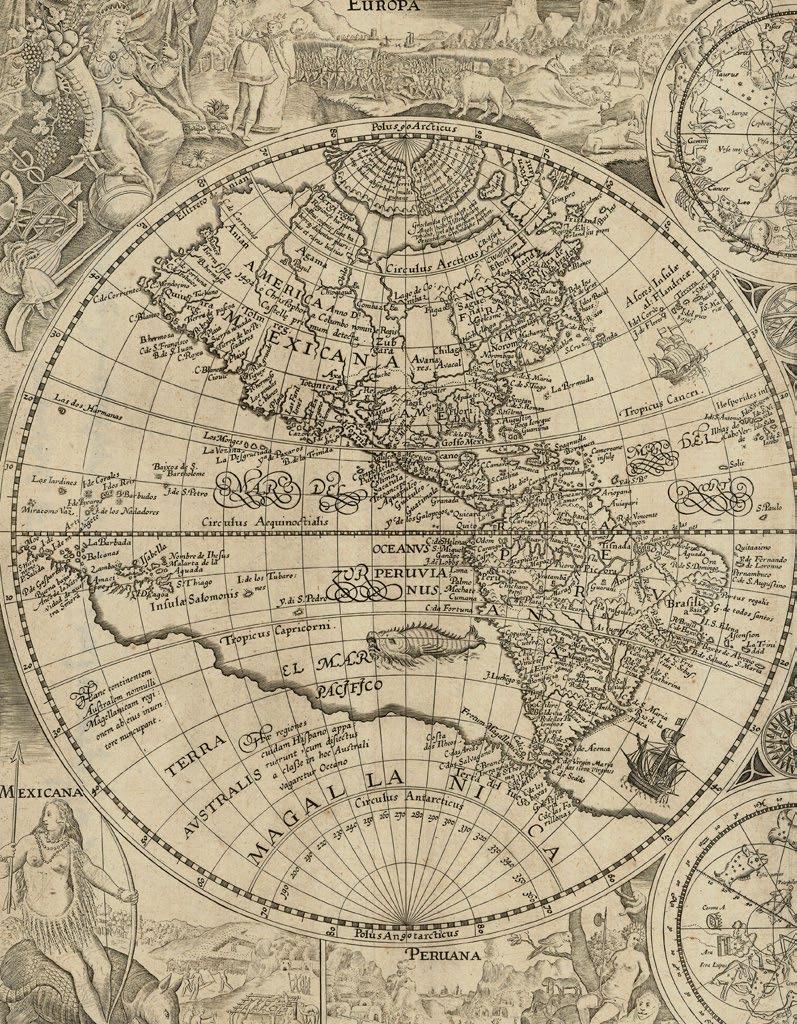
MERCATOR, Rumold
Orbis Terrae Compendiosa
Descriptio Quam ex Magna Universali Gerardi Mercatoris. Domino Richardo Gartho, Geographic ac ceterarum bonarum artium amatori ac fautori summo, in veteris amicitie ac familiaritatis memoria
Rumoldus Mercator fieri curabat
A.o M.D. Lxxxvii.
Publication
Geneva, Eustathius Vignon, 1587.
Description
Double-page engraved map, lower left corner renewed with some manuscript facsimile to the neatline.
Dimensions
305 by 545mm (12 by 21.5 inches).
References
Clancy, ‘The Mapping of Terra Australis’, 1995, 5.11, and page 70; Shirley, ‘The mapping of the world: early printed world maps, 1472-1700’, 2001, 157.
This double-hemisphere map of the world is a reduced version of Gerard Mercator’s revolutionary wall map of the world (1569), and was first published in Strabo’s ‘…Geographicarum libr XVII’, with text beneath the map headed “Lectori S.P.”, and without text on the verso. It may have also been published separately, and in the final part of Mercator’s atlas, before being included in Rumold Mercator’s complete five part edition of the atlas from 1595. However, the Mercator family were beaten to the post, in popularizing (and capitalizing on) this modern world view, by Abraham Ortelius, who included it as a simplified single sheet map in his atlas of the world, ‘Theatrum Orbis Terrarum’ (1570). California shown as part of the mainland, there is the distinctive bulge in South America, and the kingdoms of Beach, Lucach and Maletur are shown as part of the mythical southern continent “Terra Australis”, which is shown as an entirely separate landmass.


MERCATOR, Gerard; and Henricus HONDIUS
Asia ex magna orbis terre descriptione Gerardi Mercatoris desumpta studio et industria G.M. Iunioris.
Publication
Amsterdam, Henricus Hondius, [1609-1619].
Description
Double-page engraved map, with fine handcolour in full, French text on verso.
Dimensions
430 by 530mm (17 by 20.75 inches).
References
Clancy, ‘The Mapping of Terra Australis’, 1995, 5.11, and page 70; Shirley, ‘The mapping of the world: early printed world maps, 1472-1700’, 2001, 157.