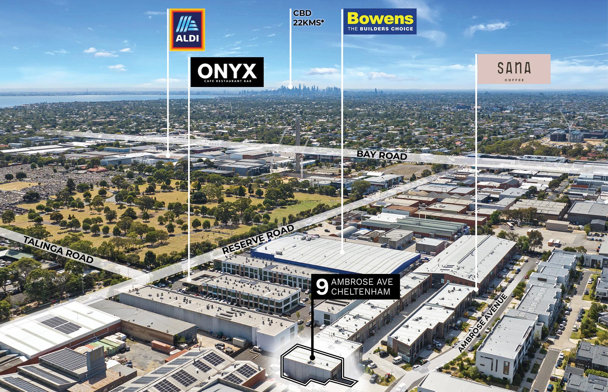
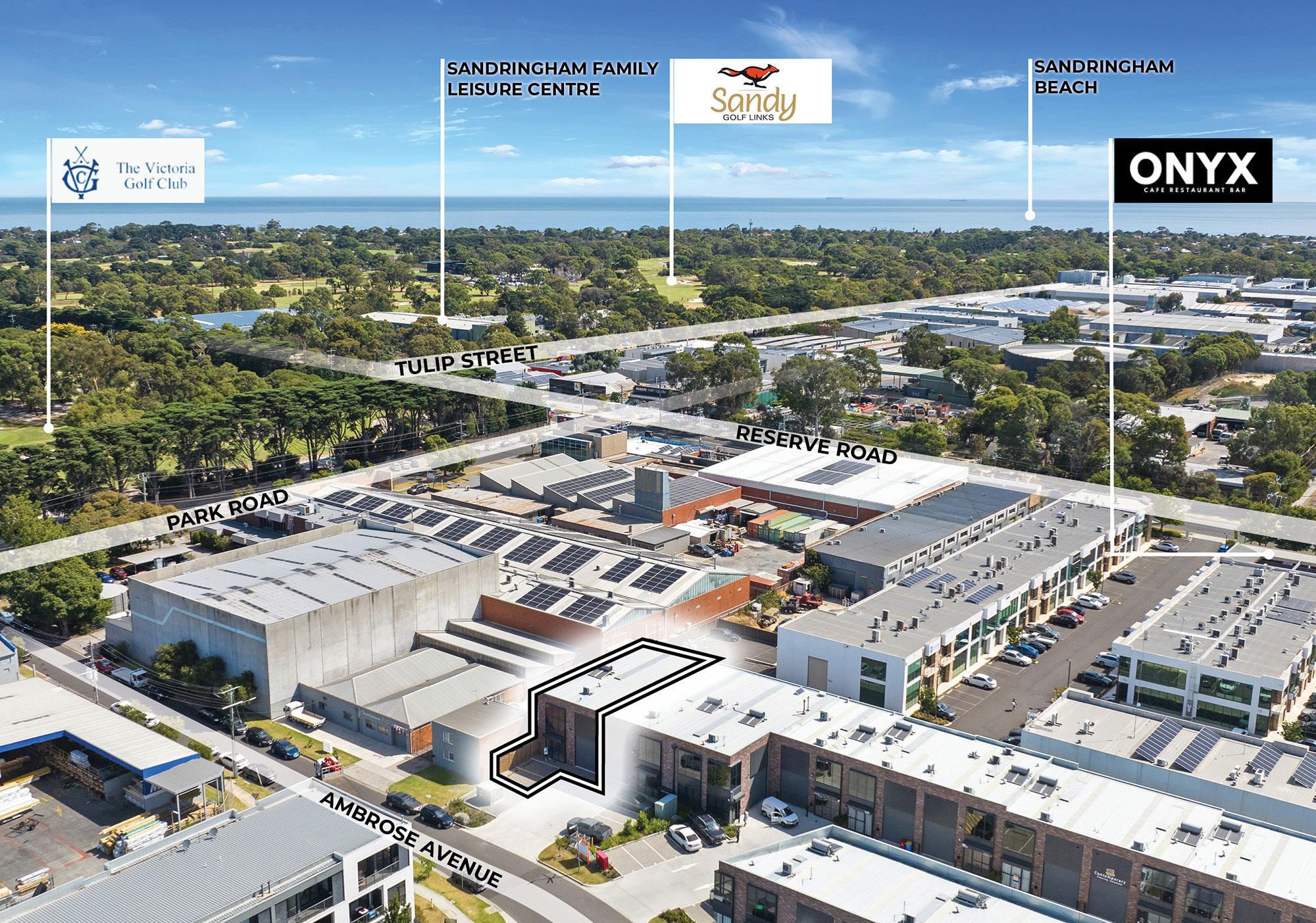
All signs point to: Cheltenham
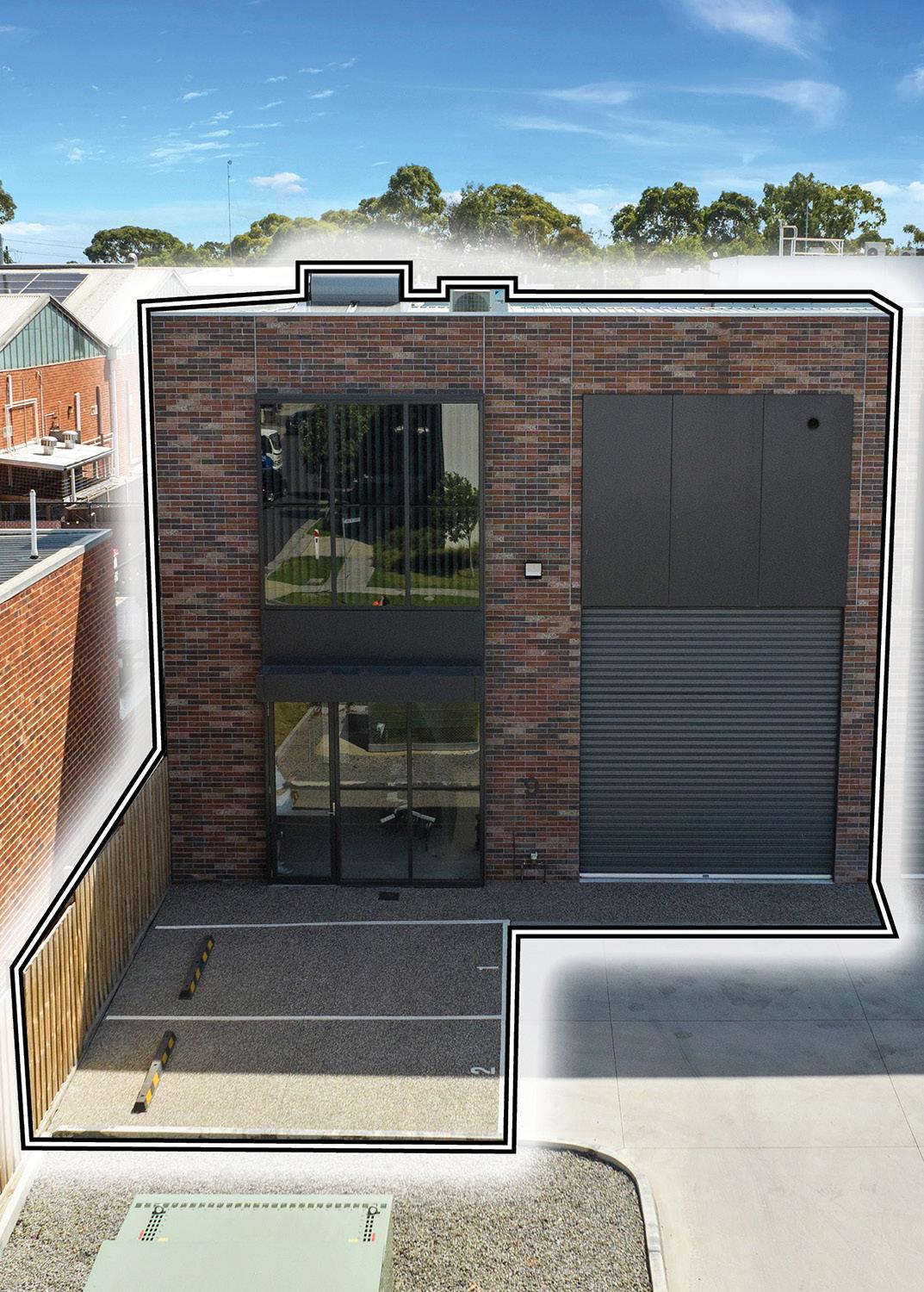
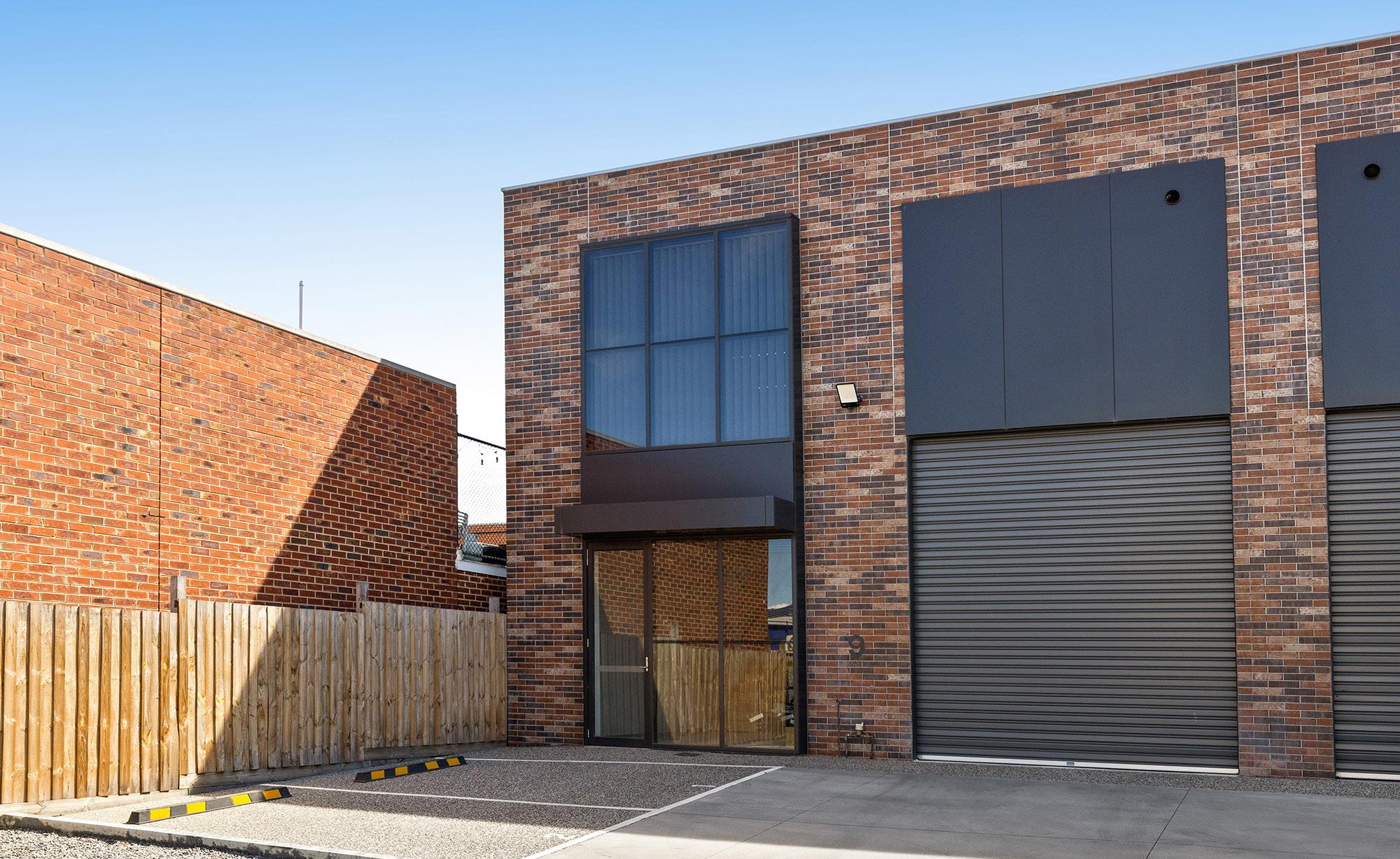
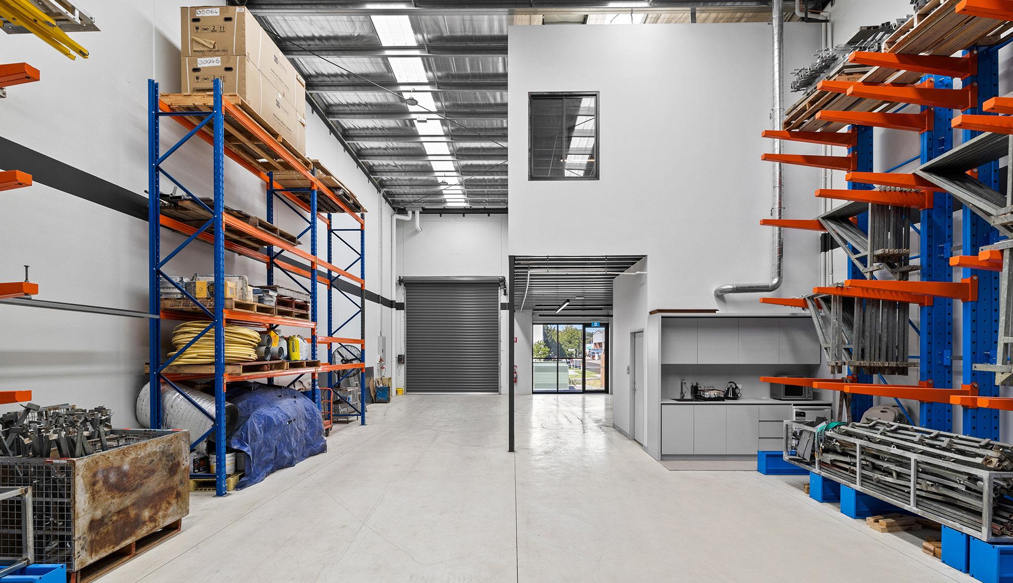
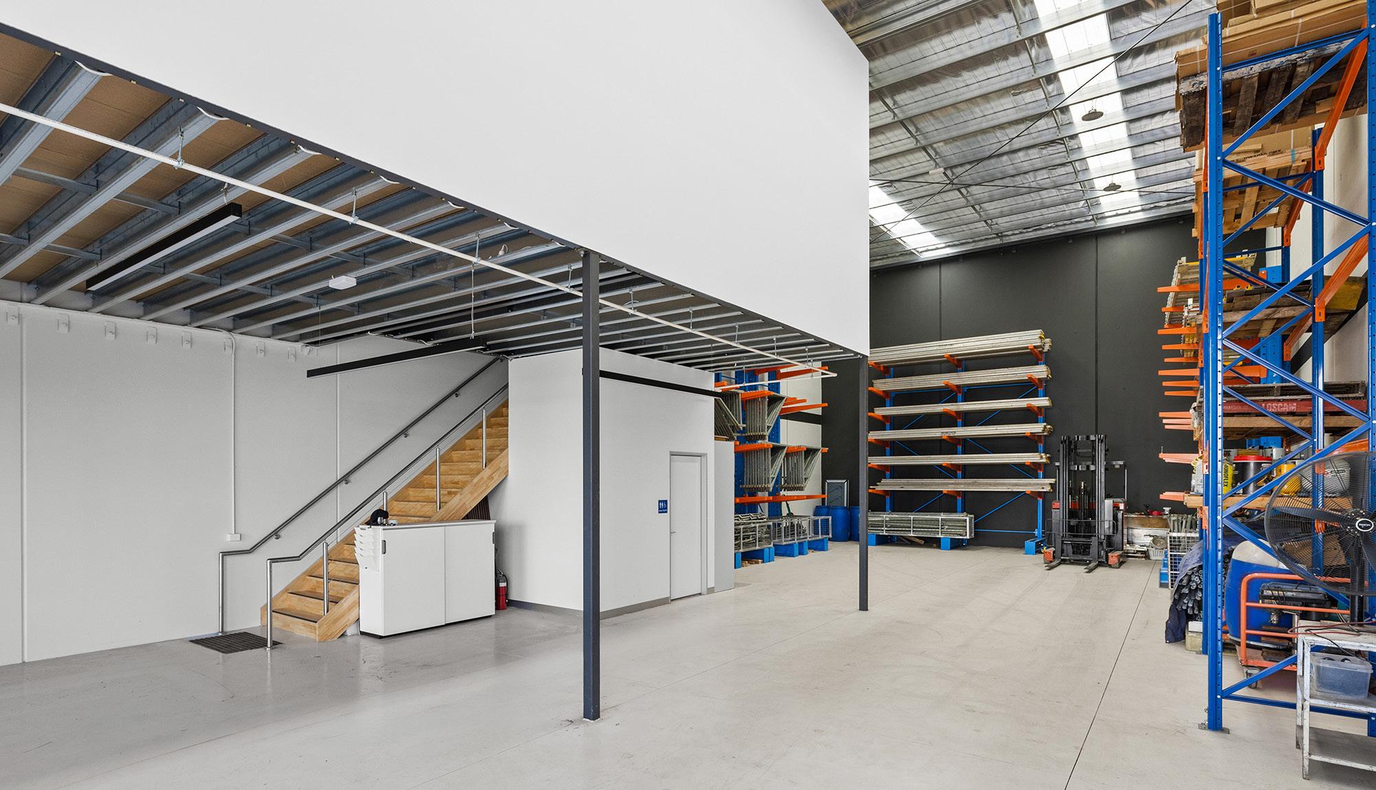
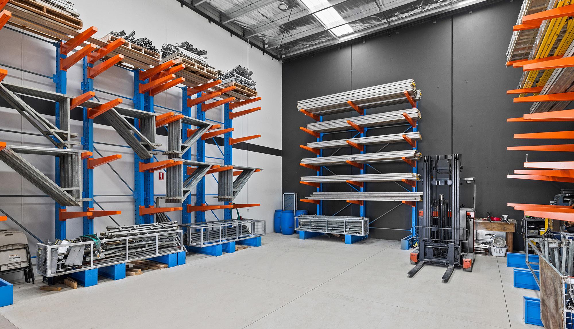
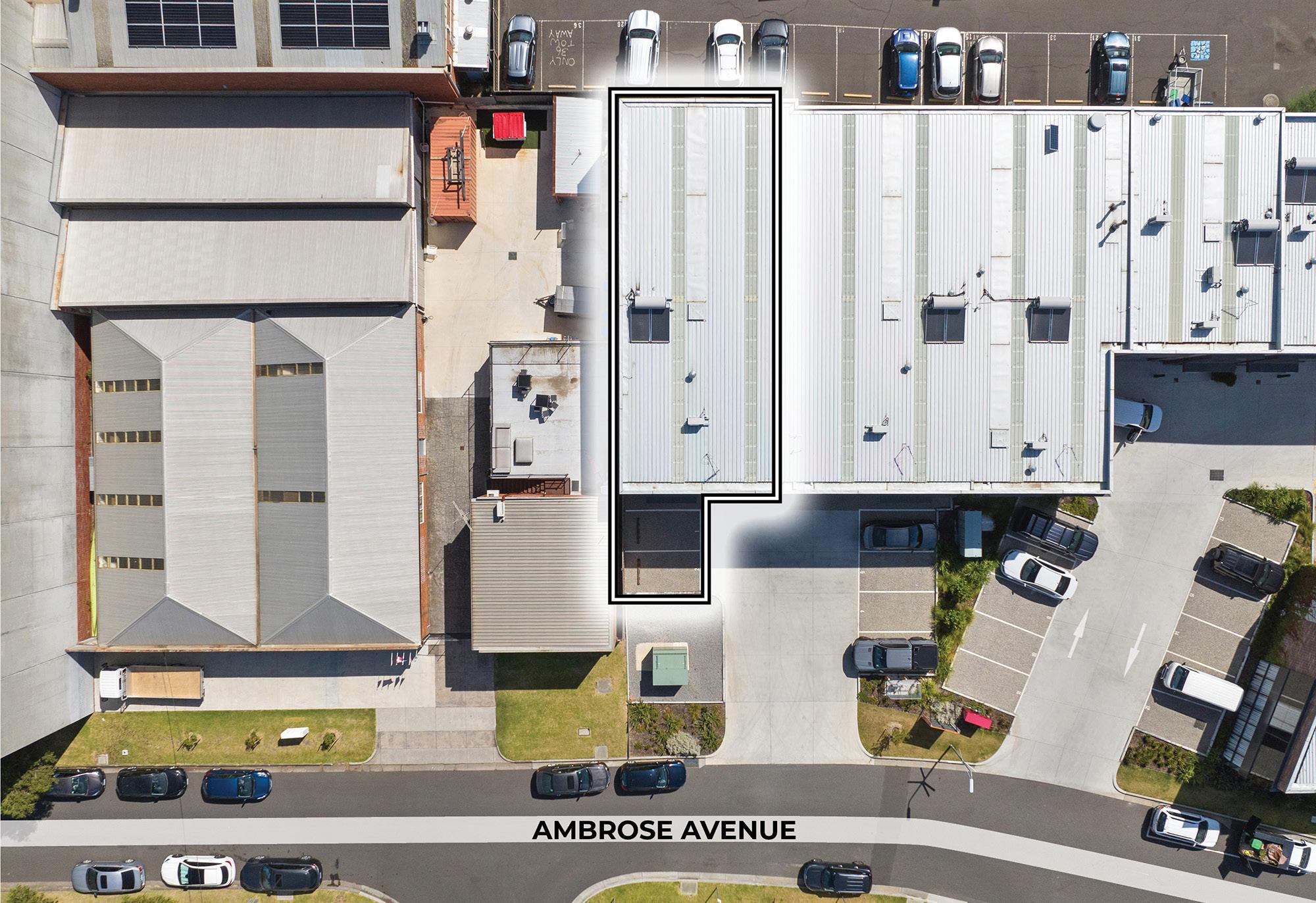
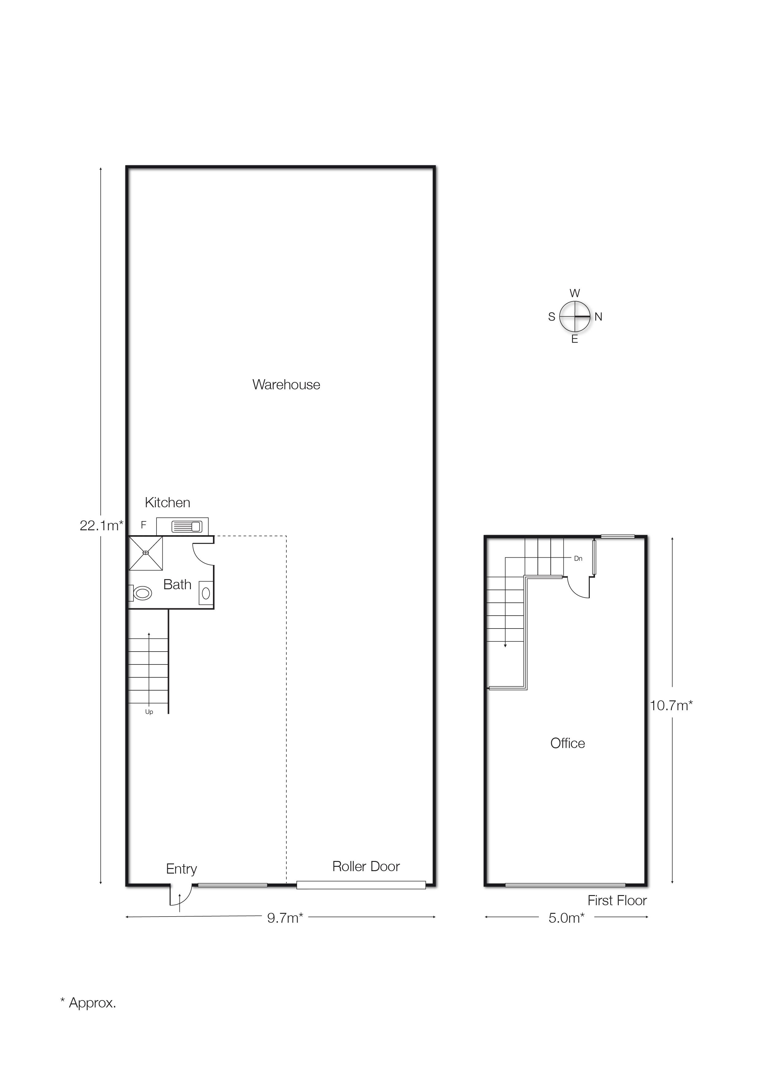
In a market where purpose-built, architecturally designed warehouses are few and far between, 9 Ambrose Avenue will raise the eyebrows of both owner-occupiers and local investors who don’t drag their feet.
Cheltenham shows a median house price of approximately $1.21 million, with annual growth around 0.92%, and a rental yield of 3.16%. Notably, the commercial sector features a diverse range of properties, including offices, warehouses, and retail spaces, with sizes varying from 31 to over 1,170 sqm*. This variety, coupled with its proximity to key flagships like Southland Shopping Centre, Moorabbin Airport, and the Direct Factory Outlets, positions Cheltenham as a sought-after destination for businesses seeking both space and strategic location.
This property is aimed squarely at businesses eager to own their own industrial space. With demand for top-tier properties outpacing supply, competition is fierce. Perfectly suited for everything from e-commerce and import/export to trades and wholesale operations, the solid foundation is ready for customisation to suit any business need, ensuring long-term value and flexibility.
ShownontheplanningschememapasB3Z,B4ZorC2Z
Purpose
ToimplementtheMunicipalPlanningStrategyandthePlanningPolicyFramework
To encourage commercial areas for offices, appropriate manufacturing and industries, bulky goodsretailing,otherretailuses,andassociatedbusinessandcommercialservices
Toensurethatusesdonotaffectthesafetyandamenityofadjacent,moresensitiveuses.
Section 1 - Permit not required Use
Art and craft centre
Art gallery
Automated collection point
Cinema
Cinema based entertainment facility
Food and drink premises
Industry (other than Materials recycling and Transfer station)
Must meet the requirements of Clause 52.13-3 and 52.13-5.
The gross floor area of all buildings must not exceed 50 square metres.
The site must adjoin, or have access to, a road in a Transport Zone 2 or a Transport Zone 3.
The site must adjoin, or have access to, a road in a Transport Zone 2 or a Transport Zone 3.
The leasable floor area must not exceed 100 square metres.
Must not be a purpose listed in the table to Clause 53.10 with no threshold specified.
The land must be at least the following distances from land (not a road) which is in anActivity Centre Zone, Capital City Zone, Commercial 1 Zone, Docklands Zone, residential zone or Rural Living Zone, land used for a hospital, an education centre or a corrective institution or land in a Public Acquisition Overlay to be acquired for a hospital, an education centre or a corrective institution:
The threshold distance, for a purpose listed in the table to Clause 53.10.
30 metres, for a purpose not listed in the table to Clause 53.10.
Must not:
Exceed a fire protection quantity under the Dangerous Goods (StorageandHandling)Regulations2022.
Require a notification under the Occupational Health and Safety Regulations2017
Require a licence under the Dangerous Goods (Explosives) Regulations2011
Require a licence under the Dangerous Goods (HCDG) Regulations2016.
Use Condition
Informal outdoor recreation
Mail centre
Museum
Office
Postal agency
Railway
Restricted retail premises
Shop (other thanAdult sex product shop, Restricted retail premises and Supermarket)
Supermarket
Must adjoin, or be on the same land as, a supermarket when the use commences.
The combined leasable floor area for all shops adjoining or on the same land as the supermarket must not exceed 500 square metres.
The site must adjoin, or have access to, a road in a Transport Zone 2 or a Transport Zone 3.
The leasable floor area must not exceed 1800 square metres.
The site must adjoin, or have access to, a road in a Transport Zone 2 or a Transport Zone 3.
Must be on land within the City of Greater Geelong or within an urban growth boundary in metropolitan Melbourne.
Trade supplies
Tramway
Warehouse (other than Mail centre)
Must not be a purpose listed in the table to Clause 53.10 with no threshold distance specified.
The land must be at least the following distances from land (not a road) which is in anActivity Centre Zone, Capital City Zone, Commercial 1 Zone, Docklands Zone, residential zone or Rural Living Zone, land used for a hospital, an education centre or a corrective institution or land in a Public Acquisition Overlay to be acquired for a hospital, an education centre or corrective institution:
The threshold distance, for a purpose listed in the table to Clause 53.10.
30 metres, for a purpose not listed in the table to Clause 53.10.
Must not:
Exceed a fire protection quantity under the Dangerous Goods (StorageandHandling)Regulations2022.
Require a notification under the Occupational Health and Safety Regulations2017
Use
Any use listed in Clause 62.01
Condition
Require a licence under the Dangerous Goods (Explosives) Regulations2011
Require a licence under the Dangerous Goods (HCDG) Regulations2016.
Must meet the requirements of Clause 62.01.
Section 2 - Permit required
Use
Adult sex product shop
Agriculture (other thanAnimal production andApiculture)
Caretaker's house
Container deposit scheme centre
Education centre
Grazing animal production
Leisure and recreation (other than Informal outdoor recreation, Major sports and recreation facility and Motor racing track)
Materials recycling
Place of assembly (other thanArt gallery, Carnival, Cinema, Cinema based entertainment facility, Circus and Museum)
Residential hotel
Retail premises (other than Food and drink premises, Postal agency, Restricted retail premises, Supermarket and Trade supplies)
Supermarket – if the Section 1 conditions are not met
Condition
Must be at least 200 metres (measured by the shortest route reasonably accessible on foot) from a residential zone, land used for a hospital, primary school or secondary school or land in a PublicAcquisition Overlay to be acquired for a hospital, primary school or secondary school.
The leasable floor area must not exceed 1800 square metres unless on land within the City of Greater Geelong or within an urban growth boundary in metropolitan Melbourne.
The site must adjoin, or have access to, a road in a Transport Zone 2 or aTransport Zone 3.
34 02-2
15/07/2013 VC100
Use
Transfer station (other than Automated collection point and Container deposit scheme centre )
Condition
The land must be at least 30 metres from land (not a road) which is in anActivity Centre Zone, Capital City Zone, Commercial 1 Zone, Docklands Zone, residential zone or Rural Living Zone, land used for a hospital, an education centre or a corrective institution or land in a PublicAcquisition Overlay to be acquired for a hospital, an education centre or a corrective institution.
34.02-3
31/07/2018 VC148
Utility installation (other than Minor utility installation and Telecommunications facility)
Any other use not in Section 1 or 3
Section 3 - Prohibited
Use
Accommodation (other than Caretaker's house and Residential hotel)
Animal production (other than Grazing animal production)
Hospital
Major sports and recreation facility
Motor racing track
Use of land
Ausemustnotdetrimentallyaffecttheamenityoftheneighbourhood,includingthroughthe:
Transportofmaterials,goodsorcommoditiestoorfromtheland.
Appearanceofanybuilding,worksormaterials
Emission of noise, artificial light, vibration, smell, fumes, smoke, vapour, steam, soot, ash, dust,wastewater,wasteproducts,gritoroil
Subdivision
Apermitisrequiredtosubdivideland.
VicSmart applications
Subject to Clause 71.06, an application under this clause for a development specified in Column 1 is a class of VicSmart application and must be assessed against the provision specified in Column2
Class of application
Subdivide land to realign the common boundary between 2 lots where:
The area of either lot is reduced by less than 15 percent.
The general direction of the common boundary does not change.
Information requirements and decision guidelines
Clause 59.01
of application
Subdivide land into lots each containing an existing building or car parking space where:
The buildings or car parking spaces have been constructed in accordance with the provisions of this scheme or a permit issued under this scheme.
An occupancy permit or a certificate of final inspection has been issued under the Building Regulations in relation to the buildings within 5 years prior to the application for a permit for subdivision.
Subdivide land into 2 lots if:
The construction of a building or the construction or carrying out of works on the land:
– Has been approved under this scheme or by a permit issued under this scheme and the permit has not expired.
– Has started lawfully
The subdivision does not create a vacant lot.
59.02
Clause 59.02
34.02-4
01/12/2023 VC217
Buildings and works
Apermitisrequiredtoconstructabuildingorconstructorcarryoutworks. Thisdoesnotapplyto:
Theinstallationofanautomatictellermachine
Analterationtoanexistingbuildingfaçadeprovided:
– Thealterationdoesnotincludetheinstallationofanexternalrollershutter.
– Atleast80percentofthebuildingfacadeatgroundfloorlevelismaintainedasanentryor windowwithclearglazing
Anawningthatprojectsoveraroadifitisauthorisedbytherelevantpubliclandmanager
VicSmart applications
Subject to Clause 7106, an application under this clause for a development specified in Column 1 is a class of VicSmart application and must be assessed against the provision specified in Column2
Class of application
Construct a building or construct or carry out works with an estimated cost of up to $500,000 where the land is not:
Within 30 metres of land (not a road) which is in a residential zone.
Used for a purpose listed in the table to Clause 53.10.
Used for anAdult sex product shop.
Information requirements and decision guidelines
59.04
Clause
Clause
34.02-5
14/01/2025 VC237
Maintenance
All buildings and works must be maintained in good order and appearance to the satisfaction of theresponsibleauthority.
Application requirements
Use
Anapplicationtouselandmustbeaccompaniedbythefollowinginformation,asappropriate:
Thepurposeoftheuseandthetypesofactivitieswhichwillbecarriedout.
The likely effects, if any, on adjoining land, including noise levels, traffic, the hours of delivery and despatch of goods or materials, hours of operation and light spill, solar access andglare
Themeansofmaintainingareasnotrequiredforimmediateuse
Ifanindustryorwarehouse:
– Thetypeandquantityofgoodstobestored,processedorproduced.
– Whether a Development Licence, Operating Licence, Permit or Registration is required fromtheEnvironmentProtectionAuthority
– Whether a notification under the Occupational Health and Safety Regulations 2017 is required, a licence under the Dangerous Goods Act 1985 is required, or a fire protection quantity under the Dangerous Goods (Storage and Handling) Regulations 2022 is exceeded.
– The likely effects on adjoining land, including air-borne emissions and emissions to land andwater.
Building and works
An application to construct a building or construct or carry out works must be accompanied by thefollowinginformation,asappropriate:
Aplandrawntoscalewhichshows:
– Theboundariesanddimensionsofthesite.
– Adjoiningroads.
– Thelocation,heightandpurposeofbuildingsandworksonadjoiningland.
– Relevantgroundlevels
– Thelayoutofexistingandproposedbuildingsandworks
– Alldriveway,carparkingandloadingareas
– Proposedlandscapeareas.
– Allexternalstorageandwastetreatmentareas.
– Areasnotrequiredforimmediateuse.
Elevationdrawingstoscaleshowingthecolourandmaterialsofallbuildingsandworks
Constructiondetailsofalldrainageworks,driveways,vehicleparkingandloadingareas
Alandscape layout which includes the description of vegetation to be planted, the surfaces to be constructed, site works specification and method of preparing, draining, watering and maintainingthelandscapearea.
34.02-6
31/07/2018
VC148
Exemption from notice and review
An application to subdivide land or construct a building or construct or carry out works is exempt from the notice requirements of section 52(1)(a), (b) and (d), the decision requirements of section 64(1), (2) and (3) and the review rights of section 82(1) of the Act This exemption does not apply to land within 30 metres of land (not a road) which is in a residential zone, land used for a hospital or an education centre or land in a PublicAcquisition Overlay to be acquired forahospitaloraneducationcentre.
34.02-7
31/07/2018
VC148
Decision guidelines
General
Before deciding on an application, in addition to the decision guidelines in Clause 65, the responsibleauthoritymustconsider,asappropriate:
TheMunicipalPlanningStrategyandthePlanningPolicyFramework.
Theinterfacewithadjoiningzones,especiallytherelationshipwithresidentialareas.
Use
Theeffectthatexistingusesmayhaveontheproposeduse.
Thedrainageoftheland.
Theavailabilityofandconnectiontoservices.
Theeffectoftraffictobegeneratedonroads
Theinterimuseofthosepartsofthelandnotrequiredfortheproposeduse
If an industry or warehouse, the effect that the use may have on nearby existing or proposed residential areas or other uses which are sensitive to industrial off-site effects, having regard toanycommentsordirectionsofthereferralauthorities.
Subdivision
The effect the subdivision will have on the potential of the area to accommodate the uses whichwillmaintainorenhanceitscompetitivestrengths.
Anynaturalorculturalvaluesonorneartheland.
Streetscapecharacter
Landscapetreatment
Building and works
The movement of pedestrians and cyclists, and vehicles providing for supplies, waste removal,emergencyservicesandpublictransport
Theprovisionofcarparking
Thestreetscape,includingtheconservationofbuildings,thedesignofverandahs,accessfrom the street front, protecting active frontages to pedestrian areas, the treatment of the fronts and backs of buildings and their appurtenances, illumination of buildings or their immediate spacesandlandscapingoflandadjoiningaroad
Definingtheresponsibilityforthemaintenanceofbuildings,landscapingandpavedareas
Theavailabilityofandconnectiontoservices
Anynaturalorculturalvaluesonornearbytheland.
Outdoorstorage,lighting,andstormwaterdischarge.
Thedesignofbuildingstoprovideforsolaraccess.
SignrequirementsareatClause5205 ThiszoneisinCategory1
43.04
31/07/2018
VC148
DEVELOPMENT PLAN OVERLAY
ShownontheplanningschememapasDPOwithanumber
Purpose
ToimplementtheMunicipalPlanningStrategyandthePlanningPolicyFramework
To identify areas which require the form and conditions of future use and development to be shownonadevelopmentplanbeforeapermitcanbegrantedtouseordeveloptheland
Toexemptanapplicationfromnoticeandreviewifadevelopmentplanhasbeenpreparedtothe satisfactionoftheresponsibleauthority.
43.04-1
31/07/2018
VC148
43.04-2
31/07/2018 VC148
Objectives
A schedule to this overlay may specify objectives to be achieved for the area affected by the overlay.
Requirement before a permit is granted
Apermit must not be granted to use or subdivide land, construct a building or construct or carry out works until a development plan has been prepared to the satisfaction of the responsible authority
This does not apply if a schedule to this overlay specifically states that a permit may be granted beforeadevelopmentplanhasbeenpreparedtothesatisfactionoftheresponsibleauthority
Apermitgrantedmust:
Begenerallyinaccordancewiththedevelopmentplan
Includeanyconditionsorrequirementsspecifiedinascheduletothisoverlay
43 04-3
31/07/2018
VC148
Exemption from notice and review
If a development plan has been prepared to the satisfaction of the responsible authority, an application under any provision of this planning scheme is exempt from the notice requirements of section 52(1)(a), (b) and (d), the decision requirements of section 64(1), (2) and (3) and the reviewrightsofsection82(1)oftheAct.
43.04-4
25/02/2025
VC257
Preparation of the development plan
The development plan may consist of plans or other documents and may, with the agreement of theresponsibleauthority,bepreparedandimplementedinstages.
Adevelopment plan that provides for residential subdivision in the Neighbourhood Residential Zone,GeneralResidentialZone,HousingChoiceandTransportZone,ResidentialGrowthZone, Mixed Use Zone, Township Zone, Comprehensive Development Zone and Priority DevelopmentZonemustmeettherequirementsofClause56asspecifiedinthezone
Thedevelopmentplanmustdescribe:
Thelandtowhichtheplanapplies
Theproposeduseanddevelopmentofeachpartoftheland
Anyotherrequirementsspecifiedfortheplaninascheduletothisoverlay
Thedevelopmentplanmaybeamendedtothesatisfactionoftheresponsibleauthority.
04/02/2021
ShownontheplanningschememapasDPO1.
JACK ROADAND CHARLTONAVENUE DEVELOPMENT PRECINCT
1.0
04/02/2021 C168bays Objectives Nonespecified
2.0
04/02/2021 C168bays Requirement before a permit is granted
Apermit may be granted to carry out works before a development plan has been prepared to the satisfaction of the responsible authority provided the responsible authority is satisfied that the works are necessary to the ongoing management of the land and preparation of the site and will notprejudicethefutureuseordevelopmentofthelandinanintegratedmanner
3 0
04/02/2021 C168bays Conditions and requirements for permits
Apermittodevelopand/orsubdividethelandmustincludethefollowingconditions:
An acoustic fence must be erected along the northern boundary of the site to a minimum heightof2.4metresabovethenaturalgroundlevel.Thedesignofthefencemustbeprepared by a suitably qualified acoustic engineer and incorporate any relevant acoustic mitigation measures identified by the acoustic assessment The details of the design and acoustic qualitiesofthefencemustbetothesatisfactionoftheresponsibleauthority Allcostsrelating tothedesignanderectionoftheacousticfencearetobebornebythelandowner/applicant
Alandscape buffer must be provided along the northern boundary of the site with a minimum width of 2.4 metres. The landscape buffer must be responsive to the location, nature and amenityofabuttinglandusesanddesignedtothesatisfactionoftheresponsibleauthority
4.0
04/02/2021
C168bays
Requirements for development plan
The development plan must demonstrate how the following objectives for the Jack Road and CharltonAvenueDevelopmentPrecinctwillbeachieved
Jack Road and CharltonAvenue Development Precinct Objectives:
TocontributetotheBaysideBusinessEmploymentArea
Toachievetheintegrateddevelopmentofthesite
To prevent industrial and commercial vehicle access onto Jack Road and improve access through the Bayside Business EmploymentArea through the provision of a new north-south roadtoconnectthesouthernendofChandosAvenuetoCharltonAvenue
To improve the interface between existing residential and commercial uses in the vicinity of JackRoad
To provide appropriate transitions to surrounding properties through the graduation of built form.
To achieve a high level of contemporary architectural expression and design standards for all development.
To provide high quality open space network that enhances the amenity of the precinct for residents,businessesandvisitors
To provide an integrated pedestrian and vehicle network that facilitates connectivity and efficientmovementsthroughoutthesite
To incorporate best practice Environmental Sustainable Design features in the built form and landscapedesign.
A development plan must show or include the following information to the satisfaction of the responsibleauthority:
Urban Context and SiteAnalysis
Toinclude:
Regionalandstrategiccontext.
Existing urban character analysis, including landscape features, topography and significant vegetation
Access and movement analysis detailing existing and proposed vehicle (residential, commercialandservicevehicle)movements
Viewanalysis.
Locationofpublictransportinfrastructure.
Details on how an integrated development will be achieved that improves and complements theexistingurbancharacterandsurroundinglanduses
Land Use
Thedevelopmentplanmustshowormakeprovisionfor:
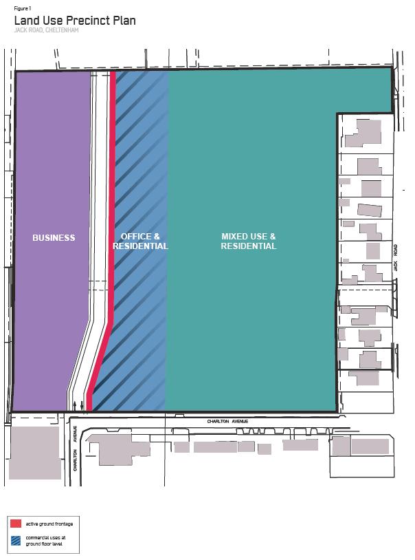
The use of the site for residential, home office, small scale retailing, office and other small scale commercial uses that will contribute to the creation of sustainable, active, mixed use environments,generallyinlinewiththeLandUsePrecinctPlanshownatMap1.
A range of small scale retail uses that cater to the needs of new residents on the site and whichsupportthesurroundingbusinessprecinct
The arrangement of uses across the site should allow for some areas of interaction between usesandsomeareasofseparation
Active frontages at ground level for office, home office or small scale retailing uses along the new north-south road that will connect the southern end of Chandos Avenue to Charlton Avenue,generallyinlinewiththeLandUsePrecinctPlanshownatMap1.
Residential access along the new north-south road that will connect the southern end of ChandosAvenuetoCharltonAvenueshouldbediscouraged
Built Form and Public Realm
Thedevelopmentplanmustshowormakeprovisionfor:
Appropriate landscape buffers and/or transitional treatments along all boundaries to the precinct and where a change in land use occurs, to ensure the future residential amenity on thesiteisnotadverselyimpactedbytheongoingoperationofabuttingnon-residentialuses.
Conceptual building envelopes and the general layout and height of proposed buildings, showing the graduation of built form from one to two storeys at the residential interface with JackRoadrisingtoamaximumoffivestoreystowardsthecentralandwesternportionsofthe site
Detail on the proposed contemporary architectural expression including design philosophy, useofcontemporarymaterialsandfinishesandbuildingarticulation.
Acontributionof5percentpublicopenspace.
Design and interface treatments of public open space including the response to surrounding buildings
An explanation of how the development will improve the interface with adjoining areas with particularattentiongiventoJackRoadandCharltonAvenue
The proposed design concept for all streetscapes, public realm areas and landscape buffers / interfaces with abutting land uses The proposed treatments must be responsive to the location,natureandamenityofabuttinglanduses
Movement andAccess
Thedevelopmentplanmustshowormakeprovisionfor:
The provision of appropriate vehicle and pedestrian linkages that support the development’s integrationwiththesurroundingareaandlocalpublictransportnetworks.
Proposed road layout, including a new north-south road through the precinct, and the requirement that commercial and industrial traffic utilise this connection instead of Jack Road
The road layout will be designed in a manner that prevents vehicle movement between the newnorth-southroadandJackRoad.
Inadditiontothenewnorth-southroadthatwillconnectthesouthernendofChandosAvenue to CharltonAvenue, vehicular access to the site from CharltonAvenue is to be limited to no morethantwoaccesspoints
Theprovisionoffunctionalandsafebicycleandpedestrianlinkagesthroughtheprecinct
Theprovisionofconvenientlockablebicyclestoragefacilities
A traffic report must be prepared by a suitably qualified traffic engineer and include the following:
Proposedroadcross-sections
Trafficmovementstoandfromthesiteandtheimpactoftrafficonneighbouringstreets.
Bicycleandpedestrianlinksthroughtheprecinct.
Onstreetandoffstreetparkingprovision.
Hownewroadinfrastructurerequirementswillbedelivered Atrafficmanagementplanfortheproposeddevelopment
Environmentally Sustainable Development Guidelines
Toinclude:
An assessment of the development against the Sustainable Design Scorecard and/or SustainableTools for Environmental Performance (STEPS).The development should achieve compliance with the Sustainable Design Scorecard as expressed within the Sustainable Design Scorecard Tool or meet the STEPS targets (if for residential development) If a designer or developer wishes to go beyond compliance with the Sustainable Design Scorecard/STEPS, alternative industry methodologies, such as GreenStar for office buildings, wouldbeconsideredbyCouncilinlieuoftheSustainableDesignScorecard/STEPS.
How the orientation and layout of the development makes appropriate use of daylight and solarenergy.
Water sensitive urban design solutions for managing storm water discharge throughout the site including public areas and roads and consideration of the potential for diverting storm waterforreuseoff-site
Incorporation of rain water tanks into the design to capture and store rain water for use in privategardensandpublicopenspacewithinthedevelopment.
Provisionofenergyefficientpubliclighting.
Additional information required:
Alandscapeconceptmasterplan.
An infrastructure servicing report prepared by a qualified consultant addressing the future servicingandinfrastructurerequirementsofthedevelopment.
An acoustic assessment (prepared at the cost of the applicant/land owner) by a qualified acoustic engineer which provides a noise assessment of existing industrial / commercial uses immediately abutting the precinct and recommends appropriate noise attenuation measures foranyproposedresidentialuses
Detailsofanyproposedstagingofthedevelopment.
Detailsontheproposedfundingarrangementsforthenewnorth-southroad.
5.0 Decision guidelines
In assessing a development plan or amendment to a development plan the responsible authority shouldconsider:
Thepurposeofthezone
How the proposal contributes to the objectives of the Business Employment Area Policy (Clause2204)
Clause56oftheBaysidePlanningScheme.
Thefindingsofthesiteanalysis.
Interfaceswithadjacentuses.
The character and appearance of any proposed buildings or works and their impact on the characterandamenityofsurroundinguseanddevelopment
Theoperationalrequirementsofsurroundingindustrialandcommercialuses
Thelayoutofcarparkingandaccessways.
Anywrittencommentsreceivedinresponsetothedisplayofthedevelopmentplan.
Map 1 to Schedule 1 to Clause 43.04
45.03
01/07/2021 VC203
45.03-1
04/05/2022 VC210
ShownontheplanningschememapasEAO.
Purpose
ToimplementtheMunicipalPlanningStrategyandthePlanningPolicyFramework
To ensure that potentially contaminated land is suitable for a use which could be significantly adverselyaffectedbyanycontamination
Application
This provision applies to land in an EnvironmentalAudit Overlay and applies whether or not a permitisrequired.
Requirement
Before a sensitive use (residential use, child care centre, kindergarten, pre-school centre, primary school, even if ancillary to another use), children's playground or secondary school commences or before the construction or carrying out of buildings and works in associationwiththeseusescommences:
A preliminary risk screen assessment statement in accordance with the Environment Protection Act 2017 must be issued stating that an environmental audit is not required for the useortheproposeduse;or
An environmental audit statement under Part 83 of the Environment Protection Act 2017 mustbeissuedstatingthatthelandissuitablefortheuseorproposeduse;or
Acertificate of environmental audit must be issued for the land in accordance with Part IXD oftheEnvironmentProtectionAct1970;or
Astatement of environmental audit must be issued for the land in accordance with Part IXD of the Environment ProtectionAct 1970 stating that the environmental conditions of the land aresuitablefortheuseorproposeduse
Exemption from requirement
The requirement for a preliminary risk screen assessment statement, an environmental audit statement, a certificate of environmental audit or a statement of environmental audit in this provisiondoesnotapplytotheconstructionorcarryingoutofbuildingsandworksif:
The buildings and works are associated with an existing sensitive use, secondary school or children’splayground,includedinClause62.02-1or62.02-2,andthesoilisnotdisturbed;
The buildings and works are required by the Environment Protection Authority or an environmental auditor appointed under the Environment Protection Act 2017 to make the site suitableforuse;or
The buildings and works are reasonably required by environmental auditor appointed under the Environment Protection Act 2017 or the Environment Protection Act 1970 to undertake a preliminaryriskscreenassessmentorenvironmentalaudit.
31/07/2018
VC148
45.06-1
19/01/2006
VC37
45.06-2
19/01/2006
VC37
ShownontheplanningschememapasDCPOwithanumber
Purpose
ToimplementtheMunicipalPlanningStrategyandthePlanningPolicyFramework
To identify areas which require the preparation of a development contributions plan for the purpose of levying contributions for the provision of works, services and facilities before developmentcancommence.
Development contributions plan
A permit must not be granted to subdivide land, construct a building or construct or carry out worksuntiladevelopmentcontributionsplanhasbeenincorporatedintothisscheme.
This does not apply to the construction of a building, the construction or carrying out of works orasubdivisionspecificallyexcludedbyascheduletothisoverlay
Apermitgrantedmust:
Beconsistentwiththeprovisionsoftherelevantdevelopmentcontributionsplan.
Include any conditions required to give effect to any contributions or levies imposed, conditionsorrequirementssetoutintherelevantscheduletothisoverlay.
Preparation of a development contributions plan
The development contributions plan may consist of plans or other documents and may, with the agreementoftheplanningauthority,bepreparedandimplementedinstages
Thedevelopmentcontributionsplanmust:
Specifytheareatowhichtheplanapplies.
Set out the works, services and facilities to be funded through the plan, including the staging oftheprovisionofthoseworks,servicesandfacilities
Relatetheneedfortheworks,servicesorfacilitiestotheproposeddevelopmentoflandinthe area
Specifytheestimatedcostsofeachoftheworks,servicesandfacilities.
Specify the proportion of the total estimated costs of the works, services and facilities which is to be funded by a development infrastructure levy or community infrastructure levy or both
Specify the land in the area and the types of development in respect of which a levy is payable and the method for determining the levy payable in respect of any development of land
Providefortheproceduresforthecollectionofadevelopmentinfrastructurelevyinrespectto anydevelopmentforwhichapermitisnotrequired.
Thedevelopmentcontributionsplanmay:
Exempt certain land or certain types of development from payment of a development infrastructurelevyorcommunityinfrastructurelevyorboth.
Provide for different rates or amounts of levy to be payable in respect of different types of developmentoflandordifferentpartsofthearea
2.0
17/08/2017 C139
ShownontheplanningschememapasDCPO1
BAYSIDEDRAINAGEDEVELOPMENTCONTRIBUTIONSPLAN
Summaryofcosts
4.0
15/01/2024 VC249
Note: The levy payable by development on residential land is specified in dollars per dwelling (note: a ground floor dwelling equates to 2 upper floor dwellings) and for other development in dollars according to site area
The levy payable by commercial development is in dollars per 100 sq m of site area or additional gross building floor area, whichever is the lesser
The amounts in this schedule are in December 2014 dollars The responsible authority will adjust the levy annually commencing in 2017 by applying the Building Price Index, as published in the latest edition of Rawlinsons Australian Construction Handbook
Landordevelopmentexcludedfromdevelopmentcontributionsplan
Thefollowingdevelopmentisexemptfromthedevelopmentcontributionsplan:
Residential development that does not create any additional dwellings, including the development of landforasmallseconddwelling;
Commercialdevelopmentthatdoesnotcreateanyadditionalfloorspace;or Developmentonpublicland
Note: This schedule sets out a summary of the costs and contributions prescribed in the development contributions plan Refer to the incorporated development contributions plan for full details