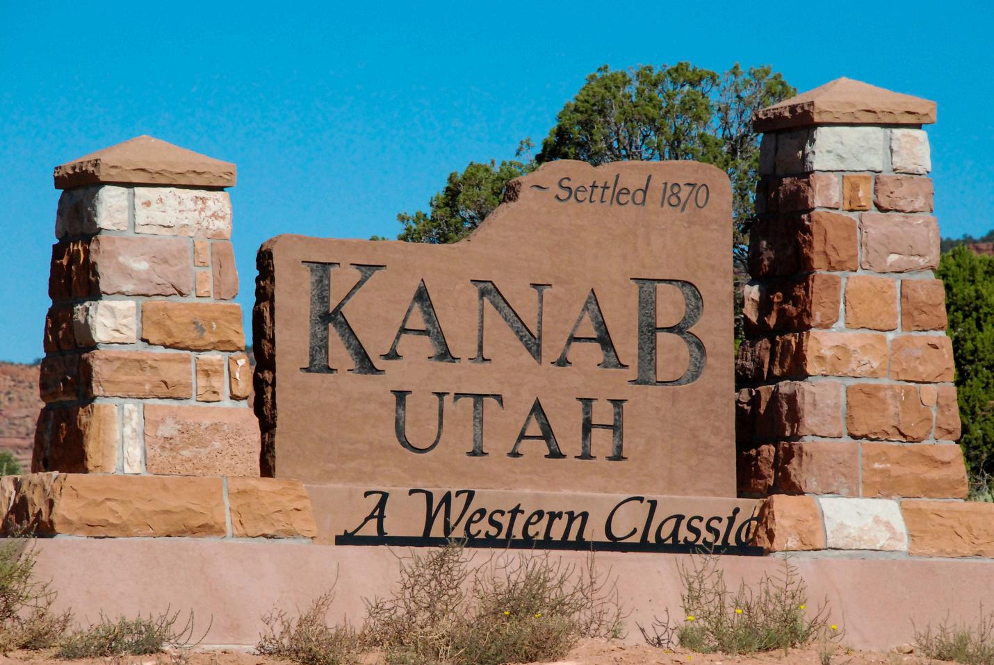

It feels miles from anywhere. The desert outpost sits on old Highway 89 the main north-south artery through the Intermountain West until the advent of the highway interstate system. Kanab may be off the interstate, but for adventurers to the desert southwest, it is not at all out of the way The iconic red rock approach gives way to green pastures then the lively main drag with the bookends of rocky outcropping standing watch over the town.
The little town of Kanab sits right in the southernmost reaches of Utah a stone’s throw from the region’s prime destinations, including multiple national parks, Lake Powell, and the Grand Canyon. This sparse sandstone landscape is rich in fascinating and adventurous things to do ranging from huge hikes (try the longest and deepest slot canyon on the planet, Buckskin Gulch) to colossal vistas (yep, the North Rim of the Grand Canyon is within day-tripping distance). It's also growing its reputation as an exquisite dining destination, which means foodies in your group won't go hungry.
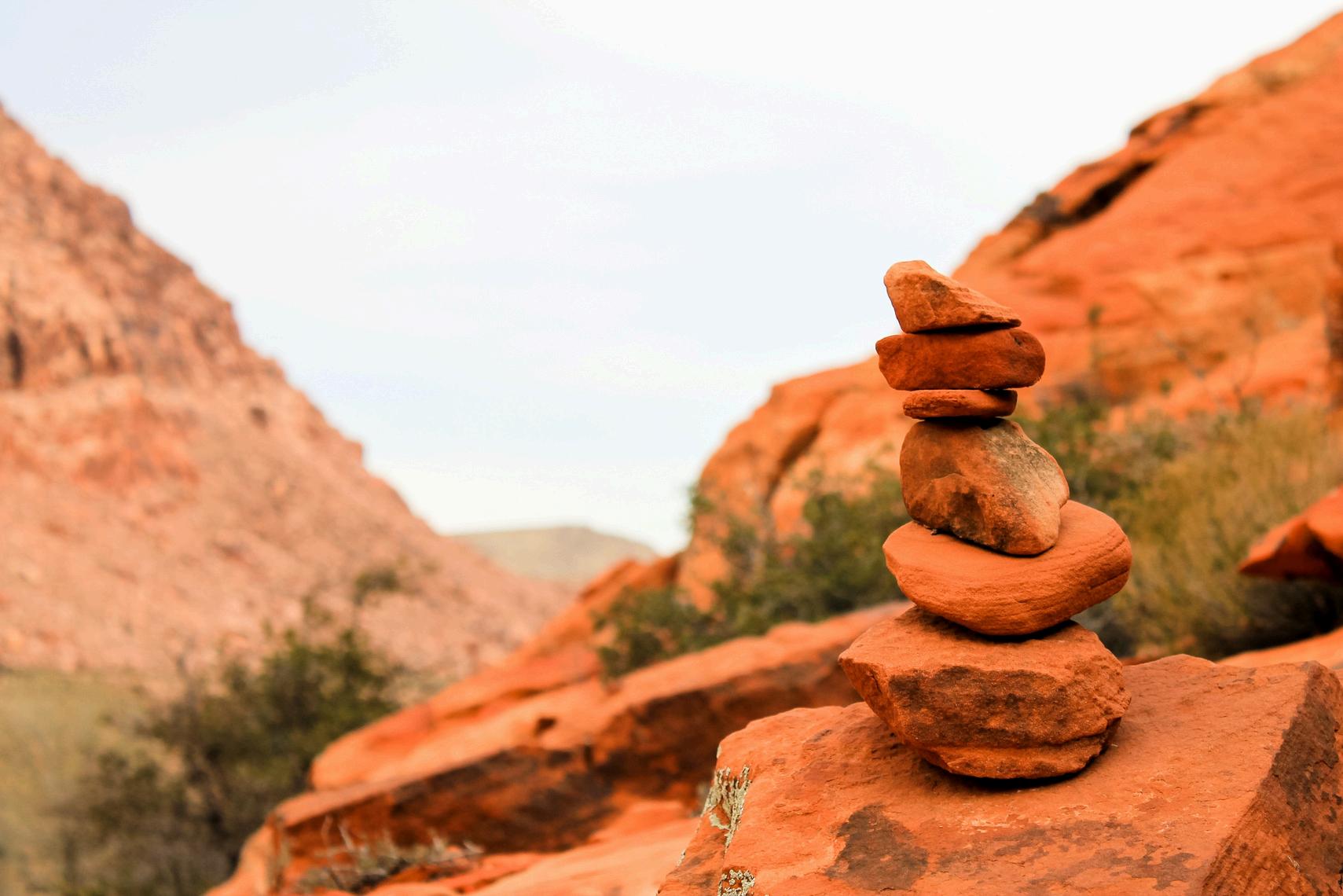
There are also plenty of mellow stop-offs for the traveler who’s in no hurry: short hikes, scenic roads, and even a quirky museum inside a cave. Here are a few of our favorite to-dos, in no particular order, spanning every level and ability. (Keep in mind, for most of these, you’ll want to get a detailed guidebook and map, and check the chance of rain/flooding before heading out.)
The North Rim offers a serene and enthralling Grand Canyon experience. It is more remote and less developed than the South Rim, and so it attracts far fewer tourists. Many people think its viewpoints are the most spectacular, since they are located at a higher elevation.
The North Rim fits nicely into a multi-park tour that also includes Zion, Bryce and Lake Powell. It is a relatively short drive between those scenic destinations Most tourists come into this area from Las Vegas. You can book multi-park tours from many vendors there. Because of the high elevation, visitors with respiratory or heart problems may experience difficulties at the North Rim If you have concerns, check with your doctor before visiting this area. The North Rim forms the edge of the Kaibab Plateau, with elevation ranging from 8,000-8,800 feet above sea level. Access is via Hwy 67, through a majestic conifer forest and past scenic Jacob Lake. The drive is beautiful, even before you reach the national park. Your first stop should be at the visitor center where you can orient yourself and enjoy one of the most spectacular views in the world. It's 40 miles from Jacob Lake to the North Rim visitor center.
The North Rim is officially open from mid-May through mid-October Services include a lodge, dining room/snack bar, campground, gas station and general store with basic supplies. Depending on weather conditions, it may be possible to drive to the North Rim during the spring or fall, but no visitor services will be available The lodge and campgrounds are usually full during the summer; reservations are needed and they should be booked as far in advance as possible.
North Rim mule trips are offered from mid May to mid October. One-hour rides along the rim and 1/2 day rim or inner canyon trips are usually available. Full-day trips into the canyon include lunch (The full-day trip does not reach the river ) Register in the lobby of the Grand Canyon Lodge at the Grand Canyon Trail Rides desk; open 7 a.m.-5 p.m. daily. For reservations, call Grand Canyon Trail Rides, (435) 6798665, or visit them at www.canyonrides.com/pkgra ndcanyon.html.
Coral Pink Sand Dunes is a very scenic area with dunes of warm, pink sand. The dunes have become a favorite place to ride off-highway vehicles. The park is located just southeast of Zion National Park, and offers views out over the Zion area.
Venture onto a shifting sea of red sand. Changed by winds, these mountains and hills of sand can move as much as 50 feet per year. With areas for off-highway vehicle enthusiasts and those with non-motorized pursuits, the dunes offer adventures for all.
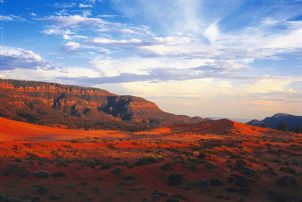
Coral Pink Sand Dunes State Park is open year-round, seven days a week, during daylight hours. The best times to go are spring, early summer and fall, as the temperatures are the most mild and the weather is usually cooperative. The park stretches 3,730 acres. It's the only major sand dune field on the Colorado Plateau and the only place in the world where you can find the Coral Pink tiger beetle The park has two concessionaires that generally operate from March-October. There is a daily use fee per vehicle, the annual Utah State Parks pass is also accepted. Tour buses are allowed. Pets must be on a six-foot leash at all times. Elevation is 6,000 feet.
When Zion National Park was established first as Mukuntuweap National Monument in 1909 and then officially as Zion National Park in 1919 there was just one problem: people had to get there. It was remote, and the trip to Zion required traveling along old, rugged wagon roads. By 1917, automobiles were able to roughly reach Zion Canyon, but there had to be a better way.
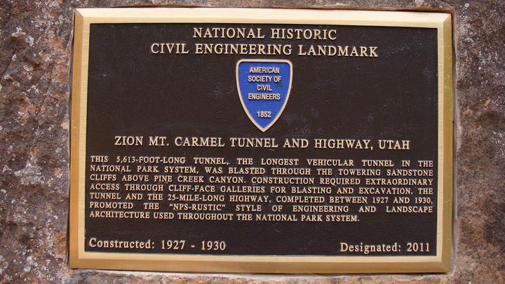
Construction of the Zion-Mount Carmel tunnel began in 1927, with the goal of providing access to the east side of Zion National Park, as well as create easier access to Bryce Canyon and the Grand Canyon. This revolutionary construction project to create the longest non-urban tunnel in the U.S. at the time was one of the great engineering feats of the day. The task was undertaken by the Nevada Construction Company, which used mining methods rather than traditional tunneling procedures, to create the Zion-Mt. Carmel tunnel. It took three years to complete the project at a cost of nearly $2 million (about $26 million today). The tunnel was dedicated on July 4, 1930.
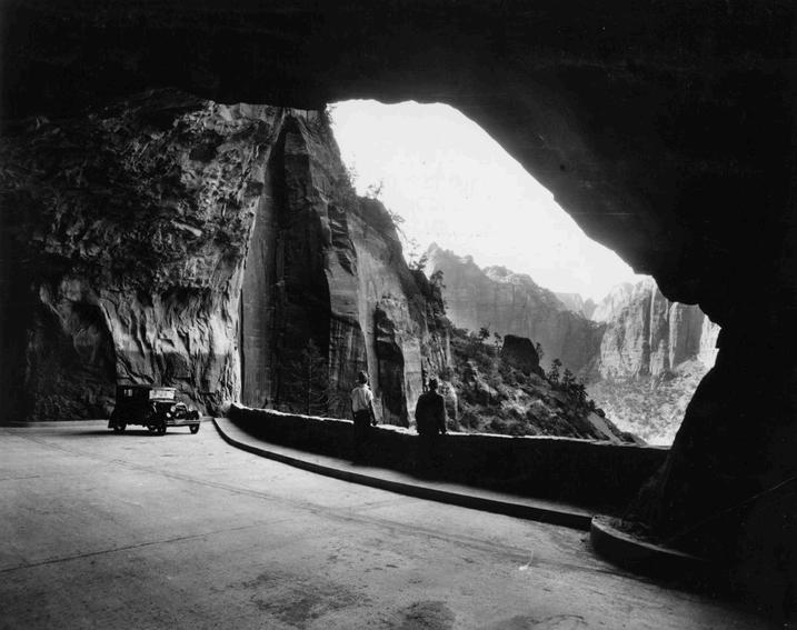
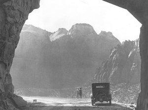
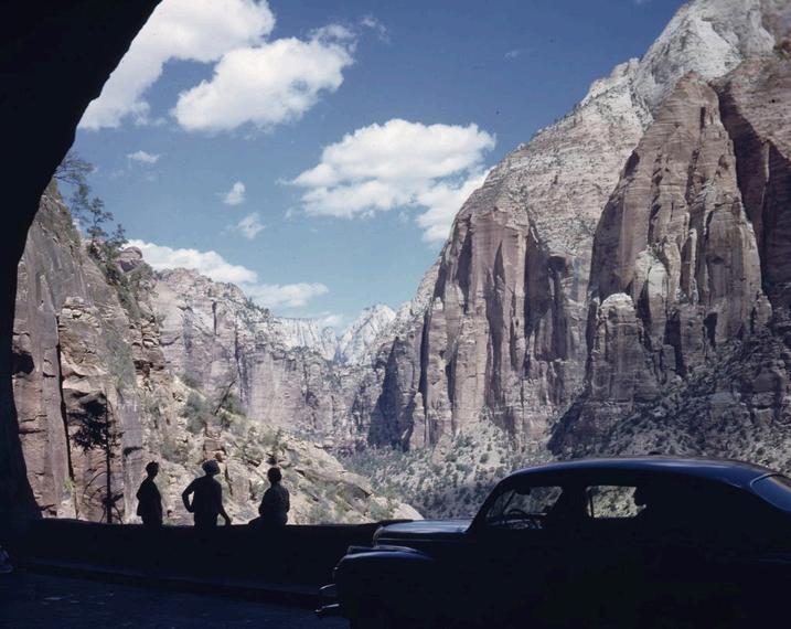
Pine Creek Canyon wall, and runs from the east entrance of Zion to the Mount Carmel Junction with U.S. 89. Six large windows cut into the sandstone cliffs offer glimpses of spectacular Zion scenery as visitors drive through the tunnel. This also provides light and ventilation inside the tunnel. Z I O N M T C A R M E L T U N N E L
olve and g y p p y was it a boon to the local economy by bringing in more tourists, but it also provided a vital thoroughfare between Washington and Kane counties and literally opened up a whole new world by offering access to east Zion with its different formations and wildlife than found in Zion Canyon via the park’s south entrance.
“The Zion-Mt. Carmel Tunnel has to be one of the great examples of cooperation in the creation of Utah’s tourism infrastructure,” said Zion National Park Forever Project Executive Director Lyman Hafen, also an aficionado of local history, in an email to St. George News. “Obviously, there was a real ‘can-do’ spirit that pervaded not only Utah, but the whole country in the mid 1920s, and most folks in southern Utah were supportive of building roads and connecting the relatively new national parks.”
In fact, the road and tunnel project were not approved until it was certain Bryce Canyon would be designated a national park.
Z I O N M T C A R M E L T U N N E L
SURVEYING THE TUNNEL
In the early 20th century, some engineers tried to figure out a way to build a road from Zion that would provide access east to Kanab and what would become U.S. Highway 89 and said it was impossible. Others came and said it might be possible, but it would be extremely expensive. It’s just a good thing that the surveyors were introduced to local stockman John Winder.
State and federal road commissioners came and investigated up and down the canyon looking for a way to build a road out the east side, Hafen said. Luckily for them, Winder, who had spent his life exploring the East Rim, had figured out the best way to trail livestock up to the summer pastures on the plateau.
“The engineers and commissioners could not come up with a suitable site or plan for a road until Winder took them into Pine Creek Canyon and told them that would be their best bet,” Hafen said. “If those outside professionals hadn’t sought out the kind of local knowledge John Winder could give them, we might not have the tunnel today.”
“The tunnel involved some new problems in engineering – problems that no engineer had ever tackled before,” The Salt Lake Tribune reported the day of the tunnel and road’s dedication. “The first of these was that the tunnel could not be surveyed by any of the usual methods. No human being had ever been at either of the points where the two portals of the tunnel now open to daylight.”
Z I O N M T C A R M E L T U N N E L
SURVEYING THE TUNNEL
Utah Governor George Dern was very complimentary of the surveyors at the dedication ceremony of the tunnel and road. They deserved every superlative he threw at them.
Dern said the early engineers visualized a road where it seem almost unbelievable that a road could be built.
“It was necessary to scale vertical cliffs by means of ropes and ladders in order to scout the territory and find an available alignment,” he said at the road and tunnel’s dedicatory program.
The surveying took place over a four year period and involved many “tedious and dangerous hours,” said Finch. “The engineers climbed and descended impossible cliffs and by means of ropes, waded in water to their waists for hours at a time and endured temperatures ranging from zero to 120 degrees.”
Despite these conditions, the surveyors were accurate in their measurements and “conquered the difficulties of surveying the tunnel with such success that at no place were the workmen more than three inches out of line with one another in making their bores meet,” The Salt Lake Tribune reported at the time of dedication.
“The fact that workers began at each end of the mile-long project, drilling and blasting through solid rock and darkness and somehow ended up less than a foot off from meeting perfectly in the middle, is an amazing example of cooperation,” Hafen noted.
Z I O N M T C A R M E L T U N N E L
TUNNEL AND HIGHWAY CONSTRUCTION
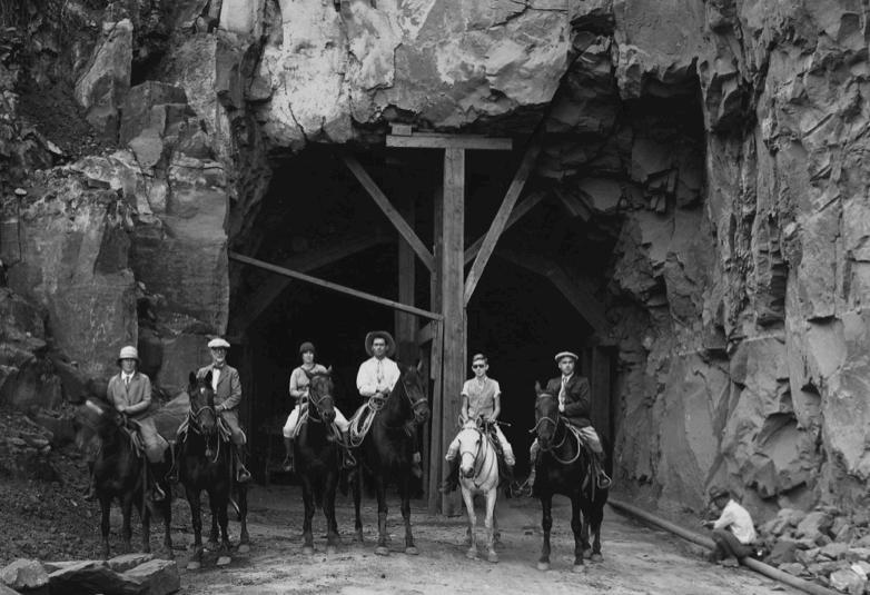
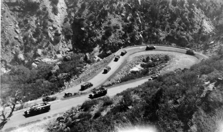
Construction of the tunnel and highway commenced in September 1927. The Nevada Construction Company of Fallon, Nevada, earned the contract to build the tunnel and set up a contractor’s camp in Pine Creek Canyon that included a cable tramway traveling 1,200 feet across and 400 feet up from the canyon floor to the camp, which was then inaccessible by vehicle.
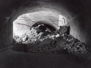
A lot of blasting took place to build the road and tunnel – blasting away sandstone that stood in the way with dynamite on both the east and west sides of the tunnel. For instance, large boulders in the path of where the roadway would be had to be blasted into smaller rocks to prevent catastrophic accidents.
Dynamite wasn’t without perils. One blast sent a 10-pound piece of sandstone inside the camp’s mess hall, prompting camp residents to run outside and stand close to the canyon walls when any dynamite went off so they could avoid becoming a casualty.
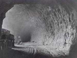
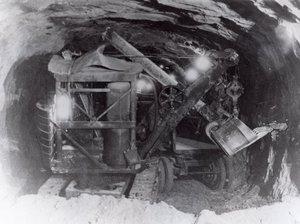
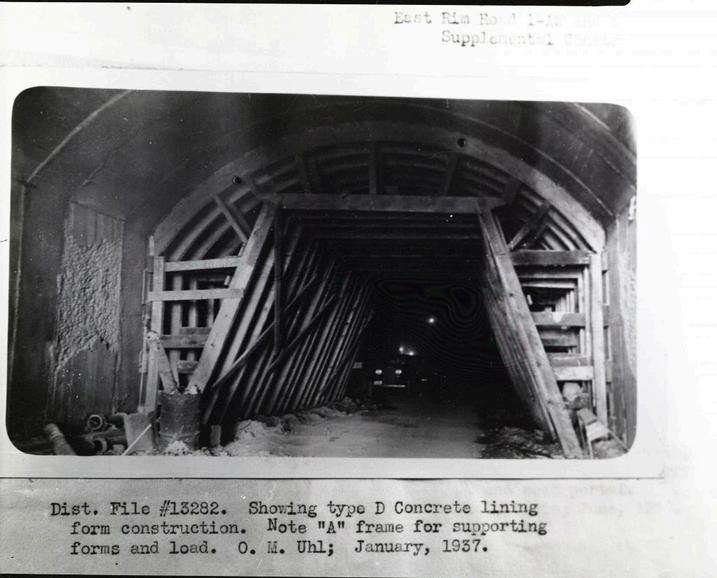
The first step in building the tunnel was blasting six galleries approximately 20 feet into the sandstone. From those galleries, workers drilled a pilot tunnel through the sandstone monolith and enlarged it using 146 tons of dynamite, removing the debris with an Erie Air Shovel, powered by compressed air to cut down on pollution and smoke.
Z I O N M T C A R M E L T U N N E L
TUNNEL AND HIGHWAY CONSTRUCTION
Construction of the tunnel and highway commenced in September 1927. The Nevada Construction Company of Fallon, Nevada, earned the contract to build the tunnel and set up a contractor’s camp in Pine Creek Canyon that included a cable tramway traveling 1,200 feet across and 400 feet up from the canyon floor to the camp, which was then inaccessible by vehicle.
A lot of blasting took place to build the road and tunnel – blasting away sandstone that stood in the way with dynamite on both the east and west sides of the tunnel. For instance, large boulders in the path of where the roadway would be had to be blasted into smaller rocks to prevent catastrophic accidents.
Dynamite wasn’t without perils. One blast sent a 10-pound piece of sandstone inside the camp’s mess hall, prompting camp residents to run outside and stand close to the canyon walls when any dynamite went off so they could avoid becoming a casualty.
The first step in building the tunnel was blasting six galleries approximately 20 feet into the sandstone. From those galleries, workers drilled a pilot tunnel through the sandstone monolith and enlarged it using 146 tons of dynamite, removing the debris with an Erie Air Shovel, powered by compressed air to cut down on pollution and smoke.
Workers dumped the waste and debris from the formation of the tunnel through those galleries via narrow-gauge railcars. Over the years, revegetation and erosion have erased any trace of this dumping. Z I O N M T C A R M E L T U N N E L
TUNNEL AND HIGHWAY CONSTRUCTION
It seems counterintuitive, but even though they took no thought to dumping debris out of the galleries, construction crews were careful not to disturb trees within the blasting area. By the same token, plans for the switchbacks of the road leading up to the tunnel were altered slightly to avoid disturbing a striking rock outcropping known locally as “Sandwich Rocks.”
The 1.1-mile tunnel was ultimately cut to a width of 22 feet and height of 16 feet. One report noted that 10 holes were made in the mountain that were connected to create the tunnel.
Just as the National Park Service rustic architecture like Zion Lodge being built at the time, affectionately known as “Parkitecture,” the bridges and masonry walls of the highway were planned to harmonize with the surrounding landscape and often used the same sandstone as the monoliths themselves to enhance the natural beauty.
Not coincidentally, the Zion-Mt. Carmel road follows the identical route surveyed by the pioneers 35 years before as a road connecting Kane and Washington counties.
Only two crew members were killed during construction: crew boss Johnny Morrison after inhaling too much dust and dynamite fumes and Mac McClain after being pinned against a power shovel after a rock slide. Z I O N M T C A R M E L T U N N E L
TUNNEL AND HIGHWAY CONSTRUCTION
The tunnel’s original six galleries gave visitors the opportunity to stop and see the surrounding scenery, which includes East Temple and the Great Arch, in a different perspective. At the time, traffic was much lighter and cars were smaller, so it did not cause any problems for people to stop and gawk.
The first gallery closed because water seepage through the opening iced the highway in winter. A rockslide on April 28, 1958, sealed another gallery, prompting the whole tunnel to be reinforced with extra steel and concrete. Over the years, two other galleries closed, leaving only two open today for ventilation. Stopping in the tunnel is now prohibited because of increased traffic. Z I O N M T C A R M E L T U N N E L
Many who attended local high schools tell stories of running through the tunnel in darkness, running their hands along the sides to keep their bearings in the dark, often as a result of a dare. Some even admit to running through it naked as part of a forbidden rite of passage. But that was during a different time, when Zion’s visitation was much lower and the tunnel was more inviting and friendly.
One 89-year-old woman who grew up in Springdale told of a time when she and her friends would actually have parties in the tunnel. Dolores Spendlove, whose grandfather was John Winder, who in addition to helping out the surveyors, worked on the tunnel later. She said she fondly remembers eating watermelon and chicken while listening to music on a phonograph in the tunnel. She and her friends even roller-skated in the tunnel and she got engaged there, too.
Spendlove and her friends would slip into the windows or hide in the cracks of the walls when cars would pass, she said. One time, she climbed out one of the windows and scratched her name in a rock. She said she got a letter from the park asking her to scratch out her name.
There is practically no way such shenanigans could take place in the tunnel today with high visitation and strict traffic control in the tunnel. In fact, a bicyclist was severely injured trying to ride through the tunnel three years ago. Z I O N M T C A R M E L T U N N E L