Jackson Hole


It is getting harder to get around Jackson Hole every year, for people and wildlife. Traffic congestion on Wyoming State Route 22 (WY-22) has increased significantly in recent years, affecting the lives of many workers forced into long commutes by high local housing costs and threatening wild animals with whom we share the valley. The lack of alternatives, particularly for longer trips, keeps people driving and results in more congestion.
Jackson Hole' transportation challenges result from growth pressures from many sources:
• Population growth
• Growth in tourism and visitation—still our largest 'industry'— resulting in significant seasonal traffic volume increases
• Growth of "exurbia"—workers forced to move out of Jackson proper immediate surrounding and move to outlying areas— cause rapidly increasing home pricing in Teton County
These pressures impact every aspect of life in Jackson, including wildlife, wild character and natural surroundings that the Jackson Hole Conservation Alliance (the Alliance) exists to protect.
The Alliance commissioned a comprehensive assessment of transportation challenges and potential solutions for our valley by nationally acclaimed traffic engineers, Nelson\Nygaard, specialists in sustainable, community-based transportation
solutions. This exhaustive process utilized technical analysis and stakeholder conversations (including with members of the Teton Transportation Coalition) to develop transportation solutions that are both ecologically responsible and sufficiently effective to meet the needs of our community.
The purpose of this report is to provide community members and elected officials with a discussion of options and recommendations that will both mitigate our traffic problems and minimize the negative impacts on wildlife and rural character of Jackson Hole's western valley. The options explored in this report include both increases in paved surface and lanes of traffic, as well as variations that rely primarily on other methods of mitigating the increased traffic volumes.
We believe a phased approach is the best approach. First, we should exercise those mitigation strategies, as detailed in the report, that will improve traffic outcomes without additional lanes. Then, let's see what additional lanes are necessary, if any.
Our six-point proposal is outlined in detail in the following pages and we hope it will provoke a robust community discussion. An informed, united community is our best chance to obtain an optimal outcome, working with WYDOT. We encourage your active participation in the discussion.
Jackson Hole Transportation Study1 2 3
With these guiding principles in mind, the Alliance is proposing a six-point solution. Our proposal is based on the well-developed science of traffic management and reflects Jackson Hole’s aspiration to be an example of best practices for the next generation. It also takes into account many conversations we have had over the last year with community members, stakeholders, and elected leaders.
Transit utilization and infrastructure need to be a community priority. Southern Teton Area Rapid Transit (START) must increase bus service frequency (particularly on commuter routes) and implement a fare-free program. We will advocate for new and expanded means to pay for transit service expansion, and transit priority must be included in any future roadway and intersection design. This is about moving people not vehicles.
The Town of Jackson needs to implement managed parking in the downtown area. Mobility pricing is among the most effective tools for managing demand and reducing unnecessary auto trips. Managed well, paid parking can also be a tool to regulate availability, ensuring that space is available for visitors and customers.
4 5 6
Teton County’s excellent pathway system has us well positioned to take advantage of the increasing availability and affordability of e-bikes. We will advocate for increased neighborhood connectivity and safe routes to school to incentivize a shift in travel mode from automobile to bicycle. Summer congestion could be significantly reduced if more trips were made on our pathways.
Hold off on the Tribal Trails connector until we have a comprehensive plan for the WY-22 corridor. The traffic science shows that Tribal Trails will likely make the congestion problems on WY-22 even worse. We need a holistic approach to the design of our community’s primary transportation corridor.
Jackson Hole Transportation StudyWYDOT is scheduled to start a planning and environmental process for WY-22 in the next few years. To demonstrate the community’s collective interest and ability to shift toward sustainable travel, it is imperative to act now. Implementing “demand management” measures that discourage parking in town and encourage carpooling and bus riding will reduce driving demand and move Jackson Hole toward its collective values. Any widening of WY-22 is years away, but these tried and true demand management tools are available today.
Transportation demand comes from a series of small individual choices and actions made every day. The demand management playbook put forth in this plan includes options to provide travelers new and better choices, leading to a healthier, safer, more sustainable, and more wildlife friendly Jackson Hole.

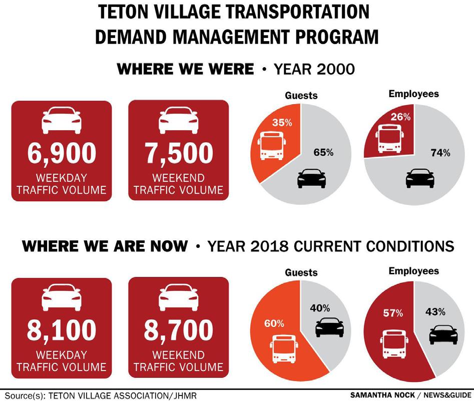
It’s hard to get around Jackson Hole, for people and wildlife, no matter how you’re trying to get where you need to go. Neighborhoods lack sidewalks and streets aren’t safe for kids to ride bikes to school. Unless you’re going to and from Teton Village during the winter, the START bus just doesn’t work for most of us. There’s rarely another route that will reach your destination. These obstacles force most of us into cars for a majority of our local travel, generating 60% of the area’s pollution related to climate change, a concern commonly identified by community members.
On average, 114 mule deer, 35 elk, and 15 moose are struck and killed by motorists every year on Teton County roads. The summer tourist season floods our roads with traffic. Because of this seasonal congestion, and because many mistakenly believe that wider roads will alleviate congestion (despite decades of data

proving wider roads only encourage people to drive more and do not reduce congestion), WYDOT is developing plans to dramatically expand the highways that bisect the community, which would harm community character and make it even harder to get around.

Teton County adopted an Integrated Transportation Plan (ITP) in 2015. Founded on the Teton County Comprehensive Plan values of Ecosystem Stewardship, Managed Growth, and Community Character, the ITP was intended as a blueprint that would “make travel by walk, bike, carpool, or transit more convenient than travel by single-occupant vehicle". A 2020 technical update to the plan tracked progress between study years of 2013 (used in the 2015 plan) and 2018. During that time that total miles driven per capita rose 50%. Anecdotally, traffic continued to increase in 2020 and 2021 as many people relocated to the area during the COVID pandemic and visitation surged.
It’s clear that a laudable vision and goals are not enough to uphold the community's values. Business as usual threatens to sacrifice the community's values and overturn the community's aspirations. Action is needed.

Reducing demand for driving can protect the most valued places.
Support a ordable housing and development patterns that keep people close to jobs and promote walkable neighborhoods.
Sustainable transportation reduces impacts to streams and wetlands.
In 2021, Nelson\Nygaard conducted an analysis of Jackson Hole to develop a clear vision for the future of the valley’s transportation system, starting with the WY-22/390 corridor.
This analysis, with guidance from stakeholders across the valley, developed transportation solutions that are ecologically responsible and sufficiently effective to meet mobility needs. The goal is to prioritize community character and
More people riding transit, walking and cycling means more wild lands and recreation space are preserved.
Speed management and less vehicles can save wildlife on roads and highways.
natural ecosystems, while providing safe and effective means of moving people around the valley. This study attempts to put forward a practical, but aggressive, approach for managing demand for driving in Jackson Hole and advocates for an aggressive implementation of demand management tools, smart and sustainable growth, and a holistic vision for the WY-22/390 corridor.
HUMAN Safety
Walkability
Access to housing Scenic value
ECOLOGICAL
Wildlife habitat
Wildlife safety
Wild lands
Waters
Wetlands
ECOLOGICAL ECONOMIC HUMAN
SOLUTIONS
A solution that is ecologically responsible and sufficiently effective to meet mobility needs is ncessary to garner public support. Finding balance will require weighing which outcomes are most critical and using community values to guide tradeoff decisions.

ECONOMIC Freight/Goods
Commuting Tourism Government
Local business
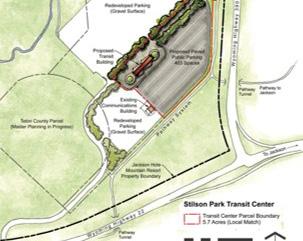
Teton County is building on important progress, including the START Bus transit program, the Teton Village Association transportation demand management program, a nation-leading pathways program pushed by strong advocacy, and a successful local effort to land a federal Better Utilizing Investments to Leverage Development (BUILD) grant for the Stilson Transit Center. This grant will expand bus and pathway infrastructure. These are examples of local initiatives working to move the dial on sustainable transportation.
Southern Teton Area Rapid Transit (START) is the transit provider to Jackson and Teton County, WY. START operates services within Jackson, throughout Teton County, and connecting commuters from Star Valley and Teton Valley in Idaho. START is expanding services under the guidance of its 2020-2025 START Routing Plan. This includes the addition of START On-Demand, a flexible, small vehicle service that provides free, on-demand transportation using smaller vehicles between the western boundary of Karns Meadow and the Town's eastern limits.

The Teton Village Association (TVA) was created in part to mitigate traffic congestion on Highway 390. A robust program that includes paid parking during ski season, parking management in the commercial core of Teton Village, transit incentive programs, hotel partnerships, free parking and shuttle service from Stilson, and subsidies to increase bus frequency have been essential to reducing winter traffic in the WY390 corridor. TVA's program is a shining local example of successful demand management. These same strategies can work for the WY-22 corridor.
 START has seen the greatest success serving Teton Village during peak winter months. This success demonstrates the power of frequent transit service combined with demand management measures.
The Town of Jackson, Teton County and strong local advocacy groups such as Friends of Pathways have built and continue to grow a worldclass network of off-street pathways for cycling, walking, rolling, and Nordic skiing. Pathways connect neighborhoods and provide safe, convenient access to schools, employment centers, and other destinations that are integrated with the roadway and transit systems. Pathways are critical to help meet local goals of 10% of all trips by walking and cycling.


The Teton Mobility Corridor Improvements (TMCI) project is the result of stakeholder and local government efforts to tap competitive federal funds (BUILD grant program) to improve our local transit systems. The grant will provide funding for over a dozen projects that contribute to better public transit, pathways connection, and safety in the WY-22 and ID33 corridor.
 Pathways in the WY-22 and WY-390 corridor offer safe and scenic travel for cyclists traveling between Jackson and Wilson or the West Bank/Teton Village.
Planned improvements to Stilson Transit Center are a centerpiece among more than a dozen other transit and pathway improvements.
A proliferation of electric bikes makes travel times on the pathways competitive with peak period driving.
TMCI projects were developed with guidance from established regional values and plans. Each project will help move the region toward sustainable transportation goals.
Pathways in the WY-22 and WY-390 corridor offer safe and scenic travel for cyclists traveling between Jackson and Wilson or the West Bank/Teton Village.
Planned improvements to Stilson Transit Center are a centerpiece among more than a dozen other transit and pathway improvements.
A proliferation of electric bikes makes travel times on the pathways competitive with peak period driving.
TMCI projects were developed with guidance from established regional values and plans. Each project will help move the region toward sustainable transportation goals.
The United States has a history of supply-side driven approaches to managing people’s transportation needs—roads are constructed, cities and regions grow, those roads fill with vehicles, and more capacity is added. This cycle is driven by government process and lucrative auto manufacturing, fossil fuel, and road building industries. However, its perils are clear—vehicles are among the largest contributors to climate change, road collisions are among the leading causes of death for humans and wildlife, and pavement predominates in the American landscape.
Decades of unchecked road building are fueled by profit and ease—ample road capacity and a vehicle in every driveway is a promise of “freedom.” The tragedy is that as this “simple” story is repeated over and over, we increasingly lose opportunity to build communities that properly balance human-oriented needs with ecosystem-friendly, and sustainable values. To reverse these trends, we need transportation systems that focus not on a generic “supply” target but on the specific demands of key travel markets.
While there are many reasons for travel, three key markets predominate in Teton County’s summer peak season:
LOCAL TRAVELERS
• Housing affordability crisis forces local workers to live outside Teton County
• Service and lower wage jobs require employees to be on site
• More people hold multiple jobs & work off-peak hours
• National Park and recreation visits at all time high
• Summer visitors pass through and/or visit multiple, distant attractions
• Lacking information, service, and infrastructure for summer visitors who don’t want to drive
• Low density development patterns increase price of frequent transit to everyone
• Limited disincentive to drive even for short trips
• Pandemic increased remote work from Jackson Hole
VEHICLE MILES TRAVELED PER JOB ACCESSED
SUMMER VISITORS RELIANT ON CAR TRAVEL
NUMBER OF LOCAL TRIPS BEING TAKEN BY CAR
• Affordable housing is in Idaho, creating longer commutes and limiting travel options
• Many service sector jobs
• Retail and service shifts span long hours
• People working trade and service jobs often travel with equipment and to job sites
• Other activities before or after work require flexibility
• Summer visitors travel to dispersed sites including National Parks
• Many travelers are driving through
• Options other than renting a car are not easy to identify before arrival
• Transit service levels are lower in winter and there is no service to key destinations
• Limited options to travel between lodging and the Airport
• More frequent transit
• More transit and vanpool service at off-peak times
• Commuter options
• Share ride opportunities at mobility hubs
• E-bike promotions that take advantage of pathway investments
• Enhanced pre-arrival travel options marketing/information
• Lodging provide cycling and transit encouragement programs
• Enhanced transit service
• Airport Shuttles
• Long-term parking solutions
• Build transit costs into lodging fees
• Lack of congestion at most times makes driving the fastest, most convenient option
• Dispersed housing is hard to serve with frequent transit
• Seasonal residents don’t have stable travel patterns (as a daily commuter would)
• During the Pandemic, more second homeowners make Jackson Hole a permanent home
• Walking, biking, and transit are more viable options for people living in Town
• Parking policy and management that realizes the full cost of driving and parking
If the community offers the same travel choices, will people change their travel behavior? Simply put, no. A status quo transportation system will lead to status quo behavior, exemplified by Teton County’s challenge in reducing per capita vehicle miles traveled since 2015, when the ITP targeted a reduction. To move the dial, it is critical to consider how and when people make choices that influence travel. Our travel behaviors are the results of decisions big and small:
MICRO
HOW WILL I MAKE MY NEXT TRIP?
What’s the quickest way to get there?
What trip best balances my budget and time available?
What mode of travel is safe, comfortable, and fulfilling?
MACRO
WHERE DO I LIVE, WORK, AND TRAVEL?
What housing can I afford?
Where will I choose to work?
How long, challenging is the commute?
What other places do I go regularly?
Teton County's affordable housing challenges make acute the tension between time and cost. Every year more people choose, or are forced, to travel farther to access affordable housing. Ultimately, people, who are displaced to a distance where travel becomes substantially burdensome, will seek opportunity to work closer to home. The choices people make about how and when they travel differ. The following graphic demonstrates how factors influencing trip decisions vary for different Teton County system users.
A sustainable mobility system stands on three legs. Simultaneous investment in each is the fastest and most effective path to healthy and balanced community mobility.
Teton County’s ITP is constructed on principles and measured by targets that are only realistic when fewer people choose to drive. Reducing per capital vehicle miles travelled (VMT) and driving mode share by sustainable modes—walking, biking, and transit— requires land uses that make those travel modes highly convenient, travel options that are competitive with hopping in the car, and policies that recognize the high costs of driving.
Affordable housing near jobs means people have options for travel.
Services, programs, and safe facilities allow people to bike, walk, take transit, share rides, and telecommute.
Incentives, pricing, and education encourage people to make choices other than driving alone.
Ask anyone in Jackson what the pain point in the transportation system is and you’re likely to get the same answer – Highway 22!
Commonly called “Induced Demand” and well proven in research and experience, adding travel lanes to congested highways simply allows more vehicle trips, causing the roadway to become congested again in relatively short order. The indicators for congestion to “fill back in” exist in Jackson – deferred trips, travel outside peak times, increased rates of cycling, etc.
Decreased Use of Transit, Walking, Bicycling
Encouragement to Drive
Induced demand or the cycle of “provide and predict” is a threat to Teton County and a reality to be addressed head on as stakeholders plan for the future of Highway 22 and Highway 390.
As with any limited resource, effective management of supply and demand is the key to community health. The Teton County Comprehensive Plan and the ITP state clearly that vehicle demand should be managed downward, and necessary supply offered through sustainable modes—a virtuous cycle. This virtuous cycle requires that local stakeholders:
• Recognize mobility demand exists and will continue to grow.
• Prioritize reliable non-auto travel options—walking, cycling, transit and vanpooling
• Develop and support—with funding and staff—programs, incentives, and disincentives that encourage and educate people on the use of sustainable travel options.
• Build political support for constituents for the new way of travel, using incremental achievements to create meaningful change
Political support grows, more funding
Reliable options made attractive: cycling, transit and HOV
New trips are added at lower rate of driving
Destination of trips in the WY-22 corridor between WY-390 and the "Y”.
Expansion of WY-22 through Teton Pass would have massive environmental impacts and could cost billions of dollars. Managing demand for driving between Idaho and Jackson is the best way to solve congestion problems.
Habitat, protected wild lands, scenic rivers flank WY-22.
Making better use of the current highway right-of-way is essential to protecting the wildlife and wild lands that Teton County residents value most.
20-25%
10-15%
WYDOT and Teton County have approved the Wilson Multimodal Transportation Plan, which calls for an urban street design in downtown Wilson that includes one-lane per direction and a center turn lane.
Between the 390 Interchange and the “Y” WY-22 carries 10-15% of all Teton County trips in the peak period. How it functions a ects traveler experience throughout Teton County.
Transportation efficient communities provide for housing near jobs and transportation options. Dense development, excellent walking and biking facilities, and a mix of housing types (including workforce housing) and commercial uses offer residents and visitors choice in how and where they travel.
The most critical ingredient for a transportation efficient community is responsible growth management.
• Provide a base for transit-oriented development.
• Promote walking, biking, and use of transit within neighborhoods.
• Reduce travel distances, enable “linked trips” where one trip provides for many activities, and allow drivers to park once and then get around easily on foot (as is the case currently in Teton Village).
• Provide the three Ds—population density, land use diversity, and pedestrian friendly design.
1 3
Reduces the costs of public services such as water, sewer, road infrastructure, police, fire, and emergency services.
PUBLIC SERVICE SPENDING
Improves ambient air quality because vehicle-miles travelled generally decrease.
AIR QUALITY
2 4
Supports mass transit and a wider array of non-motorized transportation options.
TRANSPORTATION OPTIONS
X
Helps decrease fossil fuel consumption.
FOSSIL FUEL CONSUMPTION
Increases economic productivity by creating an employment density that attracts additional investment.
ECONOMIC ACTIVITY
ECONOMIC ACTIVITY 5 7
Improves productivity by providing businesses with easier access to labor, suppliers, and supporting businesses.
LABOR COMPETITION
6 8
Provides low-wage workers better access to affordable housing near jobs and transportation options.
IMPROVES PRODUCTIVITY
AFFORDABLE HOUSING
Helps businesses compete for labor because many professionals and recent college graduates prefer to live near their work and walk to shops, restaurants, and entertainment.
If shifting more trips to walking, cycling, and transit is imperative, then an essential first step is making those modes convenient, safe, comfortable, and reliable for travel. Since it would be cost prohibitive and unreasonable to assume this could be possible for all trips at all times of day and during all seasons, focus should be on trips where alternative modes can be made competitive and appealing, particularly at times when roadway supply is most limited.
Agencies and the private sector in Jackson Hole are already making progress in this area. START is a model transit system for a small and rural service area with recent infrastructure investments that position it for growth, the regional pathway system is an envy of many big cities and more people are using it for daily transportation as e-bikes proliferate, and transportation demand management is being used effectively to move employees and skiers to Jackson Hole Mountain Resort.
20% OF AFTERNOON
PEAK WY-22
TRIPS BY BUS
10% OF AFTERNOON
PEAK WY-22
TRIPS BY BIKE
Getting 10% of afternoon peak travelers into buses on WY-22 between Jackson and the WY22/390 interchange would ease congestion, reduce future demands for highway expansion, increase passage safety in the corridor, and reduce wildlife and environmental impacts. But, getting to that level of transit travel will take continued and sustained investment, including:
• Full implementation of the START Bus Routing Plan (2020-2025)
• Expansion of commuter services to Star Valley and Teton Valley, ID from 8 (Routing Plan Target) to 12 round trips per day.
• Expansion of Highway 22/390 service from 32 (Routing Plan Target) to 48 round trips per day.
• Provision of transit priority or managed high-occupancy vehicle (HOV) lanes along Highway 22 to ensure operational reliability for START buses.
• Work with WYDOT to fund fare free commuter service pilot for Highway 22 during Snake River Bridge construction.
Increasing demand for long distance commuting should be addressed with more frequent commuter bus service. However, many workers in the service and medical industries face very early morning or late evening commutes, times when a full-size bus may not be cost effective. Reliable administration of a van fleet and ridematching services are critical to sustaining vanpool as a travel option. A Downtown Jackson Transportation Management Association (discussed more fully below) could provide those functions and manage recruitment and employer participation. START Bus could also act as the administering organization or the owner of the vehicle fleet, providing a local maintenance base and potential to use vans for midday services.
Vanpools would have a limited benefit for peak period congestion but are important in the suite of travel options that allow long distance commuters to leave their cars at home.
Teton County’s excellent pathway system has it primed to take advantage of the e-bike revolution. E-bikes already make up a sizeable percentage of bikes on County pathways during summer months. These safe facilities that shield riders from auto traffic make summer travel fun, fast, and reliable. During afternoon peak travel, one can ride from Jackson to Wilson on an e-bike in a comparable time to driving. With the rise of affordable electric bikes, they have become a regular summer sight on the pathway system. But what would a true revolution in e-biking mean for Jackson Hole travel?
• Over half of daily trips in Jackson Hole are under 8 miles, a comfortable riding distance on an e-bike.

• If 10% of trips in the Highway 22 corridor were made by bike during summer afternoons, congestion could be reduced.
Making reliable e-bikes readily available to everyone who is able to ride would be cost less than building one lane mile of new highway.
• A Town/County subsidy for e-bike purchase with an agreement to ride and log 10 trips per week during the summer.
• A hotel/lodging program that uses lodging tax to pay for a fleet of e-bikes stationed at hotels and rental properties. The program could include mobile maintenance and charging support.
• Safe bike storage including cardaccessed cages with charging infrastructure at key park-and-rides, including Stilson, points of connection with transit, and local destinations.
• Increased funding for pathways, including expansion and improved controls for intersections and crossings.
Few people will replace a Highway 22 auto trip with a walk, but the criticality of walkable neighborhoods cannot be overlooked. Capturing a 10% mode share on transit during peak periods will require that people feel safe and comfortable accessing the bus.
Increasing the percentage of new residential development that is constructed in compact, walkable neighborhoods where people can access goods and services by foot and bike is essential to reducing driving over the long-term
 Jackson Hole Transportation Study
Making access to electric bicycles ubiquitous could help reduce pressure on local roadways during summer months and take advantage of Teton County's excellent pathway system. In Park City, electric buses and electric bike share is a powerful combination to reduce transportation impacts.
Jackson Hole Transportation Study
Making access to electric bicycles ubiquitous could help reduce pressure on local roadways during summer months and take advantage of Teton County's excellent pathway system. In Park City, electric buses and electric bike share is a powerful combination to reduce transportation impacts.
B1 – START Bus should develop a long-range (2035 or 2040) service strategy that describes the types and levels of transit service investment needed to realize the level of corridor and system ridership needed to reduce auto reliance. Those include:
• Commuter services to Star Valley and Teton Valley add 8 daily round trips
• TVA – Stilson – Town service levels tripled during the summer compared to today.
• Grand Teton National Park shuttle or bus service implemented in concert with in-park circulation solutions
• New trail and recreation services implemented to provide car-free options for visitors.
Continued and strategic expansion of START Bus services is the foundation of a sustainable transportation system for Jackson Hole.

B2 – Provide either dedicated shoulder-lane capacity or a managed high-occupancy lane between Town and the WY-22/WY-390 interchange to make transit competitive.
B3 – Provide transit priority at the “Y” interchange (WY-22 and US-89/191). To avoid future grade separated solutions that would harm the small-town character of Jackson, focus on moving more people through this interchange.
C1 – Fund and promote an e-bike distribution program that provides an e-bike to Highway 22 commuters that agree to use a bus-to-bike mode 3 days per week or more. Use the Snake River Bridge mitigation as a trial period.
C2 – Work with Travel and Tourism and business leaders to develop and launch an E-bikes for Businesses and Lodging Program with intent to provide ubiquitous access to e-bikes for workers and visitors.
C4 – Increase funding for pathways program, particularly to enhance capacity at key junctions and points of constraint along Highway 22.
C5 – Fund and implement a card accessible bike cage program (phase 1 focus @ Teton Village, Stilson Park-and-Ride, Victor/Driggs Park-and-Rides, and the Airport)
Providing card-accessed, secured shelters with electric charging infrastructure would allow storage of e-bikes and incentivize people to make bus to bike trips. Photo shows Boulder County's Bike-N-Ride shelters.
 Jackson Hole Transportation Study

V1 – Develop vanpool services that serve very early morning and later evening trips to Star Valley and Teton Valley.
V2 – Consider park-and-ride based model for vanpooling similar to that developed in Missoula (Missoula-Ravalli TMA) to provide more flexible options for travelers.
V3 – Use TMA structure to develop vanpool market by working with employers and developing fare and incentive programs.
The Missoula Ravalli TMA has provided daily vanpool service with fixed stops and no-reservation pick-up for over 2 decades.W1 – Enhance access-to-transit and the transit waiting experience to optimize the investment in Start Bus service
W2 – Advocate for new multifamily housing development near highquality transit. The development of the Stilson site adjacent to the planned park-and-ride will be an important opportunity to build transitoriented development that can promote walking and transit use.
W3 – Leverage the newly formed TMA to promote walk, bike, and ride programs that encourage sustainable transportation.
 Jackson Hole Transportation Study
Transportation modeling conducted for this study has shown that both current summer season and future year (2035) travel demand in the Highway 22 corridor will support expanded capacity by traditional highway engineering principles. Modeling also shows that a four lane Highway 22 with no restrictions on lane usage will lead to significant increases in vehicle miles traveled within Teton County. Inducing more auto travel and reducing the efficacy of investments in pathways and START Bus goes against ITP goals and will move Teton County further from meeting critical climate and congestion targets.
It is time for Teton County to invest in transportation demand management programs (TDM) as WYDOT is leading a process to study Highway 22 alternatives. TDM is a proven suite of strategies, grounded in economics, that can be deployed to influence people’s travel choices.
A good TDM program doesn’t attempt to influence everyone’s travel behavior, but rather attempts to reduce unnecessary vehicle trips and shift the mode of trips that can be made regularly or most cost effectively on bike, bus, foot, or shared ride.
A successful TDM program requires participation from local government and the private business community. TDM efforts should focus on three key travel markets (see opposite page).
Most transportation problems share a common root: market distortions that result in excessive automobile use. From this perspective, solving transport problems requires planning reforms that increase transport options and market reforms that give consumers suitable incentives to choose the best option for each individual trip. The motto is, “increase transportation system diversity and efficiency.”
The transportation industry is perpetually looking forward to ask: what is the next BIG THING that will revolutionize mobility? Meanwhile, our U.S. states, counties, and cities struggle to maintain the infrastructure we have in place What is truly needed is an incremental approach that consists of management innovations that result in more efficient use of existing transportation systems. Both pricing—pricing parking is more efficient than roadway travel given enforcement challenges on roadways with limited access management—and incentives are essential to move the needle.
People traveling to jobs present the best opportunity to shift travel. Regular schedules are easier to build quality options for, such as fixed route bus service. People who make a trip daily also benefit from the opportunity to make better use of travel time (i.e., sleeping or working on a bus).
• Enhanced commuter bus service to Teton County, ID and Lincoln County, WY.
• Expanded park and ride system
• Dynamically scheduled commuter van service for offpeak trips
• Commute Trip Reduction Programing including requirements for large employers
• Downtown Jackson Transportation Demand Management Association
Summer visitors to Jackson often range widely to visit national parks, hike, and float the area’s wild river. This makes car travel attractive. Coordinated efforts to advertise car-free visitation options pre-arrival, provide options to key destinations, and coordinate with Grand Teton National Park are essential to reduce auto travel among this group.
• National Park bus from Stilson & Town
• Internal shuttle service at Grand Teton National Park
• Enhanced traveler information and travel options marketing
• Pre-arrival “visit without a car campaign”
• Expanded shared mobility options including car share
• Lodging and activity center based e-bike program
While summer visitors may push local roads to capacity (and over), residents make most trips on Teton County roadways. The diversity of trip types made by residents make targeted TDM programing a challenge. Essential ingredients to changing travel behavior include making transit and cycling ubiquitous and convenient while discouraging driving for short trips.
• Downtown Jackson parking management and pricing
• Right-size parking supply
• Reduce minimums requirements
• Encourage shared parking
• Expand local transit service
• Require developers to provide travel options over parking
• Fund a study/process to create a business and strategic plan for a Jackson TMA.
• Focus on uniting businesses around mitigation of other impacts of traffic congestion on employees.
• Consider organizing carpool/vanpool usage to mitigate congestion caused by Snake River Bridge renovation as a pilot project for the TMA.
• Consider TMA role in advocacy for parking management, promotion of travel options, education and promotion of START bus use, development of new commuter travel options, and working with the travel and tourism industry partners to reduce impacts of visitation.
• The Town of Jackson should implement Jackson Downtown Parking to price onstreet parking in the Short-Term Parking Zone as an easy way to reduce vehicular travel in this congested zone.
• Consider using the TMA to guide the use of parking revenue and programming to increase travel options and incentives (see Parking Benefit District recommendations in Town parking plan).
For every acre of land in Town, there are 54 parking stalls and 2 households.
Thoughtful parking management, including paid parking Downtown, will help better use the massive amount of parking already in place.
53.8
Visitors to Breckenridge are encouraged to visit without a car, even before they leave home.
• Pilot fare free transit in the Highway 22 corridor during the Snake River Bridge construction period. This would provide an opportunity to increase ridership, build long-term customers, and provide important traffic mitigation during the bridge construction period.
• Work with the newly formed TMA and businesses to consider how to make commuter services fare free permanently.
• Travel and Tourism should focus on mitigating impacts of high visitation to align with investment in programming that encourages car-free visits.
• Emulate information campaigns such as Breckenridge’s No Car? No Problem! Campaign and excellent online information

• Use the TMA structure to work with private lodging providers to increase access to e-bikes, encourage short-term car rentals, and promote transit.
• Expand START bus services to include shuttles for hiking, biking, and floating. Bend, OR has a popular “float shuttle".
• Consider START bus airport van service, including opportunities to expand use of on-demand fleet vehicles to serve the airport.
Immeasurable natural beauty, world-class recreation, and small-town charm are at the heart of what people love about Jackson Hole and are also at the center of the area’s greatest challenges. Lack of workforce housing in proximity to available service sector jobs, and pressures from rapid growth in visitation result from the valley’s strong draw. Traffic congestion and the resultant impacts of automobiles on wildlife and community character are among the impacts that residents, organizations, and government are struggling to manage.
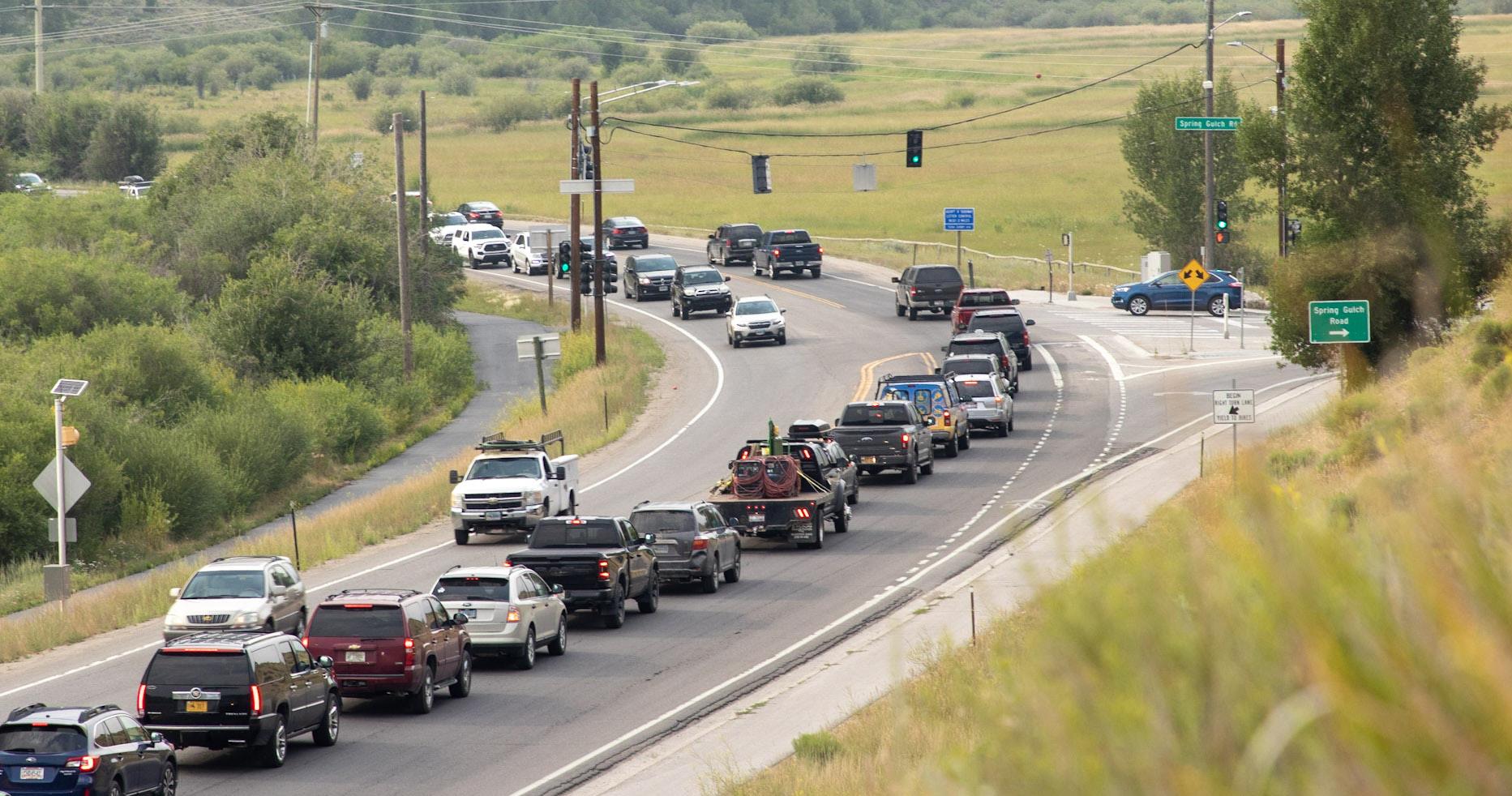
In recent years, travelers often experience big city levels of
congestion on WY-22 and WY390; both were constructed as rural two-lane highways, but are now being asked to handle as many as 4,300 cars per hour during a busy summer afternoon. This congestion has negative impacts on people who live, work, and visit Jackson Hole and impacts wildlife in the corridor, particularly:

• Wildlife crossings
• Local travelers
• Commuters
• Businesses – trouble attracting workers
At first glance, the fix may seem easy. Widen the roadways and
traffic congestion will disappear. However, as explained earlier, the science of highway management shows us that adding more capacity for vehicles to a highway already clogged with vehicles just induces more demand for driving, exacerbating all other negative externalities of auto use, and after significant investment and disruption from highway construction leaves people stuck in traffic. While there is ample scientific evidence for this phenomenon, the anecdotal evidence can be tracked by every time you’ve heard some say, “I avoid driving to Wilson in the late afternoon.”
WY-22 and WY-390 have several other unique characteristics that demand locally sensitive solutions. The graphic on the following page illustrates these issues.
 Jackson Hole Transportation Study
Commuters and vacationers traveling eastbound through Wilson on a summer morning. Congestion can extend from Jackson up the Pass west of Downtown Wilson.
Jackson Hole Transportation Study
Commuters and vacationers traveling eastbound through Wilson on a summer morning. Congestion can extend from Jackson up the Pass west of Downtown Wilson.
Realizing the Teton County Comprehensive Plan vision for stewardship, managed growth, and ecosystem preservation will require residents, businesses, and local leaders to come together to advocate a push for non-traditional solutions in the WY22 and WY-390 corridors. Case studies from cities around the Western U.S. show that simply adding auto capacity in the WY-22 corridor is certain to add traffic and move Teton County further from its goals.
Innovative, community-driven solutions start with a clear statement of intent. Our Interviews with the community and local stakeholders call for future investments that drive toward a WY-22 and WY-390 corridor that:
• Balances preservation of scenic corridor, safety for wildlife and people, and regional and interstate mobility needs.
• Considers the “roadway” as part of an ecosystem that includes residential communities, wildlife corridors, sensitive habitats and wetlands, and economic systems.
• Puts WYDOT and Teton County at the forefront of innovation in delivering a state highway project that is developed through community partnership and recognizes human, wildlife, and ecological needs.
WY-22 is a two-lane highway that cuts through the steep Teton Pass. Widening the highway west of Wilson could cost billions of dollars and have massive environmental impacts.
Solutions that move more people in vehicles are needed.
ends at a gate to Grand Teton National Park.
Beyond Teton Village demand will always be limited.
390
The intersection of WY-22 and Highway 89 – known as “The Y” - is highly constrained and a point of congestion during summer months.
Downtown Wilson is a charming place with many pedestrians and cyclists.
Slow speed tra c and improved pedestrian crossings are important to Wilson.
“Solving” challenges at The Y may mean grade separation if vehicle volumes continue to increase. Highway ramps and overpasses are incongruous with Jackson’s small-town character.
Wyoming Highway 22 runs just over 17.53 miles from the Idaho state line to where it intersects US Highway 89/191 in Jackson. Along that span it winds through a high pass of the Tetons, serves as a main street for the community of Wilson, intersects with WY-390, crosses the Snake River, and passes through ranch land before reaching the western edge of the town of Jackson.
Notable is a lack of parallel travel routes along the entirety of its course. During the summer peak travel period, WY-22 can carry over 20,000 daily auto trips. This
exceeds the functional capacity of a 2-lane highway with limited and inconsistent left-turn lanes. As such, morning and afternoon/ evening traffic congestion is a regular occurrence during peak season. Traffic demand modeling conducted for this effort shows that traffic is expected to grow by 15% through 2035 if no additional action is taken in the corridor (beyond planned and funded projects).
Four alternatives were developed and evaluated to test alternative futures for WY-22.

The four alternatives were evaluated using range of criteria that align with community and stakeholder input, the ITP, and the Comprehensive Plan vision.
Conservation
Community Character
Climate
Cost or Scale of Investment
TDM Effectiveness
Reliable Travel
Safety
Political Viability
Construction and permanent footprint of roadway

Supports walkable community scale in Jackson and Wilson
Based on vehicle miles traveled from the Teton County Travel Demand Model
Potential cost/scale of project
Supportiveness of transportation demand management measures
Reduces peak season congestion
Cross section reduces exposure risk for humans and wildlife
Jackson Hole Transportation 37
• Planned and funded projects are built including the new Snake River Bridge and new WY-22/WY390 interchange

• No other changes to the roadway are included
• New transit services to and from the Airport are added
• The currently available daily commuter bus trips to Star Valley and Teton Valley, Idaho are increased
• Local START Bus service frequencies increased by 3x
NOTE: Each alternative was modeled with and without an aggressive TDM program consistent with Move 3 Recommendations
• Planned and funded projects are built, including the new Snake River Bridge and new WY-22/WY390 interchange
• Shoulders widened and hardened to accommodate bus travel in summer
• Buses in shoulder lane attain a maximum speed of 35 miles per hour (buses only use shoulder during congested periods)
• Transit service enhancements consistent with 2035 No Build Alternative
NOTE: Each alternative was modeled with and without an aggressive TDM program consistent with Move 3 Recommendations
• Planned and funded projects are built including the new Snake River Bridge and new WY-22/WY390 interchange
• One new lane is added each way
• New transit services to and from the Airport
• Buses, vanpools and HOV 2+ (two or more people in a private vehicle) are allowed to use the HOV lane
• The currently available daily commuter bus trips to Star Valley and Teton Valley, Idaho are increased
• Local START bus service frequencies increased 3x
NOTE: Each alternative was modeled with and without an aggressive TDM program consistent with Move 3 Recommendations
• Planned and funded projects are built including the new Snake River Bridge and new WY-22/WY390 interchange
• WY-22 is widened to 4 lanes between The "Y" and WY-390
• Buses travel in general purpose traffic lane and have no priority over other traffic
• Transit service enhancements consistent with 2035 No Build Alternative
NOTE: Each alternative was modeled with and without an aggressive TDM program consistent with Move 3 Recommendations
The Teton County Travel Demand model developed by the county was used to evaluate the four alternatives for WY-22. The model was developed by Cambridge Systematics for Teton County; the same modeling team that developed the County's model conducted the analysis for this report. The travel demand model is a tool that can be used to estimate changes in how and where people travel based on future land use conditions (in this case 2035 was modeled) and what mode of travel people are likely to use (focus is on transit, HOV, or SOV). No model can predict the future, but the Teton County model is an important tool to inform local residents and stakeholders about potential future outcomes. Importantly, it is likely that WYDOT will use similar tools in its WY-22 corridor planning and environmental process. Understanding what models are likely to reveal informs future decisions and tradeoffs.
More detail on the Teton County Travel demand model is available in Appendix B.
Table 1 illustrates the major zones designated in the travel demand model and what impact a suite of TDM measures would likely have in reducing trips between zones.
After discussions with representatives of START, the 2035 transit network in the model was adjusted to reflect transit system improvements that represented implementation of the START Routing Plan (2020 – 2025) and reasonable growth in service over the following 10 years (2025 – 2035). These transit improvements include addition of service to and from the Airport. The forecast year models also increase frequency on existing fixed route bus
In Vancouver, WA, C-Tran operates bus on shoulder on State Highway 14. Buses operate on the shoulder only in congested conditions speeds are capped at 35 miles per hour.

service by a factor of three over existing service levels (less compared to full implementation of the START Routing Plan). These transit system improvements are included in all forecast year model runs, including the no-build alternative.
The speed of transit vehicles varies depending on the alternative:
• No Build: assumes buses operate in traffic and travel speeds are dictated by levels of congestion.
• Shoulder-Running Transit: assumes buses travel at a maximum speed of 35 miles per hour when utilizing the shoulder transit lane (consistent with policies set by agencies that operate running transit). Buses can travel faster when in general traffic lanes during uncongested periods.
• Transit + HOV 2+ Lane: assumes buses operate at travel speeds dictated by use and flow of the HOV lane (set by model)
• Four Lane: assumes buses operate at travel speeds dictated by use and flow of general traffic lane.
The four tested alternatives marry a range of capacity (providing more road space) and demand (shifting demand to modes other than driving alone) strategies. Modeling makes a few things clear:
• Simply adding a second travel lane per direction induced demand such that vehicle volumes increased by over 41%.
• TDM programing is critical, but when a travel lane is added, vehicle trips still increase by 28%
• A combination of restrictive capacity additions (shoulder transit or HOV 2+ and Transit) with TDM are expected to modestly reduce vehicle demand compared to today. Shoulder running transit + TDM results in a 3% reduction in vehicle volume.
As the number of people living and working in Teton County grows, as both are projected to do, demand for travel will increase. While increases in demand are inevitable, choices for how people move are results of how the transportation system is designed. Modeling makes two things clear:
• Transit can play a very meaningful role in carrying people to, from, and around Teton County.
• Adding transit capacity has modest benefit compared to combining transit capacity and demand management programming. There is a need to provide transit capacity and use incentives to increase demand for transit.
• Alternatives that include service expansion + aggressive TDM reach over 10,000 daily transit passengers during the summer peak. When peak winter ridership is considered, this level of transit ridership meets or exceeds ITP targets of 3.6 M annual riders in 2035.
Jackson Hole Transportation Study REGIONAL TRANSIT (WITH AND W/O TDM)Modeling shows that with enhanced transit service countywide, over 25% of Teton County transit trips would use the WY-22 corridor between The Y and WY-390 interchange.
This market response, combined with already high occupancy in vehicles traveling in the corridor, supports the need for solutions that provide dedicated space for transit or transit and HOVs.
A vehicle occupancy survey was conducted on WY-22 and WY-390 in February 2020. Data showed auto occupancy rates higher than national averages. For example, at a point west of Broadway on WY-22 occupancies were approximately (average of both directions):
• Weekday Mornings: 27% vehicles
2+ and 4% 3+
• Weekday Evenings: 23% vehicles
2+ and 5% 3+
• Saturday Morning: 40% vehicles
2+ and 12% 3+
• Saturday Evening: 48% vehicles
2+ and 11% 3+
Saturday data is certainly affected by ski traffic and summer data is likely to vary, but families traveling together and people carpooling to work contribute to HOV use during summer months.
High rates of occupancy on WY-22 show that travelers have already adjusted behaviors to manage congestion and challenging travel conditions. This is a strong indicator that policy and infrastructure rewarding shared-ride travel will improve the roadway operation and system efficiency.
25% 5%
2+ PEOPLE
3+ PEOPLE
Jackson Hole Transportation Study WEEKDAY VEHICLE OCCUPANCYA two-lane highway has a saturation point or a level of traffic at which even small disruptions in flow—for example, a vehicle turning—has a cascading impact and leads to congestion. Traffic signals, stop signs, and intersecting roadways or driveways all decrease the amount of traffic a lane can carry. An uninterrupted lane on an interstate freeway can carry upward of 2,200 vehicles per hour and a lane on a rural highway such as WY-22 can carry in the range of 1,700 – 1,900 vehicles per hour before becoming congested. Currently, volumes reach 2,500 vehicles per hour during summer afternoons. Congestion may set in at levels higher or lower depending on the number of intersections, whether turn lanes are provided, and the level of traffic entering or exiting the roadway.
Projected 2035 traffic volumes in the peak direction and peak hour provide a good indicator or expected congestion on WY-22. While both Shoulder Running Transit and HOV+Transit alternatives increase transit travel, Shoulder Running Transit does not increase lane capacity and, therefore, will offer less congestion relief.

WYDOT will commence corridor alternatives analysis and NEPA process starting as early as the fall of 2022. While it is easy to view highway expansion as a logical solution to a congested highway, it is important that community members understand that expansion solutions can and will worsen traffic over time, not just on WY-22 but throughout the valley. More important than advocating for a singular design and operating solution, is coalescence behind a set of outcomes. The following are core principles that should guide WY-22 planning.
• A corridor that moves people, not vehicles
• A corridor designed to optimize safety, both human and wildlife.
• A corridor that can manage seasonal peak demands through system operating solutions—e.g., transit rather than overbuilding.
• A corridor that functions as a balanced, reliable system where driving is one choice among many
• A corridor where pavement is expanded must increase mode share and decrease vehicle miles traveled. These outcomes are often at odds but don't have to be with smart planning, design, and demand management. A one-dimensional solution—adding auto capacity—will induce demand and worsen outcomes for the community over time
• A corridor designed for the average period (spring or fall) where peak demands are managed through pricing, demand management, and quality alternatives to driving.

The most important outcome of this report will be to guide local government and stakeholders in advocating for well developed alternatives in the upcoming WYDOT NEPA process. The NEPA process requires WYDOT to develop and evaluate multiple design and operating alternatives. Focusing on outcome-driven solutions can help to ensure that WYDOT considers alternatives that align with local values and the Teton County Comprehensive Plan.
Teton County, Jackson, and WYDOT should fully consider the role of transit and transportation demand management in its evaluation. Travel models often used for these efforts have limited capacity to effectively model transit ridership, the potential for cycling to capture a meaningful share of certain types of trips, or the benefits of a diverse suite of transportation demand management programs. Off-model work, such as was done for this effort, is often eschewed by highway engineers, leading to the cycle of overbuilt highways and continuing the endemic of auto-reliance. To avoid this situation, it is important that:
• START develops a long-range (2035 or 2040) service strategy. An adopted service and capital strategy for START expansion between 2025 and the planning year for WY-22 would help ensure transit’s potential is represented in the WY-22 study.
• The Town and County develop and adopt a TDM strategy that includes programmatic elements and supports proper governance and administration of such programs. Again, an adopted document will help to ensure that TDM is given credence in the WYDOT led process.
Analysis shows that both the Shoulder Running Transit and Transit+HOV alternatives improve mobility outcomes, primarily because bus travel is more viable and ridership increases dramatically due to transit speeds, reliability, and complementary TDM programming. A robust alternatives analysis process conducted by WYDOT during the NEPA analysis should include both of these options (shoulder running transit could be replaced with a transit only lane option, which is functionally identical if modeled with the tools used in this report).
 Jackson Hole Transportation Study
The following illustrate representative cross sections for the two preferred alternatives and describe key considerations and tradeoffs for each. These inform WY-22 design between the “Y” and WY-390.
• Limits new pavement
• Makes transit reliable and competitive w/ driving
• Limits visual and environmental impacts
• Does not solve peak season congestion
• Would require turn lanes, widening cross section in much of the corridor
• Does less to incentivize shared rides, vanpooling, etc.
NOTE: Given the level of analysis conducted for this report, a shoulder running transit lane and a expanded roadway with an additional transit only lane are functionally identical. It should be noted that operation of a transit only lane would require changes to state legislation.
POSITIVES NEGATIVES
• Makes transit reliable and competitive with driving
• Least congestion and lower risk for induced demand
• Optimized opportunity to manage demand, promote shared travel
• Median provides turning capacity and landscape
• Requires wider cross section
• Greater environmental impacts and disruption
NOTE: It should be noted that operation of a transit only lane would require changes to state legislation.
Jackson Hole Transportation Study
Optimizing travel and safety in the WY-22 corridor will require design improvements to key intersections that cause delay and expose travelers to risk as they enter, exit, or cross the highway. Improvements at seven key areas of focus will improve corridor operations and safety. In the following pages, we propose solutions for each of these key intersections.
• Maintain the rural character of the community.
• Use natural features to establish a gateway into the community. Formalize business access, circulation, and parking.
• Encourage active transportation modes by developing safe bike and pedestrian circulation throughout Wilson
• Prioritize human safety for all modes, including walking, biking, and driving.
• Conserve, connect, and enhance natural open space.
WYDOT plans to rebuild this interchange over multiple seasons with completion in 2025. Four new wildlife crossings will also be built, three for WY-22 and one for WY-390. Three of the crossings will be located around the 22 and 390 intersection. One will be located on the east end of the bridge made possible by a bridge extension. Pedestrian crossings are also included in the new plan with expected completion by October 2023.
The Florida T design will allow eastbound traffic to bypass the signal.
We recommend that WYDOT consider the addition of a transit-only lane on the slip ramp for the westbound movement turning onto WY-390.

 Jackson Hole Transportation Study
Looking east at the WY-22 and WY-390 intersection
Jackson Hole Transportation Study
Looking east at the WY-22 and WY-390 intersection
Left turn movements from minor roadways and ranch drives are a safety hazard and cause of congestion on WY-22. We recommend that WYDOT consider the following two primary strategies for reducing turn conflicts:
Consolidating access points to WY-22. The two tightly spaced drives south of Iron Rock present an opportunity for consolidation.
Using a roadway design that allows only right-in and right-out turn movements and provides upstream turn around opportunities, sometimes called a Michigan left. Candidates for this treatment could include:
• Pratt Road and Walton Ranch Road
• Mallard Road and Bar Y Road
While this interchange does not generate a high volume of traffic across the day, access to Teton Science School has distinct peaks that occur during rush hour. It is particularly challenging for school buses to make left turns across traffic.
Because safety concerns here involve school buses—which have slow acceleration and carry precious cargo—we recommend that a grade separated facility should be considered. The right-in, right-out access with a two-lane underpass would minimize tunneling and improve safety and mainline operations.
This design could be implemented independent of the Tribal Trail Connector (planning studies evaluated a similar design).
See page 66-67 for more on the Tribal Trail Connector
Spring Gulch Road intersects with WY22 at one of its busiest stretches. The intersection is currently signalized to allow vehicles to enter the mainline and protected pedestrians and cyclists who cross WY22. This stoplight is a major contributor to congestion on WY-22. We recommend that WYDOT consider a roundabout at this location to:
• Allow a steady flow of mainline traffic. A roundabout would create a low and steady speed as traffic enters Jackson, increasing functional capacity.
Roundabout at Spring Gulch
• Greatly reduce disruption from the Spring Gulch signal.
• Reduce wait times for southbound vehicles using Spring Gulch.

• Improve safety for all users.
• Allow the outer westbound lane to continue through uninterrupted (there is no southern leg to allow the outer HOV/Transit lane to act as a slip lane).
• Consider expanding the pathway on the southern side of WY-22 and making this the primary route from Town.
Jackson Hole Transportation StudyThe “Y” is the busiest intersection in Teton County. Recent intersection upgrades made by WYDOT have improved the function of the intersection, but it still causes congestion during peak periods, and future growth in vehicle travel will worsen mobility at this junction. Future improvements focused solely on “auto mobility” suggest solutions incongruent with Jackson’s character. A focus on moving more people, not vehicles, through this critical intersection is needed. To that end, we recommend that WYDOT consider the following:
• Connect Spring Gulch to the “Y” with an HOV/Transit lane in each direction.
• Use space preserved for slip lanes to accommodate the addition of an HOV/Transit lane

• Consider transit signal priority to allow eastbound buses to gain priority in accessing US-191.
• Prioritize pedestrian and bicycle movements for people traveling west along WY-22 to use an improved southside Pathway.

WY-390—also known as Moose Wilson Road—is a short and busy roadway that connects WY-22 with Teton Village and Jackson Hole Mountain Resort. North of Teton Village, the roadway provides access to a secondary entrance to Grand Teton National Park. Inside the park, the road is unpaved in sections. The National Park service started to improve the road north of the Granite Entrance Station in Summer 2022.
Travel on WY-390 is driven by access to Teton Village, Jackson Hole Mountain Resort, residential development along the West Bank, and access to Grand Teton National Park. Demand peaks during winter

weekend days and good snow days. The community, stakeholders, and Teton Village support an excellent set of programs to manage peak demand. Managed by Teton Village Association, TDM programs have priced and managed parking and investment in additional START bus service as foundational elements of the traffic management plan. Bus and shuttle service from Town and Stilson are highly utilized on peak days.
WYDOT is planning to rebuild the WY-22/WY-390 interchange during the 2023 and 2024 construction seasons. This project intends to reduce traffic congestion on both roadways, which is caused by the
current signal and intersection configuration. The project will include four wildlife crossings of WY22 and WY-390.

Key corridor issues to be addressed along WY390 include:
• Wildlife crossing safety. This corridor has a high number of vehicle-wildlife collisions.
Over 50 moose have died from auto strikes on WY-390 since 2008. (Top-left)
Wildlife detection and warning systems that use infrared, laser or microwave radio signals are already in use in the Greater Yellowstone area (US-191 in Montana). (Top-right)

• Speed control. High speed limits and speeding lead to increased wildlife collisions, increased severity of collisions, and decreased corridor safety for pedestrians and cyclists in the corridor.
• Uncontrolled access, including left turn movements from minor drives, contributes to congestion and is a cause/risk factor for vehicular collisions.
• Congestion is a concern during peak visitation periods, particularly during ski season. TVA, in partnership with START, has already demonstrated that bus services are the best tool for managing highly peaked ski season demands. The most significant congestion occurs between WY-22 and Lake Creek Bridge.
Jackson Hole Transportation Study Source: Josh Metten and Greater Yellowstone CoalitionRecommended solutions for WY-390 focus on management and design solutions to reduce speeds, manage turning movement conflicts, and add roadway features that act to reduce vehicular travel speeds.
• Speed control: Set limits at 35 mph night and 45 mph day; add flashing beacons that trigger when drivers exceed limits.
• Enforcement: Increase county sheriff patrols.
• Detection: Explore addition of animal detection systems with driver messaging integrated into speed signage.
• Manage demand: Implement enhanced transit and TDM measures presented in this report. WY-390 congestion is due largely to visitation and skier peaks, decreased interregional travel demand, solutions for cost-effective demand management, and resources to reduce environmental impacts.
• Consider devolution of WY-390 to County control as a mechanism to design and manage the road in line with local values, and to provide a potential one-time injection of funds to make safety improvements.
• Traffic calming and access management: A raised median and a series of roundabouts between Nethercott and Lake Creek (a less than 2-mile segment of the highway) could help to manage uncontrolled left turns, encourage drivers to enter at roundabout-controlled intersections, and provide a turn-back opportunity within 1/4 to 1/2 mile of any drive or minor access road. Treatments could be extended north, but this is the most developed portion of the corridor with the highest density of uncontrolled access.
Referred to as the "Dog Bone Concept," roundabouts in sequence combined with a center median allow the removal of uncontrolled left turns (dangerous and a cause of delay) and provide easy turn backs for drivers accessing or leaving driveways or minor roadways.

Major Access Roundabout
Minor Access Roundabout for Turn-Back
FOCUS AREA FOR ACCESS MANAGEMENT AND TRAFFIC CALMING
Roundabouts at major intersections and every 1/2 mile between Nethercott and Lake Creek
Center median requiring right-in-right-out movements
Opportunity to turn back in 1/2 miles or less (in most cases)
Access consolidation between Pony and Wiley
Jackson Hole Transportation Study Jarvis LnThe Teton County Integrated Transportation Plan proposes a new roadway (about 1/2 mile in length) that connects the Indian Trails/ Cottonwood Park neighborhoods to Highway 22. The project is identified in the Comprehensive Plan, and the County and WYDOT own most, or all the right of way needed to build the new roadway. Teton County is currently studying options for this roadway, including a range of potential intersection options to connect the roadway to the highly congested Highway 22.
The ITP states several benefits of the Tribal Trail Connector, which require further consideration and analysis.
• Improved local and regional connectivity: While the TTCR would reduce the distance between this low-density collection of neighborhoods in South Jackson and points west on WY-22 or the West Bank, the average distance of travel saved ranges around 1 mile. The ITP states that the project is intended to improve connectivity, but also indicates that it has a regional connectivity intent. This recognizes that the roadway is likely to be used for cut through traffic during congested periods.
• Removal of some local traffic from the "Y" intersection: While redundancy can be beneficial in the case of an incident, modeling shows that inclusion of the Tribal Trail Connector roadway increases overall traffic volumes on WY-22 west of the new connection and does little to reduce volumes at the "Y" intersection.
• Direct routing for START bus services connecting South Park neighborhoods to the West Bank & Teton Village: Current transit demands between South Park and points west are limited. This connection could have future value for transit, but significant development at transit supportive densities would be needed to support scheduled fixed route service. When supportive densities are realized, START and the Teton County could consider a transitonly roadway adjacent to the pathway; this would require a lesser footprint and support ITP targets to increase cycling and transit mode share.
The ITP does not address the potential safety impacts of the TTCR. Jackson schools are located along the two streets that would feed this connection from US-89.
1 2 3 4
The plan for WY-22 should focus on people-movement (not just on moving cars) and wildlife protection. To do this, the WYDOT NEPA process must use measures of performance that go beyond delay for vehicular traffic and consider all the community values delineated in the Teton County Comprehensive Plan.
All WY-22 corridor alternatives considered in the future WYDOT process should include demand management, high-occupancy vehicle or transit lanes, aggressive transit programs, and pricing.
Manage speeds for capacity and safety.
The current environment of the schools allows students to walk and bike to school safely, noting a grade separated crossing of US-89 and a low traffic environment. Increased vehicular volumes in school zones and lack of awareness from out-oftown drivers should be considered as part of the TTCR assessment.
Teton County should tether decision making about the benefits and impacts of the TTCR to the WY-22 alternatives development process. Introduction of a new intersection requiring merge movements or signalization on an already highly congested WY-22 will likely cause significant additional mainline delay.
Teton County’s planning for TTCR includes an assumption that WY22 will be a two-lane per direction cross section at the point where
the roadway intersects. Should TTCR be built prior to WY-22 improvements, which could take six to ten years in planning and design, it would force WYDOT to build an interchange that may require rebuilding in relatively short order or to make a presumptive decision about the future outcome of its WY22 alternatives analysis. Either would counter the intent of NEPA to consider a broad range of alternatives, environmental impacts, and community input.
Given WYDOT has advanced the timeline for the WY-22 study, Teton County should integrate TTCR planning with the WYDOT study to ensure corridor and transportation system outcomes are evaluated holistically.
Jackson Hole Transportation StudyNow is the time for Teton County to stop the vicious cycle of provide and predict. To get back on track toward meeting the Teton County Comprehensive Plan vision and ITP targets, local stakeholders will need to band together with a strong voice and work toward a virtuous cycle that centers decision making on wildlife and wild lands, and preserving Teton County's character and beauty for future generations. Reversing the dominant logic that people will drive and therefore our roads must be larger and faster will require strong leadership, honest discussion of tradeoffs, and willingness to make short term sacrifices for long-term gains. Local citizens, advocacy groups, and local government will need to partner, and in doing so:
The types of solutions put forward in this report require tireless advocacy, education, and broad partnerships. Core principles of demand management and multimodal system investment won’t gain immediate and resounding support. Changing people’s behavior requires education, transparent conversations about the “why,” and consistent investment.
• Broaden the conversation: while many key stakeholders are involved on Teton County transportation discussions, many people don’t have the time to tune in. Organized groups such as the Teton Transportation Coalition, which already brings together many key stakeholders, provides a great opportunity to broaden the message about why balanced solutions for WY-22 affect everyone. Take time to talk to potential opposition groups and build “unexpected partners!”
• Build public – private partnerships: limited staffing capacity at the Town and County is a commonly cited challenge. Increased transportation staffing at the County is as critical as technical staff resources to work closely with WYDOT throughout the NEPA process.
WYDOT’s multiyear process to plan and design investments for WY-22 will begin as early as Fall of 2023. Local stakeholders should strive to make demonstrable progress by the time that study gets underway.
• Lobby for the allowance of High Occupancy Vehicle and Transit Lanes: State legislative action is required to allow HOV or transit lanes to be implemented in Wyoming. This is a high priority as legislation may be needed for HOV+Transit or Shoulder Running Transit alternatives to be considered in the WY-22 study. Legislation should include options to manage highway travel lanes by vehicle occupancy and using pricing. (This strategy does not recommend highway pricing as a short-term strategy, but with advent of new technology, it could become a more viable and equitable option).
• Demonstrate demand management: Without clear evidence of demand management actions that work, it will be hard for a coalition to
promote TDM in a WYDOT led planning process for WY-22. Actions are needed sooner. The Town and County should move quickly to implement paid parking, development of a Downtown Jackson TMA, expansion of e-bike programs, and other recommendations that can start to influence peak season demand for driving.
• Fund transit: this strategy relies on continued expansion of public transportation. START has a strong track record of building a successful, community responsive transit network, but more service requires more funding. Transit operating funds must be generated largely at the local level. Expansion of transit service may the be the most critical element to preventing unnecessary highway expansion.
 Jackson Hole Transportation Study
Changing behavior is not a perfect science. It requires a test and adapt approach. Because TDM programs don’t require major permanent infrastructure, there is opportunity to pilot programs, track results, and adjust.
• Leverage disruption: Use the upcoming Snake River Bridge Construction as an opportunity to model behavior change. Make transit a viable way to bypass construction related congestion by increasing peak transit service and providing transit priority approaching the bridge during peak periods.
• Organize and act: Use Snake River Bridge mitigation and peak season visitation as impetus to form a Downtown Jackson TMA—organizing employer transportation needs – and use the TMA structure to develop TDM programs that help ensure employees and visitors from Idaho or Teton Village can reliably access Jackson.
• Build on TVA’s success: Teton County has a nation-leading model for TDM programming and can share expertise and lessons learned, building on what’s worked in Teton County!
This strategy focuses on three key travel markets: (1) employers, (2) tourists/visitors, and (3) residents.
Moving the needle for each group will require different strategies and leadership from different stakeholder groups and government organizations.
• Find employer champions: Organize Downtown businesses and large employers around a collective challenge – sustaining a workforce with an escalating cost of living. Help demonstrate that the cost of commuting –both time and money—is a major factor in where people chose to live and work. Find champions that can build support for a TMA that can tackle these challenges collectively.
• Build a Car Free Visitation Program: As local agencies turn to mitigating the impacts of high visitation, rather than promoting tourism, there is no better time than to create
programs, information, and infrastructure that allow attractive car-free visitation. Travel and Tourism, TVA, and the Chamber of Commerce should look to examples, such and Breckenridge’s No-Car, No Problem campaign and continue to work with Grand Teton National Park to develop shuttle services for visitors.
Managing demand for vehicle trips and supplying excellent travel options that compete with the auto for reliability, quality and experience is the heart of this strategy. This won’t happen overnight. Progress relies on two foundational actions:
• Price and manage parking: Mobility pricing is among the most effective tools for managing demand and reducing unnecessary auto trips. Since it is challenging and likely inequitable to price roadway use in a rural
environment, implementing paid parking for on- and off-street supply in the Jackson core area will be among the most effective means to manage demand. Managed well, paid parking can also be a tool to regulate availability, ensuring that space is available for visitors and customers.
• Develop (and implement) a long-range transit strategy: START has an aggressive growth plan in place for 2020-2025. The WYDOT process identifying future investments in Highway 22 will focus on a 20-year timeframe. It is imperative that there is a long-range plan in place for START bus services to Teton Valley, Stilson, and Teton Village. Modeling completed for this project shows that transit can play a critical role in a balanced WY-22, but it may be discounted without a clear plan in place.
Jackson Hole Transportation StudyBUILD: Better Utilizing Investments to Leverage Development; Federal grant program
HOV: High-occupancy vehicle; can be 2 or more people (HOV 2+) or 3 or more people (HOV 3+)
ITP: Integrated Transportation Plan
NEPA: National Environmental Policy Act
SOV: Single-occupancy vehicle
START: Southern Teton Area Rapid Transit
TDM: Transportation demand management
TMA: Transit management association
TMCI: Teton Mobility Corridor Improvements
TTCR: Tribal Trail Connector Roadway
TVA: Teton Village Association
VMT: Vehicle miles travelled
The “Y”: WY-22 and US-191/89 Interchange
WY-22: Wyoming State Route 22
WYDOT: Wyoming Department of Transportation
Access management: Coordinated effort to reduce the number of turn movements from a corridor to improve safety and reduce traffic conflicts and congestion.
Auto mobility: The focus on automobiles as the major form of transportation and movement.
Devolution: The process of transferring control of a roadway from one jurisdiction to another. Typically refers to transfer of a state highway to a county or city, a process which often includes a financial transaction to account for the costs of future maintenance and operations.
Dog bone concept: Roundabouts in sequence combined with a center median to allow for the removal of uncontrolled left turns.
Grade separated: A travel way that is set at a different height to distinguish it from adjacent or intersecting travel ways.
Induced demand/traffic: The proven ideology that providing more travel lanes to resolve congestion only allows more vehicle trips, which then generates more traffic and congestion.
Linked trip: A trip where a rider can complete multiple purposes and activities in one trip.
Roundabout: An intersection design treatment that requires all vehicles to progress to the right around a circular center island. Roundabout designs vary significantly.
Traffic calming: A set of interventions in a roadway designed to reduce automobile travel speeds and prevent or discourage vehicles from diverting from major thoroughfares.
Transit-oriented development: The creation of communities that are compact, walkable, mixed-use and centered around high-quality transit systems.
Transit-only lane: A roadway lane designated for use primarily by buses; can be configured to allow turning vehicles to pass through the lane.
Transit + HOV lane: A lane designated for buses and private vehicles with more than one passenger.
Transportation corridor: A significant travel way (street, road, highway) that connect centers of economic activity.
Transportation demand management: A defined set of strategies aimed at maximizing traveler choices and reduce traveler reliance on single-occupant automobile trips.
Transportation management association: Non-profit, member-controlled organizations that oversee transportation services in a particular geographic area.
Travel options or transportation options: Services, programs, and safe facilities allow people to bike, walk, take transit, share rides, and telecommute.
Vanpool: A service that allows employees to commute together using vehicles owned by an employer or private provider.
TO: Nelson\Nygaard
FROM: Cambridge Systematics
DATE: January 25, 2022
RE: SH-22 Transit Model Runs
To aid in understanding of potential transportation improvements in the WY-22 corridor between US191 / US-89 in Jackson and SH390, Cambridge Systematics has conducted several model runs evaluating corridor alternatives. This memorandum summarizes the model run assumptions and results.
The Teton County Travel Demand model is a tool developed to aid in planning for transportation improvements. Cambridge Systematics developed the Teton County Travel Demand model under contract to Teton County. A technical report was developed at the time (2019) to document the development of the model, the background assumptions used in the model development, and to provide a more detailed description of how the model functions. The Teton County Travel Demand Model Technical Report (2019) is available online and is linked here.
The basic alternative definitions are as follows:
• No-build 2035 Condition;
• Shoulder running transit; and
• HOV Lanes.
Each of these alternatives utilizes 2035 household, population, and employment growth forecasts embedded in the Teton County Travel Model. The model was also run for 2016 calibrated base year conditions for comparison to provide context. Because traffic congestion in the corridor is most pronounced during peak summer months, model results represent a summer weekday.
After discussions with representatives of Southern Teton Area Rapid Transit (START), the transit network has been adjusted to reflect transit system improvements that would better support transit in the region and the corridor. These transit improvements include
addition of service to the airport and Grand Teton National Park. The forecast year models also increase frequency on existing fixed route bus service by a factor of 3. These transit system improvements are included in all forecast year model runs, including the no-build scenario. Each scenario has been run under several conditions to better understand the range of possible outcomes in the corridor. These variations include:
• Inclusion and exclusion of a Tribal Trail connector to SH-22; and
• Inclusion and exclusion of travel demand management (TDM) assumptions intended to reduce single occupancy vehicle trips.
Scenarios that include TDM assume a defined reduction in single occupancy vehicle trips, with the amount of reduction varying by trip purpose and location. Assumed TDM trips have been removed from the roadways and re-allocated to transit in cases where transit trips are feasible. In cases where transit is not a feasible option, trip reductions are assumed to come from increased non-motorized trips or increased carpooling. TDM reduction assumptions are shown in Table 1.
The Teton County Travel model is calibrated to base year 2016 conditions and includes a 2035 forecast year dataset. The model utilizes a cross-classified trip generation model, gravity-based trip distribution model, and logit-based mode choice model. Highway traffic is assigned by time of day using equilibrium traffic assignment and transit trips are assigned for peak and off-peak conditions using TransCAD pathfinder transit assignment method.
In February of 2020 (pre-COVID), a group of Teton County residents conducted an HOV study at the intersection of SH-22 and SH-390. This study produced observed vehicle occupancy rates on a typical winter weekday. While the modeling exercise for this study represents summer conditions, data from the winter study was compared to modeled occupancy rates to determine reasonableness. This comparison showed a reasonable consistency between the observed and modeled HOV shares.
While the travel volumes are well validated in the SH-22 corridor, modeled travel speeds are not reflective of the observed delay during summertime peak hours. This is common in travel demand models, as operational issues associated with signals, driveways, and other aspects of the corridor are not fully represented in the link-based model. To account for speed differentials under the build scenarios, auto speeds in the forecast year model runs were adjusted to 5 mph. Bus speeds under
the HOV and shoulder running transit scenarios were not subject to this speed adjustment, nor were vehicles with more than 1 occupant under the HOV scenario.
A significant number of people who work in Teton County commute from households in adjacent counties, including locations in Idaho across Teton Pass. START provides commuter bus service across Teton Pass, and the travel model includes this bus service. Since this bus service is external to the travel model, ridership over Teton Pass is not sensitive to transit improvements within the model. Post processing adjustments have been made to represent an increase in usage of Teton Pass bus service under the HOV and shoulder running transit scenarios.
Scenario testing has been conducted for 17 different scenarios, including one base year (2016) scenario and 16 forecast scenarios. Table 2 and Table 3 summarize model outcomes such as vehicle miles traveled (VMT), transit boardings, highway and transit volumes, and HOV share for each scenario.
As compared to the no-build scenario, shoulder running transit produces an increase in transit riders in the corridor along with a slight decrease in regional VMT and highway volumes in the corridor. HOV scenarios show an increase in transit riders in the corridor as well as an increase in regional VMT and corridor traffic volumes.
Note: Values have been rounded to acknowledge model uncertainty. Transit ridership in TDM scenarios include a range to demonstrate the uncertainty of TDM reduction assumptions. The Tribal Trail Connector is not included in the base year 2016 scenario.
Note: Values have been rounded to acknowledge model uncertainty. Transit ridership in TDM scenarios include a range to demonstrate the uncertainty of TDM reduction assumptions.
[this page intentionally blank]