FINAL GREEN INFRASTRUCTURE STRATEGY


June 2023

TABLE OF FIGURES
2 Clarence Valley Council CONTENTS EXECUTIVE SUMMARY ................................................................................ 5 1. INTRODUCTION........................................................................................ 8 1.1. WHAT IS GREEN INFRASTUCTURE 8 1.2. WHY DO WE NEED GREEN INFRASTRUCTURE? .....................................10 1.3. ROLE OF THE GREEN INFRASTRUCTURE STRATEGY 16 2. CLARENCE VALLEY CONTEXT .............................................................. 18 2.1. POLICY CONTEXT........................................................................................21 2.2. DEVELOPMENT CONTEXT 23 3. GREEN INFRASTRUCTURE VISION ....................................................... 26 3.1. VISION 26 3.2. OUR PRIORITY AREAS 28 4. GREEN INFRASTRUCTURE STRATEGY................................................. 31 4.1. QUICK WINS – HIGH PRIORITY ACTIONS 32 4.2. ACTION PLAN...............................................................................................35
Figure 1: Greener Places principles for green infrastructure 8 Figure 2: Green infrastructure across the Clarence Valley (Top: street trees, Middle: wetland and rivers, Bottom: parks and rural lands) 10 Figure 3: Overview of green infrastructure benefits ...........................................................11 Figure 4: Benefits of green infrastructure...........................................................................12 Figure 5: Policy context in the Clarence Valley..................................................................21 Figure 6: Sutherland Shire biodiversity mapping ...............................................................41 Figure 7: Ku-ring-gai Council biodiversity mapping............................................................42 Figure 8: Urban Area Interface Model – from Central Coast Council DCP ........................44 Figure 9: Urban Area Interface Model – West Yamba Implementation..............................45 Figure 10: Wilton Growth Area DCP – typical local street section .....................................49
Figure 11: Street trees at Banyan Hill (left image after construction of housing, right, prior to construction of housing..................................................................................................50
Figure 12: Protection of street trees at Banyan Hill ensuring the street tree is outside the construction fencing 50
Figure 13: Approved Neighbourhood plan showing driveways and street tree locations at Banyan Hill 51
Figure 14: Banyan Hill House Building Design Guidelines which include requirements for at least one canopy tree
Figure 15: Footpath on both sides of a local street for a new development in Skennars
Figure 16: Highly permeability street network principles (left hand side) and example from Banyan Hill (right hand side)..............................................................................................59
Figure 17: Ballina Height urban layout (shared path shown in red) provides connectivity back to the local active recreation facilities. Right hand image shows path connecting from street back to district path network along the creek line.....................................................60
TABLE OF TABLES


GREEN INFRASTRUCTURE STRATEGY 3
51
Head 58
Figure 18 example of WSUD with minimal recreation benefits 62 Figure 19: Estimated maintenance costs for bioretention systems....................................63 Figure 20: Example of a deemed to comply OSD and rainwater tank system 64
Table 1 Current Council strategies related to green infrastructure and their status 16 Table 2 Improved governance actions 36 Table 3 Biodiversity sensitive urban design actions 38 Table 4 Street tree and tree canopy actions 46 Table 5 Parks and open space actions..............................................................................52 Table 6 Connected places actions 56 Table 7 Sustainable waterway management actions 61

EXECUTIVE SUMMARY
The Clarence Valley encourages ecologically sustainable development which supports our growing population, the creation of meaningful and sustainable job opportunities and maintains the character of our places and lifestyle that make the Clarence Valley such a great place. The Clarence Valley is part of the best region in Australia to live healthy and well-connected lives.
Our natural environment, surfing beaches, and coastal villages are rare gems that Council have responsibility to care for. We manage one of the largest Council areas on the NSW coast, with rich biodiversity, the largest river system on the east coast of NSW, and a diverse community.
The community value the natural setting which we are blessed to live in, and our existing urban areas and areas of new development need to respect and enhance the natural environment, including through incorporating measures to work with nature and maximise ecosystem services in managing our impacts on the natural environment.
GREEN INFRASTRUCTURE STRATEGY
Like traditional built infrastructure, green infrastructure is essential for providing high quality places to live. It provides a range of social, economic, environmental and cultural benefits to communities. The role of this strategy is to guide implementation of green infrastructure and support existing Council strategies which address green infrastructure in existing development. This strategy also identifies a number of priority areas to improve planning outcomes, protect and enhance biodiversity and waterway health, improve green infrastructure outcomes in new residential and employment areas, improve the provision of open space and trees, and support the walking and cycling.
This strategy will guide future land use decision making and the design of new development in the protection and provision of green infrastructure. The strategy sets the direction for an approach to green infrastructure outcomes in exiting and new development areas that best meets the needs of the Clarence Valley community over the next 20 years.
VISION FOR GREEN INFRASTRUCTURE
The Green Infrastructure Strategy plays a key role in supporting the priorities in the Community Strategic Plan – The Clarence 2032, including the principle for Valuing, respecting and actively participating in the care and management of the Clarence’s natural environment for current and future generations.
A vision for the Green Infrastructure Strategy has been developed:
In harmony with our natural environment – planning for green, liveable and connected places
GREEN INFRASTRUCTURE STRATEGY 5
IMPLEMENTING COMMUNITY PRIORITIES
Councils priorities are set out in the IP&R Framework, including the Community Strategic Plan, which provides a vision for the Clarence to be a Community of Opportunity, and how we are aiming to create a place where people are healthy, safe, connected and in harmony with the natural environment to retain and improve the quality of community life. Councils Local Strategic Planning Statement also aims to create more liveable places to improve the community’s quality of life and provide opportunities for people to enjoy our great places as well as planning for resilient and sustainable infrastructure
An important step in achieving these priorities is providing opportunities for the provision of green infrastructure. This can be achieved through land use decision making, design, operation of council assets, integration with recreation and open space planning, measures to manage natural hazards (like flooding, stormwater runoff, coastal inundation and the like), and a range of other measures
GREEN INFRASTRUCTURE IN CLARENCE VALLEY
Clarence Valley’s natural assets provide a wealth of ecological, cultural and health and well-being benefits that are crucial to our identity and future. They are a major draw-card for people to live, work and visit the area. Looking after our natural areas, and managing natural hazards, is essential for sustainable prosperity. Thus, while the Green Infrastructure Strategy is a new strategy for Council, green infrastructure isn’t something that is completely new for Council or our community. The Valley already consists of a large network of green infrastructure which Council has significant experience in managing through existing planning and maintenance practices. The strategy and implementation will enhance the awareness of and role of green infrastructure provision, and provide the policy direction and evidence to help update planning controls (like the LEP or DCPs) as well as decision making about resourcing, asset management, capital projects and other activities of Council.
PRIORITY AREAS
This Strategy has identified 6 priority areas for green infrastructure:
- biodiversity sensitive urban design
- street tree canopy cover
- parks and open space
- connected places and communities
- sustainable waterways
- improved governance
6 Clarence Valley Council
QUICK WINS
The Strategy has identified a number of high priority actions, referred to as quick-wins in each of the 6 priority areas. The quick-wins are actions that can be readily implemented and delivered based on what we already know, have a high return for their investment and have a clear alignment with the vision and objectives of the Community Strategic Plan – The Clarence 2032.
ACTION PLAN
As well as identifying quick wins there are also a range of medium to longer term actions which are part of the Strategy for each of the priority areas. These action plans will continue to build a strong foundation to inform the ongoing evolution of the way green infrastructure is planned, delivered and managed in the future in the Clarence Valley.
GREEN INFRASTRUCTURE STRATEGY 7
1. INTRODUCTION
1.1. WHAT IS GREEN
INFRASTUCTURE
We define infrastructure as the basic physical and organisational structures and facilities needed for a good quality of life. This includes infrastructure facilities and structures such as hospitals, roads, energy and water systems.
Green infrastructure is the physical and organisational structures of green spaces, natural systems and semi-natural systems. Green infrastructure includes private gardens, streets, active transport links, parks, waterways and bushland and supports liveability for the community. Green infrastructure also has different types over a range of spatial scales For example, this includes
- regional scales such as national parks and large river systems
- district scales such as large urban parks, local wetlands and nature reserves
- local scales including local parks, streets and local creeks

- micro scales such as gardens, school grounds, and community gardens
A range of different types and scales of green infrastructure in the Clarence Valley is illustrated in Figure 2
As our communities grow, retaining, enhancing and developing green infrastructure is a key goal in achieving high quality places for people to live.
The NSW Government has strategic commitments to increase green public spaces and green infrastructure This includes the Government Architects Office’s Greener Places Design Guide. Greener Places assists State and local governments to design, plan and implement green infrastructure throughout NSW. Greener Places aims to guide the planning, design and delivery of greener infrastructure to help support more sustainable places. Greener Places includes four key principles for the design of green infrastructure as shown in Figure 1.
8 Clarence Valley Council
Figure 1: Greener Places principles for green infrastructure


GREEN INFRASTRUCTURE STRATEGY 9
1.2. WHY DO WE NEED GREEN INFRASTRUCTURE?
Like traditional built infrastructure, green infrastructure is essential for providing great places to live and work Green infrastructure provides a range of social, economic, environmental and cultural benefits to communities. The natural environment of our river and river valleys, the escarpment ranges and our coastal places provide the foundation for the character of our urban areas. Having great access to quality natural public spaces is a key component of the liveability of the Clarence Valley.
Green infrastructure provides a wide range of benefits including

- contributing to and protecting the high biodiversity of our bushland, rivers and wetlands
- providing places for recreation and moving around our community
- contributing to our mental health and wellbeing
- providing ecosystem services such as filtering and slowing stormwater, cooler microclimates, improving air quality and providing habitat connectivity
- providing natural resilience to our communities including climate change adaptation, drought adaptation, providing flood protection and providing resilience to bushfires
These benefits are summarised in Figure 3 and the wide range of green infrastructure benefits are shown in Figure 4

10 Clarence Valley Council
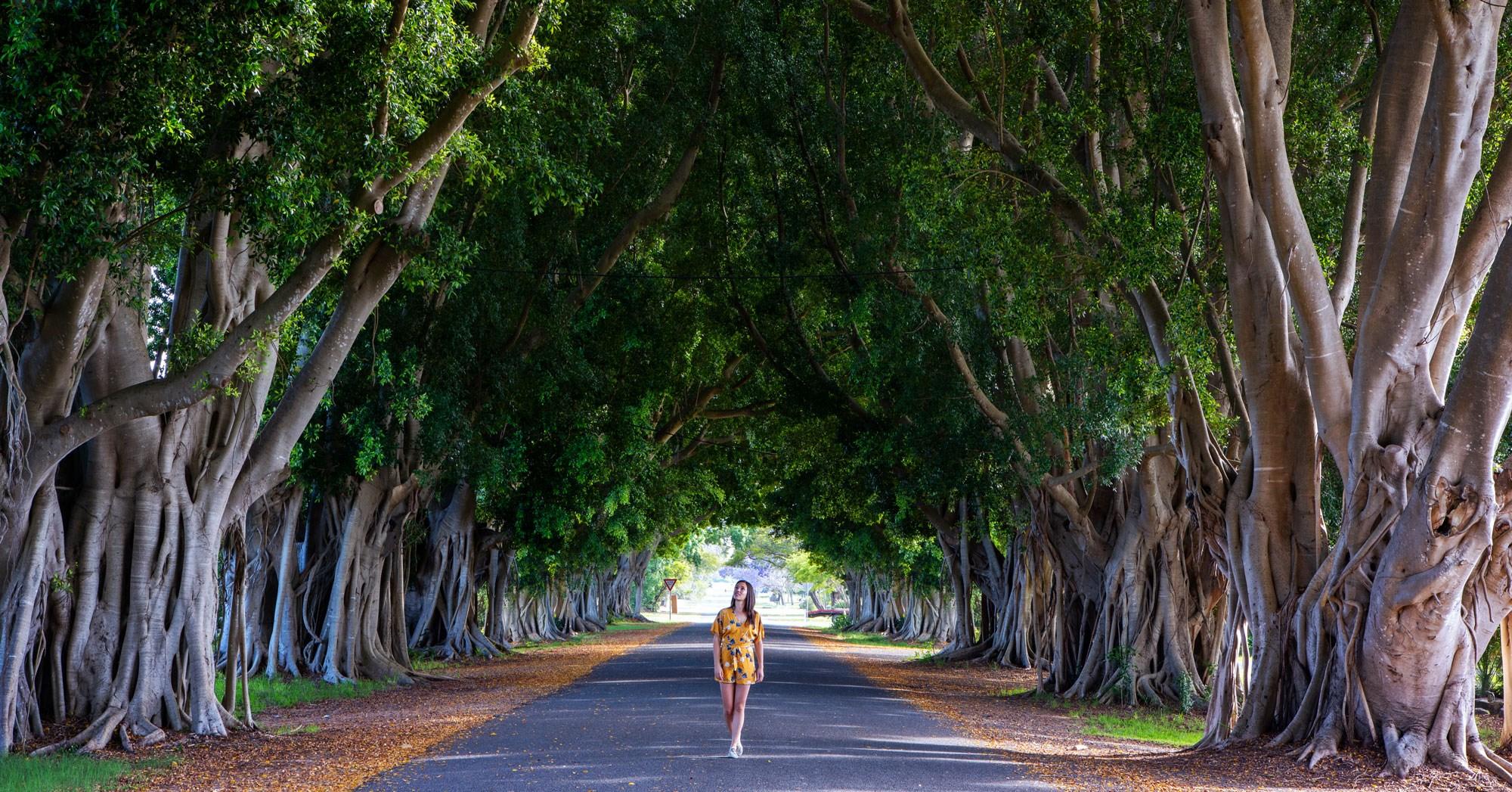
Figure 2: Green infrastructure across the Clarence Valley (Top: street trees, Middle: wetland and rivers, Bottom: parks and rural lands)

GREEN INFRASTRUCTURE STRATEGY 11
Figure 3: Overview of green infrastructure benefits

12 Clarence Valley Council
Figure 4: Benefits of green infrastructure
GREEN INFRASTUCTURE IS A MAJOR CONTRIBUTOR TO OUR COMMUNITY WELLBEING
The Clarence Valley community places a high value on the natural environment and biodiversity. The Clarence Valley’s green infrastructure provides valuable social and health benefits and a great place for recreation Consultation undertaken as part of the Community Strategic Plan clearly identified that the community recognises that green infrastructure is a big part of what makes the Clarence a great place to live and provides a wide range of natural places for people to interact with each other and with the environment. Access to green streets, parks and natural environments provides mental health benefits and a greater sense of happiness and wellbeing and also helps to reduce overweight and obesity rates and encourages and supports physical activity.
GREEN INFRASTRUCTURE SUPPORTS OUR HIGH BIODIVERSITY
The Clarence is one of the most biodiverse regions in NSW:
- approximately 50% of our local government area is national park or state forest
- the Solitary Islands Marine Park borders our southern coastal villages between Sandon and Wooli
- Iluka Nature Reserve is part of the World Heritage Listed Gondwana Rainforests of Australia
- 113 threatened flora and fauna species
- 18 threatened ecological communities and 3 endangered populations
- important habitat for endangered species including the Koala species, Coastal Emu, Black-necked Stork and the Coastal Giant Petaltail
Green infrastructure is critical in supporting and protecting the biodiversity values of the Clarence Valley through protecting habitat, enhancing ecological connectivity and connecting fragmented landscapes.
GREEN INFRASTRUCTURE SUPPORTS THE CLARENCE RIVER
The Clarence River has the largest catchment and the longest river on the NSW east coast and is our greatest natural asset. The river itself is greater than 430km in length with 10 rivers flowing into it. The Clarence River Valley is also renowned for its ecologically significant wetlands, including over 25,000 ha of nationally important wetlands.
Green infrastructure helps to protect wetlands, retain and restore riparian corridors, filter rainwater and other features across our catchment and contributes to a well functioning catchment
ECOSYSTEM SERVICES
Green infrastructure delivers a wide range of ecosystems services such as
- slowing and cleaning stormwater runoff from development
- stabilising soils and reduce erosion
- improving air quality
- contributing to healthy soils and food production
- providing space for recreation and movement through our communities
- helping to mitigate climate change including contributing to cooler communities
GREEN INFRASTRUCTURE STRATEGY 13

14 Clarence Valley Council
CONTRIBUTION TO THE ECONOMY
The Clarence Valley’s diverse natural environments and green appearance has a direct impact on our economic sustainability. The natural environment is a key factor in attracting tourists and making the Clarence a desirable place to work, live in and do business.
Green infrastructure supports the natural environment that underpins key industries like agriculture, forestry, aquaculture and tourism, as well as the wellbeing of our community and cultural connections to place. Urban development with higher quantities of street trees, parks and gardens have higher property values, and businesses located on leafy streets have higher levels of walk-in trade. Green infrastructure can also contributes to efficient use of infrastructure, for example a reduction in energy costs through provision of shading and improved microclimates.
NATURAL RESILIENCE
Green Infrastructure helps to make our communities more resilient. Green infrastructure enhances the capacity of our communities to manage the impacts of climate change and extreme weather events. It also supports our native wildlife, giving our unique biodiversity the best chance of adapting to a changing climate. Green infrastructure can also help mitigate the impacts of natural hazards, such as flooding, bushfire, coastal erosion and extreme heat Land use planning has an important role to play determining where and how development occurs across the Valley. Land use planning is key to minimising impacts on biodiversity, natural hazard risks as well as minimising the impacts on amenity and the intrinsic values of natural areas.
Droughts and devastating bushfires, which can result in rapid increases in turbidity, place pressure on our water security. Green infrastructure can support our resilience to droughts and the security of water supplies by retaining water in the landscape reducing water use for irrigation as well as through green water reuse.
FRAMEWORK FOR VALUING GREEN INFRASTRUCTURE
The NSW Government Department of Planning and Environment has released an Interim Framework for Valuing Green Infrastructure (NSW DPE, 2022). This framework can be used to undertake cost-benefit analysis of projects and programs relating to green infrastructure and public space. This cost benefit analysis can be used to support funding requests including NSW Government grant funding.
Section 3 of the framework provides a useful summary of the benefits of various green infrastructure projects. This is likely to be appropriate for smaller scale projects (for example less than $5M in construction value). Section 5 provides a detailed economic framework and provides a method to estimate a financial dollar value to the total benefits of a green infrastructure project. Section 5 of the framework is most suitable for larger scale projects (for example greater than $5M in construction value)
It is noted that many green infrastructure assets cannot be evaluated on a purely financial criteria and the valuation framework outlined above should be used with due care in decision making processes.
GREEN INFRASTRUCTURE STRATEGY 15
1.3. ROLE OF THE GREEN INFRASTRUCTURE STRATEGY
This Strategy identifies the need to create high quality liveable urban development. Urban development, including new housing and employment lands, is needed to support our growing population. Green Infrastructure is an important asset which can be used to deliver healthy liveable communities and maintain important natural environments
The role of this strategy is to support the implementation of green infrastructure in future development and to support a range of existing strategies which manage green infrastructure components. This includes maintaining the green breaks between our unique villages, protecting and linking important ecological communities and enhancing the blue-green grid in the Clarence Valley
This strategy identifies a number of priority areas including
- improve planning processes to achieve better outcomes for green infrastructure
- protect and enhance biodiversity and waterway health
- improve the provision of open space and street trees and
- support walking and cycling links
This strategy guides future land use decision making and the design of new development in the protection and provision of green infrastructure. The strategy sets the direction for an approach to green infrastructure outcomes in existing and new development areas that best meets the needs of the Clarence Valley community over the next 20 years.
Another important role of the strategy is to raise awareness of the importance and the benefits of green infrastructure in the community. The strategy also provides direction to the development industry on the outcomes that Council is seeking for green infrastructure in new development.
An important component of the Green Infrastructure Strategy is that it supports a range of existing Council strategies which also manage existing green infrastructure elements in the LGA. These strategies and their current status are shown in the table below.
Biodiversity Biodiversity Strategy 2020-25 Strategy to be updated in 2025
Urban Tree Canopy Urban Tree Management Strategy 2012
Parks and Open Space Open Space Strategic Plan 2012
Active transport
Bike Plan 2015
Sustainable Water Management Coastline Coastal Management Plan and Estuary Coastal Management Plan (CMP)
An update is being undertaking to be completed in 2023
An update of the plan will be undertaken in the next 2 to 3 years
An updated Active Transport Strategy is to be completed in 2023
Stages 2 to 4 of the CMPs are ongoing
16 Clarence Valley Council
Green infrastructure element Existing Strategy Status
Table 1 Current Council strategies related to green infrastructure and their status

2. CLARENCE VALLEY CONTEXT
First Nations communities have lived in this rich valley, enjoying food and natural resources for thousands of years. Since the mid 1800s, the Clarence Valley’s wealth has relied on our natural resources including rich alluvial soil and a favourable climate. The natural environment has been a key part of the economic drivers for the Valley including the production of timber, beef, milk, sugar and seafood. Grafton was the first city on the North Coast and this historic centre is the hub of services and opportunities for people of the Clarence Valley, supported by diverse towns and villages including Maclean and Yamba.
FIRST NATIONS
The Traditional Custodians of the Clarence Valley area are the Bundjalung, Gumbaynggirr and Yaegl nations who have a long and proud history of living in the Clarence Valley. The way First Nations peoples lived with the landscape, used fire, procured food and built an understanding of the local area can contribute to future decision making including on the values and role of green infrastructure in the Clarence Valley. The NSW State Government has outlined a Designing with Country process. This includes practical guidance on how to incorporate Aboriginal cultural heritage and First Nations people’s understanding of landscape and environment into the planning and design process for the built environment. It is becoming standard practice for new urban development to ensure that Designing with Country is part of the design and planning process
A NATURAL SETTING
National parks and natural bushland have shaped the Clarence Valley that exists today. Our natural assets provide a wealth of ecological, cultural and health and well-being benefits that are crucial to our identity and future. They are a major draw-card for people to live, work and visit the area. Looking after our natural areas, and managing natural hazards, is essential for sustainable prosperity. The natural setting is dominated by national parks and state forests, including the UNESCO World Heritage listed Iluka Nature Reserve and the Clarence River, which connects the community from its hinterlands to the coast.
A GROWING COMMUNITY
Clarence Valley is the largest local government area on the east coast of NSW, with an area of approximately 10,000 km2 Clarence Valley is located about 600 km north of the Sydney and 300 kms south of the Brisbane. In 2022, there were approximately 54,000 people living in Clarence Valley, representing 13% of the North Coast’s population, and Clarence Valley’s population is forecast to grow by 15% over the next 25 years1
1 Source: Population and household forecasts, 2021 to 2041, prepared by .id (informed decisions), November 2022 (https://forecast.id.com.au/clarence-valley)
18 Clarence Valley Council
AN AGEING POPULATION
Similar to many regional communities across NSW, Clarence Valley is undergoing a continuing demographic change. The average age of the Clarence Valley population is increasing and the proportion of younger people, in the 20s and 30s, is decreasing. To continue to provide a high quality lifestyle for the Clarence Valley, job opportunities are required to retain and attract new residents.
AFFORDABLE HOUSING
Declining affordability is affecting the sustainability of our community, including the ability to attract younger people and key workers, and enable longer-term residents to remain within their local communities A key challenge is providing housing stock that is affordable for purchase and rent to local residents. Council’s LSPS stated that in 2018 the Clarence Valley had the 5th lowest rental affordability in NSW, making it one of the least affordable places in NSW to rent.
It is also important when providing affordable housing that green infrastructure is provided as part of any affordable housing opportunities to support community wellbeing Good design which incorporates green infrastructure as an essential component encourages physical activity and supports mental wellbeing.
GREEN INFRASTRUCTURE STRATEGY 19

2.1. POLICY CONTEXT
Green infrastructure has been identified as an important element of our cities and urban areas by the NSW Government. This is represented in the NSW Premier’s Priority 11 - Greener public spaces - increase the proportion of homes in urban areas within 10 minutes’ walk of green and public spaces by 10% by 2023. The NSW Department of Planning and Environment has also developed a number of supporting strategic documents including the Greener Places Framework and Draft Greener Places Design Guide
The regional and local policy context of the Green Infrastructure Strategy is shown in Figure 5 and discussed further in the following section.
NORTH COAST REGIONAL PLAN
The North Coast Regional Plan 2041 is a 20-year blueprint for the future of the North Coast. The vision for the North Coast is to create the best region in Australia to live, work and play thanks to its spectacular environment and communities.
To achieve this vision the NSW Government has set three goals for the region:
- liveable, sustainable and resilient
- productive and connected
- growth, change and opportunity
The North Coast Regional Plan has a number of implications for council’s Green Infrastructure Strategy including providing greater housing diversity. This includes a target of 40% of new dwellings being in the form of apartments, dual occupancies, townhouses and homes on smaller lots. This target has a number of implications for green infrastructure including the need for access to quality public open space, the potential to increase urban heat and the need for enhanced active transport networks.
The Regional Plan also has a clear direction to ensure that new growth avoids hazards and avoids and minimise impacts on the natural environment including protecting areas of high environmental value

GREEN INFRASTRUCTURE STRATEGY 21
Figure 5: Policy context in the Clarence Valley
COMMMUNITY STRATEGIC PLAN - THE CLARENCE 2032
The Community Strategic Plan (CSP) is the highest level of strategic planning for Council and community. The CSP has a strong focus on community and the environment. The plan developed five key priorities and two of these priorities relates to our environment and green infrastructure
“creating a place where people are healthy, safe, connected and in harmony with the natural environment to retain and improve the quality of community life”.
“valuing, respecting and actively participating in the care and management of the Clarence’s natural environment for current and future generations”.
The CSP is supported by Council’s Delivery Program 2022/2025, which outlines a range of strategies which deliver on the priorities in the CSP. This Green Infrastructure Strategy directly supports both the priorities in the CSP as well as the strategies in the Delivery Program.
LOCAL STRATEGIC PLANNING STATEMENT (LSPS)
The LSPS is Council’s key strategic plan for a growing population and increasing jobs, providing housing, community infrastructure and an attractive environment for the community
The LSPS sets the direction for land use planning in the Clarence Valley for the next 20 years. It includes priorities to manage growth and development, protect our environment and the character of our spaces and places.
Key priorities in the LSPS include creating more liveable places to improve the community’s quality of life; providing opportunities for people to enjoy our great places and planning for resilient and sustainable infrastructure. An important step in achieving these priorities is understanding opportunities for the provision of green infrastructure through land use decision making, design, and operation of council assets, as well as its integration with recreation and open space planning.
This Green Infrastructure Strategy directly supports these priorities in the LSPS.
Council has also developed, or is in the process of developing, a number of strategies including the Local Growth Management Strategy (LGMS), Employment Land Strategy, Housing Strategy, Rural Lands Strategy; Contributions Plans and the Grafton CBD Precinct Plan. The Green Infrastructure Strategy complements these strategies and outlines the approach to managing growth and development over a 20-year period to ensure sustainable, resilient and liveable communities.
CONNECTING WITH COUNTRY
The NSW Government’s Connecting with Country Draft Framework assists in informing the planning, design, and delivery of projects in NSW. It supports the health and wellbeing of Country by valuing, respecting, and being guided by First Nations people, who know that if we care for Country – it will care for us.
The ambition of the commitment to improving health and wellbeing of Country is to help realise three strategic goals including reducing the impacts of natural events through sustainable land and water use practices, valuing and respecting Aboriginal cultural knowledge with First Nations people co-leading design and development and ensuring Country is cared for appropriately and sensitive sites are protected by First Nations people having access to their homelands to continue their cultural practices. This is now becoming standard practice in NSW in the design and planning for new development.
22 Clarence Valley Council
Priority 2 of the LSPS also includes the importance of collaborating with the Clarence Valley’s First Nations people to conserve the cultural heritage and self determination of the First Nation’s community.
2.2. DEVELOPMENT CONTEXT
GROWING COMMUNITY
Sustained growth and economic development in the NSW North Coast region, coupled with the continued attraction to our stunning environment is resulting in a growing population in the Clarence Valley Population growth over the next 20 years is forecast to be strong with:
- around an additional 9,000 people expected to be living in the Clarence Valley
- an increase in the resident population to approximately 64,000 people by 2041
Approximately 2,600 additional jobs are forecast to be created in the Clarence Valley over the next 20 years with most of these jobs to be accommodated within Clarence Valley’s employment precincts. Our growth industries are tourism, agriculture and manufacturing, with sub industry specialisations providing opportunities for our community, particularly justice and aged care.
There is increasing pressure on development in coastal zones, particularly in Yamba and Iluka. Protecting and enhancing the coastal zone’s biodiversity, its cultural heritage and its natural amenity is an important element of planning for infill and new development
KEY CENTRES
Grafton is the main commercial centre for the Clarence Valley and is a hub for regional branches of government and business. This is reflected in journey to work data for the Clarence Valley showing that approximately 87% of employed residents work within the Local Government Area (LGA). Yamba and Maclean are also important service centres to support the local community and as destinations for locals and visitors.
Key directions in the LSPS include:
- growth and development to be concentrated in our larger existing centres
- growth to be centred in urban release areas including Clarenza, Junction Hill, Gulmarrad, West Yamba and James Creek
- provision of housing choice and vibrant centres to support our main streets and villages
- development to be encouraged where it provides for a resilient and sustainable future, safe from natural hazards
- development to contribute to the character and charm of the Clarence Valley
- no additional urban release around our small coastal villages or on the floodplain.
GREEN INFRASTRUCTURE STRATEGY 23
FUTURE LAND USE
The Clarence Valley has residential land zoned to accommodate an additional 10,000 to 16,000 people If all zoned land is developed for a range of housing types this would take our population towards 70,000.
The Clarence Valley Settlement Strategy (1999) was by a sub-regional joint planning project which provided a 20-year vision for the Clarence Valley. The Settlement Strategy is still relevant today and it identified urban release areas across the Valley to meet demand while maintaining environmental values and avoiding natural hazards like flooding and bushfire. Growth was focussed on development in sewered areas close to existing services. These areas included Grafton, South Grafton, Junction Hill, Yamba and Clarenza.
The areas for new housing and employment lands and the estimated increase in population is shown on the following page.
SUSTAINABLE GROWTH
Growth needs to be managed sustainably to retain the best things we love about living in the Clarence Valley. There are a wide range of constraints that needs to be considered in future growth including maintaining, supporting and retaining biodiversity and tree canopy, resilience to natural hazards such as bushfires and flooding, infrastructure provision and costs, affordable housing and demographic changes. Key considerations to development in the Clarence Valley include significant areas of flood affected land and significant areas of bushfire prone land.
A key challenge is growing our population in an ecologically sustainable way and maintaining healthy lifestyles while providing affordable housing. This Green Infrastructure Strategy is an important step in Council’s planning to support growth which is appropriate to the Clarence Valley’s natural assets
24 Clarence Valley Council

3. GREEN INFRASTRUCTURE VISION


3.1. VISION
Two of the 5 key priorities in the Community Strategic Plan – The Clarence 2032 are:

Creating a place where people are healthy, safe, connected and in harmony with the natural environment to retain and improve the quality of community life.
Valuing, respecting and actively participating in the care and management of the Clarence’s natural environment for current and future generations.

The Green Infrastructure Strategy plays a key role in supporting the priorities in the Community Strategic Plan
The vision for the Green Infrastructure Strategy is:
In harmony with our natural environment – planning for green, liveable and connected places.
26 Clarence Valley Council

3.2. OUR PRIORITY AREAS
Priority Area 1: Biodiversity sensitive design
Our high quality natural environment underpins our lifestyle. We will plan for development that values and respects the high biodiversity of the Clarence Valley’s natural environment for current and future generations

Priority Area 2: Continuing our tradition of great street trees and canopy cover

Street trees and canopy cover provide a wide range of liveability benefits. We will ensure our existing urban areas and planning for new development creates healthy street trees which are aligned to achieving great canopy cover for our streets. Planning for street trees will consider the local character, heritage and ecological values when determining most appropriate species
Priority Area 3: Parks and open space
Parks and open space are critical green infrastructure which support community wellbeing. We will plan to ensure that the quality and quantity of parks provides equitable access which can be sustainably maintained into the future.

28 Clarence Valley Council
Priority Area 4: Connected places
Well designed networks of footpaths and cycleways underpin liveability. They provide key connections between villages, public transport, open space, schools and community facilities. We will plan for footpaths and cycleways that are interconnected, functional, well maintained and connect us to our destinations.

Priority Area 5: Sustainable waterway management

The Clarence River and our waterways are an integral part of the green infrastructure network. We will plan for green infrastructure assets that protect the Clarence River, our wetlands and our beaches and ensure that we get appropriate green infrastructure assets for the Clarence Valley which are sustainable over the entire lifecycle of the asset.
GREEN INFRASTRUCTURE STRATEGY 29
4. GREEN INFRASTRUCTURE STRATEGY
While the Green Infrastructure Strategy is a new strategy for Council green infrastructure is not new. Clarence Valley already includes a large network of green infrastructure which Council has significant experience in managing through existing planning and maintenance practices. For example, Council has a Biodiversity Strategy, an Urban Tree Management Strategy, Open Space Strategic Plan, Coastal Management Plan and the Yamba Street Tree Masterplan. All of these existing plans provide a strong starting point for the Green Infrastructure Strategy.
AN OVERARCHING STRATEGY
The Green Infrastructure Strategy is an overarching strategy to support the green infrastructure assets that Council currently plans and manages on a day to day basis. As green infrastructure encapsulates a wide range of Council assets there are a corresponding wide range of actions that Council could implement.
A TARGETED APPROACH
The Green Infrastructure Strategy, through a considered prioritisation process, identifies a number of high priority actions, sometimes referred to as quick-wins. The quick-wins identified in this strategy are actions that:
- can be readily implemented
- can be delivered based on what we already know
- have a high return for their investment
- have a clear alignment with the vision and objectives of the Community Strategic Plan – The Clarence 2032 and the priority areas in the Green Infrastructure Strategy
A key part of this approach is acknowledging that Council has to work within the budgets that are available This Strategy adopts a carefully targeted approach to green infrastructure which focuses on early wins which are achievable and which provide good outcomes for green infrastructure. This approach helps to demonstrate Council’s commitment to green infrastructure, increases Council’s capacity to manage green infrastructure and builds community support.
As well as identifying high priority actions there are also a range of longer term actions which are part of the strategy which will continue to build a strong foundation to inform the ongoing evolution of the way green infrastructure is planned, delivered and managed in the future.
GREEN INFRASTRUCTURE STRATEGY 31
4.1. QUICK WINS – HIGH PRIORITY ACTIONS
Priority Area 1: Biodiversity sensitive design
Review and update the biodiversity development controls including better measures to retain vegetation and review the approach to offsets. As part of the review develop detailed biodiversity mapping and incorporate the mapping into the LEP for existing urban and new development areas to better inform the biodiversity values.
Priority Area 2: Building on a tradition of great street trees and canopy cover Build on Council’s Urban Tree Management Strategy and Yamba Street Tree Masterplan and undertake analysis to determine the required tree sizes and soil volumes required to achieve a 40% canopy target for new development. Review the Northern Rivers Development and Design Manual and develop a locally appropriate amendment for a minimum zone for street trees within the streetscape free of utility assets.
Priority Area 3: Parks and open space
Develop new standards for the quantity and quality of open space and strategic planning of parks. The standards are to be informed by a range of life cycle costed scenarios for the quality, quantity and distribution of open space to understand the long term sustainability for Council.


32 Clarence Valley Council
Priority Area 4: Connected places
Review the Northern Rivers Development and Design Manual and develop a locally appropriate amendment for minimum standards for footpaths and cycle paths for all new streets


Priority Area 5: Sustainable waterway management
Review the Water Sensitive Urban Design (WSUD) requirements and undertake lifecycle costing of WSUD assets to understand the future cost implications and consider a deemed to comply solution which has a focus on multifunctional assets which are cost effective for Council to maintain.
Priority Area 6: Improved Governance
Improve Council’s green infrastructure planning and policy framework that clearly outlines preferred green infrastructure provisions for the Clarence Valley considering scale of development, geography, maintenance, and deemed to comply options

GREEN INFRASTRUCTURE STRATEGY 33

4.2. ACTION PLAN
A key outcome of the Green Infrastructure Strategy is to take a key role in directing the next steps to progress green infrastructure within the Clarence Valley These are key steps which lay the foundations for setting future actions including potential targets and objectives for green infrastructure components.
The action plan includes a set of actions common to all of the priority areas through improved governance and for each of the five key priority area
Each of the actions has an anticipated implementation timing which is based on a combination of anticipated ease of implementation and the priority of the action.

GREEN INFRASTRUCTURE STRATEGY 35
Table 2 Improved governance actions Action Timing
Quick-win:
Improve Council’s green infrastructure planning and policy framework that clearly outlines preferred green infrastructure provisions for the Clarence Valley considering scale of development, geography, maintenance, and deemed to comply options
1. Using Clarenza as a case study for an urban release area incorporate a costed green infrastructure plan into any new structure plan to inform contributions planning and future development
2. Using future industrial land identified at Big River Way, South Grafton as a case study for employment lands, develop a costed green infrastructure plan to inform contributions planning and future development
3. Deliver 3 green infrastructure demonstration projects that showcase a range of multi-functional and multi-purpose green infrastructure assets
4. Audit and benchmark existing green infrastructure assets (including trees, WSUD, cycleways and footpaths)
5. Investigate the need for a green infrastructure compliance and enforcement officer and development engineering officer to audit and review the implementation of green infrastructure assets
6. Take a proactive role at the masterplan/structure plan phase to ensure planning for green infrastructure, active transport links and open space corridors have adequate initial analysis undertaken. Incorporate agreed green infrastructure into site specific DCPs and development contributions
7. Take a proactive role in promoting green infrastructure in the community and in the development industry through providing training as well as capacity building in the local industry
Immediate
Immediate
Short term
Medium term
Short Term
Immediate
Ongoing
Ongoing
36 Clarence Valley Council

Table 3 Biodiversity sensitive urban design actions
Action Timing
Quick wins:
Review and update the biodiversity development controls including better measures to retain vegetation and review the approach to offsets.
As part of the review develop detailed biodiversity mapping and incorporate the mapping into the LEP for existing urban and new development areas to better inform the biodiversity values.
1. Identify high conservation areas with a focus on new development areas including urban release areas and rural residential areas based on vegetation patch size, legislative status and condition
2. Undertake a landscape scale connectivity assessment to map biodiversity corridors to avoid fragmentation of native vegetation with an initial focus on new development areas including urban release areas and rural residential areas and road reserves and incorporate the corridor mapping into the LEP and/or DCPs
3. Support biodiversity with appropriate staffing including specialist ecology and GIS skills to provide in-house technical expertise
4. Review and audit the implementation of Council’s existing Biodiversity Offset Scheme. Include a review of the success of offsetting work undertaken to date and the costs of implementation of the scheme.
5. Consider merit of CVC owned land with biodiversity assets to be conserved in perpetuity whether as a biodiversity offset, stewardship site or similar arrangement
Immediate
Short term
Short term
Immediate
Short term
Medium term
38 Clarence Valley Council
BIODIVERSITY SENSITIVE URBAN DESIGN OPPORTUNITY
There is a significant opportunity to change the way we plan for biodiversity in new development. Through mapping high value biodiversity and biodiversity corridors we can better plan for retention of native vegetation in our new developments The figure below shows the changes in native vegetation cover in Gulmarrad over the last 50 years.


GREEN INFRASTRUCTURE STRATEGY 39
EXAMPLES OF BIODIVERSITY ACTIONS
Example 1: Local Environmental Plan - Planning Controls
Sutherland Shire Council’s Local Environmental Plan (LEP) includes an Environmentally Sensitive LandTerrestrial Biodiversity clause which is a relatively standard clause and is also used in a similar manner by a number of Council’s. This clause states:
(1) The objective of this clause is to maintain terrestrial biodiversity by
(a) protecting native fauna and flora, and
(b) protecting the ecological processes necessary for their continued existence, and
(c) encouraging the conservation and recovery of native fauna and flora and their habitats.
(2) This clause applies to land identified as “Environmentally Sensitive Land” on the Terrestrial Biodiversity Map
(3) In deciding whether to grant development consent for development on land to which this clause applies, the consent authority must consider
(a) whether the development is likely to have
(i) any adverse impact on the condition, ecological value and significance of the fauna and flora on the land, and
(ii) any adverse impact on the importance of the vegetation on the land to the habitat and survival of native fauna, and
(iii) any potential to fragment, disturb or diminish the biodiversity structure, function and composition of the land, and
(iv) any adverse impact on the habitat elements providing connectivity on the land, and
(b) any appropriate measures proposed to avoid, minimise or mitigate the impacts of the development.
(4) Development consent must not be granted for development on land to which this clause applies unless the consent authority is satisfied that
(a) the development is designed, sited and will be managed to avoid any significant adverse environmental impact, or
(b) if that impact cannot be reasonably avoided by adopting feasible alternatives the development is designed, sited and will be managed to minimise that impact, or
(c) if that impact cannot be minimised the development will be managed to mitigate that impact.
Underpinning the clause is the biodiversity mapping which identifies where this land applies. Council developed biodiversity mapping for the whole LGA to inform where the control applies. This mapping includes locally ground truthed vegetation communities including Critically Endangered Ecological Communities (CEECs), Endangered Ecological Communities (EECs) and regionally significant vegetation communities. Local mapping and ground truthing of vegetation is a key part of the process because regional scale mapping is not granular enough to adequately capture all environmentally sensitive lands. Mapping procedures have been developed by various Councils (for example Sutherland, Hornsby, Ku-ring-gai and Blue Mountains) and these mapping approaches could be adopted by Council. An example of Sutherland Council’s mapping is shown in Figure 6
An important part of this approach is mapping environmentally sensitive lands (ESLs) such as koala corridors and other environmentally sensitive areas. Within the planning framework ESL is used specifically in SEPPS such as the Exempt and Complying Development Codes State Environment Planning Policy (Codes SEPP)
40 Clarence Valley Council
and provides additional protections or ‘switches off’ the Codes SEPP for complying development in these mapped areas.

GREEN INFRASTRUCTURE STRATEGY 41
Figure 6: Sutherland Shire biodiversity mapping
Example 2: Development Control Plan - Planning Controls
As well as the Local Environmental Plan mapping outlined above Ku-ring-gai Council have also undertaken detailed ‘Greenweb’ mapping which is included in the Development Control Plan (DCP), which Council periodically reviews. Council’s Greenweb mapping included core biodiversity lands (green), supporting biodiversity lands (light green) as well as biodiversity corridors (light orange) as well as landscape remnant (blue) and canopy remnant vegetation (orange). An example of this mapping included in the Ku-ring-gai Council DCP is shown in Figure 7

The mapping includes predominantly native vegetation but also includes exotic vegetation where it contributes to connectivity between core habitat and where it provides other biodiversity values.
Part 18 of Ku-ring-gai Council’s DCP includes objectives and controls which are based on the different categories within the different categories (core, support, corridor, etc).
For example, objectives for biodiversity corridors include
- to reduce edge effects to improve local ecosystems
- consolidating fragmented and linear vegetation and habitat areas
- widths of corridors should be enhanced
42 Clarence Valley Council
Figure 7: Ku-ring-gai Council biodiversity mapping
Example 3: Hornsby Councils Green Offset Code
Hornsby Shire Council has developed a Green Offset Code (the Code). The Code applies when a development is expected to impact native vegetation and provides a mechanism through which negative impacts on native vegetation at one site are offset by positive actions at another suitable site. The green offset code applies only after all other measures to avoid and minimise impact have been adopted.
The offsetting provides for three different types of offset actions:
- protection: a legal mechanism that provides for future land owners to manage the land as conservation lands through a covenant, rezoning of lands or similar. This can apply to the development land or someone else’s land
- enhance and protect: identified sites are enhanced and protected to improve their ecological integrity
- create and protect: works to create new habitat in areas adjacent to existing habitat or other identified suitable areas
The Code species the
- type of vegetation communities and offset approach (typically like for like)
- requirements for suitable land
- multipliers for different categories of vegetation
- calculation methods for offsetting
- requirements for plans, fees and guarantees
GREEN INFRASTRUCTURE STRATEGY 43
Example 4: Native vegetation urban area interface

The boundary between urban areas and native vegetation interface is a key consideration. This boundary needs to both minimise the impacts of urban development on existing native vegetation and to reduce the impacts of native vegetation on development (such as the impact of bushfires). The boundary also provides an opportunity for appropriate recreational opportunities for the communities including nature based recreation as well as active transport and micromobility opportunities.
An example of a development control that addresses the urban area and native vegetation interface area developed by Central Coast Council and included in the Council’s DCP is shown in 8. An implementation example for this which has been adopted at West Yamba is shown in 9
44 Clarence Valley Council
Figure 8: Urban Area Interface Model – from Central Coast Council DCP

GREEN INFRASTRUCTURE STRATEGY 45
Figure 9: Urban Area Interface Model – West Yamba Implementation
Native vegetation
WSUD
Road reserve
Action Timing
Quick wins:
Build on Council’s Urban Tree Management Strategy and Yamba Street Tree Masterplan and undertake analysis to determine the required tree sizes and soil volumes required to achieve a 40% canopy target for new development. Review the Northern Rivers Development and Design Manual and develop a locally appropriate amendment for a minimum zone for street trees within the streetscape free of utility assets
1. Build on the existing Urban Tree Management Strategy and the Yamba Street Tree Masterplan to set appropriate targets for minimum tree canopy for streets in new development areas
2. Build on the existing Urban Tree Management Strategy and the Yamba Street Tree Masterplan to provide street tree design guidelines, new street tree planting establishing requirements, and design specifications for new development including size and species of trees to achieve the canopy targets and minimum soil zones
3. As part of the Urban Street Tree Masterplans determine the existing tree canopy cover for existing urban areas and establish minimum targets for canopy cover on private and public land
4. Consider employing a Tree Preservation Officer
5. Develop guidelines for retention of existing native and non-native trees in new development and rural road reserves, including a review and update of the existing Roadside Vegetation Management Plans for rural areas
6. Expand the Yamba Street Tree Masterplan to other urban centres across the LGA including species lists and assessment of existing tree canopy cover
7. Review the relevant DCPs to consider inclusion of appropriate landscaping guidelines and related planting requirements for all new development
Immediate
Immediate
Immediate
Immediate
Short term
Short term
Medium term
Short term
46 Clarence Valley Council
Table 4 Street tree and tree canopy actions
STREET TREE CANOPY COVER OPPORTUNITY
There is a significant opportunity to retain existing trees and plan for better street trees in new development areas in both residential and employment lands to achieve increased canopy cover in both the streets and private lots. The figure below shows the canopy cover in new employment lands (Yamba) and new residential developments (Townsend).


GREEN INFRASTRUCTURE STRATEGY 47
EXAMPLES OF STREET TREE CANOPY ACTIONS
Example 1: Wilton Growth Area DCP 2021 – street cross section
Wilton is a significant new growth area in Greater Sydney with a new town centre, employment lands and more than 9,000 new homes proposed as part of the growth area. Wilton is located about 80km south west of Sydney’s central CBD and 40km from Mittagong in the NSW southern highlands.
The Wilton Growth Area Development Control Plan (DCP) was developed so that new development is consistent with the vision of creating a liveable new place in the natural environment.
A part of the DCP, section 3.5 has controls on street trees including
- target to achieve 40% tree canopy
- prioritising retention of existing trees
- street tree species list including preference for diversity of planting
- acceptable locations (for example not located in carriageway)
- adequate space including clearances and root barriers
- sufficient space for the tree and consideration of deep soil zones and water source for trees
- minimum tree pot size (100L)
A key part of the Wilton DCP (section 3.14) is the provision of typical spatial allocations and street cross sections for the road reserve. Plans and sections are shown for a range of road types including sub-arterials, collectors, local streets and laneways are provided in the DCP
An example of a local street is shown in 10. This figure shows that:
- a minimum dedicated space for trees has been allocated on both sides of the street
- a dedicated shared services trench has been identified on each side of the road, outside of the street tree zone
- minimum width 1.5m footpaths have been provided on both sides of the street
48 Clarence Valley Council

GREEN INFRASTRUCTURE STRATEGY 49
Figure 10: Wilton Growth Area DCP – typical local street section
Example 2: Street tree implementation during development phase
The Banyan Hill development in Ballina provides an example of implementation of street trees in a new development (refer Figure 11) Although the previously existing trees and vegetation were removed as part of site preparation a number of components were implemented and provide some lessons for other subdivision development:


- an indicative street and lot plan which shows an approved driveway location and adequate clearances from street trees for each individual house builder/owner (refer Figure 13)
- changes from the approved driveway location require separate approval
- implementation of street trees at the initial earthworks and civil construction stage and protection of trees through staking of the trees (refer Figure 12)
- 1.8m construction fencing for individual lots does not extend beyond the footpath and the street tree is separated from the house construction site (refer Figure 12)

- design guidelines including requirements for at least one medium to large canopy tree in the front yard (refer Figure 14)
- design guidelines including recommended tree species (refer Figure 14)
50 Clarence Valley Council
Figure 11: Street trees at Banyan Hill (left image after construction of housing, right, prior to construction of housing
Figure 12: Protection of street trees at Banyan Hill ensuring the street tree is outside the construction fencing


GREEN INFRASTRUCTURE STRATEGY 51
Figure 13: Approved Neighbourhood plan showing driveways and street tree locations at Banyan Hill
Figure 14: Banyan Hill House Building Design Guidelines which include requirements for at least one canopy tree
Table
Action
Quick wins:
Develop new standards for the quantity and quality of open space and strategic planning of parks. The standards are to be informed by a range of life cycle costed scenarios for the quality, quantity and distribution of open space to understand the long-term sustainability for Council
1. Review the provision of parks and open space in recent new development areas, including quality and level of facilities, and benchmark against open space planning guidelines
2. Develop landscape design guidelines which identifies locally appropriate, robust soft and hard landscape palette to achieve long term sustainability of park maintenance
3. Develop guidelines for the appropriate provision of multi-functional parks and open space co-located with other green infrastructure including WSUD, active transport, waterways and biodiversity
4. Audit existing parks and open space canopy cover and develop canopy targets for parks and open space
Timing
Immediate
Short term
Medium term
Medium term
Short term
52 Clarence Valley Council
5 Parks and open space actions
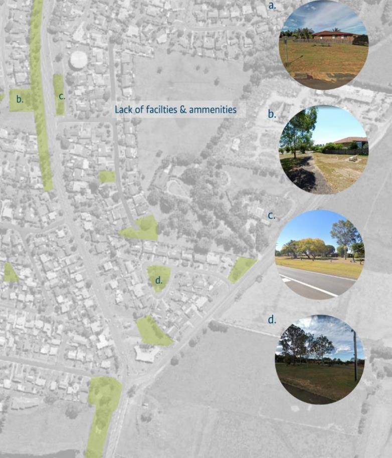
PARKS AND OPEN SPACE OPPORTUNITY
There is a significant opportunity to diversify the provision and facilities of parks and open space in new development. This recognises the need to cater for the changes in demographics and the changing recreational needs of our community. The figure below shows the provision of approximately 10 different small open space in Junction Hill. Each of the parks has limited recreation value with minimal facilities or embellishment There is the opportunity to consolidate the open space, locate this open space centrally within the precinct and provide open space with facilities which meets the diverse needs of the community and is more sustainable for Council to maintain. Larger consolidated open space can also retain existing trees and native vegetation to provide for amenity as well as urban biodiversity within the consolidated parkland.
GREEN INFRASTRUCTURE STRATEGY 53
EXAMPLES OF PARKS AND OPEN SPACE OPPORTUNITIES
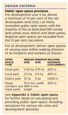
Example 1: Design criteria for public open space provision
The NSW Government developed a Draft Urban Design Guide in 2021 to inform good design outcomes for new urban developments in NSW. As part of this guideline there was recommended provisions for allocation and location of public open space. These provisions are shown in the text box on the right. Key components of this public open space provision were:
- applied to development greater than 5 hectares in size
- a minimum of 15% of the development be provided as open space
- median size of public open space is 0.45 Hectares for a small park and 2.5 hectares for a local park
- provides for recommended access to public open space to promote accessibility and to encourage access through walking and active transport
The guidelines also note that the 15% open space criteria can be partially met through existing open space located outside the development boundary, subject to a local merit assessment. Any considered public open space must be within walking distance of the development, consistent with design criteria for this objective.
It is recommended that Council consider setting, for developments over five hectares in size, a locally relevant:
- minimum area of open space to be provided as part of new development for developments
- minimum size of open space for different categories of park (small, local, district, etc)
- opportunities for this to be provided as part of existing open space where good connectivity is provided to this existing open space to the new development
54 Clarence Valley Council
Example 2: Provision of a diversity of recreation in open space
The NSW Government developed a Draft Greener Places Design Guide in 2020 to inform good design outcomes for new public open space in NSW. This guideline identified a range of different types of outdoor recreation (“program”) that could be provided in parks. These types are shown on the right. It is not only the provision of the quantity of open space that is important. Large quantities of poor quality open space are less likely to be used by the community and are more expensive to operate and maintain. Hence as well as providing development controls for the quantity of open space, the Greener Places Guide outlines that the quality of open space is also important. A key factor underpinning the quality of open space is the provision of outdoor programs and facilities for the community.

The Guide notes that a key principle is multi-use of recreation space and while not every recreation opportunity or program is possible in every open space, public open space should provide for a diverse range of locally appropriate programs to cater for a diverse population in one single space.

The Greener Guide also provides detailed design guidance including appropriate uses, examples, and performance criteria in the Guide
GREEN INFRASTRUCTURE STRATEGY 55
Table 6 Connected places actions
Action Timing
Quick wins:
Review the Northern Rivers Development and Design Manual and develop a locally appropriate amendment for minimum standards for footpaths and cycle paths, incorporation vegetation and shade, for all new streets.
1. Undertake a high-level review of 3 to 4 recent developments to review the walkability and overall accessibility for a diverse population
2. Working closely with the Active Transport Strategy review the level of footpath provision and walkability in new development areas and identify gaps in the existing pedestrian network and provide recommendations for additional path infrastructure
3. Working closely with the Active Transport Strategy and with a particular focus on new development areas consider provision of cycle networks between villages and between new development areas and key destinations (town centres, schools, etc)
4. Review the planning proposal requirements and DCPs to consider the requirement for pedestrian and cycling infrastructure for all new urban release areas
5. Review and amend the DCPs to require appropriate end of trip facilities for active transport in new developments
Immediate
Short term
Immediate
Short term
Medium term
Short term
56 Clarence Valley Council
CONNECTED PLACES OPPORTUNITY
There is a significant opportunity to improve the permeability and legibility of the street network to provide for improved walkability in new development areas. Providing a block network with block lengths of approximately 200m delivers a highly permeable and legible urban environment and promotes walking and cycling. Central Grafton’s street network around Clarence and Kent Streets exhibits high permeability with consistent 200m blocks

GREEN INFRASTRUCTURE STRATEGY 57
EXAMPLES OF CONNECTED PLACES ACTIONS
Example 1: Provision of footpaths


The NSW Government developed a Draft Urban Design Guide in 2021 to inform good design outcomes for new urban developments in NSW. The Design Guide recommended infrastructure provisions to prioritise walking and cycling infrastructure for people of all abilities Within the Design Guide is a “design criteria” for the provision of dedicated footpaths in new development on both sides of street carriageways This shown in the text box on the right, and example in Figure 15

The desired provision of footpaths is included in street cross section in DCPs for urban release areas. For example, the cross sections for Wilton Growth Area DCP shows that all local streets have 1.5m minimum width footpaths on both sides of the street (as shown in Figure 10)
It is recommended that Council consider footpaths on both sides of the street for all new streets in new development areas and as a minimum consider a footpath on one side of all news streets for all new developments.

58 Clarence Valley Council
Figure 15: Footpath on both sides of a local street for a new development in Skennars Head
Example 2: Permeable blocks and connectivity
The NSW Government and Transport for NSW developed the Network Planning in Precincts Guide in 2022. This Guide provides strategic design and planning of transport networks to support 15 minute neighbourhoods and 30 minute cities.

A key principle in the Precincts Guide was that provision for pedestrians and micromobility was to be considered first and before other forms of mobility (such as motor vehicles). It recommends developing a street network that encourages walking and cycling and public transport journeys It also recommends a permeable network with a grid like structure, short block length and high intersection density. This is shown in Figure 16 Shade and use of vegetation also needs to be carefully considered as an integral part of the design.
The Network Planning Guide recommends:
- grid like or modular structure with good interconnectivity and predictable layouts
- block lengths in greenfield developments of 120 to 180m with block perimeter of 360m
- more than one intersection per hectare

- adopts filtered permeability providing connectivity for pedestrians and cyclists but restricts motor vehicles
- dedicated walking and cycling facilities
GREEN INFRASTRUCTURE STRATEGY 59
Figure 16: Highly permeability street network principles (left hand side) and example from Banyan Hill (right hand side)
Example 3: Connectivity into district and local networks
Connectivity from new developments into district and regional walking and cycling paths significantly contributes to encouraging and promoting walking and cycling. Inclusion of walking and cycling routes which provide clear linkages from new development to key local destinations, such as schools, active sports facilities, town centres, and foreshore and waterway corridors, is an important component of the urban development layout.
Network Planning in Precincts Guide Principle 5 is for connected direct and comfortable walking and cycling movements. This is shown in the image on the right which shows:

- a permeable local street network
- a dedicated walking and cycling only link centrally in the network
- connectivity back to walking and cycling links along waterway and similar corridors

Figure 17 shows an example of district connectivity at Ballina Heights A walking and cycling network has been dedicated on the south and west of the development. While not located centrally, the location has the advantage of providing a route with minimal road crossings which provides a safe and easy to use route for younger children. This link connects into a district shared path network that provides connectivity into the local district active recreation facility.

60 Clarence Valley Council
Figure 17: Ballina Height urban layout (shared path shown in red) provides connectivity back to the local active recreation facilities. Right hand image shows path connecting from street back to district path network along the creek line
Table 7 Sustainable waterway management actions
Action Timing
Quick wins:
Review the Water Sensitive Urban Design (WSUD) requirements and undertake lifecycle costing of WSUD assets to understand the future cost implications and consider a deemed to comply solution which has a focus on multi-functional assets which are cost effective for Council to maintain.
1. For all new development areas including urban release areas and rural residential areas, review the sensitivity of the downstream receiving waters to urban development, particularly where a development drains to a low sensitivity receiving water
2. Develop low maintenance, deemed to comply, WSUD solutions, including updating the DCPs, with a focus on rainwater tanks and passive irrigation of street trees to meet water quality targets for new development in small developments, rural residential, infill developments, and for new development draining to low sensitivity receiving waters
3. Review existing WSUD assets and project future WSUD assets, including riparian lands and waterways. Develop a projection of maintenance costs for WSUD green infrastructure for the next 20 years for existing and future WSUD and riparian and waterway assets.
4. Develop an asset register and audit of WSUD assets and develop a process for new development assets to be captured in the register
5. Develop guidelines for the appropriate provision of multi-functional WSUD green infrastructure including appropriate maintenance access
6. Run capacity building workshops for operation and maintenance of WSUD assets for Council maintenance staff responsible for maintaining WSUD assets
GREEN INFRASTRUCTURE STRATEGY 61
Immediate
ongoing
Immediate
Immediate
Immediate
term
Medium
term
Short
SUSTAINABLE WATERWAYS OPPORTUNITY
There is a significant opportunity to provide for multi-purpose WSUD green infrastructure assets. Providing passive recreation opportunities including walk paths, seats, tree planting and simple nature play elements can add significant community value to green infrastructure assets. Figure 18 shows a WSUD basin which is located at the back of the development with limited access by the public and minimal opportunities for the community to engage with and benefit from the green infrastructure asset.

62 Clarence Valley Council
Figure 18 example of WSUD with minimal recreation benefits
EXAMPLES OF SUSTAINABLE WATERWAYS ACTIONS
Example 1: Lifecycle costing and planning for maintenance of WSUD assets
WSUD assets are being constructed as part of new development to meet Council’s water management development controls. WSUD assets include a diverse range of infrastructure including gross pollutant traps, end of pipe bioretention systems, infiltration systems, wetlands, swales and streetscape raingardens. As these assets are relatively new to Council, asset management teams are less familiar with these assets and the associated costs of maintenance. Furthermore, these new assets require budgets to be allocated to maintenance teams to enable these assets to operate as they are intended to. An important part of this is to understand the lifecycle cost of WSUD assets that are being dedicated to Council.
The ACT Government implemented a waterway health improvement program. This project constructed $100 million in new WSUD assets. To understand the maintenance implications, the ACT Government undertook a life cycle costing exercise (for example refer Figure 19). This life cycle costing used two methods to determine the lifecycle cost. The first was to use existing data that had been captured by the broader industry. It also used an itemised bill of quantities approach collaborating with ACT Government staff to estimate the hours of staff and machinery and equipment required to maintain WSUD assets. This information was then used to inform future budgets to be allocated to the assets. It also informed the type of assets that were preferred by Council’s maintenance teams.

GREEN INFRASTRUCTURE STRATEGY 63
Figure 19: Estimated maintenance costs for bioretention systems
EXAMPLES OF SUSTAINABLE WATERWAYS ACTIONS
Example 2: Deemed to comply solutions
New WSUD infrastructure is being constructed as part of developer’s commitments to meet Council’s water management developments. A key opportunity for Council is for small scale development and infill development as well as those areas which are which are draining to less sensitive waterways (i.e. developments such as Junction Hill which drain directly to the Clarence River) there is the opportunity to implement simpler deemed to comply solutions for water quality. This could include for example a deemed to comply solution for rainwater tanks which outlines:
- minimum rainwater tank size

- minimum end use connections (for example plumbed internally to laundry, toilets and outdoor uses)
- minimum roof area to be connected
- overflow from rainwater tanks to on site infiltration systems (where appropriate)
This could then be used in place of end of pipe water quality basins and would make it simpler for developments to meet the water quality requirements and would focus Council WSUD assets and investments on those receiving waters which are sensitive to urban development.
64 Clarence Valley Council
Figure 20: Example of a deemed to comply OSD and rainwater tank system
GLOSSARY
CEEC – Critically Endangered Ecological Community
CMP – Coastal Management Plan
CSP – Community Strategic Plan
CVC – Clarence Valley Council
DCP – Development Control Plan
DPE – Department of Planning and Environment
EEC –Endangered Ecological Community
ESL – Environmentally Sensitive Lands
LEP – Local Environment Plan
LGA – Local Government Area
LSPS – Local Strategic Planning Statement
OSD – On site detention
SEPP – State Environmental Planning Policy
WSUD – Water Sensitive Urban Design
GREEN INFRASTRUCTURE STRATEGY 65

