
2 minute read
4.2.9 Public Works


❑ Work with the County and Community Services to implement the Transit Outreach template solution. ❑ Implement ArcGIS StoryMaps to promote parks and special events. ❑ Implement the Color Basemap and Canvas Basemaps for improved public display.
Parks and Recreation Solutions
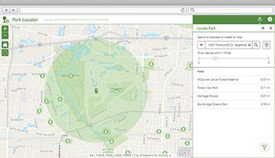
Park Locator
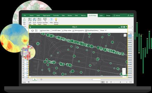
Esri Maps for Office Public Parking


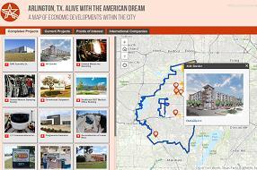
ArcGIS StoryMaps
4.2.9 Public Works 4.2.9.1 Top Priorities • Accuracy of asset locations for stormwater • Stormwater network tracing • Streetlight inventory, maintenance, and LED upgrade progress
4.2.9.2 General Comments Generally, GIS is primarily consumed through paper maps produced by Imrul, though there are a number of business systems with potential points of integration. Duplicate data entry between systems is identified as an issue. With the exception of Lucity for asset management, any insights gained from information in other systems (Munis, FASTER, Interlusion, Sunovia, FuelMaster) are provided through manual processes. This is especially surprising for the Munis work order system. Work order information is conveyed through address lists rather than geographically. Fixed route stops are similarly managed through spreadsheet for complaints, rather than maintenance. The Solid Waste “Keep the Beauty” campaign has opportunities for public outreach and Smart City initiatives. Capital improvement project estimation and scheduling could be better coordinated and communicated through an intradepartmental web solution with potential limited access for the public. As with other departments, an authoritative address list is lacking and desired.
4.2.9.3 Recommendations ❑ Ensure access to centralized spatial datasets and web mapping applications. ❑ Work with other departments to locate or develop datasets for desired features (e.g. street centerlines, streetlights, landscaping, rights of way, easements). ❑ Work with other departments to generate a single authoritative addressing database.
Perform validation for other business systems (especially Munis). ❑ Initiate a formal data review process (errors and omissions). Prioritize those having the greatest operational impact. ❑ Implement the AG4LG Map Change Request app to assist data review, especially for missing attributes. ❑ Review the Esri ArcGIS for Local Government (AG4LG) public works solutions: https://solutions.arcgis.com/local-government/public-works/ ❑ Implement components of the AG4LG Capital Project Planning Solution: https://storymaps.arcgis.com/stories/46920fd28c014f08977a6fc64ce1804f ❑ Review and implement AG4LG street asset inventory solutions ❑ Configure the AG4LG Emergency Management Maps template for paper backups. ❑ Integrate GIS with Munis to access tree removal permits and other permitting information. ❑ Consider the Daily Activities Dashboard to visualize work orders geographically. Some functionality may be accomplished using Lucity Mobile and Lucity Live Work Orders, already planned for implementation.


