1 minute read
4.2.8 Parks and Recreation


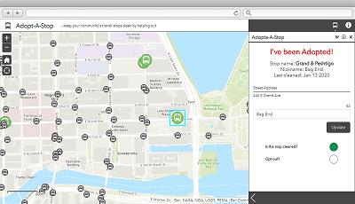
❑ Configure AG4LG Adopt-A-Stop application to promote and track sponsorship opportunities. ❑ Promote sponsorship opportunities through StoryMaps and Adopt-A configuration in order to create a potential revenue stream. ❑ Continue to leverage specialized vendor support for microtargeting and geotargeting campaigns. ❑ Consider implementing the Connector for Twitter - GeoEvent Server to monitor public tweets tagging the City, create associated maps, and alert Marketing and other groups.
Marketing and Public Relations Solutions
Adopt-A-Stop


ArcGIS StoryMaps
4.2.8 Parks and Recreation 4.2.8.1 Top Priorities • Access to park amenities information • Provide ADA-compliance information • Reduce dependency on Excel and paper
4.2.8.2 General Comments Parks manages a number of facilities but is primarily focused on special events. The Director would very much like to see improved tracking and access to amenities information. Most information is tracked in Excel spreadsheets. Programs are influenced by proximity to transportation stops. Without demographic information, some good program ideas are unsuccessful due to the location. Parks would like to gain more information on their participation rates especially from City residents.
4.2.8.3 Recommendations ❑ Ensure access to core spatial datasets and web mapping applications. ❑ Work with other departments to locate or develop datasets for desired features (e.g. park boundaries, park amenities, irrigation, playgrounds, pavilions, schools, trails). ❑ Develop a polygon-based park boundary layer with amenities. ❑ Implement the AG4LG Park Locator solution template. ❑ Implement the AG4LG Public Parking solution template. ❑ Review the AG4LG Street Tree Inventory mobile application. ❑ Use ArcGIS Online to display and manage pavilion rental information for internal and public use. Include links to the VSI system for registration and rentals. ❑ Leverage Esri Maps for Office to create and publish maps directly from Microsoft Excel.
Consider moving data into GIS feature classes.


