



ADOPTED JANUARY 14, 2014
WARDS FERRY ROAD CORRIDOR STUDY
–FINAL REPORT
Lynchburg, Virginia
June 2013


ADOPTED JANUARY 14, 2014
–FINAL REPORT
Lynchburg, Virginia
June 2013

Prepared for: Region 2000 Local Government Council Lynchburg, Virginia
Prepared by:
URS CORPORATION Richmond, Virginia
The contents of this report reflect the view of the author(s) who are responsible for the facts and accuracy of the data presented herein. The contents do not necessarily reflect the views or policies of the Federal Highway Administration and/or the Commonwealth of Virginia Transportation Board. This report does not constitute a standard, specification or regulation. FHWA acceptance of this report as evidence of fulfillment of the objectives of this planning study does not constitute endorsement/approval of the need for any recommended improvements nor does it constitute approval of their location and design or a commitment to fund any such improvements. Additional project level environmental studies of alternatives may be necessary.
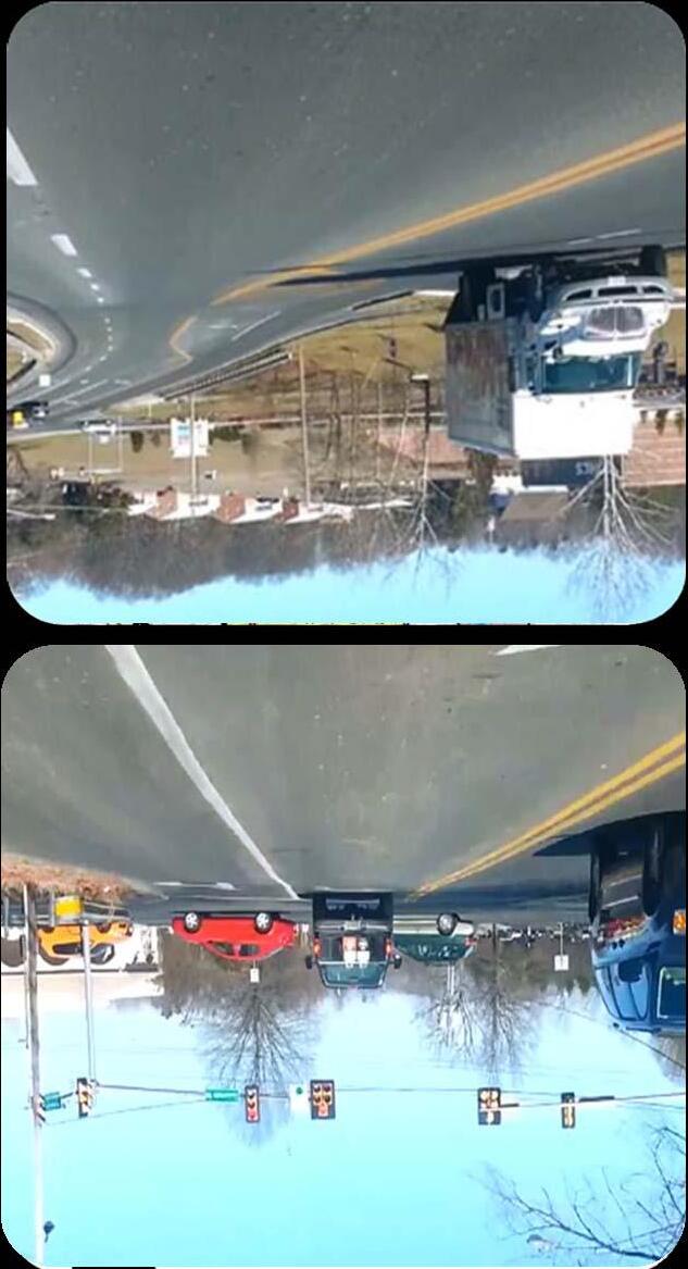
The Region 2000 Local Government Council - the Central Virginia Metropolitan Planning Organization (MPO) - engaged URS Corporation to develop the Wards Ferry Road Corridor Study. The Wards Ferry Road corridor connects from Timberlake Road in the north to Wards Road in the South. Timberlake Road and Wards Road are both major gateways in the City of Lynchburg. Wards Ferry Road serves as a heavily used collector facility that provides access to residential, commercial, and institutional uses.
Several major projects will influence the demands and function of Wards Ferry Road. First, an ongoing study at the corridor’s northern terminus - Logan’s Lane Traffic Study will be conducted during the summer 2013. Second, proposed changes to Heritage High School can have significant impacts on Wards Ferry Road traffic volumes, particularly in the a.m. peak hour. Third, the proposed tunnel from Liberty University to Harvard Street, which will provide a more direct connection from Liberty University to the Wards Ferry Road corridor. Finally, a moderate amount of undeveloped or under-developed land adjacent to the Wards Ferry Road corridor has the potential to place additional traffic demands on the roadway and intersections.
The purpose of this corridor study has been to provide the MPO and local government with a detailed planning level assessment of the options for future roadway needs. It provides conceptual alternatives for the MPO to consider. Ideally, the study has provided the MPO and the City with recommendations that can be incorporated into local plans and policies so that the preferred alternative can be implemented.
Volumes and Service Levels: A review of published VDOT traffic volume along the Wards Ferry Road corridor indicates high traffic volumes for a two-lane facility. Weekday volumes in 2011 ranged from 9,400 to 11,000 vehicles per day. Comparing these recent counts to historic counts reveals moderate amounts of growth, 1.3%-3.6% annual growth, taking place in the past five years.
Peak period turning movement counts were conducted at 6 intersections with Wards Ferry Road – Timberlake Road, Adams Drive, Harvard Street, Atlanta Avenue, Simons Run, and Wards Road. Additionally, daily directional traffic counts were also conducted at three corridor locations –immediately south of Adams Drive, immediately south of Harvard Street, and immediately north of Simons Run.
Capacity analysis showed that the three signalized intersections with Wards Ferry Road –Timberlake Road, Simons Run, and Wards Road operate with adequate levels of service. Capacity analysis for two of the three unsignalized intersections – Adams Drive and Harvard Street exhibit poor levels of service from the minor street approaches. Atlanta Avenue operates with adequate service levels.
Wards Ferry Road as a facility was also analyzed using Highway Capacity Manual methodologies. In the a.m. peak hour most segments of the corridor operate with LOS B and LOS C conditions which are considered adequate. During the p.m. peak hour the service levels deteriorate to LOS D conditions for most of the segments. LOS D conditions are considered moderately adequate.
Safety: A three-year history of crash records was reviewed (2010-2012). There were a total of 72 crashes that occurred on the corridor during this period. Crash records show the most frequent types of crashes involved rear-end collisions – 41 and angle collisions – 20. These types of crashes can be attributed to geometric issues (horizontal and vertical curvature), frequent access points, an absence of turn lanes, and driver inattentiveness.
A scan of environmental resources in the Wards Ferry Road corridor study area was conducted using available GIS resources, and known resources were mapped. This inventory does not indicate the presence of any constraints that are likely to compromise the ability of the City to implement recommended actions.
No Build Alternative: Forecasts of year 2035 traffic volumes were developed using the Year 2035 Lynchburg Regional MPO travel demand model. After adjustments were made to the modeling output Wards Ferry Road corridor was forecast to grow 25% by the Year 2035 over existing volumes.
When compared with existing conditions, forecasted service analyzed under the year 2035 No Build Alternative deteriorates by approximately one letter grade. The most severe deterioration is forecast to occur at the unsignalized study area intersections – Adams Drive, Harvard Street, and Atlanta Avenue. Each of these three intersections is forecast to have the failing service levels in the p.m. peak hour for the minor street approaches. Poor service levels are due to forecasted traffic volumes on Wards Ferry Road becoming sufficiently high so that adequate gaps in the traffic stream will be less frequent, and motorists on the minor street approaches will encounter increased delay before safely entering the traffic stream.
The three signalized intersections on the corridor – Timberlake Road, Simons Run, and Wards Road are forecast to continue operating with adequate service levels. The growth in traffic volumes did cause moderate increases in delay over existing conditions.
Analysis of forecasted conditions for Wards Ferry Road as a facility showed moderate amounts of degradation in service levels when compared to the existing conditions. In the No Build Conditions the a.m. peak hour begins to see LOS D conditions in the peak direction of travel at all three segments. During the forecasted p.m. peak hour conditions there are LOS D conditions as was found in the existing conditions.
The purpose and need for the Wards Ferry Road Corridor Study is defined as addressing the following issues:
1. Frequencies of crashes along Wards Ferry Road have the potential to increase as traffic volumes and development pressures increase;
2. Service levels in the area of three intersections are forecast to deteriorate to inadequate levels unless improvements are developed and installed;
3. Capacity along the corridor should be preserved so that it can adequately serve traffic volumes forecasted to be generated by development as recommended in the ComprehensivePlan; and
4. As a residential corridor frequented by school related traffic, pedestrian and bicycle accommodations are currently absent from the roadway facility.
Wards Ferry Road currently operates with moderate levels of congestion and higher than average crash rates. Moderate levels of growth forecast for the corridor will only make conditions more severe. The biggest concern for growth along the corridor is the 100 acre CVCC parcel than remains mostly undeveloped.
The current Long-Range Transportation Vision Plan (Year 2035) recommends a 3 or 4-lane cross section with bike lanes. Because the widening is only included in the Vision Plan the purpose of this study should be to preserve capacity until widening can occur at a later date. At a point in time when widening the corridor to a 4-lane section becomes necessary, it will change the character of the road and will require the acquisition of many homes along the corridor.
To maintain and preserve capacity on Wards Ferry Road so that as a two-lane facility it can adequately service traffic volumes, a variety of corridor roadway and intersection improvement options were considered. At the corridor level the focus of the improvement alternatives was to provide for multi-modal accommodations because the current road does not provide for any facilities other than accommodating automobiles. At the intersection level improvements focused on addressing the safety and capacity issues at the five study area intersections. Intersection improvement alternatives included turn lanes, traffic signals, roundabouts, pedestrian facilities, etc.
Widening Wards Ferry Road was not formally considered as an alternative in this study because there is no identified funding in the constrained Long-Range Transportation Plan and the consequences of widening would require substantial right of way acquisition that would include taking a number of homes along the corridor.
EVALUATION CRITERIA: The Project Management Team met and discussed the range of alternatives that were developed to address corridor and intersection deficiencies. Consideration was given to existing zoning, potential development (especially the potential expansion of Liberty University), available funding, right of way impacts, and value provided compared to cost. Discussions by the Project Management Team also focused on comments offered from both citizens and stakeholders.
COST ESTIMATES: Cost estimates were prepared for each proposed improvement in year 2013 dollars. Cost estimates were based on VDOT Transportation & Mobility Planning Division’s statewide planning level cost estimates. Cost estimates for the preferred alternatives are as follows:
Adams Drive NBL Turn Lane - $480,000
Adams Drive SBR Turn lane - $203,000
Harvard Street Roundabout - $850,000
Atlanta Avenue SBL Turn Lane - $495,000
Simons Run Pedestrian Signals - $45,000
Simons Run Crosswalks - $21,000
Wards Ferry Road Multi-Use Path - $1,903,500
Year 2035 Capacity Analysis: The proposed roundabout improvement at Harvard Street will greatly reduce Harvard Street approach delay and queue lengths providing adequate service levels for all approaches by the Year 2035. Turn lanes recommended at Adams Drive and Atlanta Avenue will offer minor improvements in delay while offering significant improvements in safety. The signalized intersections in the study area are forecast to operate with adequate service levels in the Year 2035. A separate engineering study and design for the Timberlake Road intersection with Wards Ferry Road is scheduled to begin in the summer of 2013. That study will develop recommendations for improvements to the capacity and safety of the intersection.
Environmental Impacts: The scan of environmental resources within the study area identified only two areas of concern – a stream and flood plain located approximately ½ mile south of Adams Drive and a church fronting Wards Ferry Road – Lynchburg First Church of the Nazarene. These were the only major environmental resources on the corridor. Neither of these two resources should have any significant impact on the preferred alternative. The design and permitting process of the individual improvements will require efforts to either avoid or minimize impacts to existing resources, but if reasonable efforts to achieve such avoidance and minimization are pursued, the need for permits can be either avoided or minimized.
Based on the findings of the analysis and the input from stakeholders, citizens and the Project Management Team, the following improvements are recommended for the Wards Ferry Road Corridor:
1. Install the Recommended Preferred Alternative typical section (as shown in Figure 8 and Figures 10-13) along the Wards Ferry Road corridor;
2. Install a roundabout at the intersection of Harvard Street and Wards Ferry Road;
3. At the intersection of Atlanta Avenue and Wards Ferry Road:
a. Install a southbound left turn lane to Atlanta Avenue; and,
b. Provide for adequate sight distance on the eastbound Atlanta Avenue approach to Wards Ferry Road (re-grade and relocate fencing).
c. Atlanta Avenue merits a separate access management and multimodal (bike/pedestrian) study between Wards Ferry Road and the trail that is planned to end at the intersection of Atlanta Avenue and the driveway to Sam’s Club
4. At the intersection of Adams Drive and Wards Ferry Road in association with the renovation of Heritage High School:
a. Realign the school access to align with Adams Drive;
b. Install turn lanes;
5. Revise study forecasts if land use development policies in the corridor area are modified to accommodate an increase in dwelling units. It is likely that an increase in density will generate traffic volumes that would need a widened Wards Ferry Road to provide adequate service levels.
There is no funding identified for improvements to Wards Ferry Road in the most current SYIP. Furthermore, there is no identified funding for improvement to Wards Ferry Road in the Year 2035 Region 2000 Long Range Transportation Plan.
For the improvements to Wards Ferry Road, construction funding may be allocated from urban construction funding, the MPO funds or from safety funds. The recommended improvements can be individually implemented when they achieve a sufficient level of priority relative to other needed improvements that the MPO in cooperation with the City of Lynchburg and VDOT program the funds in the appropriate SYIP fiscal year.
The public involvement program conducted as part of the corridor study provided two opportunities for interested citizens to participate in the process. In addition to the two citizen information meetings the public will have the opportunity to express their opinion at Planning Commission and City Council hearings. The Citizens Information Meetings were held on March 28, 2013 and May 9, 2013 at Heritage Elementary School in Lynchburg, Virginia. Forty-one (41) citizens signed the attendance sheet at the first meeting and thirty-nine (39) signed the attendance sheet at the second meeting. Comments were received and incorporated into the study process. Citizens were in general agreement with the preferred alternatives.
The Regi Organiza Study. T needs in defined in The Ward the South Lynchbur to reside Wards F Vision Pla widening measures improvem Road will Several m an ongoin an analys Timberla Ferry Roa Wards Fe have sign hour. An Harvard S the Ward develope additiona A review high traff 11,000 ve amounts
on 2000 Loc tion (MPO)The goal of th order to effe n the Compr ds Ferry Roa h. Timberlak rg. Wards Fe ntial, comme Ferry Road an (Year 203 is only inclu s to address ments (bicyc l be addresse major project ng study at t sis of improv ke Road with ad at Timber erry Road fro nificant impa nother signifi Street. It pro ds Ferry Road ed land adjac al traffic dem of published fic volumes f ehicles per d of growth, 1 or Study nment Coun
cal Governme engaged UR he corridor s ectively antic rehensive Pla d corridor co ke Road and erry Road se ercial, and in Corridor St 35) recomme uded in the V deficiencies le and pedes ed in the upd ts will influen the corridor’s vement altern h a new align rlake Road. om US 501. acts on Ward icant corrido ovides an op d corridor. F cent to the W mands on the d VDOT traff for a two-lan day. Compa 1.3%-3.6% a
ent CouncilRS Corporati study was to cipate implem an. onnects from Wards Road erves as a he nstitutional u tudy Area. ends a 3/4 la Vision Plan th , to preserve strian). The date to the L nce the dem s northern te natives for re nment using This project Additionally, ds Ferry Road r project is t pening to a m Finally, a mo Wards Ferry R e roadway an fic volume alo ne facility. W ring these re annual grow
the Central ion to develo comprehens mentation of Timberlake d are both m eavily used c ses. The stu The most re ane cross sec he purpose o e capacity an question of Lynchburg C mands and fu erminus - Lo ealigning the g Logan’s Lan t provides the , proposed c d traffic volu the proposed more direct c oderate amou Road corrido nd intersectio ong the War Weekday volu ecent counts wth, taking pl
l Virginia Met op the Ward sively plan fo f land develo Road in the major gatewa collector facil udy area is s ecent Long-R ction with bi of this study nd to conside a future wid Comprehensiv nction of Wa ogan’s Lane T e existing US ne, which ali e opportunit changes to H umes, particu d tunnel from connection fr unt of undev or has the po ons. rds Ferry Roa umes in 201 s to historic c lace in the p
tropolitan Pla s Ferry Road or future tra opment polic north to Wa ays in the Cit lity that prov shown in Fig RangeTransp ke lanes. Be was to iden er multi-mod dening of Wa ive Plan. ards Ferry Ro Traffic Study S 501 ramp t gns opposite ty to more di Heritage High ularly in the a m Liberty Un rom Liberty U veloped or u otential to pla
ad corridor i 1 ranged fro counts revea ast five year
anning d Corridor nsportation cies as rds Road in ty of vides access gure 1: sportation ecause the tify dal ards Ferry oad. First, y - includes to e Wards irectly acces h School can a.m. peak iversity to University to nderace ndicates om 9,400 to als moderate rs. s
The purpos with a deta provides co the MPO an policies so t




se of this cor iled planning onceptual alte nd the City w that the pref



ridor study h level asses rnatives for ith recomm erred altern
rds Ferr has been to ssment of the r the MPO to mendations th native can be


rryRoa provide the e options for o consider. I hat can be in e implemente






MPO and loc r future road
cal governm dway needs. study has pr into local pla
ncil
ent It ovided ans and

Ideally, the s ncorporated ed. r Study Ar




The public involvement process included two Stakeholder Meetings and two Citizen Information Meetings. The stakeholder meetings were held from 2:30 to 4:30 p.m. at the First Church of the Nazarene (on Wards Ferry Road): The citizen information meetings were held from 6:00 to 7:30 p.m. at Heritage Elementary School. The first set of meetings were held on March 28, 2013 and the second set of meetings on May 9, 2013. At the first meetings, stakeholders and citizens were presented with basic information such as traffic volumes, crash data, and forecasts of year 2035 conditions without any corridor improvements (the No Build Alternative). They were asked to provide comments and suggestions on what should be considered in the development of alternatives.
At the second meeting stakeholders and citizens were shown the alternatives, the results of their evaluation, the consultant’s preferred alternative, and the reasons for the selection of the preferred alternative. Here again, participants were asked to provide comments.
Notification of the meetings were publicized with: 1) letters to residents and businesses located in the vicinity of the corridor; 2) notices posted on the project web page; 3) notices in the local newspaper; and, 4) a portable dynamic message board that was located along the corridor during the week immediately prior to the meetings. In addition, stakeholders and citizens who signed in at the first meeting were sent email messages notifying them of the scheduled second meetings.
Additional opportunities for stakeholder and citizen input were provided at the Lynchburg Planning Commission Meetings on June 12, 2013 and July 10, 2013, and at the Lynchburg City Council Meeting on August 13, 2013.
Following this introduction, Section II provides a summary of existing roadway and safety conditions. Section III presents an inventory of environmental resource constraints. The Year 2035 No Build Alternative will be described with a statement of the purpose and need for the improvements in Section IV. Next, Section V describes the Analysis of Improvement Alternatives and presents the Preferred Alternative. Finally, Section VI closes with study Conclusions and Recommendations.
Volumes and Service Levels - Turning movement traffic counts were conducted during the weekday a.m. and p.m. peak periods in February of 2013 at the following intersections with Wards Ferry Road:
1. Timberlake Road
2. Adams Drive
3. Harvard Street
4. Atlanta Avenue
5. Simons Run
6. Wards Road
The a.m. peak period occurs between 7:00-9:00 a.m. and the p.m. peak period occurs between 4:00-6:00 p.m. Traffic count data has been aggregated in 15-minute intervals during these periods, and the peak hour is defined as the four consecutive 15-minute intervals when traffic volumes are the highest within the 2-hour peak period.
Traffic signal timings used to conduct capacity analysis for the existing conditions were provided by the City of Lynchburg; traffic signals are located at Timberlake Road, Simons Run, and Wards Road.
Daily directional counts also were collected for a 48-hour weekday period on the following three segments of Wards Ferry Road:
1. Immediately South of Adams Drive
2. Immediately South of Harvard Street
3. Immediately North of Simons Run
Peak hour turning movement counts for study area intersections are summarized in Figure 2: Existing Conditions Traffic Volumes and Service Levels.
Table 1 displays a summary of the daily directional traffic counts on Wards Ferry Road.
South of Harvard
Immediately North of Simons Run
The intersection capacity analyses were performed using Synchro 8 software, which computes estimates of service levels using the methodology developed in the Highway CapacityManual (HCM 2010). Capacity analysis is used to determine a Level of Service (LOS) for a given intersection, and the analysis procedures differ depending upon the type of traffic control at the intersection - signalized or unsignalized. The LOS is based on estimated average vehicle delay, and service levels range from LOS A, the best, to LOS F, the worst. Table 2 provides a conceptual description of service levels.
Central Virginia Community College
Figure 2.

Note -The lowest individual movement level of service is shown for unsignalized intersections. This is typically the side street left turn movement.
LOS In genera indicates and LOS concept o Service.
F Forc
rdsFerry Ro gion 2000 Lo chburg,Virg
ee-flow condi
tions
ble flow cond
ble flow cond proaches uns flow conditio
Represents th capacity of the facility
ced flow cond
Table 3 level of s the avera intersect comparis intersect moveme service ty Road Corrido Local Govern rginia
al, LOS A an s delay is inc F is charact of service is . shows the i service for ea age vehicle d ion delay is son to a free ions are bas nt. At unsig ypically invo or Study nment Coun LEVEL CONCE
nd B indicate creasing and teristic of ove provided in ntervals of a ach interval. delay for all defined as t e flowing mo sed on the lo gnalized inte lves left turn ncil
Vehicles can m eam and easi
maneuver wit ily maintain th limit.
spatial separa maneuverabilit the
Maneuverab restricted wi
Temporary re may cause sub speed and dr
ation of vehic ty and drivers e posted spee
bility and spee ith higher traf strictions to t bstantial drop ivers have litt maneuver.
The traffic flo unable to momentary st
ditions vo e little or no noticeable, er-saturated
Traffic has lo olumes excee described as delay, LOS C LOS E indic d conditions.
Figure 3: C average vehi . Service lev vehicles usi the additiona ovement. In ongest avera rsections the n movement
Conceptua
icle delays ( vels for signa ng the inters al time it tak contrast, se age vehicle d e lowest ind ts from the m
cles allows ea s can maintai ed.
eds are more ffic volumes.
ow is unstable pass, and the toppages in th ow operating eding capacity “stop and go
the traffic flow ps in operatin tle freedom to e, vehicles are ere may be he traffic flow speeds and y. This is ofte o” conditions.
C indicates m ates the lim A graphic l Examples in seconds) alized inters section. In kes to traver ervice levels delay for a m ividual move minor street thin the traffic he posted spe
modest dela it of accepta illustration o s of Levels and the res ections are general term se an interse for unsigna minor street ement level t. c eed sy n w g o e w en y, LOS D able delay of the of ulting based on ms ection in lized approach of








Table 4 presents a summary of the existing conditions levels of service for all of the unsignalized intersections analyzed along the Wards Ferry Road corridor. Values shown in the table are for the worst individual approach movement level of service. In most situations, the minor street left turn movement exhibits the longest delay, and is therefore the level of service shown. The analysis shows that during the a.m. peak hour the Harvard Street and Atlanta Avenue intersections operate with adequate service levels (LOS C or better). In both the a.m. and p.m. peak hours Adams Drive operates at inadequate levels of service with levels of service F and E, respectively. The Harvard Street intersection currently exhibits very poor service levels during the p.m. peak hour with LOS F condition indicated. The poor service levels are a result of large through volumes on Wards Ferry Road providing few gaps for traffic to enter the road from Harvard Street.
4
Summary of Existing Conditions Capacity Analysis (HCM 2010)
Unsignalized Intersections w/Wards Ferry Road
*Theindividualmovement(i.e.westboundleftturn)withthemostdelayisshown fortheunsignalizedintersection. Averageintersectiondelayis not calculated for unsignalizedintersections.
~DelayExceeds300Seconds;Error:ComputationNotDefined
Table 5 displays a summary of the service levels for the signalized intersection of Wards Ferry Road/Logans Lane and Timberlake Road. In both peak hours the overall intersection level of service is LOS C. Several of the individual movements operate with LOS D conditions during both peak hours. These individual movements are typically the minor street (side street) approach movements and main street left turn movements. Poor service levels for these movements are a product of moderately high traffic volumes on Timberlake Road.
Table 6 displays a summary of the service levels for the signalized intersection of Wards Ferry Road and Simons Run. In both peak hours the overall intersection level of service is B. All of the individual movements operate with adequate service levels.
Table 7 displays a summary of the service levels for the signalized intersection of Wards Road and Wards Ferry Road. In both peak hours the overall intersection level of service is B. In the p.m. peak hour many of the individual movements are operating with LOS D conditions. Poor service levels at these locations are a product of moderately high traffic volumes on Wards Road.
a turn by and spill back into adjacent lanes. Queues at signalized intersections can have a significantly detrimental impact on delay and capacity in two situations. First, the vehicle queue in a left or right turn storage lane spills back into the adjacent through lane resulting in a blockage of through movements. Second, the vehicle queue in a through lane extends to block access to a left or right turn storage lane, lowering the efficiency of that approach because turning vehicles must move from the through lane to the respective turn lane before other through moving vehicles movements can proceed through the intersection. In summary, excessive vehicle queue lengths at intersections can have significant impacts on both safety and operational efficiency.
The queues shown in Table 8 reflect the longest individual movement queue lengths at each intersection. The longest queue generally occurs at the minor street left turn movement. The results indicate average queue lengths are moderate (less than 150 feet in length) at Adams Drive and Atlanta Avenue. The intersection of Harvard Street at Wards Ferry Road exhibits moderate to severe queuing in the p.m. peak hour with an average queue of 128 feet and a 95thpercentile queue length of 246 feet.
Table 8
Summary of Existing Conditions Queuing Analysis (SimTraffic)
Longest Individual Movement Queue (ft): Unsignalized Intersections
SimTraffic was used to estimate vehicle queue lengths under existing conditions, and the results are shown in Table 8 for the unsignalized intersections. SimTraffic is a microsimulation software package that is frequently used with Synchro as an analysis tool in traffic engineering. SimTraffic also provides the estimated queue length both under average traffic volume conditions and under the heaviest (95thpercentile) traffic volume conditions. To convert queue lengths measured in feet to vehicles, the length of the queue is divided by 25 feet.
The purpose of analyzing queues is to quantify the impacts of stopping traffic at an intersection. At unsignalized intersections the queue of greatest concern is the major street (free flow movement) left turn movement that may have to come to a stop on the major street (in the absence of a left turn lane) while yielding to oncoming traffic. This situation usually results in a higher frequency of rear end collisions, which could also result in a head-on or angle crash as a secondary event. At signalized intersections queue lengths can present similar safety issues where motorists do not anticipate stopped vehicles in the through lane because queues of turning vehicles extend beyond
Table 9 presents a summary of the estimated queue lengths for the signalized intersection of Timberlake Road and Wards Ferry Road. In the a.m. peak hour all movements exhibit average queues below 200 feet in length, with the exception of eastbound Timberlake Road caused by heavy traffic volumes destined for the Lynchburg Expressway (US 501). Heavier volumes during the p.m. peak hour produced longer queues. Longer queues (200+ feet) occur on the eastbound and westbound through/left movements and on northbound Wards Ferry Road through/right movement during the p.m. peak hour. The westbound Timberlake Road movement showed particularly long queues with an average length of 349 feet and a 95th percentile queue length of 811 feet. The westbound through movement queue is a product of the westbound left turn bay queue spilling into the through lanes.
Table 10 presents a summary of the estimated queue lengths for the signalized intersection of Simons Run and Wards Ferry Road. In the a.m. peak hour all movement exhibited queue lengths below 100 feet in length. Heavier volumes the p.m. peak hour produced slightly longer queues with lengths generally below 200 feet.
Table 11 presents a summary of the estimated queue lengths for the signalized intersection of Wards Road and Wards Ferry Road. In the a.m. peak hour all movements exhibit average queue lengths below 100 feet in length. Heavier volumes in the p.m. peak hour produced longer average queues (150+ feet).
Table 11
Table 12 summarizes the service levels for Wards Ferry Road as a 2-lane facility for the three locations where daily traffic counts were conducted. For capacity analysis purposes Wards Ferry Road is classified as a Class II highway, where motorists do not necessarily expect to travel at high speeds (HCM 2010). They most often serve relatively short trips, the beginning or ending portions of longer trips (HCM 2010). In capacity analysis, two-lane facilities like Wards Ferry Road are evaluated based on the Percent Time Spent Following (PTSF) a car in the traffic stream. Based on the “percent time spent following” (PTSF) a letter grade is defined for the level of service. Additionally, the analysis calculates the volume to capacity ratio (where V/C = 1 is the capacity of the road). The analysis shows a range of service levels from B to LOS D occurring in the p.m. peak hour - the p.m. peak hour having lower levels of service. It should be noted that this segment of Wards Ferry Road does not provide any passing zones, which influences on the percent time spent following and the resulting level of service.
Study area crash records provided by the City of Lynchburg for 2010-2012 were reviewed, and the results indicate that crashes occur frequently at rates higher than the statewide average. The results are summarized in Figure 4: Crash Records Map. A total of 72 crashes were reported on Wards Ferry Road between Timberlake Road and Wards Road. The crashes resulted in 12 injuries, no fatalities were reported. Crash records showed the most frequent types of crashes involved rear-end collisions – 41 and angle collisions – 20 (out of the total 72 crashes). Rear-end and angle crashes are the most frequent crash types likely due to geometric features of vertical grades, frequent driveway and unsignalized intersection access points, an absence of turn lanes, and driver inattentiveness. One angle crash involved a bicyclist near Atlanta Avenue which resulted in property damage only.
The number of crashes involving pedestrians is likely increased by the lack of pedestrian facilities and treatment along the twolane roadway and at key intersections.
The remaining 11 crashes were fixed object – 5, pedestrian – 3, sideswipe – 2, and lost control – 1. Fixed object off-road crashes can be attributed to the lack of shoulders throughout the corridor. Without shoulders drivers are not provided recovery space to avoid crashes. All pedestrian crashes resulted in personal injuries. The number of crashes involving pedestrians is likely increased by the lack of pedestrian facilities and treatment along the two-lane roadway and at key intersections. Two crashes occurred near Dean Street where bus stops are posted but pedestrian facilities are not provided. Reoccurring peak hour traffic congestion is likely a contributing factor with 22 crashes (or 30 percent of all crashes) occurring on a weekday between 4:00-6:00 p.m. From a corridor-wide perspective, the crashes exhibited in Figure 4 show a relatively even
distribution. That is, crashes are not clustered in certain locations – at intersections, for example. When combined with the relatively high percentage of crashes involving offroad obstructions, the crash patterns indicate that special attention should be placed on roadway geometry in developing improvement alternatives.
Table 12
Existing Conditions Service Levels
Two-Lane Roadway (HCM 2010)
Wards Ferry Road
ImmediatelysouthofHarvardSt.
ImmediatelynorthofSimonsRun
On Wards Ferry Road, the crash rate is significantly higher than the statewide rate for roadways with the urban collector classification. A comparison of the statewide crash rate for roads similar to Wards Ferry Road, urban collectors, for the years 2005-2007 (most recently available data) are as follows:
Figure 4. Crash Locations and Frequencies -Study Area -Property Damage Only Crash -Injury Crash Crash Data Dates: January 2010 –December 2012

Statewide Average Crash Rates for Urban Collectors (2004-2007) •Crash Rate –134.0 per 100 million
A desktop scan of environmental resources in the vicinity of the Wards corridor study area was conducted using City of Lynchburg GIS data files, and known resources were mapped. The constraint mapping will be in the development of improvement alternatives and to assess potential impacts.
As shown on Figure 5: Environmental Constraints and Cultural Resources, the major environmental constraint was found to be stream and floodplain crossings and impacts. Numerous cultural resources, including churches and parklands, are located within the corridor area.
The Wetland Mapper website (http://www.fws.gov/wetlands/Wetlands-Mapper.html) maintained by the U.S. Fish and Wildlife Service was checked, and the results indicated no wetland areas are located within the corridor study area.
Heritage High School

Central Virginia Community College
Figure 5. Environmental Constraints & Cultural Resources
Forecasts of year 2035 traffic volumes were developed using the travel demand modeling software and the Year 2035 Lynchburg Regional MPO travel demand model, which is developed and maintained by VDOT. The model was developed for Region 2000 Local Government Council in association with the development of the current long range transportation plan.
To use the model output as part of forecast process for this study, growth rates were computed by comparing current traffic counts with the year 2035 model forecast volumes. The growth factors computed from this comparison were then applied to the corridor and intersection peak hour traffic counts collected as part of this study. In this sense, the model was used only to develop growth factors and the volumes to which these factors were applied were based on field counts.
The travel demand model forecasted surprising results. When compared with existing volumes, the forecasts year 2035 daily volumes on both Wards Ferry Road and Timberlake Road declined. The model forecasted moderate traffic growth on Wards Road. To be conservative the study did not directly incorporate the model forecasts, but instead applied a growth rate based on a moderate annual rate of growth. For Wards Ferry Road we forecasted a growth factor of 1.25 (25% growth over current volumes) which reflects an annual growth rate of approximately 1%. Volumes on Timberlake Road were held constant as opposed to the model’s forecasted reduction of 22-30% from current volumes. The model forecasted a growth factor of 1.43 for Harvard Street; however a 1.25 growth factor was used based on the assumption that most of the growth would occur between CVCC and Wards Road with less influence on the Wards Ferry Road and Harvard Street intersection. The moderate (15-33%) traffic growth the model forecasted for Wards Road was applied without modification.
The purpose of developing and evaluating the No Build Alternative is to provide a baseline against which to compare proposed improvement alternatives. The No Build Alternative is defined as future conditions if the proposed improvement(s) were not to be completed. It does include the assumption that all other improvements in the transportation plan will have been completed by 2035.
Using the forecasted No Build Alternative volumes shown in Figure 6: No Build Alternative Volumes and Service Levels, capacity analysis was conducted on the five intersections analyzed under existing conditions. As is typically the case, the p.m. peak hours tended to have the worst levels of service.
Table 13 presents a summary of the No Build conditions levels of service for all of the unsignalized intersections on the Wards Ferry Road corridor. As Table 13 shows, service levels fall about one grade level from those computed for existing conditions. Values shown in the table are for the worst individual movement level of service. The minor street left turn movement has the highest delay in most situations. The analysis shows that during the a.m. peak hour the Harvard Street and Atlanta Avenue intersections are forecasted to operate with marginally adequate service levels (LOS D or better). In both the a.m. and p.m. peak hours the Adams Drive intersection is forecasted to operate with inadequate service at level F. The Harvard Street intersection is forecast to exhibit very poor service levels during the p.m. peak hour with LOS F. Atlanta Avenue is forecast to exhibit poor service levels in the p.m. peak hour with LOS F. The poor service levels are a result of large through volumes on Wards Ferry Road providing few gaps for traffic approaching on the minor streets to enter the roadway.
Table 13
Summary of No Build Conditions Capacity Analysis (HCM) Unsignalized Intersections w/Wards Ferry Road
Intersection
*Theindividualmovement(i.e.westboundleftturn)withthemostdelayisshown fortheunsignalizedintersection. Averageintersectiondelayis not calculated for unsignalizedintersections.
~Delay Exceeds 300 Seconds; Error: Computation Not Defined
Figure 6 -2035 No Build Conditions Traffic Volumes & Service Levels

Note -The lowest individual movement level of service is shown for unsignalized intersections. This is typically the side street left turn movement.
Table 14 displays a summary of the service levels for the signalized intersection of Wards Ferry Road/Logans Lane and Timberlake Road. Both peak hours are forecast to operate with LOS C conditions. Several of the individual movements operate with LOS D and E conditions during both peak hours. These individual movements are typically the minor movements (side street) and main street left turns. Poor service levels for these movements are a product of moderately high traffic volumes on Timberlake Road.
Table 15 displays a summary of the service levels for the signalized intersection of Wards Ferry Road and Simons Run. In both peak hours the overall intersection level of service is forecast to be LOS B. All of the individual movements are forecast to operate with adequate service levels.
Table 16 displays a summary of the service levels for the signalized intersection of Wards Road and Wards Ferry Road. The a.m. peak hour is forecast to operate with LOS C conditions while the p.m. peak hour is forecast to operate with LOS D conditions. In the p.m. peak hour many of the individual movements are forecast to operate with LOS D and E conditions. Poor service levels at these locations are a product of moderately high traffic volumes combined with a long traffic signal cycle length.
SimTraffic was used to estimate vehicle queue lengths under No Build conditions, and the results are shown in Table 17 for the unsignalized intersections. SimTraffic is a microsimulation software package that is frequently used with Synchro as an analysis tool in traffic engineering. SimTraffic also provides the estimated queue length both under average traffic volume conditions and under the heaviest (95th %) traffic volume conditions. To convert queue lengths measured in feet to vehicles, the length of the queue is divided by 25 feet.
The queues shown in Table 17 reflect the longest individual movement queue lengths at each intersection. The longest queue generally occurs at the minor street left turn movement. The results indicate queues are moderate (less than 150 feet in length) at Adams Drive and Atlanta Avenue. The simulation shows northbound queues from the intersection of Timberlake Road and Wards Ferry Road build to a point where they impact Adams Drive. The intersection of Harvard Street at Wards Ferry Road exhibits severe queuing in the p.m. peak hour with average and 95th% queues in excess of 1,000 feet. Growth in Wards Ferry Road traffic causes there to no longer be enough gaps in traffic for westbound Harvard Street movements to enter Wards Ferry Road. As a result queues continue to grow throughout the simulation.
Table 17
Summary of No Build Conditions Queuing Analysis (SimTraffic)
Longest Individual Movement Queue (ft): Unsignalized
Table 18 presents a summary of the estimated queue lengths for the signalized intersection of Timberlake Road and Wards Ferry Road. In the a.m. peak hour all movements had average queue lengths below 220 feet in length, with the exception of eastbound Timberlake Road as heavy traffic heads towards the Lynchburg Expressway (US 501). Heavier volumes the p.m. peak hour produced longer queues. Longer queues (200+ feet) are present on the eastbound and westbound through/left movements and on northbound Wards Ferry Road through/right movement during the p.m. peak hour. The westbound Timberlake Road movement showed particularly long queue lengths with an average queue length of 527 feet and a 95th% queue length of 1,019 feet. Northbound Wards Ferry Road also experienced extreme queuing with an average queue length of 734 feet and a 95th % length of 952 feet.
Summary of No Build Conditions Queuing Analysis (SimTraffic) in Feet
Table 19 presents a summary of the estimated queue lengths for the signalized intersection of Simons Run and Wards Ferry Road. In the a.m. peak hour all movements had queue lengths below 100 feet in length. Heavier volumes in the p.m. peak hour produced slightly longer queues with queues generally below 200 feet.
Table 20 presents a summary of the estimated queue lengths for the signalized intersection of Wards Road and Wards Ferry Road. In the a.m. peak hour all movements had average queue lengths below 120 feet in length. Heavier volumes in the p.m. peak hour produced longer queues (200+ feet). Longer queues are present on many of the movements with 95th% queues in excess of 300 feet. Table 20
Table 21 summarizes the No Build Alternative service levels for Wards Ferry Road as a 2-lane facility for the three locations where daily traffic counts were conducted.
For capacity analysis purposes Wards Ferry Road is classified as a Class II highway. Class II highways are highways where motorists do not necessarily expect to travel at high speeds (HCM 2010). The analysis shows a range of service levels from B to LOS D; the p.m. peak hour having lower levels of service. No Build conditions service levels are similar to the existing conditions with moderately higher percentages of time spent following a vehicle in the traffic stream. It should be noted that this segment of Wards Ferry Road does not provide any passing zones, a condition that has an influence on the percent time spent following and the resulting level of service.
In 2007 the Virginia General Assembly approved legislation authorizing VDOT to develop and publish regulations and standards for management of access to highways maintained by VDOT. The regulations were published on July 1, 2008, and define Access Management as “…thesystematiccontrolofthelocation,spacing,design,andoperation ofentrances,medianopenings,trafficsignals,andinterchangesforthepurposeof providingvehicularaccesstolanddevelopmentinamannerthatpreservesthesafety andefficiencyofthetransportationsystem”(See24VAC30-72-10).
The regulations further state: “…eachproposedhighwayentrancecreatesapotential conflictpointthatimpactsthesafeandefficientflowoftrafficonthehighway; therefore,privatepropertyinterestsinaccesstothehighwaymustbebalancedwith publicinterestsofsafetyandmobility.Managingaccesstohighwayscanreducetraffic congestion,helpmaintainthelevelsofservice,enhancepublicsafetybydecreasing trafficconflictpoints,supporteconomicdevelopmentbypromotingtheefficient movementofpeopleandgoods,reducetheneedfornewhighwaysandroadwidening byimprovingtheperformanceofexistinghighways,preservethepublicinvestmentin newhighwaysbymaximizingtheirefficientoperation,andbettercoordinate transportationandlandusedecisions”(See24VAC30-72-20).
As stated in the regulations, the goals of access management are:
1. Reduce traffic congestion;
2. Help maintain levels of service;
3. Enhance public safety;
4. Support economic development;
5. Reduce the need for new highways;
6. Preserve investment in new highways; and,
7. Coordinate transportation and land use decisions.
Applying these goals within the regulatory definition of Access Management and based on the analysis of existing and forecasted conditions, the purpose and need for the Wards Ferry Road Corridor Study is defined as addressing the following issues:
1. Frequencies of crashes along Wards Ferry Road have the potential to increase as traffic volumes and development pressures increase;
2. Service levels in the area of three intersections are forecast to deteriorate to inadequate levels unless improvements are developed and installed;
3. Capacity along the corridor should be preserved so that it can adequately serve traffic volumes forecasted to be generated by development as recommended in the Comprehensive Plan. Should residential densities exceed those recommended in the plan by 200-300 multi-family dwelling units the resulting volumes could not be adequately serviced by the existing two-lane roadway. Consequently widening the roadway to four lanes would be needed; and,
4. As a residential corridor frequented by school related traffic, pedestrian and bicycle accommodations are currently absent from the roadway facility.
Wards Ferry Road currently operates with moderate levels of congestion and higher than average crash rates. Additionally, there are moderate levels of growth forecast along the corridor with the biggest concern being development of the CVCC parcel. The CVCC parcel is approximately 100 acres in size and most of it has not been developed. Wards Ferry Road is also an older road with significant amounts of vertical and horizontal curvature on a narrow cross-section without shoulders or accommodations for bicyclist and pedestrians. The combination of moderate congestion and less than ideal geometrics brings forth the need for improvement in order to maintain Wards Ferry Road as an adequate transportation facility.
The most recent Long-RangeTransportationVisionPlan (Year 2035) recommends a 3/4 lane cross section with bike lanes. Because the widening is only included in the Vision Plan the purpose of this study should be to preserve capacity until widening can occur at a later date. At a point in time when widening the corridor to a 4-lane section becomes necessary, it will change the character of the road and will require the acquisition of many homes along the corridor.
To maintain and preserve capacity on Wards Ferry Road so that as a two-lane facility it can adequately service traffic volumes, a variety of corridor roadway and intersection improvement options were considered. At the corridor level the focus of the improvement alternatives was to provide for multi-modal accommodations because the current road does not provide for any facilities other than accommodating automobiles. At the intersection level improvements focused on addressing the safety and capacity issues at the five junctions.
Access management was considered as an improvement alterative. However, close inspection of the land uses – predominantly single family - along the corridor revealed very few opportunities to control access to Wards Ferry Road. Each land owner, by State law, is provided the right to an access point on public roads. Consequently, to focus on the areas where improvements would not create concern with the safety and convenience for existing residents, no proposals for modifying existing access to the roadway was considered.
There is one major access management concern on the corridor – the large CVCC parcel that has a significant amount of frontage (~1,800 feet in length west of Harvard Street). Should this parcel be developed it would be in the best interest of the corridor for there to be a single entrance on Wards Ferry Road approximately 875 feet north of Harvard Street opposite the College Park Townhouses driveway. Additionally, should the CVCC parcel develop the City should encourage its main vehicular entrance be located on Harvard Street to minimize its impact on Wards Ferry Road.
For the purposes of this study the corridor-wide improvements focused on providing multimodal accommodations and transportation system management improvements. The corridor-wide improvements are discussed in Section V.2. Transportation System Management (TSM) improvements include relatively low-cost modifications to a facility that address congestion without increasing the overall capacity of the facility itself. Discussed below in Section V.3, typical TSM improvements include turn lanes and traffic signals.
The existing Wards Ferry Road corridor is a narrow (~22 feet wide), winding, undulating rural road pavement section without any shoulders or bicycle and pedestrian facilities. At the north end of the corridor two schools – Heritage High School and Heritage Elementary School are accessed from the roadway. At the south end of the corridor –along Wards Road – extensive retail commercial businesses, including Wal-Mart, Sam’s Club, Target, Kohl’s, and Dick’s Sporting Goods operate. In addition, approximately 500 residential housing units are located along the corridor. The combination of attractions
at each end of the corridor along with significant residential land use throughout the corridor generates the need for multi-modal pedestrian and bicycle accommodations. The need was frequently mentioned by the public at the citizen information meetings.
This study did not consider the potential to widen Wards Ferry Road to either a 3 or 4lane cross section. Widening to a 3 or 4-lane cross section was discussed among the Project Management Team and determined to be a long-term solution that would have substantial adverse impacts to the residential character of the corridor. Specifically, widening can only be accommodated through substantial right of way (ROW) acquisition. With no funding source currently identified in the constrained Long-Range Transportation Plan for widening Wards Ferry Road, a recommendation to widen to four lanes would create uncertainty for existing property owners, and consequently the increased level of uncertainty would likely retard investment in existing properties.
Specifically, widening can only be accommodated through substantial right of way acquisition. With no funding source currently identified in the constrained Long-Range Transportation Plan for widening Wards Ferry Road, a recommendation to widen to four lanes would create uncertainty for existing property owners, and consequently the increased level of uncertainty would likely retard investment in existing properties.
A 3-lane cross-section would provide for significant safety improvement as well as some moderate increase in capacity. However, costs would include ROW and the installation of curb and gutter. Consequently, from a benefit/cost perspective, return on the investment is fairly low.
A 4-lane cross section would offer a doubling (or more) of the roads carrying capacity and will be the ultimate solution as traffic volumes increase. However, the cost of widening Wards Ferry Road would potentially approach $35 million. Building a 4-lane section would require significant amounts of ROW and would almost certainly include taking a number of homes along the corridor.
The existing corridor has approximately 50 feet of ROW. Given the narrow width available an attempt was made to provide multi-modal accommodations. Two major concepts were developed for providing multi-modal accommodations. The purpose of the two original concepts was to lay out the major options available to provide multimodal accommodations.
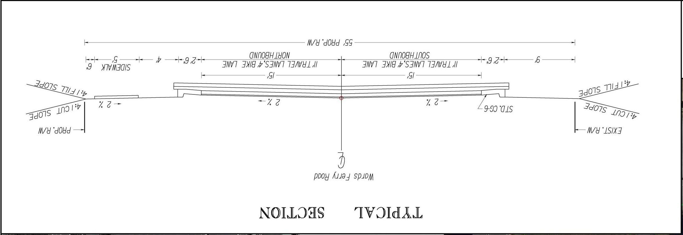
One corridor alternative developed included on-road bike lanes and a sidewalk on the east side of Wards Ferry Road. The bike lane/sidewalk typical section can be found in Figure 7: Bike Lane/Sidewalk Typical Section (Initial Alternative). The layout of this alternative along the entire corridor can be found in the Technical Appendix. This alternative provides for 11 foot wide travel lanes, 4 foot wide on-road bike lanes (one in each direction), curb and gutter drainage, 4 foot wide green space, and a 5 foot wide sidewalk.
Based on this geometric arrangement the typical section width is 55’, which means it is likely that ROW acquisition would be required. The curb and gutter drainage helps minimize the ROW needs, but it is a costly feature of a roadway. Specific ROW needs can only be determined through detailed engineering study based on survey. This alternative provides a narrow 11’ travel lane which will help limit speed with an on-road bike lane this will offer a small amount of room for driver correction before leaving the roadway. The curb and gutter not only minimizes ROW needs, it helps prevent vehicles from leaving the roadway which can be detrimental to motorist given the hazards adjacent to the road. A sidewalk on one side of the road helps minimize ROW needs while still providing a missing accommodation.
The second major corridor alternative developed was a 10 foot wide multi-use path on the east side of Wards Ferry Road. The multi-use path typical section can be found in Figure 8: Multi-Use Path Typical Section (Initial Alternative). The layout of this alternative along the entire corridor can be found in the Technical Appendix. This alternative provides for two 12 foot wide travel lanes, curb and gutter drainage, and an 8 foot wide multi-use path. Based on this geometric arrangement the estimated typical section width is 50.5 feet. Therefore there would be little to no ROW needed in this arrangement. A multi-use path offers accommodations for both bicyclist and pedestrians off the road, which is a safer environment for non-motorized users.
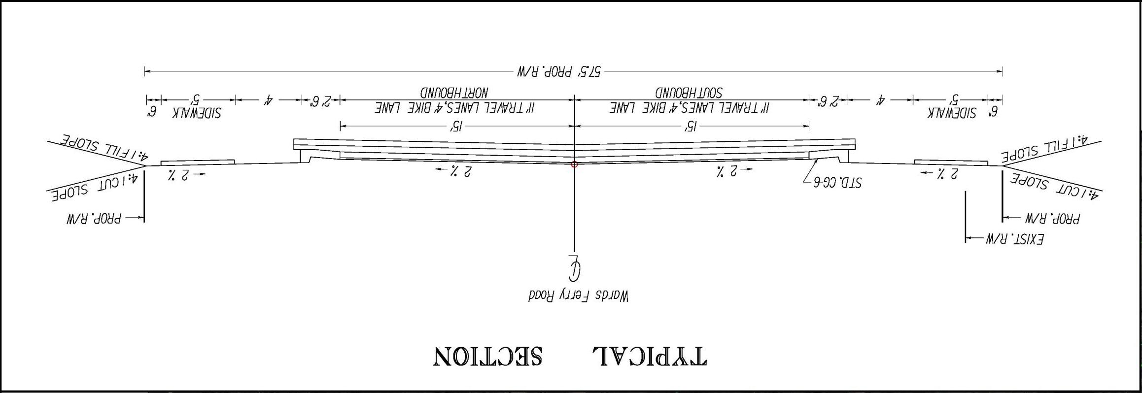
The two major corridor alternatives were considered by the Project Management Team and a hybrid alternative was developed and presented as the initial preferred alternative at the second citizen information meeting. The initial preferred alternative is shown in Figure 9: Bike Lane/Sidewalk Typical Section (Initial Preferred Alternative). The initial preferred alternative provided for 11 foot wide travel lanes, 4 foot wide on-road bike lanes (one in each direction), curb and gutter drainage, 4 foot wide green space, and 5 foot wide sidewalks on both sides of the road. This typical section was estimated to be 57.5 feet in width.
Study area intersections were evaluated in order to improve safety and increase capacity. There are 5 study area intersections, of which 2 - Timberlake Road and Wards Road - are
controlled with traffic signals and 3 – Adams Drive, Harvard Street, and Atlanta Avenue –are controlled with two-way STOP signs on the minor street approaches.
As previously stated in Section II.3 Safety, the existing conditions crash analysis did not indicate any major intersection concerns even though the corridor displayed higher than average crash rates. Crashes were spread fairly evenly throughout the corridor and no excessive clustering of crash frequencies at intersections was apparent.
Consequently, the development of intersection improvements focused on capacity and geometry, and each intersection was evaluated to determine what types of improvement would be appropriate. Typically, this involved evaluating whether or not turn lanes were appropriate by using VDOT Access Management Design Standards for Entrances and Intersections, and the evaluation was conducted using the forecasted year 2035 No Build Alternative volumes. Additionally, alternative intersection controls such as traffic signals and roundabouts were evaluted.
The intersection of Timberlake Road at Wards Ferry Road was not formally evaluated in this study because a more detailed engineering study is scheduled to follow the Wards Ferry Road Study in the Summer of 2013. The other study is named Logan’s Lane Interchange Modification Report. It will include detailed analysis of the signalized intersection of Timberlake Road and Wards Ferry Road including geometric design of preferred alternative that comes out of the study process. Because that study will be more detailed the Project Management Team felt the Wards Ferry Road Study should not provide recommendations that would likely be changed to different improvements in the span of a few months. Problems with the westbound left Timberlake Road turning movement frequently spilling into the through lanes were noted as a part of this study.
Adams drive is a two-way stop controlled intersection. On the east side of Wards Ferry Road it serves a small single family neighborhood and on the west side there is a driveway to Heritage High School. The intersecting side streets are off-set so that the centers of these roads are approximatly 50 feet apart. Through the planning process it was learned that Heritage High School is planned to be rebuilt on its current campus in the near future. The school will be designed to handle about 100 additional students more than the current school structure. Additionally, the driveway to the High School connects to the Heritage Elementary School which connects to Leesville Road. This connection between the two schools will be closed in the near future with a gate. It will normally stay closed except for certain events such as football games. Closing this connection may have some minor reduction in trips on the north end of Wards Ferry Road.
Adams Drive was evaluated for right and left turn lane warrants according to VDOT’s Access Mangemant Design Manual. Using forecasted No Build Alternative volumes the intersection meet warrants for a 100 foot northbound left turn lane with a 100 foot taper (See Figure 13). This intersection also meet warrants for a 100 foot right turn lane with a 100 foot taper. Traffic signal volume warrants were also evaluted using the 4 hour turning movements conducted as a part of this study. Using No Build Alternative volumes this intersection does not have high enough volume to warrant the installation of a traffic signal.
The Project Management Team recommends that due consideration is given to Heritage High School’s entrance on Wards Ferry Road when the new school is being designed. It is preferred that the entrance alignment can be corrected and that funding for the new school will include installation of the warranted turn lanes.

The intersection of Harvard Street at Wards Ferry Road is the most congested unsignalized intersection in the corridor. Currently motorist approaching this intersection on westbound Harvard Street experience moderate to severe delays when attempting to turn onto Wards Ferry Road. In the forecasted No Build conditions this intersection exhibits even worse delays and queues.
This intersection meets warrants for a northbound right turn lane with 100 feet of storage with a 100 foot taper. It also meets warrants for a 175 foot southbound left turn lane with a 100 foot taper.
Traffic signal volume warrants (4 hour warrant) are forecast to be meet for this intersection under No Build traffic volumes. It is likely that existing conditions volumes also meet the 4hour traffic signal volume warrants with p.m. peak period volumes. Traffic counts conducted for this study only included 2 hours in the p.m. peak period, and a warrant analysis could not be conducted. Further analysis is required to accurately determine whether traffic signal warrants are met. Four-way stop control guidance is met, according to the MUTCD, as a interim measure when a traffic signal is justified.
The operation of a traffic signal was analyzed using No Build traffic volumes with the following turn lanes added to the intersection: southbound left, northbound right, and a westbound left/through. The signalzied intersection was forecast to operate with an average vehicle delay of 7.7 seconds per vehicle in the a.m. peak hour and 11.5 seconds in the p.m. peak hour. Turn lanes would be very beneficial for the safety and operational characteristics of this intersection under signalized control. However, a traffic signal would not be effective as a traffic calming mechanism because motorists moving through the intersection on Wards Ferry Road would not need to slow down as they traverse the intersection under a green indication.
A roundabout was also considered as an improvement for the intersecton of Harvard Street at Wards Ferry Road. A single lane roundabout with single lane approaches was developed as an alternative (see Figure 9: Roundabout Concept – Wards Ferry Road at Harvard Street). The proposed roundabout design is a very simple design that will be easy for motorist to navigate. Other roundabouts are currently under construction in the City of Lynchburg. It should be noted that a roundabout has been previously considered as an improvement for this intersection.
Roundabouts offer significant improvements in safety especially when compared to signalized intersections. Roundabouts typically reduce injury and fataility crash rates, when compared to signalized intersections, because there are fewer conflict points, lower speeds, and fewer angle crashes. An added benefit of a roundabout on Harvard Street is the traffic
calming characteristic, since all motorists will need slow to approximately 10-15 mph to traverse the intersection.
Additionally, roundabouts can improve service levels (reduce delay) for minor street approaches when compared to either a traffic signal or STOP sign control. Roundabouts also typically reduce stops, fuel consumption, and pollution when compared to signalized intersections.

Originally a roundabout design was laid out directly over the existing intersection (as shown in Figure 9). This design that would require some right of way aquistion from two single family residences on the west side of Wards Ferry Road. Subsequently the roundabout design was shifted 50 feet to the east to minimize these impacts (See Figure 11). This will require shifting Wards Ferry Road on both approaches (as shown in the preferred alternative). The exact location of such an improvement would be decided during the design process.
Under forecast No Build volumes the proposed roundabout operates with adequate service levels (LOS C or better). The a.m. peak hour is forecast to operate with an average intersection delay of 9.0 seconds per vehicle and the p.m. peak hour is forecast to operate with an average intersection delay of 19.8 seconds per vehicle. Westbound Harvard Street delays would significantly decline with the addition of a roundabout. The forecasted levels
signalized intersection (with added turn lanes). Furthermore a roundabout would cost approximately the same amount as the installation of a traffic signal and turn lanes.
A comparative summary of forecast year 2035 service levels under the No Build Alternative (no improvements), under signalized control (with additional turn lanes) and under a roundabout are presented in Table 22.
Table 22 Summary of Harvard Street Alternatives Year 2035 Forecasted Volumes
*Theindividualmovement(i.e.westboundleftturn)withthemostdelayisshown fortheunsignalizedintersection. Averageintersectiondelayis not calculated for unsignalizedintersections.
The intersection of Atlanta Avenue at Wards Ferry Road is a two-way stop controlled intersection without turn lanes, and its volume is second only to Harvard Street among unsignalized intersections on the corridor. Turn lanes were evaluated, and under forecast No Build Alternative volumes warrants were determined to be met for a 125 foot southbound left turn lane and 100 foot taper.
A safety issue was identified by citizens at the first citizen information meeting (March 28, 2013) concerning sight distance on the eastbound Atlanta Avenue approach at Wards Ferry Road. A combination of a hill, fence, and shrubbery block motorists sight when looking to the north at southbound Wards Ferry Road traffic. Upon field inspection the problem was confirmed as severe, causing motorists on this approach to have to edge as close to the travel lane as possible to gain additional sight distance. This issue will likely require regrading the hill in order to provide the minimum sight distance requirements. Installing the warranted southbound left turn lane would provide an appropriate opportunity to correct the sight distance deficiency.
Many citizens requested installation of a traffic signal to improve safety and reduce Atlanta Avenue delays. No Build Alternative volumes were evaluated for meeting 4-hour signal volume warrants; however sufficient volumes to meet traffic signal warrants were not forecast.
Citizens also expressed concerns about the geometry of Atlanta Avenue. It is very narrow and has a steep vertical curve just east of Wards Ferry Road. A future study is needed to address the geomtric issues on Atlanta Avenue, and this has been included in the recommendations detailed later in this report.
The signalized intersection of Simons Run at Wards Ferry Road currently operates with excellent service levels and is forecast to continue to do so in the No Build conditions. The only recommendations that were developed for this intersection are pedestrian signals and crosswalks. Pedestrian accomodations are recommended because the intersection connects two major retail areas and it will also be a part of a future trail network that connects the retail areas along Wards Road.
The signalized intersection of Wards Road and Wards Ferry Road currently operates with adquate service levels and it is forecast to continue providing adequate service levels. However, during the analysis it was noted that the northbound Wards Road left turn movement exhibits queue lengths that will spill into the adjacent through lanes. There were two proposed improvements to address this issue: 1) lengthening the turn lane to accommodate the extended queues, or 2) adding a second left turn lane. A second left turn lane is geometrically feasible, and dual left turn lanes would reduce overall delays at the intersection. The Project Management Team chose not to recommend a preferred alternative for this intersection because dual left turn lanes may cause an increase in volumes on Wards Ferry Road. Extending the northbound left turn lane was also not recommended because it does not directly improve Wards Ferry Road.
The Project Management Team met and discussed the range of alternatives that were developed to address corridor and intersection deficiencies. Consideration was given to existing zoning, potential development (especially the potential expansion of Liberty University), available funding, right of way impacts, and value provided compared to cost. Discussions by the Project Management Team also focused on comments offered from both citizens and stakeholders. The first set of preferred alternative improvements (included in the Technical Appendix) presented at the second citizen information and
stakeholder meetings (May 9, 2013) included a typical section that would require right of way impacts to numerous parcels along the entire length of the corridor. Following the May 9, 2013 meetings the preferred alternatives were refined to reflect public comment related to concerns with right of way impacts. The final Preferred Alternative attempted to reduce or eliminate right of way acquisitions by eliminating the bike lanes component of the pavement section and providing a multi-use trail on the northbound side of the corridor right of way.
The preferred alternative for the multi-modal accommodations along the corridor underwent refinement through the study process. Neither of the two multi-modal alternatives was chosen. Instead, the Project Management Team recognized that a stand-alone multi-modal improvement must not take any significant right of way. It is not acceptable to have to acquire ROW from 50 or more land owners for a multi-modal improvement along this corridor. The preferred alternative was refined to specifically stay within the existing ROW. The final preferred alternative cross section provides for existing 11’ travel lanes, a 5’ wide ditch, and one 8’ wide multi-use path on the east side of Wards Ferry Road. During the design process the specific dimensions of the crosssection would be developed. There is still the possibility for isolated locations where ROW may be needed and there also may be locations that require curb and gutter drainage.
In developing the final preferred alternative cost became a prime concern to the Project Management Team. The elimination of several of the elements of the initial preferred alternative provided substantial cost savings. Removing curb and gutter drainage reduced the cost by and estimated 4.74 million dollars and eliminating the on-road bike lanes reduced the cost by an estimated 1.16 million dollars.
The recommended Preferred Alternative is shown for the corridor in Figures 10-13.
In the evaluation of existing environmental constraints and cultural resources there were very few impediments identified. There was one significant stream and flood plain crossing of Wards Ferry Road located about a half mile south of Adams Drive. There was only one church that fronted Wards Ferry Road – Lynchburg First Church of the Nazarene. There were no parks, schools, cemeteries, or environmental justice issues that are along the corridor that could be impacted by improvements to Wards Ferry Road. None of the preferred alternatives should have any significant environmental impacts.
Cost estimates were prepared for each proposed improvement developed as a part of alternatives development process using VDOT Transportation & Mobility Planning Division’s statewide planning level cost estimates. Cost estimates for the recommended
improvements have been developed in Year 2013 dollars. To estimate future year costs a yearly inflation rate of 3% has been recommended by VDOT’s Transportation and Mobility Planning Division, but since no funding year has been established for the improvements, adjustments for inflation have not been incorporated into the estimates. Preferred alternative intersection improvements are in bold text in Table 23. Proposed corridor improvements cost estimates are listed in Table 24. Costs associated with the preferred improvement alternative are shown in bold text.
As Table 24 shows, the cost of installation of the preferred alternative typical section - see Figure 8: Multi-Use Path Typical Section (Recommended Preferred Alternative) above – $1,903,500. It should be considered that actual costs will vary as more detailed drainage design is analyzed. The actual improvement may likely include sections where curb and gutter is required and acquisition of small parcels of right of way may be needed.
In coordination with the Project Management Team the Preferred Alternative was segmented and a prioritized implementation schedule was developed as follows:







































































































































































































The public involvement program conducted as part of the corridor study provided two direct opportunities for interested citizens and stakeholders to participate in the process with citizen information meetings and stakeholder meetings. Additionally, the public will have two more opportunities to express their opinion at Planning Commission and City Council public hearings.
The first Stakeholder Information Meeting was held on Thursday, March 28th, 2013 at 2:30 p.m. at the First Church of the Nazarene in Lynchburg, Virginia. The meeting invitations were sent via email or US Mail. The stakeholders that were invited to participate in the planning process included City of Lynchburg planners, City of Lynchburg transportation engineers, Lynchburg City School representatives, Liberty University representatives, Central Virginia Community College representatives, Region 2000 Local Government Council representatives, VDOT representatives, City Mayor’s office, City Council, Directors of Community Development, Public Works, Director of Streets, Economic Development Office, City Communications & Marketing, City Planning Commission, as well as a variety of business owners adjacent to the corridor. A total of 5 stakeholders signed the attendance sheet.
The materials presented at the first stakeholder meeting included maps showing environmental constraints, existing peak period traffic volumes, crash locations and frequencies, and year 2035 forecasted peak period traffic volumes and service levels. A brief PowerPoint presentation was provided by URS Corporation staff, in which the project purpose and schedule were detailed. After the presentation there were brief discussions concerning the project.
The first Citizen Information Meeting was held on Thursday, March 28th, 2013 between 6 p.m. and 7:30 p.m. at Heritage Elementary School in Lynchburg, Virginia. The meeting was also advertised in the newspaper and notices were posted on the City’s public access cable channel. In addition, notices by letter were sent to addresses that fronted Wards Ferry Road. Additionally, variable message boards were placed at each end of the corridor a week in advance of the meeting displaying meeting information. A total of 41 citizens signed the attendance sheet. By the appearance of the crowd there may have been another 10-20 people that attended the meeting.
The materials presented at the first meeting included maps showing environmental constraints, existing peak period traffic volumes, crash locations and frequencies, and year 2035 forecasted peak period traffic volumes and service levels. A brief PowerPoint presentation was provided by URS Corporation staff, in which the project purpose and schedule were detailed. After the presentation there was a question and answer period at the podium where City Staff, MPO staff, and consultant staff answered questions.
Twenty-two (22) written comments were submitted. Written public comments are summarized in Table 25. Most of the public was in support of improvements along the corridor. At the first citizen information meeting many citizens spoke of the safety issues such as the cross section of the road, speeding problems, and the need for additional intersection control. Additionally, many citizens also stated that it was impossible to bike or walk on the road because there are no accommodations and it wasn’t safe to attempt it on the road.
The second Stakeholder Information Meeting was held on Thursday, May 9th, 2013 at 2:30 p.m. at Church of the Lynchburg First Church of the Nazarene in Lynchburg, Virginia. The meeting invitations were sent via email or US Mail. A total of 4 stakeholders signed the attendance sheet. The materials presented at the second stakeholder meeting included maps showing alternatives considered along with the preferred alternative. A brief PowerPoint presentation was provided by URS Corporation staff, in which the project purpose and schedule were detailed. After the presentation there were brief discussions about the preferred alternative.
The second Citizen Information Meeting was held on Thursday, May 9th, 2013 between 6 p.m. and 7:30 p.m. at Heritage Elementary School in Lynchburg, Virginia. The meeting was also advertised in the newspaper and notices were posted on the City’s public access cable channel. In addition, notices by letter were sent to residential addresses for neighborhoods that use Wards Ferry Road as their primary source of access. This was a significant increase in mailings in comparison to the first set of mailings. Additionally, variable message boards were placed at each end of the corridor a week in advance of the meeting displaying meeting information. A total of 39 citizens signed the attendance sheet. By the appearance of the crowd there may have been another 10 or so people that attended the meeting.
The materials presented at the second meeting included maps showing environmental constraints, existing peak period traffic volumes, crash locations and frequencies, and year 2035 forecasted peak period traffic volumes and service levels. Additionally, there were maps showing the initial preferred alternative. A brief PowerPoint presentation was provided by URS Corporation staff, in which the preferred alternative was explained. After the presentation there was an open house style forum where individual questions were answered by a variety of staff at the maps displayed in the back of the room.
Seventeen (17) written comments were submitted. Written public comments are summarized in Table 25. Most of the public was in support of the preferred alternative improvements along the corridor.
Region 2000 Local Government Council engaged URS Corporation to conduct the Wards Ferry Road Corridor Study. The goal of the corridor study was to comprehensively plan for future transportation needs in order to effectively provide for the existing needs of the corridor as well as future needs of the corridor.
The existing Long-RangeTransportationVisionPlan (Year 2035) calls for a 3 or 4-lane cross section on Wards Ferry Road. These improvements are included in the Long-Range TransportationVisionPlan (Year 2035) as a part of the Vision Plan, which means that there is no funding identified for this project in the 20 year horizon. As such this study chose to focus on preserving capacity and improving safety while also providing facilities for all users of the roadway.
The corridor was reviewed for safety and capacity operational characteristics to determine any existing or forecasted deficiencies through the 2035 forecast period.
ExistingConditions
To determine existing conditions, AM and PM peak period traffic counts were conducted at six key intersections along the corridor. The three signalized intersections –Timberlake Road, Simons Run, and Wards Road are all operating with adequate service levels. Two of the three unsignalized intersections – Adams Drive and Harvard Street have existing deficiencies on the minor street approaches. The unsignalized intersection of Atlanta Avenue operates with adequate service levels.
Using records provided by Lynchburg, crash types and locations along Wards Ferry Road were also analyzed for the three year period from 2010-2012. Crash records show a total of 72 crashes during this period with 41 rear end crashes, 20 angle crashes, and 11 fixed-object off-road crashes. Out of the 72 total crashes in the study area there were 12 injuries and no fatalities. The crash rate for the corridor was significantly higher than the statewide average for similar facilities. However, the injury rate was below the statewide average crash rate for similar facilities. Crashes were generally evenly spread out through the corridor. The poor geometrics (lack of shoulders and turn lanes), access characteristics (frequent residential driveways and median crossovers), and moderate traffic congestion of the road are the most influential contributors to the high crash rates.
Using the data developed from a detailed scan of a wide range of environmental resources in the study area,
The overall finding of the evaluation of environmental resource constraints is that there does not appear to be known environmental resources that either individually or in concert with other resources that would preclude implementation of the improvements
in the Preferred Alternative. The design and permitting process of the individual improvements will require efforts to either avoid or minimize impacts to existing resources, but if reasonable efforts to achieve such avoidance and minimization are pursued, the need for permits can be either avoided or minimized.
The 2035 Lynchburg Regional MPO travel demand model was used to develop peak period forecast. Specifically, growth rates were computed by comparing the baseline (year 2000) model estimates with the year 2035 model forecasts, and the growth factors were then applied to the corridor and intersection peak hour traffic counts collected as part of this study.
Analysis of the No Build Alternative found that the volumes on Wards Ferry Road are forecast to grow from approximately 25% by the year 2035. With these higher volumes, capacity analysis determined that service will fall by approximately one letter grade from where they are in the existing conditions. Deficient conditions are forecast to occur at all of the three unsignalized intersections as through volumes on Wards Ferry Road make it extremely difficult for side street traffic to enter the traffic stream. All three of the signalized intersections are forecast to continue operating with adequate service levels.
Wards Ferry Road currently operates with moderate to severe congestion. As traffic volumes grow, motorist will experience even worse levels of service. This will be particularly acute when motorist attempt to turn onto Wards Ferry Road from a side street. Additionally, there is a higher than average crash rate on Wards Ferry Road. Finally, Wards Ferry Road does not offer accommodations for bicyclist or pedestrians even though existing land uses would support their use. Accordingly, the statement of purpose and need includes the following:
1. Frequencies of crashes along Wards Ferry Road have the potential to increase as traffic volumes and development pressures increase;
2. Service levels in the area of three intersections are forecast to deteriorate to inadequate levels unless improvements are developed and installed;
3. Capacity along the corridor should be preserved so that it can adequately serve traffic volumes forecasted to be generated by development as recommended in the Comprehensive Plan. Should residential densities exceed those recommended in the plan by 200-300 multi-family dwelling units the resulting volumes could not be adequately serviced by the existing two-lane roadway. Consequently widening the roadway to four lanes would be needed; and,
4. As a residential corridor frequented by school related traffic, pedestrian and bicycle accommodations are currently absent from the roadway facility.
A range of alternatives was developed to help address deficiencies identified in the corridor. These improvements included turn lanes, roundabouts, bicycle and pedestrian facilities, etc. The Project Management Team then considered the alternatives with respect to existing zoning, potential development (especially the expansion of Liberty University), available funding, right of way impacts, and value provided compared to cost. Discussions by the Project Management Team also focused on the response from public meetings. Based on previously stated criteria the Project Management Team selected the components of the preferred alternative.
Using VDOT planning level cost estimating data cost estimates were developed for all of the proposed improvements. The recommended turn lanes at Adams Drive are estimated to cost $203,000 for the southbound right turn lane and $480,000 for the northbound left turn lane. The proposed roundabout at Harvard Street is estimated to cost $850,000 (2013 dollars). The southbound left turn lane recommended at Atlanta Avenue is estimated to cost $495,000. Pedestrian accommodations at the Simons Run signalized intersection are estimated to cost $66,000.
The cost estimate for installation of the Recommended Preferred Alternative roadway typical section along the corridor is $1.9 million.
Year2035CapacityAnalysis
The proposed roundabout improvement at Harvard Street will greatly reduce Harvard Street approach delay and queue lengths. Turn lanes recommended at Adams Drive and Atlanta Avenue will offer minor improvements in delay while offering significant improvements in safety. The signalized intersections in the study area are forecast to operate with adequate service levels in the Year 2035. A separate engineering study and design for the Timberlake Road intersection with Wards Ferry Road is scheduled to begin in the summer of 2013 that study will develop recommendations for improvements to the capacity and safety of the intersection.
The scan of environmental resources within the study area identified only two areas of concern – a stream and flood plain located approximately ½ mile south of Adams Drive and a church fronting Wards Ferry Road – Lynchburg First Church of the Nazarene. These were the only major environmental recourses on the corridor. Neither of these two resources should have any significant impact on the preferred alternative.
There is no funding identified for improvements to Wards Ferry Road in the most current SYIP. Furthermore, there is no identified funding for improvement to Wards Ferry Road in the Year 2035 Region 2000 Long Range Transportation Plan.
For the improvements to Wards Ferry Road, construction funding may be allocated from urban construction funding, the MPO funds or from safety funds. The recommended improvements can be individually implemented when they achieve a sufficient level of priority relative to other needed improvements that the MPO in cooperation with the City of Lynchburg and VDOT program the funds in the appropriate SYIP fiscal year.
The public involvement program conducted as part of the corridor study provided two opportunities for interested citizens to participate in the process. In addition to the two citizen information meetings the public will have the opportunity to express their opinion at Planning Commission and City Council hearings. The Citizen Information Meetings were held on March 28, 2013 and May 9, 2013 at Heritage Elementary School in Lynchburg, Virginia. Forty-one (41) citizens signed the attendance sheet at the first meeting and thirtynine (39) signed the attendance sheet at the second meeting. Comments were received and incorporated into the study process. Citizens were in general agreement with the preferred alternatives.
Based on the findings of the analysis and the input from stakeholders, citizens and the Project Management Team, the following improvements are recommended for the Wards Ferry Road Corridor:
1. Install the Recommended Preferred Alternative typical section (as shown in Figure 8 and Figures 10-13) along the Wards Ferry Road corridor;
2. Install a roundabout at the intersection of Harvard Street and Wards Ferry Road;
3. At the intersection of Atlanta Avenue and Wards Ferry Road:
a. Install a southbound left turn lane to Atlanta Avenue; and,
b. Provide for adequate sight distance on the eastbound Atlanta Avenue approach to Wards Ferry Road (re-grade and relocate fencing).
4. At the intersection of Adams Drive and Wards Ferry Road in association with the renovation of Heritage High School:
a. Realign the school access to align with Adams Drive;
b. Install turn lanes
c. Atlanta Avenue merits a separate access management and multimodal (bike/pedestrian) study between Wards Ferry Road and the trail that is planned to end at the intersection of Atlanta Avenue and the driveway to Sam’s Club
5. Revise study forecasts if land use development policies in the corridor area are modified to accommodate an increase in dwelling units. It is likely that an increase in density will generate traffic volumes that would need a widened Wards Ferry Road to provide adequate service levels.