City Plan is Amarillo’s roadmap to the future. This comprehensive plan was carefully designed to reflect the community’s wants and will serve as a guide for the city’s growth and development, centered around a thoughtful land-use plan.
• Sets a Vision — Using community input, sets the course for Amarillo’s future.
• Enhances the Standard of Living — The plan’s primary purpose is to increase the quality of life in Amarillo while maintaining an affordable cost of living.
• Increases the Tax Base – By being more strategic in managing our growth, we can increase our tax base without increasing taxes for individuals.
• Shapes City Initiatives — City departments will leverage the plan as a guide, aligning infrastructure decisions and public investment with the community’s wants and needs.
• Allows for Change — As a flexible guide, it will adapt with the evolving needs of the community.
Why is City Plan important?
City Plan is important because we now have community direction for addressing future zoning decisions and changes to other development policies.
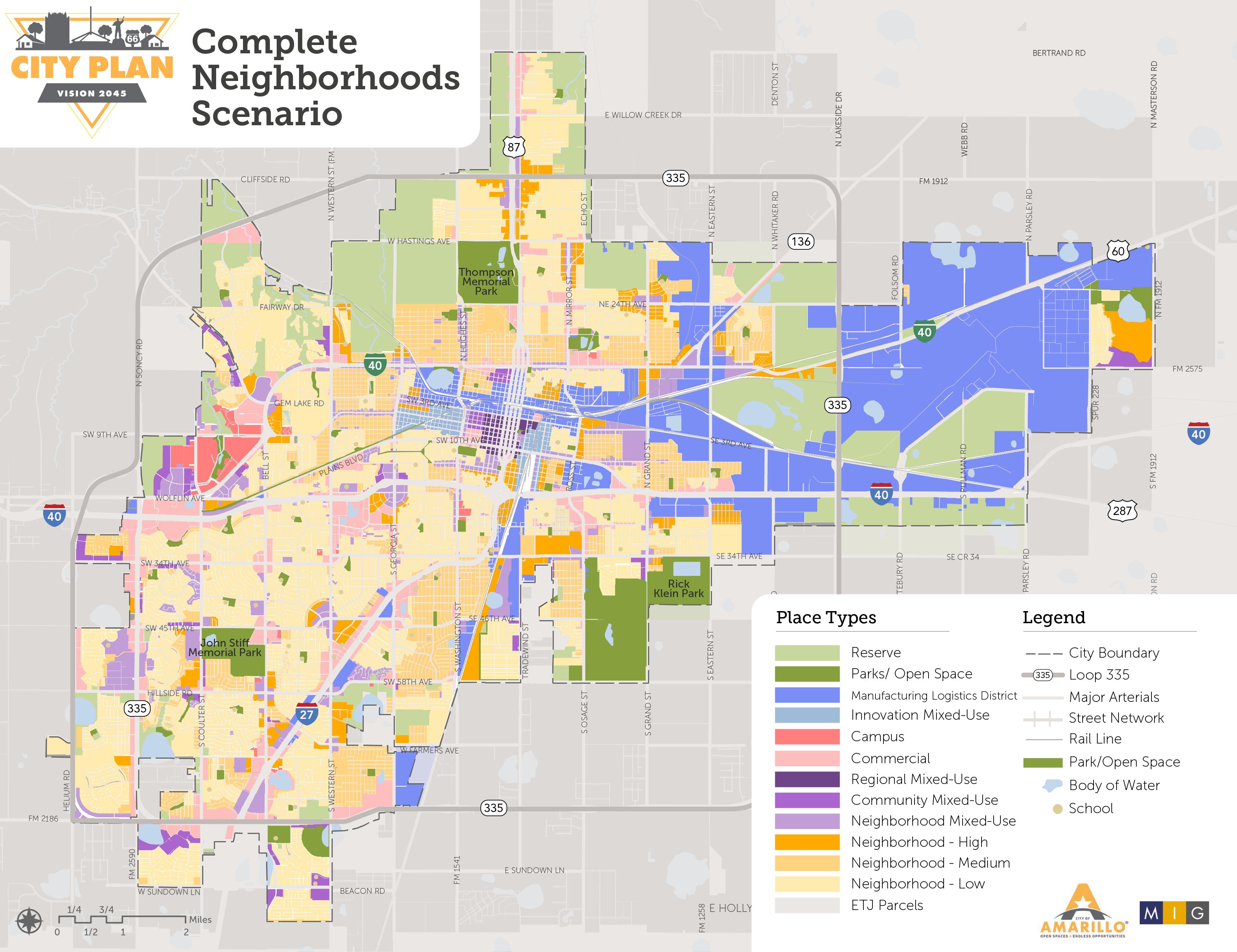
City Plan updates the City’s future land use map, based on a new vision and Complete Neighborhoods Scenario.
• Approximately 80% of the map preserves existing conditions
• Approximately 20% introduces flexibility and new opportunities through mixed-use districts and more housing variety.
The Complete Neighborhoods Scenario future land use map does not change or represent zoning. Rather, it serves as a guide for future zoning decisions.
Community Vision
In 2045, Amarillo is a diverse, vibrant and family-friendly community surrounded by wide-open spaces that has reinvested in its original infrastructure, neighborhoods and districts and guided growth on its edges that have created amenities and opportunities for all Amarilloans.
Amarillo is a regional economic and service hub and national destination that celebrates its small-town charm, historic and cultural roots and strategic location with a unique mix of shopping, employment, housing, entertainment, parks, and open space.
Guiding Principles
1
2
Create a variety of walkable destinations throughout the city while ensuring convenient local and cross-town connectivity for cars, bikes and transit.
Provide a range of housing opportunities with nearby employment and services to support all income levels and age groups.
Prioritize reinvestment in existing infrastructure, neighborhoods, districts, and recreational amenities. 3
Encourage a diversity of low- to mediumscale places throughout the city. 4
5
Increase overall quality of life for all residents by promoting safe, clean, and protected neighborhoods with well-amenitized park spaces, goods, and services nearby.
Celebrate cultural and historic assets along key corridors and in specific neighborhoods and districts.
What is the Complete Neighborhoods Scenario?
Area of Impact Neighborhood Unit Concept
Residential Growth
Commercial Growth
Focus is on lower-density housing types located within the interior of a square mile section.
Places larger commercial and institutional uses at the neighborhood edges and major intersections. Smallscale office uses provide a transition buffer from the the more intensive perimeter uses.
City Plan’s Complete Neighborhoods Scenario is a new land use policy for strategically accommodating growth. It replaces the Neighborhood Unit Concept by identifying a set of Place Types that are mapped across the City.
Complete Neighborhoods
Focus is on introducing diverse housing types, while preserving low-density housing. Higher density multifamily and residential mixed-use to be located along major corridors, near transit hubs, and near or within commercial centers.
Creates distinct mixed-use, commercial, campus, and industrial districts, as well as hubs for concentrated commercial and retail activity or creative arts and innovation. Introduces a variety of residential, retail, hospitality, and office mixeduse nodes that range from locally-serving to regionally serving. Medium-density residential, commercial, and mixed-use development to serve as a buffer from more intense uses.
Parks & Open Space
A neighborhood park and/or elementary school campus is at the center of a square mile section.
Community parks, public plazas, greenways, and trails will be integrated across districts and neighborhoods and multimodal connectivity will be prioritized.
How will City Plan affect Amarilloans?
Homeowners
Business Owners
City Plan aims to improve Amarillo through a collective and voluntary approach, maximizing opportunities and minimizing negative impacts. Different sectors of the community will experience varying outcomes.
• Most homeowners will not experience any change.
• In older neighborhoods, property owners may voluntarily change their zoning to protect single-family areas.
• All neighborhoods may see the introduction of new mixed-use development, more trails and amenities, and better connectivity.
• Most business owners will not experience any change.
• In certain areas, businesses who also own their property may voluntarily change their zoning to unlock new development opportunities such as mixed-use or missing middle housing types.
• Over time, infill and redevelopment will become easier through incentives and code changes.
Developers & Builders
• Developers and builders will start working from the updated Future Land Use Map immediately. Complete, connected, and mixed-use neighborhoods are encouraged.
• They may opt-in to zoning changes that will unlock new opportunities for mixed-use and different housing types.
• Infill and redevelopment will become easier through incentives and code changes.
Community
• No regulations are changed at the time of the plan’s adoption. Community members will participate in shaping the specific policy updates including revisions to development and zoning regulations as implementation progresses.
How was City Plan developed?
• 4,000 active community participants
• 6,841 unique page views on the City Plan website
• 3,369 survey responses
City Plan is the result of a collective community engagement effort!
• 54 out of 67 neighborhood areas completed map reviews
• 48 social posts with 226 shares, 617 comments, 9,831 clicks, and 176,262 impressions
What does success look like?
Success means Amarillo becomes a more vibrant, connected, and accessible community. Can you imagine it?
• More pedestrian-friendly intersections with easier connections from place to place
• Availability of a diverse range of housing options at all price points
• Removal of barriers to revitalization in older neighborhoods
• City coordinated infrastructure improvements — water, sewer, drainage, and streets — opening up Amarillo for new investment and development
• Complete, connected, and mixed-use neighborhoods, each with its unique character/charm
What comes next?
City Plan identifies five priorities and associated action items for implementation over the next five years.
Priority 1: Update Zoning Code and Development Policy Manual to align with City Plan Complete Neighborhoods Scenario.
• As an administrative update, adopt formatting from the 2022 draft Zoning Code revision without changes to development standards to establish a clear baseline from which to address future substantive amendments.
• As part of an annual Future Land Use Map review process, conduct a review with landowners and developers on their plans related to housing and major infrastructure needs.
• Work with the community on implementing Zoning Code revisions to enable more flexibility for Accessory Dwelling Units (ADUs).
• Work with the community on Zoning Code changes to allow for appropriate missing middle housing options in Neighborhood Place Types, including changes to setbacks and uses.
• Work with commercial developers to adjust site development standards where more intense uses exist next to residential areas, including parking, building heights, landscaping, screening and sidewalk connectivity.
• Modify the Subdivision Ordinance to expedite the approval process and add parkland dedication requirements.
• Update the City’s Airport Overlay Ordinance to clarify regulations required for development related to wildlife hazards, noise, and height.
• Develop template for an Agreement for Public Facilities that clarifies developer and CoA responsibilities for the provision and maintenance of developed parkland.
• Update the Zoning Code’s Schedule of Uses to incorporate mixed-use zoning districts.
Priority 2: Support and expand available tools to encourage reinvestment in older neighborhoods.
• Continue to support existing special funding districts (TIRZs, PIDs, NEZ) and explore opportunities for BIDs.
• Promote the revitalization of historic commercial corridors and “main streets” through the Neighborhood Stabilization Strategy.
• Advertise and expand existing façade improvement and home repair programs, particularly for historic preservation and neighborhood stabilization.
• Create a program to help restore and replace iconic signage (including large sculptural signage and neon signage) along Route 66.
• Create voluntary design guidelines and pattern books to encourage historically appropriate rehabilitation and new construction for historic commercial corridors
• Work with Community Development through the Consolidated Plan to understand affordable housing funds available and community needs.
• Conduct an external assessment of housing needs and policy, developing a coordinated action plan to create a more balanced affordable and attainable housing eco-system in Amarillo.
• Strategically develop updated incentive programs that deliver quality affordable and attainable housing through private sector partnerships.
What comes next?
City Plan identifies five priorities and associated action items for implementation over the next five years.
Priority 3: Create a comprehensive infrastructure improvement prioritization schedule and implementation strategy (or several, each addressing a specific type of infrastructure) to align funding allocation, such as CIP, TIP and annual budgets.
• Coordinate annually with Utilities and CIP on the Areas of Targeted Growth and Change.
• Complete a cost of service assessment for undeveloped land to inform infill policies.
• Prioritize infrastructure projects for federal grant funding that are consistent with Complete Neighborhoods Scenario.
• Align Level 2 plans with City Plan for water, wasterwater, streets and drainage.
Priority 4: Update existing Neighborhood Plans and establish a system for creating new Neighborhood Plan Areas.
• Continue to support and fund the Neighborhood Planning Initiative in partnership with Potter County.
• Establish baseline metrics to guide selection of future neighborhood plan areas and progress for existing plan areas.
• Align existing neighborhood plans with the Complete Neighborhoods Scenario and Neighborhood Stabilization Strategy.
• Incorporate infrastucture assessments into existing and future plans.
Priority 5: Improve the safety and quality of Amarillo’s pedestrian infrastructure, focusing on desired activity nodes including commercial and mixed use areas, parks and schools.
• Adopt Complete Streets, Vision Zero and Safe Streets and Roads for All policies.
• Complete pedestrian-friendly intersection improvements for ten priority locations.
• Develop a safety action plan with a list of prioritized capital projects.
• Adopt a thoroughfare plan that aligns with City Plan’s Complete Neighborhoods Scenario.
• Develop a sidewalk gap analysis for neighborhood plan areas and create an ongoing program to fund connectivity improvements.
• Modify street reconstruction standards to require increased pedestrian infrastructure and amenities along arterials.
• Develop options for citizen-driven traffic calming programs.