Mayor Cole Stanley, Mayor, City of Amarillo (Chairman)
Grayson Path, City Manager, City of Amarillo (ViceChairman)
Joe Price, City Manager, City of Canyon
Judge Nancy Tanner, Potter County
Judge Christy Dyer, Randall County
Tom Scherlen, Council Member, Amarillo City
Council H.R. Kelly, Commissioner, Potter County
Rusty Carnes, Commissioner, Randall County
Alex Guerrero, Local Government Services Director, Panhandle Regional Planning Commission
Blair Johnson, P.E., District Engineer, TxDOT Amarillo District
Kit Black, P.E., Director Transportation Program & Development, TxDOT Amarillo District
Non-Voting Members
Russel Washer, Urban Transportation Planner, TxDOT Amarillo District
Justin Morgan, Urban Planner, FHWA, Austin
Richard Neill, District Transit Planner, TxDOT, Amarillo District
Ex-Officio
John Smithee, State Representative, State of Texas
Four Price, State Representative, State of Texas
Kevin Sparks, State Senator, State of Texas
Ronny Jackson, U.S. Representative, State of Texas
MPOTECHNICAL ADVISORY COMMITTEE
Kyle Schniederjan, P.E., City Engineer, City of Amarillo
Chris Quigley, Transit Manager, Amarillo City Transit
Dan Reese, City of Canyon
Tim Sorrell, Randall County
Kit Black, P.E., Director Transportation Program & Development, TxDOT Amarillo District
Russel Washer, Urban Transportation Planner, TxDOT Amarillo District
Richard Neill, District Transit Planner, TxDOT, Amarillo District
Travis Muno, MPO Director, Amarillo MPO
Jenifer Ramirez, Senior Planner, Amarillo MPO
Devin Jones, Planning Technician, Amarillo MPO
Allison Knie, Planner II, Amarillo MPO
Julia Miller, Planner I, Amarillo City Transit MPO STAFF
Travis Muno, MPO Director, Amarillo MPO
Jenifer Ramirez, Senior Planner, Amarillo MPO
Devin Jones, Planning Technician, Amarillo MPO
Allison Knie, Planner II, Amarillo MPO
Julia Miller, Planner I, Amarillo City Transit
EXECUTIVE SUMMARY
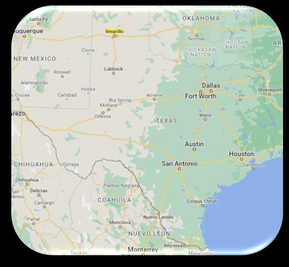
In the heart of the Texas Panhandle, the city of Amarillo stands at the crossroads of tradition and progress, where the winds of change carry the promise of a bright future. As the year 2050 emerges on the horizon, the Amarillo Metropolitan Planning Organization (MPO) embarks on a journey – a comprehensive Metropolitan Transportation Plan that not only anticipates the city's growth but also lays the groundwork for an interconnected, efficient, and sustainable urban transportation network.
The city's path toward 2050 combines factors that drive Amarillo into unparalleled expansion. A strategic blend of economic diversification, technological innovation, and cultural vibrancy has ignited a wave of transformation, attracting a population seeking opportunity, community, and a high quality of life. The Amarillo region has experienced steady growth and economic development, requiring an advanced transportation strategy. The arrival of anticipated population growth, industries, and cultural assets has set the stage for an urban landscape that demands transportation infrastructure capable of accommodating the demands of tomorrow.
The MTP plan outlines a comprehensive framework that enhances connectivity, promotes sustainability, and accommodates the evolving needs of the Amarillo metropolitan area. The 2050 MTP is focused on the principles of efficiency, accessibility, safety,andenvironmental stewardship byprioritizing several keyareas toaddresscurrent and future transportation.
The Amarillo Metropolitan Transportation Plan 2050 creates the guardrails to a dynamic transportation system, supporting the region's growth and enhancing accessibility in the Amarillo area. By fostering innovation, sustainability, and safety, the MTP paves the way for a resilient Amarillo metropolitan area that thrives well into the future.
Introduction
The Amarillo Metropolitan Planning Organization (MPO) recognizes the importance of a well-conceived transportation system in shaping the destiny of urban growth. The Metropolitan Transportation Plan (MTP) for 2050 is not merely a blueprint for roads, rails, transit, and freight; it is a display of Amarillo's ambitions – a tangible expression of its commitment to sustainable progress, accessibility, and inclusivity.
The purpose of the plan is to make certain that adequate transportation facilities are planned for the growth of the metropolitan area. Transportation decisions need to be made using a comprehensive planning process that includes the public and considers land use, development, safety, and security.
The plan looks at roadways, transit, bicycle, pedestrian, air, and rail facilities. It also addresses freight movement and congestion management strategies. Amarillo MPO, with stakeholders, urban planners, environmental experts, and the community at large, has produced a proposal that foresees the city's growth and its evolving transportation needs. This plan is rooted in data-driven insights, mindful of the importance of sustainability and a community poised to grow.
As we move toward 2050, the Amarillo Metropolitan Transportation Plan symbolizes a commitment to ensuring growth is not just static but a lived experience – one that is characterized by efficient movement, reduced congestion, and equitable access.
The MTP is a federally required document that has been prepared by the Amarillo Metropolitan Planning Organization in accordance with the requirements specified in the Fixing America’s Surface Transportation Act (FAST Act) of 2015. The plan is designed to be a flexible guide in directing the local transportation needs. As required by Federal Law, the MTP plan will be updated a minimum of every five years to ensure the goals and objectives of the plan are still applicable to the transportation needs of the study area.
Chapter 1 History of Amarillo MPO
Chapter 1 History of Amarillo MPO
History of Amarillo Transportation Planning
The history of transportation planning in Amarillo, Texas, is indicative of the city's growth and adaptation to changing times. What once began as a hub for cattle-drives and wagon trains has become a bustling urban center with a complex transportation network. The story of transportation planning in Amarillo is intertwined with the development of the Metropolitan Planning Organization (MPO).
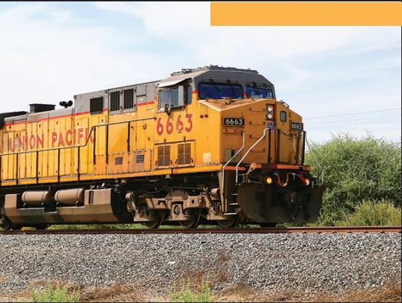
Before the establishment of modern transportation networks, Amarillo's history was rooted in its strategic location as a waypoint for cattle drives along the Chisholm Trail. As railroads extended across the nation, Amarillo became a vital junction, connecting east and west, north, and south. The arrival of the Southern Kansas Railway in 1887 transformed the city into a bustling railroad hub. Rail transportation facilitated the movement of goods and people that shaped the city's physical layout.
Automobiles triggered a revolution in transportation. The city's focus shifted from accommodating cattle drives to accommodating automobiles. The rise of the automobile fueled urbanization, spurring residential and commercial growth. As Amarillo expanded, the need for a more organized approach to transportation planning became evident.
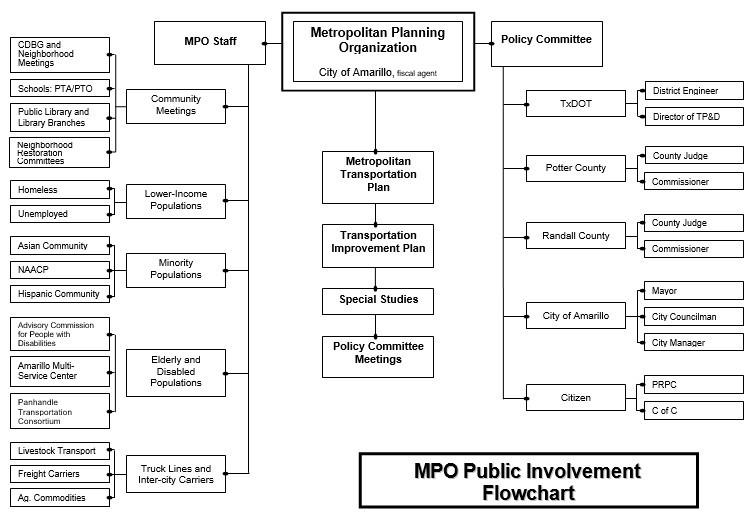
In response, the city established the Amarillo Metropolitan Planning Organization (MPO) in 1973, tasked with coordinating transportation planning efforts across the metropolitan area, involving local governments, transportation agencies, and the public. The Governor of the State of Texas designated the City of Amarillo as the fiscal agent for the Amarillo Metropolitan Planning Organization (MPO). Acting through its Transportation Policy Committee, the MPO, in cooperation with the Texas Department of Transportation (TxDOT), the Federal Highway
Wednesday, March 26, 2025 Amarillo Metropolitan Transportation Plan Page 9 of 189
Chapter 1 History of Amarillo MPO
Administration (FHWA), Federal Transit Administration (FTA), the Panhandle Regional Planning Commission (PRPC), Potter and Randall Counties, the City of Canyon and the City of Amarillo, administers the transportation planning process in the Amarillo urbanized area.
This designation was renewed by contract with TxDOT in September 2018. The contract reflects changes in the planning process brought about by the FAST Act and previous federal transportation legislation, such as ISTEA, TEA-21, SAFETEA-LU, and MAP-21. As population and economic activity surged, infrastructure demands, and traffic congestion increased. The MPO took on a critical role in developing solutions for transportation.
More recently, the MPO has embraced a multimodal approach to transportation planning, recognizing the need to accommodate various modes of travel, including public transit, biking, and walking. Projects like the development of bike lanes, pedestrian-friendly pathways, and improved public transit systems have aimed to create a more interconnected transportation network.
The Amarillo FY 2025–2050 Metropolitan Transportation Plan was developed in accordance with regulations set forth in the FAST Act, adopted December 4, 2015. The MPO is responsible, along with the State of Texas, for carrying out the provisions of the FAST Act under Section 1101; MAP–21 under Sections 1101 and 1105; SAFETEA-LU under Sections 1107 and 6001; ISTEA & TEA-21, under Title 23, United States Code, Section 134 (The Urban Transportation Planning Process), and further regulated by Title 23 Code of Federal Regulations 420 and 450.
The FAST Act does, however, build on MAP-21, which required Metropolitan Transportation Plans, to discuss potential environmental mitigation activities, to be developed in consultation with federal, state, and tribal, wildlife, land management, and regulatory agencies (resource agencies). Those activities include those aspects of 23 CFR 450.104, which states, in part:
• Serve to avoid, minimize, or compensate for impacts associated with implementation of the transportation plan.
• Consider neighborhoods, homes, businesses, cultural resources, parks, recreation areas, wetlands, water sources, forests, agriculture, etc.
• Regional scope may not necessarily address individual projects.
Amarillo MPO Planning Area
Transportation planning remains a constant effort. The city's commitment to enhancing mobility, reducing congestion, and promoting sustainability is confirmed through the MPO's continuous efforts. Technological advancements, such as smart traffic management systems and vehicle travel demand times, further shape the city's transportation systems. As the area grows and evolves, the MPO fosters innovation, collaboration, and visionary thinking in ongoing transportation planning activities.
Chapter 1 History of Amarillo MPO
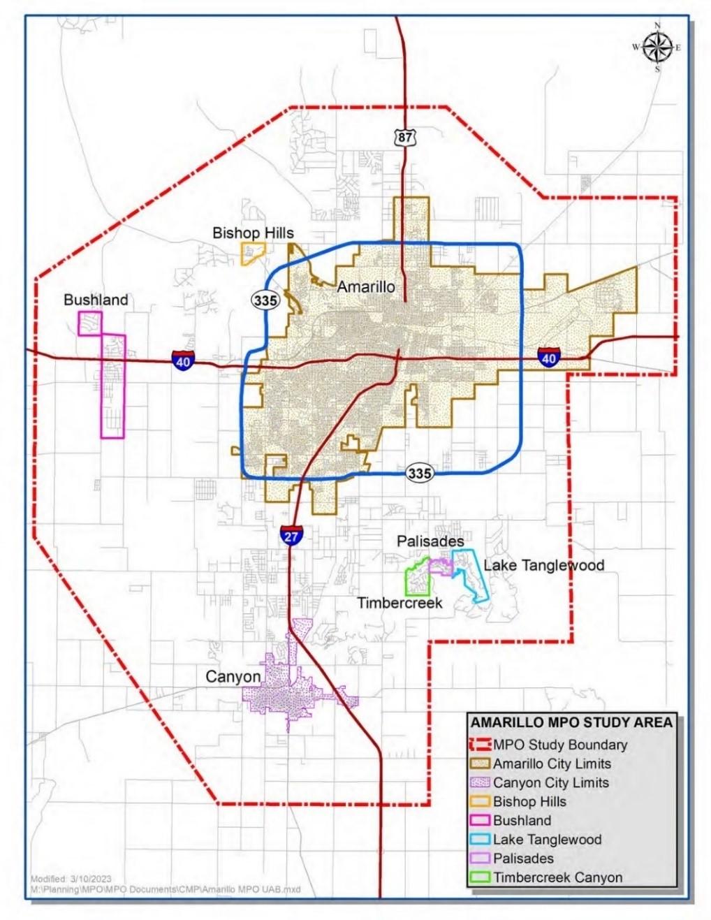
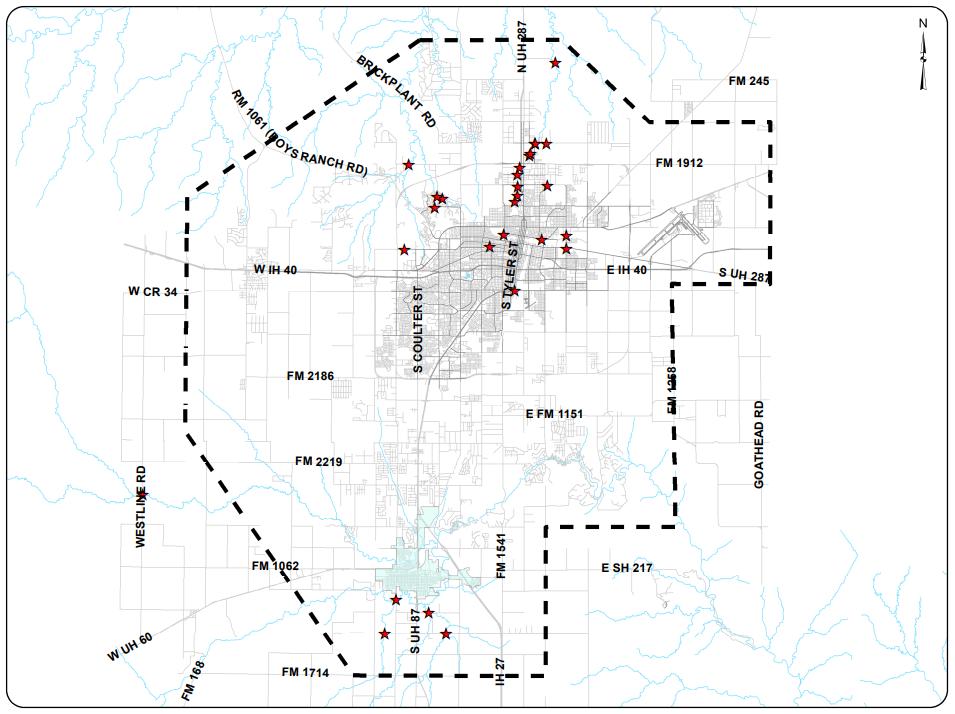
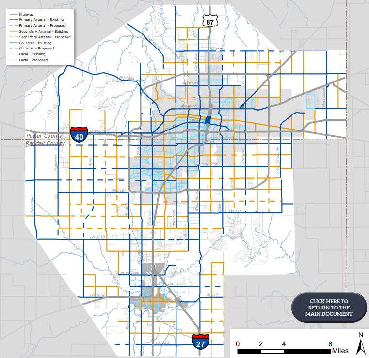
The Amarillo Metropolitan MPO Boundary Area comprises a region in the Texas Panhandle. Stretching across an expanse of approximately 594 square miles, the Amarillo MPO Boundary Area is characterized by its diverse blend of urban development, suburban communities, and rural landscapes. The boundary includes the City of Amarillo, the City of Canyon, the Village of Lake Tanglewood, the Village of Timbercreek Canyon, the Village of the Palisades and unincorporated portions of Potter and Randall Counties. The boundary encompasses neighborhoods, a patchwork of agricultural lands and industrial spaces, each with its own unique charm and character.
Transportation Management Area (TMA) Designation Planning for growth is crucial to ensure efficient and effective multimodal transportation. In June of 2023, the Amarillo MPO was designated a Transportation Management Area (TMA), triggered by the release of 2020 census information officially declaring that the population of the Amarillo urbanized area exceeded 200,000.
1 History of Amarillo MPO
Chapter
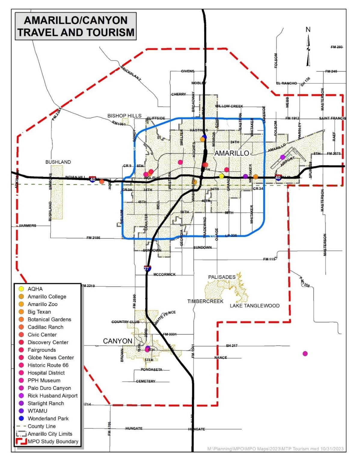
Exhibit 1 Amarillo MPO Boundary Map
Chapter 1 History of Amarillo MPO
By the year 2050, the Amarillo MPO boundary population is expected to increase to approximately 269,300. TMA designation has additional benefits such as:
1. Additional Category 7 Metropolitan Mobility and Rehabilitation future funding availability estimated $70 million to be allocated over a 10-year period.
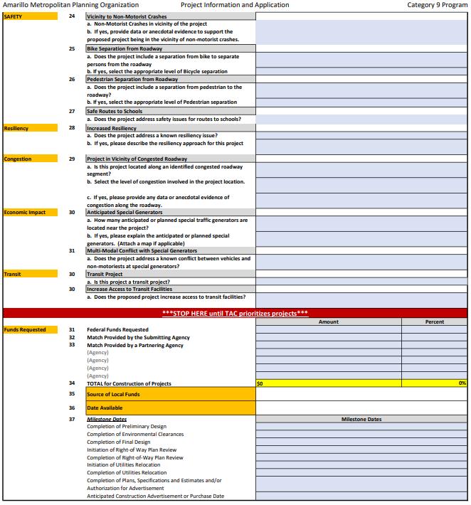
2. Additional Category 9 Transportation Alternatives future funding availability estimated $9 million to be allocated for a 10-year period.
The development of a comprehensive Metropolitan Transportation Plan is integral to the successful functioning of metropolitan areas. A well-structured long-range plan addresses transportation and accessibility issues. The Amarillo MPO, as a federally designated metropolitan planning organization, is obligated to align its transportation planning goals with federal requirements. These requirements often involve specific performance metrics, environmental considerations, and equitable distribution of resources. The Amarillo MPO serves as the means that these various layers of legislation come together, ultimately shaping the Metropolitan Transportation Plan.
Legislative factors combine the legal and regulatory structure in which transportation planning occurs. They serve as the guiding principles that influence safe and efficient management, operation, and development of surface transportation systems. These factors are derived from federal, state, and local laws, as well as regulations that encourage continued improvement of the metropolitan transportation planning process. The federal government's role in transportation planning is important, as it provides the necessary funding, guidelines, and oversight to ensure a dynamic transportation network.
In 1962, Congress passed the Federal-Aid Highway Act that addressed the need for transportation planning in urbanized areas. The Act established guidelines for projects to be eligible for federal funding. Projects needed to be included in the MPO's transportation plan to access federal aid. This requirement encouraged a more organized and coordinated approach to transportation investments.
The 1975 Joint Regulations on Urban Transportation Planning, between the Federal Highway Administration (FHWA) and the Urban Mass Transit Authority (UMTA), marked a significant development in the United States' approach to managing urban transportation systems. These regulations primarily focused on the collaboration between Metropolitan Planning Organizations (MPOs) and federal agencies to address the difficulties of urban transportation in metropolitan areas.
Chapter 1 History of Amarillo MPO
Key provisions of the 1975 Joint Regulations included:
1. The establishment of MPOs in areas with populations exceeding 50,000.
2. Collaborating among MPOs, state agencies, local governments, and federal authorities.
3. The UPWP to outline planning activities.
4. Development of a Transportation Improvement Program (TIP) outlining projects funded over a multi-year timeframe, also consistent with the MTP.
5. The importance of public involvement in the transportation planning process.
6. Significance of environmental considerations in transportation planning.
7. Compliance with the regulations to access federal transportation funding.
Federal legislation, such as the Fixing America's Surface Transportation Act (FAST), Moving Ahead for Progress in the 21st Century Act (MAP-21), and the recently enacted Infrastructure Investment and Jobs Act (IIJA), also known as the Bipartisan Infrastructure Law (BIL), outlines funding mechanisms and priorities that impact the MTP.
State transportation departments allocate funding, establish priorities, and contribute to the transportation vision. The Texas Department of Transportation (TxDOT) serves as a key partner to state MPOs, collaborating on projects and initiatives that enhance regional connectivity. Amarillo MPO's transportation planning aligns with TxDOT plans and incorporates state-specific goals into the MTP.
The 1975 Joint Regulations on Urban Transportation Planning shifted towards more comprehensive and collaborative approaches to transportation planning. By establishing guidelines for MPOs, emphasizing public participation, and linking federal funding to planning compliance, these regulations sought to address the obstacles of urban transportation.
Moving Ahead for Progress in the 21st Century Act, (MAP-21) is a comprehensive transportation legislation enacted in 2012 in the United States that significantly impacts Metropolitan Planning Organizations (MPOs) and their Metropolitan Transportation Plans (MTPs). MAP-21 carries on the eight (8) planning factors that were established under the former Safe, Accountable, Flexible, Efficient Transportation Equity Act: A Legacy for Users (SAFETEA-LU), originally enacted in 2005. MAP-21 brought about several significant updates for Metropolitan Planning Organizations (MPOs).
These updates included performance-based planning, freight, funding flexibility, consolidation of programs, and enhanced public involvement. The legislation aimed to improve transportation planning efficiency, accountability, and the alignment of federal resources with local needs and priorities. Accordingly, the Amarillo MPO considers projects and strategies that will address planning factors
Chapter 1 History of Amarillo MPO
The Fixing America’s Surface Transportation (FAST) Act of 2015, federal legislation that shaped transportation planning across the country. Key factors of the FAST Act that influence the Amarillo MTP include long term planning, multimodal transportation, stakeholder collaboration, funding flexibility, resiliency and safety, and technology advancements.
The Infrastructure Investment and Jobs Act (IIJA), also known as the Bipartisan Infrastructure Law (BIL), signed in November 2021, incorporates bridge and road repair, safety, and review of equity policies to address disparities in access to transportation services. The legislation included the Safe Streets and Roads for All program to reduce traffic fatalities. By integrating these factors, the plan lays the foundation for a comprehensive and ongoing transportation strategy that meets the unique needs of the Amarillo region.
Transportation Planning Process
Transportation planning is a multi-disciplinary process that involves developing and evaluating transportation plans and improvement programs. Transportation plans are created to provide for the anticipated needs of the community. To meet those needs the planning process must be flexible and continuously monitored to accommodate the changes that may occur in land use, economic conditions or other factors that may influence travel patterns.
The MPO studies different transportation investment strategies for roadways, public transit, cycling, and pedestrian facilities, as well as innovative technologies. MPOs carefully analyze different conditions using advanced modeling tools to assess its potential impacts on congestion reduction, air quality, accessibility, and economic development. This analysis helps decision-makers understand the trade-offs and benefits associated with different investment options.
Building on that analysis, the MPO engages in a prioritization process to identify the most effective and feasible transportation investments using factors such as cost-effectiveness, alignment with goals, and community support. Through a transparent process, a set of prioritized projects are identified to form a cohesive transportation strategy.
The criteria used to evaluate projects included in the TIP depend on the type of project and how far the project goes toward meeting the goals of the MPO. The items below include the major elements that are considered in selecting projects:
•Safety
•Preservation of the Capital Investment
•Congestion Relief
•Environmental Protection and Enhancement
•Economic Development
•Aesthetics
•Resiliency
Chapter 1 History of Amarillo MPO
With the prioritized investment plans in place, the MPO develops the Transportation Improvement Program (TIP), based on a four-year timetable, updated every two years. The TIP program of projects is financially constrained by several categories of funding sources. This document outlines the recommended transportation projects. Along with public engagement, the MPO Technical Advisory Committee (TAC) and the Policy Board Committee review and adopt the MTP. The TIP is located on the MPO website here MPO TIP Plan
Amarillo MPO is committed to diligent implementation and ongoing monitoring of the plan's progress. Collaboration with local, state, and federal partners is key to securing funding and resources for identified projects. As projects move from planning to construction, the MPO adapts the plan as needed to accommodate changing circumstances, emerging technologies, and shifting priorities.
Planning Required Documents, Programs, and Plans
The Metropolitan Planning Organization (MPO) is responsible for various plans alongside the Metropolitan Transportation Plan. While these plans are distinct in content and scope, they are designed to complement each other, ensuring coordinated progress.
The plans are required to identify short- and long-range strategies and actions for the implementation of the objectives. Current transportation demand and congestion management techniques must also be addressed. The plan is required to address different modes of transportation and must be financially constrained. A financial plan must be included to provide a reasonable estimation of funding sources for the life of the plan. Previous federal law, known as MAP-21 required 8 planning factors to be addressed in planning documents.
The formulation of the Amarillo MTP is guided by planning requirements and key factors, each playing a vital role in shaping the plan's direction. These elements ensure that the MTP remains an adaptable and inclusive document that serves the interests of the Amarillo metropolitan region. The MTP aligns with federal regulations, including those set forth by the U.S. Department of Transportation (USDOT) and the Federal Highway Administration (FHWA). These guidelines stipulate the need for a strategic, long-term perspective that considers safety, sustainability, congestion mitigation, and other critical factors.
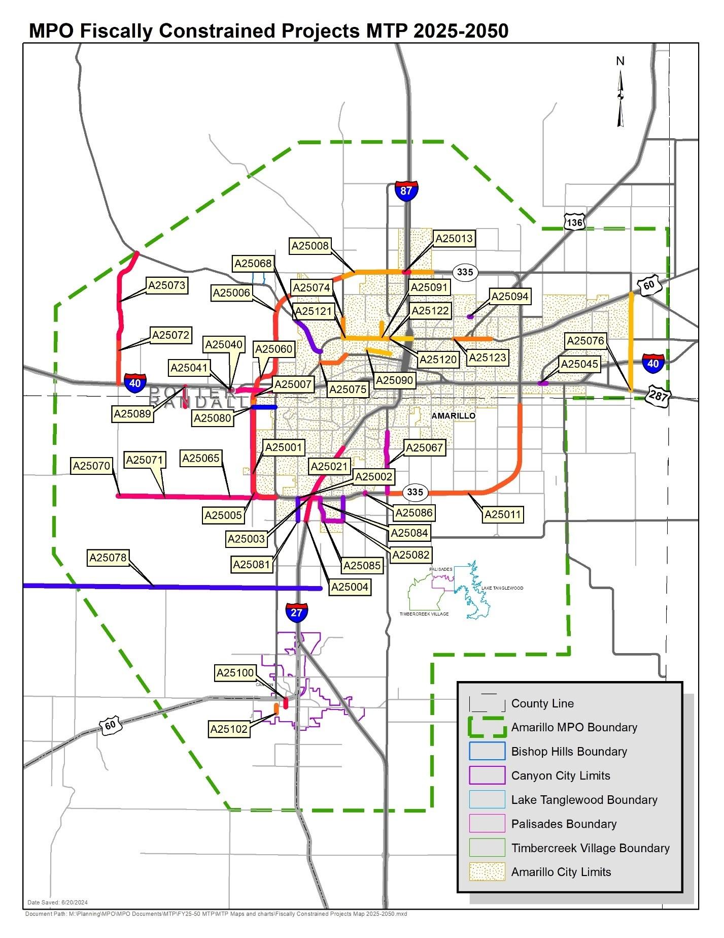
The existing transportation needs for both individuals and cargo within the Amarillo MPO Boundary Area involve several key initiatives. These include the enhancement of SL 335 to a fourlane divided road from SW 9th to Western, the expansion of IH-27 from four to six lanes, the construction of direct connector ramps, and the addition of a third-level main lane bridge at the intersection of IH-27 and SL 335. The list of approved projects for 2024, known as the Amarillo MPO Priority Projects, can be found in Exhibit 34. Additionally, plans involve extending SL 335 Westward to Helium Road to influence commuting patterns, particularly those headed to West
Chapter 1 History of Amarillo MPO
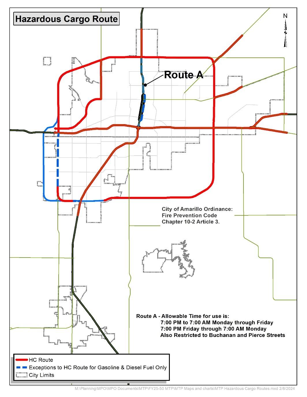
Plains High School, and rerouting heavy truck traffic along the loop instead of passing through downtown or Soncy Road.
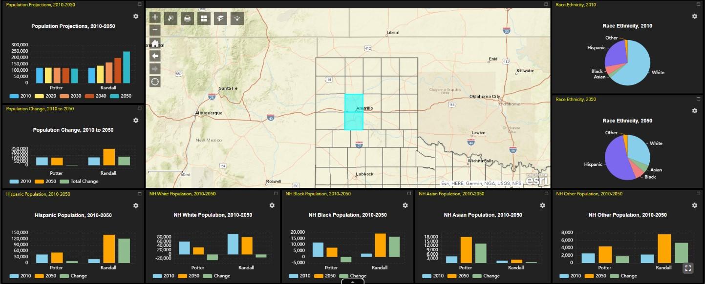
According to the One-Stop Demographic Data Dashboard for Counties, traffic trends in Potter and Randall Counties are expected to influence transportation demand. Potter County is expected to decrease by 6.28% in 2050. Randall County is projected to grow 81% from 138,104 in 2050. Population growth in Randall County will affect the economic growth projections and potentially shift commuting patterns, specifically along I-27 between Canyon and Amarillo and along SL335.
The key transportation planning elements include:
Long-Range Transportation Plan (LRTP), a fundamental element of state transportation planning. The LRTP provides a comprehensive outline for the region's transportation system over a 20-year period. It identifies the state’s multimodal transportation needs, sets goals and objectives, and establishes strategies to address those needs.
Metropolitan Transportation Plan (MTP), an important MPO document that typically spans a 25-year planning period, updated every 4-5 years, according to Title 23, U.S.C. Section 134 (i) (1). The MTP plan aligns with the LRTP and translates its broader goals into specific projects and programs. It prioritizes transportation investments, identifies funding sources, and outlines implementation strategies. The MTP is periodically updated to reflect changing regional priorities, emerging trends, and new transportation developments.
State Transportation Improvement Program (STIP), a state DOT document that spans a 4year period and is updated every 4 years and approved by the FHWA & FTA.
Transportation Improvement Program (TIP), a financially constrained program that lists transportation projects and initiatives scheduled for implementation within a 4-year timeframe, according to Title 23, U.S.C. Section 450.324. The TIP reflects the MTP and represents the MPO's commitment to delivering transportation investments in a timely manner. The TIP is developed collaboratively, involving input from local governments, transit agencies, and other stakeholders. Projects selected include elements of safety, financial stewardship, congestion relief, economic development, aesthetics, and resiliency.
The TIP includes a detailed listing of projects reasonably expected to begin within a fouryear period. Projects included in the TIP must also be included in the MTP and are chosen based on regional priority and available funding. Although the TIP covers a four-year period, it is updated every two years; therefore, an overlap between successive TIPs will occur.
Unified Planning Work Program (UPWP), MPOs are required to prepare the Unified Planning Work Program annual report. It is an annual or biennial statement of work prepared by
Chapter 1 History of Amarillo MPO
the Amarillo MPO every 1-2 years to identify the planning priorities and activities to be carried out within a metropolitan Amarillo MPO Boundary Area. The MPO lists work activities relevant to safety in the UPWP, including upcoming safety plans or studies, data collection efforts, corridor studies, and development of the MTP and TIP.
Congestion Management Process (CMP) is a systematic approach for managing congestion that provides accurate, current information on system performance and assesses alternative strategies for congestion management that meet state and local needs. The CMP is intended to move congestion strategies into the funding and implementation stages. In accordance with MAP-21 regulations, MPOs designated as TMAs are obliged to develop a CMP within 18 months of their TMA designation. Amarillo MPO is in the process of developing a CMP plan, to be completed in 2024. As outlined in Title 23, U.S.C. Section 450.320, the Amarillo Metropolitan Planning Organization (MPO) will employ the CMP to pinpoint congested corridors, assess potential remedies, and execute targeted projects aimed at enhancing traffic flow and reducing travel times. A congestion management process leads to the establishment of performance metrics and strategies for the system, which can be integrated into the MTP and the TIP. The CMP remains a dynamic and adaptable document, consequently, the CMP will undergo annual monitoring and receive updates as needed by changing circumstances.
Performance-Based Planning and Programming involves using quantitative measures to assess the effectiveness of transportation investments. The Amarillo MPO uses performance measures to track progress toward achieving transportation goals, such as reducing congestion, improving safety, and enhancing air quality. These measures guide decisionmaking and ensure that transportation investments align with desired outcomes.
Public Participation Plan (PPP), the PPP serves as the plan for including the community in the public involvement process for metropolitan transportation planning, engaging residents, businesses, and other stakeholders, to ensure that transportation plans reflect local needs and priorities. The MPO holds public meetings, workshops, and forums to gather input and incorporate diverse perspectives into the planning process. The PPP plan is located on the webpage MPO Public Participation Plan.
Environmental Considerations. The Amarillo MPO adheres to USDOT and FHWA requirements to assess potential environmental impacts associated with transportation projects. Safety Planning. The Amarillo MPO integrates safety considerations into all planning elements, aiming to reduce traffic accidents, injuries, and fatalities. The MPO seeks to change the current driving culture in the Planning Area to one that emphasizes safety, economy, and civility. Studies of collision data, roadway congestion, grade separation, traffic control devices, and driver inattention/behavior are among the underlying components necessary to understanding how to
Chapter 1 History of Amarillo MPO
better achieve a safe driving environment.
The MPO collaborates with local law enforcement, transportation agencies, and safety organizations to identify high-risk areas, implement safety enhancements, and raise public awareness about safe transportation. The Amarillo MPO's adherence to the transportation planning elements required by state and federal agencies is crucial for developing a wellfunctioning, sustainable, and efficient transportation system for the metropolitan area. Through
implementation of the Metropolitan Transportation Plan, and other essential elements, the Amarillo MPO ensures transportation investments align with regional goals, promote safety, and enhance the overall connectivity for the community.
Membership
The Policy Board Committee (PBC) is chaired by the Mayor of the City of Amarillo and comprised of the city managers of the Cities of Amarillo and Canyon, a City of Amarillo Council Member, a judge and County Commissioner from Potter and Randall Counties, the Executive Director of Panhandle Regional Planning Commission (PRPC), the TXDOT District Engineer, and Director of Transportation. The Committee meets quarterly on the third Thursday of January, April, July, and October, unless canceled for lack of agenda. Meetings normally begin at 1:30 p.m. and are held in Conference Room 275 on the second floor of Amarillo Simms Municipal Building, 808 S. Buchanan Street, Amarillo, Texas.
These meetings entail discussions and status reports on current transportation issues. If any voting PBC member is unable to attend a meeting, that member may appoint a voting proxy,
Chapter 1 History of Amarillo MPO
by writing the MPO in advance, which in turn shall be counted for quorum purposes. After these discussions, policy actions are taken that include adoption of the TIP and UPWP, revision of these documents or the Metropolitan Transportation Plan, and adoption of resolutions related to current transportation issues.
The PBC delegates technical review of the MPO’s work to the Technical Advisory Committee (TAC), a working group composed of professional staff members of the MPO’s organizations. The committee members review and approve technical and planning reports and brief PC members as required. Continuous technical support to the transportation planning program is provided by the MPO Staff and ad hoc committees composed of professional staff members of the MPO’s organizations. Technical studies are reviewed in detail to submit to the Policy Committee.
The MPO Staff is made up of professionals in planning and mobility. The Staff conducts studies and oversees projects as directed by PC. The Staff reports findings to the MPO Committees and participates in other community wide efforts. The combined work of the MPO Staff and the participating staff of other member organizations provides the information needed to make program and policy decisions.
Local Agencies & Plans
Local jurisdictions within the MPO Amarillo MPO Boundary Area create their own diverse plans for growth and development, such as comprehensive plans, zoning, capital improvements, building codes, subdivisions, thoroughfares, downtown, and parks. Local plans were consulted to gain the most accurate information about future development patterns.
To estimate projections for transportation projects in the MTP, we consulted local plans and staff for precise insights into future development patterns to develop current estimates and future year projections of various socioeconomic data to help plan for transportation projects and programs included in this MTP. The MPO staff consults with state and local agencies regarding land use, natural resources, and environmental protection. The City of Amarillo Planning Department develops and maintains the land-use map for the city. Environmental protection guidelines and restrictions are assessed by the Transit Department and by projects submitted through the MPO office.
Chapter 2 MTP Development
Transportation Planning Elements
Amarillo MPO developed a cooperative and comprehensive process to promote regional transportation planning. As a region with two distinct cities, the transportation users in the Amarillo MPO Boundary Area travel on a regional level. The proximity of businesses, schools, and other traffic generators to the major arterial roads and other modes of transportation define the characteristics and future needs of the region. The MTP plan outlines the state of current transportation, plans future needs and projects, to keep people and freight in the MPO region moving successfully.
Amarillo local stakeholder engagement and regional investments drive improvements in defining revenue constraints. Growing population forces MPO to review employment distributions throughout the city.
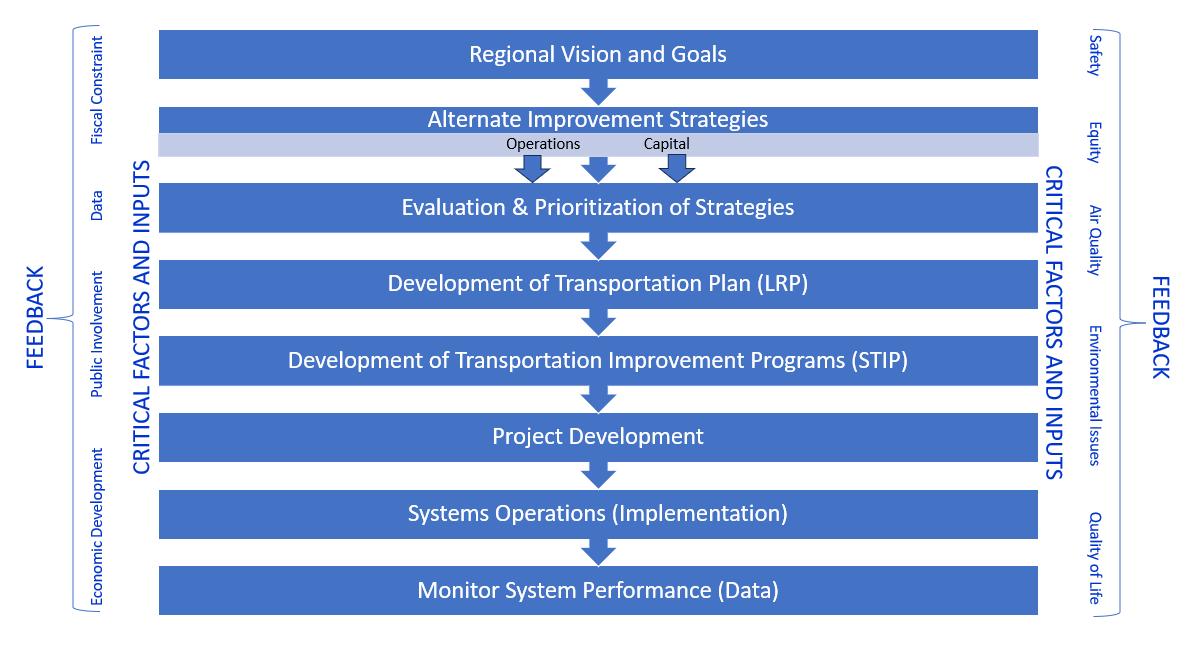
Exhibit 2 Critical Factors Feedback Loop
Long-Range Transportation Planning
Long-range transportation planning can be traced back to the enactment of the Federal Highway Transportation Act of 1962. This pivotal legislation mandated that urban areas with populations exceeding 50,000 must establish and sustain a comprehensive, collaborative, and continuing regional transportation plan. This plan includes the creation and upkeep of a longterm plan that articulates a vision for the transportation system.
The core principle of the highway program under MAP-21 centers around a shift towards a performance-driven approach. Both states and Metropolitan Planning Organizations (MPOs) are now tasked with allocating resources to projects that are designed to meet specific targets. These individual targets contribute towards the achievement of national objectives. The Amarillo Metropolitan Planning Organization has proactively integrated performance standards into its various project selection processes across different categories.
The FAST Act (23 CFR 450.306) requires MPOs to develop long-range transportation plans and Transportation Improvement Programs (TIPs) through a performance-driven, outcomebased approach to planning for metropolitan areas of the State. The metropolitan transportation planning process provides for consideration and implementation of projects, strategies, and services that will address the following factors:
• Support the economic vitality of the metropolitan area, especially by enabling global competitiveness, productivity, and efficiency.
• Increase the safety of the transportation system for motorized and nonmotorized users.
• Increase the security of the transportation system for motorized and nonmotorized users.
• Increase accessibility and mobility of people and freight.
• Protect and enhance the environment, promote energy conservation, and promote consistency between transportation improvements and State and local planned growth and economic development patterns.
• Enhance the integration and connectivity of the transportation system, across and between modes, for people and freight.
• Promote efficient system management and operation.
• Emphasize the preservation of the existing transportation system.
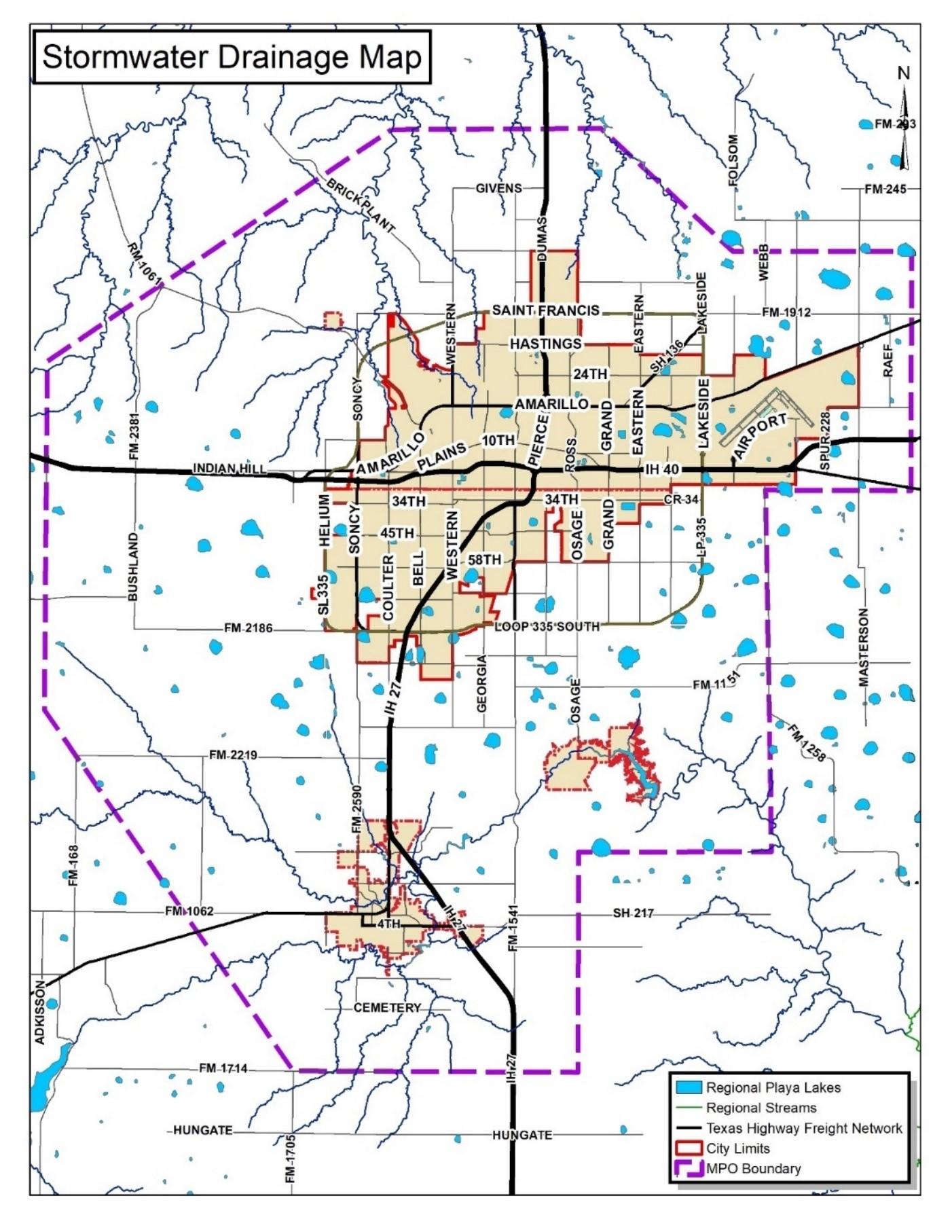
• Improve the resiliency and reliability of the transportation system and reduce or mitigate stormwater impacts of surface transportation; and
• Enhance travel and tourism.
In addition, the MPO supports national transportation goals, increasing the accountability and transparency of the Federal-aid highway program, and improving project decision-making through performance-based planning and programming. The MPO focuses on sustaining the national goals listed at 23 USC 150, including:
1. Safety: achieve a significant reduction in traffic fatalities and serious injuries on all public roads.
2. Infrastructure condition: maintain the highway infrastructure asset system in a state of good repair.
3. Congestion reduction: achieve a significant reduction in congestion on the National Highway System.
4. System reliability: improve the efficiency of the surface transportation system.
5. Freight movement and economic vitality: improve the national freight network, strengthen the ability of rural communities to access national and international trade markets, and support regional economic development.
6. Environmental sustainability: enhance the performance of the transportation system while protecting and enhancing the natural environment.
7. Reduced project delivery delays: reduce project costs, promote jobs and the economy, and accelerating project completion through eliminating delays in the project development and delivery process, including reducing regulatory burdens and improving agencies' work practices.
Federal & State Requirements
The FAST Act marked a milestone in transportation policy, built upon the MAP-21 legislation, and introduced several new provisions. One aspect of the FAST Act that continued was support for the Metropolitan Transportation Planning program. It requires metropolitan transportation plans and transportation improvement programs (TIPs) to incorporate infrastructure that improves upon an intermodal transportation system. The Act included provisions for pedestrian and bicycle facilities, promoting alternative modes of travel. Additionally, the FAST Act broadened this scope by including facilities vital for intercity transportation, such as buses, bus facilities, and commuter vanpool providers. The FAST Act required the identification of both public transportation facilities and intercity bus facilities as essential components (OLRC Office of the Law Revision Counsel, 2012) 23 U.S.C. 134(c)(2) & (i)(2)].
Notably, new planning factors included bolstering the resiliency and reliability of transportation systems, mitigating stormwater impacts, and enhancing travel and tourism experiences. A fundamental aspect of MAP-21 was the establishment of performance targets and measures at the national, state, and local levels. All established performance targets and measures were required to align with the state and national goals originally outlined in MAP-21 and continued by the FAST Act.
These objectives included a comprehensive approach, ranging from improving safety by reducing traffic fatalities and injuries on public roads to maintaining highway infrastructure assets in a state of good repair. The goals included reducing congestion on the National Highway System (NHS), enhancing the efficiency of the surface transportation system, improving the national freight network, and enhancing overall transportation system performance while preserving the environment. Furthermore, they aimed to reduce project costs and stimulate job growth.
Specific quantitative criteria published by the Secretary of Transportation established metrics to gauge progress towards these objectives. When state guidelines are made available, the Amarillo Metropolitan Planning Organization (MPO) adjusts its goals, objectives, and performance measures to align with the state performance targets. The MPO will embark on a public involvement process, seeking input from citizens, public agencies, transportation entities, private transportation providers, and other stakeholders. This public participation process is mandated by the FAST Act, ensuring that all relevant voices are heard in the transportation planning process.
Performance Targets
Under MAP-21 the States are required to set performance targets for transportation funds in the areas of safety, Transit Asset Management (TAM), Pavement and Bridge condition, and System performance measures. To comply with federal requirements, the MPO adopts yearly performance measure targets. A TIP that is amended after October 1, 2018, must meet the federal Performance Based Planning and Programming requirements to be approved.
Under the FAST Act, MPOs are given a choice to either set their own performance measures and respective targets or agree to support the statewide targets. Amarillo MPO chose to adopt TXDOT statewide performance targets to better utilize transportation investments in the region. In this approach, goals, measures, and data are used to inform policy makers about how to invest in a better performing regional transportation system.
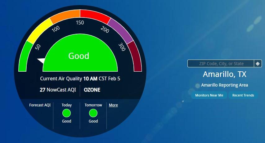
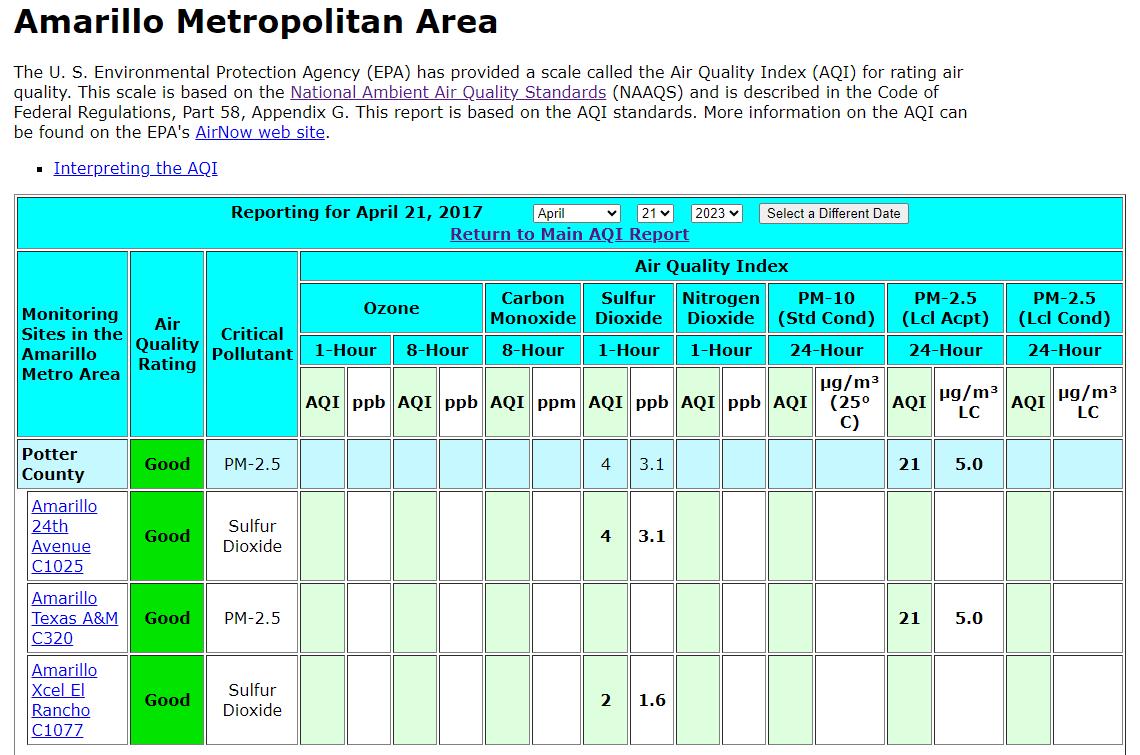
The Amarillo MPO also considers the following performance measures in addition to its scoring criteria. Specific performance targets in projects are weighted higher. MPOs serving as a TMA must submit a CMAQ Congestion Management Air Quality report if the area does not meet air quality standards, however, Amarillo MPO is in attainment for air quality and is not required to submit the report.
The MPOs shall establish targets for each of the performance measures for the respective target scope no later than 180 days after the State DOT establishes their targets. The MPOs establish targets and report progress toward achievement of targets to State DOT.
SAFETY PERFORMANCE
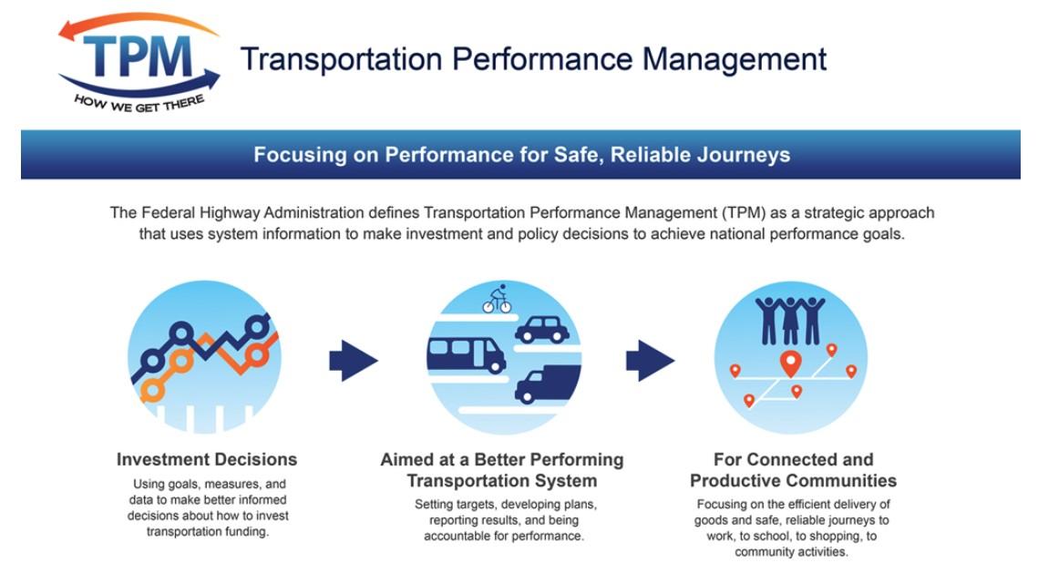
Safety Performance Management (Safety PM) is part of the overall Transportation Performance Management (TPM) program, which FHWA defines as a strategic approach that uses system information to make investment and policy decisions to achieve national performance goals. FHWA established highway safety performance measures to carry out the Highway Safety Improvement Program (HSIP).
These performance target areas will address topics including:
• Safety: PM1 (performance targets adopted by TxDOT and MPO) MPO’s newest targets adopted on January 18, 2024, Resolution No. 18-1-2024-1.
•Infrastructure Condition; PM2 (performance targets adopted by TxDOT and MPO) MPO targets adopted on July 20, 2023, Resolution No. 20-7-2023-1.
•System Reliability; PM3 (performance targets adopted by TxDOT and MPO) MPO adopted targets on July 20, 2023, Resolution No. 22-7-2023-2.
• Transit Asset Management Performance Targets (performance targets adopted by TxDOT and MPO) Targets adopted by MPO on January 18, 2024, Resolution No. 18-12024-2.
The MPO continues evaluating regional readiness for national transportation performance reporting, working collaboratively affects use the performance-based processes in project selection, and analyzing project effects to better meet performance targets.
Chapter 2 MTP Development
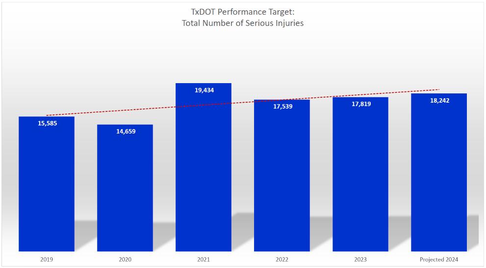
The Safety PM Final Rule establishes safety performance measure requirements for the purpose of assessing fatalities and serious injuries on all public roads. The Safety PM Final Rule establishes five performance measures as the five-year rolling averages to include: Number of Fatalities, Rate of Fatalities per 100 million Vehicle Miles Traveled (VMT), Number of Serious Injuries, and Rate of Serious Injuries per 100 million VMT.
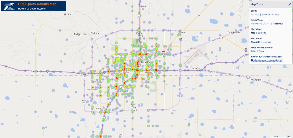
The Safety Performance Measure (PM1), found in 23 CFR 490.207, establishes safety performance measures to address fatalities and serious injuries on roadways and is evaluated using Fatality Analysis Reporting System (FARS), Crash Records Information System (CRIS), and Vehicular Miles Traveled (VMT) estimates and is to betterinvest transportation funding for safety improvement projects to support safe roadway networks.
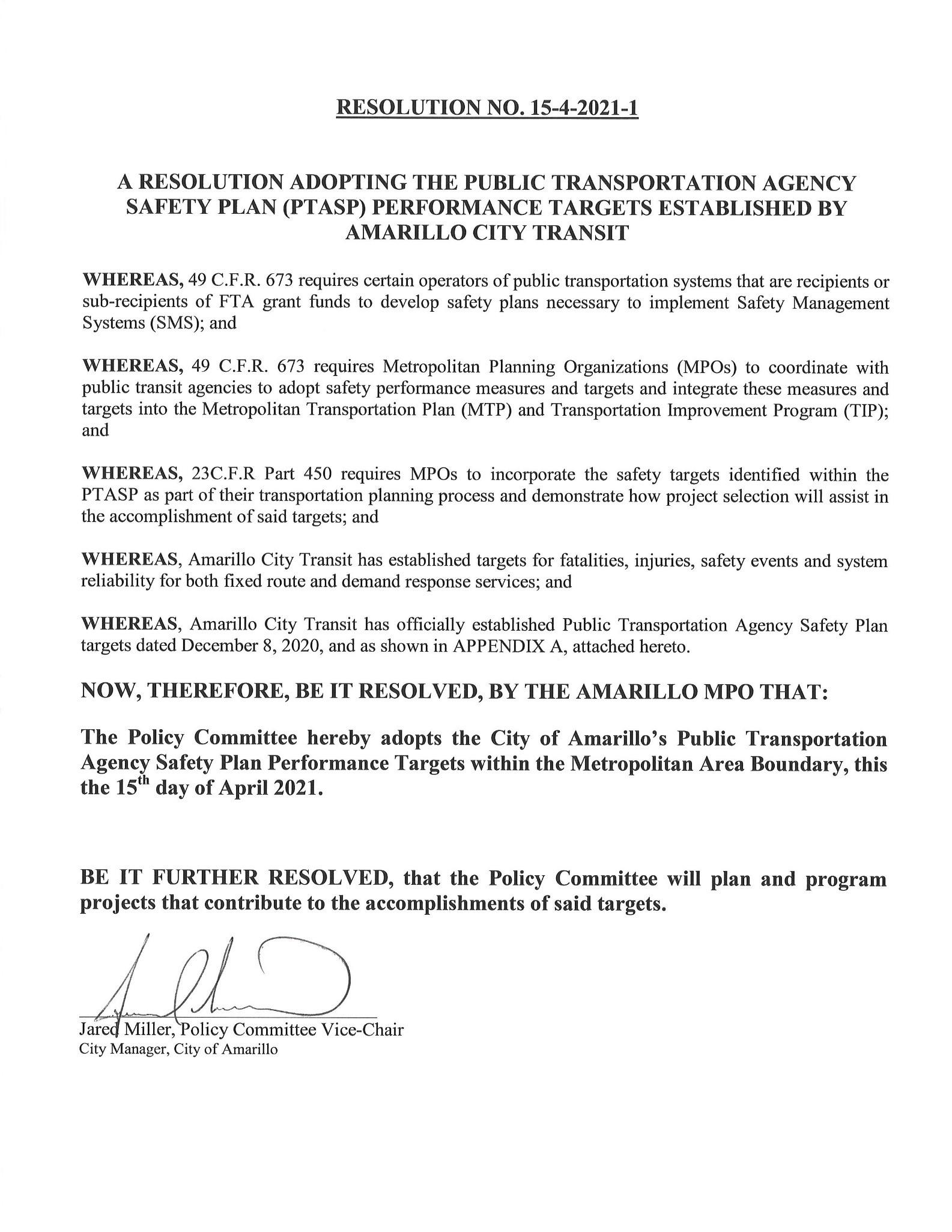
The Texas Department of Transportation (TxDOT) established their safety targets to support the Strategic Highway Safety Plan (SHSP) and the Highway Safety Improvement Program (HSIP). Once the State set their safety targets the MPO’s in Texas had 180 days to establish their targets. The MPO could either adopt the TxDOT targets or establish their own targets that would help achieve the statewide targets. The resolution is located at Exhibit 46 Public Transportation Agency Safety Plan (PTASP).
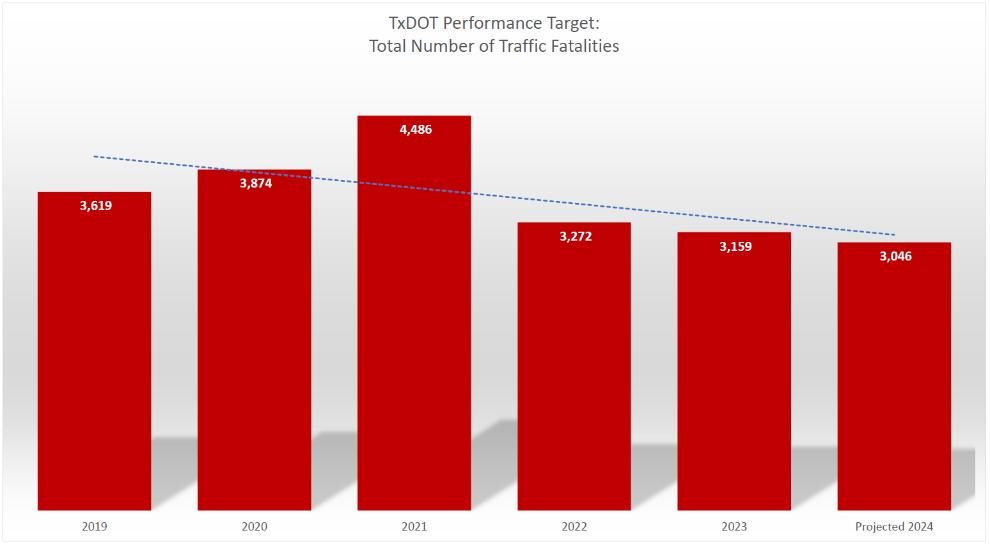
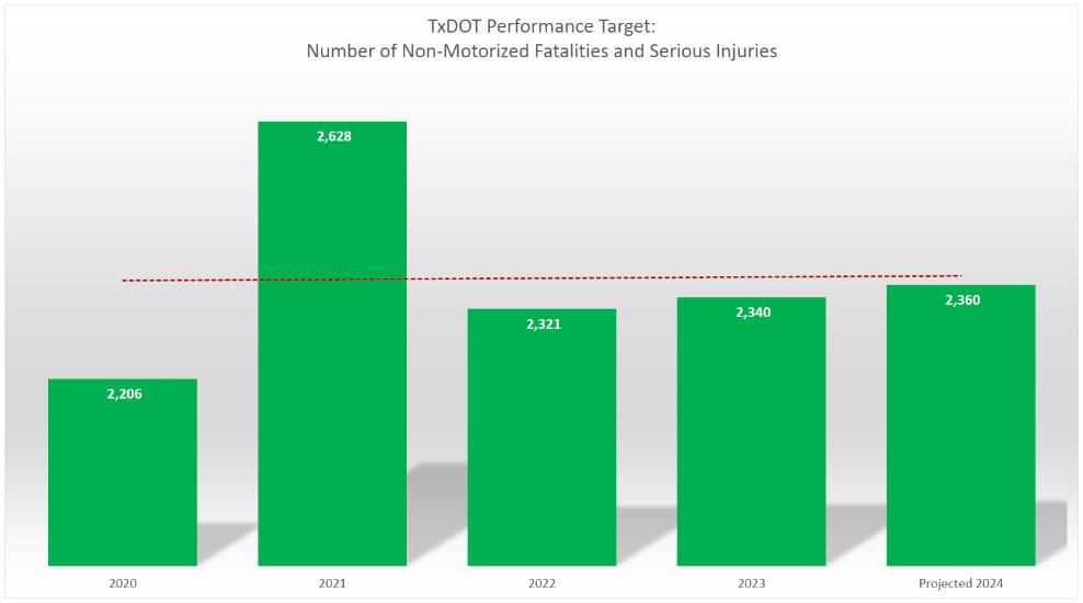
Safety performance measures (PM1) utilized a 5-year average of data to trend and project statistics for the state of Texas. The data shows an increasing trend for number of fatalities, rate of fatalities per 100 million vehicle miles traveled (VMT), number of serious injuries, and number of non-motorized fatalities and serious injuries; and a decreasing trend for rate of serious injuries per 100 million VMT. The state decided that a good achievable goal is to reduce the rates by 2%.
The Amarillo MPO recognizes the importance of setting goals and linking them to objectives and priorities to meet national, state, and local performance objectives and has adopted a resolution to support these state targets. Safety aspects of proposed projects are considered in the project prioritization process that the MPO utilizes to rank projects on a performance basis, which will help achieve safety target goals for the state. It is anticipated that all the individually listed projects in the original 2023-2026 TIP have an impact on safety and will aid in achieving the safety targets.
Chapter 2 MTP Development
By supporting the State’s safety targets, the MPO plans on doing the following:
1. Work with the state and safety stakeholders to address areas of concern for fatalities or serious injuries within the Amarillo MPO Boundary Area.
2. Coordinate with the state and include in the Metropolitan Transportation Plan (MTP) the safety measures and targets for all public roads in the metropolitan area.
3. Integrate into the planning process the safety goals, objectives, performance measures and targets.
Some recommendations may be incorporated to reduce the recurrence of crashes at hotspot locations, such as:
• Upgrades to existing transportation infrastructure.
• Modification or implementation of safety infrastructure.
• Creation of alternative routes to alleviate congestion.
• Public campaigns promote a particular safety issue.
• Requirement of the use of motorcycle and bicycle safety gear.
• An assessment of the transportation network to determine driver decisions.
Projects in the Metropolitan Transportation Plan (MTP) were developed through an evaluation involved in determining the number of fatalities and the rate of serious injuries at the project locations. A higher rate signified that a location exhibited more safety concerns than the statewide average, resulting in a more favorable score for safety-focused projects. Projects addressing hazardous road conditions may attain a higher ranking. In future projects, the Metropolitan Planning Organization (MPO) continues its commitment to evaluating project scoring criteria. The utilization of crash rates as a key metric remains important in the evaluation of transportation projects, reinforcing the state's objectives of a safe transportation system.
Chapter 2 MTP Development
PAVEMENT/BRIDGE CONDITION MEASURES (PM2)
TxDOT sets performance targets for federally required Pavement and Bridge Condition (PM2), performance measures, found in 23 CFR 490.307 that establishes performance measures to assess Interstate and Non-Interstate pavement and bridges as in good or poor condition and is evaluated using the State DOT Highway Performance Monitoring System (HPMS). Implementation of PM2 performance targets requires State DOTs to establish 2- and 4-year targets for non-Interstate pavement conditions and bridge deck area conditions, and only a 4year target for Interstate National Highway System pavement. .
To allow State DOTs to accrue and consider more complete data, there was no requirement for states to report 2-year targets on Interstate NHS infrastructure before the mid performance period progress report. Targets in this performance group are to be adopted every 4 years with the ability to make amendments to these targets in the 2-year mid-performance period progress report. Area MPOs were given the option of supporting the State’s adopted 4year targets or establishing their own; establishment of 2-year targets was not required of the MPOs. The Amarillo MPO has adopted a resolution to support the TxDOT established 4-year performance targets.
The performance measures are below:
1. The percentage of pavements of the Interstate System in “good condition.”
2. The percentage of pavements of the Interstate System in “poor condition.”
3. The percentage of pavements of the non-Interstate NHS in “good condition.”
4. The percentage of pavements of the non-Interstate NHS in “poor condition.”
5. The percentage of NHS bridges classified as “in good condition.”
6. The percentage of NHS bridges classified as “in poor condition.”
Chapter 2 MTP Development
Exhibit 4 Bridge Deck Condition PM2
Exhibit 5 Bridge Condition Map
Exhibit 6 Road Performance Measures
The MPO currently addresses performance measures by reviewing and potentially adjusting the criteria used to score projects in anticipation of the upcoming MTP reprioritization, which aligns with the State's objectives. As projects are completed and reliable data is gathered relating to performance measures, MPO staff assesses whether these measures have been met and whether any modifications are needed.
In Exhibit 4 Bridge Deck Condition PM2, the bridges listed in poor condition are all under construction or let for construction. Once completed, this should move the percentage of poor condition bridges to 0%, meeting the target for this adopted performance measure. The addition of new bridges and construction and maintenance of "fair" condition bridges will help to move them into the "good" category which should help increase the percentage of good condition bridges closer to its defined target.
System Performance/Freight/CMAQ Measures (PM3)
FHWA established air quality performance measures to assess vehicle emissions with a goal of reducing emissions resulting in better air quality. Metropolitan Planning Organizations (MPO) with a population over 1,000,000 that receive Congestion Mitigation Air Quality (CMAQ) funding are required to set targets for on-road mobile source emission reductions and to develop a CMAQ Performance Plan. Amarillo MPO has not reached the level of being required to submit a CMAQ.
Integrating System Performance Measures into the Transportation Planning Process
Amarillo MPO is integrating the System Performance targets (PM3) in the form of quantifiable strategies within the regional transportation planning process. The MPO incorporates performance measures into its programming activities through the core strategy, as related to system management and operations. The project evaluation system was intended to be performance-based for prioritizing projects for the region. On July 20, 2023, the PBC approved the adoption of the State’s performance measure targets regarding System Performance.
Exhibit 7 System Performance Measures
Two of the three targets for System reliability performance measures (PM3) are measured by percentages of interstate and non-interstate that meet a Level of Travel Time Reliability Ratio (LOTTR) of below 1.50 for different time segments of the day. (Monday-Friday time segments: 6am-10am, 10am-4pm, 4pm-8pm; Weekend time segment: 6am-8pm)
This ration is calculated with the following equation: LongerTravelTime(80th)=#seconds=LevelofTravelTimeReliability NormalTravelTime(50th)seconds
With: Longer Travel Time (80th) being the 80th percentile of travel times along a defined road segment Normal Travel Time (50th) being the 50th percentile of the travel times along the same road segment.
Chapter 2 MTP Development
The road segment is considered reliable if the ratio is below 1.50. The percentage of reliability on the Interstate Highway System for the Amarillo MPO was calculated to be 100% and on the Non-Interstate National Highway System to be 94.8% for year 2018 based on data from the National Performance Management Research Data Set (NPMRDS).
The Truck Travel Time Reliability (TTTR) performance target of PM3 is measured as an index which is calculated using the following equation:
���� being the length of segment x in miles
���� being the reliability ratio metric of the 95th percentile to the 50th percentile The adopted TTTR index target for the year 2024 for TxDOT and Amarillo MPO is 1.28. For baseline year 2019, the TTTR index was calculated to be 1.22 for the Amarillo MPO area using data from NPMRDS. The Amarillo MPO exceeds the adopted PM3 targets for system reliability and will continue to prioritize projects to maintain its high level of reliability.
Project Matrix for Benefits to Performance Measure
Project Matrix for Benefits to Performance Measure
Project Matrix for Benefits to Performance Measure
A250T01S
A250T02S
A250T03S
A250T04S
A250T05S
A250T06S
A250T07S
A250T08S
A250T09S TRANSIT ASSET MANAGEMENT/STATE OF GOOD R
EPAIR PERFORMANCE MEASURES
Transit Asset Management (TAM) is a business model that uses the condition of assets to prioritize funding. The MAP-21 Final Rule 49 USC 625 established strategic and systematic processes of operating, maintaining, and improving public capital assets effectively through their entire life cycle. This rule includes the definition of “Transit Asset Management Plan” (TAM) as the strategic and systematic practice of procuring, operating, inspecting, maintaining, rehabilitating, and replacing transit capital assets to manage their performance, risks, and costs over their life cycles, for the purpose of providing safe, cost-effective, and reliable public transportation. The capital asset is in a state of good repair if it can perform its designed function, the current condition does not pose an identified unacceptable safety risk, and the life-cycle investment needs of the asset have been met or recovered.
Performance measures for equipment (non-revenue), support service, and maintenance vehicles is the percentage of vehicles that have either met or exceeded their useful life (ULB) Rolling stock performance measures are the percentage of revenue vehicles within a particular asset class that have either met or exceeded their ULB. The performance measures for rail fixedguideway, track, signals, and systems are the percentage of track segments with performance restrictions. Facilities performance measures are the percentage of facilities within an asset class, rated below condition 3 on the “TERM” scale. A provider must set performance targets for each applicable performance measure, based on realistic expectations, using the most recent data available, and financial resources from all sources available within the plan horizon period.
Ensuring optimal performance in transportation facilities requires the implementation of effective management and operational strategies. Key components of this approach include the proper maintenance of facilities and the utilization of Intelligent Transportation Systems (ITS). ITS integrates advanced information and communication technologies into various transportation elements, empowering users with enhanced information for safer, more coordinated, and intelligent use of transportation networks. Given the cross-jurisdictional nature of transportation facilities, collaborative efforts among entities become crucial to establish a safe and efficient transportation network for the movement of people and goods. This collaborative framework is explored further in subsequent sections, addressing management and operational policies at different jurisdictional levels.
The Metropolitan Planning Organization (MPO) engages in regular discussions with Amarillo City Transit (ACT) to formulate strategies for the operations and maintenance of the present and future public transportation system within the Amarillo urban boundary. ACT seamlessly incorporates Operations and Maintenance (O&M) costs as an integral part of the transit system's operations, opting not to break down expenses for vehicle maintenance or facility repairs. O&M needs for fixed route and para-transit systems are detailed in tables, indicating year of expenditure (YOE) total project costs. These costs are projected with a four percent annual average inflation rate, aligning with recommendations from the Federal Transit Administration (FTA) and Texas Department of Transportation Public Transportation Division (TxDOT PTN).
Quantifying the diverse and intricate systems employed to uphold the efficiency of the MPO area transportation system poses a challenge. Each jurisdiction and agency adopt unique accounting methods for these activities, often driven by distinct goals and priorities. As the jurisdictions contributing to the MPO process share information on their existing system's operations and maintenance costs, the MPO will transparently report these activities in the Metropolitan Transportation Plan (MTP) and other documents. This approach aims to provide the public with a clearer understanding of the concerted efforts undertaken in managing and maintaining the transportation infrastructure.
A target is a goal associated with performance that is used to track the progress of capital assets towards achieving a state of good repair. Targets connect a provider’s strategic goals to the actions that the provider will take to reach those goals. The TAM Final Rule defines a performance target as a quantifiable level of performance or condition, expressed as a value for the measure, to be achieved within a period required by FTA.
Transit providers that receive federal funds and either own, operate or manage capital assets used in providing public transportation are required to develop and implement TAM Plans and submit performance measures, annual condition assessments, and targets to the National Transit Database. Transit Asset Management Plans contain the capital asset inventories for rolling stock, equipment, non-revenue vehicles, facilities, and rail infrastructure.
The Federal Transit Administration (FTA) continues to advance efforts to implement a performance-based approach to planning and established requirements for the Transit Asset Management plan (TAM) to guide the safety enhancements, reduction of maintenance costs, increasing reliability, and improving performance.
A transit system is in a state of good repair when it possesses and maintains a comprehensive list of sufficient capital assets and rolling stock to operate at a full level of performance. Furthermore, it is imperative that an agency’s management procedures work into the asset management plan. The TAM ensures the majority of an agency's assets remain within the anticipated useful lifespan, and that the remaining assets continue to operate as originally intended. Currently, the FAST Act requires State DOTs and MPOs to establish performance targets and report on the progress toward achieving these targets for the following performance measures:
• The Transit Asset Condition Performance Rule, found in 49 CFR 625.43, establishes performance measures to assess the condition of regional transit networks as defined as State of Good Repair (SGR) and documented in a transit agency’s Transit Asset Management (TAM). SGR targets measure system performance and evaluate how well a transit system is performing.
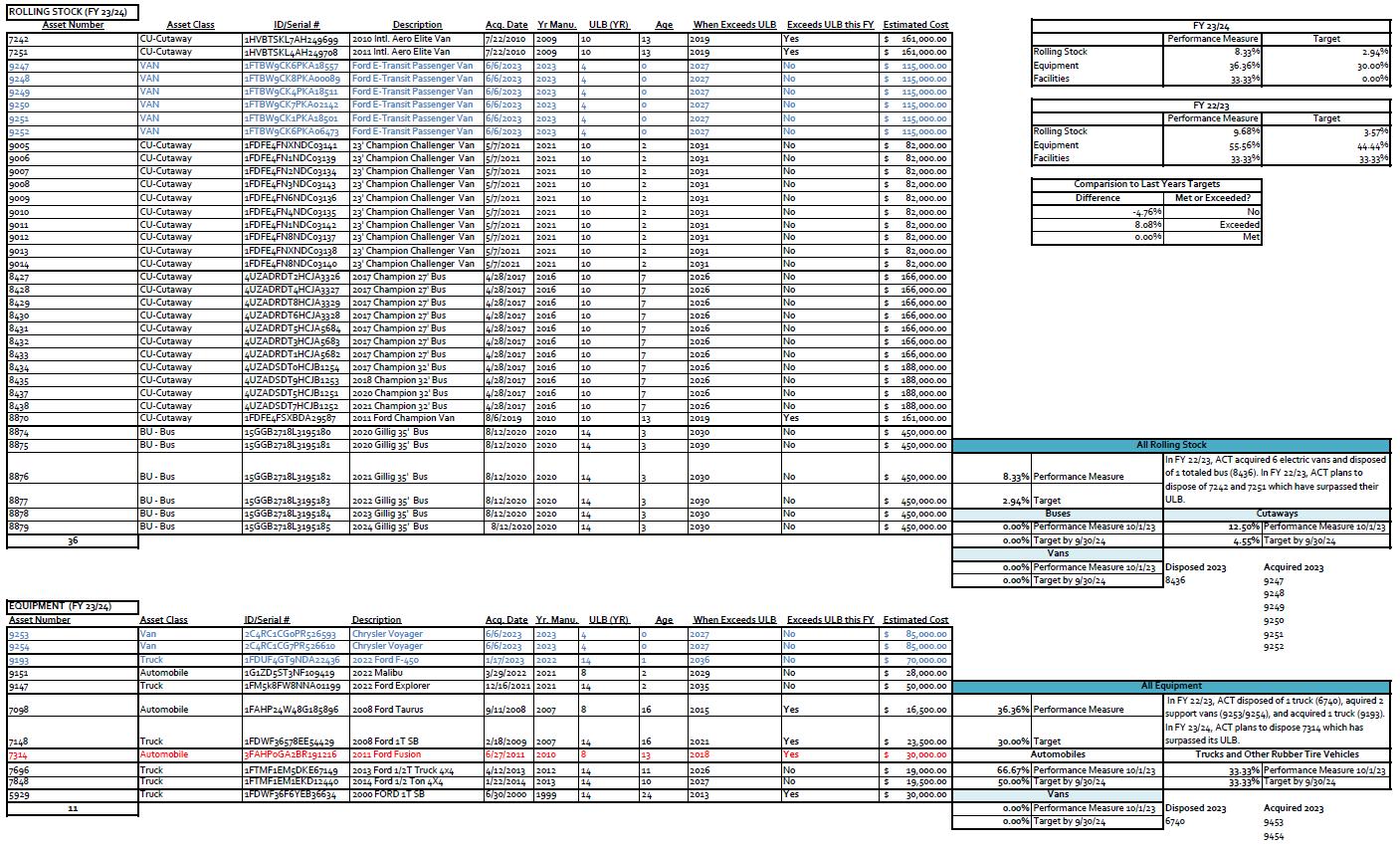
Amarillo City Transit (ACT) serves as the transit operator and designated recipient for federal transit funding within the urban service area. As required, ACT established State of Good Repair performance targets and objectives for both their urban and rural systems in their TAM. The TAM covers all fleet vehicles, as well as other capital assets to include equipment, rolling stock, infrastructure, and facilities.
Rolling stock is measured by the percentage of revenue vehicles (by type) that exceed the Useful Life Benchmark (ULB). Equipment is measured by the percentage of non-revenue service vehicles (by type) that exceed the ULB. Facilities are measured by the percentage of facilities (by group) that are rated less than 3.0 on the Transit Economic Requirements Model (TERM) Scale.
The Rolling Stock target for FY23/24 was set as 2.94%. To reach this target, ACT plans to dispose of two cutaway buses (currently pending disposal). The Equipment target was set at 30.00%. To reach this target ACT plans to dispose of one automobile that surpassed its useful life. The facilities target was set at 0.00%. To reach the target, ACT plans to complete the construction of a new transfer terminal. The Transit Asset Management plan is located here:
Transit Asset Management Plan
The FY23/24 Performance Measures and Targets were established, and the Amarillo MPO Policy Board Committee adopted the urban and rural performance targets identified as the MPO TAM performance targets for the region on January 18, 2024. Amarillo City Transit established the TAM performance targets on November 16, 2023. The inclusion of transit projects located in both the TIP and MTP are intended to support ACT in achieving the SGR performance measures for the regional transportation system.
Vision & Goals
Staff began the process of updating the MTP plan mission and vision statement. As part of this process, public workshops were held to solicit public feedback and input regarding the region’s transportation system, including a regional vision and goals. MPO staff created an online survey to receive comments and opinions, as well. Comments regarding the MPO vision focused on improving safety, reducing congestion, and providing a multi-modal transportation system.
The goals reflect the Eight Planning Factors identified in MAP-21 legislation that establishes nationwide performance goals for Federal highway programs. These performance goals will be integrated into transportation planning at the MPO level.
Vision Statement
The Amarillo Area MPO creates plans and strategies to move people and goods safely throughout the growing region to provide a safe, connected, and accessible multimodal transportation system for the Amarillo & Canyon region to improve the quality of life.
Mission Statement
The Mission of the Amarillo Area MPO is to enhance transportation, ensure safety and resiliency, and provide responsible allocation of available funding, by prioritizing development and economic growth, reducing congestion, adhering to multimodal connectivity strategies, and reaching targeted performance measures.
Goals
Safety Protect life and property from unintentional harm by developing policies, programs, and projects to support safer roadways and intersections, reduce fatalities, injuries, and improve mobility.
Performance Assess metrics to ensure the current and future ability of people and freight to travel to destinations on the network efficiently.
Resiliency Plan for and provide continued high level of service in the face of disruption or unexpected conditions, such as weather events, major incidents (or crashes), and infrastructure failures.
Efficiency Providing reliable, affordable, and safe transportation, connecting residents to jobs, goods, healthcare, education, and recreation.
Connectivity Plan for and improve interregional connectivity of I-40, I-27, Loop 335 by enhancing the integration and connectivity of the transportation system across all modes by
Chapter 2 MTP Development
connecting neighborhoods, commercial, employment areas, and community facilities.
Responsible Funding Plan for and require responsible financial stewardship and seek out innovative ways to fund projects.
Beautification and Landscaping
Use responsible design to coordinate with regional partners to adopt and maintain a uniform landscape and aesthetics master plan.
Economic Development
Encourage development in the Amarillo & Canyon region by prioritizing projects that align with current and future commercial, residential, and economic growth areas.
Objectives
Safety 1.1 Reduce pedestrian crash rate by planning and enhancing connected pedestrian infrastructure.
1.2 Reduce the number of fatalities and serious injuries.
1.3 Increase bicycle safety education.
Performance 2.1 Reduce congestion and improve travel time reliability to sustain adequate levels of service for all modes of transportation.
2.2 Plan and enhance intersections through analysis of corridor and network signalization to ensure traffic is flowing efficiently.
Resiliency
3.1 Prioritize transportation projects that add capacity or otherwise improve existing infrastructure.
3.2 Reduce stress and wear on existing infrastructure by improving system operations and develop vehicle demand reduction strategies.
Efficiency 4.1 Plan transportation systems that align with development trends to stimulate regional and local economic development.
Connectivity
Responsible Funding
Beautification and Landscaping
Economic Development
4.2 Plan for and provide mobility for current and future freight traffic volumes.
5.1 Prioritize projects that improve connectivity of the transportation system for all users and modes of travel.
5.2 Encourage projects that provide connectivity.
5.3 Plan projects that provide connectivity to existing and future employment, and education points.
6.1 Seek both traditional and alternative project funding sources and innovative funding mechanisms.
6.2 Be a good steward of category grant funds.
6.3 Leverage all available funds with additional funds from other entities and partners.
7.1 Encourage projects to use xeriscaping, artwork, and beautification along significant corridors such as the Portsto-Plains corridor.
7.2 Prioritize appropriate beautification projects using input from the Beautification Subcommittee.
7.3 Utilize public art that meets environmental demands of the roadside.
8.1 Plan for broader connection for all modes of transportation to economic development and land use.
8.2 Leverage transportation assets to support economic growth and vitality.
8.3 When evaluating and prioritizing projects, take economic implications into account.
8.4 Partner with local agencies and businesses that will expand job creation and retention.
Opportunities and Limitations
The Amarillo MPO serves as a vital entity responsible for coordinating transportation planning efforts within its designated boundary. This section of the MTP explores the opportunities and limitations of transportation within the MPO, identifying the region's transportation potential for future development.
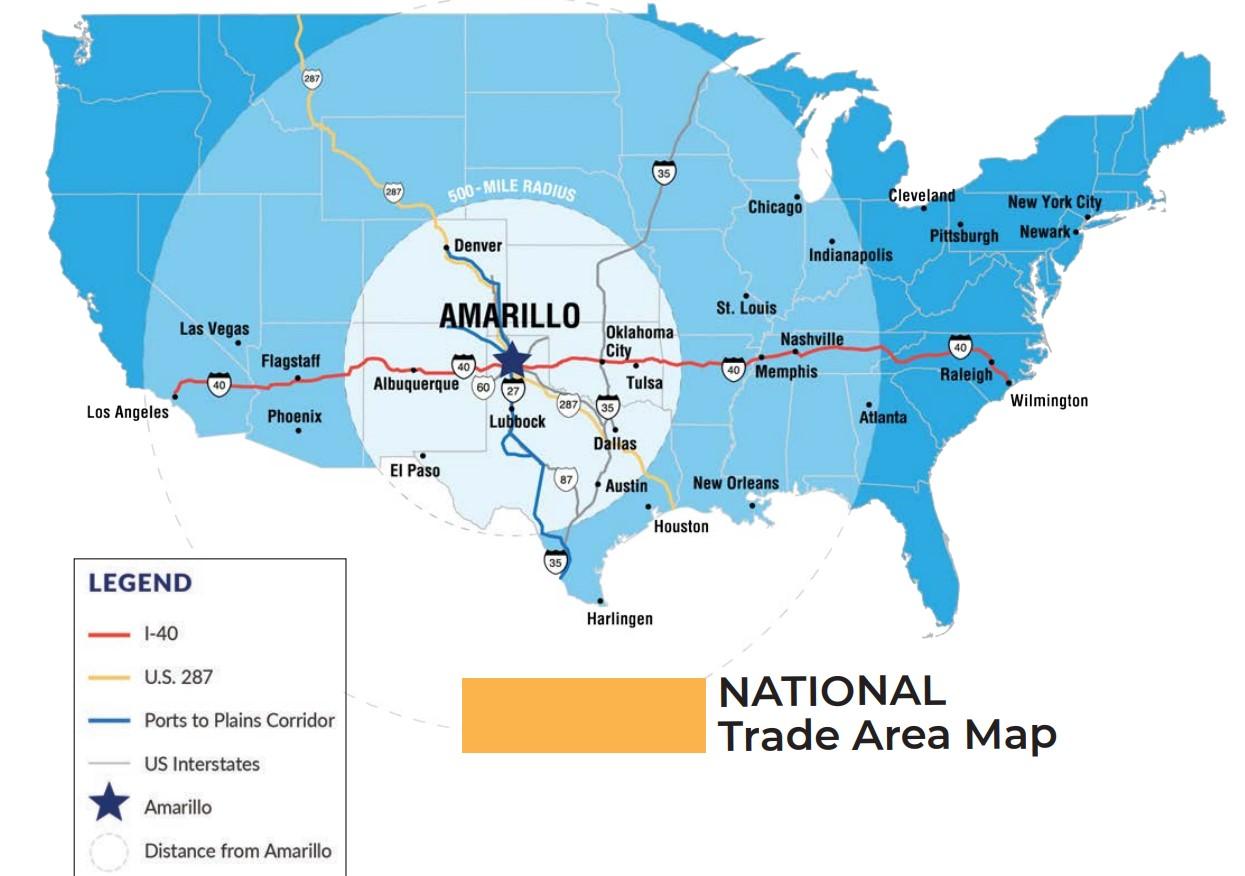
One of the primary opportunities within the MPO is the potential for economic growth and development. The strategic location of Amarillo as a transportation hub for the Texas Panhandle and its connection to major interstate highways, such as I-40 and I-27, makes it an attractive destination for businesses and industries looking to expand or establish a presence in the region.
One of the most important aspects of the MTP plan is to ensure that the elements contained within the plan are based on a realistic estimation of the resources and needs of the citizens in Amarillo. Realizing these factors, it is necessary to identify opportunities and limitations that are present within the Planning Area and are unique to the region. This information will be useful in developing strategies and implementing the elements included in this plan.
Mobility in the Planning Area is currently very good. A few areas of the city are experiencing intermittent congestion and travel delays. To date, these problems are limited to peak hour times at major intersections. Since traffic congestion and delay problems have not yet reached severe levels, citizens have not sought alternative modes of transportation. Currently, with minimal traffic problems, some of the biggest limitations in developing a multimodal transportation system that citizens will use include:
•Vehicle dependence
•Single occupant trips
•Low cost of vehicle operation
•Low travel times within planning area
•Trip Chaining (grouping errands into one trip)
MPO staff plans for increased travel demand. Limited resources force staff to look at alternative modes for moving people and goods. The long-range plan provides an opportunity to focus on future needs and identify ways to curb problem areas before they occur. The major opportunities that exist for the transportation system in the Planning Area include:
• Maintaining, upgrading, and expanding the existing roadway system
• Managing and reducing existing congestion
• Improving mobility via preservation and expansion of existing highway corridors
• Providing improved public transportation services
• Creating a safe and efficient bicycle network
• Providing improved pedestrian facilities
The MPO boundary offers opportunities for developing a robust multimodal transportation system. With its extensive highway network, existing railroads, and Amarillo Rick Husband International Airport, the region encourages seamless integration of different transportation modes. The MPO works to enhance mobility, reduce congestion, and provide commuters and businesses with more transportation choices, ultimately contributing to a more sustainable and efficient transportation system. To improve Amarillo MPO regional network mobility, the following policies are considered:
•Minimize adverse effects on the community's social, cultural, economic, and environmental resources.
•Incorporate various modes of transportation into new road designs to foster a diverse and efficient transportation system.
•Prioritize operational enhancements as an alternative to increase capacity whenever feasible.
•Limit or avoid capacity increases in existing neighborhoods.
•Optimize signal synchronization to enhance overall efficiency.
•Continue ongoing maintenance programs to preserve the existing roadway infrastructure.
Sustainability is a growing nationwide concern, and the MPO considers sustainable transportation initiatives by investing in public transportation, active transportation infrastructure (such as bike lanes and pedestrian pathways), and clean energy solutions.
Exhibit 8 Vision, Mission, and Goals Matrix
Amarillo MPO's role in coordinating transportation planning across multiple jurisdictions presents an opportunity for collaborative efforts. By fostering partnerships with local governments and stakeholders, the MPO creates a comprehensive and unified vision for the region's transportation system. Collaborative planning results in better-funded projects, improved project prioritization, and a coherent transportation network.
One of the primary limitations facing the Amarillo MPO is the availability of funding for transportation projects. While there are significant infrastructure needs in the region, securing adequate funding can be a challenge. The MPO continuously explores various funding sources, including federal grants, state allocations, and partnerships, to address these limitations and support its transportation goals effectively.
Urban sprawl is another limitation that challenges transportation planning in the Amarillo region. Expanding development patterns can lead to increased congestion, longer commute times, and higher infrastructure maintenance costs. MPO addresses these issues by promoting sustainable land use planning, encouraging transit-oriented development, and implementing policies that manage urban sprawl successfully.
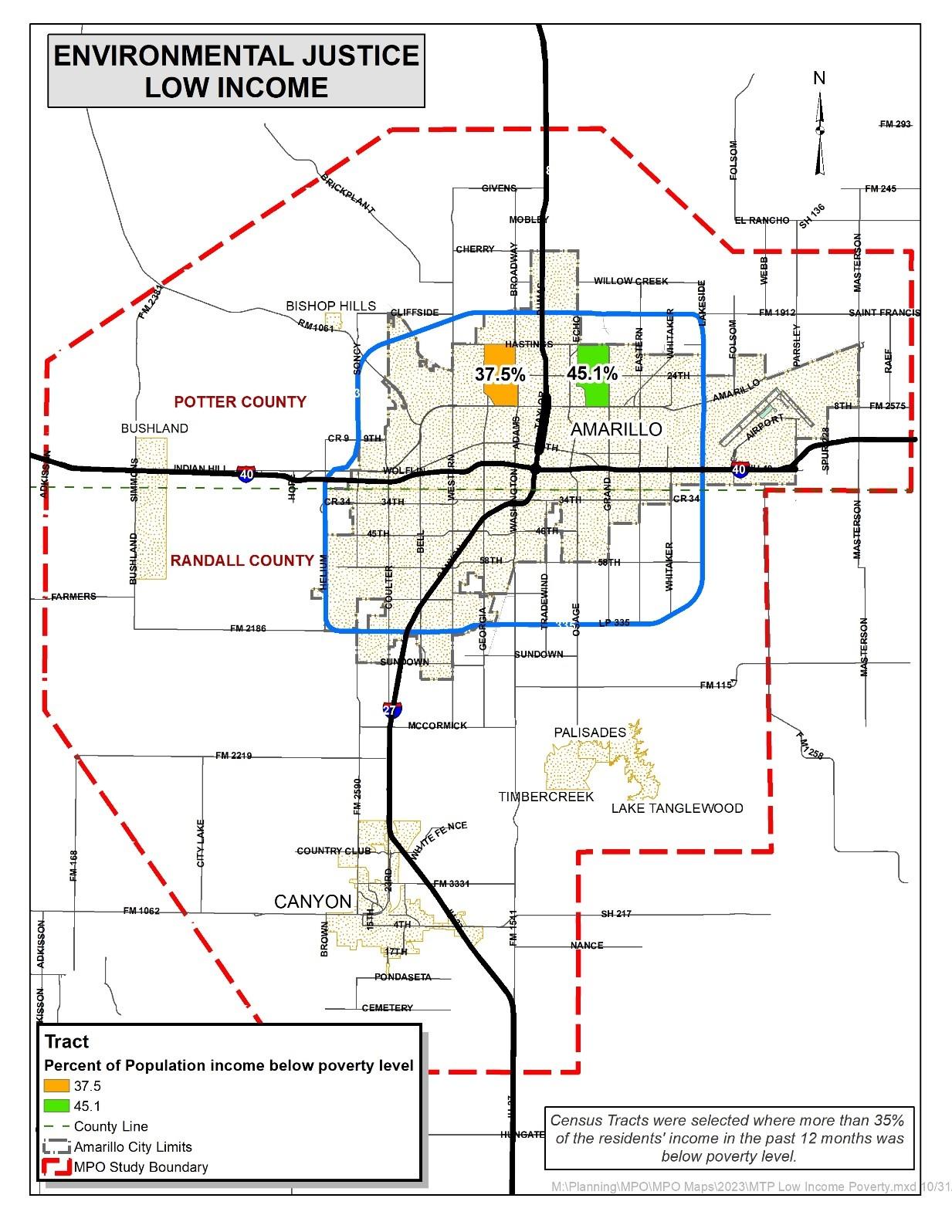
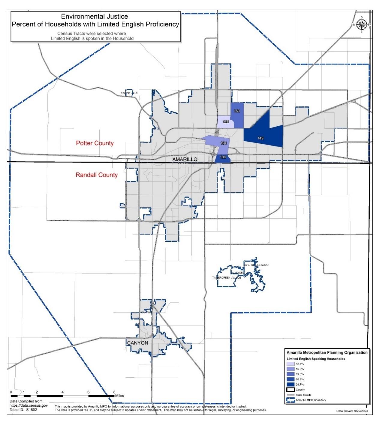
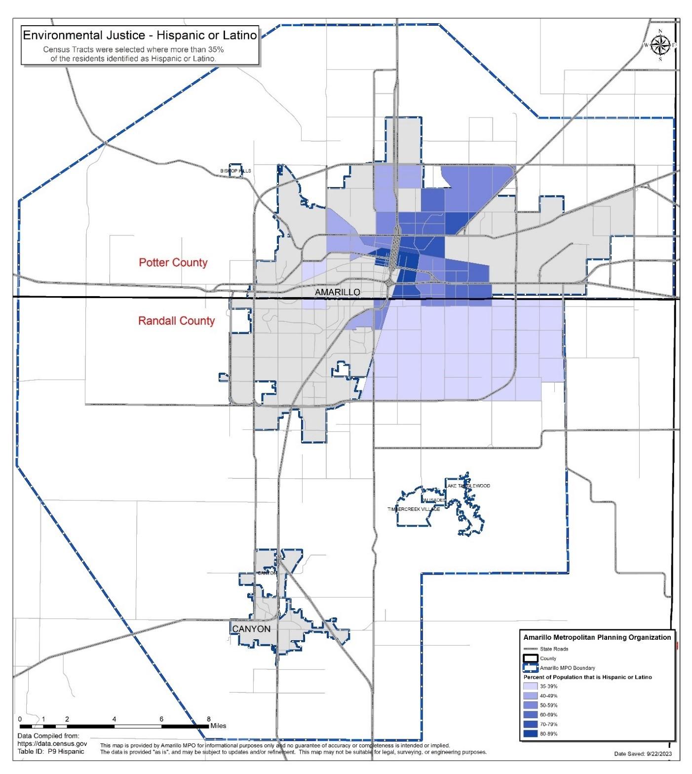
Transportation equity remains a nationwide concern, with some communities in the region facing limited access to transportation options. Low-income neighborhoods, rural areas, and underserved populations may have inadequate access to public transportation and face
barriers to mobility. To overcome this limitation, the Amarillo MPO prioritizes investments that enhance transportation equity, such as expanding public transit services and improving connectivity to underserved areas.
Many parts of the transportation infrastructure within the MPO are aging and in need of repair or replacement. Addressing this limitation requires a strategic approach to asset management, prioritizing rehabilitation projects, and seeking innovative solutions to extend the lifespan of critical infrastructure assets.
The Amarillo Metropolitan Planning Organization's role in shaping the future of transportation within its boundary is both a challenge and an opportunity. By capitalizing on its strategic location, fostering collaboration, and addressing funding limitations and equity concerns, the Amarillo MPO works towards a transportation system that supports economic growth and improves the overall safety for its residents. However, it must remain vigilant in addressing the limitations that impede progress, ensuring that transportation planning is adaptive, responsive, and focused on the long-term well-being of the entire community.
Performance-Based Planning and Programming
The FAST Act, initiated in MAP-21, improved transportation planning, both at metropolitan and statewide levels. The processes include the integration of performance goals, measures, and targets into the selection of transportation projects. Public engagement plays an important role throughout the planning process. Performance-based planning and programming includes the use of performance management strategies to attain targeted outcomes for the multimodal transportation system.
The aim is to ensure that decisions regarding transportation investments are grounded in well-established objectives. The Amarillo City Transit (ACT) is dedicated to enhancing both existing and future facilities to alleviate congestion and bolster safety. The newly implemented transfer station boasts cutting-edge technology and logistical planning. Likewise, the City of Amarillo Street Department optimized numerous intersections, employing signal optimization to mitigate congestion, and enhancing signage and overall intersection infrastructure. The Secretary of Transportation establishes specific quantitative criteria for assessing goal attainment. Amarillo MPO's Goals, Objectives, and Performance Measures align with the state's performance targets. The MPO actively engages the public to gather input to refine the Metropolitan Transportation Plan (MTP). The MPO's planning efforts include performance targets that are assessed during project selection. Staff reviews and reports on the condition and performance of the transportation system to gauge the achievement of performance measures. This ongoing process of monitoring and evaluation enables a deeper understanding of successful approaches and informs future decisions related to the transportation system.
MTP Development Process
The MTP development planning process includes the MPO developing a vision, creating
policies and strategies to support the vision, and presenting a continuing approach. The MTP programming should include prioritizing proposed initiatives, matching projects with available funds, and establishing short-term goals. To be eligible for Federal transportation funding, the planning process reflects the “3C” approach; comprehensive, cooperative, and continuing.
Project Selection Process
Amarillo MPO member entities such as TxDOT, municipalities and counties, are encouraged to submit proposed improvements and/or new transportation projects due to development and noticeable changes in usage. MPO staff requires sufficient time to analyze, research, and compile all the project information, so a deadline is set and made known to the member entities. In so doing, MPO member entities determine the transportation needs of the region by the development of projects. The application should factor in important MPO goals, such as, including multimodal aspects, bike/pedestrian, freight issues, safety, resiliency, congested roadway, or special generators.
Project Prioritization
Amarillo MPO prioritizes roadway projects in the MTP in accordance with the approved Project Selection Process. This process combines technical and subjective scores and results in a final score and ranking to determine the regional priorities. The committee membership consists of members from the TxDOT–Amarillo District and City of Amarillo, Potter and Randall County Road and Bridge Superintendents, City of Canyon, and MPO staff. Public involvement was solicited and encouraged at every level of the development process.
MPOs are required to have transportation projects listed in a Metropolitan Transportation Plan (MTP), a long-range, twenty-five-year plan. There can be a vast number of projects listed as future needs in the MTP. The Transportation Improvement Program (TIP) is a listing of projects selected for construction during the next four years. Projects are advanced from the MTP to the TIP through various planning efforts.
Once a project moves from the MTP into the TIP, public expectations are raised. The citizens expect to start seeing progress of the project. The Moving Ahead for Progress in the 21st Century Act (MAP-21), furthered by the Fixing America’s Surface Transportation (FAST) Act, requires the MTP and the TIP be fiscally constrained; therefore, only projects that have a reasonable expectancy of being funded should be included. As such, there is a greater need to prioritize the projects to be advanced from the MTP into the TIP.
Participation of all transportation stakeholders is paramount to this process. The MPO holds public meetings to inform stakeholders about project listings considered for the long and short-range planning documents. Projects in the TIP need to support the goals of the long-range plan. There can be projects that have a lot of public support but do not qualify for the TIP because of other reasons.
Since funding is limited and many projects must compete for funds, it is very important
Chapter 2 MTP Development
to have a means to evaluate each project and compare them. The MPO uses a Project Prioritization Methodology (PPM) Matrix and the current TxDOT Performance Based Planning Software to rank each project based on the project’s own merits on an annual basis. These are both to be used as decision making tools, and once projects are ranked, the Technical Advisory Committee and the Policy Committee have a way to compare projects; however, the Policy Committee is not bound to use the rankings from these tools as the sole reason for deciding. The key factors used to evaluate projects based on MAP-21 and FAST Act include:
• Support the economic vitality of the metropolitan area.
• Increase the safety of the transportation system for all motorized and non-motorized users.
• Increase the ability of the transportation system to support homeland security and to safeguard the personal security of all motorized and non-motorized users.
• Increase accessibility and mobility of people and freight.
• Protect and enhance the environment, promote energy conservation, improve the quality of life, and promote consistency between transportation improvements and State and local planned growth and economic development patterns.
• Enhance the integration and connectivity of the transportation system, across and between modes, for people and freight.
• Promote efficient system management and operation.
• Emphasize the preservation of the existing transportation system.
• Environmental Mitigation and Consultation
• Title VI and Environmental Justice
• Public Participation
• Improve resiliency and reliability of the transportation system and reduce or mitigate stormwater impacts on surface transportation; and
• Enhance travel and tourism.
Project Submission
A call for proposals will be sent to citizens and transportation stakeholders within the Amarillo MPO area. In addition, during the revision of the MTP process a call for projects will be hosted in conjunction with the MPO Policy Committee meeting. Stakeholders wishing to submit a proposal will present a completed Project Selection Form to the MPO.
Project Review and Evaluation
In addition to the following PPM Matrix ranking, the current TxDOT Performance Based Planning Software can be used as a common platform across the state to help view how projects might rank compared with others from around the state. The Project Prioritization Methodology as well as TxDOT’s Performance Based Planning Software (Decision Lens) was used in the selection process.
The following requirements will determine which projects, based on a 100-point scoring system, are eligible for possible inclusion in the financially constrained component of the MTP:
• Proposed projects will be consistent with the MPO's long-range goals.
• Proposed projects will have an identified funding source.
• Proposed projects will have a project implementation timeline and other details necessary to complete the Project Selection Process.
Projects not meeting these requirements may be included in the MTP under an unconstrained needs component. These projects will be advanced by the adopted MTP, should additional funds become available. As the MTP planning forecast is revised or when new information is available on projected funding levels, a re-evaluation of MTP projects will be deemed necessary. Projects complying with the previous requirements will be evaluated based on the following criteria:
1. Planning & Mobility Concerns (32 total points) Does the project support established prioritized goals and improve the local and regional transportation network; improve capacity, connectivity, or provide congestion relief; is the project part of a planned corridor?
• Support MPO & regional prioritized goals.
• Support MAP -21 and FAST Act planning factors.
• Support economic development.
• Improve connectivity.
• Address roadway capacity Issues.
• Address congestion relief.
2. Traffic& Safety Factors (28 total points) Does the project address issues such as safety, traffic flow, freight movement, accessibility, and multi-modal operations?
• Traffic volumes & percentage of trucks
• Access management improvements
• Intersection/interchange improved.
• Expand multi-modal options.
3. Cost Effectiveness & Affordability (15 total points) This is intended to be an indicator of the economic viability of the project; calculated as cost per mile.
• Construction costs
• Rights of way costs
• Project length
• Traffic volumes
4. Other Factors (25 total points) Have sufficient measures been addressed to ensure the timely development of the project; is it well supported by the participating entities?
• R-O-W & engineering schedules
• Environmental & utilities schedules
• Multiple local entity support
• Third party funds availability
An adopted project selection process was used to determine the projects included in the plan. The Project Prioritization Methodology matrix. MPO staff compiles technical data from its member entities, TxDOT, and the transportation model. The Technical Advisory Committee participates in the subjective scoring element. During the scoring process, staff note anomalies in
the technical data for Board Members to reexamine whether the previously adopted process is still currently the best method to evaluate project priorities in the region.
To complete the prioritization process for the MTP, staffengaged TAC members in the review of projects proposed for inclusion in the financially constrained component of the MTP to ensure the criteria state in the approved project selection process are met. The Project Selection Process consists of three steps:
1. Project submission
2. Project review and evaluation by Technical Advisory Committee to develop recommendation to MPO Policy Committee.
3. MPO Policy Committee review and approval.
The projects are designed to meet the projected future transportation demand for the Amarillo MPO Boundary Area. Projects in this plan were selected based on the demand identified by transportation planners, population projections, public input and use projections and system deficiencies. The projects selected for the roadway plan are designed to improve mobility in the Amarillo MPO Boundary Area and expand the existing network.
A well-planned highway and arterial street system is vital to the Amarillo MPO Boundary Area. The pattern of vehicular movement provides the framework upon which the Amarillo area develops and is of great significance to the future growth of the region. As past improvements have made an impact on the present, future facilities will provide the framework upon which Amarillo will continue to expand.
The members of the MPO Technical Advisory Committee collaborated in the selection of transportation projects included in this plan. This prioritization process was completed for this MTP update and the resulting project listing is found in Exhibit 34 Fiscally Constrained Project List – Amarillo Metropolitan Transportation Plan 2025-2050.
The MPO member entities develop a comprehensive list of regional transportation priorities to guide the MPO in their selection of future projects for the region.
Policy Considerations
To improve the mobility on Amarillo's network, the following policies should be considered:
• Minimize negative impacts on the social, cultural, economic, and environmental resources of the community.
• Include alternative modes of transportation in all new roadway designs to promote a multimodal system.
• Utilize, whenever possible, operational improvements as an alternative to capacity increase
• Limit or avoid capacity increases in existing neighborhoods.
• Maximize signal synchronization to promote efficiency.
• Continue maintenance programs to preserve the existing roadway system.
Technical Advisory Committee Review of the MTP Plan
The Metropolitan Transportation Plan (MTP) is crafted by the MPO as they engage in a process of revising statistical and technical data to support transportation efforts. The plan encompasses anticipated growth and travel patterns, insights gathered from public input, and initiatives from various entities, for a 25-year period. The draft plan is presented to the Technical Advisory Committee (TAC) for their input, review, and approval, then it is forwarded to the Policy Board Committee.
The Policy Board Committee conducts a thorough examination of the MTP plan prepared by staff and recommended by TAC members. Following their review, approval is granted for staff to initiate the public engagement process. Once the public comment period concludes, the PBC deliberates on final approval. The goal is to achieve a consensus among elected officials, TXDOT, the TAC Board, and the public regarding future transportation in the region.
MPO Policy Committee Review and Approval
Once projects are recommended by the Technical Advisory Committee, the MPO Policy Committee considers these projects for inclusion in the MTP. Public involvement and comments will be solicited in compliance with the Amarillo MPO’s Public Participation Plan. This process of project selection and moving a project forward to the TIP is a cooperative effort within the Amarillo MPO.
Financial Projections
The Policy Board Committee reviews the funding and selects projects that most reasonably reflect projected growth and revenue for the region. This review of funding involves Federal, State, and local funds that allow staff to forecast what types of funding will be available in the short and long-range plans. The outcome is a list of regionally prioritized projects.
Using the
Amarillo
MPO Project Prioritization Methodology Matrix
Prioritization Process:
To be considered eligible a project must be:
• In the Metropolitan Transportation Plan (MTP) project listing or recommended for such listing by the Technical Advisory Committee.
• Roadway projects must be functionally classified by the Federal Highway Administration as a collector roadway or better.
• Eligible for TxDOT Category 2, 3, 4, 7, 9, 10, 11, 12, or other MPO and/or Public Transportation funding, as awarded by TxDOT or USDOT.
Chapter 2 MTP Development
The Amarillo Metropolitan Planning Organization (MPO) is committed to creating a transportation system that serves the diverse needs of the community. Public participation and involvement are core tenets of the Metropolitan Transportation Plan (MTP) development process. The MPO employs a multi-faceted approach to reach a broad spectrum of the population.
Public involvement efforts include public meetings, workshops, focus groups, surveys, online engagement platforms, and collaboration with community organizations to acquire the opinions of the public on the regional transportation system. MPO staff solicit feedback, surveys, and interactive mapping about congestion, safety, transit, bicycle and pedestrian facilities, and project selection. This approach ensures that various demographics and stakeholder groups are represented, making the planning process more inclusive and equitable. USDOT guidelines for full representation from the community require documentation of the community’s impact on decisions.
The MPO employs best practices to engage the public in a meaningful way, as required by the legislation below:
• The Transportation Equity Act of the 21st Century (TEA-21)
• The Intermodal Surface Transportation Efficiency Act of 1991 (ISTEA)
• Texas Open Meetings Act
• Title VI of the Civil Rights Act of 1964 and Environmental Justice (EJ)
• National Environmental Policy Act of 1969 (NEPA)
• The American with Disabilities Act of 1990 (ADA)
The MPO holds in-person workshops, including areas in the Environmental Justice zones. The workshops were promoted in the newspaper, posted in public buildings, on the MPO website and social media, the Amarillo ISD newsletter, and word of mouth. The public and elected officials were invited to complete the workshop survey online. Upon receipt of the feedback, workshop participants were asked to vote on how they would like to see funding allocated for transportation in the region and helped guide the decision-making process. The outcome was that the public gained knowledge of the transportation planning process and provided feedback to guide future planning decisions.
Chapter 2 MTP Development
To facilitate informed participation, the MPO provides educational materials that explain complex transportation concepts, funding mechanisms, and potential impacts. Amarillo MPO incorporates best practice tools from the FHWA, including workshops, webinars, online surveys, and project visualizations. By enhancing public understanding, the MPO empowers diverse and often underrepresented individuals to contribute meaningfully to the planning process.
The MPO engages with local government agencies, advocacy groups, business and environmental organizations, and other stakeholders. Ensuring different perspectives are considered in the MTP development, joint planning sessions are utilized to gather valuable insights.
Effective and meaningful public involvement begins at the start of the planning process. By involving the public early and continuously, the MPO incorporates community input into the foundation of the MTP to identify possible impacts to the public. This approach helps to discover key issues and concerns, assuring that the plan addresses the most pressing transportation needs, especially from underserved populations.
Member entities such as TxDOT, municipalities and counties, are encouraged to submit proposed improvements and new transportation projects. For MPO Staff to have sufficient time to analyze, research, and compile all the project information, a deadline is set for submission. MPO TAC decides the transportation needs of the region by submitting projects that address those needs.
Amarillo MPO studies equity and fairness in mobility and accessibility to meet the needs of all community members and seeks to facilitate social and economic equity by providing affordable transportation options. Considering equity early and often through the process of public participation, data collection, and analysis improves the planning process.
Providing clear and accessible information is crucial for successful public participation. The MPO ensures that materials are presented in plain language, avoiding jargon, and making use of visual aids to enhance comprehension. The website is translated using Google Translate with several languages to choose from. Materials are available in different languages upon.
The City of Amarillo employs a new AI “digital human” chatbot that speaks 62 different languages. Citizens who have limited English proficiency may go to the www.amarillo.gov webpage to access the services and ask questions in their native language and get interactive answers to complex interactions in that language to ensure that all citizens receive equal service.
Using the Environmental Justice Screening and Mapping Tool Community Report from the EPA https://ejscreen.epa.gov/mapper/, Amarillo MPO can find and analyze areas by Census Tract of potential Limited English Proficiency, environmental and socioeconomic concerns. This approach allows the MPO to cater to a diverse audience and fosters active engagement.
Chapter 2 MTP Development
The MPO emphasizes a two-way communication approach. This involves not only disseminating information to the public but also actively listening to their feedback. Through public meetings, open houses, and online platforms, the MPO encourages dialogue for public input into the decision-making process.
Exhibit 9 Environmental Justice LEP
Chapter 2 MTP Development
To ensure accountability and transparency, the MPO maintains records of public participation efforts, including the methods used, the number of participants, and the main themes of discussions. Regular reports on public involvement activities are shared with the public and relevant authorities, demonstrating the MPO's commitment to inclusive planning. Amarillo MPO develops a comprehensive participation plan outlining public involvement activity and considers diverse communication channels to reach a broad audience. Amarillo MPO focuses on creating opportunities for meaningful public involvement that:
• Increases trust between the organization and the community.
• Increases the likelihood that projects, programs, or plans will be accepted.
• Creates more effective solutions.
• Improves a community’s knowledge of the projects.
• Empowers people from different backgrounds to become involved in transportation decision-making.
• Delivering a better project with diverse ideas that promote equity and inclusion.
• Recognizes authorities, such as Title VI and NEPA, that require public input and nondiscrimination.
Public participation is at the center of the Amarillo MPO's efforts to develop a comprehensive and effective Metropolitan Transportation Plan. The MPO Policy Board Committee adopted the Public Participation Plan on October 19, 2023, and can be found on the webpage at www.amarillompo.org
As part of the public participation and interagency meeting efforts, citizens and stakeholders reviewed the MTP draft and commented. The members of the MPO Technical Advisory Committee (TAC) and the Policy Board Committee also reviewed and adopted the draft.
Public notices were posted about the draft on the webpage, in local libraries, and at the offices of the member agencies. The MPO provided public notice, calendar information, and press releases in the Amarillo Globe News, the region’s largest daily newspaper publication.
By adhering to the requirements set forth by the FAST Act and the IIJA/BIL law and implementing best practices for public involvement, the MPO ensures that the transportation system reflects the needs, aspirations, and values of the community it serves. Through continuous engagement, collaboration, and transparency, the MPO aims to create a transportation network that works for all residents of the Amarillo metropolitan area.
Public Participation
Effective transportation planning must be responsive to the needs of the community and therefore effective public input is essential. The FAST Act requires the MPO to provide citizens, affected public agencies, freight transportation services, private providers of transportation, representatives of users of public transportation, the disabled community, users of pedestrian
Chapter 2 MTP Development
and bicycle facilities, and other interested parties with a reasonable opportunity to comment on the MTP, the TIP and other documents prepared by the MPO. FAST Act also requires the MPO to consult, as appropriate, with State and local agencies responsible for land use management, natural resources, environmental protection, conservation, and historic preservation concerning the development of long and short- range transportation plans. The MPO maintains a website www.amarillompo.org that includes this MTP, the TIP, and other documents that the MPO produces.
The MPO Policy Committee adopted a FAST Act compliant Public Participation Plan on October 19, 2017, which encourages early and continuous public participation in the planning process. The Public Participation Plan can be found at: http://www.amarillompo.org Communication is encouraged through the publication of public notices, agendas, and news releases. The MPO staff also seek invitations from civic, social, educational, and business organizations to present information about the MPO planning process. The MPO has prepared literature to educate citizens and officials. Materials are available that discuss aspects of shortand long-range transportation planning, public participation, as well as information about local transportation initiatives.
As part of the public participation and interagency consultation efforts, the draft MTP was made available for review and comment to citizens, bicycle and pedestrian representatives, disabled representatives, federal, state, and local resource agencies, land use management, natural resource, environmental protection, and conservation, historic preservation agencies, in addition to transportation stakeholders with interest in the MPO planning area. The members of the MPO Technical Advisory Committee and the Policy Committee also reviewed the draft and public notices were released about the draft being placed on the MPO web page, in local libraries, and at the offices of the member agencies.
The MPO meets the requirements of the public notice of public involvement, by placing notices, calendar information, and press releases in the Amarillo Globe News, the region’s largest daily newspaper publication.
Public Comment
Public meetings were held across the area and public comments were compiled. Additionally, copies of notices of public forums and hearing are included. This includes Environmental Justice areas and the City of Canyon. MPO staff hosted a public meeting at the Amarillo Downtown Public Library on April 10, 2023, at 4:30-7:00 pm and at Canyon Cole Community Center on April 13, 2023, at 4:30-7:00 pm. Additionally, MPO staff hosted a public meeting at the Amarillo Downtown Public Library on November 7, 2023, at 4:30-7:00 pm and at Canyon Cole Community Center on November 9, 2023, at 4:30-7:00 pm. Comments are located as Exhibit 43 2024 Amarillo MPO Public Comments
Chapter 2 MTP Development
As the planning process begins with the public, it also concludes with the public. As required by the Public Participation Plan (PPP), two public meetings are held to allow for public involvement and to initiate the public comment period. This allows the transportation users to have input on the final draft before the plan is officially adopted. The outcome is for the public to again be consulted for final input and confirm that the developed plan meets future transportation needs of the region.
Plan Adoption
Members of the Technical Advisory Committee and Policy Board Committee carefully examine the public input before formally endorsing the revised Metropolitan Transportation Plan for the Amarillo Metropolitan Planning Organization (MPO). This step results in the Amarillo region gaining an up-to-date projection of its transportation requirements while maintaining an ongoing commitment to monitoring and analyzing the transportation challenges it faces.
March 26, 2025
Chapter 3 Trends in the Amarillo Urban Area
The Amarillo Metropolitan Planning Organization (MPO) acknowledges the nature of changing transportation systems and the need to anticipate and adjust to emerging trends. As the Metropolitan Transportation Plan (MTP) is developed, it becomes important to assess new trends that will affect the transportation environment in the Amarillo metropolitan region in the foreseeable future. These trends are projected to impact transportation planning, infrastructure, and services, including a surge in population and workforce, as well as an uptick in travel to the Amarillo area.
The study area encompasses a diverse array of communities, each with unique ideas for the expansion and alignment of transportation infrastructure to meet present and future demands. The demographic differences in population density, age, and socioeconomic status within these community’s present challenges the MPO must evaluate. The Amarillo area's strategic location in the center of the Texas Panhandle, offers access to both Interstate 40 and Interstate 27, along with the Amarillo Rick Husband International Airport, highlighting its significant strengths. Also, the area offers a state university, a junior college, an assortment of light industries, and multiple medical facilities, all of which are expected to propel ongoing development and commerce into the future.
Regional Overview
The Amarillo MPO resides in the Texas Panhandle serving a diverse area characterized by an expanse of approximately 594 square miles. Planning for future transportation facilities requires evaluating many factors. Demographic, economic and travel trend data are valuable tools for forecasting transportation needs that may exist in the future.
Evaluating historic trends and future projections can be helpful in planning the transportation system of the future. A growing population and economy indicate that there will be an increased demand for the transportation system. The following is an evaluation of the population, work force, and travel trends in the Amarillo Metropolitan Area.
The boundary includes the City of Amarillo, the City of Canyon, the Village of Lake Tanglewood, the Village of Timbercreek Canyon, the Village of the Palisades and unincorporated portions of Potter and Randall Counties. The area has seen substantial growth in terms of population, housing, business activity, and traffic. It is a dynamic and diverse region.
Exhibit 10 Population Projections 2020-2050
The Population Growth Chart shows growth expectations for the Amarillo Metropolitan Planning Organization (MPO) during the period from 2020 to 2030, with a rise of 29,601 residents. Among the counties within the Amarillo MPO, Randall County is displaying the most significant percentage of growth. Conversely, Potter County is expected to increase by a smaller margin. In summary, Randall County is expected to continue to grow southwest of Amarillo, while Potter County is expected to remain neutral during the next 25 years.
Exhibit 11 Amarillo MPO Demographics
Population Trends
The City of Amarillo has experienced varying growth rates over the past 100 years. Population growth has been recorded for all entities in the Amarillo area, except Potter County. Amarillo has seen rapid population growth throughout its history, which is only expected to continue. The Amarillo MPO boundary population is expected to grow, even with shrinkage from Potter County’s population, due to Randall County’s population growth of 20.6%, which outpaced Texas 19% and nationwide 7.7% growth.
Growth in the Planning Area has continued to move to the northwest and southwest portions of the city over the past decade, as is indicated by the rising population of Randall County which is in the southern portion of the Planning Area. Other areas within the planning boundary have experienced population decreases due to declining birth rates, migration, and housing stock reductions. These areas are primarily located in the central, north, and east portions of the city.
The urbanized regions within the MPO boundary have a more youthful population, while certain villages in the more rural areas comprise of a comparatively older demographic profile. This disparity can be attributed to the presence of colleges and universities, thriving industry sectors, and abundant economic prospects that attract a younger demographic to urban areas.
In Potter and Randall Counties, the median age is 36 years old. Adjacent incorporated regions have a higher median age of 44 years old, such as Bishop Hills, and the Palisades village. Meanwhile, Lake Tanglewood and Timbercreek Canyon village have a considerably higher median age of 61 years old. Within the City of Amarillo, the median age mirrors that of Potter and Randall Counties. In contrast, the City of Canyon reports a notably lower median age of 27, which can likely be attributed to the presence of West Texas A&M University and a significant 35% of the population falling within the 15 to 30-year age bracket. Across the entire MPO urbanized area, the median age remains consistent at 36 years old.
Exhibit 12 Population Projections 2020-2050
Potter County population is 118,525, and the economy employs 50,661 people. The
median property value in Potter County was $102,000, and the homeownership rate in Potter County is 59%. Median household income in Potter County is $45,096. The largest industries in Potter County are manufacturing, health care, social assistance, and construction. The highest paying industries are Mining, Quarrying, Oil & Gas Extraction, Professional Scientific Technical Services, and Agriculture, Forestry, Fishing & Hunting, and Mining. The largest universities and colleges in Potter County are Amarillo College, with 1,154 graduates Spring 2024, Wade Gordon, and Milan Institute.
Poverty continues to be a challenge in the Amarillo area. In 2022, 20% of the population was living with severe housing problems in Potter County, 16% of the city of Amarillo was below the poverty level. The city of Amarillo conducted a “Point-in-Time” (PIT) count, a 24-hour survey of homeless population in January 2024, and the number of the unhoused was 692, an increase of about 150 people from 2023. Poverty in Randall County appears to be less dire at 10% living below the poverty line.
Exhibit 13 Median Age Table
In March of 2024, Randall County, with a population of 140,753, employs 71,000 people. In 2024, the median property value in Randall County was $320,000, and the homeownership rate was 69.3%. In 2021, Randall County had a population of 139k people, a 2.33% increase from 2020. The median age of 36.2 and household income of $76,744. The largest industries in Randall County are health care, social assistance, retail trade, and educational services. The highest paying industries are Utilities, Manufacturing, Mining, Quarrying, and Oil & Gas Extraction. The largest university in Randall County is West Texas A & M University, awarding 1,100 degrees in
Spring of 2023.
Exhibit 14 Demographics by County
The Amarillo MPO area boasts an incredibly diverse population In the broader MPO area, around 73% of its residents identify as Non-Hispanic White or Caucasian, followed by 11% who identify as Two or More Races. Also, 7% of the population identifies as Black or African American, while 4% classify as Asian. Native American or Alaskan Native individuals represent 0.8%, and 0.2% identify as Hawaiian or Pacific Islander
Randall County has the highest Median Household Income, standing at $68,186, while Potter County is lower at $43,652. Despite the United States' Median Household Income being $64,994, certain regions within the MPO area fall below this national benchmark. It is imperative to pinpoint these underserved areas, along with those characterized by substantial minority populations. This identification process is crucial to ensure equitable treatment and meaningful engagement of marginalized groups in the development and execution of transportation projects.
Chapter 4 Plan Elements
Exhibit 15 Amarillo MPO Population Breakdown
AMARILLO MPO BOUNDARY RACIAL CHART
Exhibit 16 EJ Percent of Households Below Poverty Level
Chapter 4 Plan Elements
Clearly mapping these populations highlights the concentrated areas of Minority, Hispanic, Limited English Proficiency, and Low-Income residents within the MPO planning boundary. Through a comprehensive analysis of this demographic information, staff have identified specific areas within the boundary that qualify as Environmental Justice zones. The Amarillo MPO will continue to focus the public outreach efforts to specific EJ areas as described in the Title VI Plan.
Chapter 4 Plan Elements
Exhibit 17 Limited English-Speaking
Exhibit 18 Hispanic Households Map
Chapter 4 Plan Elements
In accordance with Executive Order 13166, the objective to facilitate access to services for individuals with limited English language proficiency. Any organization receiving federal funding is responsible for ensuring meaningful access for such individuals. According to the 2021 Census Bureau data, there were 8,522 households in Potter County and 1,308 households in Randall County where English was not the primary language spoken at home. Specifically, Census Tracts 106, 128, 149, 150, and 154 exhibited higher concentrations of households with limited
Chapter 4 Plan Elements
English proficiency.
Population Projections
In 2024, Amarillo's population was estimated to be around 202,075 residents. Over the past few decades, the city has maintained a steady annual population growth rate of about 1%. Birth rates have remained consistent, while improvements in healthcare have led to a gradual rise in life expectancy.
Exhibit 19 Amarillo MPO Population by Age Graph
AMARILLO MPO POPULATION BY AGE
Amarillo has witnessed increased economic development, making it an attractive destination for both businesses and individuals. Its strategic location, favorable business climate, and economic opportunities have drawn people from larger metropolitan areas within Texas. This influx is primarily driven by affordability and job opportunities. Population characteristics are key indices of an area’s ability to adapt and adjust to changes in technical and economic trends. Considering these economic and demographic factors, it is projected that Amarillo's population will reach approximately 260,000 to 280,000 residents by 2050, assuming growth rate and potential shifts in
Labor Force and Economic Trends
The labor force and economic trends provide a good indication of the economic strength of an area. Over the last twenty years the Amarillo economy has been in transition. The crash of the oil industry in the 1980's forced the city from an oil and gas-based economy into a more diversified service-based economy.
Over the last twenty years, employment in the agriculture, transportation, communications, and wholesale trade economic sector has slightly decreased. This decrease has been countered by a small increase in the number of people working in finance, personal services, and entertainment. Within the last ten years, the largest growth of jobs has occurred in the arts, entertainment, and food service industries.
Employment was split into basic, retail, service, and education sectors. Based on the 2020 base data, the total employment to individual employment sector ratio was calculated for each county and the future years were projected to carry forward the same ratio.
The outlook for the employment market is tightening. Wages in Amarillo were up 5% from 2023. Amazon opened a local warehouse, and wages were pushed up. Many businesses continue to have shortages. Owens Corning is projected to lay off 200 people in the coming months. Pantex, Bell, Tyson, government entities, and energy companies are expected to maintain current staffing levels. Producer Owned Beef packing plant brought more higher paying jobs to the Amarillo area.
From 2020 to 2021, employment in Amarillo, TX grew at a rate of 0.376%, from 95.4k employees to 95.8k employees. The most common employment sectors for those who live in Amarillo, TX, are Health Care & Social Assistance (14,135 people), Manufacturing (11,382 people), and Retail Trade (10,851 people).
According to the Amarillo Economic Analysis, employment is slightly up. Retail sales have increased, but housing starts are beginning to flatten out. Groceries were up 13%. Median House
Values have shot up from 2020 levels of $200,000 to $245,000 with the housing market making it difficult to find housing. Oil and gas prices rose during the summer of 2022, to return to winter levels later in the year. Oil prices are on the rise, but oil rigs in the panhandle have dropped from levels of 2022
Unemployment dropped from 2020 and 2021 to a high of 4% to 2.93%, which is closer to pre-pandemic levels. Sales tax collection continues to be high, although it is beginning to level out. In 2021, sales tax collection was up 13.35% and expected 6% next year. Household survey reports are higher than the employer survey which could mean the household may include more part-time workers. As of April 2024, average hourly pay for an Hourly in Amarillo is $22.76 an hour, up from September YTD 2023 by 2%.
Economic Projections
Employment growth for the Amarillo area for the upcoming years is expected to be somewhat lower than that of the State. Growth is expected to occur in the services, government, and trade areas. Service-related jobs, particularly those in health care and business, are expected to be the fastest growing sector of the economy. Manufacturing-related jobs are anticipated to also increase. Agriculture, oil, and gas production, which have been the mainstay of the local economy, should experience continued growth in the future.
Labor force projections were derived by extrapolation methods of historical data and are listed in Exhibit 12 Population Projections 2020-2050. According to the Texas Workforce Commission, employment by industry for the Amarillo Panhandle area (from 2016 to 2026) is projected to increase 4.7%. Employment by occupation is projected to increase at the same rate. Both are lower than the statewide projection of 16.6%. The Household Survey shows 1,907 more people working compared to 2023, and the Employers Survey shows an increase of 2,185 workers.
Amarillo's economy leveled out in 2024, with small gains in employment, and steady real estate. Retail Sales were up 1.8% from 2023, while sales remained the same. Car Sales are down 14.7% from 2023. Used Car Sales are down 16.7% over the same time. Also, level with a year ago are Airline Boardings. Average housing prices were up 9% in 2024. Construction Permits are up 51.5% over 2023. There has been some volatility in Cattle pricing. Fat Cattle are 6% higher than 12 months ago. Area Dairies expect higher prices than 2024’s $16.50. The 2024 Bird Flu caused a minimal impact for dairy production on Panhandle Dairies. Commodities remain optimistic, above pre-pandemic levels.
According to Amarillo Economic Forecast, the Amarillo economy grew by 11% during the 2023 time-period with housing, retail, energy prices, motel occupancy, and commodity prices all peaking in the summer. Slowing, but steady growth for Amarillo in the face of higher interest rates and inconvenient rains. Ag and oil contributed less; however, cattle did well. Job growth and retail sales increases slowed to about 1.5%, while tourism was mixed. Construction and
airline boardings were up, as were dairy prices. Inflation and the drought affected most aspects of the economy in Amarillo, including tightened labor force and supply chain shortages. Higher interest rates hurt the housing market and auto sales. https://www.anb.com/aboutanb/community-involvement/amarillo-economic-forecast.html
The economy is forecasted to have an increase in labor and repaired supply chains boosting businesses. The economic boost is expected to come from a slowing increase in retail, and government entities have remaining stimulus money to spend. The drought could stymy agriculture markets. The energy sector should stay strong. It is expected that inflation and higher labor costs combined in 2024 could hurt businesses and consumers.
New businesses and developments are trying to reverse that trend. A new Buc-ee’s location, Amarillo High School renovation, ANB remodeling, and a new Medical Center branch were all responsible for a doubling of building permits September YTD 2023 to 6.5%
Travel and Tourism
The Amarillo MPO region enjoys rich culture, history, and natural beauty that residents and visitors enjoy. The Amarillo MPO encompasses a strategic position at the intersection of the I-40, I-27, and the Ports to Plains corridors. Amarillo and Canyon region landmarks, such as the Cadillac Ranch, Palo Duro Canyon, and Historic Route 66, beckon travelers from around the world. The panhandle region has evolved from cattle and ranching origins into a diverse and thriving industrial landscape. From the bustling warehouses of distribution centers to the innovative technology hubs, industries are key drivers of economic prosperity. The MTP plan commits to fostering infrastructure that supports the efficient movement of goods, enhances intermodal connectivity, and promotes sustainable economic growth.
Most Amarillo employees work very close to home. Eighty-three percent of the workers over the age of 16 work within the city limits while the remaining 17% work elsewhere. Of the people who live in the Amarillo MSA, 97% work within the MSA. Of significance is the fact that the City of Amarillo is in two counties. Because of this, 58.2% work in their own county of residence, while 41.1% work outside of it and 0.7% work out of state.
Upon examining the means of transportation that Amarillo residents take to work, it becomes apparent that many of the conservation gains made during the 1970's and 1980’s were lost during the last several decades. The number of Amarillo residents who drove cars, trucks, or vans to work increased significantly over the thirty years. These gains reduced the percentage of those who carpooled to work. In 1980, 20% of Amarillo's workers car-pooled to work. By 2017, this had decreased to 13%. In 2017, nearly 82% of the City's workers continued to drive to work alone.
Most people in the Amarillo Area MPO Boundary drove alone to work, and the average commute time was about 19 minutes. The average car ownership rate in the area was 2 cars per household.
Travel time to work refers to the total number of minutes that it usually takes a person to get from home to work during the week. Because Amarillo has good access to highways and convenient local roads, distance to work is more accurately measured in minutes rather than in miles. In 2017, approximately 86% of Amarillo's workers travel between 5 and 29 minutes to their jobs. Most of the workforce travels between 15 and 19 minutes. Relatively few workers travel more than 30 minutes. During the COVID-19 pandemic, most of the workforce worked remotely from home for a while.
Although transportation funds grow less each day, the public recognizes the need for roadway construction projects. Travel time to and from work has been temporarily increased due to some roadway construction projects and new developments. Likely, travel times will continue to fluctuate over the next few years as new roadway construction projects continue.
Vehicles available relate to the specified number of passenger cars, vans, and pickup or panel trucks of one-ton capacity or less that are kept at home and available for use by a family member. Vehicles rented or leased for one month or more, company vehicles, and police and government vehicles are included if they are kept at home and used for non-business purposes. Dismantled or immobile vehicles are excluded, as vehicles are kept at home but used only for business purposes. Within the City of Amarillo, 1.9% of the 94,887 workers in households do not own an automobile. Most of the households within the City (44.9%) have two vehicles available for their use.
Exhibit 20 Vehicles Available 2023
Anticipated increases in both population and the labor force in the Amarillo area, combined with the upward trend in single-occupant vehicle trips, suggest a continued growth in transportation demand on the existing system. While there is a consensus that current facilities adequately address citizens' transportation needs, there is a prevailing sentiment that enhancements to these facilities are not only necessary but also desirable. Despite some trips being made through public transportation, cycling, or pedestrian means, automobiles remain the primary mode of transportation, and it is unlikely this will change soon. Given this context, most of the proposed improvements in this plan will be focused on addressing the requirements of automobile traffic.
Tourism
The Amarillo Chamber of Commerce touts travel and tourism as one of the city’s largest industries, serving nearly 2 million overnight visitors in 2022. The region's natural beauty remains an enduring attraction.
As the region welcomes a steady influx of visitors, the hospitality industry plays a pivotal role in shaping visitors’ experiences. The travel industry annually generates more than $700 million in direct spending to the local economy through hotels, meals, shopping, and various other attractions. Hotels, motels, and other accommodation providers are vital to ensure comfortable and welcoming stays. Tourists visiting the Amarillo area will have limited options when it comes to travelling in the area. The most common means of travel is by personal vehicle. However, there are some other ways to travel around the area such as Greyhound Bus Lines, Limousine services, Taxi service, public transit, Uber, and walking.
According to the Amarillo Economic Forecast, tourism continues to prop up the local economy with motel occupancy levels remaining robust. Motel occupancy tax collections decreased during COVID-19 in 2020, but in 2021 and 2022, collections rebounded. The Hotel/Motel Tax Collections are down 36% from 2023. During 2022, airline boardings were up 22.7%, but have since started levelling out. Airline nonstop flights are expected to boost passenger sales.
The Amarillo MPO boundary area is expected to continue to level off to pre-pandemic levels. Commodities are expected to hold steady or increase. Lower rates will help housing, auto sales, and business expenses, but insurance costs will rise. Lower gas prices, easing inflation pressures, and strong commercial construction appear poised to return Amarillo area residents to more prosperous economic levels. By investing in infrastructure that supports convenient access to lodging and related amenities, the MPO creates a positive feedback loop.
Popular tourist destinations in the Amarillo area are:
Amarillo Botanical Gardens – The Amarillo Botanical Garden sits on over four acres of land and offers a microcosm of common plant species in the Amarillo area and serves as an event center.
Amarillo College (AC) – Founded in 1929 as Amarillo Junior College, AC has a total of six campuses, encompassing nine panhandle counties. In 2021, the total enrollment at AC was 9,079, and the institution awarded 1,959 degrees.
American Quarter Horse Museum - Created by the American Quarter Horse Association (AQHA), based in Amarillo, the American Quarter Horse Hall of Fame & Museum features photographs of honorees and paintings of American Quarter Horses famous in the bloodlines of current champions.
Amarillo Civic Center Complex - The Amarillo Civic Center Complex is a multi-purpose convention center. It consists of multiple facilities including an auditorium, coliseum, grand plaza, exhibit halls and meeting rooms to facilitate events of varied sizes.
Amarillo Zoo – The Amarillo Zoo boasts over 120 animals representing 70 species from around the world, including native species. Staff offers a wide variety of special events and public programs for all ages.
Big Texan Steak Ranch and Microbrewery – This famous restaurant is home to the world famous 72 oz steak challenge and is one of the panhandles hand-crafted breweries. People from around the globe visit to experience the challenge.
Cadillac Ranch - Ten Cadillacs buried nose-down in a field at the same angle as the Pyramids of Giza. Visitors from around the globe have been stopping by to view and participate in adding their own artwork to the Cadillacs since 1974.
Center City of Amarillo – A non-profit organization focused on the preservation and revitalization of Amarillo’s downtown historic area. This organization encourages people to visit downtown Amarillo through events, tours, and promotional activities.
WTAMU – The city of Canyon is the home of the West Texas A&M University (WTAMU), a public institution that was founded in 1910. West Texas A&M University is ranked 57 in the 2022-2023 edition of Best Colleges Regional Universities West. 6,271 undergraduate students and 2,188 graduate students were enrolled at WT for Spring 2023.
CVB (Amarillo Convention and Visitors Bureau) – The official tourism office (CVB) of Amarillo promotes Amarillo as a top travel destination for those seeking diverse opportunities in lifestyles, leisure, and conventions.
Don Harrington Discovery Center - Don Harrington Discovery Center is a nonprofit interactive science center and planetarium. The Discovery Center, in the middle of the hospital district, is named after philanthropist Don Harrington. The center offers hands-on exhibits, workshops, and educational programs.
Globe-News Performing Arts Center – A center of cultural arts, houses the Amarillo Opera, Amarillo Symphony, Lone Star Ballet, and various events. The Carol Bush Emeny Performance Hall is an exceptional venue large enough for accommodating arts performances, touring road shows, and guest speakers, capable of seating 1,300. The performance hall has been designed with acoustic excellence in mind, including a one-of-a-kind orchestra shell for live performances and events.
Greyhound - Greyhound connects thousands of communities across North America by providing convenient, comfortable, and affordable bus travel. The station provides commuters with the opportunity to travel to several locations in the U.S.
Hodgetown– The downtown baseball park, the home of the Amarillo Sod Poodles, a minor League Baseball team of the Texas League and the Double-A affiliate of the Arizona Diamondbacks. In 2023, the Sod Poodles finished 1st in the South Division of the Double-A Texas League.
Medical Center–Northwest Texas Healthcare Systems, BSA Health System and numerous private family healthcare professionals and dental professionals. Patients from all over the panhandle travel to Amarillo for health and dental care.
Palo Duro Canyon State Park – The Palo Duro Canyon State Park is the second largest canyon in the U.S. and has been named “The Grand Canyon of Texas” for its size and similar dramatic geological features.
Panhandle Plains Historical Museum – The Panhandle Plains Historical Museum promotes stories of the Panhandle region to build community, enhance learning, and nurture creativity. Texas’ largest historical museum, PPH boasts historical artifacts from dinosaurs to conquistadors, a life size Pioneer Town, fine art collections and a history of the petroleum industry.
Rick Husband Amarillo International Airport – Rick Husband Amarillo International Airport (AMA) is a full-service public commercial airport located six miles east of downtown. The airport boasts the 7th longest civilian runway in the nation, flying people and cargo to many popular destinations. The airport was named for a native Amarillo astronaut who died in the Columbia disaster in February 2003.
Route 66 Historic District - Amarillo is one of the largest cities on Route 66 running through the Texas Panhandle. In the Route 66 Historic District visitors will find over one mile of art galleries, antique and collectible stores, restaurants, and bars in historic buildings. Not only was Route 66 Mother Road of America, but this district was one of the first residential and business districts in Amarillo. People came from miles around to visit the stores and restaurants located on the strip and dance on the best ballroom floor around at The Nat Ballroom which is now home to over 100 vendors.
Starlight Ranch Event Center – The Starlight Ranch is a unique experience that brings together the best of entertainment and hospitality, where visitors can enjoy live music, delicious foods, handcrafted beer, and activities for all ages.
“TEXAS” Outdoor Musical – Set in a natural basin below a 600-foot cliff in Palo Duro Canyon, the musical creates an authentic tapestry of history, bringing characters to life, revealing the struggles and triumphs of settlers in the Texas Panhandle in the 1800s. The Texas musical includes songs and dance, and a spectacular display of lighting effects for over 4.5 million audience members from all over the world. The Texas Panhandle Heritage Foundation, a nonprofit organization, supports the musical and is committed to preservation of Panhandle history
Chapter 4 Plan Elements
through theater.
Tri-State Fairgrounds - The Amarillo Tri-State Exposition is a nonprofit, membershipdriven organization which manages the Tri-State Fairgrounds and produces the Tri-State Fair & Rodeo. In addition, the fairgrounds host over 150 different rental events throughout the year.
Wonderland Amusement Park – The Wonderland Amusement Park is a family run, family focused park that has many rides, games, and food for everyone. Exhibit 21 Travel and Tourism Map
Chapter 4 Plan Elements
Introduction
The Amarillo Metropolitan Planning Organization (MPO) is in the Texas Panhandle, capitalizing on the economic prosperity generated by the region's growth. Amarillo and Canyon both maintain crucial roadway networks that are essential for the flow of commerce. Just as transportation improvements made in the past impact the present, future facilities will provide the framework upon which Amarillo will continue to expand.
Regional Roadway System
The MPO's population is expected to increase by an additional 79,103 residents by 2050. As such, the factors influencing growth and anticipated increases in pass-through traffic on roadways underscore the necessity for substantial investments in ensuring safe and dependable transportation infrastructure. These investments are paramount to supporting economic stability and security.
The projects selected for the roadway plan are designed to improve mobility in the Amarillo MPO Boundary Area and expand the existing network. A well-planned highway and arterial street system is vital to the MPO Area. The pattern of vehicular movement provides the framework upon which the Amarillo area develops and is of great significance to the future growth of the region.
Federal and State Funding – The revenue projections in this MTP consist of funding amounts which are reasonably expected to be available for the twenty-five-year planning horizon. Projections are based upon developments that have led to the uncertainty of federal funding. The amounts shown considered the funding forecast from the Texas Unified Transportation Program, other categories of anticipated funding, such as funding from Category 3 – NonTraditionally Funded Transportation Projects, and District & Commission Discretionary funds. For categories that are non-bank balanced programs, in which projects are selected upon a score or index, an average per year value was obtained and multiplied by twenty-five to derive forecasted funding. Federal funding is subject to specific types of allocations and sub-allocations.
Chapter 4 Plan Elements
Local funding - Forecasted funding levels for city-funded projects were derived by researching historical expenditure trends and expected future funding levels. The illustrative list of projects contains a list of unfunded projects, which are projects identified as needs, but are not expected to be funded within the twenty-five-year planning horizon. With high demand for funding, it is becoming more difficult to pay for new highway construction. Other funding, such as innovative financing, will be explored.
Exhibit 22 Amarillo MPO Regional Roadways
The Amarillo MPO study area contains a comprehensive regional road system that spans across a varied network of roads, totaling 42.7 miles of US Highways, 56.8 miles of Interstate highways, 70.4 miles of State Highways, 227.4 miles of principal and minor arterials, 363.3 miles of major and minor collector roads, 133.3 miles of frontage roads, and 185.4 miles of local streets and roads. This infrastructure facilitates an annual vehicle travel distance averaging around 5,440,701 miles, serving as essential passageways for nationally renowned manufacturers, distributors with a wide array of products, and top-tier medical facilities with national recognition. The region ensures a smooth flow of goods, services, and people in an economically sustainable manner. Notable highways like I-40, I-27, State Highway 87/287, State Loop 335, historic Route 66, and US Highway 60 in Canyon offer safe and efficient passage, enabling easy navigation across Texas and the vast expanse of the Panhandle.
With growth trends impacting the future requirements of the Amarillo transportation infrastructure, congestion could hamper the movement of goods and people. The overarching objective for Amarillo MPO is to uphold a transportation system that is safe, reliable, functional, and efficient, in step with the growing population, evolving commerce demands, and future development.
Thoroughfare Plan
The Amarillo MPO introduced the Amarillo in Motion Multimodal Plan (AAIM), a strategic plan that integrates and modernizes the region’s various mobility networks. The updated thoroughfare plan establishes the foundation for the expansion of the region’s bicycle, pedestrian, transit, vehicle, and freight networks.
The comprehensive approach extends beyond roadways and pedestrian/bicycle networks to encompass various transportation modes, including transit, freight, and air travel. The focus of this integrated plan is to facilitate interaction between these transportation modes and provide a strategic framework for the development of a cohesive and inclusive multimodal transportation network.
Existing Facilities
Amarillo has a variety of transportation infrastructure that connects its residents. The city is served by freeways and expressways across the landscape, making travel from one end to the other efficient. The arterial road system follows a logical grid pattern, with intersections placed every mile along established survey section lines. This intricate web of roads facilitates the flow of traffic throughout the city. The Amarillo MPO area needs periodic reconstruction and maintenance to preserve the city roadways in optimal condition as infrastructure ages. This interconnectivity allows for effective movement of traffic.
In 2003, Amarillo adopted the Amarillo Hike and Bike Plan. The primary objective of the bicycle and pedestrian plan was to carefully integrate bicycle and pedestrian transportation modes with vehicular transportation to achieve a balanced multi-modal transportation system.
In 2010, Amarillo updated its Comprehensive Plan, which has elements that specifically address the Amarillo Hike and Bike Plan.
Accommodating commuting bicyclists not only requires on-street facilities and trails, but also parking and support facilities. Alternative modes of transportation are currently limited by a lack of adequate facilities. Ample infrastructure offers the opportunity for citizens to consider bicycling as an alternative form of transportation. Most people who walk or bike usually do so for recreation. Additional bicycle lanes and paths can provide secure, safe, and convenient bicycle options for those who travel by bicycle and help to facilitate the use of bicycles to replace shorter trips usually taken by cars.
Safe Route to School program is a federally funded program intended to be comprehensive, utilizing infrastructure enhancements to improve bicycle and pedestrian mobility and safety, as well as non-infrastructure approaches including bicycle and pedestrian safety education, awareness of the opportunities to safely bike and walk to school, and by addressing safety concerns through law enforcement activities. Investing in and improving pedestrian and bicycle infrastructure near schools allows children and parents to use alternative modes of transportation to get to and from school.
Pedestrian signal facilities are provided at most signal locations. The five elements of SRTS program are referred to as the “5 E’s.”
1. Engineering – Creating operational and physical improvements to the infrastructure surrounding schools that reduce speeds or potential conflicts with motor vehicle traffic, and establish safer and fully accessible crossings, walkways, trails, and bikeways.
2. Education – Teaching children about the broad range of transportation choices, instructing them in important lifelong bicycling and walking safety skills, and launching driver safety campaigns in the vicinity of schools.
3. Enforcement – Partnering with local law enforcement to ensure traffic laws are obeyed in the vicinity of schools (this includes enforcement of speeds, yielding to pedestrians in crossings, and proper walking and bicycling behaviors), and initiating community enforcement such as crossing-guard programs.
4. Encouragement – Using events and activities to promote walking and bicycling.
5. Evaluation – Monitoring and documenting outcomes and trends through the collection of data, including the collection of data before and after interventions.
Sidewalk facilities have been provided throughout Amarillo on developed lots within the city. By ordinance, Amarillo requires all new developments to install sidewalks and ramps along the property frontage, where applicable. Although this addresses new development, existing neighborhoods could be overlooked. Amarillo completed sidewalk projects that added several million dollars for ADA ramps throughout the city. New ramps are added when and where significant street repairs or modifications occur. Pedestrian facilities are provided along the sidewalk but might not always provide for a continuous sidewalk system.
Amarillo acquired an abandoned railroad right of way and was fortunate to have a railsto-trails transportation enhancement project selected by the Texas Transportation Commission. The Rock Island Rail Trail connects bicycle and pedestrian trails and the transit transfer station, to the existing trails in the city. The MPO supports choices in alternative transportation modes for citizens of the area and will continue to encourage and support projects that allow development of alternative modes of transportation and facilities. To improve the bicycle and pedestrian facilities, the following policy considerations should be addressed:
• Adopt and maintain the City’s comprehensive bicycle plan for the Planning Area
• Develop a sidewalk inventory for all streets classified as a collector or above.
• Identify areas of deficiency and gaps that need to be completed to provide for a continuous pedestrian system.
• Revise arterial and collector street striping standards to accommodate bicyclists, where possible
• Review all seal coat and overlay projects to evaluate the bicycle and pedestrian facilities.
• Incorporate bicycle and pedestrian facilities into new roadway projects.
• Promote bicycle safety training.
• Incorporate methods to accommodate intermodal use of bicycles and transit facilities.
• Promote development regulations and ordinances that provide sidewalks and access ramps.
• Improve pedestrian access at intersections and across medians.
Amarillo MPO encourages improvement to the bicycle and pedestrian systems by adding sidewalk improvements, on street bike facilities, intersection improvements, safety improvements, and ADA improvements.
Freeways
Amarillo is interconnected by three major freeways: Interstate Highway 40, which spans the city from east to west, Interstate Highway 27, extending south from the Central Business District to Lubbock, and US 87/287, which extends north from the Central Business District through the MPO study area. The roadways adhere to design standards, featuring a minimum right-of-way width of 300 feet and four to six lanes of traffic. Intersections on these highways are grade-separated, and access points are intentionally limited, ensuring safe and efficient travel experience. This design accommodates the highest allowable speed limits and optimizes traffic flow.
A major highway corridor inside the Planning Area is Interstate Highway 27. Completed in 1992, this intrastate highway connects Amarillo and Lubbock by means of a high speed, controlled access corridor. Inside the Planning Area, IH-27 serves as a major commuter route for Amarillo and Canyon residents as well as an element of the Ports to Plains Corridor. Several years ago, TxDOT contracted with a consultant to conduct a feasibility study to expand IH 27 from four to six lanes in that segment of IH 27 not already six lanes between Amarillo and Canyon.
The I-27 corridor is listed in the TxDOT 2017 Freight Mobility Plan. TxDOT identified the extension of I-27 from Lubbock to Laredo as one of two strategic freight projects in Texas. This corridor also intersects with three major east-west corridors in Texas, I-10, I-20 and I-40. This corridor is such an important part of the network in Amarillo that the MPO has offered letters of support for the expansion of I-27.
Expressways
Expressways in Amarillo are like freeways, but they differ in that most intersections are at-grade, with grade separation primarily reserved for high-traffic areas and railroad crossings. This multi-use roadway encircles the City with two to six lanes depending upon location. SL 335 carries local and regional traffic, as well as through freight traffic. It serves as a local arterial and as a local relief route. SL 335 has been the subject of multiple studies addressing various aspects of the roadway corridor since its beginning. Loop 335 serves as a prime example of expressways in Amarillo, and future expansion plans will add more lanes and grade-separated facilities to accommodate increasing capacity.
State Loop 335 was created by Texas Highway Department Minute Order Number 047138, dated 01/18/1960. During the next forty years, improvements along the Corridor were made, which resulted in the circumferential roadway we know today as the State Loop 335 Corridor. In August 1999, the Texas Transportation Commission met in Amarillo for a ribbon cutting as the roadway was connected completely. Although it was a complete circle, the roadway was just a series of two- and multi-lane sections with few grade separations at intersecting roadways. During recent years there has been a considerable amount of work accomplished toward the future development of SL 335.
TxDOT, in consultation with the Amarillo MPO and regional stakeholders, initiated action to begin the realignment of the southwest portion of SL 335 to the Helium Road corridor. This is a multiphase project. The first phase started construction in the spring of 2019. The identified segment of SL 335 will incorporate MPO construction funds in the project as well as additional funds allocated by the Texas Transportation Commission. The completion of SL 335 around the west side of the city will establish a hazardous cargo route that goes around the city instead of the current path through downtown and some EJ neighborhoods. This route around the city should create shorter travel times and a preferred alternative route for north/south through traffic.
Frontage roads may be included, especially when access continues to adjacent properties. The right-of-way width can reach up to 300 feet, but it is possible to construct a six-lane urban expressway within 150 feet of right-of-way.
Major arterial
Major arterial streets in Amarillo are characterized by 120 feet of right-of-way, with four to six traffic lanes and a continuous center left turn lane. These thoroughfares are designed to
handle significant traffic loads, ranging from 25,000 to 40,000 vehicles per day. Parking is prohibited along major arterials, and access points are limited to ensure traffic capacity. Speed limits on major arterials typically range from 35 to 50 MPH, and examples of such streets include Bell Street, Grand Street, and 24th and 45th Avenues. Amarillo’s continued growth and development make it essential that section line thoroughfares have the necessary right-of-way widths, even with physical constraints hindering the 120-foot right-of-way.
Minor arterial
Minor arterial streets have rights-of-way between 80 and 120 feet. They are slightly less prominent than major arterials and carry lower traffic volumes. These streets often have four traffic lanes and may have a continuous center left turn lane, or four traffic lanes with two parallel parking lanes near the curb. Traffic volumes on minor arterials typically range from 10,000 to 25,000 vehicles per day, with access points controlled by subdivision design. Speed limits on minor arterials range between 35 to 50 MPH. Minor arterials are a crucial part of the transportation network, particularly in industrial and developing areas.
Collector streets
Collector streets, with rights-of-way ranging from 50 to 80 feet (average 70 feet), consist of two traffic lanes and two parallel parking lanes near the curb. These streets handle traffic volumes ranging from 2,000 to 6,000 vehicles per day, with limited direct access from residential lots, as determined by appropriate subdivision design. Speed limits typically range from 30 to 35 MPH.
Local streets
Local streets typically have rights-of-way of 50 to 70 feet, allowing for 37 feet of paving in low-density residential areas. In some instances, such as near schools, multifamily residences, commercial areas, and institutions, the paving width may be reduced to 45 feet. Local streets are designed to discourage through traffic, and reduced width pavement may be considered where travel distances from residences to collector streets are short. These streets have two traffic lanes and two parallel parking lanes near the curb. Traffic volumes should not exceed 2,000 vehicles per day, and speed limits should not exceed 30 MPH.
In Canyon, the transportation network centers around two major highway corridors: I-27, offering access south to Lubbock and north to Amarillo, and US-60, which connects the city to the west and merges with US-87, providing access east and connecting with I-27. The city’s road network consists of 23rd Street, Soncy Road, Hunsley Road, and SH-217/4th Avenue serving as major connections.
Much like Amarillo, Canyon also has historic brick streets within its roadway system. The city's comprehensive plan, "Our Canyon: A Comprehensive Plan," utilizes the Functional Classification system to identify the characteristics, hierarchy, and function of its roadways, aligning with the principles set by Texas Department of Transportation (TxDOT).
Chapter 4 Plan Elements
Rock Island Trail, a four-mile, multi-use trail named after the railroad line that historically ran parallel to the trail alignment, currently spans from Coulter Street north of I-40 to Crockett St & SW 7th Ave. The trail is expected to be extended northeast to connect with the Multimodal Transfer Station. Extending the trail increases the connectivity in Amarillo for all citizens, encouraging walking and biking along the trail.
Exhibit 23 Existing Roadway Map
Typical Cross Sections by Functional Classification
The cross-section designs that follow are taken from the Amarillo in Motion Multimodal Plan and are tailored for each classification in the Amarillo MPO planning area. When designing Amarillo area roads, there are two sections of the roadway, pavement, and parkway. The
pavement section of the road is reserved for motorized vehicles. The parkway area is from the outside curb to the edge of the right-of-way and tends to be more flexible in design as a wider range of facilities can be built in this area, but can be utilized as sidewalk, transit stops, separated bike lane, or walking path.
Streets located in downtown Amarillo are typically retail-oriented with generous parkway widths that prioritize pedestrians over vehicles, with lower speed limits and narrower lane widths to encourage drivers to exercise caution. Neighborhood streets serve the purpose of getting users to and from their homes, with more lanes and widths to accommodate heavier traffic volumes during peak hours. Industrial area roads have wider lane widths to accommodate trucks and turning movements. There is less demand for bicycle and pedestrian facilities in industrial areas.
Primary arterials provide mobility to nearby areas outside the city while providing access to major departments. The primary arterials act as the spine of the network, forming a large grid that allows users to move long distances. Carrying the largest volumes of vehicles, primary arterials have speed limits ranging from 35-50 mph. Primary arterials have 120 feet of total rightof-way, typically 4-6 travel lanes and a 16-foot median or turn lane laid out across 92 feet of pavement width, with the remaining 14 feet of parkway reserved for flex space. Bell Street, Grand Street, NE 24th Avenue and SW 45th Avenue are examples of arterial streets. In circumstances where physical constraints may preclude old section line roadways from the required 120 feet right-of-way, careful planning considerations are warranted.
Secondary arterials provide connections between major developments and neighborhoods, with moderate speeds and provide balance between mobility and access, with speed limits ranging from 35 to 50 mph and rights-of-way of 80-120 feet. Secondary arterials necessitate access management. The cross section shows secondary arterials have a 120-foot total right-of-way, comprised of a 4-lane divided design, with a continuous center left turn lane and with 16 feet of flex space.
Collector roads are primarily to connect users within neighborhoods, providing a high amount of access but low amount of mobility compared to arterials or highways. Collector roads have a 50 to 80-foot right-of-way, 3 lanes undivided with 9 feet for on-street parking or buffered bike lanes. Speed limits range from 30 to 35 mph. Traffic volumes range from 2,000 to 6,000 vehicles per day and direct access from residential lots to arterials or highways.
Local streets have 50 to 70 feet of right-of-way with 37 feet of paving in low-density residential areas; however, 45 feet of paving is common adjacent to schools, multiple-family, commercial, and institutional areas. Traffic volumes should be less than 2,000 vehicles per day with speed limits not to exceed 30 mph.
State Loop 335 is a multi-use roadway that encircles the city of Amarillo with 2 to 6 lanes. The loop carries local, regional, and freight traffic. Amarillo region roads include a 14 to 16-foot flex space that provides multiple options for multi-modal facilities that fit in the same right-ofway. Flex space was designed for the thoroughfare plane to be sidewalks, transit stops, separated bike lanes, side paths or as needed for utility and drainage purposes.
Corridor Studies
These studies can be financed through planning and capital funds. The following are projects that warrant study in the future.
Highway: Amarillo is integral to the nation’s freight travel, being centrally located at the crossroads of Interstates 40 and 27 on the National Highway System and Texas Freight Highway Network.
Interstate 40 is a major corridor for freight distribution nationwide. It runs from Wilmington, NC to Barstow, CA, intersecting eight north-south interstates along the way. I-40 is essential to the movement of goods and services within the state of Texas as well as from Canada to Mexico. Within Amarillo region. I-40 stretches 177 miles from the New Mexico to Oklahoma state lines and is considered a lifeline for economic vitality. Facility upgrades will include expansion from 4 lanes to 6 lanes of traffic, one-way service roads, bridge turnarounds, directconnect bridges, safer entrance and exit ramps, and others.
Interstate Highway 27 (IH-27) Corridor: Completed in 1992, the highway connects Amarillo and Lubbock by means of a high speed, controlled access corridor, and serves as a major commuter route for Amarillo and Canyon residents as well as an element of the Ports to Plains Corridor. In 2017, this corridor is listed in the TxDOT 2017 Freight Mobility Plan. TxDOT identified the extension of I-27 from Lubbock to Laredo as one of two strategic freight projects in Texas.
I-27 is intersected by US 60 and US 87 from north of Canyon to the end of the Interstate in Amarillo. Four lanes continue beyond I-40 and are joined by several from the I-40 ramps, making the northernmost portion of the Canyon Expressway five lanes in each direction. Several blocks beyond I-40, the highway ends at a split into two one-way pairs. Northbound traffic feeds onto Fillmore Street (US 87 north) and Buchanan Street (US 60 east and US 287 north), while
southbound traffic approaches Taylor Street (US 287 south) and Pierce Street (US 60 west and US 87 south). The rightmost of the five northbound lanes is barrier-separated from the rest, forcing traffic exiting I-40 west onto Buchanan Street, through the interchange and the downtown split.
State Loop 335: SL 335 around the city of Amarillo serves as a connection to national and regional corridors along with local arterials. Upgrading the entire loop to a controlled-access roadway is a priority for Amarillo MPO and TxDOT Amarillo District. The Corridor Development study, adopted by the Amarillo MPO in October 2014, outlines most of the loop to be upgraded to a freeway, as well as a relocation of the western portion of the loop from Soncy Rd. to Helium Rd. The completion of SL 335 around the west side of the city will establish a hazardous cargo route that goes around the city instead of the current path through downtown and some EJ neighborhoods. This route around the city should create shorter travel times and a preferred alternative route for north/south through traffic.
Rail: The primary route for BNSF’s intermodal franchise is moved through Amarillo. Each intermodal train carries as much freight as 280 trucks and helps to alleviate highway congestion.
What are now major lines of the Burlington Northern and Santa Fe (BNSF) Railroad still provide direct service to Chicago, Los Angeles, Denver, Phoenix, Kansas City, Dallas, Seattle, Vancouver, Memphis, St. Louis, and Pensacola. These mainlines also terminate at the ports of Houston, San Diego, and Galveston.
The BNSF Southern Trans-Con Railroad, the main line of the BNSF between Los Angeles and Chicago, is the primary route for BNSF’s intermodal franchise. The rail line operates a large intermodal facility in Amarillo that handles about 30,000 containers and trailers each year. The Union PacificSouthern Pacific railroad also has the right to use BNSF tracks in the Amarillo area. Amarillo is a crew change point, so there is a lot of activity along the city's rail lines. Since trains are stopping to give one crew rest and to pick up fresh conductors and engineers, adding another "lane" allows trains that have
completed their crew change to get moving again and for faster traffic to pass slower traffic more readily.
Some of the key issues facing railroad operations in the Amarillo metropolitan area are congested intermodal facilities for rail-truck transfers and safety and delay at grade highway-rail crossings.
Several projects are underway to increase the capacity of the route along the busiest stretches of the Trans-Con. One of this year's projects was to add a fourth main lane through Amarillo, Texas. At any given time, there are about 300 trains running along the Trans-Con. The project in Amarillo, completed in September, and those in Southern California and Chicago help traffic flow more freely and help to prevent congestion.
Air: The Rick Husband Amarillo International Airport (AMA) is a full-service public commercial airport located just six miles east of downtown Amarillo, Texas. With a runway 13,502 feet long, AMA has the 7th longest civilian runway in the USA. A second runway with a length of 7,901 feet provides additional crosswind flight capabilities.
With flights to many popular destinations and gateway hubs on 4 different commercial airlines (Allegiant, American, Southwest, and United), AMA provides service to Amarillo or from Amarillo to just about anywhere. The Department of Aviation maintains the airfield and terminal facility for safe flying. AMA also provides services for private aircraft activity.
The Department of Aviation includes current and future air transportation needs of the Texas Panhandle region by constructing, maintaining, and operating safe, efficient, and quality airport facilities. AMA reports 347,000 passenger boardings in 2020 and is expected to increase to 377,700 by 2025. Travelers can connect to direct international flights from several hub airports. US Customs and Border Protection handles operations at the Port of Amarillo. In 2015, there was a total of 407,000 pounds of cargo handled through the airport.
Other services available include FBO amenities, aircraft maintenance, rotorcraft manufacturing, air cargo, and military operations. Signature Aviation is the fixed base operator (FBO) providing all ground handling services and aircraft fuel sales to general aviation and military traffic at Rick Husband International Airport. Signature provides 24 hours per day ground handling services, aircraft fuel sales to general aviation, and military traffic.
Airport facilities are used by the Texas A&M Forest Service when fighting wildfire in the area and support medical care flights for Cooks Children’s Hospital. The airport is also home to an air and space museum that attracts both visitors and residents alike.
Bell Helicopter is located adjacent to one of the taxiways. The Bell facility is an assembly center for planes such as the V-22 Osprey tiltrotor. Bell Textron Inc., a subsidiary of Providence, R.I. – based Textron Inc., produces tiltrotors known as the Bell-Boeing V-22 Osprey for the U.S. Marine Corps and the Air Force. As of 2021, the partnership with Amarillo and the Amarillo
Chapter 4 Plan Elements
Economic Development Corporation’s investment of $120M over the years has resulted in Bell driving $2.1B back into the local economy.
Along with the V-22 program, Bell’s Amarillo team produced OH-58, UH-1Y, and AH-1Z military helicopters at the facility, as well as future aircraft including the Bell 525, the 360 Invictus prototype, and Bell’s V-280 technology demonstrator, selected as the U.S. Army’s Future Long Range Assault Aircraft.
Freight: Freight along the IH 40 corridor has increased dramatically. As a major connector for national transportation systems, infrastructure in the Texas Panhandle is critical to the effective movement of goods and services. As a truck and rail hub along freight corridors, Amarillo MPO services the markets that connect Canada, United States & Mexico. This corridor includes the Dallas to Mexico, Dallas to San Antonio, and Dallas to Houston markets. The transportation and handling of freight in the Amarillo District generated 5,340 jobs, and trucking was the largest freight transportation in the district. Other freight modes included
Chapter 4 Plan Elements
activities such as couriers, messengers, support for transportation and warehousing, U.S. Postal Service, and pipeline transportation. 20-50% of Amarillo Average Daily Traffic (AADT) volume is attributed to truck traffic. Fifty-two million tons of freight worth $43 billion originated in, was destined for, or moved within the Amarillo District.
The top five commodities moving through Amarillo are:
• Farm products – 14 million tons
• Nonmetallic minerals – 11 million tons
• Food products – 6 million tons
• Coal, petroleum, or coal products – 4 million tons
• Chemicals – 8 million tons
Over the last 25 years, there has been a noticeable decline in the cost of freight transportation relative to the level of service provided, leading to a boost in productivity and economic growth. Nevertheless, various factors such as market dynamics, environmental considerations, escalating fuel prices, and other elements are anticipated to elevate the overall expenses associated with transporting goods in the foreseeable future. This is particularly true for high-value, time-sensitive commodities, as their often-fragile supply chains may encounter challenges like congestion and other issues.
Failure to address these forces could result in a widespread impact on the economy, affecting businesses and households. The issue of congestion is further exacerbated by continual
rises in operating costs per mile and per hour. Beyond fuel and labor expenses, the operational costs of trucks are influenced by necessary repairs due to road deterioration, as well as insurance and additional equipment mandated to meet security, safety, and environmental standards.
Despite these challenges, there are still opportunities for operational enhancements that need to be seized. The creation of new physical capacity is constrained by factors such as available financing, competition with other pressing needs, and environmental considerations. Additionally, traditional strategies aimed at addressing issues in passenger travel may not be directly applicable to the complexities of freight transportation.
Ports to Plains Corridor
: The Transportation Equity Act of the 21st Century (TEA-21), enacted by Congress in May of 1998, authorized highway, and other surface transportation programs for the period 1998 through 2003. One element of TEA-21 was designation of additional “High Priority Corridors” on the National Highway System (NHS), including Corridor #38, the “Ports to Plains Corridor,” extending from the Mexican border via Interstate 27 (I-27) to Denver, Colorado. The Ports to Plains Feasibility Study, completed in June of 2001, was a joint undertaking by the states of Colorado, New Mexico, Oklahoma, and Texas. Over 500 traffic analysis zones (TAZs) were used in research to develop the Corridor, resulting in a TAZ for every county. The study resulted in defining the route of the corridor and the feasibility of a four-lane highway between the Texas-Mexico border and Denver, Colorado
The Ports-to-Plains System in Texas is a 963-mile corridor that connects four interstates, 24 state highways, and 17 U.S. highways to enhance statewide and rural connectivity. The Portsto-Plains system, a decade-long strategic initiative, was developed through a series of incremental upgrades, supporting a growing population, economic centers of West and south Texas, facilitating movement of goods, international trade and key industries supporting national defense along the corridor.
Chapter 4 Plan Elements
The passage of future transportation legislation could bring new opportunities as the entire corridor meets the criteria to become a Critical Rural Freight Corridor due to its role in connecting the energy resources between Texas and Alberta, Canada.
Stormwater Drainage
The City of Amarillo is in an area that has two different geographic features. The area north of I-40 contains creeks and canyons. The area mainly south of I-40 contains many natural depressions. When these depressions fill with water they are referred to as playa lakes. Many of these lakes only contain water after it rains. This gives Amarillo two different types of drainage systems.
The north area drains through the local streets and storm sewer systems into the creeks, which then ultimately drain to the Canadian River. The south area drainage runs primarily through the local streets and storm sewer systems into the playa lakes. The playa lakes then hold water until they evaporate or is pumped out.
The city operates pumps in some of these lakes to manage storm water storage. The pumps are used to move the water to other lakes where it is then allowed to evaporate or discharge into the local creeks. Projects in Amarillo are built to specifications found in the City of Amarillo’s Stormwater Criteria Manual, and their Development Policy Manual. Projects built on TxDOT right-of-way must adhere to their Roadway Design Manual.
Exhibit 24 Stormwater Drainage Map
Hazardous Cargo Routes
As per 23 CFR 450.324(h), the MPO supports emergency relief and disaster preparedness plans and strategies and policies developed to support homeland security to safeguard the personal security of all motorized and non-motorized users. The Amarillo MPO supports planning efforts to promote and develop safer transportation facilities in the region.
It also supports the goals and objectives established in The Texas Strategic Highway Safety Plan, and key emphasis areas in consultation with federal, state, local, and private sector safety stakeholders. The disaster preparedness plan serves to identify key safety needs and to guide investment decisions.
Multimodal
The Amarillo metropolitan area has facilities and infrastructure in place to accommodate the movement of goods and people through various modes of transportation. Multi-modal alternatives include rail and trucking for freight and rail, air, motor coach, and local bus transit for the movement of people. The Amarillo Metropolitan Area has been and will continue to be an integral part of the freight movement in the state of Texas.
The Amarillo region is located on a major corridor for international trade and is extremely diversified with the manufacturing and distribution of many types of goods. Walking or bicycling as a transportation choice does not provide a significant number of trips in Amarillo. These alternative modes of transportation have been limited by a lack of adequate facilities and lack of citizen demand for these amenities. Until changes in the attitude of the public are made, bicycling and walking are not likely to become major forms of transportation. Accommodating commuting bicyclists not only requires on-street facilities and trails, but also parking and support facilities, such as showers and lockers.
A lack of these services has diminished the opportunity for citizens to consider bicycling as an alternative form of transportation. Most people who bike usually do so for recreation. Only when adequate facilities are provided will citizens see bicycling and walking as alternative sources of transportation. While this does not always provide for a continuous sidewalk system, it does ensure that pedestrian facilities are provided along the newly developed land. Although this addresses future development it does little for existing neighborhoods. Amarillo has completed several related projects that added million dollars’ worth of ADA ramps throughout the city. New ramps are added when modification occurs. Pedestrian signal facilities are provided at most signal locations.
A project, named the Rock Island Rail Trail, ties bicycle and pedestrian trails and the transit transfer station, located in the Central Business District (CBD), to the existing trails of the regional hospital district on the western edge of the city. A local bicycle-pedestrian plan combined with the construction of the rails-to-trails project affords an opportunity to provide citizens with bicycle and pedestrian facilities, which are used for recreation and commuting purposes.
The MPO supports these efforts to provide new choices in transportation modes to citizens of the area. The MPO will continue to encourage and support projects that allow for the development of alternative modes of transportation and related facilities. With efforts such as the Rock Island Rail Trail, the promotion of bicycling or walking as alternative modes of transportation will be limited by citizen’s desires for these types of facilities. The MPO developed a multimodal transportation plan to aid in the thoroughfare, transit, bike, and pedestrian as well as freight movement for the entire Planning Area.
Endangered Species
One of the environmental concerns when dealing with transportation projects is the wildlife encountered. Wildlife can be affected in a variety of ways including construction, increased traffic, or increased stormwater runoff from paved surfaces. The United States Department of the Interior, United States Fish and Wildlife Services (USFWS), and the Texas Parks and Wildlife Department (TPWD) maintains records indicating the species of wildlife endangered or threatened in Potter and Randall Counties.
Some of the potential impacts to wildlife are removal or fragmentation of endangered species habitat, disturbance of endangered species nesting regimes, and disturbance of habitats nests for wildlife and migratory birds. Some of the potential mitigation activities would be to use selective cutting and clearing, bridge sensitive areas, replace or restore natural areas using native species to the individual regions, avoid nesting season, compensate for impacts through on– and off-site mitigation such as a habitat conservation plan or wildlife bridges/crossings/tunnels or creating habitat corridors.
Title VI and Environmental Justice
A 1994 Presidential Executive Order 12898 directed every federally funded agency to make environmental justice part of its mission by identifying and addressing the effects of all programs, policies, and activities on "minority populations and low-income populations." The MPO’s environmental justice initiatives accomplish this goal by involving the potentially effected public in developing transportation projects that fit within the community without sacrificing safety or mobility.
To reaffirm its commitment to environmental justice principles and integrating them into its programs, the U.S. Department of Transportation (USDOT) revised its environmental justice strategy in 2012 through a memorandum of understanding on Environmental Justice.
There are three fundamental environmental justice principles:
•To avoid, minimize, or mitigate disproportionately high and adverse human health and environmental effects, including social and economic effects, on minority populations and low-income populations.
•To ensure full and fair participation by all potentially affected communities in the transportation decision-making process.
•To prevent the denial of, reduction in, or significant delay in the receipt of benefits by minority and low-income populations.
The MPO serves as the primary forum where the public, local agencies, and TxDOT develop local transportation plans and programs that address the urban area's needs. The MPO helps local public officials understand how Title VI and environmental justice requirements improve planning and decision-making. The MPO continues to:
•enhance capabilities to ensure that the short- and long-range transportation plans comply with Title VI.
•identify residential, employment, and transportation patterns of low-income and minority populations so that their needs can be identified and addressed and that the benefits and burdens of transportation investments are distributed.
•evaluate and improve the public participation process to eliminate participation barriers and engage minority and low-income populations in transportation planning initiatives.
During the creation of this plan, consideration was taken to mindfully include interactions and communications with EJ areas. To maximize participation, public meetings were scheduled at times and locations that worked best for the communities, with certain meetings being strategically located near EJ neighborhoods for accessibility. The City of Amarillo follows a road overlay plan that focuses on overlaying a quarter section of the city each year for a four-year full city rotation. This helps establish an unbiased plan for road rehab of the city.
Operations and Maintenance
The Amarillo MTP evaluates the needs of maintaining current infrastructure. The Operations and Maintenance analysis provides an assessment of the Amarillo MPO Boundary Area roadway network and is separated into detailed analyses on pavement and bridge conditions found in the study area. Developing a detailed understanding of the conditions of the region’s transportation infrastructure helped further identify areas of need in the roadway network.
Therefore, existing pavement conditions of the roadway network are critical to the movement and safety of the citizens using it daily. For this analysis, data was derived from 2017 pavement condition data from the federal highway association FHWA highway performance monitoring system (HPMS). The HPMS data provided a pavement condition rating based on the international roughness index IRI for roadways on the national highway system as well as other
Chapter 4 Plan Elements
ancillary roadways found within the Amarillo MPO Boundary Area. Some of the roadway segments did not include an IRI rating. Where an IRI rating was absent, the analysis was deferred to the Present Serviceability Rating (PSR) if available. The Amarillo MPO Boundary Area roadway network is central to the overall multimodal transportation network.
The financial plan includes system-level estimates of costs and revenue sources for adequately operating and maintaining the facilities. The operations and maintenance costs can be found in the section on Operations & Maintenance. Highway preservation is a top priority for Texas. The integrity of the existing highway system should not be allowed to deteriorate.
Maintaining the public transportation transit system buses, building and program is important as well. The goals for MPO are to decrease the percentage of facilities and assets that are not in a state of good repair, increase the number of Intelligent Transportation Systems (ITS) technology assets, and reduce delay at traffic signals through coordinated/progressive signal timing. Currently, the city has signals at 264 intersections, with 200 of them coordinated with traffic flow.
The revenues and expenditures address the construction or implementation of transportation projects, as well as address the operation and maintenance needs of the existing transportation system and public transportation systems. The maintenance revenue projections for future state and federal funding are based upon historical data for these types of improvements: signal modernizations, general signal improvements, pavement rehabilitation, pavement sealcoating and overlays, replacement of bridges, approaches and upgrading to standards.
Exhibit 25 Amarillo Sealcoat Map
Annual Costs (Non-Transit) (Interstate, Freeway, Arterial, and Major Collectors)
*A land mile is a length of road multiplied by its number of lanes.
Note All County maintained roads within the MPO area are classified below major collector status and therefore are not applicable to this analysis.
Categories of operation and maintenance (O&M) include:
• paving or re-paving
• Signs & painting
• ROW maintenance.
• traffic signal & roadway lighting
• maintenance
• surveillance & inspection, or other
These may include minor sidewalk improvements, intersection improvements, etc. Maintenance activities are those that occur primarily in reaction to situations that have an immediate or imminent adverse impact on the safety or availability of transportation facilities, such as pavement resurfacing and markings, bridge repair, guardrail and sign replacement and traffic signal maintenance. Accordingly, operations may include more routine items such as painting and right of way maintenance. While these activities are not scheduled in the MTP, they are included here for informational purposes.
The MPO meets frequently with the urban public transportation provider, Amarillo City Transit (ACT), to address strategies for operations and maintenance of the current and future public transportation system within the Amarillo urban boundary. ACT considers O&M costs as a routine part of the transit system’s operations. As such, ACT does not break out expenses for vehicle maintenance or repair of transit related facilities.
The varied and complex systems used to maintain the efficiency of the MPO area transportation system are difficult to quantify and present. Each jurisdiction and agency have unique methods of accounting for these activities, varying goals, and priorities. The MPO will report on any activities provided involving the existing system for operations and maintenance costs.
Traffic Volumes
The Amarillo MPO relies on traffic counts from Amarillo and TxDOT to identify and monitor congested areas within the planning boundary. The baseline link counts for the CMS are based on traffic counts taken inside the City of Amarillo. 1985 was the first year that all links were counted within Amarillo and a program established to ensure that each link is counted at least once every two years. The Amarillo traffic count program is divided into approximately 350 links, which are designated as the Amarillo Congestion Network. The network includes all the arterial and collector roadways within the planning boundary.
The TxDOT Amarillo District provides additional traffic count information, including the interstate highway traffic volumes, which are not collected by the MPO. In addition to the traffic volume data collected by TxDOT and the City of Amarillo, the city collects traffic volume data on approximately 180 intersections and 350 “1/2 mile” counts in the metropolitan area.
Travel Demand Model
A Travel Demand Model (TDM) is a helpful tool in projecting future traffic demand, and current and forecasted roadway capacity. An updated MPO model was completed on February 21, 2024. This work involved developing and updating the Traffic Analysis Zone (TAZ) structure, TAZ-level demographics, and the modeled roadway network for the years 2015 and 2045.
The MPO requested future land use plans, existing zoning, local transportation plans, plat logs, established land use and locations of substantial traffic generators from member cities. Data was also collected from a variety of sources, to include school districts and local colleges, to develop growth projections and determine new generators. This data was then refined by TxDOT TPP staff and the UT Demographics Department.
A Traffic Analysis Zone (TAZ) is a unit of geography used in transportation planning models. Typically, these blocks are used in transportation models by providing socio-economic data. Most often, the critical information is the number of automobiles per household, household income, and employment within these zones. This information helps to further the understanding of trips that are produced and attracted within the zone. 2020 population and household data were derived directly from the 2020 US Census at the block level. Since some TAZs span county boundaries, there are some TAZs that extend slightly outside of the official MPO planning area. Therefore, a query of the TAZ database will show slightly higher population and household values than the official MPO planning area. Education, household, and employment data were identified for each zone using data from the Texas Demographic Center.
The model includes all roadways within the expanded metropolitan planning area boundary and assigned attributes for all defined links. Other fields in the network such as area type, capacity, speed, and time are assigned by TxDOT during the model validation process. The 2020 network is detail coded for higher functional classed facilities as defined by TxDOT. Generally, only links with frontage roads and ramps are shown as separate road links for each direction. Special Generators are locations that generate a large volume of traffic such as shopping malls, hospitals, colleges, airports, etc. 2020 special generators were identified and included in the model.
Intelligent Transportation Systems
Ensuring optimal performance in transportation facilities requires the implementation of effective management and operational strategies. Key components of this approach include the proper maintenance of facilities and the utilization of Intelligent Transportation Systems (ITS). ITS integrates advanced information and communication technologies into various transportation elements, empowering users with enhanced information for safer, more coordinated use of transportation networks. Given the cross-jurisdictional nature of transportation facilities, collaborative efforts among entities become crucial to establish a safe and efficient transportation network for the movement of people and goods.
ITS Devices used in Amarillo MPO area:
• Closed-circuit television that can locate crashes and other disruptions.
• Vehicle detection measures speed, vehicle counts, and lane occupancy.
• Weather stations that warn travelers about ice or fog
• Computer-aided dispatch to expedite information to transit and emergency vehicles.
• Traffic signal preemption to give emergency vehicles the right-of-way.
• Communications tools to send travelers alerts about travel conditions and emergencies, including email, text, and reverse-911 which can deliver mass emergency notifications.
TxDOT operates 14 Traffic Management Centers (TMCs) overseeing transportation throughout the state. They also maintain 5,398 traffic signals throughout the state, operating approximately 992 dynamic message signs (including Amber Alert messages), 2,879 closed circuit cameras. Amarillo MPO works with partners, including TxDOT and Texas A&M Transportation Institute (TTI).
Chapter 5: Public Transportation
Chapter 5: Public Transportation
Transit Plan
The City of Amarillo provides public transportation services, operated by Amarillo City Transit (ACT). Services include a fixed-route system and a demand response para-transit system (ACT Connect). ACT applies policy and regulations to provide the best possible service. ACT improves service through data, weighing requests, and funding availability. ACT currently operates nine fixed routes and two on-demand services, within the city boundary, almost 250,000 passenger boardings per year.
Amarillo’s Public Transportation History
Local transit services for the City of Amarillo have been in operation since 1925. The City of Amarillo began operating the local fixed-route system in 1966. Prior to that time, the system was privately owned. The paratransit service was initiated in July of 1989. Over the years, ACT has evolved to meet the changing needs of its citizens, and it continues to play a crucial role in the city's transportation landscape.
The Amarillo fixed-route system, initially operated privately, transitioned into the City of Amarillo organization in 1966. This transition marked a pivotal moment in the history of transit services in Amarillo, solidifying the city's commitment to providing accessible and reliable transportation options for its residents. In 1989, the introduction of the Spec-Trans service further expanded accessibility, catering specifically to individuals with disabilities. ACT has evolved through time to meet the needs of the community. ACT operates nine fixed routes and two on-demand services with 342 designated bus stops. These routes function from 6:00 am to about 7:00 pm, Monday through Saturday. These times vary for each route. Routes operate on hourly frequencies. All routes, excluding on-demand services, transfer at the transfer station located at 509 S Bowie and multiple routes have major transfer points at the Transfer Station,
Chapter 5: Public Transportation
Westgate Mall, and Madame Queen.
Holidays
ACT fixed route and ACT Connect observes the following holidays:
Reduced Saturday Schedule:
Martin Luther King Jr. Day
President's Day
Good Friday
Veteran’s Day
Juneteenth Day after Thanksgiving
Christmas Eve
ACT Service Area
Closed in Observance of:
New Year’s Day
Memorial Day
Fourth of July
Labor Day
Thanksgiving
Christmas Day
The Amarillo city limits include over 102 square miles. The ACT service area is defined as a portion inside city limits west of Lakeside Drive. This area covers approximately 86 square miles. The area served by a bus route is generally considered the area contained by a strip one-quarter mile on either side of that route. One-quarter mile is the industry standard for the maximum distance a rider might walk to use a fixed-route bus. According to this standard, the area served
Exhibit 26 Amarillo City Transit Route Map
Chapter 5: Public Transportation
by ACT Fixed-Route System is about 36.4 square miles. ACT-Connect services encompass the entire 86-square-mile service area.
Vehicle Fleet:
The ACT fixed-route fleet is comprised of 30 mid-sized transit buses. All buses are equipped with a wheelchair lift, forward-facing wheelchair areas and a bus stop announcing system that allows people with visual and hearing impairments. ACT looks forward to the delivery of six new low-floor buses.
ACT Service Ridership
ACT hosts nearly 250,000 passenger boardings per year on fixed route buses. This is tracked manually by drivers. Much of ACT Ridership predominately comes from people without alternative transportation. There are also riders from out of town, out of the country, or within programs that enable them to use transit. ACT transit ridership also consists of the working class, families, elderly people, and college students.
ACT Connect offers services for people with qualifying disabilities that prevents them from riding the regular fixed route system. In planning for future transportation needs, ridership trends must be considered to provide the best possible service for those who use it. Local trends indicate that most passengers who utilize the transit system do so as a primary means of transportation.
ACT-Connect collects exact change in fares on the bus or prepaid tickets which are available for purchase at the Transfer Station, on the bus and at City Hall. Prepaid regular fare tickets are available for purchase at the Transit Department and at City Hall. Prepaid tickets for ACT-Connect have no expiration date and can be used to board any fixed-route bus.
Chapter 5: Public Transportation
ACT Connect
Service: Empowering Individuals with Disabilities
Transit (ACT) services include a fixed-route system and a demand response para-transit system. Local transit services for the City of Amarillo have been in operation since 1925. The ACT Connect para-transit service, tailored to individuals with disabilities, has become a cornerstone of accessibility in Amarillo. By offering a reliable mode of transportation, ACT Connect ensures that those with mobility challenges can navigate the city comfortably. The popularity of this service has exceeded expectations, prompting plans for expansion to accommodate the growing demand.
ACT Accomplishments
The existing transit system provides a transportation alternative to the citizens of Amarillo. The 2020 pandemic hindered service, but ACT prides itself in applying best practices. ACT improved usability, bus cleanliness, employee retention, versatility, community engagement, and education. ACT reports increasing passenger counts, revenue, and community value which encourages plans for innovative, expanded, and improved service into the future.
In November 2022, Amarillo City Transit commenced the construction of a state-of-theart multi-modal transfer hub situated at the intersection of 6th and Bowie St. This initiative aimed to address the growing demand for transportation services witnessed by ACT in recent years. The facility was officially inaugurated on February 28th, 2024, marking a significant milestone in the region's transportation infrastructure.
The hub boasts a modern, climate-controlled lobby furnished with ample seating, ticketing counters for passenger convenience, and accessible public restrooms. Furthermore, it encompasses a dedicated conference room designed to accommodate public meetings, as well as operational offices for transit management personnel and Greyhound services.
Ensuring passenger safety and comfort, the facility is equipped with robust lighting systems and weather protection mechanisms to shield waiting passengers from the elements throughout its operational hours. Enhanced security measures, including multiple surveillance cameras placed within and around the premises, further contribute to a safe and secure environment for all users.
The design of this hub has not only resulted in improved fixed route frequency but also facilitated seamless inter-route connectivity, offering passengers enhanced flexibility with hourly headways between routes.
Public Outreach
ACT has been improving its public outreach efforts. In 2023-2024, representatives from ACT attended more than 30 outreach events which have much improved from years in the past. These include travel training, event tabling, requested education sessions, fairs, city events, transit modification outreach, public notices, public surveys, and related planning outreach. This not only helps with awareness of ACT’s services but enables education and guidance for
Chapter 5: Public Transportation
individuals who need public transit.
ACT also provides online, in person, and through phone contact to provide requests, complaints and questions. Amarillo City Transit has compiled data received from this outreach and plans to showcase as well as apply much of what was learned from these.
Regional Coordination
ACT coordinates with external and internal organizations that request participation or information from Transit. These organizations include:
City of Amarillo Departments, such as:
Public Health, public works, library events, community development, and Parks & Rec.
Amarillo ISD
Local colleges (AC, WT, and TTU)
Neighborhood associations
Texas Panhandle Services
Workforce Solutions
Public Transportation Providers
Transformation Park
Guyon Saunders
Brujulos
PACT
Goodwill
Catholic Charities
Veterans Administration
Organizations needing transportation
ACT is one of two public transportation providers in the region. The rural transit provider is Panhandle Community Services (PCS), which provides transportation to the top twenty-six counties of the Texas Panhandle.
Challenges and Opportunities
Transit remains a vital component of the Amarillo community, highlighted by the rising passenger counts, increased service requests, growing housing density, expanding job opportunities, and the diverse demographic needs of the Amarillo area. The need is further emphasized by the consistently full bookings for ACT-Connect trips.
Despite the valuable services provided by ACT, notable challenges persist. Lengthy trip durations, irregular service intervals, technological shortcomings, extensive walking distances, a cultural reliance on personal vehicles, and limited awareness regarding transit alternatives have discouraged many residents from utilizing public transportation. These challenges have led to dwindling transit infrastructure investment, a perception of diminished value, and inadequate street accommodations for transit users and pedestrians alike.
In response to these obstacles, ACT has prioritized initiatives aimed at enhancing transit education, bus efficiency, bus cleanliness, employee retention, and community engagement These efforts have yielded a gradual uptick in passenger numbers, revenue generation, and community appreciation.
Chapter 5: Public Transportation
However, opportunities to enhance the transit system and bolster ridership are constrained by these challenges. ACT remains committed to ensuring accessibility for people with disabilities and marginalized populations within Amarillo.
Currently, ridership is comprised of individuals without alternative transportation options, along with visitors from outside the city, and passengers using other programs that encourage transit usage. Looking ahead, ACT envisions future passenger growth through initiatives such as enhanced service frequency, innovative transit solutions, improved educational outreach, targeted advertising, and technological advancements tailored to complement transit utilization.
Future Growth and Innovation
ACT envisions future growth through a multifaceted approach. By enhancing frequency, introducing innovative transit options, and employing modern technology, ACT aims to attract a wider demographic of riders. The emphasis on education and advertising will play a pivotal role in raising awareness about the benefits of public transportation, encouraging more residents to consider it as a viable alternative to personal vehicles.
Meeting Evolving Needs
As Amarillo's population density continues to grow, the necessity for reliable transit options becomes even more pronounced. The ACT Connect service, already a resounding success, is expected to expand to meet the increasing demand. Additionally, the city anticipates a rise in ridership due to 'client dumping' from other agencies affected by transportation budget cuts.
In the future, the Amarillo City Transit Department may consider other options such as increasing the number of On-Demand services, increasing the service area to high demand areas, reviewing route use for workforce/school/specific use, opening chartering services, funding passenger friendly technology and increasing the number of positions and vehicles to support these services. This could include the use of auxiliary routes to integrate people with disabilities into the fixed-route system.
Amarillo City Transit surveyed 207 individuals in 2023 to assess public perception and needs of public transportation. 77 Current riders, and 130 nonriders participated. From this, the likelihood of using transit given different service expansions and investments were compared. Highlighted are responses with more than 70 survey respondents. ACT is using this data source and others to evaluate and support future transit services.
More On-Call zones (such as Route 13 and 30)
Chapter 5: Public Transportation
Transit service to Hillside Road
Extremely
Chapter 5: Public Transportation
Transit service to Rick Husband Airport
Installing Bus Benches or Shelters
Unlikely_
Extremely
Unlikely_ Safe street design of sidewalks and walking paths
Which of these potential Transit Routes would promote your Transit Usage?
Chapter 5: Public Transportation
Limited English Proficiency
Under the Safe Harbor Provision, ACT commits to providing written translation of vital documents for eligible Limited English Proficiency (LEP) language groups, constituting 5% or 1,000 persons, whichever is less, of the total eligible population. Amarillo's 2021-2022 American Community Survey indicates a 9% population with limited English proficiency, with Spanish, Vietnamese, Other Asian and Pacific Island languages having LEP populations above 1,000 persons. ACT will translate vital documents into English, Spanish, and Vietnamese; other documents will be translated upon request.
LEP individuals engage with ACT services, including the Fixed Route system and ACTConnect. Drivers are ready to assist with ticket purchases and transit information. ACT staff encounters LEP individuals daily through fixed-route and ACT-Connect services. All staff undergo diversity and inclusion training, assisting with daily transportation needs, such as ticket purchases, transfer points, public meetings, and complaints. Surveys, conducted every three months, reveal most drivers encountering LEP individuals often, with frequent inquiries about time, booking rides, directions, and fares.
As a small system with fewer than 70 employees, ACT maintains open communication, addressing comments or issues. In cases where communication barriers arise, qualified bilingual staff and legitimate translation/interpretation services ensure optimal customer service.
The City of Amarillo (COA) will provide additionally translated information upon request, absorbing costs related to translation, interpretation, and accommodation for LEP people. COAACT boasts various resources, including staff proficient in Spanish, Bosnian, Chinese, Taiwanese, Laotian, Vietnamese, American Sign Language, Croatian, and Serbian. Recognizing the importance of bilingual services, COA incentivizes interpreter services with a $50.00 monthly stipend for willing employees. The COA emphasizes its commitment to operating a responsive government that provides bilingual services to Amarillo citizens.
INVENTORY OF PHYSICAL ASSETS
Policy Considerations
ACT considers, applies, and refers to policies laid out by the City of Amarillo, as well as internal ACT Policies. Current policies of ACT can be found on the website linked here: Amarillo City Transit Policies
Amarillo City Transit commits to providing accessible, reliable, and innovative transit services, and has solidified its place as an essential component of the community. By addressing
Chapter 5: Public Transportation
current challenges and embracing future opportunities, ACT is poised to usher in a new era of transit excellence in Amarillo. Through strategic investments in technology, expanded service areas, and enhanced accessibility measures, ACT will continue to play a pivotal role in shaping the city's transportation landscape for generations to come.
Plan Elements
The projects identified in the short- and long-range plan include operating expenses, preventative maintenance, buses, vans, and passenger amenities.
Short Range Plan 2020-2030
Chapter 5: Public Transportation
Regional Transportation Providers
Greyhound
Greyhound has two locations in Amarillo, the main terminal at 700 S Tyler St, and the maintenance facility at 4th Ave and Monroe. Greyhound is currently looking into the possibility of a joint terminal with ACT, the local public transportation provider.
Greyhound has 6,000 employees companywide, with 24 of these employees in Amarillo and hope to expand this to 28 employees soon. The Amarillo terminal receives 14 coaches per day, and they are open 365 days a year. Each coach carries 50 passengers. This relates to 700 passengers per day and over 250,000 passengers per year.
Greyhound faces challenges when severe weather closes routes, and there is no room to house all the stranded passengers. Greyhound faces difficulty keeping buses on time. If the bus arrives late, the bus then must leave late. Greyhound is also a source for some regional movements across the Panhandle. Bus routes include Dumas TX, Clayton NM, Hereford TX, Clovis NM, and Plainview TX, as well as traveling to larger destinations, such as Lubbock, Dallas, and Denver. The terminals in rural areas of the Panhandle add additional connectivity between rural and urban areas.
Greyhound is updating coaches, refurbishing the existing fleet, and adding new coaches to the fleet. Some of the amenities found on the buses are Wi-Fi, reclining seats, and personal power outlets. Many of the buses are powered by clean diesel and low emissions to help reduce pollution.
Greyhound incorporates a bus tracker program to pinpoint the buses. An often-
Chapter 5: Public Transportation
overlooked service of Greyhound is package delivery. This service is another good way to help reduce both congestion on roadways and pollution. Traveling on a bus is one of the smallest carbon footprints of any mode of transport excluding bike and walking. According to the Greyhound website, taking a greyhound bus instead of your car would reduce carbon dioxide emissions by around 85%.
Panhandle Community Services
Panhandle Transit provides transportation to rural areas across the Texas Panhandle for access to employment, education, shopping, recreation, health care, and social services. This is a curb-to-curb demand response service that allows pick-up and drop-off.
Panhandle Community Service is a non-profit, community-based organization offering various programs and services to assist low-income individuals and families. The programs and services are designed to target specific poverty-related issues to bridge the gap between poverty and self-sufficiency. PCS provides a broad base of support for all residents living in the top twentysix counties of the Texas Panhandle.
Passengers needing a ride should call 800-800-6162 at least 24 hours in advance. Based upon availability, the service center will schedule the ride. Panhandle Transit is public transportation, anyone can ride. There is no set schedule, rides are scheduled based upon necessity and availability.
WTAMU Shuttle Bus Service (Buff Transit)
Panhandle Community Services (PCS) continues to provide the WT campus with shuttle bus service on the first day of Fall semester each year. During peak hours, there will be a
Chapter 5: Public Transportation
combination of WT (Thunder Express) and Panhandle Community Services (PCS) buses on the route. There is no cost to this service.
Hours of Operation-7:00 a.m. to 6:00 p.m., Monday through Friday.
By using the WT Mobile App, you can view the buses in real time by selecting Buff Transit.
• There will be no shuttle bus service between the long semesters or during the summer months.
• There is no weekend shuttle service.
• There is one designated shuttle bus for the Legends Canyon and Torres Evolution Canyon stops.
• All other buses are devoted to the main route and will not make additional trips to the apartments outside of contracted times.
Transportation Alternative Project
In 2015, the FAST Act established the Transportation Alternatives (TA) Set-Aside to replace the former Transportation Alternatives Program (TAP). This TA Set-Aside utilizes funding from the Surface Transportation Block Grant (STBG) Program and includes all activities and projects that were previously eligible under TAP which encompasses small scale transportation improvements such as pedestrian and bicycle facilities, Safe Routes to School projects, recreational trails, community improvements, and environmental mitigation.
The federal government provides funding for TA projects through the nation's Federalaid highway transportation legislation. Transportation Alternatives (TA) are federally funded, community-based projects that expand travel choices and enhance transportation experience by integrating modes and improving the cultural, historic, and environmental aspects of transportation infrastructure.
TA projects must be one of 10 eligible activities and must relate to surface transportation, like projects that include the creation of bicycle and pedestrian facilities, streetscape improvements, refurbishment of historic transportation facilities and other investments that enhance communities. MPO supports competition for TA Set-Aside Funding.
Chapter 6 Bicycle & Pedestrian
Chapter 6 Bicycle & Pedestrian
Thirty years ago, bicycle and pedestrian facilities were not included in the transportation planning process. Thus, facilities to accommodate these transportation modes did not always receive a high priority. Federal legislation in the early 1990s has since changed the way bicycle and pedestrian facilities are considered. The Intermodal Surface Transportation Efficiency Act of 1991 (ISTEA) has since made it a requirement that MPOs include these facilities in the overall transportation system.
The Americans with Disabilities Act (ADA) has also directed the improvement of facilities to ensure that sidewalks and other pedestrian facilities in the public right-of-way are accessible to and usable by individuals with disabilities. While this act is not specifically geared toward improving pedestrian facilities, many of the requirements provide a positive secondary effect on pedestrians.
Existing Facilities
The first attempt at creating a designated bike facility was made during the early 1970s. The City of Amarillo developed a designated bicycle route that provided a loop around the city. The signage for that facility was later removed and any striping that was present has been removed by seal coat or overlay projects.
In 2003, Amarillo adopted the Amarillo Hike and Bike Plan. The primary objective of the bicycle and pedestrian plan was to carefully integrate bicycle and pedestrian transportation modes with vehicular transportation to achieve a balanced multi-modal transportation system. In 2010, Amarillo updated the comprehensive plan including specifically addressing the Amarillo Hike and Bike Plan. The City of Amarillo Parks and Recreation Department updated the Parks
March 26,
Master Plan which contains elements for bike and pedestrian facilities. Continued updates will help to further incorporate the use of bike and pedestrian facilities into our transportation system.
Sidewalk facilities have been provided throughout Amarillo on most of the developed lots within the city. Amarillo requires, by ordinance, all new developments to install sidewalks and ramps, where applicable, along the property frontage. While this does not always provide for a continuous sidewalk system, it ensures that pedestrian facilities are provided along newly developed land. Although this addresses future land development it does little for existing neighborhoods. Amarillo completed several related projects that added millions of dollars’ worth of ADA ramps throughout the city. New ramps are added when and where significant street repairs or modification occurs. Pedestrian signal facilities are provided at most signal locations.
Opportunities and Limitations
Walking or bicycling as a transportation choice is not popular in Amarillo. These alternative modes of transportation have been limited by a lack of adequate facilities and lack of citizen demand for these amenities. Until changes in the attitude of the public are made, bicycling and walking are not likely to become major forms of transportation.
Accommodating commuting bicyclists not only requires on-street facilities and trails, but also parking and support facilities, such as showers and lockers. A lack of these services has diminished the opportunity for citizens to consider bicycling as an alternative form of transportation. Most people who bike usually do so for recreation. Only when adequate facilities are provided will citizens seek bicycling and walking as alternative sources of transportation.
Amarillo acquired abandoned railroad right-of-way and was fortunate to have a rails-totrails transportation enhancement project selected by the Texas Transportation Commission. The Rock Island Rail Trail ties bicycle and pedestrian trails and the transit transfer station to the existing trails of the regional hospital district on the western edge of the city. A local bicyclepedestrian plan coupled with the construction of the rail-to-trails project affords the opportunity to provide citizens with bicycle and pedestrian facilities, for recreation and commuting purposes. The MPO supports these efforts to provide new choices in transportation modes to citizens of the area.
The MPO continues to encourage and support projects that allow for the development of alternative modes of transportation and related facilities. With efforts such as the Rock Island Rail Trail, the promotion of bicycling or walking as alternative modes of transportation will be limited by resident interests for these types of facilities. The MPO developed a multimodal transportation plan to aid in the thoroughfare, transit, bike, and pedestrian as well as freight movement for the entire Planning Area.
Safe Routes to School
The Safe Routes to Schools (SRTS) program enable and encourages children, including those with disabilities, to walk and bicycle to school. The program can make walking and biking
to school less hazardous and more appealing by identifying routes which provide the least potential for vehicular conflict. SRTS projects and activities improve safety and reduce traffic, fuel consumption, and air pollution in the vicinity of primary and middle schools. Communities can use the funds to address hazards and slow traffic on roads that serve schools, as well as to build pathways, bike lanes, and sidewalks near schools.
Under the FAST Act, SRTS activities are now a set-aside of the Surface Transportation Block Grant (STBG) program funds for Transportation Alternatives. SRTS actions are eligible to compete for funding alongside other programs, including the Transportation Enhancements Program and Recreational Trails Program. Eligible applicants include state, local, and regional agencies, nonprofits, and public schools. Primary beneficiaries must be students, kindergarten through grade 8. The competitive application process is administered by TxDOT. The approved projects are eighty percent federally funded with a twenty percent match. Award recipients must comply with federal and state funding requirements. Infrastructure projects must be within two miles of a school and on public property or private land with legal public-access easements.
SRTS Objectives:
• to enable and encourage children in grades K-8, including those with disabilities, to walk and bicycle to school
• to make bicycling and walking to school a safer and more appealing transportation alternative, thereby encouraging a healthy and active lifestyle from an early age
• to facilitate the planning, development, and implementation of projects and activities that will improve safety and reduce traffic, fuel consumption, and air pollution in the vicinity of schools
SRTS Benefits:
• Increased bicycle, pedestrian, and traffic safety
• More children walking and bicycling to and from schools
• Decreased traffic congestion
• Improved childhood health
• Reduced childhood obesity
• Encouragement of healthy and active lifestyles
• Improved air quality
• Improved community safety
• Reduced fuel consumption
SRTS Elements:
• Enhanced community accessibility
• Increased community involvement
• Improvements to the physical environment that increase the ability to walk and bicycle to and from schools
• Increased interest in bicycle and pedestrian accommodations throughout the community
• Improved partnerships among schools, local municipalities, parents, and other community groups, including non-profit organizations
The SRTS program is intended to be comprehensive, utilizing infrastructure enhancements to improve bicycle and pedestrian mobility and safety, as well as noninfrastructure approaches including bicycle and pedestrian safety education, awareness of the opportunities to safely bike and walk to school, and by addressing safety concerns through law enforcement activities. The program is divided into five elements, which include both
infrastructure and non-infrastructure components, referred to as the “5 E’s”. A general description of each element is provided below.
• Engineering – Creating operational and physical improvements to the infrastructure surrounding schools that reduce speeds or potential conflicts with motor vehicle traffic, and establish safer and fully accessible crossings, walkways, trails, and bikeways.
• Education – Teaching children about the broad range of transportation choices, instructing them in important lifelong bicycling and walking safety skills, and launching driver safety campaigns in the vicinity of schools.
• Enforcement – Partnering with local law enforcement to ensure traffic laws are obeyed in the vicinity of schools (this includes enforcement of speeds, yielding to pedestrians in crossings, and proper walking and bicycling behaviors), and initiating community enforcement such as crossing-guard programs.
• Encouragement – Using events and activities to promote walking and bicycling.
• Evaluation – Monitoring and documenting outcomes and trends through the collection of data, including the collection of data before and after interventions.
SRTS Potential Projects:
The Amarillo MPO plans to compete for SRTS funds. Plans under consideration are shown in the following table.
A20-TA-03-SR01
A20-TA-03-SR02
A20-TA-03-SR03
Policy Considerations
Sidewalk Project – NE 15th Ave (north side) From US 87/287 to N. Mirror St
Sidewalk Project – NE 24th Ave (north side) From US 87/287 to N Roosevelt St $450
Sidewalk Project – N Coulter St (east side) From Foothill Dr to Fairway Dr
To improve the bicycle and pedestrian facilities within the Planning Area the following policies will be considered:
• Adopt and maintain the City’s comprehensive bicycle plan for the Planning Area
• Develop a sidewalk inventory for all streets classified as a collector or above
• Identify areas of deficiency and gaps that need to be completed to provide for a continuous pedestrian system
• Revise arterial and collector street striping standards to accommodate bicyclists, where possible
• Review all seal coat and overlay projects to evaluate the incorporation of bicycle and pedestrian facilities
• Incorporate bicycle and pedestrian facilities into new roadway projects
• Promote bicycle safety training
• Incorporate methods to accommodate intermodal use of bicycle and transit facilities
• Promote development regulations and ordinances that provide sidewalks and access ramps
• Improve pedestrian access at intersections and across medians
Plan Elements
The elements selected to improve the bicycle, and pedestrian systems include sidewalk improvements, on-street bike facilities, intersection improvements, safety improvements, and ADA improvements. The MPO revises improvements as new information and deficiencies arise.
Exhibit 27 Amarillo & Canyon Hike & Bike Trails
Chapter 7 Safety & Security
The Amarillo Metropolitan Planning Organization has a goal to improve the safety of all modes of transportation in the region. Safety and security programs provide data and insight on areas of concern and offer proactive and reactive ways to ensure the safety of transportation users.
28 Fatality Crash Hotspot Map
Safety
The Highway Safety Improvement Program (HSIP), established by SAFETEA-LU in 2005, focuses on reducing traffic fatalities and serious injuries on all public roads. As a major piece of the HSIP, SAFETEA-LU requires all state DOTs to develop a Strategic Highway Safety Plan (SHSP) to identify state safety issues and needs and to guide planning decisions. TxDOT’s initial Strategic Highway Safety Plan, approved in 2006, details the crash data analysis, stakeholder surveys, and
Exhibit
workshops of safety professionals that were used to assist TxDOT in the identification of special highway safety emphasis areas.
The passage of the Moving Ahead for Progress in the 21st Century Act (MAP-21) in 2012 reaffirmed commitment to the national safety program. MAP -21 strengthens the SHSP while the FAST Act continues to build upon safety requirements. The 2017-2022 Texas Strategic Highway Safety Plan is structured around seven emphasis areas to include distracted driving, impaired driving, intersection safety, older road users, pedestrian safety, roadway and lane departures, and speeding. Amarillo uses crash data from the Crash Records Information System (CRIS) database, which is maintained by TxDOT. This data comes directly from the CR-3 crash reports completed at the time of the incident by local law enforcement for all reported motor vehicle crashes. The Heat Map for 2023 Fatalities is below.
Knowledge of the geographic location of a crash is the first step in determining the safety issue at hand. Staff have used the CRIS data to create heat maps showing the concentration of crashes in the region at intersections and along road segments. Further crash rate analysis was completed for intersections and segments with high crash numbers.
Another key element to improving safety is identifying and understanding the root causes of crashes. Knowing what caused crashes to occur can help planners and engineers determine if roadway and/or human factors need to be addressed.
Exhibit 29 Distracted Driving Crash Hotspot Map
Enhancing transportation safety remains an ongoing task requiring collaboration with all key decision-makers in the Amarillo MPO region. Sustained efforts are vital to support this initiative, addressing emerging issues and incorporating updated data for informed decisionmaking. The behavior and mindset of transportation users play a significant role in road safety.
Effective safety programs integrate public education to empower the Amarillo MPO community with knowledge for wise driving choices. The Amarillo MPO is committed to disseminating information from national and state safety organizations, utilizing online social media channels, and aligning with the public involvement process to keep the public well-informed about safety concerns in the region.
Exhibit 30 Impaired Driver Crash Hotspot Map
Transportation Security Planning
In accordance with federal regulation 23 CFR 450.324(h), the Amarillo Metropolitan Planning Organization (MPO) supports emergency relief and disaster preparedness plans, as well as strategies and policies supporting homeland security and ensuring the personal security of all motorized and non-motorized users. The MPO supports initiatives to enhance transportation facilities' safety within the region and aligns with the goals outlined in The Texas Strategic Highway Safety Plan, along with key emphasis areas identified in collaboration with federal, state, local, and private sector safety stakeholders.
31 Facility Tracking Safety Map
Exhibit
Exhibit 32 Hazardous Cargo Map
Security planning starts at the local, municipality level, and progresses up to the state, and eventually, federal level. Coordination amongst the cities, neighboring counties, and the state must occur because the geographic extent of a disaster cannot be predicted. Amarillo MPO works to increase awareness of the transportation system’s role in the security of the citizens. At the MPO level, the information from these plans allows transportation planners to assess the ability of the system to respond to an event as the plan details. The following routes are considered the major evacuation routes of the Amarillo MPO region: IH 40, IH 27, US 87, and SL 335.The City of Amarillo Office of Emergency Management details potential evacuation areas with hazardous material locations and evacuation routes.
Resilience
Resilience is the ability to anticipate, prepare for, and adapt to changing conditions and withstand, respond to, and recover rapidly from disruptions. The risks associated with climate change and extreme weather events have emerged as significant concerns for transportation system resiliency and reliability. Extreme weather events, including heat, drought, storms, wildfires, and flooding, have a direct impact on existing infrastructure assets and transportation systems. It can cause these assets and systems to deteriorate more quickly or in some instances fail entirely. These impacts are expected to be more frequent and significant in the future.
Transportation modes are sensitive to any weather but are more sensitive to weather extremes. Extreme weather can affect traffic volumes during the event and have long-lasting impacts on infrastructure afterward. In one case study, unusually heavy rainfall reduced vehicle speeds by onefourth, cut traffic volume in half, and flooded or damaged many bridges, underpasses, road surfaces, and vehicles. Increases in delay and travel time created by weather events can have a direct financial impact on users in an area. For example, freight operators lose about $3.4 billion (about 32 million hours) stuck in weather-related traffic delays in metropolitan areas. A one-day highway shutdown can cost a metropolitan area up to $76 million in lost time, wages, and productivity.
Resilience planning is the process of identifying potential hazards and threats, and then establishing adaptation, mitigation, and recovery plans in response to these. The goal is to reduce likely impacts and ensure that key infrastructure systems continue operating, or quickly resume
operations. Planning for resilience can reduce future disaster-related response and recovery costs and improve recovery time following natural disasters or human-caused hazard events.
The FAST Act, which was signed into law on December 4, 2015, includes requirements for State DOTs and MPOs to integrate resilience into the transportation planning process. The updated metropolitan and statewide transportation planning regulations require that the MTP assess capital investment and other strategies that reduce the vulnerability of the existing transportation infrastructure to disasters. The Resilience Planning process includes several potential actions.
Hazard Identification
Hazard identification and assessment is the process of locating areas of vulnerability in the transportation systems within the Amarillo MPO Boundary Area. This exercise is done to effectively understand how to eliminate or reduce risk associated with a hazard. Each hazard type is assessed based on the frequency of occurrence, warning time, and its potential severity directly related to impacts on the transportation system.
Vulnerability Assessment
A vulnerability and impact assessment evaluates the susceptibility of transportation systems to hazards and threats. This creates an understanding of where vulnerabilities lie, and which hazards or threats pose the greatest risk for transportation systems. The magnitude and type of impact for each combination of a hazard and transportation system must be identified.
Strategies
Actions should be considered that help help adapt, mitigate, or recover from the effects of a hazard. Strategies can be drafted to help identify and evaluate potential actions and can be based on vulnerability and impact assessments. An objective statement for each hazard/asset/impact item should be developed. Then, for each objective, determine the type(s) of actions (i.e., mitigation, adaptation, or recovery) that would be appropriate, followed by specific actions for each category. After that, MPO’s establish actions into cohesive plans that focus on responding to disaster in the short-term while also incorporating long-term plans. Assign responsibilities and roles, allocate funds, generate a timeline, update older plans.
A critical task in resilience planning is community outreach. After identifying hazards and vulnerable assets, communities should engage residents and work with them to adopt practices that support broader goals in the community and specific actions that improve long-term
resilience. The Federal Highway Administration’s (FHWA) Climate Change and Extreme Weather Vulnerability Assessment Framework is a guide for transportation agencies interested in assessing the vulnerability of their systems and assets to climate change and extreme weather. After assessing vulnerabilities, agencies can develop strategies to address these weaknesses and build resilience.
Resilience strategies that can be implemented through the transportation planning process include:
• Evaluate materials used in construction to determine sustainability in the event of a natural disaster.
• Consider soil type and ecology in the area to incorporate this into project design.
• Invest in workforce development to educate employees about resilience to evaluate how workforce needs may change as the climate changes (e.g., more frequent maintenance is needed in certain areas).
• Conduct multi-criteria analysis to evaluate and compare resilience options.
• Use corridor studies to identify vulnerable infrastructure and develop adaptation strategies in those areas.
• Conduct evacuation route planning and develop alternative routes in vulnerable areas.
• Use the results of a vulnerability assessment to inform infrastructure design, such as bridge or roadbed elevation.
• Identify undeveloped areas that are vulnerable to extreme weather and changes in climate, and limit or prohibit development in those areas; and develop partnerships with mapping providers or smart vehicle operators to provide real-time updates to route information in extreme weather situations.
Being flexible in the adaptation strategies allows agencies to address new trends and problems as they arise. Interagency collaboration, getting buy-in for resilience strategies through public participation, and training MPO staff about extreme weather and resilience, are good practices to anticipate and prepare resiliency for these situations.
The following approaches offer ways to deal with extreme weather based on historical extreme weather events:
• One approach to resilience is to have redundancy in routes multiple routes that can accommodate the same shipment.
• To ensure minimum disruption and a quick return to normal operations, intermodal coordination and cooperation are required. A study of Hurricane Sandy cited a lack of intermodal coordination.
• The Research Foundation of the National Association of Development Organizations recommends involving regional transportation planning entities to improve coordination among local and state agencies and formalizing these entities’ roles in transportation disaster response.
• Current research has developed methods of identifying dollar value benefits of winter maintenance operations in terms of safety, mobility, and fuel savings. Future efforts may help provide a cost-benefit basis for expenditures on resilience.
Sustainability
Beyond meeting federal highway safety planning requirements, the MPO identifies critical safety needs to inform investment decisions aimed at reductions in highway fatalities and serious injuries on public roads. A primary objective is to cultivate a driving culture in the Amarillo Metropolitan Area that prioritizes safety, economy, and civility. Studies analyzing collision data, roadway congestion, grade separation, traffic control devices, and driver behavior are essential components in understanding how to create a safer driving environment.
To enhance the transportation system's ability to support homeland security and ensure the personal security of all users, the Potter & Randall County Local Emergency Planning Committee has devised comprehensive plans addressing various emergencies and residents' security in Potter and Randall Counties. These plans encompass disasters resulting from weather or other events, incorporating state-approved hazardous material routes. The Potter & Randall County Local Emergency Planning Committee includes the Randall County Judge, who serves as a member of the MPO Transportation Policy Committee.
Amarillo City Transit has maintained Safety, Security, and Emergency Preparedness Plan since 2005. The plan delineates the transit system, outlines security plan management, including specific roles and responsibilities, and conducts threat and vulnerability identifications and assessments. An annual work program is also part of the plan, updated every three years during the Federal Transit Administration's Triennial Review of Amarillo City Transit.
Chapter 8 Congestion Management Process
In metropolitan areas with populations exceeding 200,000 and designated as Transportation Management Areas (TMAs), a Congestion Management Process (CMP) is mandated. The CMP is the application of strategies to improve transportation system performance and reliability by reducing the adverse impacts of congestion on the movement of people and goods. The Congestion Management Process, as defined in federal regulation, is intended to serve as a systematic process that provides for safe and effective integrated management and operation of the multimodal transportation system. The 2020 Census identified the Amarillo Urban Area as having a population of 205,860. Accordingly, the Secretary of Transportation designated the Amarillo MPO as a TMA, qualifying it for specific shares of federal transportation funds. This classification also establishes additional administrative and planning requirements in the transportation planning process, including the development of a CMP.
The CMP enables MPOs and their operating agency partners to measure performance, manage data, and analyze alternative strategies in a systematic manner. The CMP also enables MPOs to base congestion strategies on defined objectives; this process allows regions to focus on the most congested areas and achieve maximum benefit by targeting their investments. Amarillo MPO became a TMA in July 2023. As a TMA, Amarillo MPO was tasked to complete a CMP within 18 months of the TMA designation. The content of the CMP was based on federal regulation and is modeled after Federal Highway Administration’s Congestion Management Process: A Guidebook (Grant, Bowen, Day, 2011) which includes the steps and components listed below.
1. Develop Regional Objectives
2.Define Network
3.Develop Performance Measures
4.Collect Data/Monitor System Performance
5.Analyze Congestion Problems and Needs
6.Identify and Assess Strategies
7.Program and Implement Strategies
8.Monitor Strategy Effectiveness
Congestion management involves implementing strategies to enhance the performance and reliability of transportation systems by mitigating the negative effects of congestion on the movement of people and goods. It offers precise, current information on transportation system performance and evaluates alternative strategies that align with state and local requirements. The goal of the CMP report is to implement strategies in the stages of funding and implementation. Integrating an effective CMP into the entire metropolitan planning process may influence project prioritization and programming.
The Congestion Management Process (CMP), as defined in federal regulation, is intended to serve as a systematic process that provides for integrated management and operation of the multimodal transportation system. Congestion relates to an excess of vehicles on a portion of the roadway at a particular time resulting in speeds that are slower than normal, often resulting in stop and go traffic. Impediments can be due to physical bottlenecks, traffic incidents or accidents, work zones, weather, traffic control devices, special events and normal day-to-day fluctuations.
The effects of roadway congestion can measurably influence lost time, lost income, and reduced safety. These effects can be quantified in terms of production costs, such as the costs associated with wasted fuel. Quality of life can also be affected by roadway congestion but it is more difficult to quantify in monetary terms. There are several negative impacts of roadway congestion.
Wasted fuel – Each year, millions of gallons of fuel are wasted because of roadway congestion. This represents billions of dollars in losses to both commercial and private interests. The costs associated with wasted fuel are typically passed on to the consumer.
Diminished quality of life – Every minute wasted in congestion reduces the available time for family, friends, errands, hobbies, exercise, and other life pursuits. In addition, evidence has suggested that increases in commuter times can negatively affect involvement in community affairs.
Lost economic productivity – As traffic congestion grows, material storage and delivery systems can be easily disrupted, raising transportation and manufacturing costs while reducing productivity. The costs associated with lost productivity are often passed on to the consumer.
Reduced safety – Frustrated drivers can exhibit higher risk and aggressive driving
behaviors, increasing the potential for crashes. Highway interchanges that require weaving maneuvers on congested roadways also pose significant safety hazards.
Slowed emergency response – Delays caused by roadway congestion can severely impact response times in emergency situations and add additional safety risk to both roadway users and emergency responders.
Degraded air quality – In general, vehicles emit far more pollutants that contribute to ground- level ozone and smog during stopand-go traffic than under free flow conditions. Greenhouse gas emissions also increase because of roadway congestion. Decreased system reliability – Reliability of the transportation system begins to decrease as roadway congestion grows to absorb longer periods of time and more stretches of highway. Additional buffer time must be committed to arriving at a destination on time, reducing market
access and competitiveness.
Increased spending on infrastructure –When local, state, and federal governments must allocate an increasing number of resources to simply keep pace with growing roadway demand, fewer funds are available for transportation initiatives and other government services.
Data Collection & Monitoring
The Amarillo MPO CMP employs these main quantitative data sets (INRIX, TDM, CRIS & TrafficCounts) for analysis. The baseline link counts for the CMP are based on traffic counts taken inside the City of Amarillo. 1985 was the first year that all links were counted within Amarillo and a program established to ensure that each link is counted at least once every two years. The Amarillo traffic count program is divided into approximately 350 links, which are designated as the Amarillo Congestion Network. The network includes all the arterial and collector roadways within the planning boundary. The TxDOT Amarillo District provides additional traffic count information, including the interstate highway traffic volumes, which are not collected by the MPO.
Defining a CMP Network involves specifying the geographic boundaries and transportation system components that are the basis of analysis and foundation of the process. Efforts to improve traffic conditions in the region begin on the CMP Network, and the level of congestion on this network serves as a gauge for overall congestion in the region. The CMP reflects the overlapping data coverage from the congestion datasets mentioned previously, as well as information gathered from the congestion survey.
The public survey provided needed community responses about characteristics of regional congestion. Amarillo MPO received 37 unique survey responses. The survey revealed that many of the respondents perceived daily congestion to be a significant problem in the region, and mostly caused by roadway construction, inadequate road capacity or ineffective traffic signals.
Types of Available Data/Data Sources
• Commuting trip data (U.S. Census Journey to Work files)
• Truck & Business trip data broke down by industry.
• Commodity flow survey (CFS) data
• Professional and service activities
• Travel time & variability data (derive estimates ADT, commuting times, & travel time variance
• Inventory and logistic costs (much of the costs are due to perishability)
Identifying Performance Strategies
In the interest of trying to maintain a uniform statewide performance standard, the MPO will utilize a Level of Service Standard (LOSS) for the CMS work plan. The LOSS has established various categories of service based on average daily traffic volumes for different types of
Wednesday, March 26, 2025 Amarillo Metropolitan Transportation Plan Page 134 of 189
roadways. A roadway in the Amarillo Congestion Network will be classified as congested if the Average Daily Traffic (ADT) exceeds the "tolerable flow LOSS C-D" standard.
In addition to the LOSS standard, the MPO will also utilize travel rate studies to identify and monitor congestion. All roadways, which have been determined to be at or near capacity, will be evaluated by using the floating car method.
The Federal CMP requirements do not mandate specific performance measures that must be used during the process. Identifying appropriate congestion performance measures is up to each MPO. Although there are a wide range of performance measures available, it was determined by Amarillo MPO that those selected for the CMP must be understandable, outcomeoriented, and supported by readily available data sources. Amarillo utilizes the document “Assessing the Full Costs of Congestion on Surface Transportation Systems and Reducing Them through Pricing,” by Department of Transportation, dated February 2009 and a tool called the Level of Service Standard (LOSS) for the CMP network. The roadway will be classified as congested if the Average Daily Traffic (ADT) exceeds the “tolerable flow LOSS C-D” standard. Performance measures used for the 2024 CMP include the following:
Congestion Measures
Performance Measures
To maintain a consistent statewide performance standard, the Amarillo MPO will implement a Level of Service Standard (LOSS) as part of its Congestion Management System (CMS) work plan. The LOSS categorizes various levels of service based on average daily traffic (ADT) volumes for different roadway types. Within the Amarillo Congestion Network, a roadway will be classified as congested if its ADT exceeds the "tolerable flow LOSS C-D" standard.
In addition to the LOSS standard, the MPO will also use travel rate studies to identify and monitor congestion. Roadways identified as being at or near capacity will be evaluated using the floating car method. While Federal CMP requirements do not mandate specific performance measures, it is the responsibility of each MPO to determine appropriate measures. Amarillo MPO has chosen performance measures that are understandable, outcome-oriented, and supported by readily available data sources.
The MPO uses the Department of Transportation's February 2009 document, “Assessing the Full Costs of Congestion on Surface Transportation Systems and Reducing Them through Pricing,” along with the LOSS tool, to assess the CMP network. A roadway will be considered congested if the ADT exceeds the "tolerable flow LOSS C-D" standard.
Performance Measures for the 2024 CMP:
Identification of Congested Areas:
The Amarillo MPO employs two methods to identify areas of congestion. First, a public survey is conducted, asking residents to pinpoint areas they believe are congested, considering both current and future concerns. The survey results are then analyzed and compared to average
daily traffic counts provided by the City of Amarillo and TxDOT. Roadways that exceed the recommended levels of service standards are identified. To anticipate potential congestion, the Amarillo MPO also uses traffic models provided by TxDOT, along with citizen complaints. Areas flagged as congested in these models are monitored, with regular ADT counts conducted to determine if a facility is approaching a congested state. These observed counts are compared to the recommended maximum ADT volumes for each facility, as outlined in the LOSS table.
Prioritization of Congestion Hotspots:
A composite evaluation criterion was developed to prioritize congestion hotspots across the CMP network. Each segment received a congestion score representing a weighted measure of congestion, based on the data collected. Other evaluation criteria include traffic volume, safety (including crashes and rear-end collisions), school locations, transit routes, and public need identification, each weighted differently to reflect its significance.
These weights were applied to prioritize congestion hotspots for both highways and arterials. The data was collected using the Compat tool from TTI. Below is the ranked list of highways and arterials:
Evaluation Criteria:
To prioritize congestion hotspots, evaluation criteria were developed, and each segment of the CMP network was assigned a congestion score. This score reflects a weighted measure of congestion based on both quantitative and qualitative data. Additional criteria considered include traffic volume, safety, school locations, transit routes, and public need identification.
Identification of Strategies
Once a roadway has been categorized as congested, the MPO identifies strategies to mitigate the congestion. Each area is considered on a case-by-case basis. Individual evaluations of congested areas are conducted to determine what special actions could be implemented to alleviate the congestion. Possible strategies may include:
•Traffic operational improvements
•Intersection modifications
• Signage enhancements
Implementation of Strategies:
• Road Striping
•Signal synchronization
•Transit improvements
After a Congestion Mitigation Strategy is developed for a specific area, the MPO will define the responsibilities for implementation and address any funding considerations. As strategies are put into place, the MPO will establish a process for evaluating their effectiveness. The area will be monitored at regular intervals to assess the success or failure of the implemented actions.
Since the CMP is considered a “living” document, when updated data is available a reprioritization of the CMP network routes will be needed. These factors contribute to congestion in the Amarillo Metropolitan Area, including the growth of businesses, population increases driven by job availability, and new housing developments. The entire Congestion Management Process plan is located on the MPO webpage in the Plans & Programs folder
An ongoing monitoring program is one of the key steps in implementing the FAST Act performance management strategy. It not only allows Amarillo MPO to identify emerging problems on the transportation system, but it also allows staff to measure the outcomes of transportation investment decisions to determine if the planning process is effective in addressing local transportation challenges. Developing a basis for continuous improvement, Amarillo MPO examines what works to improve the CMP process every year.
Chapter 9 Environment & Quality of Life
The environment in which we live includes a variety of features that may be natural or man-made, physical, or perceived. Protecting natural and cultural features and minimizing the impacts of transportation projects on the environment are important considerations in transportation planning. It is important to achieve a balance between economic development and mobility with the desire for clean air and water, environmental preservation, and recreational opportunities.
The definition of the word “environment” varies depending upon the context, but in general, it is the aggregate of surrounding things, conditions, or influences, i.e. the surroundings. These surroundings may be natural or man-made, physical, or perceived. This Chapter discusses a variety of environmental factors including air quality, climate change, planning and environmental linkages, sustainability, and context sensitive solutions.
The Amarillo Metropolitan Planning Organization (MPO) is intersected by IH 40, one of the busiest interstate corridors in the nation, witnessing an average daily traffic of 61,000 vehicles. The urbanized areas of Amarillo and Canyon have witnessed significant growth over the past decade, with projections indicating a continuation of this trend. These factors bear the potential to impact the air quality of the Amarillo region. Therefore, the MPO is actively engaged in researching and monitoring air quality data, aiming to integrate this information into regional planning endeavors.
AIR QUALITY STANDARDS
The Clean Air Act, which was last amended in 1990, requires the Environmental Protection Agency (EPA) to set National Ambient Air Quality Standards (NAAQS) (40 CFR part 50) for
26,
pollutants considered harmful to public health and the environment. The Clean Air Act identifies two types of national ambient air quality standards.
Primary standards provide public health protection, including public welfare protection, including protection against decreased visibility and damage to animals, crops, vegetation, and buildings. These standards are implemented by the EPA to assign limits to the amount of pollution that can be present in the atmosphere. Based on monitoring data, the EPA will determine whether a region complies with the NAAQS protecting the health of "sensitive" populations such as asthmatics, children, and the elderly.
Secondary standards. An area may be considered nonattainment if the thresholds are exceeded. EPA has set National Ambient Air Quality Standards for six principal pollutants, which are called "criteria" pollutants, as listed below:
•Carbon Monoxide
•Lead
•Nitrogen Dioxide
•Ground-Level Ozone
•Particulate Matter
•Sulfur Dioxide
Units of measure for the standards are parts per million (ppm) by volume, parts per billion (ppb) by volume, and micrograms per cubic meter of air (µg/m3). The EPA reviewed the NAAQS for ground-level ozone that was set in 2008. A reduction in the standards from 0.075 ppm to 0.060 - 0.070 ppm was under consideration. The proposed revised standards were available December 1, 2014, and the EPA finalized the revised standard of 0.070 ppm on October 1, 2015.
AMARILLO MPO AIR QUALITY
The MPO is presently in attainment for all air quality categories. If any of the MPO areas are classified as non-attainment in the future, the MTP will be revised to include projects that will reduce vehicle emissions. The MPO uses GIS tools, including those developed by the Environmental Protection Agency Region 6 and other agencies. Tools, such as GIS-ST and NEP Assist, are used to evaluate environmental mitigation activities within the MPO planning boundary.
To assist in the NEPA process, Region 6 EPA has an assessment tool to systematically consider single and cumulative environmental impacts. The Region 6 EPA GIS Screening Tools,
such as NEPA Assist, are designed to facilitate a better understanding of environmental effects and to allow the EPA to share technical and regulatory data with industry, the public, and other stakeholders. As required by TEA-21, E.O. 13274, and Section 6001 of MAP–21 related to linking planning and NEPA, TxDOT is using NEP Assist as an environmental streamlining tool on transportation projects.
The Amarillo MPO continues to seek opportunities to join in these discussions and make use of the NEPA Assist tools to determine the potential impact that activities outlined in the MTP may have on other regional planning efforts. While consultation with our resource agencies occurs as part of the outreach process, the discussion has been enhanced. In compliance with 23 CFR 450.324 paragraphs (f) (7) and (g), the Amarillo MPO and its member entities support a proactive approach toward land use management, environmental protection, and historic preservation. The Amarillo MPO continues to cooperate and consult with participating entities and TxDOT to achieve a responsible long range transportation plan that addresses land use management, natural resources, environmental protection, conservation, and historic preservation. Resource agencies include the City of Amarillo, the EPA & TCEQ, the Texas State Historical Commission, and Texas Parks & Wildlife, among others. This MTP fully supports the Texas Transportation Plan 2050 initiative and has been developed in partnership with the State of Texas.
The collaboration and consultation with existing groups and resource agencies throughout the planning process, along with the study of potential impacts of the MTP, will allow environmentally important regional planning efforts to be addressed.
An effective transportation system provides the basis for activities in parks, recreation areas, and historic sites. The MPO has always promoted accessibility to these areas and will continue to look at addressing these needs through the identification of projects that will best serve these facilities. The MPO has identified and contacted the various environmental resource agencies and will provide information as necessary to include them in the planning process.
Climate Change
Development of the 2025-2050 Metropolitan Transportation Plan has permitted the Amarillo MPO to further consider the effects of climate change and the impact of greenhouse gas emissions upon the region. This area, with its level terrain, strong prevailing winds, modest population, and lack of traffic congestion, is currently an attainment area. Throughout this Plan strategies have been considered that will aid in the reduction of vehicle miles traveled, decrease congestion, and promote alternative modes of transportation.
As opportunities for participation with other agencies, such as USDOT or TxDOT, present themselves, the Amarillo MPO will participate with a desire to maintain an acceptable level of mobility and promote the adaptation of strategies appropriate for reducing greenhouse gases in the area.
Strategies
Maintaining an acceptable level of mobility and providing a safe and efficient transportation system is ultimately the responsibility of all the users of the system. The physical network can be provided to promote safety and efficiency, but the users of the system also affect how the system functions. There are strategies that not only the local governmental authorities can take, but also the citizens and local businesses. These strategies can lead to an improved transportation system. The strategies are divided into two categories, local government, and local community.
Local Government
• Improve existing facilities
• Signal timing.
• Geometric design
• Striping changes
• Turn lane additions.
• Construct new roadway facilities.
• Provide pedestrian facilities.
• Identify gaps in pedestrian facilities.
• Continue to require sidewalk
installation with new construction and major renovation.
• Improve the public transportation system.
• Expand service area.
• Improve marketing.
• Expanded service times.
• Provide bicycle facilities.
• Improve safety programs.
• Incorporate bike facilities on new roadways, where possible
• Provide bike facilities on arterial and collector streets, where possible
o Promote use of bicycles through marketing
o Improve the Bicycle Network
• Prevent urban sprawl.
o Promote infill development.
o Promote zoning and subdivision regulations that provide for mixed use development.
Local Community
• Ridesharing
• Use of alternative transportation modes
• Flexible work schedule with staggered hours
• Telecommuting
• Reduce single occupant vehicle trip.
The MPO fully endorses the use of public transit and alternative modes of transportation, such as bicycling. The goals set out in this plan will allow the Planning Area to keep its attainment status. As opportunities for participation with other agencies, such as USDOT or TxDOT, present themselves, the Amarillo MPO will participate to maintain an acceptable level of mobility and promote the adaptation of strategies appropriate for reducing greenhouse gases in the area.
Planning and Environmental Linkages (PEL)
The “Safe, Accountable, Flexible, Efficient Transportation Equity Act: A Legacy for Users” (SAFETEA-LU) opened the door to Federal regulations on linking of statewide and metropolitan transportation planning, and the NEPA processes. The FAST Act furthered this connection with reducing requirements to encourage greater use of the Planning and Environmental Linkages (PEL) process. PEL seeks to streamline the project development and environmental review processes by improving coordination among stakeholders. PEL encourages agencies to adopt an integrated approach, which addresses transportation and environmental goals.
PEL emphasizes the linking of planning and NEPA activities specifically, solidifying the connection between system-level planning and project-level decision making. The purpose of PEL is to coordinate planning with the NEPA process to streamline project delivery and improve planning- and project-level decision making. PEL enables agencies to communicate better and coordinate earlier in the decision-making process. The approach provides a broader perspective that reaches beyond NEPA requirements to include consultation with resource agencies and others concerning mitigation, conservation plans, regional habitat mapping, and more.
PEL's most pointed goal is to complete certain activities in the planning process by encouraging planning and environmental staff at transportation and resource agencies to share tools and improve coordination. The approach minimizes duplication of efforts and reduces delays in transportation improvements and can make the entire life cycle of a transportation project more seamless and sensitive to environmental resources.
The PEL project development process is documented through preparation of EISs or environmental assessments. Analytical tools such as checklists, databases, and GIS can provide
Wednesday, March 26, 2025 Amarillo Metropolitan Transportation Plan Page 142 of 189
planners, environmentalists, and engineers with more detailed information about proposed projects and their surrounding areas. These tools can facilitate data sharing within organizations and among agencies, enhance understanding of projects, minimize miscommunication between partners, and support more informed decision making. The best tools support access by multiple agencies and their departments so all stakeholders have common and current information.
Capital Investment
Federal statutes and regulations dictate that Metropolitan Transportation Plans focus on capital investments and other strategies to reduce the vulnerability of existing transportation infrastructure to natural disasters. An increased frequency of extreme weather events such as prolonged droughts and flash flooding is also expected over the next three decades. Transportation systems have traditionally been designed to withstand historical ranges of local weather and climate. However, due to documented increases in significant weather events, the historical record of climate and weather is no longer a reliable predictor of future risk.
Amarillo and the Texas Panhandle are situated in the western portion of "Tornado Alley" and are prone to severe weather events, occurring primarily between April and July. Severe thunderstorms can produce damaging straight-line winds, large hail, tornadoes, and flash flooding. Some common local disasters that can affect the region are listed outlined below:
Floods – Flooding is the most common environmental hazard because about 10 percent of U.S. land is considered in a flood plain (an area prone to flooding), and every state has at some time in the recent past experienced floods or flash floods. Amarillo has experienced severe flooding events in 2015 and 2023 when there is excessive rainfall, and the stormwater run-off is not working efficiently enough to get excess water out of the area. When this happens, flooding occurs and can result in damaged or disrupted transportation infrastructure and roadways. Intense flooding can affect the safety and functionality of bridges and trestles and soften railroad beds. Flooded roadways also hamper the flow of transportation systems.
Droughts and Extreme Heat – Prolonged periods without rainfall and extreme heat, not only affects people by causing heat strokes and dehydration but can also have devastating effects on infrastructure and pavements as well. Amarillo experienced extreme drought conditions since the early 2000s. In drought conditions, higher temperatures can cause road pavement to soften and expand resulting in potholes, buckling of roads, and stress on bridge joints. Heavy rains and flooding can disrupt traffic, delay construction activities, and weaken or wash out the soil and culverts that support roads and bridges. These extremes in weather can shorten the life expectancy of the roadway, resulting in a need for more frequent maintenance and repairs.
Frozen Precipitation (Snow, Sleet, Hail, Rain) – The risk of collisions under these weather conditions is very high because of loss of traction and control, impaired visibility and blocked roadways and railroads.
Tornados – Tornados can have a devastating effect on property, lives, and transportation
infrastructure systems. Amarillo is no stranger to devastating tornadoes. Tornadoes have occurred in and around the city in 1968, 1970, 1982, 1986, 2001, 2007, and most recently in 2013, 2015 and 2016.
The strongest tornado to ever hit Amarillo was a deadly F4 tornado that struck the city in the nighttime hours of May 15, 1949. Amarillo suffered a direct hit, causing catastrophic damage and loss of life in Amarillo's most densely populated areas. The tornado devastated the south and east sides of the city, killing 7 people, and injuring more than 80 others. Tornados can negatively impact transportation systems by blowing debris onto roadways and railroads causing blockages and the disruption of transportation systems.
Manmade - Crashes and incidents involving hazardous materials on the trucking or railway systems can result in damages and disruptions to the transportation infrastructure. The transportation of hazardous materials (HAZMAT) also poses a threat to the safety and security of the public. The Federal Motor Carrier Safety Administration (FMCSA) Hazardous Materials (HM) Program develops programs to reduce the number of transportation incidents involving hazardous materials that could potentially harm the public and the environment. The East Palestine, Ohio railroad derailment which occurred on February 3rd, 2023, is an example of an incident whereby an entire community was affected by toxic chemicals because of a railroad disaster.
The MPO is required to incorporate resiliency and reliability into all its capital investments. Transportation planning projects must always take into consideration the potential for natural and/or manmade disasters due to the immediate and devastating impact these events can have on the transportation system.
The MPO must also consider projects and strategies to improve the resilience and reliability of the transportation system as well as activities to reduce or mitigate stormwater runoff from transportation infrastructure.
Wildfires - Higher temperatures and drought are likely to increase the severity, frequency, and extent of wildfires, which could harm property, lives, and infrastructure systems. Wildfires occur often in the Amarillo region due to dry and windy conditions. Wildfires can also hamper visibility and cause blocked roadways and railroads.
The Smokehouse Creek wildfire was the largest wildfire in state history, burning nearly 1.1 million acres and scorched 90% of the land in neighboring Roberts County. Land in Hemphill, Carson, Gray, and Wheeler counties had burned parts.
Stormwater Drainage -
The City of Amarillo’s Storm Water Management Criteria Manual outlines the current practices adopted by the city in its planning processes. The planning for drainage works in coordination with other urban needs such as open spaces, transportation, utilities, recreation and solid waste results in more orderly development and lower costs. The design and construction of new streets, alleys and highways should be fully integrated with
Exhibit 33 Amarillo Area Wildfires
drainage needs of the urban area to promote efficient drainage and avoid the creation of flooding hazards. Projects in Amarillo are built to specifications found in the City of Amarillo’s Stormwater Criteria Manual, and their Development Policy Manual. Projects built on TxDOT right-of-way must adhere to their Roadway Design Manual. The city of Canyon also utilizes the City of Amarillo’s Stormwater Criteria Manual until such a time they can create their own.
The City of Amarillo is in an area that has different distinct geographical features and landscapes which provide two distinctly different types of drainage systems. The area north of I40 contains streams, creeks, and canyons. This area drains through the local streets and storm sewer systems into the creeks, which then ultimately drain into the Canadian River. The area mainly south of I-40 contains many natural depressions.
Therefore, south area drainage runs primarily through the local streets and storm sewer systems into these depressions. When these depressions fill with water they are referred to as playa lakes. Many of these lakes only contain water after it rains, thereby providing the city with a natural, cost-effective means of storing storm water.
The playa lakes then hold water until they evaporate or is pumped out. The city operates pumps in some of these lakes to manage storm water storage. The pumps are used to move the water to other lakes where it is then allowed to evaporate or discharge into the local creeks. The city monitors the playa lakes to ensure that properties around them are protected by noting the height of water in these lakes and utilizing pumps to divert water when there is potential for flooding.
In 2015 and 2023 excessive rainfall occurred in Amarillo which resulted in flooding in and around several playa lakes in the city. Many families lost homes and property due to these flooding events. Further forecasting and planning to ensure that flooding in and around Playa Lakes due to excessive rainfall is required.
Chapter 10 Financial Plan
Financial Planning
Financial planning for the Amarillo Planning Area 2025-2050 MTP considers both new and old funding resources. The increasing demands of a growing population, highways crowded with traffic, higher numbers of roadway fatalities, and limited state and federal funding sources require new innovative thinking to improve our transportation system. Legislation allows the state, local governments, and private businesses to cultivate partnerships for development and improvement of the region’s transportation infrastructure.
Member entities of the Amarillo MPO strive to keep the region’s transportation system functioning by planning projects that will ensure it can handle the current and projected travel in the region. These proposed investments involve maintaining, operating, and expanding transportation facilities for a variety of modes. The financial plan is an analysis of the region’s ability to fund these projects in the 25-year forecast period based on the estimations of future transportation dollars and by the assumptions of future growth and legislative changes.
These resources demand more participation and control by local communities. By delegating power to local authorities, innovative funding can be maximized, and project development and construction can become more flexible. This will allow transportation improvements to be made and completed more quickly. In turn, the regional community reaps the benefits at a much lower cost.
Total Project Cost and Year of Expenditure
In accordance with the IIJA, the MTP contains the Total Project Costs and YOE dollars for each project. The revenues and expenditure are financially constrained by the YOE requirements of IIJA. Total Project Costs are provided to detail the aspects of each project, such as: preliminary engineering, right of way, utility relocation and, in the case of transit projects: operating, planning, maintenance and capital. The YOE, or the year in which a construction project or transit project is anticipated and their associated inflated costs, have been identified for all projects. An annual inflation rate of 4% was applied to all projects. The revenues and expenditures address the construction or implementation of highway and public transportation projects, as well as
address the operation and maintenance needs of the existing transportation system and public transportation systems.
The tables, shown in this MTP, identify Total Project Costs and YOE dollars for projects included in this MTP. In the case of the public transportation program, the year in which major capital purchases or construction, such as buildings and facilities, has been identified. MTP must account for cost escalation as part of the fiscal constraint determination. It is understood that future revenues may not grow at the same rate as construction expenses. Costs are subject to inflation over the twenty-five-year window; therefore, changes to the scope of a project may be needed over time. While reviewing the MTP for financial constraint, the Amarillo Metropolitan Planning Organization found it challenging to address the mobility and maintenance needs of the area.
Continued cooperative regional transportation planning will be required to explore and implement ways to address the increasing transportation needs of the area. New or additional funding sources will be considered to assist with the traditional streams of funding. Public and private partnerships will be explored to address the transportation needs of the area. Comprehensive development agreements and other innovative funding will be considered to make up for the funding shortfall.
Project costs are itemized in the tables found in this document. The financial plan summary condenses the costs and projected funds for projects in the twenty-five-year period. The financial plan summary compares costs by category and shows that projected funds will be available for future needs based on the stated assumptions.
The purpose of the financial plan is to evaluate the community resources available to build and maintain transportation facilities. It is based on an analysis of past funding, expected funding from federal, state, and local sources and projected needs. The IIJA is the congressional transportation bill that requires the financial plan demonstrate a consistency of proposed transportation investments with the available and projected sources of revenue in relation to cost and revenue projections based on existing situations and historical trends. Thus, the longrange transportation plan must be “financially constrained” which confirms projected revenue will be available to fund the projects in the long-term transportation plan. The expenditure for MTP is financially constrained by the YOE requirements of the IIJA. This financial constraint is based on an analysis of past funding, expected funding, and expected needs.
Amarillo MPO prioritizes roadway projects in the MTP in accordance with the approved Project Selection Process. From the rank created from this process, staff worked with the TAC and PBC to finalize the project listing based on the following criteria identified in the adopted Project Selection Process. The Project Selection Process followed MPO goals to improve mobility; reduce congestion; improve access to jobs, homes, goods, and services; improve safety, reliability, and efficiency in the transportation system; promote a healthier environment; and encourage a regional coordination in decision making.
In the past, project readiness was a priority and resulted in a decision by the PBC to allocate funds for projects. Projects which can be funded with the estimated available dollars are placed on a short and long-range plan list. Those projects which fall outside of the available funding limits are placed on the regionally significant unfunded list. Because of Amarillo MPO designation as a Transportation Management Area (TMA), it receives two additional dedicated sources of funding that are available for alternative transportation modes: Category 7 Surface Transportation Program Metropolitan Mobility (STPMM), and Category 9 Transportation Alternatives Program (TAP). Scoring criteria were developed to specifically score alternative transportation modes and a separate ranked MTP list of livability projects was developed as well. For the transit element, federal, state, and local funding projection is provided.
Funding
State and Federal Funding – No discussion of highway funding would be complete without an explanation of the many factors that drain funding for transportation initiatives. These factors severely affect the ability for the region to receive state and federal mobility funding for highways. With gas tax revenues declining and construction cost fluctuations, it is difficult to pay for any new highway construction.
• Declining gas tax revenues. Over the next two decades, fuel consumption will likely decrease because of the impact of increased fuel-efficient vehicles, even considering an increase in the driving population. More fuel-efficient vehicles are good because they improve the quality of our air and motorists save money at the pump. Higher pump prices for fuel and other budgetary constraints result in Americans driving less. As fuel consumption decreases, so do fuel tax revenues. The federal gasoline tax is currently 18.4 cents per gallon. The last increase in the federal gas tax was in 1993.
• The uncertainty of federal funds. The National Highway Trust Fund experienced a zero balance in 2008. The fund continues to be depleted because funding expenditures exceed revenues. Congress has been unable to remedy the highway funding problem. Another issue affecting transportation funding is federal rescissions, in which previously allocated transportation funding is retracted. Over the past years, these rescissions have been the result of other federal needs, such as overseas military action, Homeland Security, and natural disaster relief.
•Over time, diversions in the state gas tax have been moved from the State Highway Fund to pay for other priorities such as education and TxDOT. In Texas, of the 20 cents per gallon gas tax, transportation receives only 15 cents per gallon. Education receives 5 cents. The last increase in the state gas tax was in 1991. At present, the purchasing power of the gas tax is approximately 67% of what it was twenty years ago.
• The impact of inflation. During recent years, inflation has rapidly driven construction costs to an unprecedented rate. The recent economic stability has slowed this inflationary trend.
The volatility of inflation creates a level of uncertainty. As a result, the years in which future projects are constructed or implemented could change. This creates yet another problem: the longer projects are postponed, the higher the project cost becomes.
• The need to increase funding for maintenance. Texas highways are showing the wear and tear of more traffic. Some of the highway mobility funding was redirected toward pavement maintenance to meet the increased need throughout the state due, in part, to oilfield expansion and the ongoing drought conditions. It is important to preserve and maintain the existing transportation system without compromising it.
Local Funding
City of Amarillo – The revenue sources that contribute to the city’s general fund are sales tax, property tax, and other fees. Street reconstruction augments the street maintenance program, extending the life expectancy of city streets. This includes a seal coat, rehabilitation, crack seal, asphalt overlay, and repair of base failure. In recent years, the City of Amarillo approved certificates of obligation for street and pedestrian improvements along with other local needs.
Basic and preventive maintenance, including the overlays, seal coats, patching, and other maintenance activities, are funded through the City's General Fund. Forecasted funding levels for city-funded projects were derived from researching historical expenditure trends and the expected future funding levels.
Potter and Randall Counties – The Commissioners Court of each county must approve transportation improvement projects and funding for projects within the jurisdiction of Potter or Randall County. Local general funds as well as dedicated road-building funds are used to complete regional transportation improvements. These funds rely on revenues from various sources including property taxes, fees, fines, bond levies, and private sector contributions including right-of-way dedication. The Road and Bridge Department of each county has primary responsibility for administering the improvements of transportation. Most of the road and bridge funding for Potter and Randall Counties is spent outside the Planning Area. No historical information on county funds spent solely within the Planning Area is available. Funds for road and bridge expenditures for Potter and Randall Counties are derived from general tax revenue.
Inflation Rate
In calculating the year of expenditure cost for construction, preliminary engineering, and right-of-way costs, the MPO used the projected current year costs and inflated these costs by 4% per year. Preliminary engineering and right-of-way costs were inflated, assuming costs will occur a year before construction. TxDOT and local entities currently control preliminary engineering and rights-of-way funds. The MPO receives no allocation of funds for programming these funds.
Gap Funding
The preservation of the existing transportation system as well as addressing future
transportation needs in the Planning Area will require innovative financing techniques that increase the funding amount that the area currently receives from traditional funding sources. To implement these measures, we must explore various funding strategies, including:
•Public/Private Partnerships – Public/private partnerships may be used to finance transportation facilities. These ventures could include roadways, bridges, right-of-way, pedestrian facilities, auxiliary lanes, and signalization. Public/private partnerships could be used for parking facilities, bicycle facilities, transit improvements (including shelters), operational improvements, providing matching funds for transportation improvement projects (including alternative transportation projects), toll facilities, and other situations, which may help leverage available financing for transportation improvements.
•Reduced Project Costs – participating agencies must evaluate projects to eliminate, postpone, or reduce the scope of certain planned transportation projects.
•Borrow Money – this option allows regional stakeholders the opportunity to build a project sooner, with the understanding that the borrowed money will need to be repaid out of future revenue streams. This could be accomplished through the issuance of certificates of obligation, bonding, through programs such as State Infrastructure Bank (SIB) Loans, or through other funding sources, which could act as a revolving account that can be used to leverage bonds.
•Pay-As-You Go Systems – today, the traveling public understands that the need for roadway improvements comes at a heavy cost. Motorists know that alternatives must be implemented to aid congestion relief and improve the reliability of the transportation system.
Options exist to charge users fees through non-traditional methods, including:
•Tolling added roadway capacity
•Applying congestion pricing to new toll facilities
•Assessing traffic impact fees/systems development charges for new development (based on expected trips that will be generated by the development)
•Raise or Redistribute Existing Taxes and Fees
•Develop Local Improvement Districts, Business Improvement Districts, Tax Increment Financing Districts, and other special taxing districts
•Raise the state gas tax or impose a regional gas tax
•Develop new revenue sources, such as a local gas tax or fees for a special transportation district
•Increase vehicle registration fees
•Implement parking fees/fines that pay for transportation improvements
•Capture a Larger Portion of State and Federal Transportation Spending
•Pursue additional federal discretionary funding including FTA 5309 monies and Congressional earmarks
•Work with the Texas Transportation Commission to look beyond traditional resources and find new
solutions to meet transportation needs in the Planning Area
Funding Assessment 2025-2050
The funding projections for the 2025-2050 MTP have been based on a flat line basis with no adjustments for inflation during the period covered by the plan. With the viability of the Highway Trust Fund in question, the historic rescissions of federal funds, and the federal highway & transit authorization bill up for renewal during the plan timeframe, this course of action seems the most prudent. Using a no inflation revenue projection method, the following table is an estimate of available funding during the planning period. A large portion of the funding is from legislative action regarding the State of Texas Economic Stabilization Fund.
Total Project Costs FHWA and FTA both require that long-range transportation plans show financial constraint. Under the rules, the financial constraint of the plan must be demonstrated in YOE dollars. The rationale for this rule is that long-range estimates of transportation costs have understated the deficit between costs and revenues. Therefore, converting all costs and revenues to YOE dollars would theoretically present a more accurate picture of costs, revenues, and deficits associated with a long-range transportation plan. FHWA and TxDOT also recommend detailed financial information be provided about all the costs associated with a project.
The numerous, unseen costs associated with roadway planning and design, such as preliminary engineering, construction engineering, rights-of-way, utilities, bond financing, contingencies, or indirect costs makeup part of the “total project costs”. A “total project cost” format, that includes construction, as well as the supporting costs associated with each project, is developed to meet this objective.
TxDOT PTN examined the development of total project costs for transit endeavors and recommends that routine vehicle replacement and capital items associated with operations do not need an aggregated total project cost since these are on-going expenses and do not have a finite end date. FTA concurs with this assessment. It is our hope that with these more detailed cost analyses, transportation officials, planners, programmers, and stakeholders will be able to track actual use of finances and expenditures for project development, both present and future.
In addition, this will allow better use of our area’s future financial allocations. In the past, Federal funding was assumed to increase each year during the term of the MTP. Funding levels from ISTEA through SAFETEA-LU increased at a greater pace than anticipated. Total federal transportation funding grew nearly 32 percent between TEA-21 and SAFETEA-LU.
Metropolitan Transportation Plan – Financial Constraint Summary
In recent years, however, most areas have experienced reductions of federal transportation funds for project development and construction. With rising inflationary costs of steel, concrete, fuel, and labor, States, along with cities and participating agencies, continue to endure funding shortfalls for transportation needs. Examination of the funding forecast and cost estimates is necessary to properly analyze potential shortfalls (gaps) between funds and costs over the 25-year period of this plan. Recent legislation provides many alternative methods for funding transportation in the region. A variety of these sources of funding were considered as this MTP was developed.
Inflation was over three percent annually in the Bureau of Labor Statistics Consumer Price Index (CPI) in the twenty-year period from 1990 to 2010. In the final analysis, we used the four percent annual average inflation rate, recommended by FHWA and TxDOT, as the basis for placing roadway and transit project estimates into a YOE cost format. Thus, the cost for each project was increased to include inflation for the period in which the project is to be implemented. YOE dollars have been used for project revenues and costs for several years.
In the development of the 2025-2050 MTP, project submission called for a total project cost. As stated earlier, “total project cost” means that funding amounts must include all phases of the project including preliminary engineering, final design, right-of-way, utility relocation, and construction or construction phasing. A project list was approved with an assigned YOE which includes a four percent inflationary rate per year. This will enable the Amarillo MPO to determine what projects are fiscally constrained for the life of the plan. Projects that are not able to be fiscally constrained within the plan will be listed in an Illustrative List in the 2025-2050 MTP. Should priorities be adjusted, or other funding becomes available, those projects on the Illustrative List may be moved to the constrained list.
City of Amarillo
A25090 W 3rd
Georgia
to Urban 4 Lane Arterial with Center Left (Turn
McMasters S Adams St Provide sidewalks on 3rd Ave., also needed is new striping/marking and seamless bus access to 3rd Ave
Provide Sidewalks in Transit, Pedestrian and residential areas. This would provide assessable sidewalks for residents in this area and connect sidewalk gaps.
Includes multimodal lanes, intersection and crossing for accessible support of multiple modes of transport. Include Zicla design
Provide ACT Shelters and bike racks at major intersections of bus routes and the bike and hike plan.
City of Canyon
This project is the first phase of a multiphase approach to improving pedestrian circulation and the streetscape in downtown Canyon. This project will construct sidewalks
A25101 15th St
Southridge south across the Railroad Tracks
A25102 9th Ave 8th St 19th St
that are currently missing and improve the streetscape to include more delineated on street parking, provide for a visual transition into the downtown, and provide landscaping to ensure the walkways are safe and shaded
Ancestor:
This project is the second phase of a multiphase approach to improving pedestrian circulation and the streetscape in downtown Canyon. This project will construct sidewalks that are currently missing and improve the streetscape to include more delineated on street parking, provide for a visual transition into the downtown, and provide landscaping to ensure the walkways are safe and shaded
This is a second phase of a multi-phase approach to construct sidewalks and curb ramps on both sides of the street.
Construct sidewalks on both sides of 8th St. and Stripe the road for driving lanes, parking lanes and a protected bike lane.
Business IH 40
A25120 BI 40-D N Hughes St Buchanan St
A25121 BI 40-D SW 9th Ave Hughes St
Notes: This is a multi-phase project SW 9th Ave FM 1719
Pedestrian Improvement Consisting of Sidewalk, Pedestrian Hybrid Beacon Signal and Modify Existing Traffic Signals to include ADA Elements
Construct Sidewalks or SUP, Upgrade Existing Illumination to LED, consider removal of Existing PED Bridge and Modify Existing Traffic Signals to Include ADA elements
Construct Sidewalks or SUP, Upgrade Existing Illumination to LED, consider removal of Existing PED Bridge and Modify Existing Traffic Signals to Include ADA elements
A25122 BI 40-D
FM 1719 Hughes St
Intersection of Amarillo Blvd and N Hughes St
A25123 BI 40-D Grand St Heather St
Construct Sidewalks or SUP, Upgrade Existing Illumination to LED, consider removal of Existing PED Bridge and Modify Existing Traffic Signals to Include ADA elements Ancestor:
Safety improvements, including crossing paths, ADA Compliance, and more visibility for crossing islands, curbs, and bicycle lanes.
Pedestrian Improvement Consisting of Sidewalk, Pedestrian Hybrid Beacon Signal and Modify Existing Traffic Signals to Include ADA Elements
Exhibit 35 Fiscally Constrained Projects Map
Illustrative List
Addressing the financial situation was an overriding issue throughout the assessment of the Amarillo Metropolitan Transportation Plan 2020-2045. The use of ‘year of expenditure’ and ‘total project cost’ estimates in the MTP is a challenge. The additional project costs and future values of the dollar have pushed many cost estimates beyond a point of affordability. As such, adequate resources are not available to implement all the projects identified in MTP.
A review of the projects shows there are many that remain important to the MPO’s comprehensive transportation structure. Yet, future available revenue sources will not provide sufficient funding for the development or construction of these projects. Projects that would be included in MTP, if reasonable additional resources beyond those identified in the financial plan were available, are termed "illustrative". FHWA allows this designated list of additional projects to enable accurate financial constraint and determinations.
The illustrative projects must be clearly documented as separate and distinct from the MTP project list. These projects are shown in the table labeled the “Illustrative List”. These projects will be considered for funding when additional or alternative financial support becomes available. The Amarillo MPO will continue to review, promote, and support these projects.
IH 27
IH 40
A-4: Reconstruct IH 40 Frontage Roads and Construct SL 335 Frontage Road Box
Task 1 - Identifying LEP Individuals Who Need Language Assistance Number or Proportion of LEP Persons served or Encountered in Eligible Service Population The number and proportion of LEP individuals in the Amarillo City limits is analyzed below.
Using data from the American Community Survey 2020-2025, Amarillo has a LEP population a percent of the total Amarillo Population. There are no population percentages which exceed this. Under the Safe Harbor Provision, ACT will provide “written translation of vital documents for each eligible LEP language group that constitutes 5% or 1,000 persons, whichever is less, of the total population of persons eligible to be served or likely to be affected or encountered, then such action will be considered strong evidence of compliance with the recipient’s written translation obligations” Spanish and Asian and Pacific Island languages have a LEP group total larger than 1,000 persons. Since the Asian and Pacific Island languages group is organized to be not reveal specific languages used and the proportion therein; ACT will translate all vital documents into Spanish and into any other languages upon request.
As required by FTA – all vital documents are offered in three languages – English, SPANISH, and Vietnamese. The Transit Department’s webpage found at www.amarillotransit.com allows the user to change the language featured on the page.
Frequency with Which LEP Individuals
Come into Contact with your Programs, Activities and Services
ACT staff encounters LEP people on a regular basis through both our fixed route service and our ACT – Connect service. All staff receive diversity training and can assist passengers with daily their transportation needs ranging from ticket purchases, transfer points, public meetings, and complaints. ACT is a very small system (less than 70 total employees) and maintains open lines of communication with customers and staff members alike. LANGUAGE SPOKEN AT HOME FOR THE POPULATION 5 YEARS AND OVER: 20202025
Amarillo city, Texas
To determine the frequency that LEP persons encounter ACT’s services and the language typesa survey is given to all willing ACT staff who speak another language to survey how often and what languages they encounter. This is given every 3 months. From these surveys, ACT has found that most ACT drivers encounter an LEP individual rarely too often every 3 months. The most often questions are regarding the time, booking a ride, directions, and fares. Much of this translation assistance has been for dispatch and over-the-phone assistance, but ACT is always equipped for language requests.
If an ACT operator or staff is unable to communicate with a passenger, ACT will contact an individual or service listed in Attachment F or G. This allows an inclusive and timely experience to provide the best possible customer service to our passengers.
Task 2 - Language Assistance Measures
Due to Amarillo’s rich diversity, ACT provides interpreters and translation services to any customer that request assistance. Many of the interpreters are COA staff members and are familiar with COA policies and procedures when assisting a (LEP) individual. If the interpreter (COA staff or outside language interpreter service) has a question, an ACT staff member is available to provide any assistance needed to ensure specialized terms and concepts associated with ACT’s policies and activities are understood by all. Interpreter and Translation services can be found in Attachments E.
Task 3 – Providing Notice to LEP Persons
Executive Order 13166, “Improving Access to Services for Persons with Limited English Proficiency,” directs each Federal agency to examine the services it provides and develop and implement a system by which LEP persons can meaningfully access those services. The Executive Order also states that recipients must take steps to ensure meaningful access to their programs and activities by LEP people.
As a recipient of Federal funds, ACT has developed a LEP plan that is separate from this document but is available upon request. ACT takes LEP responsibilities seriously and has implemented a system by which LEP persons can meaningfully access public transportation services.
Task 4 – Monitoring and Evaluating Language Access Plan
ACT monitors the number of requests for translation for transit programs and services and notes any comments and complaints about translations or language assistance. To determine the frequency that LEP people encounter ACT’s services and the language types; a survey is given to all willing ACT staff who speak another language to survey how often and what languages they encounter. This is held every 3 months. From these surveys, ACT has found that most ACT drivers encounter an LEP individual rarely too often every 3 months. The most often questions are regarding the time, booking a ride, directions, and fares. Much of this translation assistance has been for dispatch and over-thephone assistance, but ACT is always equipped for language requests. This is all included and updated every 3 years in the Language Access Plan.
Task 5 - Training Staff
The COA as an organization recognizes the importance of providing meaningful access to information and services for Limited English Proficient (LEP) persons. COA bilingual employees receive incentive pay if they agree to be available to provide interpreter services upon request and the COA Human Resources Department maintains a list of bilingual employees available to interpret.
ACT also recognizes that the Transit Department has a responsibility to provide meaningful access to public transportation information and services for LEP people. In recognition of that responsibility, ACT employees receive the following training before they begin serving customers:
Diversity Training
Getting Beyond Stereo Types
Passenger Relations
Cultural Sensitivity
Conversations with Passengers
Strategies for Dealing with Difficult People
Customers Conflicts and You
De-escalate Customer Conflicts
Passengers with Behavioral Disorders
Crisis Prevention
Extraordinary Customer Service
Americans with Disabilities Act
Passenger Assistance Training
Learning the Language of Multiple Generations
Crisis Management Guidelines
Video and audio recorded in each vehicle are also utilized for customer relations training purposes.
3C: "CONTINUING, COMPREHENSIVE, COOPERATIVE" Refers to the requirement set forth in the Federal Highway Act of 1962 that transportation projects in urbanized areas be based on a "continuing, comprehensive transportation planning process carried out cooperatively by states and local communities."
AMARILLO METROPOLITAN PLANNING ORGANIZATION: Designated MPO for the Amarillo MSA; the official name of the MPO.
AMARILLO METROPOLITAN AMARILLO MPO BOUNDARY AREA (Amarillo MPO Boundary Area):
Current name for the Amarillo Urban Transportation Study Area.
AMARILLO URBAN TRANSPORTATION STUDY (AUTS) AREA: That area of Potter and Randall Counties, surrounding the City of Amarillo, is likely to become urbanized in the next 25 years.
THE AMERICANS WITH DISABILITIES ACT OF 1990 (ADA): A federal law mandating sweeping changes in building codes, transportation, and hiring practices to prevent discrimination against persons with disabilities, not just in projects involving federal dollars, but all new public places, conveyances, and employers. The significance of ADA in transportation is mainly felt in transit operations, capital improvements, and hiring.
ARTERIAL: A street classification for roadways serving major traffic volumes other than highways.
ATTAINMENT AREA: An area considered having air quality as good as or better than the U.S. Environmental Protection Agency (EPA) health standards used in the Clean Air Act. An area may be an Attainment Area for one pollutant and a Non-Attainment Area for others.
AVERAGE DAILY TRAFFIC (ADT): The average number of vehicles passing a fixed point in a 24hour period; a convention for measuring traffic volume.
BASE YEAR: An analysis or study's baseline or lead off year; the year to which other years are compared.
BIKEWAY: A facility intended to accommodate bicycle travel for recreational or commuting purposes. Bikeways are not necessarily separate facilities; they may be designed, operated, and shared with other travel modes.
CENSUS TRACT: Census tracts are small, relatively permanent subdivisions of a county that local census statistical area committees delineate for all metropolitan areas and other densely populated counties following Census Bureau guidelines.
CENTRAL BUSINESS DISTRICT (CBD): The most intensely commercial sector of a city.
THE CLEAN AIR ACT AMENDMENTS OF 1990 (CAAA): Amendments that identify "mobile sources" (vehicles) as primary sources of pollution and call for stringent new requirements in metropolitan areas and states where attainment of National Ambient Air Quality Standards (NAAQS) is or could be a problem.
COLLECTOR/DISTRIBUTOR STREET: A road generally parallel to an expressway that collects and distributes traffic at access points to the expressway involving through lanes.
THE CONGESTION MITIGATION AND AIR QUALITY PROGRAM (CMAQ): A funding program which originated with Title I of ISTEA that provides funds for projects and activities that reduce congestion and improve air quality in non-attainment areas.
DEMAND-RESPONSE: A descriptive term for a service type, usually considered paratransit, in which a user can access transportation services that can be variably routed and timed to meet
changing needs regularly. Frequently used to serve elderly and disabled persons. Compare with Fixed-Route.
DEMOGRAPHY: Characteristics of a total population. Characteristics can include, but are not restricted to ethnic makeup, age distribution, education levels, and occupation patterns.
DEPARTMENT OF TRANSPORTATION (DOT): Can refer to U.S. DOT or to a state DOT.
EMPLOYER TRIP REDUCTION (ETR) PROGRAM: An employer-designed program that reduces employee-commuting levels. These programs are federally required in non-attainment areas.
EMPLOYMENT DENSITY: The number of jobs within a defined geographical area.
ENHANCEMENT ACTIVITIES: Refers to activities conducted in relationship to a particular transportation project, which enhances the existing or proposed project. Examples of such activities include provision of facilities for pedestrians or cyclists, landscaping or other scenic beautification projects, historic preservation, control and removal of outdoor advertising, archeological planning and research, and mitigation of water pollution due to highway runoff.
ENVIRONMENTAL IMPACT STATEMENT (EIS): Report which details any adverse economic, social, and environmental effects of a proposed transportation project for which federal funding is being sought. Adverse effects could include air, water, or noise pollution; destruction or disruption of natural resources; adverse employment effects; injurious displacement of people or businesses; or disruption of desirable community or regional growth.
ENVIRONMENTAL PROTECTION AGENCY (EPA): EPA is the source agency of air quality control regulations affecting transportation.
EXPRESSWAY: A divided arterial highway through traffic with controlled access, the intersections of which are usually separated from other roadways by differing grades.
FEDERAL FUNCTIONAL CLASS: Federal classification of streets and highways into functional operating characteristics. Categories are:
•Interstate
•Freeway and Expressway
•Arterial – Principal & Minor
•Collector – Major & Minor
•Local Street and Road
FEDERAL FUNDING PROGRAM CATEGORY: Major categories of Federal Funding as established by MAP-21. Categories are:
•NHPP: National Highway Performance Program
•STP: Surface Transportation Program
•Bridge: On/Off System Bridge Rehabilitation
•HSIP: Highway Safety Improvement Program
•CMAQ: Congestion & Mitigation Air Quality Funds
•TAP: Transportation Alternatives Program
•FTA: Federal Transit Administration Funding
FEDERAL HIGHWAY ADMINISTRATION (FHWA): The agency of U.S. DOT with jurisdiction over highways.
FEDERAL TRANSIT ADMINISTRATION (FTA): The agency of U.S. DOT with jurisdiction over public transportation.
FIXED ROUTE: A term applied to a regularly scheduled transit service, operating over a set route.
HIGHWAY: The term applies to roads, streets, and parkways. Also, it includes rights-of-way,
HOME-BASED WORK TRIP: A trip for one's employment, with the trip end being one's home.
HOUSEHOLD DENSITY: The number of households within a defined geographical area.
INCENTIVE ZONING: Flexible zoning techniques that give the municipality more control, through allocation of incentives such as tax breaks, over the details of land development than zoning regulations usually allow.
INFILL DEVELOPMENT: The process of building homes, businesses, and public facilities on unused and underutilized land within existing urban areas. Infill development keeps resources where people already live and allows rebuilding to occur.
INFRASTRUCTURE: A term connoting the physical underpinnings of society, including, but not limited to, roads, bridges, transit, waste system, public housing, sidewalks, utility installations, parks, public buildings, and communication networks.
INTERMODAL: Refers to the connections between transportation modes.
INTERSTATE SYSTEM: The system of highways that connects the principal metropolitan areas, cities, and industrial centers of the United States. The interstate system also connects at suitable border points with routes important in Canada and Mexico. Joint action by the highway departments of each state and adjoining states, subject to approval by the U.S. Secretary of Transportation, selected the routes of the interstate system.
JOB-HOUSING BALANCE: The development of a land use pattern offering a balance of jobs to housing opportunities.
LAND USE: The way in which specific portions of land or structures on them are used, i.e., commercial, residential, retail, industrial, and so on.
LOCAL STREET: A street intended solely for access to adjacent properties.
LONG-RANGE: Refers to transportation planning to a time span of more than five years. The Transportation Improvement Program (TIP) is typically regarded as a short-range program.
MAJOR INVESTMENT STUDIES: Planning tools to provide the regional multi-modal planning effort with more in-depth technical analysis of various sub area or corridor options.
METROPOLITAN PLANNING ORGANIZATION (MPO): The agency designated by the Governor (or Governors in multi-state areas) to administer the federally required transportation planning process in the metropolitan area. An MPO is required for every urbanized area with more than 50,000 population. The MPO is responsible for the 25-year long-range plan and the transportation improvement program.
METROPOLITAN STATISTICAL AREA (MSA & CMSA): The Census classifications for areas having a population of more than 50,000. The MSA may contain several urbanized areas but contains one or more central cities. When the commuting patterns of two MSA's have caused them to merge, the result is a Consolidated Metropolitan Statistical Area (CMSA).
METROPOLITAN TRANSPORTATION PLAN: A document that identifies existing and future transportation deficiencies and needs, as well as network improvements needed to meet mobility requirements over at least a twenty-five-year period. To receive federal funding, a transportation project must be included in the MTP and the TIP.
MOBILITY: The ease with which desired destinations can be reached.
MODEL: A mathematical and geometric projection of activity and the interactions in the transportation system in an area. This projection must be able to be evaluated according to a
given set of criteria, which typically include criteria pertaining to land use, economics, social values, and travel patterns.
MOVING AHEAD FOR PROGRESS IN THE 21ST CENTURY ACT (MAP–21): A federal mandate signed into law July 6, 2012, MAP–21 governs United States federal surface transportation spending. The bill addresses the many challenges facing our transportation system today –challenges such as improving safety, reducing traffic congestion, improving efficiency in freight movement, increasing intermodal connectivity, and protecting the environment.
MULTIMODAL: Refers to the diversity of options for the same trip; an approach to transportation planning or programming which acknowledges the existence of or need for transportation options.
NATIONAL AMBIENT AIR QUALITY STANDARD (NAAQS): Federally mandated maximum levels (i.e., federal health standards) for air pollutants such as ozone, carbon dioxide, particulate matter, sulfur dioxide, nitrous oxide, and lead.
NATIONAL ENVIRONMENTAL POLICY ACT (NEPA): Federal act requiring a study of any environmental impact that a federally funded or permitted project might cause.
NEO-TRADITIONAL NEIGHBORHOOD DESIGN (NTND): Neighborhoods characterized by an interconnecting street network, mixture of land uses, bike and pedestrian paths, a grid pattern of land use, and resemblance to those areas developed in America before World War II.
NATIONAL HIGHWAY SYSTEM (NHS): A classification of roads authorized by ISTEA that comprises Interstate Highways and roads designated as important for interstate travel, national defense, intermodal connections, and intermodal commerce. Federal funds are designated for projects in the NHS system.
NETWORK: A graphic and/or mathematical representation of multimodal paths in a transportation system.
NITROGEN OXIDES (Nox): A pollutant produced during fossil fuel combustion that contributes to ground-level ozone.
NON-ATTAINMENT AREA: A designation by the Environmental Protection Agency of any place in the United States failing to meet national air quality standards (NAAQS).
ORIGIN: The point or locale where a trip begins.
ORIGIN-DESTINATION SURVEY (O-D Survey): A survey of travelers (motorists or transit passengers) typically undertaken to identify travel patterns, habits, and needs.
OZONE: A gas that is in excess quantities at ground level is a pollutant and irritant. Ozone is created when nitrogen oxides (Nox) react with volatile organic compounds (VOC's) in sunlight, also known as smog.
PARATRANSIT: Alternatively known as special transportation when applied to social services systems. Applies to a variety of smaller, often flexibly scheduled and routed nonprofit oriented transportation services using low-capacity vehicles to operate within normal urban transit corridors or rural areas. These services usually serve the needs of people whom standard mass transit services would serve with difficulty or not at all. Common patrons are the elderly and people with disabilities.
PARATRANSIT VAN: A van specially modified to carry passengers with disabilities.
PEAK HOUR: The sixty-minute period in the a.m. or p.m. in which the largest volume of travel is experienced.
PEDESTRIAN-ORIENTED DEVELOPMENT (POD): Like a Neo-Traditional Neighborhood Design,
except that it often incorporates higher densities and is designed to encourage the walkability of the surrounding neighborhood.
PERSON-TRIP: A trip made by one person from one origin to one destination.
PHASE: Project Phase for Federal Funding (E = Preliminary Engineering, R = Right of Way Acquisition, and C = Construction).
PLANNER: In the transportation field, personnel concerned with the management and analysis of data that directly supports qualitatively oriented, strategic, or macro decision-making.
PRIVATIZATION: Notion concerning for-profit business supplying goods and services for government, public programs, or systems, with intent of enhancing cost efficiency.
PROJECT IDENTIFICATION (Project ID): A code, assigned by the MPO for local tracking and identification, used to relate projects to MTP.
PROVIDER: An agency that causes clients to be transported, as opposed to an agency whose role is limited to funding programs.
PUBLIC INVOLVEMENT: The active involvement of the public in the development of transportation plans and improvement programs. SAFETEA-LU requires state departments of transportation and MPO’s "shall provide citizens, affected public agencies, representatives of transportation agency employees, private providers of transportation agency employees, private providers of transportation, and other interested parties with a reasonable opportunity to comment on the development of the long-range plan and the TIP.”
PUBLIC ROAD: Any road or street under the jurisdiction of and maintained by a public authority, open to public traffic.
REVERSE COMMUTE: Travel from home to work or from work to home against the main directions of traffic.
RIGHT OF WAY (ROW): Priority paths for the construction and operation of highways, light and heavy rail, railroads, etc.
SURFACE TRANSPORTATION PROGRAM (STP): One of the key capital programs in Title I of MAP–21.It provides flexibility in expenditures of "roads" funds for non-motorized and transit modes and for a category of activities known as transportation enhancements, which broaden the definition of eligible transportation activities to include bicycle and pedestrian facilities and enhance community and environmental quality through ten categories of activity.
TELECOMMUTING: Using a home computer or a neighborhood work center for work, effectively eliminating the need to travel to a conventional workplace.
TELECONFERENCING: Using audio, video, and/or computer connections among sites for meetings eliminating any need to travel to the meeting site.
TEXAS DEPARTMENT OF TRANSPORTATION (TxDOT): State agency responsible for construction and maintenance of all Interstate, U.S., and State Highways, and Farm-to-Market (FM) Roads within the state.
TRAFFIC DISTRICT: A geographic unit consisting of several serial zones that may be used for the same purposes as traffic serial zones.
TRAFFIC SERIAL ZONE: The smallest geographically designated area for analysis of transportation activity such as data collection and travel movements within, into, and out of the urban area. A zone can be one to 10 square miles in area.
TRANSIT: Transportation mode that moves larger numbers of people than does a single automobile. Generally, renders passenger service provided to the public along established routes
with fixed or variable schedules at published fares.
TRANSIT-ORIENTED DEVELOPMENT (TOD): Like a Neo-Traditional Neighborhood Design, except that it incorporates higher densities and possesses a distinct focus toward transit. TRANSIT DEPENDENT: Persons who must rely on public transit or para-transit services for most of their transportation. Typically refers to individuals without access to personal vehicles.
TRANSPORTATION: The act of getting people or things from here to there, through personal or communal means.
TRANSPORTATION CONTROL MEASURE (TCM): Any measure designed to reduce congestion, emissions, and other traffic problems.
TRANSPORTATION DEMAND MANAGEMENT (TDM): Strategies for easing or reducing transportation demand, specifically aimed at diverting people from driving alone. Programs to improve air quality and congestion by decreasing vehicle miles traveled and vehicle trips.
TRANSPORTATION IMPROVEMENT PROGRAM (TIP): A three-year transportation investment strategy, required at the metropolitan level, and a two-year program at the state level, which addresses the goals of the long-range plans and lists priority projects and activities for the region.
TRANSPORTATION MANAGEMENT AREAS (TMA): Areas subject to special requirements under ISTEA and sometimes benefiting from preferential treatment regarding air quality needs, and local authority to select transportation projects. Any area with a population of more than 200,000 population is automatically a transportation management area, which subjects it to additional planning requirements, but also entitles it to earmarked funds for large, urbanized areas under the Surface Transportation Program. Additional areas may be designated TMA’s if the Governor and the MPO or affected local officials request designation. Such a designation would entitle them to greater local project selection authority through their MPO’s, but would not, according to interim guidance issued by U.S. DOT, entitle them to the earmarked STP funds for large urban areas.
TRANSPORTATION SYSTEM MANAGEMENT (TSM): That element of the TIP that proposes noncapital-intensive steps toward the improvement of a transportation system, such as refinement of system and traffic management, the use of bus priority or reserved lanes, and parking strategies. It includes actions to reduce vehicle use, ease traffic flow, and improve internal transit management.
TRAVEL TIME: Customarily calculated as the time it takes to travel from "door-to-door." For transit service measures of travel time include time spent accessing, waiting, transferring between vehicles, and that time spent on board.
TRIP: A one-direction movement from an origin to destination.
TRIP END: Origin or destination of a trip. TRIP PURPOSE: Reason for a trip.
UNIFIED PLANNING WORK PROGRAM (UPWP): Annual report or budget document prepared by the AMPO describing transportation planning activities that will take place within the Amarillo MPO Boundary Area
UNITED STATES DEPARTMENT OF TRANSPORTATION (USDOT): Principal federal funding and regulating agency for transportation facilities. FHWA and FTA are agencies within USDOT. URBANIZED AREA (UZA): A census classification with population of 50,000 or more that meets certain population density requirements.
VEHICLE MILES TRAVELED (VMT): Term used for describing the total number of miles traveled by a vehicle each time. VMT multiplies average length of the trip by the total number of trips.
Exhibit 40 Category 7 Grant Application
Exhibit 40 Category 7 Grant Application
Exhibit 41 Category 9 Application
Exhibit 41 Category 9 Application Wednesday, March 26, 2025 Amarillo Metropolitan Transportation Plan
Exhibit 42 Language Spoken at Home
LANGUAGE SPOKEN AT HOME FOR THE POPULATION 5 YEARS AND OVER: 2020-2025
Amarillo city, Texas
and unspecified languages: 2,347
City
Amarillo
4-10-23
Downtown Library Using TXDOT grant funds for multimodal and multi-use zoning
11-7-23 Downtown Library Access for underprivileged
11-7-23 Downtown Library Transit routes for underprivileged
Use funds for bike lanes and walking paths, and reduce traffic through downtown
Downtown Amarillo
Receiving information about meeting Hamlet and North Heights
Can’t get through to complain about transit routes
11-9-23 Canyon CCC Bus routes are hard to find on internet Riding buses in Amarillo and finding which route to get on Amarillo Transit
11-9-23 Canyon CCC I-27 between Canyon & Amarillo needs to be completed
Bike lanes and walking paths along I-27 between Amarillo & Canyon I-27 between Amarillo & Canyon
Exhibit 43 2024 Amarillo MPO Public Comments
Exhibit 43 2024 Amarillo MPO Public Comments
Exhibit 44 Transit Asset Management Plan (TAM)
Exhibit 44 Transit Asset Management Plan (TAM)
45 Endangered Species List
45 Endangered Species List
Exhibit
Exhibit
Amarillo City Transit FY 2021
Public Transportation Agency Safety Plan Performance Targets
ACT targets use the following definitions:
• Event means any Accident, Incident or Occurrence.
• Accident means an event that involves any of the following: A loss of life; a report of serious injury to a person; a collision of public transportation vehicles; an evacuation for life safety reasons; at any location, at any time whatever the cause.
• Incident means an event that involves any of the following: a personal injury that is not a serious injury: one or more injuries that require medical transport; or damage to facilities, equipment, rolling stock or infrastructure that disrupts operations.
• Occurrence means an event without any personal injury in which damage to facilities, rolling stock or infrastructure does not disrupt operations.
• System Reliability is defined by the mean distance between major mechanical failures by mode.
ACT calculates the number of Fatalities, Injuries, and Safety Event based upon 1,000,000 revenue miles. Targets are based upon the five-year average