
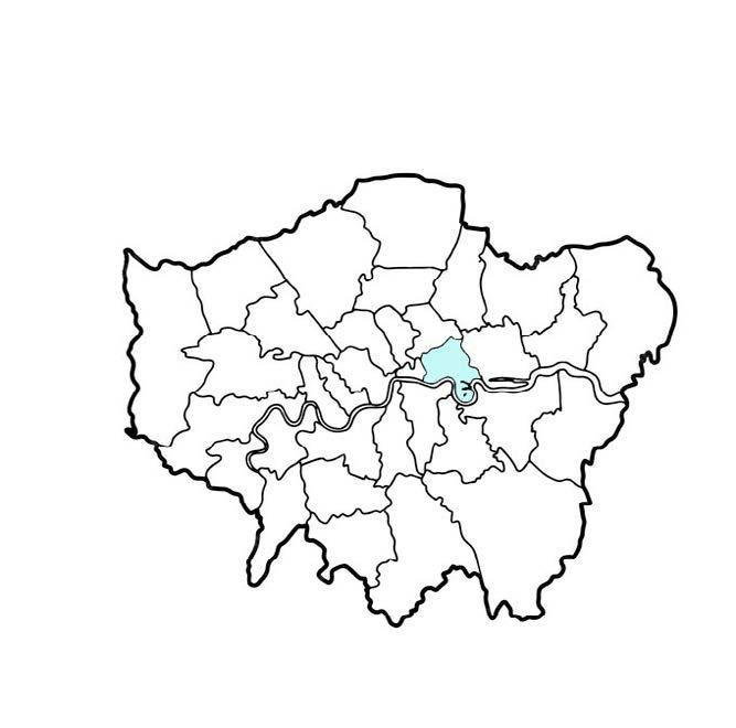
BPLN0056 Urban Design: Density & Form
Flexible South Poplar
Connectivity | Circularity | Culture

SHANTHALAKSHMI SRIDHAR • CELINE KARIZA SALIM • ROSA HOWARTH KENNEDY • JAMIE DAWES
Tower Hamlets is one of the fastest growing boroughs in the coun� try, requiring significant housing provision to meet its current and pro jected demand. The borough is also the site of stark inequalities, both in economic outcomes and urban morphology. Likewise in the South Poplar site. Poplar, to the North, is the ninth most deprived ward in the borough and is characterised by low rise social housing. To the South lies Canary Wharf, the fourth least deprived ward, boasting high rise luxury towers. In the context of these challenges and the wider issues of sustainability and economic recovery, the regeneration of South Poplar holds the key to revitalising the dormant Billingsgate area
To face the uncertainty of population change, economic change, and climate change, we propose flexibility as the key design solution. Through this, we will enhance South Poplar’s connectivity, circularity, and culture, futureproofing urban development and providing the foundation for the region to prosper.
Opportunities and Constraints


02. URBAN TISSUE ANALYSIS - LANDUSE, BUILDING HEIGHTS, BUILDING TYPOLOGY
BUILDING HEIGHTS
There is a clear division between the different land uses found in Canary Wharf (predominantly offices) and in South Poplar, containing mostly residential buildings with other uses including edu cational and retail.
Apart from the Billingsgate Fish Mar ket, Poplar Business Park and New City College, the site is predominantly residential. The site lacks a defined central landmark which all residents and users can use daily. The new masterplan therefore must create an urban environment which encourages vibrancy and social interaction through greater, more useful mixed uses such as sus tainable community spaces, parks, re tail, cultural spaces and so forth. Doing so will help to re-connect South Poplar and Canary Wharf.


The site sits in between two highly contrasting areas in terms of building heights. The site and South Poplar are characterised by low-rise residential buildings made up of 2-6 storeys with an open skyline. To the south of the site, Canary Wharf consists of high-rise office buildings upwards of 25 storeys which dominate the skyline and engulf surrounding areas.
The Tower Hamlets High Density and Tall Build ings SPD (2021) suggests that high-rises can offer optimal solutions for high densities and efficient use of land. However, as explored in this report, the majority of the green spaces found in the area are underutilised and overall there is a clear lack of cohesion between the urban en vironments of South Poplar and Canary Wharf. Furthermore, the larger carbon footprint of tall buildings due to carbon intensive materials and general maintenance results in buildings that are less sustainable and incoherent with surrounding low rise buidlings.
BUILDING TYPOLOGIES


The residential building typologies in the area largely consist of row, ribbon, and solitaires along with irregular courtyards and groups. Due to the pre existing street network and flat topography, the typologies are set within a more irregular, stand alone pattern. The nature of the typologies creates more private green spaces with buildings set back from the street network.
Due to the sites industrial history, the layout and choice of typologies appears to be divergent and uncoordi nated, limiting the potential the built environment offers to its residents. As a result of a more seperated urban fabric, public space become more anonymous dis couraging ownership and care over green spaces inbetween typologies which are used as fillers, rather than open space with a defined purpose.
The newly built typologies in the area largely consist of high-rise solitaires echoing the urban fabric found to the South in Canary Wharf. However, the solitaires re spond poorly to the historic low-rise urban fabric. The towers tend to be isolated and dominate the space.


Due to the nature of chosen residen tial typologies such as rows and rib bons, there is a high level of private and semi-public green spaces with in the area. As a result, the area is vis ually green, from private gardens to semi landscaped curbside greenery. However, these spaces are largely insular - offering little to no social interactions across the area, heightening the feeling of disconnectedness with Canary Wharf
Within the area, there are several public parks including Stoneyard Lane Gardens, and semi public areas such as Leyland House Community Garden, within less than 5 minute walk between each space. Spaces such as the community garden offer a more meaningful space for connections to be made and encourage ‘eyes on the street’ (Jacobs, 1961). Yet, these spaces can feel constricted and are limited in the variety of uses they offer, resulting in users shortening the amount of time they spend within these green spaces.


The ‘tributary’ street system (Marshall, 2005) formed by Aspen Way through South Poplar, shows the curilinear, T-tree layout with numerous cul-de-sacs looking out towards Billingsgate. This system reflects Poplar’s historically lower-density layout, yet limits efficient movement and accessibility towards the proposed site.
Focusing on the cul de sacs which off shoot from Poplar High Street, there is a lack of permeability and perceived connectedness towards Billingsgate and Canary Wharf. This negatively impacts residents and visitors liveability a factor which is vital to the longevity of an area.
In contrast, the grid pattern consisting of crossroads and continuity of cross routes (Marshall, 2005) fosters high connectivity and accessbility. Throughout the area, there is a clear lack of footpaths, further isolating connectivity, limiting social interactions and limiting the amount of carfree areas.


With the site being located inbetween Canary Wharf and South Poplar, there is variety of well-connected public transport nodes available. There are over 20+ bus stops and 7 DLR and Elizabeth Line stations within a 15-minute walk from Billingsate.
The accessibility results in a Public Transport Accessibility (PTAL) rating between 3-5, which is deemed as a good score. This also helps support the car-free approach found in the London Plan (2021).
However, the lack of connectivity be tween the North and South of the site, pedestrian footpaths and vehicle-centric domination of the overall area limits the site’s potential in being a well-connected, sustainable and car-free urban environment, made more apparent by factors such as Aspen Way which are crucial ac cess roads yet hinder the area’s liveabil ity. This imbalance also affects personal safety, reduces varied green spaces and discourages sustainable approaches.


Pedestrian Footpaths
Private Green Space


KEY TAKEAWAYS
UNEQUAL TENURE DISTRIBUTION
Poplar exhibits a much higher proportion of social rented accommodation compared to Canary Wharf which is more weighted towards private rental units. It is important that our design provides suitable levels of affordable housing and ensures a diverse mix of tenure across the development.
DIVERSE HOUSING NEEDS
Both wards indicate a diverse mix of ethnicities, with the proportion of White British in both wards lower than in London overall. Canary Wharf tends to attract a more transient population of young professionals while Poplar follows a pattern of larg er household sizes and multi generational living. However, it will be important to build-in flexibility in our design solutions, for example through modular housing where unit allocation can be adapted de pending on demand.
NEED FOR IMPROVED ECONOMIC OPPORTUNITIES AND AMENITIES
Canary Wharf demonstrates a predominance of managerial and professional jobs, whereas the so cio economic distribution in Poplar is more varied. This indicates a need for a variety of job opportuni ties and economic sectors beyond the office-based employment in Canary Wharf. Overall, boosting the circular economy could help to alleviate long term unemployment, which is highest in Poplar at around 20%.
CONNECTIVITY CIRCULARITY CULTURE PLANNING TARGETS
Improve connectivity via public transport and ac tive modes of travel
Design for longevity, ad aptability and resilience.
Futureproof buildings.
Embody ciruclar econo my principles throughout the design process.
Enhance local context through design.
Produce safe, secure and inclusive environments.
Respect elements of her itage, architecture and cultural value.
Address the physical bar riers and poor connectivi ty created by Aspen Way with new and improved walking and cycling routes (4.1.e)
Development will be of exemplary quality and capable of accommo dating densities to sup port sustainable places (4).
Create a positive sense of place with public squares and green openspace that integrates north south links and Poplar DLR Station A (4.1.j)
Public realm, including streets, should be designed to prioritise pedestrian movement and, when ap propriate, cyclists.
Support high quality, inter connected places with im proved transport networks.
Development should fa cilitate the transition to the circular economy and zero carbon goals. Design should support the sharing economy to decrease costs and resource consumptions while encouraging social in teraction.
Streets should assist inte gration of residents with neighbours and buildings with their urban context.
Development should ease navigation and cre ate attractive, welcom ing spaces.
Integrate development into the green grid, con nect to Poplar High Street, and resolve severance caused by Trafalgar Way.
Manage development intensification and asso ciated impacts on the environment and existing communities.
Deliver new and im proved open and water spaces, which are acces sible and well integrated into new development.
Conenct to and en hance green and open space.
Development should positively enhance the local environment and economy.
Create healthy and livea ble neighbourhoods.
Support Canary Wharf’s redesignation as a met ropolitan cetnre with a diverse mix of leisure and employment uses.
HOUSING
South Poplar is a designated London Opportunity area and is thus a major target for housing delivery:
31,209
homes delivered between Isle of Dogs and South Pop lar by 2031
3,000
homes delivered in South Poplar (7% of target area size) with 45% affordable homes
The Tower Hamlets housing target is 58,965 homes by 2031. 31,209 (57%) of these are allocated in South Poplar and the Isle of Dogs.
ENHANCING
LIVING AT DENSITY
A key objective is to optimise density while improving the public realm and overall quality of life. Policy D3 emphasises the need for a design led approach for achieving suitable densities. A design led approach is critical for setting a site vision, determining capacity and ensuring appropriate development for the specif ic social, economic, and environmental context.
06. OPPORTUNITIES AND CHALLENGES
SITE CHALLENGES
SITE OPPORTUNITIES


BUILDINGS
The social housing to the north of the site must be retained to ensure current residents are not relocated, social housing stock is retained and local historic character is kept. The introverted typologies must cohe sively merge with the site, while improving the overall liveability and vi brancy of the existing residential area. The sprawl of premium high-rises and business-centric area from Canary Wharf will need to be controlled to ensure Billingsgate is an accessible area for all, and to not create another spatial divide between the two sites.
CONNECTIVITY AND ACCESSIBILITY
The rail depot, DLR lines and Aspen Way dual carriageway will con tinue to create a physical barrier between Canary Wharf and South Poplar. Not only does the barrier limit physical accessibility, create a socio-economic divide due to decreased footfall and perceived divide; the urban fabric ceases to cohesively intertwine to create a con nected urban fabric. Tower Hamlets exceeds the WHO 2005 limit of 10 ug/m3, while neighbouring major roads to the site including Aspen Way exceed the UK annual limit (25ug/m3) of PM 2.5 (Tower Hamlets Air Quality Action Plan 2022 27). These figures further highlight the socio-economic divide, risks to public health, and the over-reliance on private vehicles over public transport.
OPEN SPACE
The open spaces found within the area are predominantly homogenous in terms of their uses and private ownership. As the site has been increasingly developed based on piecemeal (rather than a comprehensive plan), a disconnected and unproductive network of open spaces has emerged.


Bridges / underpass across Aspen Way
New / enhanced connections
New canal pedestrain route
BUILDINGS
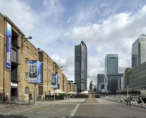
The site offers a large amount of space where unqiue typologies can be developed to offer high-density, affordable, flexible and sustainable housing to help meet the Borough and London’s overall housing target. The site carries rich histor ic cultural significance for the city of London. Being able to retain and refurbish historic buildings including Billingsgate Fish Market and the Accumulator Tower will retain and improve the site’s cultural connections to other areas of interest, including London Museum Docklands.
CONNECTIVITY AND ACCESSIBILITY
Implementing new bridges and improving the underpass across Aspen Way will help to improve walking times and overall experience to the public transport net work. Improving the overall walkability of the site through improved foot and cycle paths, open spaces away from main roads and ground and decked levels will create different oppourtunities for the diverse population.
OPEN SPACE
To create a more inclusive public open space network that provides a diverse range of productive uses, from community gardens/allotments, skills sharing spaces, SUDs, nature areas to natural shading will allow residents and users to take natural ownership of these spaces, and encourage more organic, mean ingful interactions and overall vibrancy of the space. Furthermore, natural assests such as the canal and Poplar High Street will help to connect the new network with the pre existing spaces. Implementing a green buffer along Aspen Way will not only help to mitigate emissions, noise and sound pollution, but will create a space for other interventions, such as accessible bridges and skateparks that provide more inclusivity for older and younger generations.

Aspen Way Dual Carrigeway
VISION AND DESIGN PRINCIPLES
1. CONNECTION
We will improve north south and east west connections by linking pedestrian and cycle corridors, creating permeable walkways, and enhancing public transport options. Safety, inclu sivity, and accessibility will be prioritized through better lighting, seating, noise reduction and functioned design.
2. CIRCULARITY
The existing green network will be expanded with a mixed use green buffer along Aspen Way, east west connections through Wharfinger, im proved canal route, varied open space network throughout the site and improving the public realm on both ground and podium levels.
In line with Canary Wharf evolving from an exclu sive business district to a mixed use destination, we will enhance the flexible circularity of the site. Strategies will include utlising flexible building techniques such as pre fabricated housing, de signing for disassembly to suit future requirements of the urban fabric, accomodations for flexible living such as canal boats, and green infrastruc ture to mitigate climate change (SUDs, waste re duction, energy sharing).
3. CULTURE
We will develop the urban fabric to encour age social interactions, vibrancy, ‘eyes on the street’ privacy and safety through diverse uses, typologies and connectivity. The revitalized Bil lingsgate Market will re house previous stallhold ers, host workshops, pop ups, and food festivals, celebrating the area’s heritage and sustaina ble practices. Installations inspired by the area’s maritime and trade heritage will be incorporate into public areas while engaging with residents and visitors.


CONNECTIONS
Relocating the DLR depot and replacing the area with modular residential court yard, slab and L shaped block typologies will help to integrate with the historic urban fabric.
Refurbishment of Billingsgate Fish Market and redevelopment of under utilised surrounding area through mixed use tower, podium and courtyard typologies will create higher densities and vibrant spaces.
Green buffer along Aspen Way will counter air and noise pollution, while expand ing the overall green network across both ground and podium levels.
Shared routes will either be fully pedestrianised or have limited vehicular access. The bridges and underpass will encourage sustainable active travel, while reduc ing commuter times and making the site more accessible with ramps.
Through the promotion of flexible living, modular buildings and amentities fos tering the circular economy will mitigate climate change by fostering positive, sustainable change on a personal and community level.

Aspen Way
Seperating the north and south sections
Main shared routes provid ing greater connectivity
Pedestrian Bridges Connecting north south barrier Bus stops and train stations Poplar High Street
Linking the Masterplan back to the vision:

1.Circularity
Character Areas:
Circularity in the South Poplar Masterplan focuses on resource efficiency , environmental sustainability , and social equity . Modularity in tower construction of units reduces material waste and enables adaptable spaces, while rooftop gardens and rainwater harvesting systems minimize runoff and maximize reuse . Retail frontages support small businesses and foster a circular economy, and the retention of social housing units ensures long term affordability and equitable access, promoting social sustainability. The masterplan also has a business park , boosting local economy and shared resources ultimately supporting economic growth.
2. Connectivity

Bridging Canary Wharf and Poplar, two pedestrian bridges with ramps over Aspen Way enhance accessibility and inclusivity. Public plazas, squares, spillover spaces, and transit links foster movement, interaction, and vibrant activity nodes across the site.
3. Culture
This is embodied through the preservation of the North Quay wall as a promenade and the celebration of the accumulator tower with a heritage boulevard in Billingsgate Terraces. Culture thrives in spaces like Poplar Plaza with an indoor sports center fostering community interaction, the Billingsgate retrofitted market blending tradition with local entrepreneurship, and a vibrant skatepark encouraging creative expression and activity.

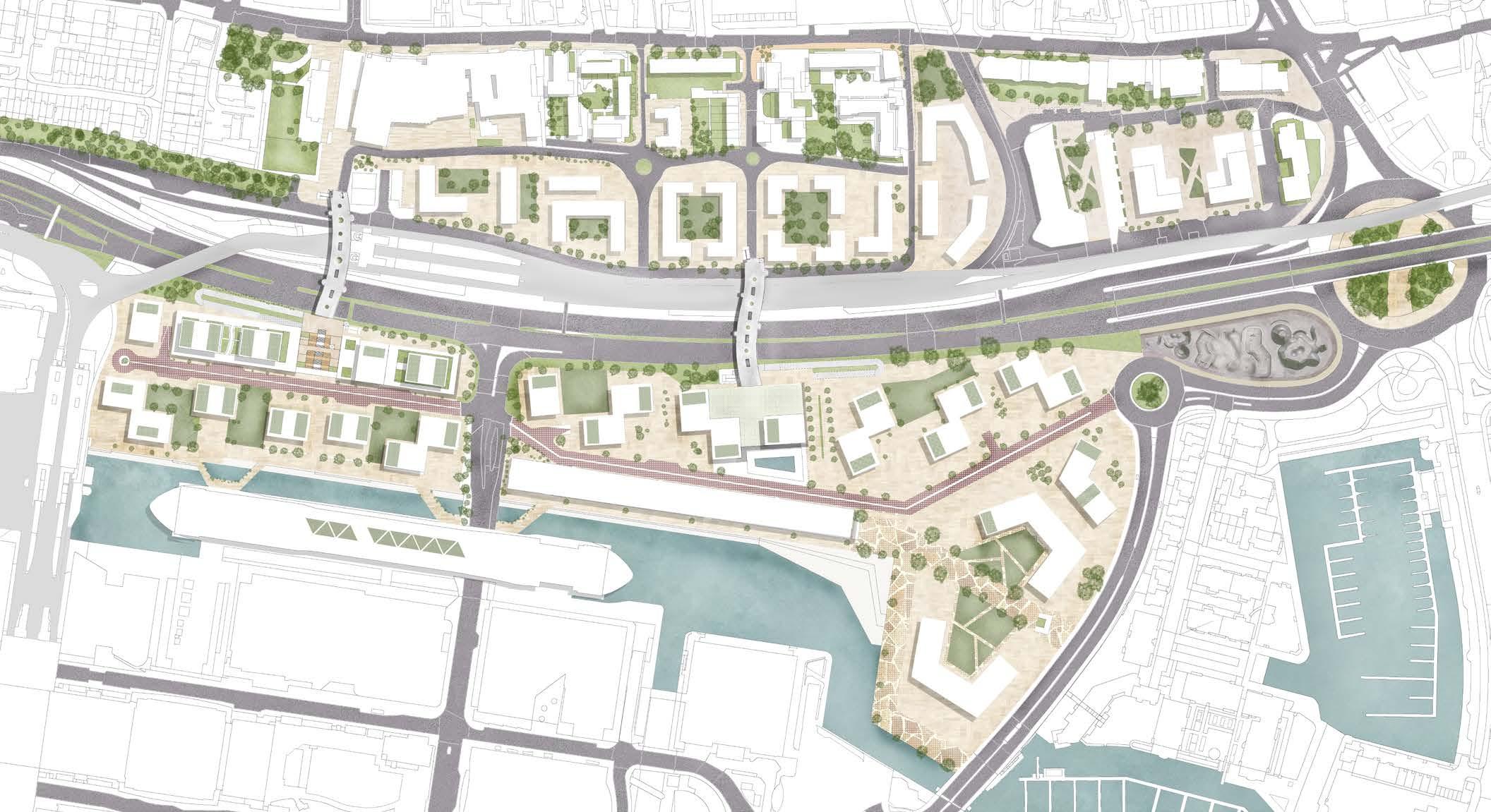
The axonometric masterplan diagram embodies the core vision of Circularity, Connectivity, and Culture, aligning with the ambitions of the South Poplar Opportunity Area. It presents a strategic north-south and east-west framework that unifies the divided landscapes of Poplar and Canary Wharf into a cohesive and sustainable urban ecosystem.
Circularity is central to the design, with resource-efficient modular typologies, rooftop rainwater systems, and social housing retention ensuring environmental and social sustainability. The inclusion of retail frontages and a business park fosters a circular economy by creating local economic opportunities and support ing sustainable practices. These elements combine to establish a self-sustaining, adaptable urban environment.
The east-west connections, including the skate park, heritage boulevard, floating deck, quay-side promenade, squares, and the existing Poplar High Street, activate the site through continuous, interactive thoroughfares. These spaces celebrate cultural heritage while encouraging economic activity and social interaction.
The north-south links, realized through two pedestrian bridges and curved ramps over Aspen Way, prioritize inclusivity and accessibility, physically and sym bolically bridging communities. This integrated network strengthens ties within the site and extends its benefits to the broader context, fostering active cultural exchange and connectivity.
By intertwining sustainable practices, vibrant public spaces, and a robust movement network, the masterplan achieves its vision of a circular, connected, and culturally rich environment while addressing the strategic objectives of the opportunity area.


Multifunctional
Sports hub
Sustainable community hub
Poplar Depot Lane (Modular Housing)
Business Park
Modularity
We utilise policy D3 of the London Plan with regards to modular and circular design: building in layers to ensure that different parts of the building are accessible and can be maintained and replaced as required, designing out waste, designing for longevity, and designing for flexibility, disassembly and reuse.

Quay Square Rain Garden
Wharfinger Courts and Billingsgate Terraces (Modular Housing)
Redeveloped Billingsgate Market
Dockland Heights (Modular Housing)
Modularity allows ease of reconfiguration and flexible usage. It supports evolving demands and strengthens adaptability in the face of population change, economic change, and climate change. Designing for flexibility reduces obsolescence and increases efficiency, while promoting social integration.

et al., 2015)
CASE STUDY
MODULAR HIGH RISE, 101 GEORGE STREET, CROYDON


(PRP Architects, 2014)
Completed as the world’s tallest modular tower in 2019, construction took just 35 weeks. This shows how modular construction methods can be used to develop high density projects, with pre-assembled components significantly reducing construction time and associated emissions.
Blue-green infrastructure Circular economy

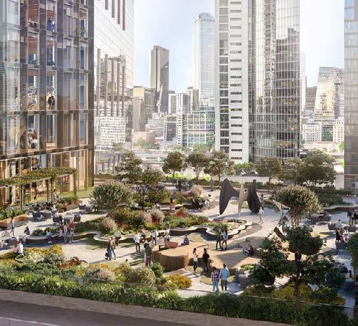
Following policy D3 and the South Poplar Masterplan, we propose to integrate Poplar with Canary Wharf through a network of blue and green spaces. Developing green infrastructure brings the combined benefits of optimising site capacity, enhancing safety, and encouraging healthier lifestyles (GLA, 2023). Additionally, well designed green infrastructure helps reduce flood risk, urban heat and air pollution, while improving placemaking and wellbeing.
We provide dedicated green spaces such as parks alongside street trees, SuDS, and rooftop gardens. Green spaces will be multifunctional, such as the rooftop terraces which provide rainwater collection, solar power generation, composting and urban farming opportunities. The sustainable community hub will be a focal point for social integration and environmental innovation. Meanwhile, the facilities hub and leisure centre provide flexible solutions for visitors and encourages usage of the canal network. The resulting interconnected ecological mosaic will enhance nature, leisure, and quality of life.
By designing in flexibility from the outset, buildings, products and materials can continue to provide high value return beyond their initial purpose (Williams, 2021). Construction, demolition and excavation waste account for 48% of all waste in London (GLA, 2011). Addressing the construction waste stream is predicted to generate economic growth of £3bn £5bn annually by 2036 and 600 jobs by 2030 (Mitchell, 2015).
This South Poplar development will help London’s transition into a circular city (LWARB, 2017). Our circular strategy encourages the organic growth of business innovation. By providing flexible mixed-use space and active frontages, such as in Poplar Plaza and Billingsgate market, we facilitate the formation of small start-up companies and the scaling up of innovations in the circular economy. Through this we show the importance of embodying circularity throughout the built environment; from circular economy to circular city (Williams, 2021).

(Flannigan, 2021)
(Wallance
(GLA, 2021)
11. REIMAGINING CONNECTIVITY
PEDESTRIAN AND CYCLE ROUTES
Upon investigation from our field visits, we found that many of the roads leading off Poplar High Street looking towards Canary Wharf, including Simpson’s Road and Harrow Lane, appeared to be cut short and limited North South connectiv ity. Similarly, there was no clear, accessible route across the site from West India Quay DLR station to Trafalgar Way limiting the East-West connection.
The improved and brand new pedestrian and cycle bridges to the West and Centre of the site across Aspen Way will free up North-South movement with the addition of the improved pedestrian underpass under Aspen Way to the East. Ramps will provide an accessible route for cyclists, wheelchair users and buggies. The northern part of the site will be opened up through a tripartite grid layout (Marshall, 2015) through shared streets, along with designated pedestrian-only access. These routes will provide better connections beyond the site, including routes leading off Poplar High Street. Billingsgate Business Park to the northeast will retain the circular route to preserve commercial and domestic access. The ‘Wharfinger Courts’ area will include the central shared route (Billingsgate High Street), along with routes through the green buffer and along the canal, improving the east-west connection from North Dock to Blackwall Basin.
LINK TO D3 POLICY
In relation to the D3 policy, the improved cycle and pedestrian network will facil itate active travel, by creating convenient, inclusive cycle and pedestrian routes which reduce active travel times to public transport nodes and local amenities by approximately 2-5 minutes. There will be on-street and indoor cycle parking, a facilities hub to help with cycle repairs, legible crossings and entrances which are ‘aligned with peoples’ movements and desire lines in the area’ (The London Plan, 2021).
DLR LINE & VEHICULAR ROUTES


With the focus shifted from vehicle dominance to active travel as the primary mode of travel, vehicle movement will remain through the main roads, such as Aspen Way, South Poplar High Street and Trafal gar Way, while adding a new main road (Poplar Depot Street) to help improve overall access for families and other residents. Keeping the vehicular traffic seperate from the main pedestrian movements will improve pedestrian and cyclist safety and ensure active travel times are kept reduced.
Other shared roads including Billingsgate High Street and Poplar Plaza which run centrally through Wharfinger Courts will only permit vehicular access during certain time periods. All vehicles will not be able to access these roads from 8am - 6pm, apart from blue badge holders and permit holders. Underground carparks, loading bays and acces sible on street parking spaces will help to ensure vehicular congestion is minimised throughout the day.
LINK TO D3 POLICY
Vehicles only being permitted to enter roads in Wharfinger during cer tain times will help to prevent crossover with pedestrians and cyclists during peak hours, while encouraging active travel. Underground car parks and on street parking zones will help to free up space and reduce the dominance of vehicles. Creating more space for pedestrian access will encourage ‘community interaction and economic vitality’ (The London Plan, 2021).
Accessible
Pedestrian access
BRIDGE OVER ASPEN WAY AND GREEN BUFFER
Refill Shop

FoodCycle Hub
Community Garden


PROPOSED LAND USE ON PODIUM LEVEL (1ST FLOOR)
The proposed land uses will help to merge the residential area of South Poplar (now known as Poplar Depot) and the corporate area of Canary Wharf to cre ate a more balanced area with mixed uses from community hubs, cafes, leisure centres to retail and office spaces. Billingsgate High Street and Poplar Plaza will become new vibrant high streets, with mixed uses along the ground and podi um levels to activate the spaces during day and night. Having a vibrant centre will not only increase the liveability of the area, but will benefit other factors such as active travel. With a variety of transport nodes, predominant land uses and high population and housing density has been shown to increase public trans port usage thus promoting the circular economy of the site.


(residential use from 2nd floor above)
In line with the circular economy hierachy for building approaches, we have de veloped more sustainable and productive land uses. One of these approaches includes the facilities and community hubs which will include amenities such as a bike repair workshop, refill/zero-waste shop, a recycling hub, renewable energy power source centre, FoodCycle hub (to source edible surplus food from community gardens, local shops and restaurants), community kitchen, and oth er available spaces that the local community could use. For example, the local community garden would be able to share produce they have grown in the FoodCycle hub, which the local community could use to create seasonal menus to not only educate the community when and how to grow seasonal produce, but as an oppourtunity to share recipes from their cultures.
Additionally, there will be other facilities provided for more flexible living. These will include public toilets, showers, water points and sewage disposal, focused on users who may be living more flexibly such as those living on canal boats using nearby mooring areas at North Dock. These proposed land uses further expand the policy’s requirements for changing uses, as it reflects London’s temporal, flexible population who are adapting to chang es, such as high living costs, in more creative ways. By ensuring the urban environment creates a ‘welcoming and inclusive neighbourhood’ the lo cal community will experience broader benefits, ‘such as access to shared amenity space and high-quality public realm’ (The London Plan, 2021).
(Darwen Town Center, 2020)
(Levitt Bernstein, 2021)
(Research Gate, AOI Land scape Design, 2021)


KEY PLAN


The proposed cut off angles are ranging between 20 and 64 degrees, with most staying within the Tall Buildings SPD guide line of an ideal 45 degrees. This proposal demonstrates a thoughtful balance between achieving an optimum denisty and complying to design principles and standards that ensure compability with surrounding contexts. The angles exceeding the standard remain consistent in provid ing a good urban design, providing a con siderably wide shared surface or public realm for the general public to enjoy the outdoors.
In strategic areas, increased angles al low for greater density while also improving urban quality. The angular variations strengthen the identity of the masterplan, offering a gradual skyline from the existing residentials along the Poplar High Street to the towers at Canary Wharf.
According to the Tall Buildings SPD (2021), it emphasises a 45 degree angular plane as a transition to lower scale buildings to reduce overshadowing and to present a cohesive urban fabric. By main taining most angles under 45 degrees, the proposal offers smooth transition to the existing buildings, mitigating visual dominance and creating harmonious continuity.
The adherence to lower angles also im proves the spatial quality of open spaces within the site, aligning with the emphasis on integrating green infraststructure, ensuring the usability of the space
SECTION B-B BILLINGSGATE TERRACE
SECTION C-C GRADUAL SKYLINE TOWARDS CANARY WHARF
286,761 m2 SITE AREA

0 35 homes

DOCKLAND HEIGHTS
TYPOLOGY MIX
TOWER : 1797 (72%)
COURTYARD : 596 (24%) SLAB : 118 (4%)
The proposed development in South Poplar near Canary Wharf integrates a strategic typology mix to balance density and livability. Towers dominate with 72% (1,797 units), optimizing vertical density for the urban skyline. Courtyard typolo gies (24%, 596 units) offer community-focused living with open spaces, while slab typologies (4%, 118 units) provide efficient use of linear spaces.
This mix ensures a variety of housing typologies that cater to different lifestyles and preferences, balancing high-density living with quality public realm and open spaces. The distribution reflects a thoughtful urban design approach, maximizing density in tower forms while integrating mid-rise and linear typologies to create a harmonious and sustainable urban fabric in South Poplar.
STUDIO : 46 (1.83%)
1 BED : 956 (38%)
2 BED : 1171 (46.6%)
3 BED : 339 (13.4%)
The proposed unit mix in South Poplar near Canary Wharf bal ances urban density with diverse housing needs. With a focus on one- and two-bedroom units (84.6%) to cater to professionals and small families, it also includes studios (2%) for transient residents and three bedroom units (13.4%) to support longterm family living.
This mix promotes a socio-economic balance, aligning with the area’s urban and demographic demands while fostering a vibrant and sustainable community.
COURTS
The proposed development offers a total of 3,097 homes, including the retention of 585 existing units, reflecting a commitment to main taining housing continuity while addressing future needs. Of these 45% are allocated as affordable housing (1393 homes). 33% of total homes are for private rental (681 homes) and 22% of total homes are for private ownership ensuring a mix of tenures that caters to various income levels and promote socio-economic integration.
The project achieves a ground coverage of only 26%, leaving 74% as open space, which emphasizes on public realm quality, environmen tal sustainability and residents’ well-being. This arrangement supports a population of 9,904 while maintaining a balance between built form and green infrastructure. The floor area ratio of 4.69 indicates an efficient use of land, achieving high density without comprimising on open space or community amenities.
Dockland Heights and Wharfinger Courts are high-density developments providing 947 and 850 homes, respectively, due to their proximity to Canary Wharf and key transport links like the Elizabeth Line and Poplar DLR. They support the largest populations, 3,149 and 2,896. Billingsgate Terraces features the lowest plot coverage, reflecting its extensive open green space, yet achieves a high overall FAR of 8.3, enabling the provision of 366 homes. This demonstrates an effective balance between preserving green infrastructure and maximizing development potential. Meanwhile, Poplar Depot Lane, with a plot coverage of 10,968 m², is a lower-density development despite its proximity to Dockland Heights. This distinction is influenced by its location within Poplar and the retention of existing units, emphasizing the integration of new developments with the site’s established urban fabric
UNIT MIX
OVERALL CHARACTER MAP


OVERALL TYPOLOGY MAP

Courts
Dockland Heights Billingsgate Terraces Poplar Depot Lane


STOREYS: From 26 storeys being the highest, and 10 storeys being the lowest, the building heights in Dockkland Heights and Wharfinger Courts aligns with the high rise solitaires found in Canary Wharf. (southern edge of the site). This typology provides the most dwelling density (1797 homes).
ARRANGEMENT: The buildings are posi tioned to create a dynamic skyline of varying heights to offset the bulkiness of the towers on the Canary Wharf side and offer street level access from all sides, fostering interaction with the public realm and retail frontage. This arrangement enhances connectivity to nearby transport hubs such as the Elizabeth line and Poplar DLR station.
Two podium typologies are placed central ly in both the character areas, which form a central active zone fostering movement across the site.


STOREYS: From 11 storeys being the highest and 5 storeys being the lowest throughout the pro posed areas of Poplar Depot Lane (low-rise) and Billingsgate Terraces (Mid-rise), respecting the surrounding configurations of both Poplar and Canary Wharf respectively. This typology pro vides intermediary dwelling density (596 homes).
ARRANGEMENT: The conventional courtyards are laid out in Poplar, with its main entrance ori ented away from Aspen Way, offering a private, neighbourhood friendly area for residents
The cascading courtyards in Billingsgate Terraces, feature ground-floor retail. The staggered floors offer better day light and ventilation to the units and prevents over-shadowing to the adjacent buildings. The form of the courtyard also frames the heritage building in the area, blending it into the new fabric instead of isolating the heritage.


STOREYS: From 6 storeys being the highest and 4 storeys being the lowest throughout the proposed areas of Poplar Depot Lane, respecting the low rise configuration of Poplar (northern edge of the site). This ty pology provides least dwelling density (119 homes).
ARRANGEMENT: The L-shape Slab is po sitioned in a way to frame semi-private green spaces whereas the linear slab block accommodates pocket parks surrounding the building. The access points are deliberately oriented away from the road to enhance privacy. The slabs complement the surrounding context, echoing the existing slab-style building typologies in the area.


Modular units can be linked using standardized connections for struc tural support, utilities, and shared walls, allowing seamless integration of core modules like living spaces, bedrooms, kitchens, and bathrooms. This flexible system enables creation of diverse layouts while reducing waste and optimizing construction efficiency. (Steelconstruction.info, 2015)
Future adaptability and circularity can be achieved by designing modules for easy disassembly, reuse, or reconfiguration, supporting evolving needs and sustainable practices.
DOCKLAND HEIGHTS AND WHARFINGER COURTS


LANE


This visualization depicts the pro posed podium to be reserved for both residents and visitors. It is a mixed-use function with restaurant spill over spaces on either sides combined with retail spaces, allowing the visitors to engage with an environment that differes from a typical retail level mall or street. The podium can be accessed from the proposed pedestrian bridges pres ent in Dockland heights and Wharfinger Courts.

LINKED TOWER TOWER WITH


The provision of dual aspect dwellings enables better sunlight penetration and allows for cross ventila tion (Mayor of London, 2023). The indicative layout of the tower typologies illustrates one of many unit mix floor plans where dual aspect layouts are dominant for all 2 bedroom and 3 bedroom units, ensur ing proper day light and cross ventialtion.
Although, most 1 bed units are single aspect dwellings, the habitable rooms are placed across the external facade receiving adequate daylight and ventialtion.


The semi-private green rooftop, featuring landscaped gardens and seating areas, serves as an ideal community gathering space for residents. Designed to include urban farms, the rooftop fosters local food production and encourage community participation through gardening activities/educational programs, promoting sustainable living practices. They also con tribute to biodiversity, reduce urban heat, energy production through solar panels and support the circularity goals of the masterplan by utilizing composted organic waste and rainwater harvesting systems for irrigation.


PODIUM
SECTION AA
CONVENTIONAL COURTYARD


The courtyard typology has an advantage of having an enclosed public realm which could be used for commu nity gathering and playgrounds for children, providing safety and security.
Since the area is surrounded by the property itself, it has the advantage of “eyes on the street” as a natural surveillance from the residents. The area will also be com plemented by street furniture that improve safety and leg ibility such as street lighting.

The shared greenspace, fea turing landscaped gardens and seating areas, serves as a communal space for resi dents or even the larger pub lic. Complemented by local stores that also acts as ac tive frontages, the proposed area will be more lively and vibrant.
They also contribute to biodiversity, reduce urban heat, and support the circularity goals of the masterplan by utilizing composted organic waste and rain garden system for stormwater runoff treatment.


CASCADING COURTYARD


Residential Retail Green space


The provision of dual aspect dwellings ena bles better sunlight penetration and allows for cross ventilation (Mayor of London, 2023). The indicative layout of the conventional courtyard typology has a dominant dual aspect ratio for all the corner units and those with single aspect ratio, have their habitable rooms placed across the external facade receiving plenty of daylight and ventilation.
In contrast, cascading courtyards primarily feature single-aspect units but leverage their terraced form to reduce overshadowing and enhance sunlight and airflow. Habitable rooms along external façades ensure sufficient day light and ventilation, demonstrating how innovative massing can optimize environmental performance in dense urban settings.


L slab has the benefit of hav ing sides to create bound aries, enclosing the greenspace and providing more privacy. The development incorporates retail on the ground floor , offering servic es such as healthcare , convenience stores, cafe and restaurants for both the residents and general public. This distribution of functions makes the overall space more legible to different groups of the community.


Neighbouring buildings and boundaries created by sur face difference creates places in this area such as landscaped garden, green buffer, active frontages and other shared surface. They are complemented by seat ings, pathways and lightings to support local business es on the ground floor and generate more outdoor ac tivities.

Although most units are single aspect dwellings, by optimizing the habitable room placements across the external facade, aid them in receiving adequate daylight and ventilation
Surrounding slab buildings also have green pocket parks which enhance the microclimate, improving the air quality and provide visual relief. The proposal can also benefit from innovative facade solutions such as brise-soleil or larger window openings that can improve natural light and ventilation.
Slab typologies, despite its limitations in offering single aspect dwellings, was still considered beneficial to include in our design proposal as they maximize the use of limited land in south poplar, enabling high density development while maintaining a relatively compact footprint. They aslo help us in achieving our main objective of modular construction, as the layouts are repetitive, allowing for streamlined construction processes and reduced costs.

The sections depict a slight cascading skyline positioned in a way to have a human-scale approach, since the distance between buildings are rather limited. The retail at ground level are strategically positioned only in a few of the buildings to create more privacy since this area focused more on family-oriented homes. However, the interactive active frontage still offers a vibrant hub that foster social interactions and outdoor activities. The proposed shared surface complements the active frontage well, and can be used as a place for outdoor and communal gatherings, promoting inclusivity and a shared purpose among the residents.
19. CHARACTER AREA | DOCKLAND HEIGHTS


Dockland Heights redefines the southern edge of South Poplar with scaled cluster of modular towers, ranging from 26 to 10 storeys, near the Elizabeth Line and Poplar DLR. Aligning with Tower Hamlets’ 2031 vision for Canary Wharf as a metropolitan hub and guided by Policy D3, the proposal situates residential towers within a well-connected urban framework of jobs, services, and transit, while respecting the site’s form and character.
Embedding the vision of connectivity and culture, the proposal boasts a pedestrian bridge and a curved ramp linking South Poplar to a grand public plaza with seating and an indoor multifunctional centre underneath. This plaza is connected to a mixed-use podium featuring retail , local food and beverages businessess activating economy. The vibrant ground-level realm, enhanced by garden squares and a quayside promenade, invites seamless movement between South Poplar and Canary Wharf. By bridging divides, fos tering public activity, and contributing to the circular economy, Dockland Heights transforms this area into a bustling, accessible, and inclusive urban destination.
Delivery in relation to our key concept objectives:
Circularity
Modular construction contributing to flexible and sustainable construction.
Connectivity
Pedestrian Bridge connection to podium for north to south connection.
Communal space creation of South poplar plaza.

HOUSING DISTRIBUTION
The tower achieves 696 dph, prioritizing smaller, work-oriented units through vertical, compact design. The linked tower has a lower density of 587dph, emphasizing on family friendly 2 and 3 bed units. The tower with podium, at 753 dph, everages space for shared amenities and offers balanced unit mix, showcasing how form can influence both spatial efficiency and demographic inclusivity.
According to the GLA Housing and Land report (2021), the average Londoner inhabits approximately 33m2 of floorspace per person. Based on this estimation, a 1-bed unit can house up to 2 people,while a 2 Bed can house up to 4 people and 3-Bed up to 5 people. The unit mix reflects socio-economic segmentation 1 bed units and a portion of 2 bed units are designed for the private rental market, meeting the demands of working professionals and smaller households. Meanwhile, 3 bed units , prominently situated in towers with waterfront views, cater to affluent families and are targeted for private ownership, enhancing the market appeal and financial viability of the development.
Rain gardens, blue and green roof systems encompassing drain age.
Quay Side Promenade for east to west connec tion.
Community meet up spaces in quay and garden squares.
and podium levels.
Shared road (pedestri an and vehicular) east west connection.
Green
Rooftop Garden

The pedestrain bridge accessible from the active side of South Poplar closer to the college is linked to the Poplar plaza integrated to the mixed use podium. The footfall is then invited to explore the quay side squares con nected to the waterfront promenade, fostering a vibrant public realm for both its visitors and general public.
Due to the proximity to multiple public tranportation links ( Poplar DLR and Elizabeth line at crossrail), dockland heights is dominated by public space for the general public to enjoy. Nevertheless, the landscaped roof top gardens are semi-private catering to the building residents within the property.
Cultivation of Circular economy on the ground
Podium.
20. URBAN DESIGN FEATURES - PEDESTRIAN BRIDGE ‘A’ AND ASPEN RAMP | DOCKLAND HEIGHTS


The Aspen Horizon Pedestrian Bridge and Aspen Twist Ramp are central to our design proposal, aligning with our connectivity and cultural objectives.
By replacing the inefficient existing bridge near the DLR station, we aim to create an accessible, green thoroughfare with a ramp that links the North and South while serving as a natural noise buffer along the site boundary
The bridge also integrates seamlessly with a central public realm feature, the Poplar Plaza, enhancing connectivity and fostering community engagement.
FEATURES OF ASPEN HORIZON


The Aspen Twist ramp directly connects to both the mixed-use podium base of the tower and the central grand staircase with seating buffers, called the Poplar Plaza. The ramp link provides an accessible passage for pedestrians and cyclists but also enhances the user experience by offering picturesque views while crossing over the busy thoroughfare. [ slope ratio used in the design is 1: 10 for ease of wheelchair movement.]
CASE STUDY


This design creates a new public landscaped domain over a vehicular road at the height of 7.9m. This linear park like bridge is where peo ple can slow down their pace, are invited to sit down and admire different flora, interact deeply with the community.

The seating spaces cultivate an educational plant nursery environment encour aging visitors to linger and engage, transforming what would otherwise be a busy thoroughfare between Poplar and Canary Wharf into a purposeful and inviting destination.


The Aspen Twist Ramp finds a compelling precedent which demonstrates the multifunctionality of a curved ramp connected to a footbridge, effec tively serving as a noise buffer between the road and the adjacent school
This example highlights how such infrastructure can blend functionality, accessibility, and aesthetic appeal, addressing both practical and experiential needs.

The Aspen Horizon Pedestrian Bridge draws inspi ration from Seoullo 7017, which demonstrates the potential of elevated infrastructure to serve as a live urban garden and social space while spanning over a busy roadway
Similarly, the proposed bridge connects Poplar and Canary Wharf, linking seamlessly to the mixed use podium with public access to retail The proposed Circular rain-attenuated garden planters with integrated seating foster communal interactions and create a vibrant, green thoroughfare.
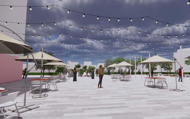
21. URBAN DESIGN FEATURES - POPLAR PLAZA AND QUAY SQUARE | DOCKLAND HEIGHTS
POPLAR PLAZA
Poplar Plaza is designed as an interactive stepped plaza with integrated seating, seamlessly connected to the Aspen Horizon pedestrian bridge and the mixed-use podium.
This landscaped space serves as a landmark within the Dockland Heights located at a height of 7.9m, offering direct links to the podium’s spill-out areas for retail and commercial units. It is carefully designed to address the level change from the footbridge to the site, with lifts incorporated to ensure universal accessibility. The space underneath the plaza is designed as a multi-functional sports centre which has indoor gym , basketball and tennis courts for residents and membership only access for the public (visitors)

POPLAR PLAZA - PERSPECTIVE


The indicative section illustrates the relationship between the pedestrian bridge, integrated seating areas, and the podium. Beyond serv ing as a public realm landmark, it demonstrates how the space beneath the Poplar Plaza has been efficiently utilized for an indoor sports center, rather than remaining unused. This circular design approach maximizes the site’s potential, ensuring both functional and spatial efficiency, reiterating the ‘circularity, connectivity and culture’ objective of the proposed masterplan.
Quay Square is proposed to be enveloped by active ground floor frontages with spill out spaces into the public realm creating a lively atmosphere. This is proposed to be a flexible space for cultivating community gatherings, performances, outdoor cinemas and cultural stalls with a child-friendly focus. The square is also designed to maintain a visual connection between Poplar Plaza and the Elizabeth line at crossrail.


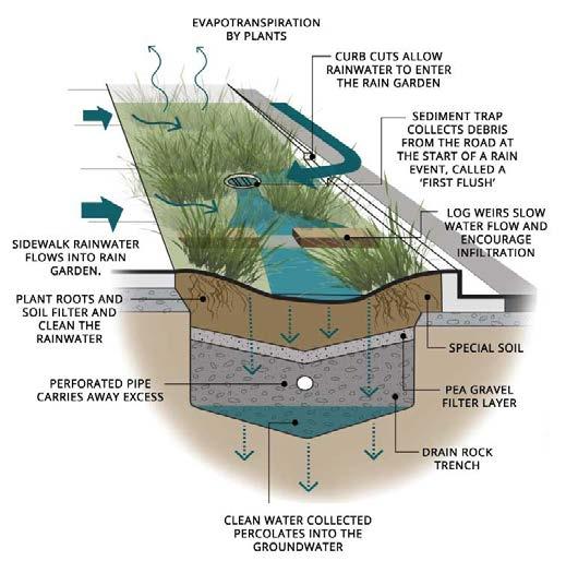
Rain gardens are integrated into the square to capture stormwater runoff (https://www.courtenay.ca, 2019), helping to reduce drainage into the existing north dock and promote sustainable water management.
The rain gardens have been designed to capture water drainage and cut down on the need for irrigation. (Virgin Islands Resource Conservation and Development Council, Inc., n.d.)
The indicative diagram on the left illustrates how a successful rain garden can be implemented on site.

The indicative section illustrates a quality public open space with a stong interaction of all the active frontages (retail front, seating near the water, promenade and quay square). The pro vision of these squares enhances the liveability of the proposed high density development by fostering social interaction, improving accessibility to all functions, supporting sustainability, and promoting health and well-being. It complements our optimal density of the site by improving the quality of life
POPLAR PLAZA - PLAN
POPLAR PLAZA - SECTION
QUAY SQUARE - SECTION
View from the
22. WHARFINGER COURTS - OVERVIEW, TYPOLOGY MIX, HOUSING MIX, GREEN AND OPEN SPACE


Wharfinger Courts, located on the quieter southern edge of the site, features a cluster of modular residential towers ranging from 24 to 12 storeys. The development integrates a well-distributed public realm, with multiple squares, a pe destrian bridge, a mixed use podium, and sports amenities such as a skate park and sports courts.
A boulevard, accessible via a pedestrian ramp, connects the area to Billingsgate Market. Being further removed from major transportation hubs compared to Dockland Heights, Wharfinger Courts fosters a more neighborhood-friendly environment, prioritizing community engagement and local amenities over direct transit connectivity.


Linked towers, comprising 75% of the development, offer a higher den sity configuration at 242 dph, reflecting the demand for affordable, family-sized housing. The tower with podium at 161 dph, combine residential units with mixed-use areas, optimizing land use while accommodating diverse socio-economic groups. Singular towers cater to more exclusive, lower density market, providing space for residents seeking privacy.
Delivery in relation to our key concept objectives:
Circularity
Modular construction contributing to flexible and sustainable construction.
Connectivity
Pedestrian Bridge connection to podium for north to south connection.
Communal space creation of landscaped plazas and skate park

More on the quieter side, the unit mix caters more towards smaller households and working professionals offering more 1 bed units and a portion of 2 bed units for affordable private rental market, whereas, the lesser ratio of 3 bed units are targeted for private ownership captalizing the property’s advanta geous views towards the waterfront and lanscaped plazas.
Rain gardens, blue and green roof systems encompassing drain age.
Direct access to Billingsgate market from the bridge and podium area.
Community meet up spaces in spill over areas on the squares.
Cultivation of Circular economy on the ground and podium levels.
road
an and vehicular) east west connection.
The pedestrian bridge accessible from the quieter side of South Poplar is linked directly to the mixed-use podium featuring botique shops, cafes, creche centres etc. The visitors are also greeted with direct access to the billingsgate market, ground level retail frontages and sport related activities such as the Skate Park and sports courts.
The area is dominated by public space offering recreational activities to the general public to foster more movement and bridge the divide between Poplar and canary wharf. Nevertheless, the green rooftop amenities being semi-private cater to the building residents within the property.
HOUSING DISTRIBUTION
Shared
(pedestri
Cultural integration of Mixed-use Podium.
23. URBAN DESIGN FEATURES - PEDESTRIAN BRIDGE B AND PODIUM LINK, SKATE PARK | WHARFINGER COURTS
Aspen Horizon ‘B’ at Wharfinger Courts is similar to Aspen Horizon ‘A’ in Dock land Heights, but it is directly connected to the mixed-use podium rather than a landscaped plaza. This design choice channels foot traffic more effectively towards specific mixed-use functions such as a creche centre, billingsgate market and skate park, cre ating a more controlled and purposeful flow.


The boulevard serves as a key navigation route for pedestrians, guiding them to the Billingsgate Market and the skate park Its design facilitates easy movement, enhancing connectivity between key destinations while contributing to the overall flow of pedestrian traffic in the area.

The spill over spaces activate the ground plane through social interaction, relaxation and community activities, that support mixed-use functions like retail and dining.

The Bridge directly connects to the mixed-use podium link which houses cafes, food and beverages along with a creche centre as Wharfinger Courts in comparison to Dockland Heights is more neighbourhood friendly, resulting in a relatively quieter and family-oriented community. The footfall is then invited to visit the billingsgate market and Billingsgate terraces located towards the south of the site. The podium link also provides a clear access to the skatepark located at the eastern edge of the site.

The proposed skatepark over Trafalgar Way aims to accommodate younger generations and to unify an otherwise isolated piece of land along Aspen Way, drawing foot traffic to an active space that can absorb noise. The design of the skatepark, with its varied level changes, not only enhances its functionality but also helps mitigate sound, creating a dynamic yet quieter environment.
A successful mixed use podium was implemented in Australia, motivated by the concept of togetherness joint ownership and open space for local residents and the wider community
The podium and its rooftop are reserved for public use, and within the podium, a market place, retail and entertainment spaces are housed. This stems our inspiration for propos ing a multifunctional podium, enhancing connection between Poplar and Canary Wharf.

This is a well informed precedent showcasing a working practical solution of a skatepark positioned below a major motorway. The skatepark is also dotted along the edges with trees to minimize sound and pollution.
Despite Aspen Way’s increasing height to the north, a similar approach could effectively mitigate environmental impacts and improve the skatepark’s functionality.
CASE STUDY : BARÓ DE VIVER SPORTS URBAN PARK, BARCELONA, SPAIN
CASE STUDY : STH BNK BY BEULAH, MELBOURNE, AUSTRALIA, 2018
ASPEN WAY
ASPEN
HORIZON B ASPEN TWIST RAMP B
BILLINGSGATE MARKET
ASPEN TWIST BOULEVARD
TYPOLOGY MIX

Billingsgate Terrace is located at the southeast of the site, enjoying the privilege of having The Quay Promenade right in front of the area. It also has a continuous square leading from the Billingsgate market to Heritage Boulevard, where the Accumulator building is now given its own prominence. This continuous route offers exceptional exposure of cultural heritage to the users.
This area accommodates 3 main buildings, with the form of cascading courtyards and half-courtyards, each providing an enclosed semi-public garden . Its close proximity to the North Dock would increase its value in terms of visual ex perience, giving the residents unobstructed view to canary wharf and along the north dock. It also provides a high end community neighbourhood experience situated near the waterfront.
AERIAL VIEW STREET SECTION


of area’s typologies
Cascading Courtyards, comprising 100% of the development, offers a high density configuration of 210 dph, reflecting the demand for high end, family sized housing, capitalizing on good views and the nearby heritage asset to the area. Two out of three of the buildings are also complemented by active frontages, creating a lively and vibrant neighbourhood, inviting the larger public to enjoy the area.
Delivery in relation to our key concept objectives:
Circularity
Modular construction contributing to flexible and sustainable construction.
Connectivity
Clear footway route from promenade to the residential properties.
Culture
A continuous footway from the billingsgate market to hertiage boulevard invigorating cultural exchange.

HOUSING DISTRIBUTION
Designed in alignment with TfL’s Pedestrian Comfort Guid ance, ensuring safe and seam less movement for all users.
Since Billingsgate Terrace is situated closer to Canary Wharf and exposed to busier and more crowded area, the housing distribution prioritises working professionals and small families with mainly 2-bedroom unit type, which hous es 328 and 664 occupants respectively. However, we also propose nearly 10% of the development for larger families to support mix of demography.
roof systems encompassing drain age.
Direct access to
deck plaza.
Retrofitting the billingsgate market into a lively culture hub.
GREEN AND OPEN SPACES
Cultivation of Circular economy on the ground level.
Shared road (pedestri an and vehicular) east west connection.
Community meet up spaces in heritage boulevard and greenspace.
The Quay Promenade is directly accessible from Billingsgate Terrace, mak ing it the main open space for outdoor activity, fostering social interaction both between the residents and general public. The central square con nects the promenade to the Accumulator building, adding cultural value to the property that is currently facing access challenges

Due to the proximity to The Quay Promenade, the billingsgate terrace is dominated by public space, providing greenspace for the general public to enjoy the promenade. Nevertheless, the courtyard form would provide the residents semi public greenspaces within the property.
Cascading Courtyard
The redevelopment along the North Dock introduces a spacious, active promenade that would nurture social inter actions and outdoor activities. The promenade integrates seamlessly with wetlands to create a harmonious blend be tween natural environment and urban elements. This combination would establish The Quay Promenade as a vibrant and ecologically sensitive space, fostering both social and environmental awareness.


Improved connection is one of the core concept of the development, therefore connection from Dockland Heights and Wharfinger Courts are also improved by extended decks to promote accessiblity to the Elizabeth Line Station. In addition to that, the design also repurpose the Billingsgate Market to accommodate a more modern and dynamic culture and social hub. The market will be complemented by entrances that connects people from the shared space road to the inside of the market and to the promenade. The Billingsgate Market will combine permanent and pop up themed markets to invite diverse visitors.
To help preserve local culture, the market stallholders will be given space in the newly refurbished market. The facade of the market will also be opened up to create a ‘colonnade’ , creating connectedness between the market and the promenade.
Imp rovedconnection to ElizabetLineStati o n New entrances of th e BillingsgateMarket TheQuay Promenade


Poplar Depot Lane is located to the north of Aspen Way. Due to its close proximity to existing proper ties along the Poplar High Street, the proposed ty pologies refer back to the existing, which are dom inated by ow rise courtyard, slabs and L-slabs.
This area focused on small family and family-oriented homes, up to 3 bedroom units to acommodate 6 persons in one unit. The residents could also benefit from shared private gardens enclosed by the buildings that suits the need of family with children. To provide privacy, only 4 of the buildings have retail ground floors, 2 on the west ern side and 2 other on the eastern side. The local amen ities encouraged to be developed are, but not limited to healthcare facility, grocery shops, and restaurants.
Delivery in relation to our key concept objectives:
Circularity
Modular construction contributing to flexible and sustainable construction.
Connectivity
Pedestrian Bridge connection from Wharfinger Courts to im prove north south connection
Culture
A family friendly neighbour hood , focusing on green and open spaces for outdoor ac tivities
Green roof systems encompassing drain age.
Introducing new vehicular access from west east, connecting to Poplar High Street
Tenure composition en suring mixed demogra phy to improve cohe siveness
Cultural integration
SECTION


HOUSING DISTRIBUTION
Designed in alignment with TfL’s Pedestrian Comfort Guid ance, ensuring safe and seam less movement for all users.
The open spaces in Poplar Depot Lane are more secluded and has a pri vate feeling, focusing on the innercourts of courtyard typology and in be tween building spaces. These openspaces could benefit from residents sur veillance, increasing safety and security in the area.
Courtyard typology, comprising 61% of the development, offer a high er density configuration at 404 dph, reflecting the demand for affordable, family-sized housing. The slab typology at 23%, offers a balanced hous ing types, accommodating diverse demographic groups. L Slab buildings also offers a balanced housing types, catering to working professionals and families.
From the table, we conclude that the housing distribution is small family and family oriented housings, with the total of 346 homes and estimated 1188 oc cupants. It also has a nice combination of studio and 1 bedroom properties, encouraging mixed demography in the area.
Poplar Depot Lane development will benefit from the introduction of new con nections between Poplar High Street and Wharfinger Courts, giving the resi dents access to local amenities on the shared podium.
Cultivation of Circular economy on the ground levels.
Continuous route from the Pedestrian Connection bridge to Poplar High Street


View near the entrance/exit of the Aspen Twist Ramp.
Street view of the square from the southern part of the site
Dynamic Skyline View from the Mixed Use Podium
Sky top View from the human eye level
In conclusion, our proposal demonstrates a clear understanding and reflection of the current critical debates relating typology to optimal density. Through the lens of flexibility, our proposed urban design solutions provide remedies for pressing issues including population growth and climate change, by fo cusing on connectivity, circularity, and culture to create resilient and vibrant neighbourhood (Ng,2009).


FLEXIBLE SOUTH POPLAR THROUGH CIRCULARITY, CONNECTIVITY AND CULTURE
Combining modular design, blue green infrastructure, and circular economy initiatives, we show that sustainable urbanism does not rely merely on the circular economy but on initiatives through out the urban design process, realising the concept of the circular city (Williams, 2021). Facilities including indoor sports centre, FoodCycle Hub, community garden and productive, varied public spaces foster sustainable living.
The 585 existing homes are retained to avoid displacement. Through analysing the D3 policy and housing standards, we ensure proposed homes comply with building codes. For the public realm, we refer to the Transport for London’s pedestrian comfort guidance and design standard. Con sidering connectivity, we introduce new shared surface roads to prioritise pedestrian mobility and encourage active travels.
The local culture is celebrated by preserving existing properties, including retrofitting Billingsgate Market and the listed Accumulator tower. Improving accessibility and public realm quality is high lighted through the inclusion of Quay Promenade, heritage boulevard, Aspen Horizon bridges and mixed use podiums. The communal kitchen, FoodCycle hubs and sports hub can also act as places for gathering, fostering social interactions and strengthening community bonds, while promoting inclusivity and a sense of shared purpose among residents.


BEFORE DEVELOPMENT AFTER DEVELOPMENT
URBAN DESIGN PROPOSAL
PROPOSED HOMES
Our design achieves optimal, intermediate density by seamlessly integrating the high and low densities of Canary Wharf and Poplar. The proposal features 26% ground coverage and 74% open space, prioritising public realm quality. Drawing on practical precedents, our public realm design has been optimized to improve density without compromising liveability.
The selection of typologies plays a pivotal role in this balance. 72% of the site fea tures modular residential towers, extensively incorporating podiums and terraces. This modular system promotes flexibility, enabling diverse layouts and optimizing construction efficiency. Towers with podiums balance high rise living with activat ed lower level spaces, efficiently utilizing land while creating a density gradient from Canary Wharf to Poplar. 24% of the site features courtyard typologies. The other 4% includes slab typologies, ideal for areas transitioning between high and low density zones. These mid rise forms integrate seamlessly into the urban fabric, offering enhanced daylight, ventilation, and open spaces. Together, these ele ments create a harmonious balance between density, liveability, and connec tivity.
LIMITATIONS
Lastly, it is also important to acknowledge the absence of direct community en gagement with the residents. It means the design might not directly reflect the need and aspirations of those most affected. The structural challenges of con structing a large bridge over Aspen Way also require further technical exploration to ensure safety and feasibility, including in the process of construction. Addition ally, the integration of a modular system, particularly in the tower typology, being a relatively new method, requires more time to study to ensure its effectiveness.
REFERENCES
ArchDaily. (2018). Baró de Viver Sports Urban Park / SCOB . [online] Available at: https://www.archdaily.com/897318/baro -de-viver-sports-urban-park-scob [Accessed 29 Dec. 2024].
ArchDaily. (2020). Gallery of Footbridge of Chang’an Experimental Primary School / Zhutao Architecture Design Studio - 18. [online] Available at: https://www.archdaily.com/967880/footbridge -of-changan-experimental-primary-school-zhutao -architecture-design-studio/613169d0f91c8186e300006b-footbridge-of-changan-experimental-pr imary-school-zhutao-architecture-design-studio-photo?next_project=no [Accessed 29 Dec. 2024].
ArchDaily. (2018). Baró de Viver Sports Urban Park / SCOB . [online] Available at: https://www.archdaily.com/897318/baro -de-viver-sports-urban-park-scob [Accessed 29 Dec. 2024].
Digimap (2024). [online] wayf.ukfederation.org.uk. Available at: https://digimap.edina.ac.uk/roam/map/verisk [Accessed 9 Nov. 2024].
LB Tower Hamlets (2020). High density living. [online] Let’s Talk Tower Hamlets. Available at: https://talk. towerhamlets.gov.uk/highdensity [Accessed 12 Jan. 2023].
LB Tower Hamlets (2020). Local Plan. [online] www.towerhamlets.gov.uk. Available at: https://www.tow erhamlets.gov.uk/lgnl/planning_and_building_control/planning_policy_guidance/Local_plan/local_ plan.aspx.
LB Tower Hamlets (2021). South Poplar Masterplan SPD | Let’s Talk Tower Hamlets. [online] talk.towerham lets.gov.uk. Available at: https://talk.towerhamlets.gov.uk/southpoplar.
LB Tower Hamlets (2021). Tall Buildings SPD. [online] Let’s Talk Tower Hamlets. Available at: https://talk. towerhamlets.gov.uk/tallbuildings [Accessed 5 Jan. 2025].
LB Tower Hamlets (2022). London Borough of Tower Hamlets Air Quality Action Plan. [online] Available at: https://democracy.towerhamlets.gov.uk/documents/s207950/6.3a%20Appendix%20One%20for%20 Air%20Quality%20Action%20Plan%202022 2027.pdf.
Flannigan, S. (2021). The Beginner’s Guide to the Circular Economy. [online] blog.sendle.com. Available at: https://blog.sendle.com/guide to circular economy.
ArchDaily. (2018). Baró de Viver Sports Urban Park / SCOB . [online] Available at: https://www.archdaily.com/897318/baro -de-viver-sports-urban-park-scob [Accessed 29 Dec. 2024].
GLA Housing and Land (2021). Housing in London 2021 . [online] London.gov.UK . Greater London Authority. Available at: https://www.london.gov.uk/sites/default/files/housing_in_london_2021_v2.pdf [Accessed 24 Oct. 2024].
ArchDaily. (2020). Gallery of Footbridge of Chang’an Experimental Primary School / Zhutao Architecture Design Studio - 18. [online] Available at: https://www.archdaily.com/967880/footbridge -of-changan-experimental-primary-school-zhutao -architecture-design-studio/613169d0f91c8186e300006b-footbridge-of-changan-experimental-pr imary-school-zhutao-architecture-design-studio-photo?next_project=no [Accessed 29 Dec. 2024].
LB Tower Hamlets (2014). Area profiles. [online] Towerhamlets.gov.uk. Available at: https://www.tower hamlets.gov.uk/lgnl/community_and_living/borough_statistics/Area_profiles.aspx.
London Plan (2021). The Spatial Development Strategy for Greater London . [online] https://www.london.gov.uk/ , p.441. Available at: https://www.london.gov.uk/sites/default/files/the_london_plan_2021.pdf [Accessed 7 Nov. 2024].
Digimap (2024). [online] wayf.ukfederation.org.uk. Available at: https://digimap.edina.ac.uk/roam/map/verisk [Accessed 9 Nov. 2024].
https://www.courtenay.ca. (2019). 5th Street Rain Gardens. [online] Available at: https://www.courtenay.ca/EN/main/community/downtown -revitalization/5th-street-complete-st reet/5th-street-rain-garden.html
ArchDaily. (2020). Gallery of Footbridge of Chang’an Experimental Primary School / Zhutao Architecture Design Studio - 18. [online] Available at: https://www.archdaily.com/967880/footbridge -of-changan-experimental-primary-school-zhutao -architecture-design-studio/613169d0f91c8186e300006b-footbridge-of-changan-experimental-pr imary-school-zhutao-architecture-design-studio-photo?next_project=no [Accessed 29 Dec. 2024].
GLA (Greater London Authority) (2011) in Williams, J. (2021). Circular cities: a revolution in urban sus tainability. Abingdon, a GLA (Greater London Authority) (2021). The London Plan 2021. [online] London City Hall. Available at: https://www.london.gov.uk/programmes strategies/planning/london plan/lon don plan 2021 [Accessed 5 Jan. 2025]. Oxon: Routledge.
GLA Housing and Land (2021). Housing in London 2021 . [online] London.gov.UK . Greater London Authority. Available at: https://www.london.gov.uk/sites/default/files/housing_in_london_2021_v2.pdf [Accessed 24 Oct. 2024].
Levittbernstein.co.uk. (2021). London Festival of Architecture 2021 Levitt Bernstein . [online] Available at: https://www.levittbernstein.co.uk/now/london -festival-of-architecture-2021/ [Accessed 5 Jan. 2025].
Digimap (2024). [online] wayf.ukfederation.org.uk. Available at: https://digimap.edina.ac.uk/roam/map/verisk [Accessed 9 Nov. 2024].
https://www.courtenay.ca. (2019). 5th Street Rain Gardens. [online] Available at: https://www.courtenay.ca/EN/main/community/downtown -revitalization/5th-street-complete-st reet/5th-street-rain-garden.html
GLA Housing and Land (2021). Housing in London 2021 . [online] London.gov.UK . Greater London Authority. Available at: https://www.london.gov.uk/sites/default/files/housing_in_london_2021_v2.pdf [Accessed 24 Oct. 2024].
Local Plan, 2031 (2020). Tower Hamlets Plan 2031 Managing Growth and Sharing Benefits Tower Hamlets Local Plan 2031 Managing Growth and Sharing the Benefits . [online] pp.12–14. Available at: https://www.towerhamlets.gov.uk/Documents/Planning -and-building-control/Strategic-Planning /Local-Plan/TH_Local_Plan_2031_accessibility_checked.pdf [Accessed 20 Oct. 2024].
Levittbernstein.co.uk. (2021). London Festival of Architecture 2021 Levitt Bernstein . [online] Available at: https://www.levittbernstein.co.uk/now/london -festival-of-architecture-2021/ [Accessed 5 Jan. 2025].
GLA (Greater London Authority) (2023). Optimising Site Capacity: A Design led Approach LPG. [online] London City Hall. Available at: https://www.london.gov.uk/programmes strategies/planning/implement ing london plan/london plan guidance/optimising site capacity design led approach lpg [Accessed 6 Jan. 2025].
London Borough of Tower Hamlets Air Quality Action Plan. (2022). Available at: https://democracy.towerhamlets.gov.uk/documents/s207950/6.3a%20Appendix%20One%20for %20Air%20Quality%20Action%20Plan%202022 -2027.pdf [Accessed 6 Jan. 2025].
Jacobs, J. (1961). The Death and Life of Great American Cities. [online] New York: Vintage Books. Avail able at: https://www.petkovstudio.com/bg/wp content/uploads/2017/03/The Death and Life of Great American Cities_Jane Jacobs Complete book.pdf.
https://www.courtenay.ca. (2019). 5th Street Rain Gardens. [online] Available at: https://www.courtenay.ca/EN/main/community/downtown -revitalization/5th-street-complete-st reet/5th-street-rain-garden.html.
Local Plan, 2031 (2020). Tower Hamlets Plan 2031 Managing Growth and Sharing Benefits Tower Hamlets Local Plan 2031 Managing Growth and Sharing the Benefits . [online] pp.12–14. Available at: https://www.towerhamlets.gov.uk/Documents/Planning -and-building-control/Strategic-Planning /Local-Plan/TH_Local_Plan_2031_accessibility_checked.pdf [Accessed 20 Oct. 2024].
Levittbernstein.co.uk. (2021). London Festival of Architecture 2021 Levitt Bernstein . [online] Available at: https://www.levittbernstein.co.uk/now/london -festival-of-architecture-2021/ [Accessed 5 Jan. 2025].
London Borough of Tower Hamlets Air Quality Action Plan. (2022). Available at: https://democracy.towerhamlets.gov.uk/documents/s207950/6.3a%20Appendix%20One%20for %20Air%20Quality%20Action%20Plan%202022 -2027.pdf [Accessed 6 Jan. 2025].
Local Plan, 2031 (2020). Tower Hamlets Plan 2031 Managing Growth and Sharing Benefits Tower Hamlets Local Plan 2031 Managing Growth and Sharing the Benefits . [online] pp.12–14. Available at:
https://www.towerhamlets.gov.uk/Documents/Planning -and-building-control/Strategic-Planning /Local-Plan/TH_Local_Plan_2031_accessibility_checked.pdf [Accessed 20 Oct. 2024].
London Borough of Tower Hamlets Air Quality Action Plan. (2022). Available at: https://democracy.towerhamlets.gov.uk/documents/s207950/6.3a%20Appendix%20One%20for
London Plan (2021). The Spatial Development Strategy for Greater London . [online] https://www.london.gov.uk/ , p.441. Available at: https://www.london.gov.uk/sites/default/files/the_london_plan_2021.pdf [Accessed 7 Nov. 2024].
LWARB (London Waste and Recycling Board) (2017). London’s circular economy route map, Re port published by LWARB.
Marshall, S. (2005). Streets and Patterns. [online] 2 Park Square, Milton Park, Abingdon, Oxon OX14 4RN: Taylor & Francis e -Library. Available at: https://www.taylorfrancis.com/books/mono/10.4324/9780203589397/streets -patterns-stephen-m arshall?refId=fd6cff1c-15c8-40fe-8349-2ad857df3231&context=ubx [Accessed 8 Nov. 2024].
London Plan (2021). The Spatial Development Strategy for Greater London . [online] https://www.london.gov.uk/ , p.441. Available at: https://www.london.gov.uk/sites/default/files/the_london_plan_2021.pdf [Accessed 7 Nov. 2024].
Newby, J. (2020). A visit to Darwen’s eco refill shop, Earth Evolution… | Darwen Town Centre [online] Darwen Town Centre. Available at: https://darwentowncentre.co.uk/2020/08/16/visit -to-darwens-eco-refill-shop-earth-evolution/ [Accessed 5 Jan. 2025].
Ng, E. (2009). Designing High Density Cities For Social and Environmental Sustainability. Routledge.
Marshall, S. (2005). Streets and Patterns. [online] 2 Park Square, Milton Park, Abingdon, Oxon OX14 4RN: Taylor & Francis e -Library. Available at: https://www.taylorfrancis.com/books/mono/10.4324/9780203589397/streets -patterns-stephen-m arshall?refId=fd6cff1c-15c8-40fe-8349-2ad857df3231&context=ubx [Accessed 8 Nov. 2024].
Newby, J. (2020). A visit to Darwen’s eco refill shop, Earth Evolution… | Darwen Town Centre [online] Darwen Town Centre. Available at: https://darwentowncentre.co.uk/2020/08/16/visit -to-darwens-eco-refill-shop-earth-evolution/ [Accessed 5 Jan. 2025].
Mitchell, P., 2015, Employment and the circular economy—Job creation through re source efficiency in London, published by City Hall, London.
Marshall, S. (2005). Streets and Patterns. [online] 2 Park Square, Milton Park, Abingdon, Oxon OX14 4RN: Taylor & Francis e -Library. Available at: https://www.taylorfrancis.com/books/mono/10.4324/9780203589397/streets -patterns-stephen-m arshall?refId=fd6cff1c-15c8-40fe-8349-2ad857df3231&context=ubx [Accessed 8 Nov. 2024].
Sardeshpande, M., Rupprecht, C. and Russo, A. (2020). Edible urban commons for resilient neighbourhoods in light of the pandemic. Cities, p.103031. doi:https://doi.org/10.1016/j.cities.2020.103031 .
Sardeshpande, M., Rupprecht, C. and Russo, A. (2020). Edible urban commons for resilient neighbourhoods in light of the pandemic. Cities, p.103031. doi:https://doi.org/10.1016/j.cities.2020.103031 .
Newby, J. (2020). A visit to Darwen’s eco refill shop, Earth Evolution… | Darwen Town Centre [online] Darwen Town Centre. Available at: https://darwentowncentre.co.uk/2020/08/16/visit -to-darwens-eco-refill-shop-earth-evolution/ [Accessed 5 Jan. 2025].
Steelconstruction.info. (2015). Modular construction . [online] Available at: https://www.steelconstruction.info/Modular_construction
PRP Architects (2014). GEORGE STREET PLANNING APPLICATION.
Newby, J. (2020). A visit to Darwen’s eco refill shop, Earth Evolution… | Darwen Town Centre [online] Darwen Town Centre. Available at: https://darwentowncentre.co.uk/2020/08/16/visit -to-darwens-eco-refill-shop-earth-evolution/ [Accessed 5 Jan. 2025].
Steelconstruction.info. (2015). Modular construction . [online] Available at: https://www.steelconstruction.info/Modular_construction
Tall Buildings, SPD (2021). Tall Buildings SPD. [online] Lets Talk Tower Hamlets. Available at: https://talk.towerhamlets.gov.uk/tallbuildings [Accessed 24 Oct. 2024].
Sardeshpande, M., Rupprecht, C. and Russo, A. (2020). Edible urban commons for resilient neighbourhoods in light of the pandemic. Cities, p.103031. doi:https://doi.org/10.1016/j.cities.2020.103031
Steelconstruction.info. (2015). Modular construction . [online] Available at: https://www.steelconstruction.info/Modular_construction .
Steelconstruction.info. (2015). Modular construction . [online] Available at: https://www.steelconstruction.info/Modular_construction .
Tower Hamlets Borough Profile (2024a). Tower Hamlets Borough Profile Corporate Strategy and Improvement Team. [online] pp.4–6. Available at: https://www.towerhamlets.gov.uk/Documents/Borough_statistics/Tower -Hamlets-Borough-Profile -2024.pdf [Accessed 20 Oct. 2024].
Tall Buildings, SPD (2021). Tall Buildings SPD. [online] Lets Talk Tower Hamlets. Available at: https://talk.towerhamlets.gov.uk/tallbuildings [Accessed 24 Oct. 2024].
Tower Hamlets Borough Profile (2024b). Tower Hamlets Borough Profile Corporate Strategy and Improvement Team. [online] pp.4–6. Available at: https://www.towerhamlets.gov.uk/Documents/Borough_statistics/Tower -Hamlets-Borough-Profile -2024.pdf [Accessed 20 Oct. 2024].
Tower Hamlets Borough Profile (2024a). Tower Hamlets Borough Profile Corporate Strategy and Improvement Team. [online] pp.4–6. Available at:
Tower Hamlets Borough Profile (2024a). Tower Hamlets Borough Profile Corporate Strategy and Improvement Team. [online] pp.4–6. Available at: https://www.towerhamlets.gov.uk/Documents/Borough_statistics/Tower -Hamlets-Borough-Profile -2024.pdf [Accessed 20 Oct. 2024].
Tower Hamlets Borough Profile (2024b). Tower Hamlets Borough Profile Corporate Strategy and Improvement Team. [online] pp.4–6. Available at: https://www.towerhamlets.gov.uk/Documents/Borough_statistics/Tower -Hamlets-Borough-Profile
https://darwentowncentre.co.uk/2020/08/16/visit
[Accessed 5 Jan. 2025].
30. REFERENCES
Steelconstruction.info. (2015). Modular construction . [online] Available at: https://www.steelconstruction.info/Modular_construction .
Sardeshpande, M., Rupprecht, C. and Russo, A. (2020). Edible urban commons for resilient neighbourhoods in light of the pandemic. Cities, p.103031. doi:https://doi.org/10.1016/j.cities.2020.103031
Tall Buildings, SPD (2021). Tall Buildings SPD. [online] Lets Talk Tower Hamlets. Available at: https://talk.towerhamlets.gov.uk/tallbuildings [Accessed 24 Oct. 2024].
Steelconstruction.info. (2015). Modular construction . [online] Available at: https://www.steelconstruction.info/Modular_construction .
Towerhamlets.gov.uk. (2014). Area profiles. [online] Available at: https://www.towerhamlets.gov.uk/lgnl/ community_and_living/borough_statistics/Area_profiles.aspx.
Tall Buildings, SPD (2021). Tall Buildings SPD. [online] Lets Talk Tower Hamlets. Available at: https://talk.towerhamlets.gov.uk/tallbuildings [Accessed 24 Oct. 2024].
Tower Hamlets Borough Profile (2024a). Tower Hamlets Borough Profile Corporate Strategy and Improvement Team. [online] pp.4–6. Available at: https://www.towerhamlets.gov.uk/Documents/Borough_statistics/Tower -Hamlets-Borough-Profile -2024.pdf [Accessed 20 Oct. 2024].
Tower Hamlets Borough Profile (2024a). Tower Hamlets Borough Profile Corporate Strategy and Improvement Team. [online] pp.4–6. Available at: https://www.towerhamlets.gov.uk/Documents/Borough_statistics/Tower -Hamlets-Borough-Profile -2024.pdf [Accessed 20 Oct. 2024].
Tower Hamlets Borough Profile (2024b). Tower Hamlets Borough Profile Corporate Strategy and Improvement Team. [online] pp.4–6. Available at: https://www.towerhamlets.gov.uk/Documents/Borough_statistics/Tower -Hamlets-Borough-Profile -2024.pdf [Accessed 20 Oct. 2024].
Tower Hamlets Borough Profile (2024b). Tower Hamlets Borough Profile Corporate Strategy and Improvement Team. [online] pp.4–6. Available at: https://www.towerhamlets.gov.uk/Documents/Borough_statistics/Tower -Hamlets-Borough-Profile -2024.pdf [Accessed 20 Oct. 2024].
Transport for London (2019). Pedestrian Comfort Guidance for London.[online] Transport for London. Available at : chrome extension://efaidnbmnnnibpcajpcglclefindmkaj/https://content.tfl.gov.uk/pe destrian comfort guidance technical guide.pdf
Transport for London (2021). Webcat planning tool. [online] Transport for London. Available at: https://tfl.gov.uk/info-for/urban-planning-and-construction/planning-with-webcat/webcat?Type =PTAL&lat=null&lon=null&scenario=Base%20Year&zoomLevel=15&places=Stations%20stops%20a nd%20piers%7CPTAL%20Values [Accessed 8 Nov. 2024].
UNStudio. (n.d.). STH BNK by Beulah . [online] Available at: https://www.unstudio.com/en/page/11738/sth -bnk-by-beulah
Virgin Islands Resource Conservation and Development Council, Inc. (n.d.). What is a Rain Garden? [online] Available at: https://www.ncei.noaa.gov/data/oceans/coris/library/NOAA/CRCP/other/other_crcp_publicati ons/Watershed_USVI/stx_ee_hope_carton_road/130123_AttachmentC_11103.pdf
www.mvrdv.com. (n.d.). MVRDV - Seoullo 7017 Skygarden. [online] Available at: https://www.mvrdv.com/projects/208/seoullo -7017-skygarden.
Wallance, D., Raven, J. and Bacchus, J. (2015). Moving Parts: Modular Architecture in a Flat World. [on line] ResearchGate. Available at: https://www.researchgate.net/publication/312303231_Moving_Parts_ Modular_Architecture_in_a_Flat_World [Accessed 5 Jan. 2025].
Williams, J. (2021). Circular cities: a revolution in urban sustainability. Abingdon, Oxon: Routledge.
Virgin Islands Resource Conservation and Development Council, Inc. (n.d.). What is a Rain Garden? [online] Available at: https://www.ncei.noaa.gov/data/oceans/coris/library/NOAA/CRCP/other/other_crcp_publicati ons/Watershed_USVI/stx_ee_hope_carton_road/130123_AttachmentC_11103.pdf
www.mvrdv.com. (n.d.). MVRDV - Seoullo 7017 Skygarden. [online] Available at: https://www.mvrdv.com/projects/208/seoullo -7017-skygarden
TOTALS:
OVERALL DENSITY DISTRIBUTION SUMMARY


Population was estimated with respect to GLA housing and land report with studio housing 2 persons, 1 bed hous ing 2 persons, 2 bed housing 4 persons and 3 bed housing 5 persons.
Population estimation for the exisiting houses retained was done through this formula:
Population for existing homes = number of homes retained * people per home ( London. avg.) = 585 * 2.5

The Bartlett School of Planning
GROUP WORK
Our work is a joint submission and includes an account of the contributions made by each group member, signed by all of us.
TO BE COMPLETED BY EACH MEMBER OF THE GROUP
We confirm that all the components of this project are the joint work of the authors. The contribution of each was as follows:
STUDENT’S NAME DESCRIPTION OF CONTRIBUTION (inc. research, presentation, etc.) SIGNATURE
The group contributed equally from early discussions to final execution of design vision, strategies and masterplan. My personal contributions were: design development : outlining the masterplan with various strategies in relation to concept was responsible for dockland heights and wharfinger courts character areas, typologies, urban design features, layout and graphics. developed ideas for tower typologies ( tower, linked tower, tower with podium). designed the pedestrian bridge A and B, aspen twist ramp,poplar plaza and quay square, rendering views, and contribution to final presentation. was involved in creating dual aspect dia grams along with the housing distribution and proposed residential demographic and respective calculations. collaborative effort in writing the conclusion.
The group contributed equally from early discussions to final execution of design vision, strategies and masterplan. My personal contributions were: design development :developing the masterplan with uses according to the proposed vision and concepts. I was responsible for the modular category and modular mix proto types, matching the units with the buildings, measuring the area based on standards. was also involved in counting the proposed dwellings and occupants, collaborating continu ously with my groupmates. For the production, was responsible for the South Poplar Depot Lane and Biillingsgate Terrace character areas, along with their urban design features, pro ducing graphics, maps, and narratives. Collaborating for the final conclusion. attended all the meetings both in person and online with all my groupmates and our tutor.
The group contributed equally from early discussions to final execution of design vision, strategies and masterplan. My personal contributions were:

ROSA HOWARTH KENNEDY
JAIME DAWES
I was responsible for the urban tissue analysis of land uses, building heights, typol ogies, natural elements, street hierarchy and public transport network. Similarly for identifying the site opportunities and challenges, concept map, reimagining connec tivity and overall proposed land use. I developed ideas focusing on flexibility, accessi bility, culture, and circularity and how these could be translated into the urban fabric. We collaboratively wrote the conclusion and actively participated in all meetings and discussions with the team and tutor.
The group contributed equally from early discussions to final execution of design vision, strategies and masterplan. My personal contributions were: the initial ex ploration of tower and podium typologies, with thematic research in flexibility and circularity. wrote the introduction and context, urban tissue analysis ( residential demographics and housing tenure), alongside the spatial policy context and reima gining circularity vision page. We worked together on the conclusion and attended all tutorials and group sessions.


TO BE COMPLETED BY THE TUTORS:
Was the work equally shared among all members of the team? YES □ NO
SHANTHA SRIDHAR
CELINE KARIZA
SALIM
JAMIE DAWES