

Glenville Riverfront Park

Executive Summary
Located in Gilmer County, West Virginia, lies the 1-square mile town of Glenville. Glenville was Incorporated in the year 1856 and achieved economic success until the 1930’s with the use of the Little Kanawha River that extends the length the town. Oil was struck nearby in the small town of Letter Gap in 1875, leading to additional economic success. In 1872, Glenville State University (known at this time as Glenville Normal School) was established in Glenville and has steadily grown (1,600 students) and provides additional amenities for the town with the Waco Center, the I.L. Sue Morris Stadium, and the Sue Morris Sports Complex. Most of the amenities hosted in Glenville were generously developed by Ike Morris, the founder of Waco Oil & Gas Company established in the 1960’s. In 1950, the West Virginia State Folk Festival was created by Dr. Patrick Gainer and held in Glenville to preserve the music, crafts, foods, and folklore that are distinct to the Appalachian region.
As the push to reduce mining traditional natural resources in the area, the town of Glenville looked to the river basin that started their economic boom over 150 years for their future economic success. The Glenville Riverfront Park Masterplan poses to create a family friendly whitewater park, lodging, hiking/biking trails, fishing access, commercial businesses, and day-use opportunities in the heart of downtown Glenville. With this masterplan, Glenville will spearhead the system to be known as the Pioneer Trail Towns development along the Little Kanawha River basin creating a vibrant, cohesive, and dynamic linkage through Braxton, Gilmer, Calhoun, Wirt, and Wood Counties as a driver for family-friendly recreation from Burnsville to Parkersburg, West Virginia. Strategically placing lodging amenities and recreational activities of various levels every 10-20 miles along the Little Kanawha River allows users to have multiple experiences (i.e. festivals, hiking/biking trails, shuttle services for river float trips, small-town Appalachian life, restaurants, and many more), providing the ability for extended stays within the region and provide economic development and success to Glenville and the region as a whole.
Glenville, West Virginia Local Attractions
The Sue Morris Sports Complex provides the area with a multitude of active outdoor recreation opportunities. The family-friendly complex includes, three baseball/softball fields (one being NCAA compliant), batting cages, indoor training facility, lighted picnic shelters, covered playground, full-sized basketball court, volleyball court, 1/2-mile walking trail, eight RV camper spaces, community fire pit, and a covered performance stage.

Since 1950, the third Thursday in June, the town of Glenville brings in an estimated two to three thousand visitors to the town to explore what small town life was like over in Glenville over 100 years ago. From traditional music, square-dancing, story telling, and ballad singing to antique vehicles, parades on East Main Street, raffles and contests; you will see Glenville’s vibrant history beam to life once again, showing Glenville’s importance to the region and the state as a whole.

Established in 1872, Glenville State University is a picturesque Appalachian campus offering a close-knit atmosphere and 17 four-year academic programs spanning education, business, sciences, and arts with a modest student body of 1,600 students. The university boast 17 Division two athletic teams in the Mountain East Athletic Conference. Beyond its educational contributions, Glenville State University enriches Glenville and the region by providing cultural events such as art exhibitions and music performances, along with economic opportunities and a skilled workforce.

Regional Connections
Glenville’s close proximity to other major parks, towns, and the Little Kanawha River produces a great opportunity to expand the economic development of the town through lodging, campgrounds, a white water park, and other outdoor recreational opportunities. Only 28 miles Northeast of Glenville near the town of Weston is the Stonewall Resort State Park, a 1,900 acre park with over 82 miles of lake shoreline, lodging, hiking trails and more. Located 16 miles East of Glenville is the town of Burnsville and its major attraction, the Burnsville Lake Wildlife Management Area, a 12,579 acre area with a 968 acre lake and dam where the headwaters of the Little Kanawha River begins. The Burnsville Lake mostly supports Class-Q hunting, fishing, and more than 250 tent and RV campsites. Located 8 miles to the South, lies Cedar Creek State Park, a 2,588 wooded acre park with three small fishing ponds, mini-golf course, 14 miles of hiking trails, and 76 RV campsites.
While many locations surrounding Glenville provide passive outdoor recreation activities, using the Little Kanawha River as a recreational backbone to provide the area with the only white water park would help promote Glenville as a muststay location for those who are seeking more active outdoor recreation activities in addition to hundreds of acres of hiking/ biking trails. With over 275 planned rental opportunities, Glenville could be the centralized location for tourists to stay and venture outward for single-day trips to the surrounding region’s amenities.
Sue Morris Sports Complex
West Virginia State Folk Festival
Glenville State University
Glenville Regional Concept Map

Regional Conceptualization is an important factor of the masterplan, extending the program elements and concepts throughout the region will help promote and guide future connections of the Pioneer Trail Towns system. Connecting the region with clear and cohesive branding (The Pioneer Trail Towns) would provide tourist an additional level of comfort by providing items as listed below.
• Digitized Web-based Maps depicting
• Internet Coverage
• Cellular Coverage
• Trail Systems
• River Launch & Take-out Points
• Shuttle Services for River
• Campgrounds and Lodging
• Local Businesses and Hours of Operation
• Emergency Contacts by Region
• Cohesive Wayfinding Signage and Symbology

Glenville Riverfront Park Masterplan
Glenville Riverfront Park Masterplan has been developed to aid the town of Glenville with economic development strategies and connection to other regional recreation opportunities by promoting the development of the Little Kanawha River and Glenville as a recreational hub. The development of the river corridor and connection to the surrounding region via river, trails, and road access will aid in increased tourism of the area and economic development of the downtown area of Glenville. The proposed uses for this masterplan are to be a white water kayaking park, hiking/biking trails, open park areas, picnic shelters, fishing access, and lodging.
Goals & Objectives
Goal 1: Create Additional Outdoor Recreational Opportunities
• Objective 1a: Analyze existing regional tourist attractions including parks, trails, and geographic points of interests surrounding Glenville, WV.
• Objective 1b: Analyze the connections to other regional points of interests.
Goal 2: Create Extended-Stay Lodging Opportunities
• Objective 2a: Develop various types of lodging including cabins, yurts, and RV camping to provide an option to all financial groups.
• Objective 2b: Development of amenities to increase options for guests including a white water kayaking park, court-based games, hiking/biking trails, and other day-use activities to increase economic development of Glenville.

Arbuckle Riverfront Campground Plan
Overview:
The Arbuckle Riverfront Campground will be accessed via the East Little Kanawha Highway and is the only major development on the eastern side of the river. It is posed to provide the largest RV campground resort on the riverfront which includes many RV resort type amenities. It will provide hiking trails to access downtown Glenville and a pedestrian bridge to access the upstream kayak launch points from either the downtown or Manley Property sites. This Masterplan includes:
Amenities:
• 107 RV Space Campground
• 11 Rental Yurts
• 5 Picnic Shelters
• 2 Play Courts
• Trail Access to Downtown
• Trail Access to West Side of the Little Kanawha River via a Pedestrian Bridge
• 2 Kayak Launch/Takeout Points


Pedestrian Bridge
Rental Yurt
Riverside Trail
RV Campground

Arbuckle Riverfront Campground Plan


Downtown Riverfront Plan
Overview
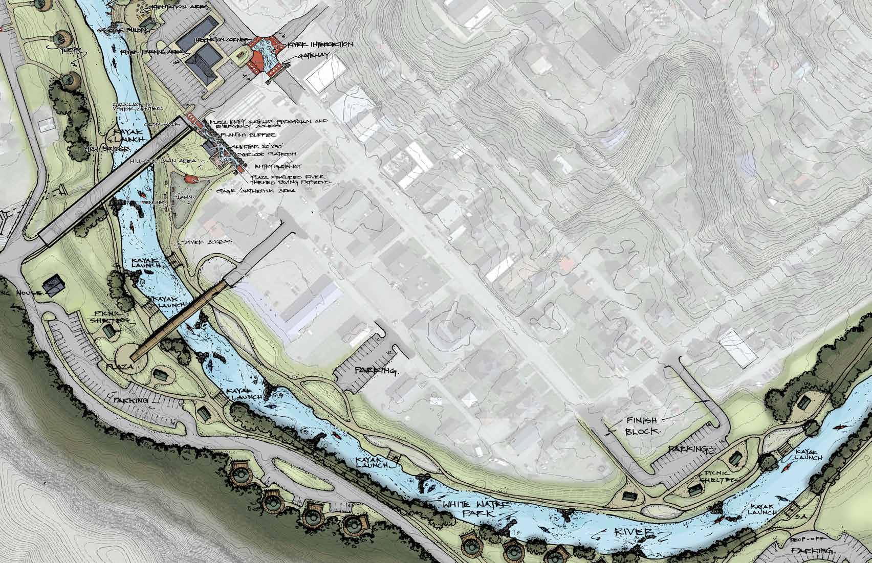
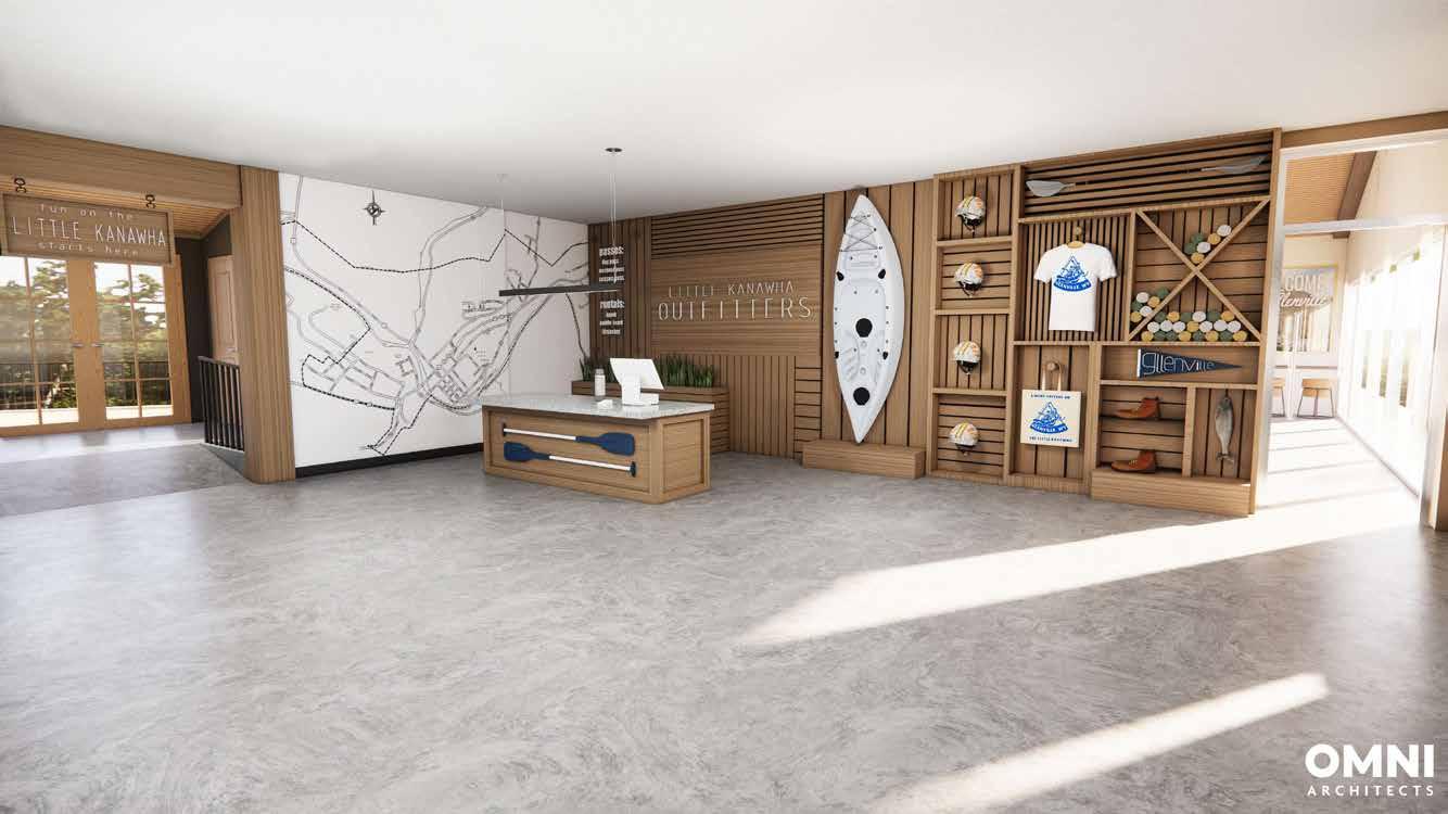
The downtown riverfront plan is the central focal point of the overall masterplan. Providing a mix of day-use and extended stay opportunities, the area is positioned to bring in additional tourism from the surrounding regions. At the heart of the plan is the white water kayaking park; providing the area with high energy, active recreational use of the river. Utilizing the white water classification system, Class 1-3 rapids are expected to be created, providing fun for a whole family. A generous amount of area is provided for passive recreational opportunities, including picnic shelters, open park areas, and a river trail. An overlook platform, seating area, and rentable pavilion adjacent to US 119 and Powell St. will provide great vantage points of the action happening on the river. An event lawn sits between the overlook and the river and provides a venue for small programming. A welcome center is positioned at the intersection of WV-5 and Walnut Street and features a viewing platform, restaurant, rentals, and town information. This will serve as a hub for residents and tourists visiting Glenville to learn about the many great amenities offered. The Masterplan includes:
Amenities:
• Existing building converted to a welcome center (multi-use, rentals, coffee shop, meeting space, Air B and B)
• Orientation area for kayak and canoe rentals with a new launch ramp
• Overlook platform
• 20’ x 30’ shelter
• Event lawn and stage
• Historic bridge conversion to pedestrian bridge with plaza
• 8 Picnic shelters
• 14 Rental yurts
• 7 Park model lodging units
• Ample day-use parking
• 10 Kayak launch/exit points
• Entry gateway at intersection with information signage
• Multi-purpose trails on both sides of river connecting to arbuckle and manley properties
• Safe pedestrian path along Walnut Street, connecting Gilmer High School and the WVU Medicine Waco Center to the downtown area, with stream restoration along Turkey Run


Example Yurt Example Park Model Unit


Manley Riverfront Campground Plan
Overview
The Manley Riverfront Campground Plan provides additional types of extended stay rental opportunities including rental cabins, yurts, and RV campgrounds. Large open park area are a great resource for passive recreation with adjacent trails for hiking/biking to different areas of the town and to Burnsville to the East. The pedestrian bridge provides access to the other side of the river connecting the trail system to the downtown area and to the Sue Morris Sports Complex. This will greatly impact the economic success of Glenville with the addition of the lodging and access to the sports complex as lodging in the region is very limited, and is needed for the extended success of Glenville and its amenities. The Masterplan includes:
Amenities:
• 17 Rental Cabins
• 115 RV Space Campground
• 3 Large Park Areas
• 6 Rental Yurts
• Welcome Center
• Pedestrian Bridge
• 10 Kayak Launch/Exit Points


River Activities for All-Ages
Open-Space Gathering Area
Rental Cabin
RV Campground


