Sydney Airport sees over 40 million passengers passing through each year.
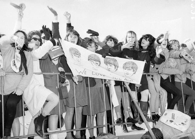
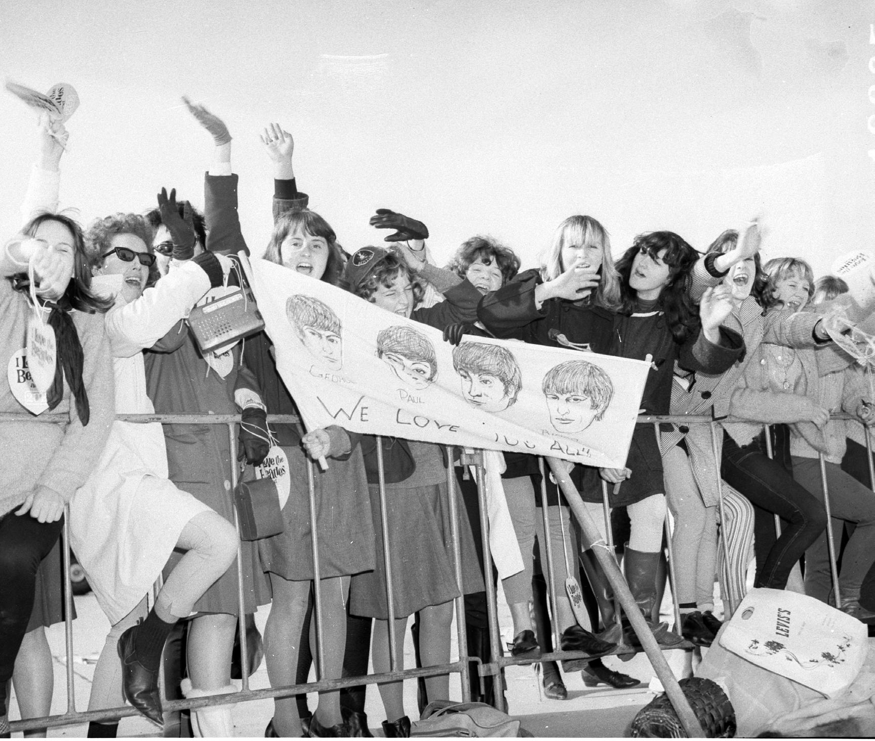
While many famous people have passed through over the years, in 1964 a group of extra special guests arrived, greeted by a crowd of screaming fans.
The world had been swept up in Beatlemania and Australia was no exception. The Beatles: John Lennon, Paul McCartney, George Harrison and stand in drummer Johnny Nichol arrived at Sydney Airport on June 11.
Despite heavy rain and cold conditions, hundreds of fans camped out overnight, prepared with blankets and vacuum flasks in hopes of catching a glimpse of the stars.
150 police were on hand to try and control the excited crowd of over 1,000 screaming fans.
Due to illness, drummer Ringo Starr had delayed his travels. Although he arrived a few days later, he was welcomed with the same enthusiasm as the rest of the band.
This was the Beatles first, and only tour of Australia, which spanned nearly three weeks.
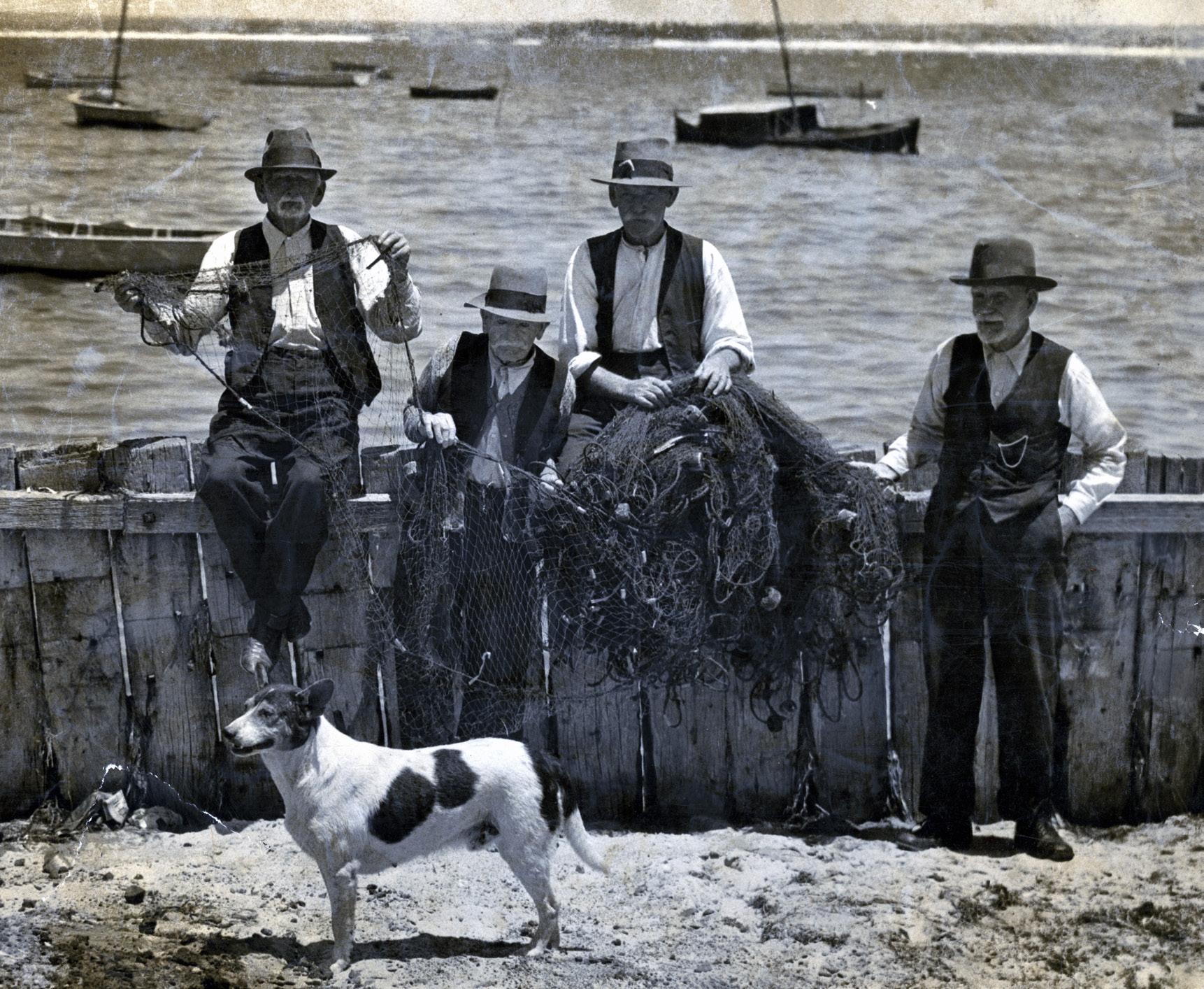
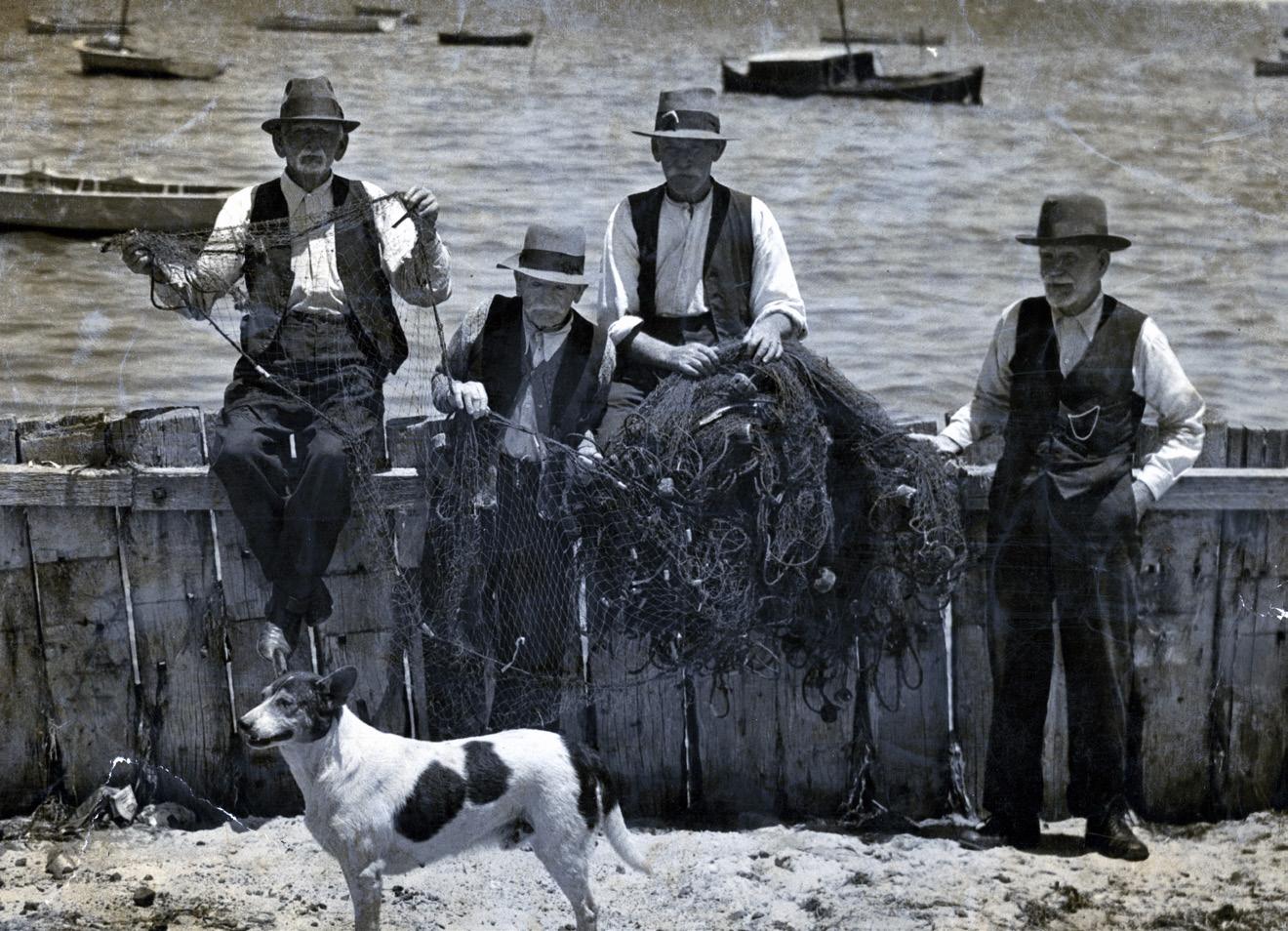
Fish were once plentiful off the shores of Botany Bay and fisherman built their huts nearby from about the 1830s.
The fishing town in Botany was known as the Village of Booralee, and was concentrated in Booralee Street, Bay Street and Luland street. The fishing town harboured a close-knit, lively community of fisherman and their families.
Catches were taken into Sydney in the early morning to supply the markets. The fishing industry thrived for well over 100 years, supplying Sydney with plentiful bounties of fish, prawns and oysters, with the last fisherman closing up shop around 1970.
By that time, the bay had undergone some dramatic changes including the development of Port Botany, Sydney Airport and Foreshore Road. These changes meant the fishing town was cut off from the water with the streets no longer having direct access to the bay. The few remaining weatherboard cottages that still stand are the last remaining fragments of the fishing village.

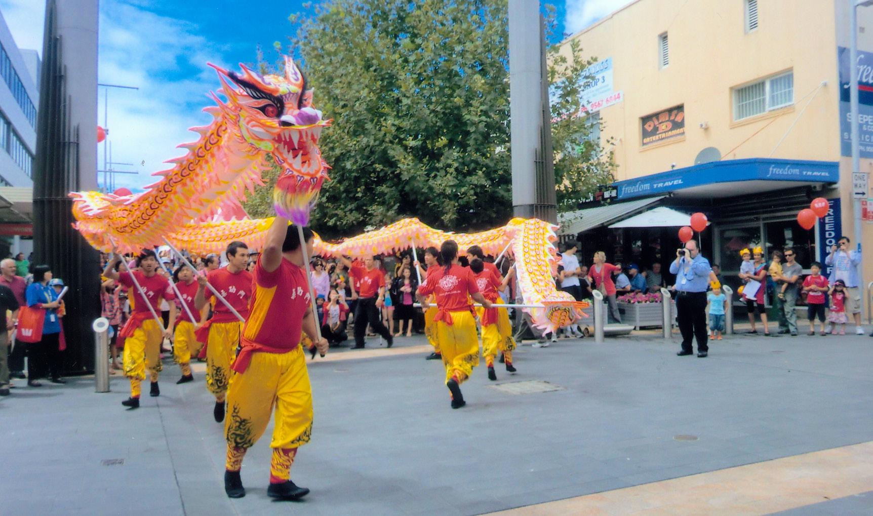
Almost half of our residents were born overseas and 53% of people speak a language other than English at home.
Celebrations are held throughout the year for dates of note and festivities for numerous cultures. Bayside Council is committed to fostering an inclusive and equitable community that takes pride in its multicultural diversity. Our diversity fosters a vibrant tapestry of cultures, perspectives, and experiences.
Our strong ties include the Chinese and Greek communities, along with many others, with a multicultural community built through the years. We enjoy an assortment of festivals like the Greek Festival held February to March, and events for cultural days like Lunar New Year, Ramadan, Easter, and Harmony Day.

Have you ever tried corned beef and celery loaf?
Or how about salad squares made of jelly?
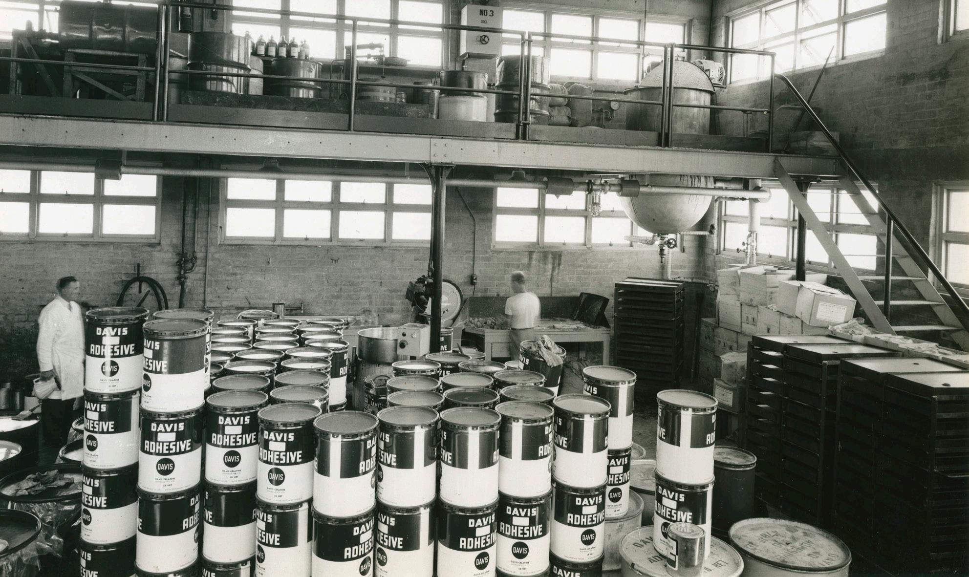
Australia once relied heavily on overseas gelatine supplies, but wartime isolation necessitated the development of a domestic gelatine industry.
In 1917, George F. Davis purchased 20 acres of land surrounded by sand dunes on Spring Street, Botany. This site was strategically chosen for its proximity to other industries, whose by-products were essential for gelatine production. The company produced both edible gelatine and various types of glue.
With a vision of having Davis Gelatine products in every household, cookbooks with recipes based on the exact strength of Davis Gelatine products were released, with warnings that satisfactory results couldn’t be relied upon if other gelatines were used. It wasn’t long before ‘Dainty Dishes’ became a household name.
Despite its success, Davis Gelatine closed its Botany factory in 1990 and eventually relocated to Queensland.
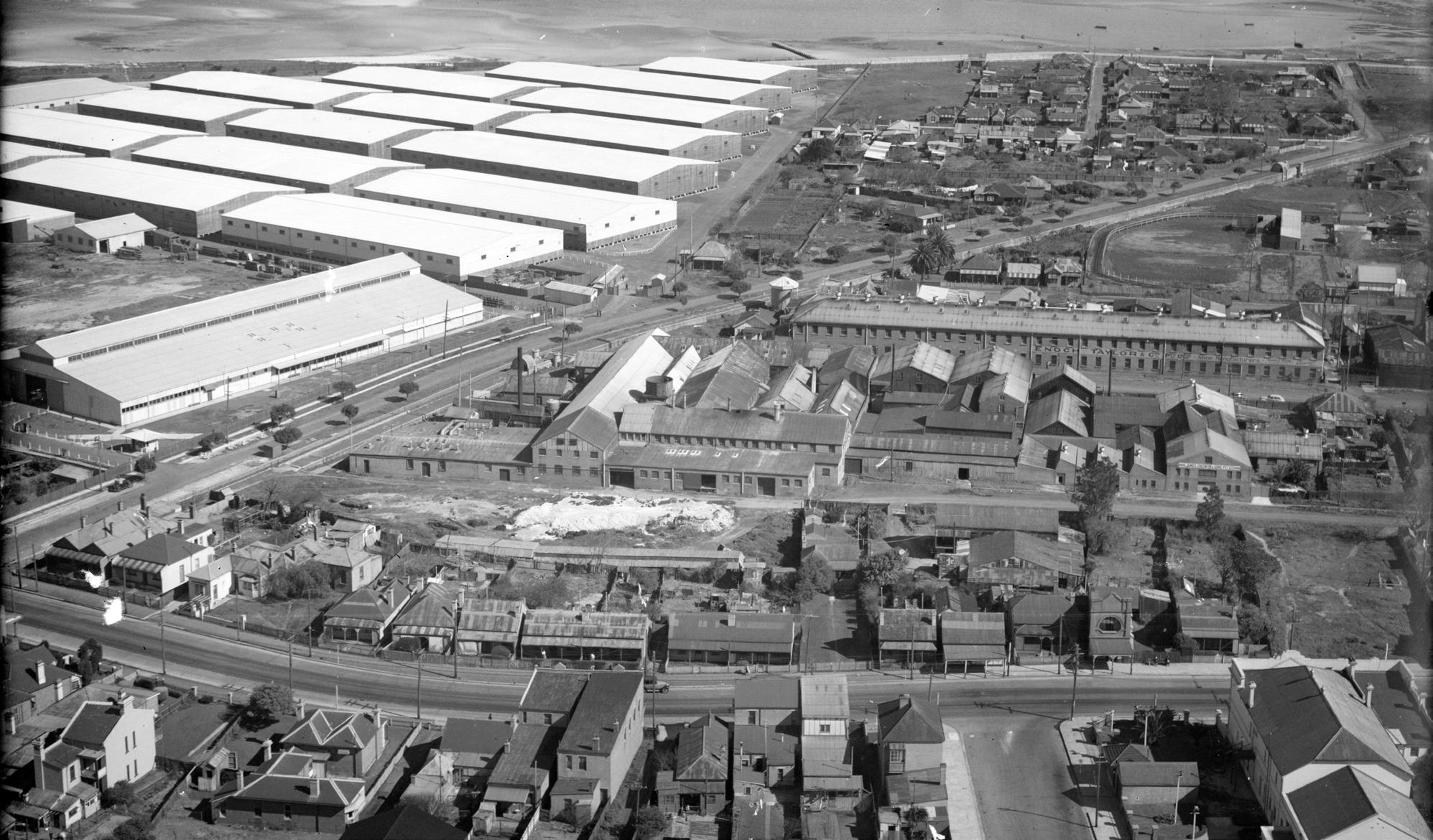
Enoch Taylor & Co was founded by Enoch Taylor in Melbourne in 1851 as a footwear business that imported shoes and boots from overseas.
The company eventually expanded throughout Australia and overseas.
In 1892, they acquired a factory at Underwood Avenue, Botany, for boot and shoe manufacturing, initially employing about 90 workers. Over the years, various additions and improvements were made to the site, and by the late 1930s, the company employed over 350 people. The firm was well known in the industry for producing highly skilled apprentices.
Enoch Taylor & Co. produced all classes of footwear and even had a separate on-site factory for making lasts and wood heels. They outfitted a trailer with displays of their latest samples, taking it to country towns where clients could then inspect their range.
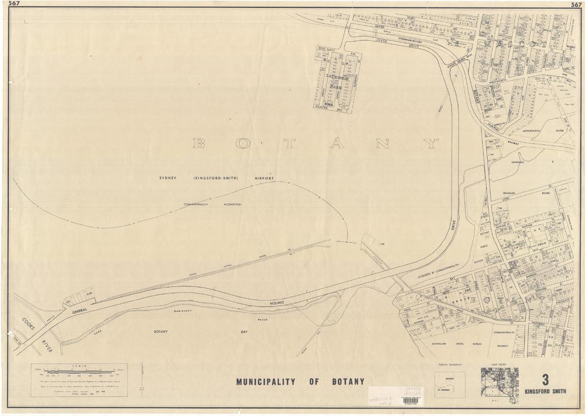
It was once a small, vibrant suburb located at the mouth of the Cooks River, but over time it was subsumed to make way for the expansion of Sydney Airport. It was a small but active community, centred around only a few streets.
Lauriston Park Estate was surveyed, and its lots were first advertised for sale in 1902. Progress at nearby Mascot Aerodrome moved quickly from a private airspace in 1919, to the government purchasing 161 acres of grassy and swampy paddocks close to Lauriston Park in 1921. With increasing air traffic by the end of the 1920s, it was decided the site needed to be expanded to meet air traffic demands.
The first gravel runway was laid in 1933 and in 1936 the aerodrome was given status as an international airport and officially renamed the Sydney (Kingsford Smith) Airport.
From there, the airport continued to expand, and it was upgraded several times. As the airport was expanded, the people of Lauriston Park slowly lost more and more of their land.
In 1981 the government obtained the roads of Lauriston Park, meaning residents needed to acquire a license that authorised them to use the roads to their house. Despite the increasing difficulties of living in Lauriston Park, some residents remained as long as possible. When the last resident succumbed to the acquisition in December 1990, the suburb disappeared completely.


There were previously a number of market gardens throughout the Bayside area, which supplied fresh produce to Sydney.
Market gardening in the region thrived from the late 19th to mid-20th century, largely due to the efforts of European and Chinese immigrants. They supplied fresh vegetables and herbs to markets in the city, travelling in horse drawn carts or by foot. Their expertise in irrigation and crop rotation contributed to sustainable farming practices.
However, urban expansion, rising land values, and shifts in economic priorities led to the decline of small-scale market gardens. By the late 20th century, many had disappeared, replaced by housing and infrastructure.
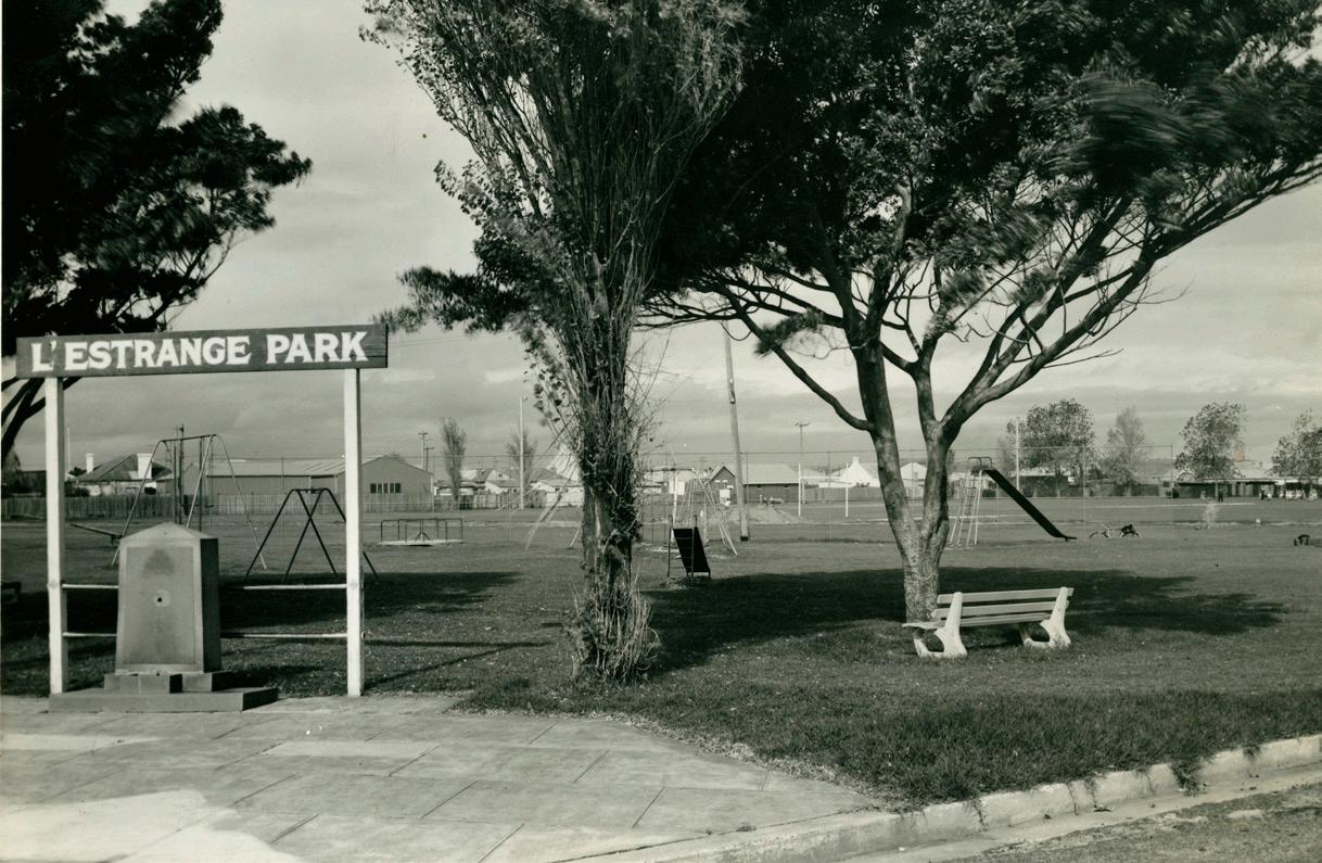
The land on which L’Estrange Park is situated was once occupied by Chinese market gardeners. The land was purchased by Council in 1927 for £4,000.
Council levelled, filled and fenced the land and built dressing rooms for sports. The park was officially opened in 1931 with a gala day and large procession through the streets that attracted over 5,000 people. The park is named after Alderman M. J. L’Estrange who served Council from 1914-1934 and was Mayor between 1926 and 1929.
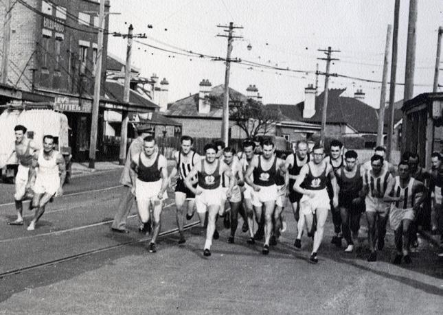
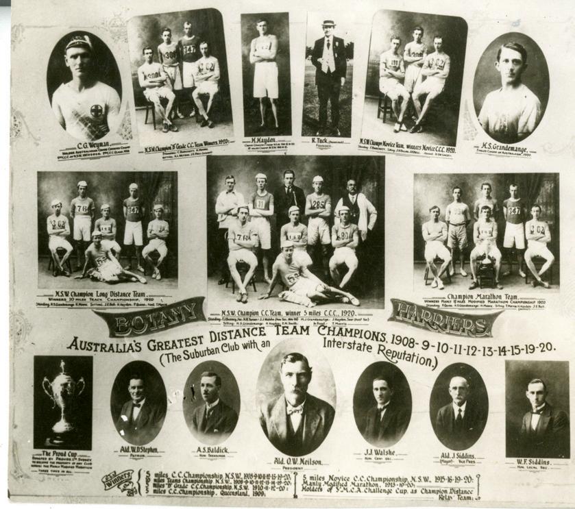
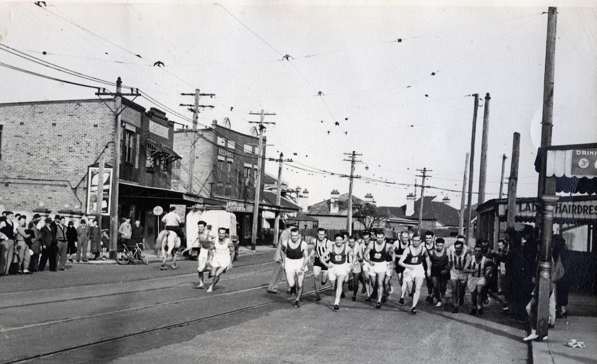
Founded in 1907, the Botany Harriers achieved remarkable success, winning an impressive 11 NSW State Team Championships between 1908 and 1924. As the club proudly stated, they were a “suburban club with an interstate reputation.”
Several of its members went on to represent Australia at the Olympics. One of the most renowned was Jimmy Carlton, the ‘schoolboy wonder,’ who competed in the 1928 Amsterdam Olympic Games. Although he seemed certain to be pre-selected for the 1932 Los Angeles Games, he made the controversial decision to pursue training for the priesthood instead.
A lasting legacy of the Botany Harriers is the Hensley Athletic Field, named after former president Chic Hensley. The club first proposed the idea in the 1960s and collaborated with Council to create what, at the time, was considered a state-of-the-art athletic track.
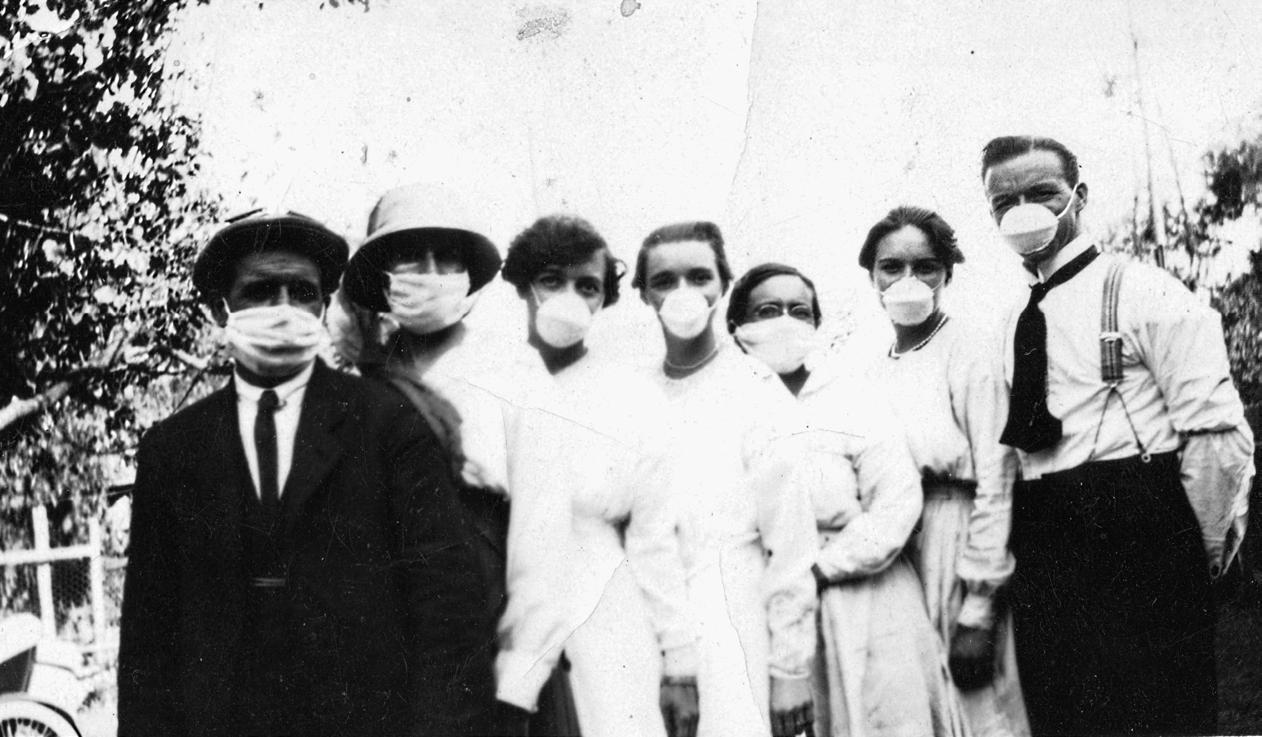
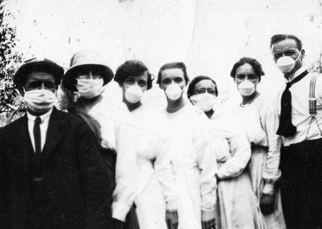
The Influenza pandemic also known as the Spanish Flu or Pneumonic Influenza, of 1918 –1919 was a series of deadly outbreaks of the flu that resulted in the deaths of up to 50 million people worldwide.
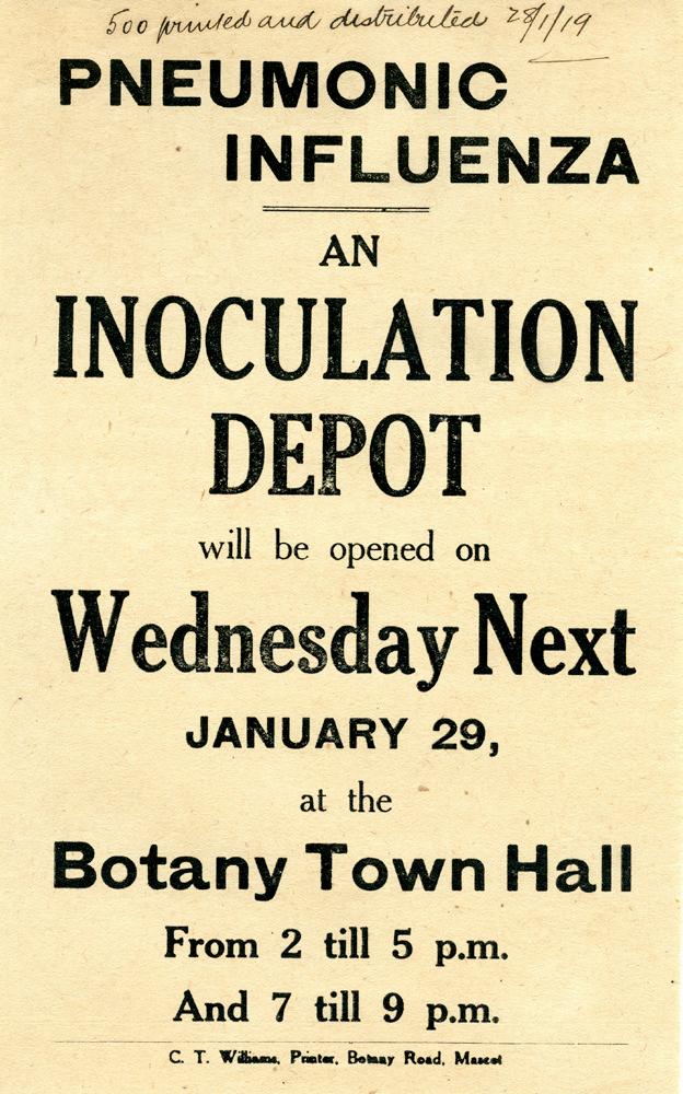
The virus spread quickly around the world as soldiers were returning home at the end of the war. Australia’s remoteness and the rapid implementation of maritime quarantine measures helped to delay the arrival, but cases inevitably started to appear across Australia. By the end of January 1919, tight restrictions had been introduced into NSW. Theatres, picture shows, churches, racecourses and schools were closed, public meetings were prohibited and from early February masks were mandatory in public places.
Handwritten lists show that on their first day of operations on 29 January 1919, 592 people were inoculated at Botany Town Hall. An inoculation clinic was also opened at Mascot Town Hall and Rockdale on this day.
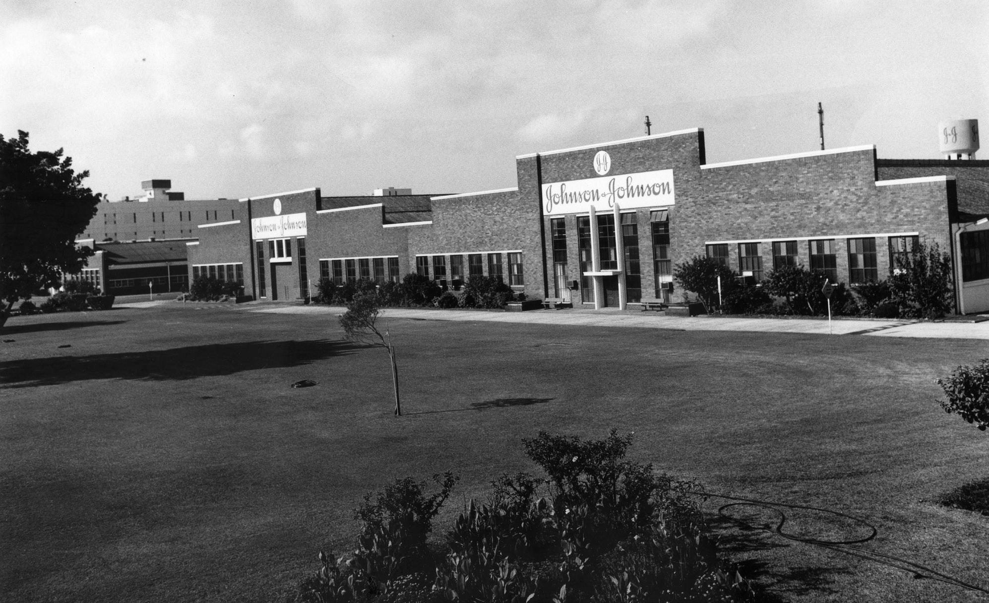
Between 1936 and 2000 the factory on Stephen Road produced a multitude of products ranging from cotton wool and toothbrushes to its iconic baby powder.
One of its more intriguing products was surgical catgut, a type of thread once used for sutures. Today sutures are made from synthetic material. In the 1950s J & J produced theirs using sheep intestines.
The factory thrived for many decades. Slowly, however, globalisation and rationalisation began to reduce the number of products made here. For example, in 1985 J & J decided to move all its Band Aid production to Japan.
When the company closed its Botany plant in 2000, many employees were sad to leave but acknowledged the factory’s closure as a ‘sign of the times’.
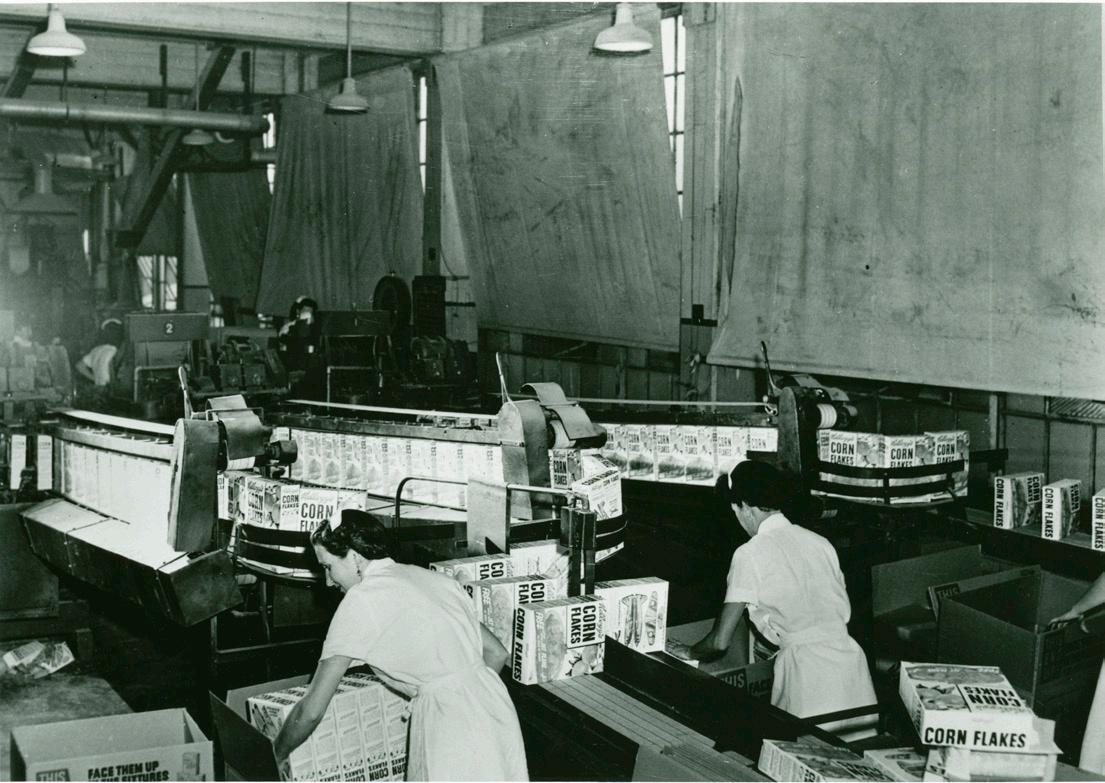
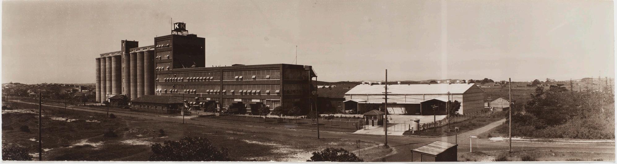
Did you know that Corn Flakes celebrated 100 years of manufacturing in Australia in 2024?
The Kellogg brothers revolutionised breakfast when they created Corn Flakes. Corn Flakes first arrived in Australia in 1924 when a specialist was sent to set up a space in a rented premise in nearby Chippendale. Due to the overwhelming success of the breakfast cereal, four acres were secured on Stephen Road, Botany, and a permanent plant was opened in 1928.
Since then, the plant has been the manufacturer of a number of products such as Nutri-grain, which was created uniquely for the Australian market and still to this day is only sold here and in New Zealand.
The plant has undergone a number of updates over the years to keep up with demand and advancing manufacturing technology but still stands in the same location today.
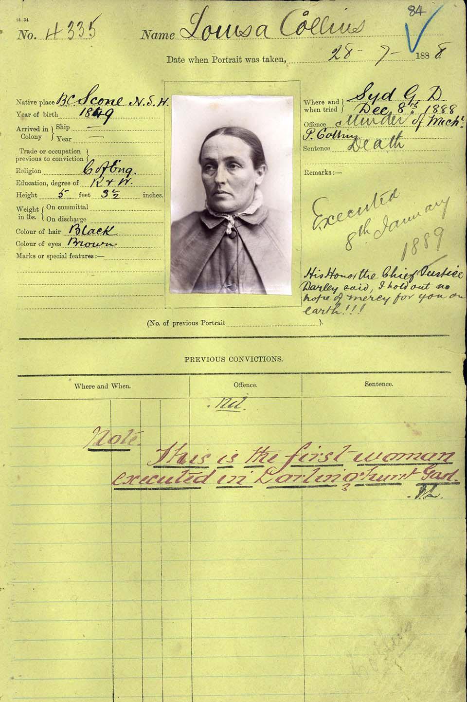
Did you know that the last woman hanged in NSW was a local?
Louisa Collins, a housewife and mother, was accused of fatally poisoning her two husbands with arsenic in the late 1880s. Her scandalous story, sensationalised by the press as the ‘Botany Bay Murderess,’ and the ‘Borgia of Botany’, captivated New South Wales.
Originally from the Upper Hunter Valley, Louisa married Charles Andrews as a teenager and moved to Frog’s Hollow, a now lost residential area in modern day Banksmeadow. After Charles’s sudden death in 1887, she quickly married her younger lodger, Michael Collins, which raised suspicions. When Michael also died suddenly in 1888, authorities were alerted.
Despite three juries failing to convict her, a fourth jury found her guilty, and she was hanged at Darlinghurst Gaol on 8 January 1889, becoming the last woman executed in NSW. In recent times, many have questioned the case, examining if she was unfairly convicted or if she was truly Australia’s first serial murderess.
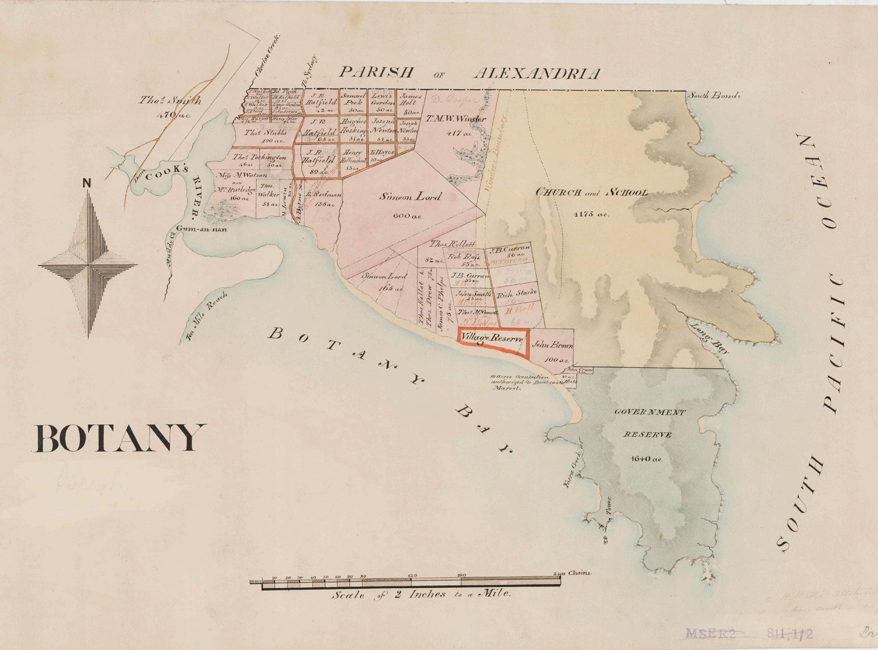
Mahroot,also known as ‘Boatswain’ Maroot,was born in the 1790s.
His father was leader of the Gameygal/Kameygal clan, who occupied the north side of Kamay (Botany Bay).
Having learned some English in Sydney, he worked as a seaman and was one of the first Indigenous men from the Sydney area to work on colonial sealing and whaling ships. In 1832 he was granted 10 acres of land on Botany Bay, by Governor Richard Bourke, where he built five slab huts and leased them out.
In 1845, he claimed to be the last remaining male of the Botany Bay tribe, which had once numbered 400 people.
Mahroot spent his last years working as a boatman and hunting and fishing guide for patrons of the Sir Joseph Banks Hotel. He lived in a bark hut on the grounds of the hotel, where he died in the 1850s.
In 2014 the Botany Historical Trust recommended the naming of a new street in Botany in honour of Mahroot; the name was adopted and officially gazetted in 2016.
In the mid-1800s, Victorian enthusiasm for flowers and plants was widespread and in Sydney the nursery and seed trade developed rapidly.
Many nurseries in greater Sydney developed their stock on site at the urban edges of the city. The Bayside and St George region had numerous large- and small-scale nurseries. Swamps were converted to gardens and low-lying lands became prominent nurseries.
Searl & Sons was started in Parramatta in 1849 by Frederick and Luisa Searl. In 1887 their sons John and Frederick bought land at Banksmeadow which became part of the Botany nursery. The nursery was 17 acres and grew flowers, shrubs, trees, ferns and palms. It was synonymous with the nursery and floral trade during 19th Century Sydney. In the decade after 1904 the company was one of the largest in Australia, with nurseries and specialised sites spread over Sydney and into the Southern Highlands.
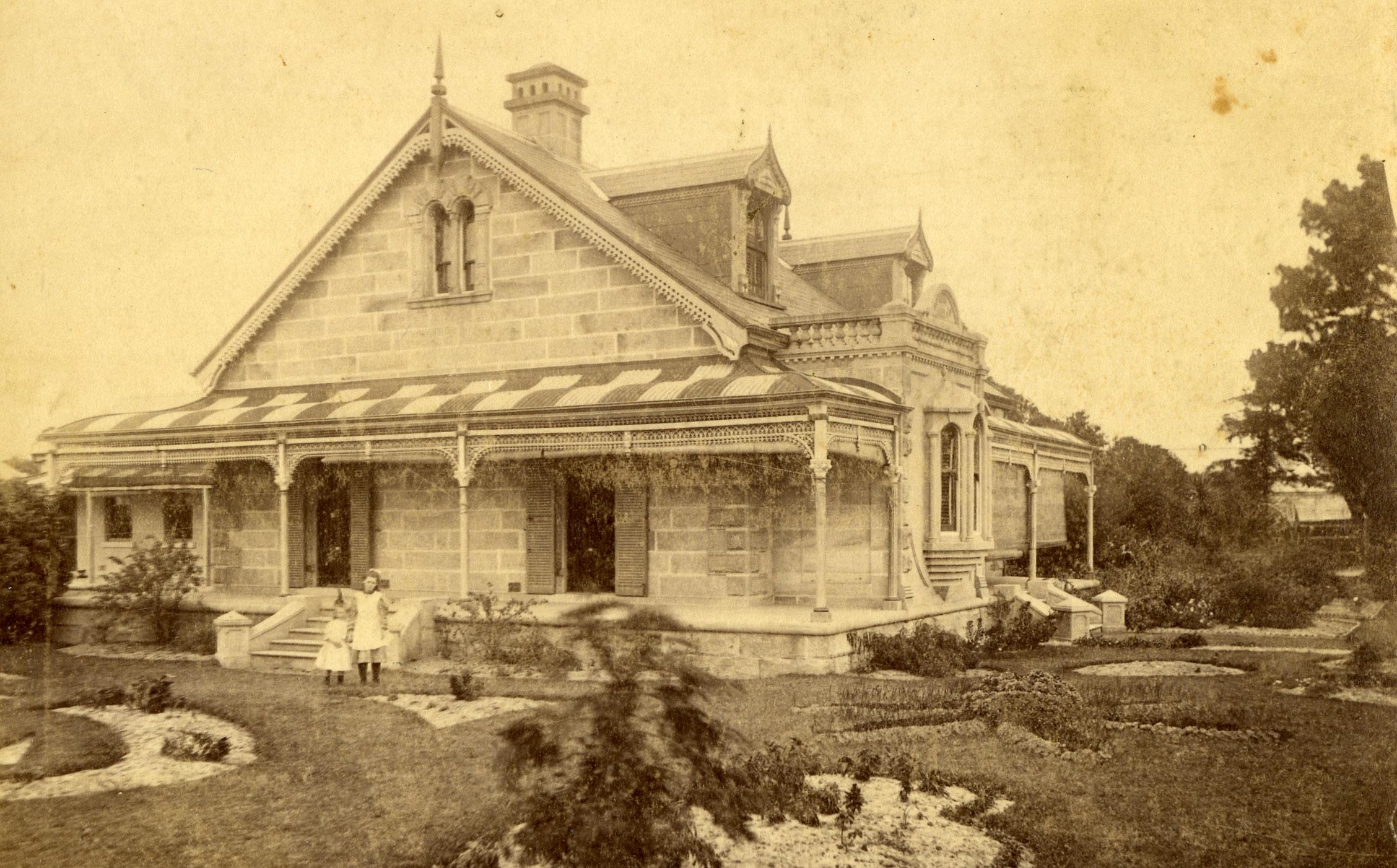
Rosevale Nursery, Rockdale, was heralded as one of the most successful nurseries in southeastern Sydney during the 19th century. It was established by John Illife (c.1840-1910) who also cultivated a 12-ha plantation nursery in Bexley to accompany the Rosevale Nursery.
At the centre of the Rockdale nursery stood Illife’s family home, Rosevale Villa, built in 1873. It was located on Rocky Point Road (now Princes Highway), Rockdale, between Bestic and Bryant streets. Rosevale Nursery was devoted to growing and supplying exotic and ornamental plants to colonies across Australia. In the 1880s it was compared with the Jardins de Ville in Paris, growing more than 500 varieties of roses, 30 000 fruit trees and thousands of camellia specimens, with a dozen plant houses and a hot house for tropical plants.
In the 1890s Illife & Co’s Nursery became Milner and Smith and then Milner & Co.
The Olympic torch relay begins in Olympia, Greece, and then travels through various cities to highlight the unique characteristics of each region and promote a message of friendship.
The journey culminates in the lighting of the Olympic cauldron, symbolising the official commencement of the Olympic Games.
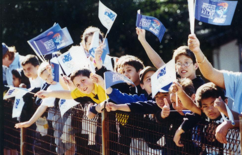
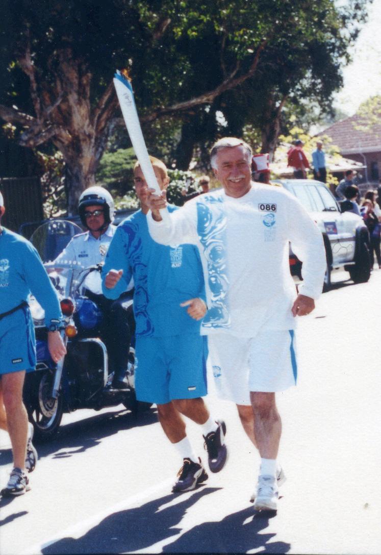
In the lead up to the Sydney 2000 Olympics, the flame travelled across Australia for 100 days, passing through over 1,000 suburbs and towns, being carried by over 11,000 torchbearers.
On 12 September 2000, the torch made its way through a number of Sydney suburbs including Bexley and Bardwell Park.
On Thursday 14 September 2000, an estimated 10,000 people crammed along Botany Road, Page Street and Wentworth Avenue to cheer on the torch bearers and escort the runner as the torch went through Mascot, Eastlakes and Botany.
Amongst the honoured torch bearers was Ron Crawford, esteemed former president of the Botany Harriers Club, and Olympic race walk competitor.
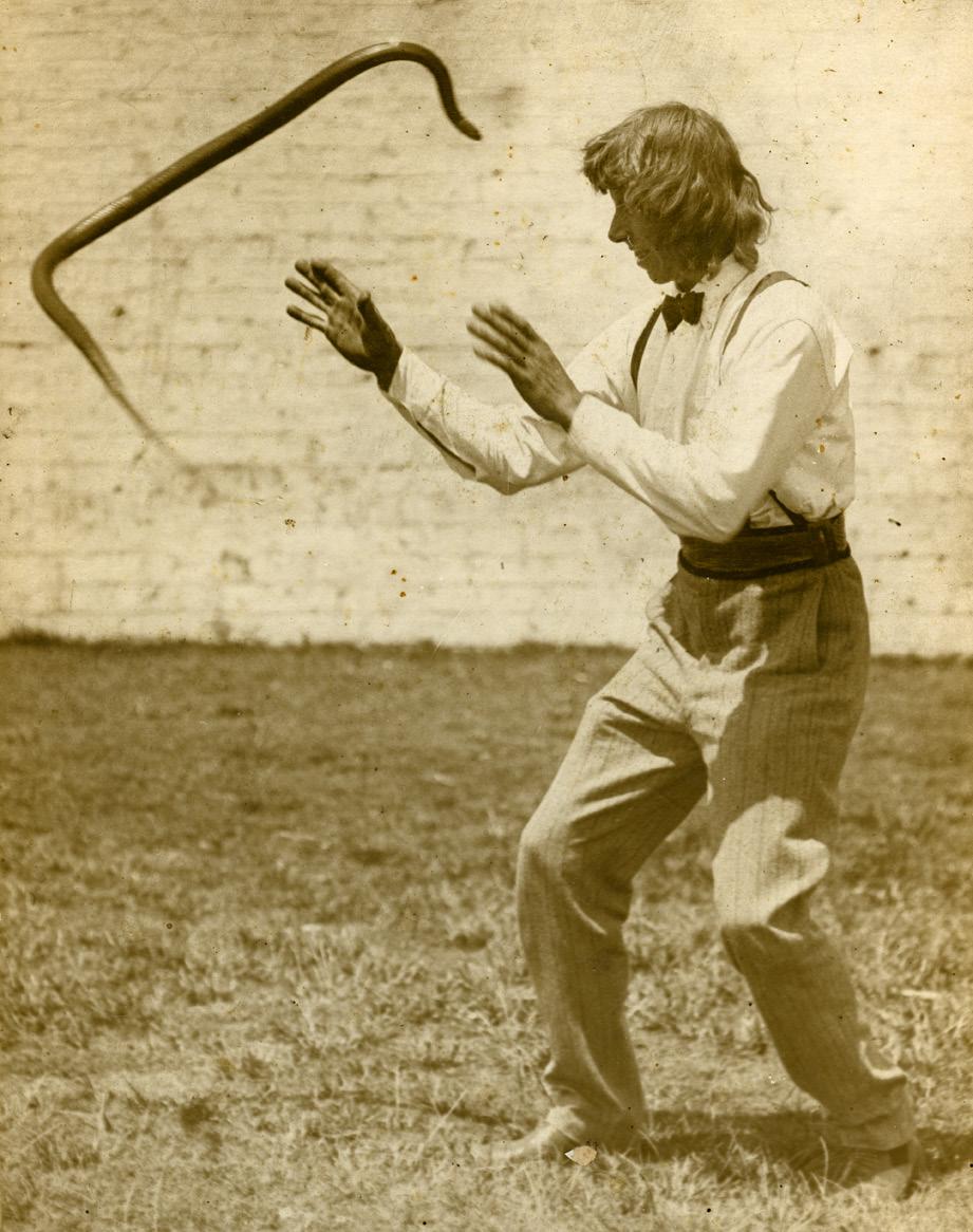
How would you like to live next door to Snakedomia?
That was the name of a local Mascot house where “Professor” Frederick Fox, a widely known snake charmer, and his family resided.
The house may have looked ordinary, but inside lay hundreds of snakes. Brown, black, tiger, carpet, diamond and death adders filled the house. To keep up with the demand of feeding his snakes up to 20 dozen frogs a day, Fox turned to breeding frogs in his backyard.
Professor Fox was one of the many who tried to peddle snake bite antidotes, and in February 1914 he travelled to Calcutta to demonstrate his potion to the Indian Government, with backing from a Sydney businessman.
On 28 February he had held several successful demonstrations including treating a goat that had been bitten, at the Zoological Gardens, Calcutta. When Fox was accidently bitten by an Indian krait, he applied antidote to the four bites he saw and went on with his work. Unfortunately, he did not see the snake’s fifth bite and died later that evening.
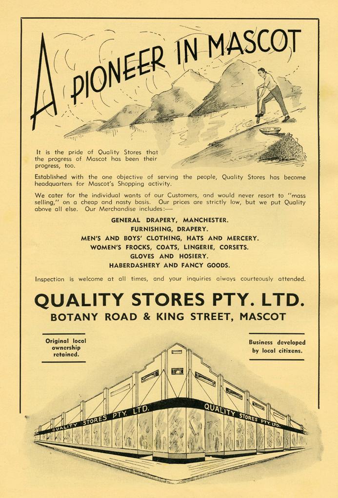
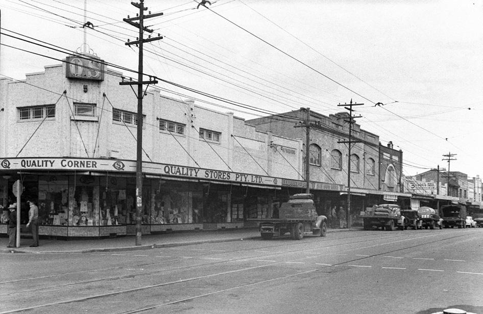
In 1933 the local shopping scene dramatically improved when department store “Quality Stores” opened its doors in Mascot.
Prior to the opening of the department store, Mascot residents would catch the tram into the city to purchase clothes and many household items. Mr A. H. Thorsby, a resident of Mascot, saw the need for the area to have a properly equipped department store to service the local residents.
It was a place where residents could have the convenience of shopping locally for their clothing and other household items such as manchester, home furnishings and perfumes. Its early ads urged residents to shop locally and ‘save tram fares’. It also suggested that ‘by shopping locally you will improve your town and property as well’.
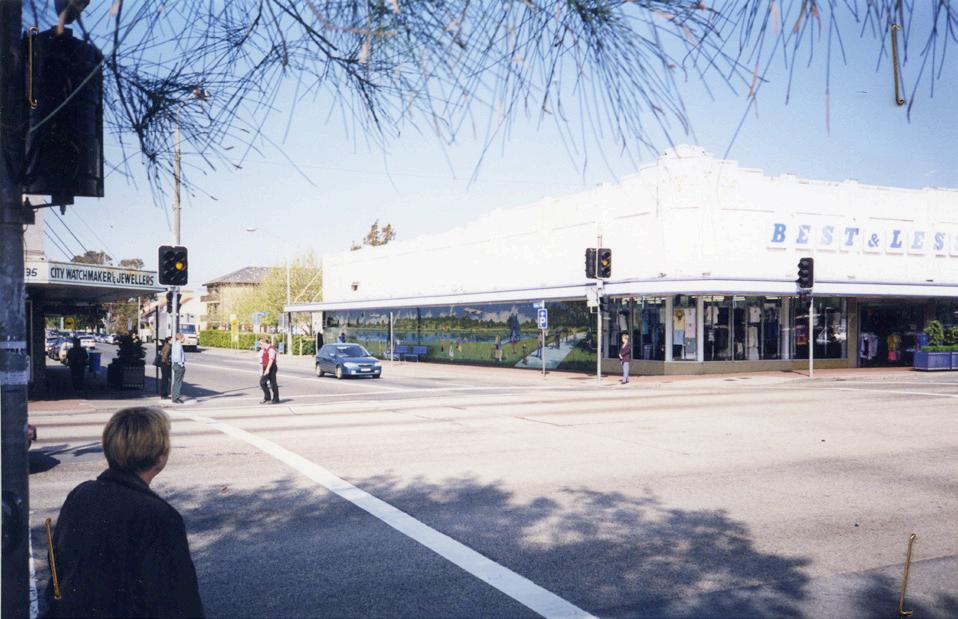
The store was located at the corner of Botany Road and King Street, a spot locals might remember as the former site of Best & Less for many years, before it was replaced by Auto One.
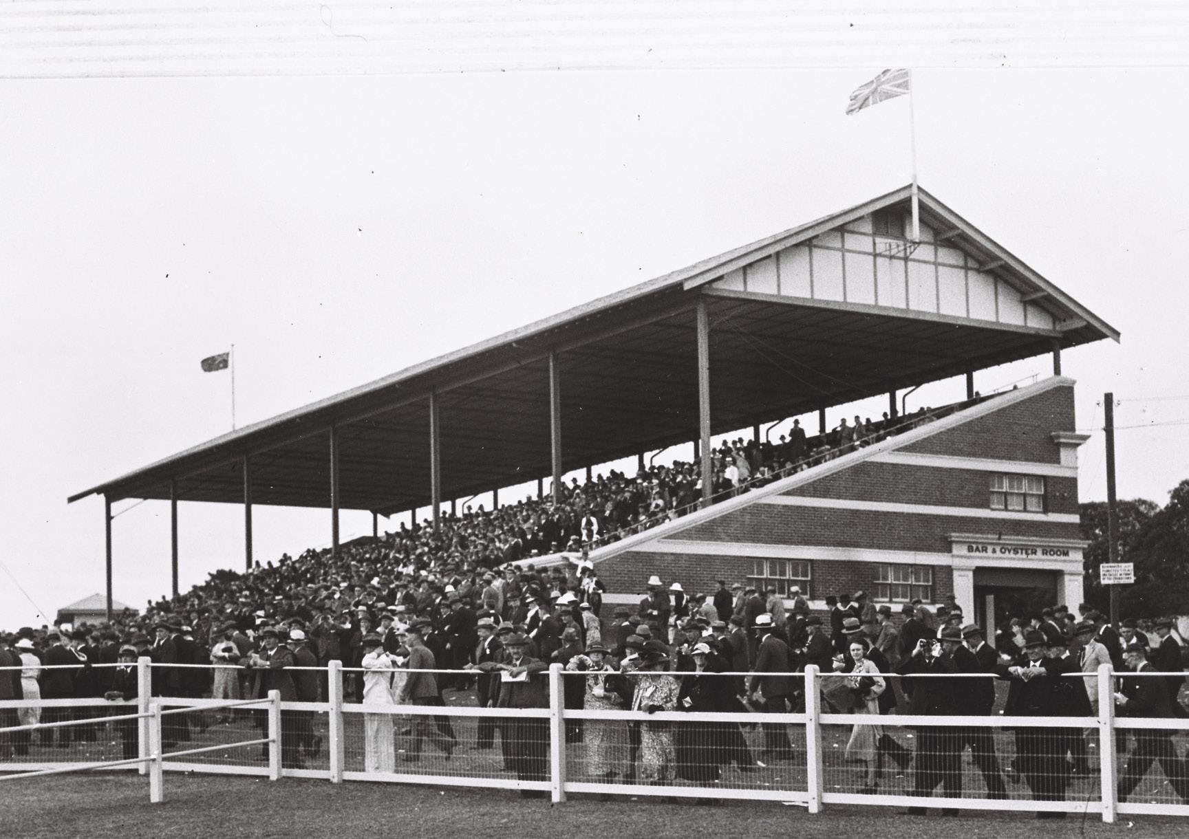
Horse and pony racing and events were among the earliest sports in Bayside, thriving due to open grounds and proximity to the city.
Wagering played a crucial role in its development, providing financial incentives for owners and spectators, making races more exciting and drawing large crowds.
Brighton racecourse opened in 1895, not far from Lady Robinsons Beach. The track held pony races and trotting events until it closed in 1911.
The first meeting at Moorefield racecourse, Kogarah, was held in October 1888. The last race was on July 14, 1951. It closed mid-1955 to be used for educational institutions, including St George TAFE, and as a residential area.
Rosebery had two racecourses: the first opened near the corner of Botany and Gardeners Road in 1895 and later became a greyhound track.
The second opened in 1906, further down Gardeners Road, and was a major attraction.
In 1924, a pony meeting at Rosebery attracted 15,000 spectators with 170 bookmakers in the leger and 114 in the paddock. In both world wars, Rosebery Park Racecourse served as a parade and military training ground. The land was eventually sold in 1961 for development.
Ascot Racecourse, which opened in 1906, drew 2,300 racegoers at its first meeting. It closed in 1941 and was later demolished for Sydney Airport expansion.
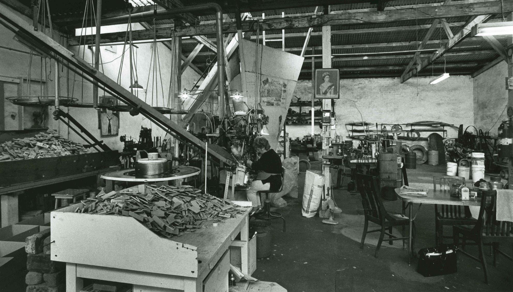
Arnold Wes Standfield began making mouse traps in the garage of his Mascot home.
His business eventually outgrew his space, and a factory was established in Baxter Street. Standfield used scrap metals and parts to build the first mouse trap machine, which was able to mass produce traps by machine in 1944. The machine was able to make 1,000 traps an hour, taking just 1.5 seconds to make each one.
The first traps were made to be reusable, made entirely out of metal. This model was eventually replaced by a wooden base that customers could dispose of after use. The company also produced a larger trap, called the choker or the family finisher as it could trap and kill four mice at once.
Besides their famous traps, the company also churned out a series of side lines such as clothes pegs and pot stands. These goods kept the factory going when demand for traps was low. The factory remained in operation until 2000.
Standfield Park, located in Church Avenue, Mascot, was named in 2016 in honour of Arnold Wes Standfield.
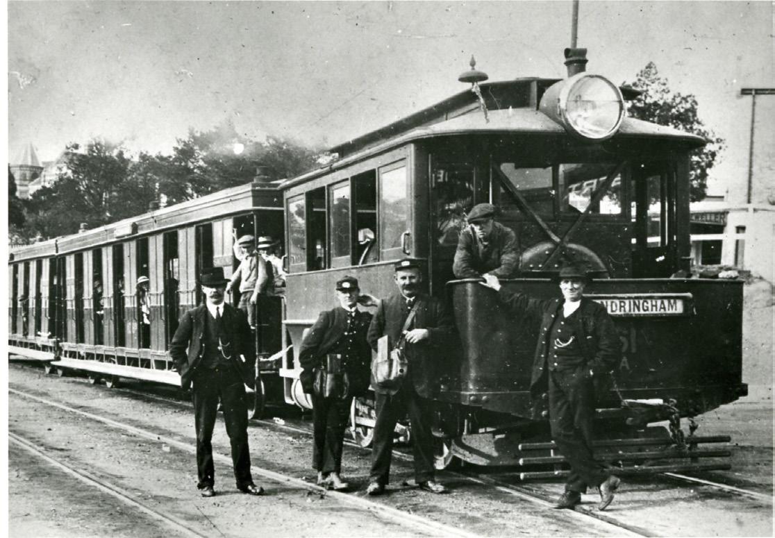
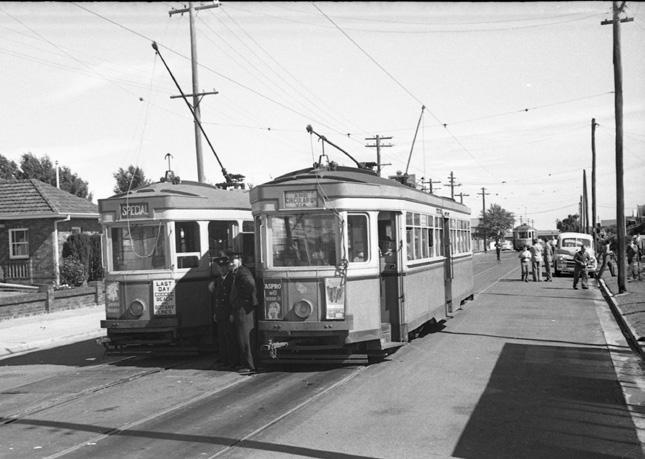
Sydney once boasted one of the world’s most extensive tram networks, operating from 1879 to 1961 and becoming the largest in the southern hemisphere.
A direct line known as the Botany via Railway Square Line, used Botany Road to run services between Botany and Circular Quay. Three isolated tram lines connected Arncliffe to Bexley, Rockdale to Lady Robinsons Beach in Brighton-Le-Sands, and Kogarah to Sans Souci. All but the Arncliffe to Bexley line operated for fifty or more years, reflecting the popularity of the lines.
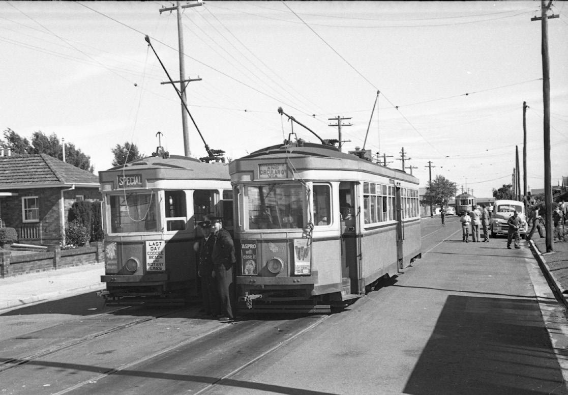
However, the rise of private car ownership led to increased road congestion and accidents. These issues may have been resolved but unfortunately, the NSW Government decided it could no longer maintain the network with the financial strain of WWII and the growing number of private vehicles, ultimately making the much-loved service unsustainable.
The network was gradually reduced, with the last Botany service on October 22, 1960, and the final tram journey from La Perouse to Randwick Workshops four months later.
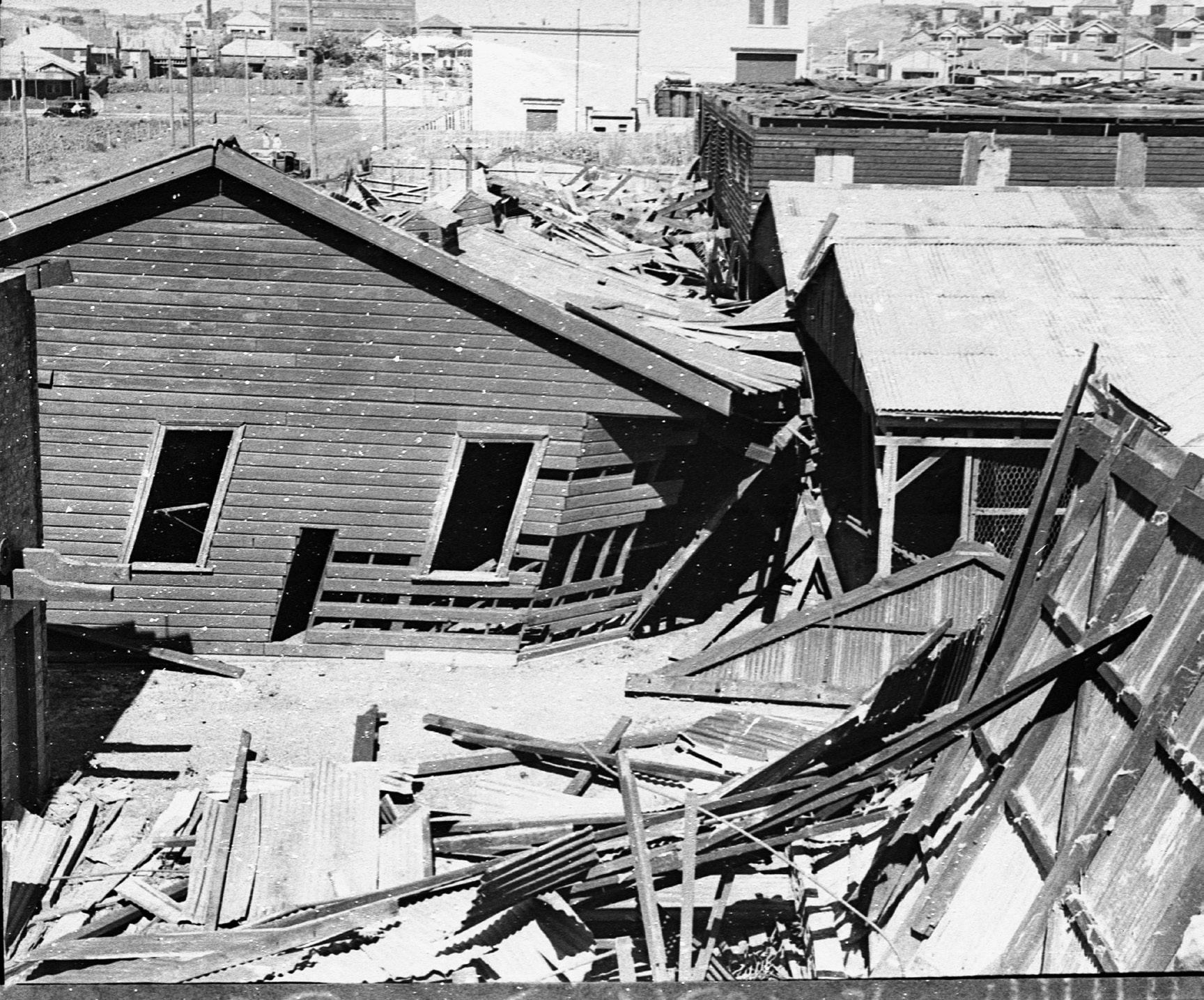
Would you believe a powerful cyclone once swept through the area, leaving behind a trail of destruction?
On 25 January 1937, at approximately 3.55pm, a cyclone swept through Sydney, causing extensive damage to residential and commercial buildings.
A large section of roof was blown off Banksmeadow Public School and the old grandstand and pavilion in Booralee Park collapsed, sadly killing 11-year-old, Arthur Green and injuring several others. Roofs from nearby properties were blown across the tram tracks and electric wires came down, causing hours of delays for trams and road traffic.
Several other local homes and businesses were damaged in the storm, with an estimated £100,000 of damage caused Sydney wide.
One of the storm’s more unusual stories was the death of almost 100 cows at a local dairy in Matraville. They were electrocuted after a damaged overhead electrical cable came in contact with their paddock’s fence.
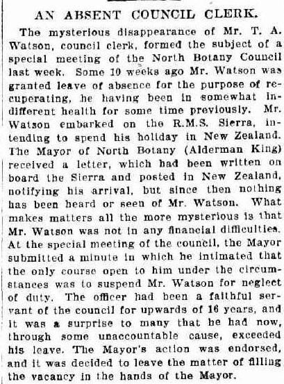
One of the most intriguing mysteries in North Botany (later renamed Mascot) around 1906 was the disappearance of the town clerk, Mr. Thomas Alexander Watson.
Mr. Watson, who had diligently served as town clerk for the Municipality of North Botany for more than 16 years, was granted a leave of absence in 1905 to recuperate from poor health. He boarded a ship bound for New Zealand and wrote to the Mayor, Alderman King, upon his arrival. However, after that initial letter, Mr. Watson vanished without a trace.
Ten weeks later, the Mayor convened a special council meeting to address the unsettling situation. He stated that the only course of action was to suspend Mr. Watson for neglect of duties.
Alderman King expressed his surprise, noting that Mr. Watson had been a ‘faithful servant of the council for more than 16 years and it was a surprise to many that he had now, through some unaccountable cause, ensconced his leave’.
The Council endorsed the Mayor’s motion and began the search for a replacement, leaving the mystery of Mr. Watson’s disappearance unsolved.
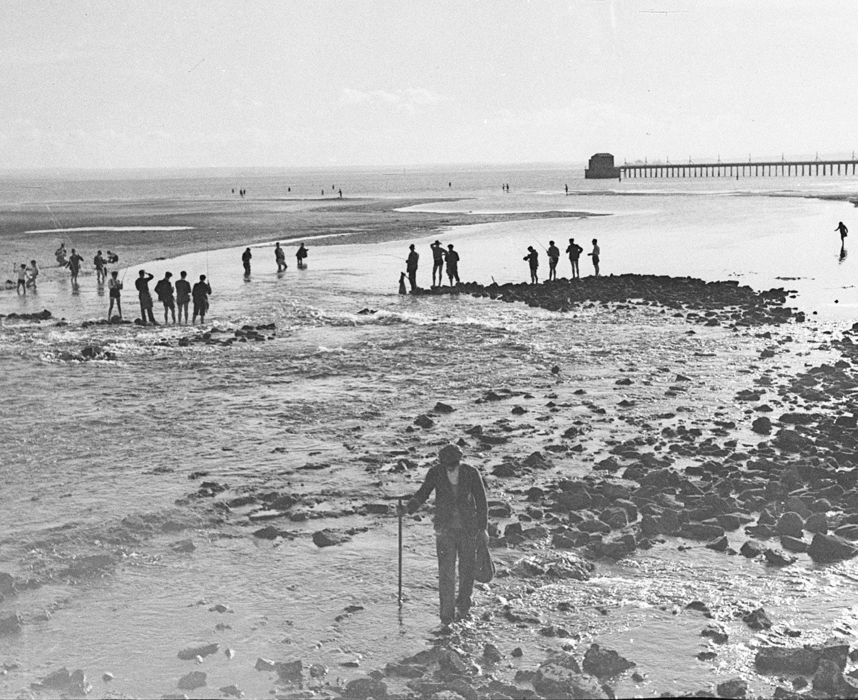
Can you imagine swimming next to a power station?
How about fishing there? Some locals might remember the hot baths that once stood near the former site of Bunnerong Power Station on Botany Bay’s shores.
To cool the condensers used at the nearby Australian Paper Mills, sea water was pumped in, circulated and then discharged back into the bay, in large troughs which had been built to prevent erosion of the sand from the discharge. These troughs, which were freely accessible and perfectly heated to 38°C attracted large crowds of people. On warm summer nights, nearly 300 people gathered to enjoy the water and to take advantage of the increased fishing opportunities that the warm water provided.
These sea baths were believed to have healing properties, and claims of remarkable cures were made by those who frequently visited them. In a 1931 newspaper article, a visitor from Pymble, recovering from a car accident, stayed for three weeks to heal his legs, and Botany resident Mrs. Fuller praised the baths for relieving her rheumatism and nerves after just four visits.
Now it’s your turn to map out the next chapter of our story
In the English language, words beginning with the letter X are rare, making it a unique and elusive letter in the alphabet. But in the world of exploration, discovery, and treasure hunting, X plays a significant role.
Think of X as the mark of a hidden treasure, the point on a map where something precious, significant, or mysterious is located.
Here, X represents more than just a letter — it invites you to reflect on the vast history we share and calls for you to fill in the blank.
What would your A-Zs stand for? A forgotten discovery, a pivotal moment, a person, or a place that shaped our past. The possibilities are endless. Share yours here.
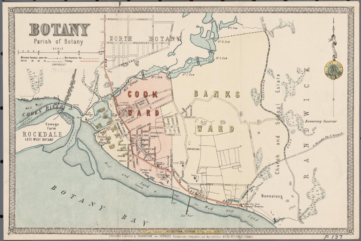
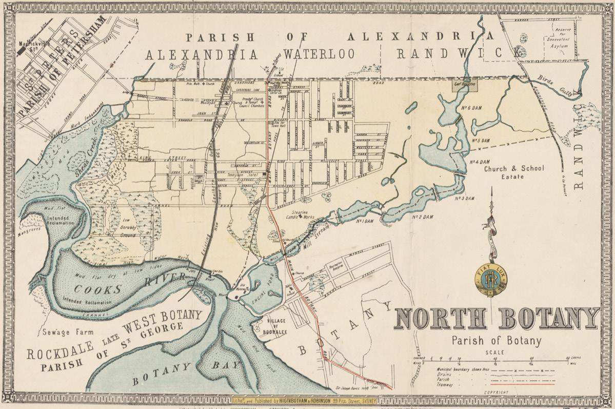
How well do you know your street?
Over time, streetscapes and landscapes have evolved. Can you locate your home, school, or old neighbourhood haunts on these maps from 1890? Did your street exist back then? Do you know the story behind your street name?
Browse our resources to uncover the meaning behind your streets name and see if you can locate your street on one of the estate maps.
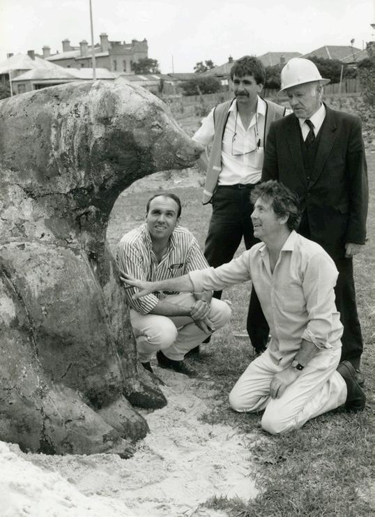
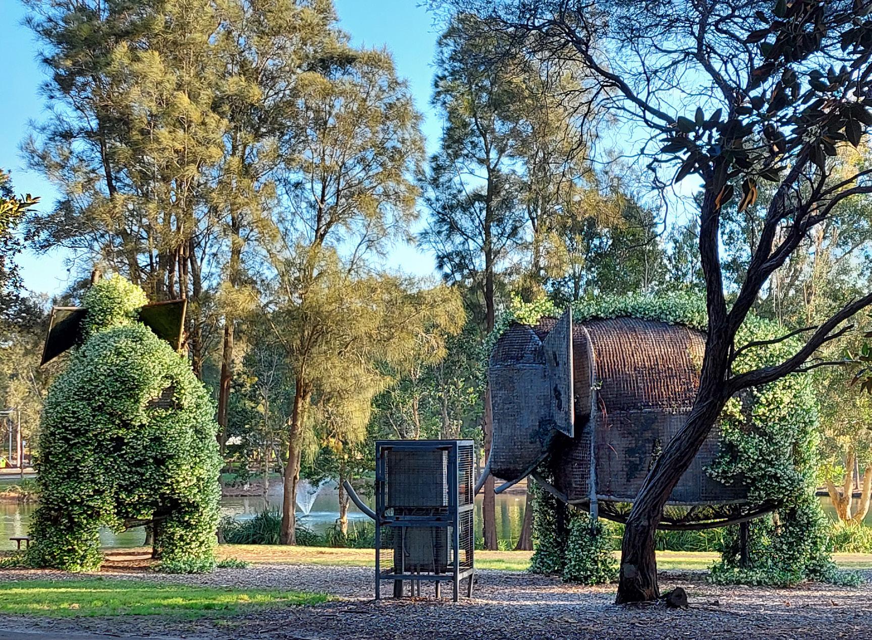
Would you believe that Australia’s first zoo was in Botany?
The Sir Joseph Banks Hotel is one of the oldest buildings in the City of Botany Bay. Opening in 1844 over its lifetime its grounds contained a fine dining hotel, amphitheater, ballroom and also Australia’s first zoo.
The zoo was established by William Beaumont and started operating almost 40 years prior to the Zoo at Moore Park (now Sydney Boys High School) which didn’t open until 1888. It housed a Bengal tiger, a black bear, an elephant, a grizzly bear, a red deer, goats and black Bengal sheep, along with numerous other fascinating and strange animals.
Originally, steps led down from the hotel and dining room to the extensive landscaped gardens, and the zoo. This area of the hotel and land reclaimed from Botany Bay are now within Sir Joseph Banks Park which was formed in the 1920s. The park includes various animal sculptures, remembering the long-ago zoo.
