Introduction
This Planning Proposal explains the intended effect of, and justification, for the proposed amendment to the Bayside Local Environmental Plan 2021 (BLEP 2021). It has been prepared in accordance with Section 3.33 of the Environmental Planning and Assessment Act 1979 (EPAA, 1979) and Local Environmental Plan Making Guideline (NSW Department of Planning & Environment, August 2023) (The Guideline)
The draft Planning Proposal (PP) for Signage in Zone SP2 Infrastructure is to amend the BLEP 2021 to allow ‘Signage’ as a use permissible with consent in Zone SP2 Infrastructure. This will affect all the land within Bayside Local Government Area (LGA) within this zone.
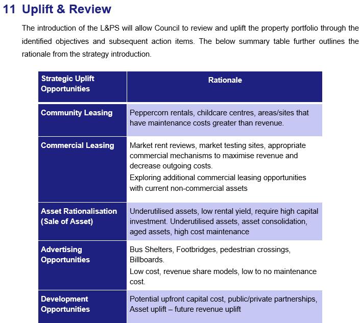
Council’s Land and Property Strategy (L&PS) identifies opportunities for Council to review and uplift its property portfolio. One of the uplift opportunities identified in the L&PS is advertising on footbridges and billboards.
On 27 March 2024, Council endorsed the recommendation prepared by Council’s Property team to take the required steps to accommodate advertising signs and structures on roadways at three (3) separate locations, including The Grand Parade, Wentworth Avenue and Foreshore Drive.
However, the advice received from the Department of Planning, Housing and Infrastructure (DPHI) in the covering letter (dated, 3 June 2024) issued for the PP-2023-1358 related to including an Additional Permitted Use (APU) for signage at Wentworth Avenue, Eastlakes, and the ongoing consultation regarding approaches for permissibility of signage on Classified Roads within the LGA allowed consideration of a broader approach to enable ‘Signage’ as a permitted use within the Zone SP2 Land Use Table Subsequently, alternative approaches were considered in accordance with the advice received from DPHI (Appendix A). These approaches included: applying APU (Signage) in Zone SP2 Infrastructure that is identified as ‘Classified Road’ only by inserting provisions in Schedule 1 of the BLEP 2021; or permitting signage with consent in all of the SP2 Infrastructure zone within the Land Use Table of the BLEP 2021. As a result, the draft PP now intends to permit Signage with consent in the Land Use Table for Zone SP2 Infrastructure. This will ensure certainty and orderly outcomes in the BLEP 2021.
An amendment to Bayside Development Control Plan 2022 (BDCP 2022) will be prepared as part of the housekeeping DCP to ensure it is consistent with the draft PP. This involves removing the control (Section 3.16.8, C1) which states third party advertising on public infrastructure is not permitted This control effectively prohibits advertising to be placed on public infrastructure and conflicts with the draft PP.
Background
Within the existing SP2 Infrastructure zone under the BLEP 2021, only the following uses are permissible:
Permitted without consent
Environmental protection works
Permitted with consent
Aquaculture; Roads; The purpose shown on the Land Zoning Map, including any development that is ordinarily incidental or ancillary to development for that purpose
Currently in the BLEP 2021, signage is prohibited in the SP2 Zone, and is only permissible in Zone RE1 Public Recreation. Signage was prohibited in the SP2 zone of both the repealed Rockdale LEP 2011 and Botany Bay LEP 2013. Roads were unzoned in the repealed Rockdale LEP 2000 and Botany Bay LEP 1995. Subsequently, signage may have been permitted based on merit assessment. Such sites with existing advertising structures for signage approved prior to the change of zoning operated under existing use rights and require modification to original consent under the SEPP (Industry and Employment) 2021 on expiration of 15 years after the date on which the consent becomes effective.
‘Building identification signs’ and ‘Business identification signs’ are currently permitted to be erected or installed in most of the zones within the Land Use Table. These signs can only allow the advertising of the person or business, nature of business, logo to identify the business, name of the building, and street name and number of a building. These signs cannot include third party general advertising of products, goods or services
To permit third party advertising signs, an amendment to the BLEP 2021 is proposed that identifies ‘Signage’, including Advertising Structures as a permissible use in the SP2 Infrastructure zone.
Council's Strategic Asset Management Committee undertook review of advertising opportunities on a number of potential sites within the LGA. These potential sites were presented to Council’s Strategic Property and Land Working Group (SPLWG) which informs the strategic direction for revenue opportunities, as a result three (3) sites on classified roads were selected.
Aligning with the L&PS, Council’s Property team presented a report to the Strategic Asset Management Committee on 6 February 2024 seeking support for Council to take the necessary steps in enabling advertising in selected location on road corridors within the SP2 zone.
At Bayside Council’s Ordinary Meeting on 27 March 2024, Council endorsed a recommendation prepared by Council’s Property team, which states:
3. Council takes the required steps to accommodate advertising signs and structures on roadways in the following locations:
a. Novotel footbridge, Grand Parade, Brighton Le Sands;
b. Wentworth Avenue east of Southern Cross Drive, Eastlakes;
c. Foreshore Drive between Hale Street and General Holmes Drive, Botany: including the preparation of a Planning Proposal under Part 3 of the Environmental Planning and Assessment Act 1979 to make signage permissible, or as required.
The original intent (as per Council’s resolution) was to insert an APU at selected locations on road corridors by inserting provisions in Schedule 1 of BLEP 2021. This included mapping the selected locations on the road reserve to indicate APU (Signage) land application. However, advice from DPHI and analysis of alternative approaches to permit signage with consent identified that permissibility in the SP2 Land Use Zone provides a refined and simpler approach than the APU. This will also streamline the planning approval pathway for installing Signage on SP2 land for any sites identified in the future instead of requiring a new PP process and amendment to LEP and mapping.
Other Councils in Greater Sydney have Signage as a permissible land use in the SP2 zone within their LEPs, such as Georges River, Blacktown, Cumberland and North Sydney (as APU).
Site Identification
The PP will amend BLEP 2021 to include ‘Signage’ as a use permissible with consent in Zone SP2 Infrastructure This will affect all land within this zone. The type of uses in the SP2 zone within the Land Zoning Map include Classified Road, Railway, Airport, Drainage, Depot, Defence, Sewerage System, Electricity Works, Telecommunications Facility and School.
Subject to approval of the PP, the assessment for signage in the SP2 zone would be merit-based and a Development Application (DA) would be required for signage proposed on each site. Proposed DAs submitted to Council would require assessment using the criteria in the SEPP (Industry and Employment) 2021 and the related Transport Corridor Outdoor Advertising and Signage Guidelines: Assessing Development Applications under SEPP 64 (NSW Department of Planning & Environment, November 2017) (TCOASG) as well as relevant controls in BLEP 2021 and BDCP 2022.
Further, the DA process would require preparation of technical studies to analyse potential impacts of signage on the subject sites Subject to planning controls and environmental constraints that apply to specific sites, the following technical documentation would be required to support any future DAs:
• Traffic
• Heritage
• Visual Impact
• Lighting Impact
• Biodiversity and Ecological Impact
• Aviation Safety
Land Required for Acquisition – F6 Transport Corridor Reservation
An analysis of ownership of land zoned SP2 was conducted to identify overall impacts in relation to the number of lots affected and the type of owners, including government authorities and private landowners The lots owned by TfNSW allow Signage as Exempt Development under SEPP (Industry and Employment) 2021. Section 3.14 Transport corridor land of the SEPP permits the display of an advertisement on transport corridor land with development consent on behalf of Transport for NSW (TfNSW)
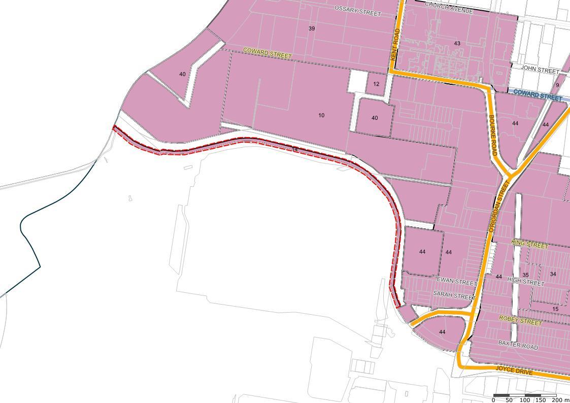
The Bayside LGA contains the F6 Transport Corridor Reservation, which spans from Campbell Road to Princes Highway, Loftus. Parts of the F6 Transport Corridor Reservation have been acquired for the construction of the WestConnex, Sydney Gateway and M6 Stage 1. The large remainder of the reservation remains in place including properties in private ownership TfNSW have advised Council on the status of the remainder of the reservation in a letter dated 27 November 2024 (Appendix B) TfNSW advises the remainder of the privately owned land zoned SP2 still remains in place and refers to the NSW Urban Transport Statement released in December 2016 which outlines “The Government has decided to retain the corridor to provide capacity for possible future transport use and/or open space. Such uses could include a road, a busway, a cycleway, light rail/or heavy rail”
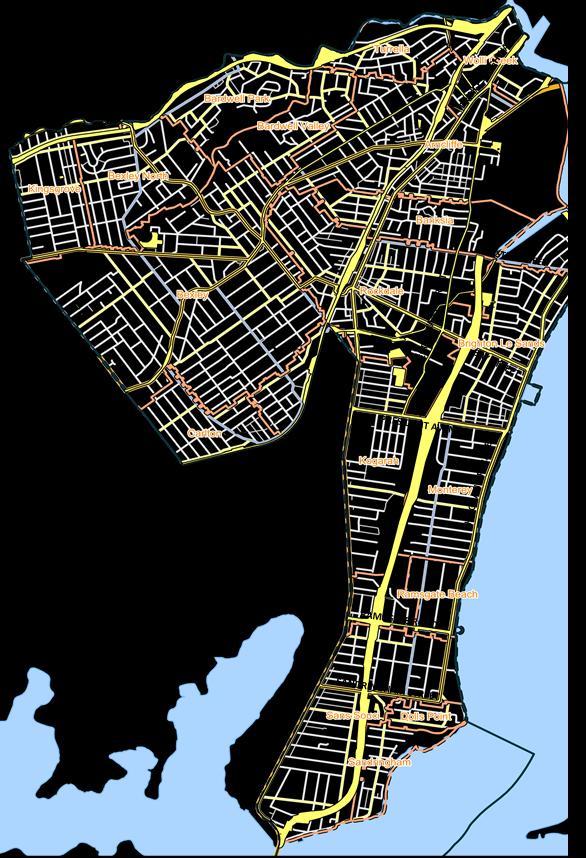
The impact of the draft PP on properties zoned SP2 (Figure 1) in private ownership is considered to be minimal given the reservation status will be retained.
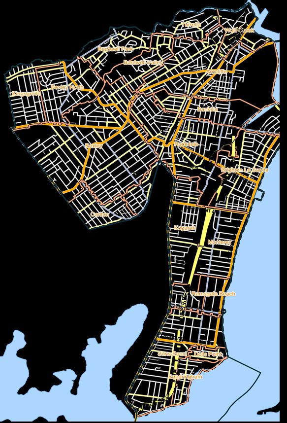
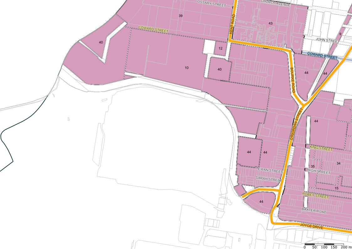
Furthermore, the DA process would be in place to manage any development proposal Council receives for signage on land in private ownership. A Land Required for Acquisition (LRA) layer applies to lots in private ownership that are zoned SP2 (Figure 2), this will provide an additional level of protection to prohibit signage from being proposed on such lots Development on LRA land will be subject to Clause 5.1 of the BLEP 2021 which ensures development is only granted for Classified Road purposes.
The BDCP 2022 contains relevant controls for signs and advertising when considering applications for signage, and relevant amendments will be made to the BDCP 2022 to ensure it is consistent with the draft PP
Figure 1: SP2 Zone (in yellow) - M6 Road Corridor (Source: IntraMaps)
Figure 2: Properties Affected by LRA (in yellow) - M6 Road Corridor (Source: IntraMaps)
Existing Signage in Bayside LGA
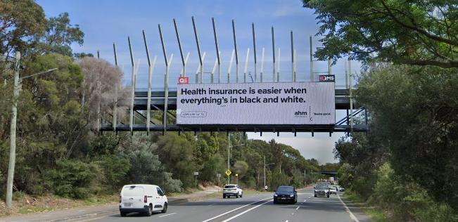
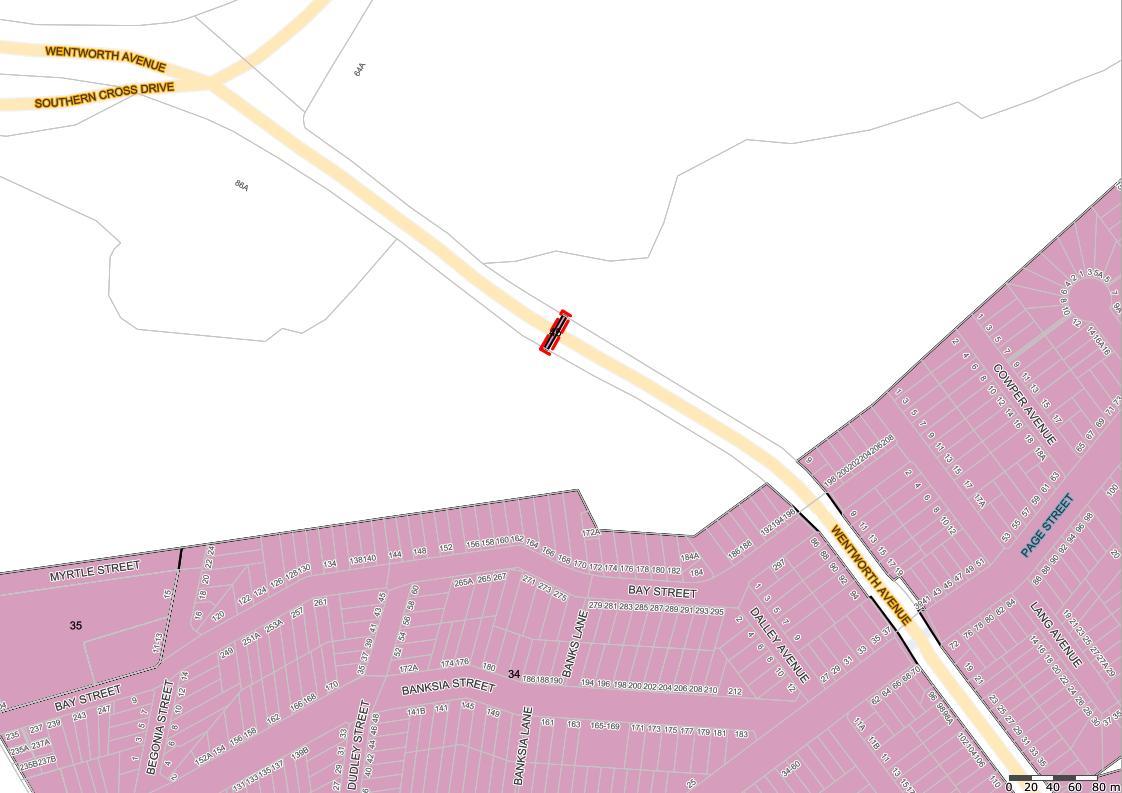
Bayside LGA has existing advertising structures and signage on road corridors within the SP2 zone. Refer to examples in Figures 3 - 6
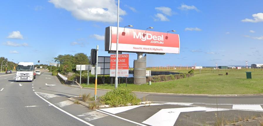
Figure 3: Advertising double digital signage on land occupied by the pedestrian bridge on Wentworth Avenue, Eastlakes (Source: Google Maps)
Figure 4: Freestanding double static advertising structure on Foreshore Road, Botany (Source: Google Maps)
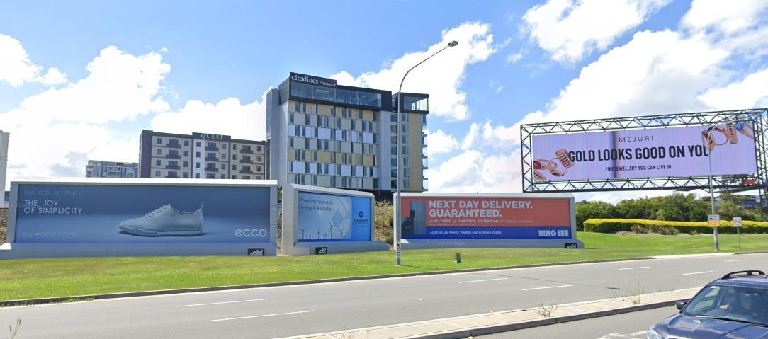
Figure 5: Static and digital freestanding advertising signage on Joyce Drive, Mascot (Source: Google Maps)
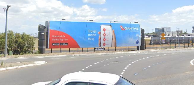
Figure 6: Freestanding digital advertising signage on General Holmes Drive, facing traffic on Mill Pond Road, Mascot (Source: Google Maps)
Part 2 – Explanation of Provisions
The intended outcomes will be achieved by permitting advertising signage with consent in the Zone SP2 Infrastructure Land Use Table within the BLEP 2021.
Bayside LEP 2021
The Standard Instrument and BLEP 2021 includes the following relevant definitions:
Signage–
signage means any sign, notice, device, representation or advertisement that advertises or promotes any goods, services or events and any structure or vessel that is principally designed for, or that is used for, the display of signage, and includes any of the following
(a) an advertising structure,
(b) a building identification sign,
(c) a business identification sign, but does not include a traffic sign or traffic control facilities.
Advertising structure is a type of signage–advertising structure has the same meaning as in the Act.
Note—
The term is defined as a structure used or to be used principally for the display of an advertisement.
Advertising structures are a type of signage
The amendment would allow signage, including advertising structures, with consent in the SP2 zone. The amended SP2 zone Land Use Table in the BLEP 2021 is shown below (red text represents an insertion):
Zone SP2 Infrastructure
1 Objectives of zone
• To provide for infrastructure and related uses.
• To prevent development that is not compatible with or that may detract from the provision of infrastructure.
2 Permitted without consent
Environmental protection works
3 Permitted with consent
Aquaculture; Roads; Signage; The purpose shown on the Land Zoning Map, including any development that is ordinarily incidental or ancillary to development for that purpose
4 Prohibited
Any development not specified in item 2 or 3
Additional Permitted Uses (APU)
Under Clause 2.5 and Schedule 1 of the Bayside LEP 2021, ‘Signage’ is permitted as an Additional Permitted Use (APUs) on the following sites zoned SP2, including:
• Clause 18 Use of certain land along Qantas Drive, Mascot
• Clause 45 Use of certain land at Wentworth Avenue, Eastlakes
The Planning Proposal will make these APUs redundant and the following amendments to the BLEP 2021 are required:
• Amend Schedule 1 of the Bayside LEP 2021 by deleting items 18 and 45, which state:
18 Use of certain land along Qantas Drive, Mascot
(1) This clause applies to the following land adjacent to Qantas Drive, Mascot, identified as “14” on the Additional Permitted Uses Map
(a) Part Lot 95, DP 1157632, (b) Part Lot 11, DP 213317, (c) Lot 17, DP 217443, (d) Lot 6, DP 209847, (e) Part Lot 9, DP 747022.
(2) Development for the purposes of signage is permitted with development consent.
45 Use of certain land at Wentworth Avenue, Eastlakes
(1) This clause applies to land identified as “45” on the Additional Permitted Uses Map
(2) Development for the purposes of signage is permitted with development consent.
• Amend Additional Permitted Uses (APU) Map to delete land identified as 14 and 45.
Consistency with SEPP (Industry and Employment) 2021
Chapter 3 Advertising and signage of the SEPP (Industry and Employment) 2021 is relevant to the draft PP
This SEPP seeks to achieve the following key aims and objectives:
(a) to ensure that signage (including advertising)
(i) is compatible with the desired amenity and visual character of an area, and (ii) provides effective communication in suitable locations, and (iii) is of high quality design and finish, and (b) to regulate signage (but not content) under Part 4 of the Act, and (c) to provide time-limited consents for the display of certain advertisements, and (d) to regulate the display of advertisements in transport corridors, and (e) to ensure that public benefits may be derived from advertising in and adjacent to transport corridors.
Section 3.14 Transport corridor land of the SEPP (Industry and Employment) 2021 allows State authorities to have increased statutory authority to place advertising signage with development consent within transport corridors, such as road corridors and railway corridors, as follows:
(a) the display of an advertisement by or on behalf of RailCorp, NSW Trains, Sydney Trains, Sydney Metro or TfNSW on a railway corridor,
(b) the display of an advertisement by or on behalf of TfNSW on
(i) a road that is a freeway or tollway (under the Roads Act 1993) or associated road use land that is adjacent to such a road, or
(ii) a bridge constructed by or on behalf of TfNSW on any road corridor, or (iii) land that is owned, occupied or managed by TfNSW and that is within 250 metres of a classified road,
(c) the display of an advertisement on transport corridor land comprising a road known as the Sydney Harbour Tunnel, the Eastern Distributor, the M2 Motorway, the M4 Motorway, the M5 Motorway, the M7 Motorway, the Cross City Tunnel or the Lane Cove Tunnel, or associated road use land that is adjacent to such a road.
Council is subject to requirements under Section 3.8 Prohibited advertisements of SEPP which prohibit advertising signage in certain locations within any of the following zones or descriptions:
environmentally sensitive area
heritage area (excluding railway stations)
natural or other conservation area
open space
waterway
residential (but not including a mixed residential and business zone, or similar zones)
scenic protection area
national park nature reserve
All signage which is visible from a classified road and is not identified as either exempt or prohibited, requires development consent under the SEPP. The SEPP outlines the consent authority for different types of signage
which can be Council, TfNSW or the Minister for Planning. The Minister for Planning is generally the consent authority for advertising by or on behalf of State authorities within major transport corridors or on land that is owned, occupied or managed by TfNSW
The SEPP (Industry and Employment) 2021 includes specific requirements for signs of certain sizes and heights, and also for freestanding advertisements and signs on bridges. The consent authority is required to ensure the advertisement or the advertising structure must be consistent with the objectives of the SEPP, Schedule 5 Assessment criteria of the SEPP, and satisfy the criteria within TCOASG. This also includes signage to be acceptable in terms of design, road safety, and public benefits provided in connection with the display of the advertisement.
The TCOASG underpin the SEPP (Industry and Employment) 2021 in the assessment of DAs. This outlines the land use compatibility criteria that guides third party advertisements in any given locality. The criteria also notes that structures should not be located so as to diminish the heritage values of items or areas of local, regional or state heritage significance.
The draft PP does not contain provisions that contradict or hinder the application of the SEPP. Any future DA would be required to comply with the requirements in the SEPP and be consistent with the assessment criteria contained within TCOASG.
As part of the detailed DA assessment process, the sites affected by land use constraints may require several specialist reports including traffic safety, visual impact, biodiversity and heritage which will demonstrate the impacts of future development. Such requirements will be documented at the DA stage.
Given the draft PP impacts all the SP2 zoned land, TfNSW and Sydney Airport will be consulted on the proposal regarding signage, driver safety and aviation safety during the post-Gateway stage, in accordance with the Gateway conditions, subject to approval.
B - Relationship to strategic planning framework
Q3 - Will the Planning Proposal give effect to the objectives and actions of the applicable regional or district plan or strategy (including any exhibited draft plans or strategies)?
GREATER SYDNEY REGIONAL PLAN
The draft Planning Proposal is consistent with the objectives and actions of the Greater Sydney Region Plan: A Metropolis of Three Cities (GSRP). Table 1 below provides an assessment of this draft PP against the GSRP:
Table 1 - Consistency with Greater Sydney Regional Plan (GSRP)
Directions
5. A city of great places
Objective 12: Great Places bring people together.
Comment: The proposal seeks to permit Signage with development consent in the Zone SP2 Infrastructure Land Use Table and will be subject to provisions that will ensure advertisements are of high quality, respects our community’s commitment to heritage conservation and maintains the amenity of the LGA.
Yes
Directions Comment
Objective 13: Environmental heritage is conserved and enhanced.
Comment: The proposal seeks to permit Signage with development consent in the Zone SP2 Infrastructure Land Use Table. Any future DA for signage on a heritage land or in vicinity of a heritage item will be subject to heritage impact assessment under Clause 5.10 Heritage conservation of the BLEP 2021. Additionally, relevant standards in the SEPP (Industry and Employment) 2021 and TCOASG will ensure no adverse impacts on heritage items or heritage conservation areas. This ensures environmental heritage is protected.
Sustainability
8. A city in landscape
Objective 25: The coast and waterways are protected and healthier.
Comment: The proposal seeks to permit Signage with development consent in the Zone SP2 Infrastructure Land Use Table. Any future DA for signage will be subject to Clause 6.5 Riparian land, wetland and waterways of BLEP 2021. This ensures to porrect environmentally sensitive areas of waterways and riparian land.
Objective 27: Biodiversity is protected, urban bushland and remnant vegetation is enhanced.
Comment: The proposal seeks to permit Signage with development consent in the Zone SP2 Infrastructure Land Use Table. Any future DA for signage will be subject to Clause 6.4 Terrestrial biodiversity of BLEP 2021. This ensures protection of biodiversity corridors and native fauna and flora.
EASTERN CITY DISTRICT PLAN
Yes
Yes
The Eastern City District Plan (ECDP) identifies a range of planning priorities for the District, in line with the four categories identified in the Greater Sydney Region Plan:
• Infrastructure and collaboration;
• Liveability;
• Productivity; and
• Sustainability.
The draft PP’s consistency with the priorities in the ECDP are discussed in further detail in Table 2 below:
Table 2 - Consistency with the Eastern City District Plan (ECDP)
Infrastructure and Collaboration
E1 Planning for a city supported by infrastructure.
Comment: Permitting Signage with development consent in the Zone SP2 Infrastructure will provide an opportunity to increase Council’s revenue which will support placemaking initiatives and infrastructure provision in the LGA. To ensure that this is undertaken appropriately, the proposed amendment will require signage to be carried out through the DA pathway and will be subject to provisions that will ensure that signages are of a high quality, respects our community’s commitment to heritage conservation and maintains the amenity of the LGA.
Liveability
E3 Providing services and social infrastructure to meet people’s changing needs.
Comment: Permitting Signage with development consent in the Zone SP2 Infrastructure will provide an opportunity to increase Council’s revenue which will support placemaking initiatives and infrastructure provision in the LGA. To ensure that this is undertaken appropriately, the proposed amendment will require signage to be carried out through the DA pathway and will be subject to provisions that will ensure that signages are of a high quality, respects our community’s commitment to heritage conservation and maintains the amenity of the LGA.
E6 Creating and renewing great places and local centres, and respecting the District’s heritage.
Comment: The proposal seeks to permit Signage with development consent in the Zone SP2 Infrastructure Land Use Table. Any future DA for signage on a heritage land or in vicinity of a heritage item will be subject to heritage impact assessment under Clause 5.10 Heritage conservation of BLEP 2021. This ensures environmental heritage is protected.
Sustainability
E14 Protecting and improving the health and enjoyment of Sydney Harbour and the District’s waterways
Comment: The proposal does not alter the existing riparian land, wetlands and waterways provisions within BLEP 2021, which will apply to any future DAs for signage in the SP2 zone The related provisions in the SEPP (Resilience and Hazards) 2021 regarding coastal management will be considered at the DA stage for land that is identified as coastal wetland or affected by coastal wetlands proximity area. Although, the nature of LEP amendment is unlikely to affect coastal management.
In addition, relevant standards in the SEPP (Industry and Employment) 2021 and TCOASG will ensure no adverse impacts on environmentally sensitive areas and waterways. Given this, the requirements of the Planning Priority are satisfied to facilitate protection and management of coastal areas. Yes
E15 Protecting and enhancing bushland and biodiversity.
Comment: The proposal does not alter the existing terrestrial biodiversity provisions within BLEP 2021, which will apply to any future DAs for signage in the SP2 zone Relevant standards in the SEPP (Industry and Employment) 2021 and TCOASG will ensure no adverse impacts on environmentally sensitive areas and open space. Given this, the requirements of the Planning Priority are satisfied to facilitate protection of bushland.
E16 Protecting and enhancing scenic and cultural landscapes.
Comment: Any future DAs for signage in the SP2 zone will require consideration of any significant vistas or views that contribute to the character of the area Based on the location of a proposed site for advertising signage, additional studies related to a Visual Impact Assessment may be required at the DA stage.
Yes
Yes
Q4 - Is the Planning Proposal consistent with a Council LSPS that has been endorsed by the Planning Secretary or GCC, or another endorsed local strategy or strategic plan?
BAYSIDE LOCAL STRATEGIC PLANNING STATEMENT – A LAND USE VISION TO 2036
Council has adopted the Bayside Local Strategic Planning Statement (LSPS) in accordance with the guidance provided by DPHI. Council has aligned the Bayside LSPS Priorities to the Greater Sydney Region Plan – A Metropolis of Three Cities (GSRP), the Planning Priorities in the Eastern City District Plan as well as Councils Community Strategic Plan.
Table 3 - Consistency with Bayside Local Strategic Planning Statement (LSPS)
Infrastructure and Collaboration
B2 Align land use planning with the delivery and management of assets by Bayside Council to support our community.
LSPS Action: Council will take a place based approach to land use and asset planning to ensure growth aligns with infrastructure provision
Comment: The draft PP aligns with the Council's L&PS to identify opportunities for increased revenue through advertising. Permitting Signage with development consent in the Zone SP2 Infrastructure will provide an opportunity to increase Council’s revenue which will support placemaking initiatives and infrastructure provision in the LGA. To ensure that this is undertaken appropriately, the proposed amendment will require signage to be carried out through the DA pathway and will be subject to provisions that will ensure that signages are of a high quality, respects our community’s commitment to heritage conservation and maintains the amenity of the LGA. Yes
Liveability
B9 Manage and enhance the distinctive character of the LGA through good quality urban design, respect for existing character and enhancements of the public realm.
LSPS Action: Update planning controls for Bayside DCP 2020 to give clearer guidance to applicants and their architects about Council’s expectations for high standards of design.
Comment: Any future signage structure will be required to achieve consistency with the standard DA assessment process for the proposed use of advertising signage. The SEPP (Industry and Employment) 2021 and TCOASG include requirement for design criteria for signage in transport corridors Section 3.16 Signs and Advertising of the BDCP 2022 contains objectives and controls related to signage will continue to apply to the nominated and proposed sites for advertising structures, ensuring good built form outcomes
B10 Value, protect and conserve Aboriginal heritage.
LSPS Action: Council will protect, celebrate and promote Bayside’s rich Aboriginal cultural heritage.
Comment: Appropriate controls for conservation and maintenance of heritage values will be applied at the future DA stage for signage in the SP2 zone. Relevant standards in the SEPP (Industry and Employment) 2021 and TCOASG will ensure no adverse impacts on heritage items or heritage conservation areas.
Yes
Yes
B11 Develop clear and appropriate controls for development of heritage items, adjoining sites and within conservation areas.
LSPS Action: Council will protect, celebrate and promote Bayside’s rich cultural heritage.
Comment: Appropriate controls for conservation and maintenance of heritage values will be applied at the future DA stage for signage in the SP2 zone. Relevant standards in the SEPP (Industry and Employment) 2021 and TCOASG will ensure no adverse impacts on heritage items or heritage conservation areas.
BAYSIDE COMMUNITY STRATEGIC PLAN 2018-2032
The Bayside Community Strategic Plan 2018-2032 (which superseded the Rockdale City Community Strategic Plan) sets the strategic direction for Council’s Delivery Program and Operational Plans. The themes and directions outlined in this plan inform Council’s Delivery Program and the annual Operational Plans that describe Council’s activities towards achieving those outcomes in the Delivery Program.
Theme One – In 2032 Bayside will be a vibrant place
1.4 Bayside’s transport system works Strategies:
1.4.1 Promote adequate, accessible, reliable public transport for ease of travel to work and leisure.
1.4.3 Support an effective and efficient local road network through investment in maintenance and reduced traffic issues in Bayside.
Comment: Permitting Signage with development consent in the Zone SP2 Infrastructure will provide an opportunity to increase Council’s revenue which will support placemaking initiatives and infrastructure provision in the LGA. To ensure that this is undertaken appropriately, the proposed amendment will require signage to be carried out through the DA pathway and will be subject to provisions that will ensure that signages are of a high quality, respects our community’s commitment to heritage conservation and maintains the amenity of the LGA.
Theme Four – In 2032 Bayside will be a prosperous community
4.3 Council is financially sustainable and well governed
Strategies:
4.3.4 Manage Council assets to meet community expectations within available resources
4.3.5 Manage Council finances for the long-term benefit of the community and to prioritise infrastructure funding commitments.
Comment: Permitting Signage with development consent in the Zone SP2 Infrastructure will provide an opportunity to increase Council’s revenue which will support placemaking initiatives and infrastructure provision in the LGA. To ensure that this is undertaken appropriately, the proposed amendment will require signage to be carried out through the DA pathway and will be subject to provisions
Yes
Yes
Table 4 - Consistency with the Bayside Council Community Strategic Plan (CSP)
Community Outcome Strategies
that will ensure that signages are of a high quality, respects our community’s commitment to heritage conservation and maintains the amenity of the LGA.
BAYSIDE LOCAL HOUSING STRATEGY
Consistency
The purpose of the Bayside Local Housing Strategy (Bayside LHS) is to set the strategic framework and vision for housing in the Bayside LGA up to 2036.
The Bayside LHS has been prepared in accordance with the NSW Government Local Housing Strategy Guidelines and Template (2018) and the requirements of the Greater Sydney Region Plan: A Metropolis of Three Cities (2018) and its Eastern City District Plan (2018).
Due to the nature of the proposed amendment to the BLEP 2021, the objectives in the Bayside LHS will not be applicable to the proposal to make Signage a use permissible with consent in the SP2 zone
Q5 - Is the Planning Proposal consistent with any other applicable State and regional studies or strategies?
FUTURE TRANSPORT STRATEGY 2056
The Future Transport Strategy 2056 identifies six guiding principles for the NSW public transport system, identified below.
1. Customer Focused;
2. Successful Places;
3. A Strong Economy;
4. Safety and Performance;
5. Accessible Services; and
6. Sustainability.
Whilst the proposal does not affect the public transport system directly, it will facilitate investments in traffic safety, amenity improvements or other public works funded by the revenue raised from outdoor advertising. Improvements to traffic safety for drivers, pedestrians and cyclists are a priority for expenditure. This may include works such as improvising bicycle rider safety installation of pedestrian refuges, bus shelters/seats, safety and navigation signage, speed calming devices, new and upgraded footpath, safety devices (e.g. raised pedestrian crossings or signals).
The proposal could lead to initiatives that develop specific placemaking projects aimed at improving the overall experience for public transport users. As such, the proposal is consistent with the guiding principles of customer focused, a strong economy, safety and performance and accessible services.
NSW STATE INFRASTRUCTURE STRATEGY 2018-2038
The NSW State Infrastructure Strategy 2018-2038 (SIS) sets out the government’s priorities for the next 20 years and combined with the Future Transport Strategy 2056, the Greater Sydney Region Plan and the Regional Development Framework, brings together infrastructure investment and land-use planning for our cities and regions. The SIS looks beyond the current projects and identifies policies and strategies needed to provide the infrastructure that meets the needs of a growing population and a growing economy.
The Strategy sets out six overarching strategic directions to instil best practice approaches across NSW's infrastructure sectors:
• Continuously improve the integration of land and infrastructure planning;
• Plan, prioritise and deliver an infrastructure program that represents the best possible investment and use of public funds;
• Optimise the management, performance and use of the State’s assets;
• Ensure NSW’s existing and future infrastructure is resilient to natural hazards and human-related threats;
• Improve state-wide connectivity and realise the benefits of technology; and
• Drive high quality consumer-centric services and expand innovative service delivery models in infrastructure sectors.
This draft PP is consistent with the objectives of the NSW State Infrastructure Strategy.
Q6
- Is the Planning Proposal consistent with applicable SEPPs?
Consistency with the State Environmental Planning Policies is provided in Table 5 below:
Table 5 - Consistency with SEPPs
Planning Policy (SEPP)
(Transport and Infrastructure) 2021
(Biodiversity and Conservation) 2021
The SEPP covers planning and delivery of infrastructure
Any future DA for an advertising structure will be subject to relevant technical studies These studies will include Traffic and Road Safety Assessment and Lighting Impact Assessment, considering site characteristics, driver safety and crash analysis.
TfNSW will be consulted on the proposal regarding advertising signage and driver safety during the post-Gateway stage Overall, the PP does not impact upon the operation of this SEPP.
The SEPP covers biodiversity and preservation of trees and vegetation in non-rural areas
Given the nature of the proposed amendment, it is unlikely that future development will conflict with provisions of the SEPP. If the proposed sites in future applications are located on or in close proximity to vegetation identified in the SEPP Land Application Maps, issues pertaining to biodiversity and tree management can be satisfactorily addressed at the DA stage, in accordance with the requirements of Chapter 2 Vegetation in non-rural areas of the SEPP.
Yes
(Resilience and Hazards) 2021
The SEPP covers coastal management and hazardous or offensive development.
Given the nature of the proposed amendment, it is unlikely that future development will conflict with provisions of the SEPP. Subject to the specific site located on land identified as “proximity area for coastal wetlands” or “proximity area for littoral rainforest” on the Coastal Wetlands and Littoral Rainforests Area Map, any future DA will be assessed in accordance with the requirements of Chapter 2 Coastal management of the SEPP.
(Industry and Employment) 2021
The SEPP aims to ensure that outdoor advertising is compatible with desired amenity and visual character of an area, provides effective communication in suitable location and is of high quality and finish. Chapter 3 Advertising and signage of the SEPP is relevant to the draft PP
The PP is generally consistent with the aims, objectives and provisions of the SEPP, and does not introduce any potential land use conflicts. Any potential adverse impacts would be managed by the planning controls in the SEPP. Refer to ‘Consistency with SEPP (Industry and Employment) 2021’ section in Part 2 – Explanation of Provisions of this Report.
State Environmental Planning Policy (SEPP)
(Exempt and Complying Development Codes) 2008
The proposal does not conflict with SEPP (Exempt and Complying Development Controls) 2008 provisions. Advertising signage is not permitted in the SP2 Infrastructure zone, hence Signage is proposed as a use permitted with consent in the SP2 Land Use Table.
Yes
Q7 - Is the Planning Proposal consistent with applicable Ministerial Directions (section 9.1 Directions) or key government priorities?
Table 6 below reviews the consistency of the draft Planning Proposal with the Local Planning Directions for LEPs under section 9.1 (formerly section 117 Ministerial Directions) of the Environmental Planning and Assessment Act 1979
Table 6 - Consistency with Section 9.1 Ministerial Directions
Focus Area 1: Planning Systems
1.1 Implementation of Regional Plans
Objective: To give legal effect to the vision, land use strategy, goals, directions and actions contained in Regional Plans.
Comment: The draft PP is consistent with the Greater Sydney Region Plan as demonstrated in Section B – Question 3 of this Report.
Yes
1.2 Development of Aboriginal Land Council land
1.3 Approval and Referral Requirements
Objective: To provide for the consideration of development delivery plans prepared under chapter 3 of the State Environmental Planning Policy (Planning Systems) 2021 when Planning Proposals are prepared by a Planning Proposal Authority.
Comment: Does not apply to this proposal.
Objective: To ensure that LEP provisions encourage the efficient and appropriate assessment of development.
Comment: The proposal allows the most efficient approval pathway to permit signage with development consent on land zoned SP2 Any future development of signage would be subject to the DA process on each site, requiring compliance with LEP provisions.
N/A
1.4 Site Specific Provisions
Objective: To discourage unnecessarily restrictive site-specific planning controls.
Comment: The proposal simplifies and streamlines the approval process to allow land use for signage to be carried out with development consent in the SP2 zoned land by including Signage in the Land Use Table.
Yes
Yes
1.4A Exclusion of Development Standards from Variation
Objective: To maintain flexibility in the application of development standards by ensuring that exclusions from the application of clause 4.6 of a Standard Instrument Local Environmental Plan (Standard Instrument LEP) or an equivalent provision of any other environmental planning instrument, are only applied in limited circumstances.
Comment: Does not apply to this proposal.
N/A
Ministerial Direction Comment
Focus Area 1: Planning Systems –
1.11 Implementation of Bayside West Precincts 2036 Plan
1.12 Implementation of Planning Principles for the Cooks Cove Precinct
Place-based
Objective: To ensure development within the Bayside West Precincts (Arncliffe, Banksia and Cooks Cove) is consistent with the Bayside West Precincts 2036 Plan.
Comment: Does not apply to this proposal. N/A
Objective: To ensure development within the Cooks Cove Precinct is consistent with the Cooks Cove Planning Principles.
Comment: Does not apply to this proposal.
Focus Area 3: Biodiversity and Conservation
3.1 Conservation Zones Objective: To protect and conserve environmentally sensitive areas.
Comment: Does not apply to this proposal. N/A
3.2 Heritage Conservation Objective: To conserve items, areas, objects and places of environmental heritage significance and indigenous heritage significance.
Comment: The proposal does not alter the existing heritage conservation provisions within BLEP 2021, which will apply to any future DAs for signage in the SP2 zone. Relevant standards in the SEPP (Industry and Employment) 2021 and TCOASG will ensure no adverse impacts on heritage items or heritage conservation areas. Given this, the requirements of the Direction are satisfied to facilitate heritage conservation
Yes
3.5 Recreation Vehicle Areas
3.6 Strategic Conservation Planning
3.7 Public Bushland
Objective: To protect sensitive land or land with significant conservation values from adverse impacts from recreation vehicles.
Comment: Does not apply to this proposal. N/A
Objective: To protect, conserve or enhance areas with high biodiversity value.
Comment: Does not apply to this proposal. N/A
Objective: To protect bushland in urban areas, including rehabilitated areas, and ensure the ecological viability of the bushland.
Comment: The proposal does not alter the existing terrestrial biodiversity, and riparian land, wetlands and waterways provisions within BLEP 2021, which will apply to any future DAs for signage in the SP2 zone Relevant standards in the SEPP (Industry and Employment) 2021 and TCOASG will ensure no adverse impacts on environmentally sensitive areas, waterways and open space. Given this, the requirements of the Direction are satisfied to facilitate protection of bushland
Yes
3.10 Water Catchment Protection
Objective: To:
(a) Maintain and improve the water quality (including ground water) and flows of natural waterbodies, and reduce urban run-off and stormwater pollution;
(b) Protect and improve the hydrological, ecological and geomorphological processes of natural waterbodies and their connectivity;
N/A
Ministerial
(c) Protect and enhance the environmental quality of water catchments by managing them in an ecologically and sustainable manner, for the benefit of all users; and
(d) Protect, maintain and rehabilitate watercourses, wetlands, riparian lands and their vegetation and ecological connectivity.
Comment: Does not apply to this proposal.
Focus Area 4: Resilience and Hazards
4.1 Flooding Objective: To:
(a) Ensure that development of flood prone land is consistent with the NSW Government’s Flood Prone Land Policy and the principles of the Floodplain Development Manual 2005, and
(b) Ensure that the provisions of an LEP that apply to flood prone land are commensurate with flood behaviour and includes consideration of the potential flood impacts both on and off the subject land.
Comment: Does not apply to this proposal.
4.2 Coastal Management
Objective: To protect and manage coastal areas of NSW.
Comment: The proposal does not alter the existing riparian land, wetlands and waterways provisions within BLEP 2021, which will apply to any future DAs for signage in the SP2 zone The related provisions in the SEPP (Resilience and Hazards) 2021 regarding coastal management will be considered at the DA stage for land that is identified as coastal wetland or affected by coastal wetlands proximity area Although, the nature of LEP amendment is unlikely to affect coastal management.
In addition, relevant standards in the SEPP (Industry and Employment) 2021 and TCOASG will ensure no adverse impacts on environmentally sensitive areas and waterways. Given this, the requirements of the Direction are satisfied to facilitate protection and management of coastal areas.
4.4 Remediation of Contaminated Land Objective: To reduce the risk of harm to human health and the environment by ensuring that contamination and remediation are considered by Planning Proposal Authorities.
Comment: Does not apply to this proposal. N/A
4.5 Acid Sulfate Soils
Objective: To avoid significant adverse environmental impacts from the use of land that has a probability of containing acid sulfate soils.
Comment:
The nature of development - being signage - is unlikely to disturb, expose or drain acid sulfate soils and cause environmental damage from the excavation works involved. Notwithstanding, the proposal does not alter the existing acid sulfate soils provisions within BLEP 2021, any significant adverse environmental impacts can be assessed during the DA stage
Focus Area 5: Transport and Infrastructure
5.1 Integrating Land Use and Transport
Objective: To ensure that urban structures, building forms, land use locations, development designs, subdivision and street layouts achieve the following planning objectives:
Yes
Ministerial Direction Comment Consistency
(a) Improving access to housing, jobs and services by walking, cycling and public transport, and
(b) Increasing the choice of available transport and reducing dependence on cars, and
(c) Reducing travel demand including the number of trips generated by development and the distances travelled, especially by car, and
(d) Supporting the efficient and viable operation of public transport services, and
(e) Providing for the efficient movement of freight.
Comment: The proposal does not adversely impact the existing land use and transport. Permitting Signage with development consent in the Zone SP2 Infrastructure will provide an opportunity to increase Council’s revenue which will support placemaking initiatives and infrastructure provision in the LGA. This will support the investment of traffic safety, amenity improvements or other public works.
To ensure that the initiatives are undertaken appropriately, the proposed amendment will require signage to be carried out through the DA pathway and will be subject to provisions that will ensure that signages are of a high quality, respects our community’s commitment to heritage conservation and maintains the amenity of the LGA.
5.2 Reserving Land for Public Purposes
Objective: To:
(a) facilitate the provision of public services and facilities by reserving land for public purposes, and
(b) facilitate the removal of reservations of land for public purposes where the land is no longer required for acquisition.
Comment: The proposal will impact the land affected by LRA in the BLEP 2021. This LRA is related to the F6 Transport Corridor Reservation. TfNSW advice that the remainder of the reservation remains in place including properties in private ownership. Therefore, the impact of the draft PP on properties zoned SP2 (Figure 1) in private ownership is considered to be minimal given the reservation status will be retained.
The proposal does not alter the existing provisions related to development on land intended to be acquired for public purposes within the BLEP 2021 This will restrict signage from being proposed on such lots during the DA stage
5.3 Development Near Regulated Airports and Defence Airfields
Objective: To:
(a) Ensure the effective and sage operation of regulated airports and defence airfields;
(b) Ensure that their operation is not compromised by development that constitutes an obstruction, hazard or potential hazard to aircraft flying in the vicinity; and
(c) Ensure development, if situated on noise sensitive land, incorporates appropriate mitigation measures so that the development is not adversely affected by aircraft noise.
Comment: The nature of development - being signage, (including an advertising structure, such as a freestanding advertisement, and
Ministerial Direction Comment Consistency
advertisements on bridges) will be subject to airspace operations provisions in the BLEP 2021. This ensures any adverse impacts on airspace operations from the proposed height of advertisement structures are addressed through the DA process.
Relevant concurrence will be required from Civil Aviation Safety Authority (CASA) and Sydney Airport if the height of structures does not comply with the Civil Aviation (Buildings Control) Regulations which limit the height of structures above existing ground height (AEGH), and Obstacle Limitation Surface (OLS) which limit the height to a maximum Reduced Level (RL) above Australian Height Datum (AHD)
5.5 High Pressure Dangerous Goods Pipelines
Objective: To reduce the risk of harm to human health and the environment by ensuring high pressure dangerous goods pipelines (relevant pipelines) are considered by planning proposal authorities.
Comment: Parts of Bayside LGA, including the SP2 zone, are within the zone of influence of the High Pressure Gas Pipeline. The nature of development being an advertising structure is unlikely to create risk to the integrity of pipeline, human health and the environment. The specified uses are not associated to signage as they include development for sensitive land uses and development that may result in a significant population increase.
Notwithstanding, DAs for land within the zone of influence may be referred to the APA Group for consideration and comment, if required
C - Environmental, social, and economic impact
Yes
Q8 - Is there any likelihood that critical habitat or threatened species, populations or ecological communities, or their habitats, will be adversely affected as a result of the proposal?
No The proposal will not result in any critical habitat or threatened species, populations or ecological communities, or their habitats being adversely affected In addition, the future DA process will ensure compliance with the relevant SEPP and guidelines, including Industry and Employment SEPP 2021 and TCOASG.
Q9 - Are there any other likely environmental effects as a result of the Planning Proposal and how are they proposed to be managed?
The Planning Proposal may create environmental impacts commensurate of an advertising signage, such as, road safety, distracting drivers, illumination, visual clutter, and diminishing the heritage significance of items. This will be managed at the DA stage.
The potential environmental effects will be addressed by assessment of relevant standards in accordance with the SEPP (Industry and Employment) 2021, TCOASG, BLEP 2021 and BDCP 2022.
Particular sites proposing erection of advertising structures would require preparation of technical investigations unique to the location of the site and relevant land use constraints. The accompanying technical studies may include:
• Traffic Safety Assessment
• Visual Impact Assessment
• Heritage Impact Assessment
• Lighting Impact Assessment
• Biodiversity / Environment / Flora and Fauna Assessment
Q10 - Has the draft Planning Proposal adequately addressed any social and economic effects?
Social Effects
There are potential social effects of including Signage as a use permissible with consent in the Zone SP2 Infrastructure. These include visual amenity, visual clutter and impact on heritage items.
Visual clutter can occur if multiple signs are in the locality resulting in an adverse visual impact on the streetscape. Large signs can also obscure views and vistas. Advertising signage can impact on visual amenity, character and experience of an area as well as public open spaces within the LGA. These risks are minimised by SEPP (Industry and Employment) 2021 and BDCP 2022. Based on the location of a proposed site for advertising signage, additional studies related to a Visual Impact Assessment may be required at the DA stage
Advertising signage located in vicinity of heritage items or heritage conservation areas could result in negative impacts on the amenity if the advertising signage is visible from these areas. These adverse impacts will be addressed by the SEPP (Industry and Employment) 2021 as advertising signage is prohibited in heritage areas, and this will be complemented by a rationalisation of the development standards applying to signage in BDCP 2022.
Economic Effects
The draft PP aligns with the Council's L&PS to identify opportunities for increased revenue through advertising. The expenditure of the revenue generated from outdoor advertising will assist financially with the delivery of public infrastructure such as public transport facilities and active transport connections such as pedestrian bridges, and improvements to traffic safety
Including Signage as a use permissible with consent in Zone SP2 Infrastructure will have a positive economic effect on the Bayside LGA. Third party outdoor advertising and signage involve promoting a product, service, event or any other activity for business or charity purposes that benefits from the display of the advertisement This can economically support various large and small scale businesses within the LGA seeking advertising opportunities
Individual businesses and public authorities will benefit from the income derived from appropriately managed third party advertising. As such, the proposal is considered to have positive local and economic benefits.
D – Infrastructure (Local, State and Commonwealth)
Q11 - Is there adequate public infrastructure for the Planning Proposal?
Yes. The Planning Proposal will not create additional demand for existing services. There is no new local or state infrastructure required.
E – State and Commonwealth Interests
Q12 - What are the views of state and federal public authorities and government agencies consulted in order to inform the Gateway determination?
Consultation will occur in accordance with the requirements of the Gateway determination, if issued. This will likely include consultation with TfNSW, Sydney Airport Corporation Limited, RailCorp, NSW Trains and Sydney Trains Due to the nature of the proposal, consultation is not required to occur prior to Gateway being issued.
Assessment of strategic and site-specific merit
Does the proposal have strategic merit?
The proposal has strategic merit given it is consistent with the relevant strategic plans, including the GSRP, ECDP and LSPS.
Does the proposal have site-specific merit?
The proposal will not impact the natural habitats, nor will it impact the current or future uses of neighbouring land. Furthermore, it will not create additional demand for services or infrastructure. The potential impacts arising from the proposal, including driver safety, visual impact and street presentation, proximity to waterways and biodiversity, and heritage conservation can be addressed for specific sites at the future DA stage The DA will be required to comply with the standards of the SEPP (Industry and Employment) 2021, TCOASG, BLEP 2021 and BDCP 2022.
Overall, it is considered that there will be no undue environmental effects through this PP