Coward Street Mascot to Eastlakes Feasibility Study V1.2
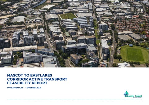
MASCOT TO EASTLAKES
CORRIDOR ACTIVE TRANSPORT
FEASIBILITY REPORT FOR EXHIBITION SEPTEMBER 2025
Bayside Council acknowledges the Bidjigal Clan, the traditional owners of the land on which we meet and work and acknowledges the Gadigal people of the Eora Nation. Bayside Council pays respects to Elders past and present.
1.0
1.1 PURPOSE
Bayside Council has undertaken a feasibility study to explore opportunities for a well -planned active transport corridor that meets the needs and values of the local community. Active transport corridors are high -quality, regional -standard routes designed for walking and cycling. Between Mascot and Eastlakes, there is an opportunity to upgrade the existing cycleway and enhance pedestrian facilities.
Objectives
This study aims to:
• Provide a comprehensive analysis of cycle route options between Mascot and Eastlakes, with the ultimate goal of delivering a high -quality, safe, and inclusive cycleway that accommodates users of all ages and abilities.
By addressing gaps in existing infrastructure and improving connectivity, the project seeks to position active transport as a viable, sustainable, and attractive choice for the community.
In addition to its transport objectives, this study supports Bayside Council’s vision for Mascot as a vibrant, liveable ‘Place for People’. The proposed cycleway upgrades are a key opportunity to improve safety, amenity, and identity, while strengthening active transport links within Bayside’s LGA and to major destinations such as the University of NSW and the Randwick Health and Education Precinct.
This work aligns with the Road User Space Allocation Policy, which encourages the strategic redistribution of road space to prioritise walking, cycling, and public transport where appropriate. It also applies the Movement and Place Framework, which recognises that streets like Coward Street serve both as important movement corridors and as places of local activity. These frameworks support the reimagining of Mascot to Eastlakes Corridor as a safer, more balanced environment that better reflects community needs.
1.2 CONTEXT
Coward Street, Gardeners Road and King Street are important east -west connections linking key residential, commercial, and industrial precincts in Mascot and Eastlakes. The east -west connection’s importance is heightened by its designation as a priority cycling route in state and local active transport strategies, such as the Sydney Gateway Active Transport Strategy, The Green Grid and NSW Eastern Harbour City Active Transport Plan.
Bayside Council has recognised the need for an eastwest route through this area as part of the Bayside Bike Plan 2024. This route will serve as a connection between Bayside LGA’s western suburbs to it’s eastern suburbs and beyond to major Sydney destinations such as Coogee Beach, UNSW, the Health Innovation Precinct.
As an outcome of the Sydney Gateway Active Transport Strategy, Transport for New South Wales (TfNSW) has delivered a new cycleway along the Alexandra Canal from Tempe Reserve to the Domestic Terminal, and is undertaking feasibility studies for the Alexandria Canal Active Transport Link.
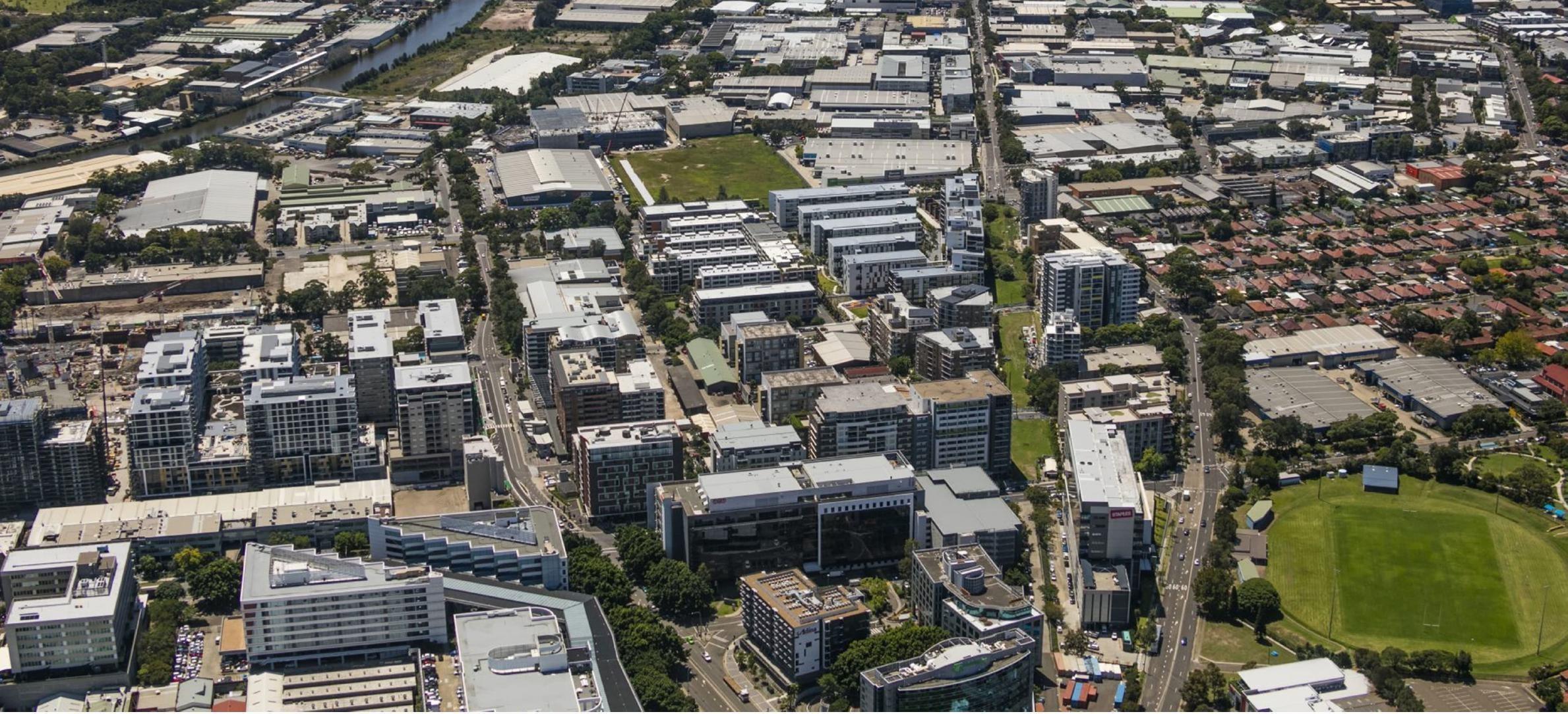
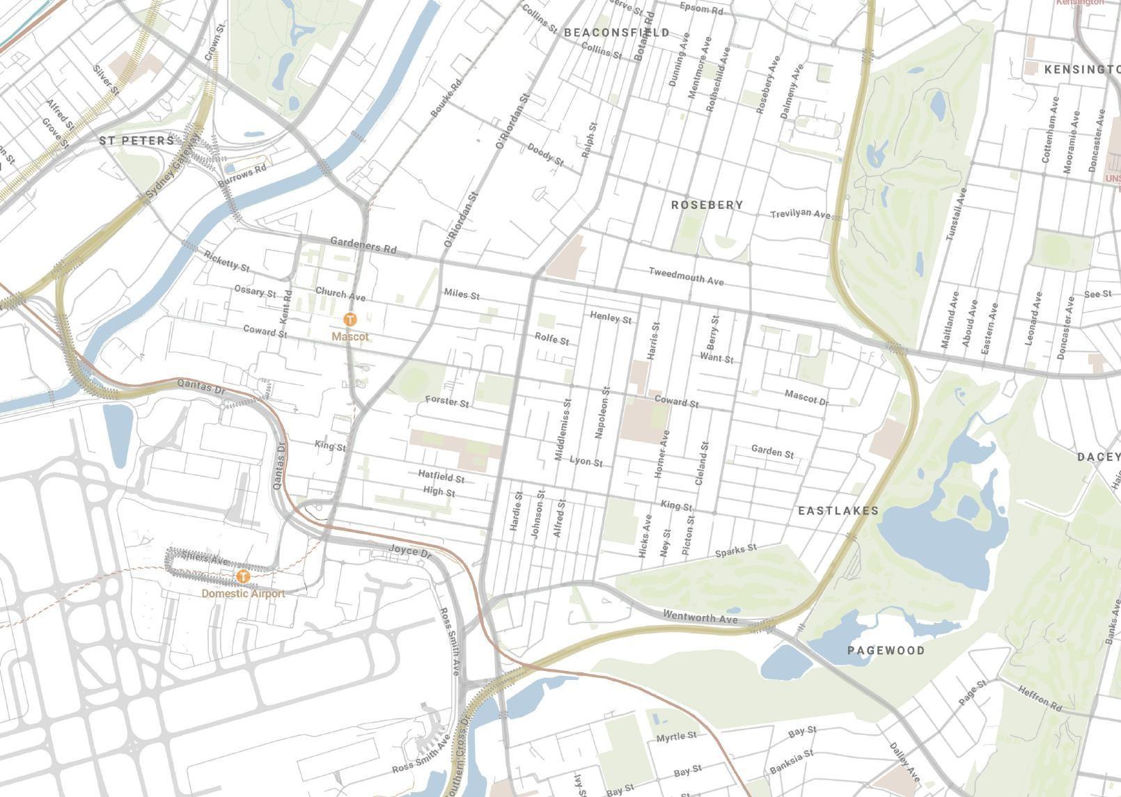
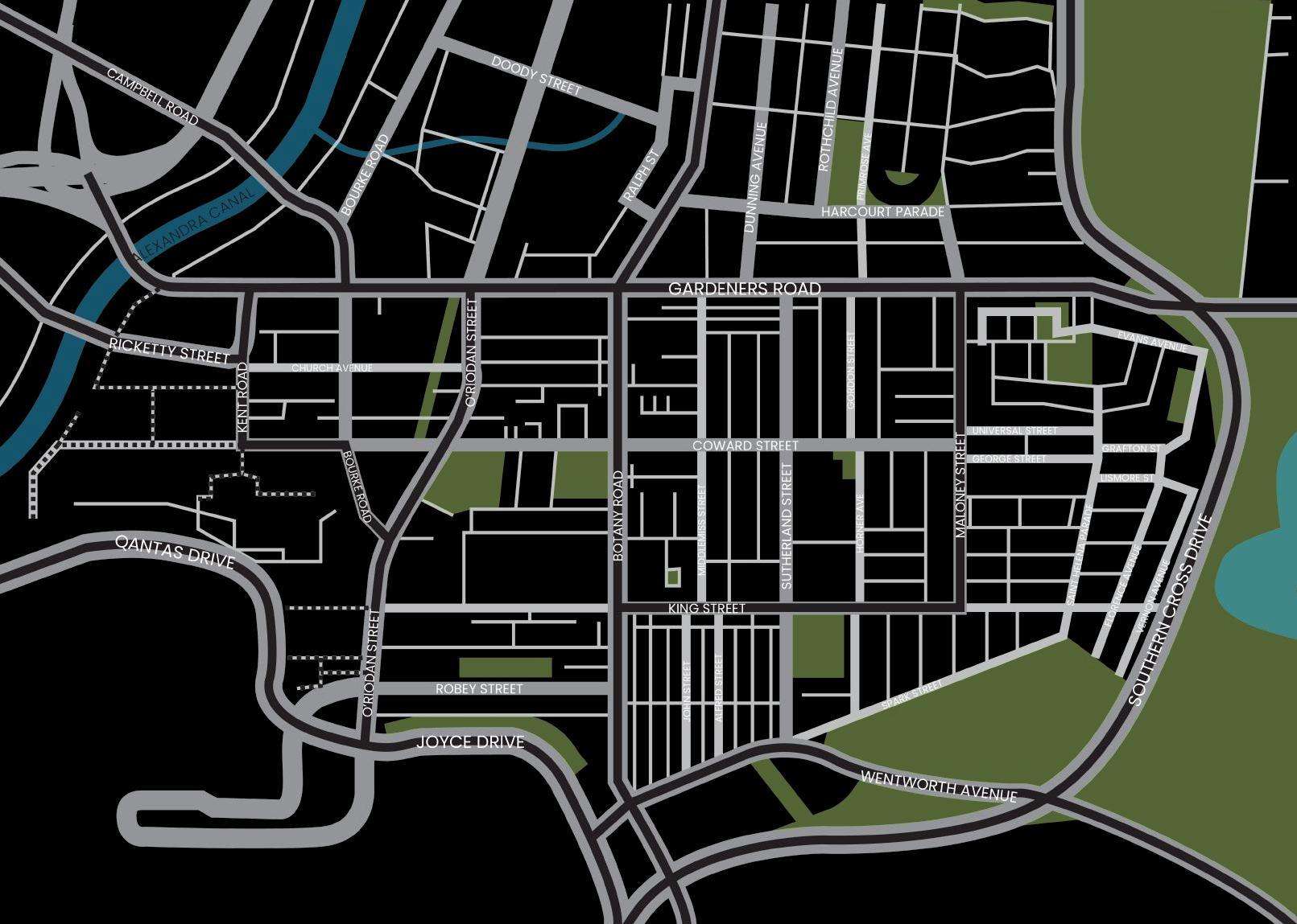
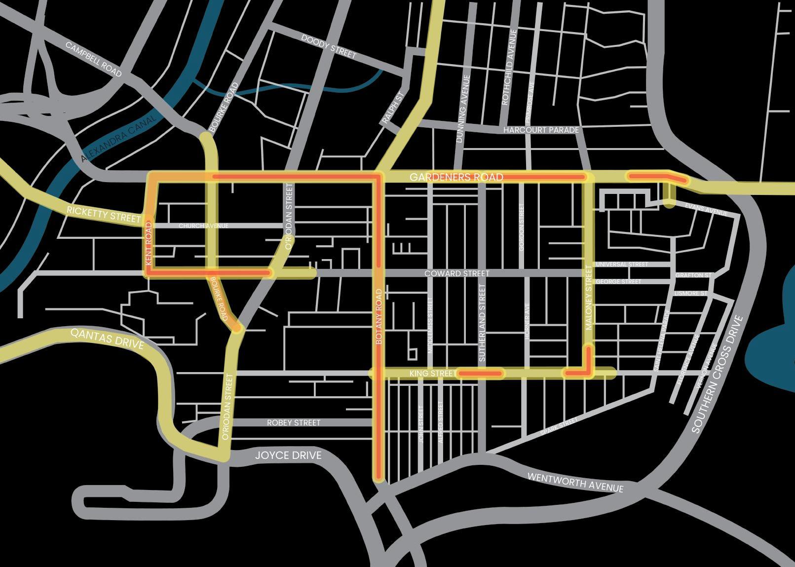
1.3 THE STUDY AREA
The study area centres on Coward Street, an existing disconnected east -west cycleway between Alexandra Canal and Eastlakes. TFNSW is conducting independent work for the area highlighted on the plan. More details are provided in section 1.4. The Bayside study area passes several schools, presenting an opportunity to improve access for students and encourage safer, more active travel to and from school. While Coward Street is a key focus, Bayside Council is also exploring alternative alignments and the broader precinct context to identify the most effective route. Any proposed solution must integrate seamlessly with the surrounding active transport network, meet local needs, and align with regional strategies.
As part of this feasibility study, investigations extend to include Gardeners Road and King Street, which run parallel to Coward Street. This comprehensive approach aims to establish a cohesive and integrated active transport network that supports connectivity across Mascot and its neighbouring precincts.
The existing infrastructure along Coward Street is inconsistent and aged, comprising a shared path between Alexandra Canal and Bourke Road, followed by an on -road route from O’Riordan Street to Maloney Street. A missing link exists between Bourke Road and O’Riordan Street. These limitations underscore the need for significant upgrades to ensure the safety, usability, and attractiveness of active transport in Mascot.
Bayside Council Study Area
LGA Boundary
TfNSW study area Town centres
Existing shared path
Existing on road
Desirable links
Domestic Airport
Mascot
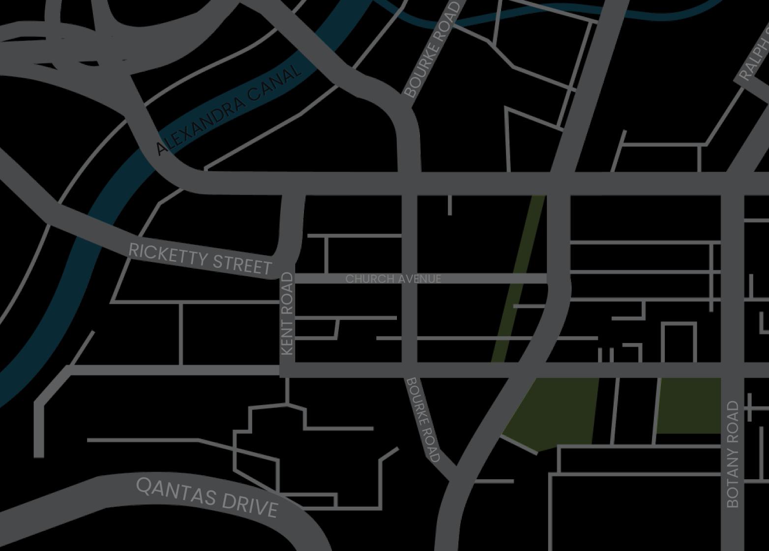
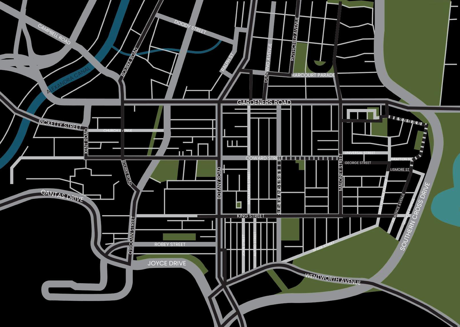
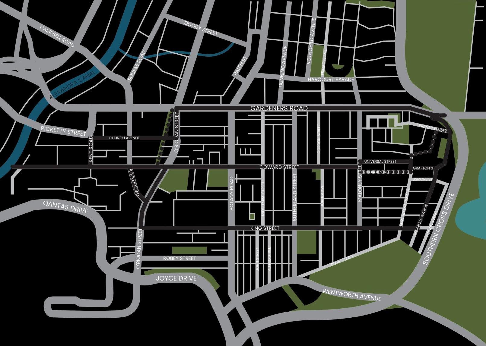
1.4 TFNSW SCOPE DEVELOPMENT
Transport for New South Waltes (TfNSW) is investigating active transport connections within a study area bounded by the Canal, Coward Street, Bourke Street and Campbell Road following on from previous work for a connection along the canal.
The study seeks to identify short and medium term opportunities to connect the Alexandra Canal shared path to local and regional destinations.
The investigation is being undertaken in consultation with Bayside Council and other key stakeholders.
FIgURE 1.2 TFNSW ROUTES UNDER INVESTIgATION
TfNSW routes under investigation
Shared Path
Separated Cycleway
BAYSIDESTUDYAREA
COWARD STREET
1.5 STRATEgIC ALIgNMENT
The project is informed and influenced by the strategic planning framework responding to both state and local government strategies and policies. Some of they key documents are listed below:
NSW GOVERNMENT STRATEGIES AND POLICIES
BAYSIDE STRATEGIES AND POLICIES
BAYSIDE 2030 - COMMUNITY STRATEGIC PLAN 2025 -2035, 2025 BAYSIDE LOCAL STRATEGIC PLANNING STATEMENT (LSPS), 2020 MASCOT STATION TOWN CENTRE PRECINCT MASTERPLAN, 2012
Additionally, the project is informed and influenced by the Bayside Transport Strategy and Bayside Bike Plan 2024. The Bayside Transport Strategy provides a number of actions which aim to enhance the existing transport network and plan for increased demand. The Bayside Bike Plan is a blueprint for achieving enhanced cycling network and a seamless network of bike routes across Bayside area. Some of the key principles are listed below:
1.7 CATERINg TO USER TYPES
The provision of a cycleway route between Mascot and Eastlakes must address the needs of the wide demographics which occur in this area.
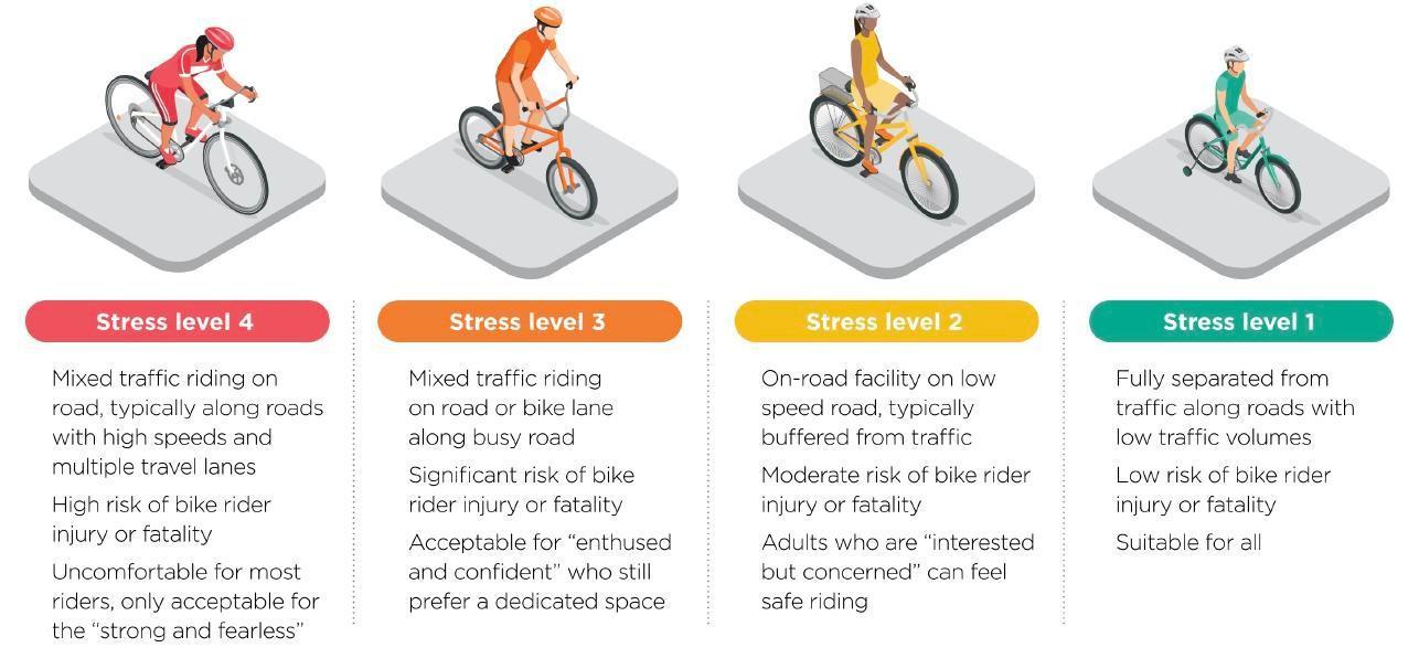
While a majority of residents are between 25 -34 years of age, there is also a notable growth in both 0 -17 and 60 and over (Figure 1.3). Additionally, given that 25% of households include children, Bayside must prioritise the delivery of safe cycleways which connect to local schools. As an outcome, the cycleway must aim to be suitable to all user groups and prioritise ‘Stress Level 1’ wherever possible, as indicated in Figure 1.4
Road usage and its ongoing evolution
Road users encompass a diverse range of transport modes, each with varying ability levels and infrastructure needs. Motor vehicles, including private cars and freight transport, dominate the road space and are often prioritised in urban planning. While cycling has steadily grown as an alternative mode of active transport, e -mobility users are a rapidly expanding transport segment, with usage increasing by 322% between 2020 and 2022. This growth offers greater accessibility and convenience for short -distance travel.
However, their safety is impacted by limited dedicated infrastructure, inconsistent regulations, and varying rider skill levels.
Pedestrians, including those with mobility impairments, rely on accessible pathways and safe crossings, yet often face risks from high vehicle speeds and poorly designed public spaces. E -mobility has broadened transport access for diverse ability levels, but concerns remain around shared path conflicts and road rule awareness. Balancing the needs of all road users requires integrated planning solutions which lower speed limits in high -pedestrian areas, and improved infrastructure for active and shared mobility.
Consistency in cycling infrastructure
Providing consistent design is critical in ensuring a seamless and predictable experience for all road users. Cyclists often transition between road -based and path -based infrastructure, requiring adaptability to different regulatory and behavioural expectations. On -road cycling aligns cyclists with vehicular traffic, necessitating adherence to road rules, speed expectations, and interaction with intersections. In contrast, shared paths impose different constraints, such as reduced speeds and negotiating space with other pedestrians. Shifting between cycling typologies can create challenges in maintaining safety, predictability, and compliance with infrastructure design intent. These shifts often create a facility which is slow, indirect, and unsafe. Where possible, Bayside is aiming for continuity in facility typologies, minimising abrupt transitions that require cyclists to frequently shift between road user and path user roles.
Emerging micromobility
While separate from demographics, Bayside Council also acknowledges the diversity of active transport
methods. For the purposes of this report, cycling can be expanded to include a wider range of micromobility, such as e -bikes, e -scooters, tricycles, cargo bikes and share bikes. Additionally, Bayside recognise the importance of overlaying pedestrian movement and the essential overlaps between cyclists and pedestrians needs.
FIgURE 1.3 DOUgHNUT DIAgRAM OF RESIDENTS AgE RANgE WITHIN THE MASCOT AND ROSEBERY AREA
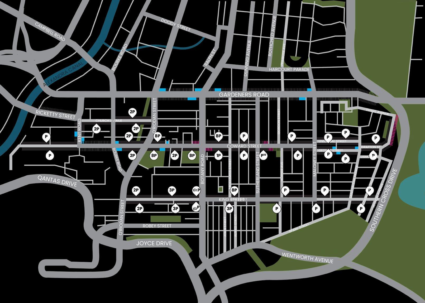
2. 1 PARKIN g
On street parking is measured by reviewing the enforced time limits and anticipated levels of turnover. Typically, the areas with restricted parking times and high turnover are associated with their adjacent land use; commercial areas, near schools, and close to key destinations such as the Sydney Airport. Lower turnover numbers are anticipated within residential areas.
Key Findings
The following findings can be summarised:
• High turnover park ing is concentrated between Kent Road and O’Riordan Street and near Botany Road, reflecting the commercial nature of these areas. It also occurs along King Street in proximity to the Airport.
• A number of clear zones exist in areas which correlate to known issues of traffic congestion:
- Gardeners Road is a key commuting corridor for both motorists and cyclists, particularly during peak hours.
- Kent Road and Coward Street west of O’Riordan Street is frequented by freight.
- Smaller pockets of clearway zones and no stopping along Coward Street align with local traffic congestion and local schools.
• Low turn over parking occurs to the east, aligning with the predominantly residential zoning.
Best Practice
When planning cycle routes, the relationship between parking turnover and cyclist safety must be carefully considered. Cyclists travelling adjacent to parked cars are more vulnerable to conflicts such as dooring, particularly in areas with high parking turnover.
Where turnover is low, simpler treatments may be adequate. However, in high turnover areas, it is essential to provide infrastructure that removes cyclists from the door zone and separates them from vehicle movements, either through physically separated cycleways or by relocating cyclists to alternative routes such as shared user paths.
Regardless of the facility type, design responses must reflect the local context, including parking patterns, pedestrian volumes, land use intensity, and anticipated cycling demand, to create a safe, comfortable and attractive environment for all users.
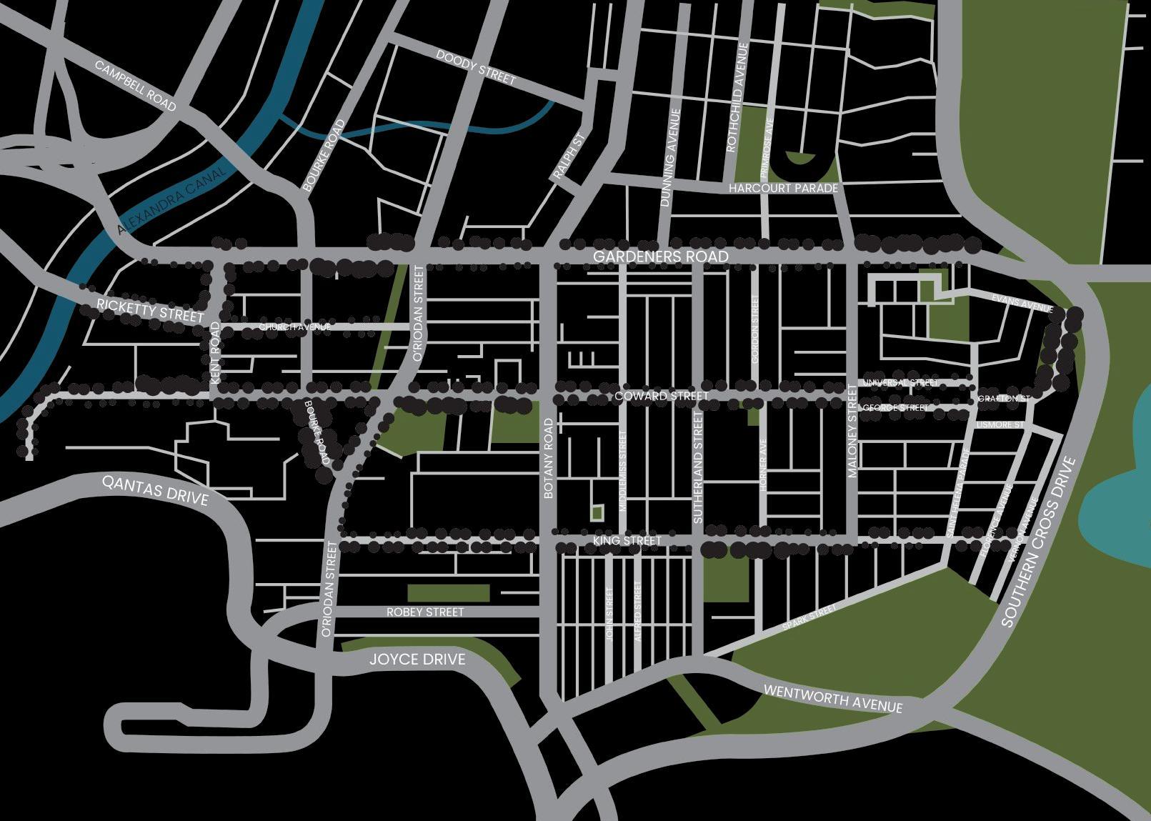
2.2 STREET TREES
The Mascot to Eastlakes area features a varying level of street trees. Tree density has been measured by comparing the quantity of trees along a given street per lineal metre. This does not necessarily reflect the existing canopy cover, as it includes both mature and juvenile trees. It does however, indicate how robust the future canopy cover is likely to be.
Key Findings
Overall, tree density varies across the site, with less street trees being found in the urbanised town centres and along busier roads.
Best Practice
The proposed cycleway route would follow a tree lined street to maximise the existing shade and amenity. A proposed cycleway route would seek to minimise impacts to street trees in order to maintain their role in regulating urban heat and carbon sequestration, attracting local wildlife.
2.3 FREIgHT ROUTES
Freight routes have been mapped based off TfNSW data and predominantly follows State roads. In addition, a number of local freight routes have been indicated to acknowledge the industrial zoning west of O’Riordan Street.
Key Findings
In its current state, the Mascot Town Centre Precinct is surrounded and intersected by freight movement. This is primarily occurring as freight moves to and from west to the Sydney Airport and Port Botany industrial precincts.
Frequent turns are required by freight as it skirts the perimeter of Mascot Town Centre, requiring wide turning circles, slip lanes and extensive road widths which are not conducive to cycle or pedestrian crossing.
A number of local roads are frequented by freight, most notably the industrial zoning between Alexandra Canal and the Mascot Town Centre Precinct. Cyclists and pedestrians are extremely vulnerable along freight routes as visibility is poor and trucks cannot easily stop to avoid vulnerable users. As a result, the proposed cycleway route must seek to resolve conflicts with freight in order to connect with the broader cycleway network.
Further to the east, freight is limited to Gardeners Road and King Street. Coward Street is only minimally impacted at the intersections of Botany and Maloney Street.
Freight routes are continuing to evolve as an outcome of the Sydney Gateway works, which aim to reduce freight and traffic congestion within the Mascot precinct and to align with the Movement and Place principles. TfNSW’s work regarding freight is in its preliminary stages and while beneficial, does not influence the decision making for this cycleway feasibility at this stage.
Best Practice
Cycle routes within freight corridors and industrial zones require careful planning to manage safety risks. Frequent freight turning at intersections, limited visibility, wide driveway crossovers, and the larger swept paths of freight vehicles all create potential conflict points with cyclists.
Where active transport corridors intersect with freight routes, high -quality design solutions are essential to ensure safe operations for all users. Physical separation of cyclists from the carriageway should be prioritised, without restricting freight needs such as turning radii, sight lines and driveway access.
There is an opportunity to review the current speed limits within the Mascot precinct and to improve road safety in high pedestrain areas.
2.4 BUS ROUTES
Bus routes have been mapped based on TfNSW data and attempts to cater to a wide residential and employment catchments including a range of residential densities, nearby industrial land and commercial zones.
Key Findings
A number of bus routes occur within the area, connecting with the Mascot Train Station interchange and caters to both the high density residential, commercial and industrial land uses.
A number of bus stops are located on narrow footpaths, creating bottlenecks in pedestrian flows. Some of these bus stops feature high patronage during peak hours greatly restricting pedestrian movement, and giving an indication of the reliance of public transport by the local community. This is particularly of note in the Mascot Town Centre Precinct where bus patronage is highest.
Further to the east, bus routes occur along Gardeners Road, King Street and George Street. JJ Cahill Memorial High School uses coach buses occasionally for sporting events, with a designated stop on Sutherland Street. Eastlakes Public School operates two buses on Friday mornings between 8:30 and 8:45am. Buses generally require wider travel lanes for manoeuvrability, however these roads experience relatively low bus frequency.
Best Practice
Cycle routes should aim to reduce overlays with bus routes. Large vehicle turning circles at intersections, frequent stopping and bus stop infrastructure all serve as potential conflict points with cyclists. Bus lane widths are typically wider than standard vehicle widths, reducing available carriageway space for high quality cycle infrastructure.
Where overlays between buses and cyclists are unavoidable, cycle infrastructure which places cyclists away from the carriageway, or provide robust physical barriers are essential to protect the users.
JJ Cahill Memorial
2.5 ACTIVE FRONTAgE
Active frontages have been mapped based on site visits to locate frontages which are vibrant and offer genuine activation with pedestrians and the streetscape users. In addition to this, we have considered where active frontages are anticipated to occur as an outcome of the DCP and future development applications requirements.
Key Findings
Mascot Town Centre is zoned as Mixed Use, and as a result is intended to include active frontages along all streets. In addition to this, a number of laneways are also activated. A majority of the quieter streets and laneways west of Bourke Road are well activated with restaurants and outdoor dining. By comparison, Gardeners Road, Kent Road and the streets east of Bourke Road are currently not activated, but may change in the future.
Botany Road and Gardeners Road are well established town centres with shop fronts facing busy trafficked road as well as the various roads which intersect it.
Smaller local centres occur at the corner of King Street with Sutherland and Maloney Street, as well as within the Eastlakes area.
Best Practice
It is important to respond to, and to protect active frontage where it occurs as it is plays a major role in creating a sense of place to a town centre and its community. It also plays an integral role is passive surveillence, social engagement and overall health to the neighbourhood.
Active frontages naturally attract high volumes of foot traffic, including pedestrians and shop patrons who linger, browse, or cross paths unpredictably. These conditions are not conducive to shared paths, where fast moving cyclists are more likely to come into conflict with slower and more variable pedestrian movements.
2.6 TRAFFIC COUNTS
PEDESTRIANS
Pedestrian counts were undertaken in November 2023, tracking movements at key intersections. The below is a summary of their findings.
The intersection of Kent Road and Coward Street experiences significantly higher pedestrian activity during weekdays compared to weekends. Pedestrian movement is notably greater in the east -west direction, likely due to the public transport to the east, and the many industrial businesses to the west.
The intersection of Bourke Street and Coward Street recorded the highest pedestrian traffic among all surveyed intersection, with a majority of volumes during weekdays. A majority of foot traffic crosses at the eastern side of Bourke Street, this is likely due to the position of Mascot Station and its connectivity to business to the south of Coward Street. It may also be influenced by road construction works which was ongoing during the pedestrian count period. On weekends, the southern side of this intersection has few pedestrians, likely illustrating the shops, cafes and other destinations occur only along the northern side of Coward Street.
The intersection of O’Riordan Street and Coward Street also shows greater pedestrian use on weekdays than on weekends. The highest usage is observed when crossing O’Riordan Street on the northern side of Coward Street, indicating a desire line between the lower density residential areas and Mascot Town Centre and the train station.
Further east, at the intersection of Sutherland Street and Coward Street follows a similar weekday –weekend pattern as O’Riordan Street but experiences lower overall pedestrian volumes.
On Church Avenue, pedestrian activity is higher on the western side of Bourke Street than the eastern side. Nonetheless, the eastern side sees significantly greater pedestrian movement in both directions during weekdays.
CYCLISTS
Cyclist counts were undertaken in conjunction with the pedestrian counts, tracking movements at key intersections. The below is a summary of their findings.
Generally, cyclists make up to 20% of all pedestrians within both the industrial area west of Kent Street, and east of Botany Road. Within the Mascot Town Centre area, this reduces to is little as 2%. Where cyclists occur along Coward Street, there appears to be a preference for the northern side.
The intersection of Kent Road and Coward Street experiences higher cyclist activity in the east -west direction, with slightly more occuring during the week as compared to the weekend. Despite this, it is clear that the area does have some weekend recreation appeal
The intersection of Bourke Street and Coward Street as well as O’Riordan Street and Coward Street exhibits a pattern similar to that of pedestrians. These numbers, however, are dwarfed by the pedestrian numbers.
Church Avenue follows a similar pattern to pedestrian traffic, with reduced quantities. Interestingly, Coward Street exhibited more cyclists despite Church Avenue’s existing separated cycleway infrastructure. This is likely a result of the limited connectivity to and from this route.
VEHICLES
Vehicle counts were undertaken using traditional traffic tubes along Coward Street at most intersections in November 2023. The below is a summary of their findings.
Industrial Area
The section of cul -de -sac section of Coward Street, west of Kent Road experiences higher traffic levels on weekdays as compared to weekends. On a typical weekday, traffic levels peak during rush hours, with more traffic heading eastbound in the evenings and westbound in the mornings. Overall, traffic activity in this section is quieter when compared to other areas of Coward Street.
Both eastbound and westbound directions maintain relatively consistent driving speeds throughout the day.
This section is primarily comprised of industrial businesses, which likely accounts for the traffic patterns observed in both the mornings and evenings.
Mascot Town Centre
The section of Coward Street between Kent Road and Bourke Street experiences higher traffic levels on weekdays than on weekends. On a typical weekday, traffic levels peak around 8 a.m. and 6 p.m.. Comparatively, traffic levels peak around midday on weekends. The eastbound direction experiences higher traffic levels during both morning and evening peak hours. The quantity of traffic slowly tapers off towards the end of the work week.
Between Kent Road and O’Riordan Street, the westbound direction exhibits higher traffic levels during evening peak hours. In contrast, between Kent Road and Bourke Street, the westbound direction experiences higher traffic levels during the morning peak.
Traffic speeds in this area typically fluctuate, often dropping 10-20km below the 50 km/h speed limit during the day, indicating traffic congestion. This alleviates in the evening. Traffic heading west between Kent and Bourke Street is less impacted by this fluctuation.
Near Botany Road
Both east and west of Botany Road exhibit similar traffic levels during weekdays. West of Botany, weekend traffic is typically lower than on weekdays. By comparison, east of Botany exhibits higher traffice levels during weekend than weekdays.
Near Sutherland
The section of Coward Street between Kent Road and Maloney Street (specifically near Sutherland Street) exhibits lower traffic levels in the eastbound direction compared to previous sections, with peak traffic occurring in the mornings. The westbound direction experiences peak traffic during both morning and evening hours. Additionally the westbound direction experiences higher traffic levels over the weekend than that of the eastbound direction, peaking around midday. Driving speeds in both directions fluctuate throughout the day, but generally remain below the 50 km/h speed limit.
Church Avenue
Church Avenue, west of Bourke Road, exhibits significantly lower traffic levels than elsewhere. Unlike Coward Street, Church Avenue exhibits a consistent traffic pattern throughout the week, with no significant differences between weekdays and weekends, and higher traffic levels during evening peak hours. Church Avenue, east of Bourke Road exhibits the lowest traffic levels of all previously mentioned locations. Like the other section, this one also shows no significant differences between weekdays and weekends, but lacks notable peak hours.
This indicates that Church Avenue is used primarily by local residents, and less so as a major thoroughfare or movement corridor.
Opportunties & Challenges
3. 1 OVERLAPPINg STREET USE
The adjacent plan provides an overlay and summary of the findings from:
• 2.3 Freight Routes,
• 2.4 Bus Routes, and
• 2.5 Active Frontage.
These three key street uses highlight the primary conflicts between pedestrians and traffic, with cyclists occupying a unique position of both pedestrians and traffic, yet fitting neatly into neither category. While these uses are explored individually in the previous chapter, their simultaneous occurrence creates limited street capacity for introducing additional uses, such as cycleways.
Key Insights:
1. Avoiding Conflicts
• Ideally, cycleways should avoid areas with complex or competing uses to reduce potential conflict. However, where these areas offer the most direct routes, careful design should be applied to minimise clashes while maintaining route quality and legibility.
2. Relocating Street Uses
• The next best approach would involve relocating one or more uses to free up capacity and to respond to TfNSW’s Movement and Place Framework. However:
- Freight and bus routes have a strong relationship to land use that is not easily changed by local government.
- Removing Active Frontage would compromise the vibrancy of town centres.
- Intersections require adequate space to accommodate vehicle queuing, ensure smooth traffic flow, and safely bypass turning traffic. The removal of travel lanes is not recommended in highly congested areas such as Mascot.
3. Car Parking Challenges
• In some locations, reallocating on -street parking may be explored to enable a safer and more direct cycle route without exacerbating road congestion. Any potential changes would be subject to site -specific assessment and community consultation to ensure a balanced outcome that reflects both access and safety priorities.
4. Tree Retention
• Removal of trees is undesirable. Their removal is inconsistent with other Bayside Council objectives to protect canopy and makes tree preservation a priority. The value of trees is significant in providing amenity, shade, ecology and street character. There are limited opportunities to remove low value trees in some locations.
3.2 CHALLENgE
The previous analysis pages summarise the key findings of desktop review, local knowledge and site visits.
This analysis is pivotal in identifying the potential advantages that can be strategically harnessed. By contrast, this analysis also identifies the challenges which must be addressed to ensure a successful future cycleway implementation.
The adjacent diagram and dot points summarise some of the key challenges which must be addressed in the development of cycle route options and their evaluation.
CHALLENgES
The permanent presence of industrial use results in freight activity, loading zones, and frequent turning which disrupts kerb continuity and increasing the potential for conflicts.
Multiple bus shelters along Coward Street - particularly between Bourke Road and O’Riordan Street - present high patronage use along the footpath, which is combined with frequent traffic congestion, resulting in limited space for potential cycle facilities.
Improvements to O’Riordan Street and Gardeners Road intersection require upgrades to provide quality cyclist and pedestrian safety while also catering to freight turning circles. Gardeners Road is the boundary of Bayside Council and City of Sydney Council. In addition, it is a state road under the jurisdiction of TfNSW Decisions made within this area will require detailed coordination to ensure there are no impacts on Bayside Council’s shop fronts.
Existing tree canopy creates pinch points and restricts opportunities for shared paths in some locations without canopy loss.
King Street is restricted by bus routes, freight and is less direct than other solutions.
George Street is currently part of the local bus route and has a mixed traffic cycle arrangement. Locating the cycle route on Universal Street avoids a majority of clashes with bus routes, bus stops and bus shelters.
3.3 OPPORTUNITIE
SThe previous analysis pages summarise the key findings of desktop review, local knowledge and site visits.
This analysis is pivotal in identifying the potential advantages that can be strategically harnessed. By contrast, this analysis also identifies the challenges which must be addressed to ensure a successful future cycleway implementation.
The adjacent diagram and dot points summarise some of the key opportunities which must be addressed in the development of cycle route options and their evaluation.
OPPORTUNITIES
Coward Street west of Kent Road features substantial tree canopy which provide shade and amenity for cyclists and pedestrians in an otherwise industrial setting.
Opportunity to connect to Alexandra Canal on the northern side of Ricketty Street, tying into future development in the area.
Bourke Road is defined by its significant fig tree canopy, which provide shade and amenity for pedestrians and cyclists.
Opportunity to improve traffic signals and provide connectivity between the proposed east -west cycleway and the existing north -south Bourke Road separated cycleway.
The existing separated cycleway along the western portion of Church Avenue and Linear Park provide a good flush to kerb precedent for its extension further east to separate cyclists from vehicles and pedestrians.
The absence of bus and freight routes along Coward Street east of Botany Road offers an opportunity for safe separated cycleways, but must be weighed against potential on -street parking loss (refer to challenge item 5)
Coward Street intersects JJ Cahill Memorial High School.
The available road width allows a separated cycleway with minimal impact on travel lanes or on -street parking.
Universal Street and George Street have appropriate road widths to allow for a separated cycleway with minimal impact to travel lanes or on street parking.
Florence Avenue intersects Eastlakes Public School. The available road width allows a separated cycleway with minimal impact on travel lanes or on -street parking.
Mascot Drive offers a slow vehicle speed environment and avoids the existing bus route / mixed cycle along Florence Avenue
Opportunity to connect to established cycle routes in City of Sydney, Randwick Council routes and eastern suburbs of Bayside Council.
Generally, there is also an opportunity to review road speeds in the vicinity of the proposed cycle route. The creation of a low -speed road environment ensures the safety of all street users and is conducive to creating high quality public street activation.
3.4 ROUTE OPTIONS ANALYSIS
Across the Mascot to Eastlakes corridor, three major routes have been explored.
Route A
This option prioritises a high -quality and direct cycle route, leveraging the existing separated cycleway along Church Avenue. It aims to minimise conflict points and deliver a consistent, safe standard for both cyclists and pedestrians. Route A is identified in the Central Green Grid as Project Opportunity 19.
While recommended, it is noted that:
• The section west of Bourke Road falls under a separate investigation by TfNSW; and
• The section along the northern side of Gardeners Road is consistent with the City of Sydney’s cycleway strategy.
Accordingly, this route is contingent on further collaboration between government stakeholders.
Route B
Route B is the preferred alignment for a continuous eastwest cycling connection between Mascot and Eastlakes. It intersects key local destinations -including schools, shops and community facilities -while maintaining a direct route with minimal turns, offering clear and intuitive wayfinding.
This alignment broadly aligns with the Sydney Gateway Active Transport Strategy, which supports the corridor up to Bourke Road. However this strategy only indicatively identifies its continuation further east.
Further investigation is required to determine the most suitable facility type -whether a separated cycleway or shared path -and to understand how these facilities may affect other competing street uses.
The following pages provide a comparative assessment of these design options along Route B.
Route C
Route C was initially explored as a lower -conflict alternative by avoiding streets with overlapping freight, bus, and active frontage uses. However, this approach results in a significantly less direct alignment that bypasses key destinations and reduces the route’s overall legibility and convenience for users.
Despite its intention to minimise conflict, Route C still intersects several high -conflict areas near Botany Road, Sutherland and Maloney Streets where bus, freight, and active frontage uses converge. This undermines the limited benefits gained from its otherwise lower -conflict sections.
For these reasons, Route C has not been progressed for further investigation as part of this study.
LGA Boundary
Broader active transport connections
Route A
Route B
Route C
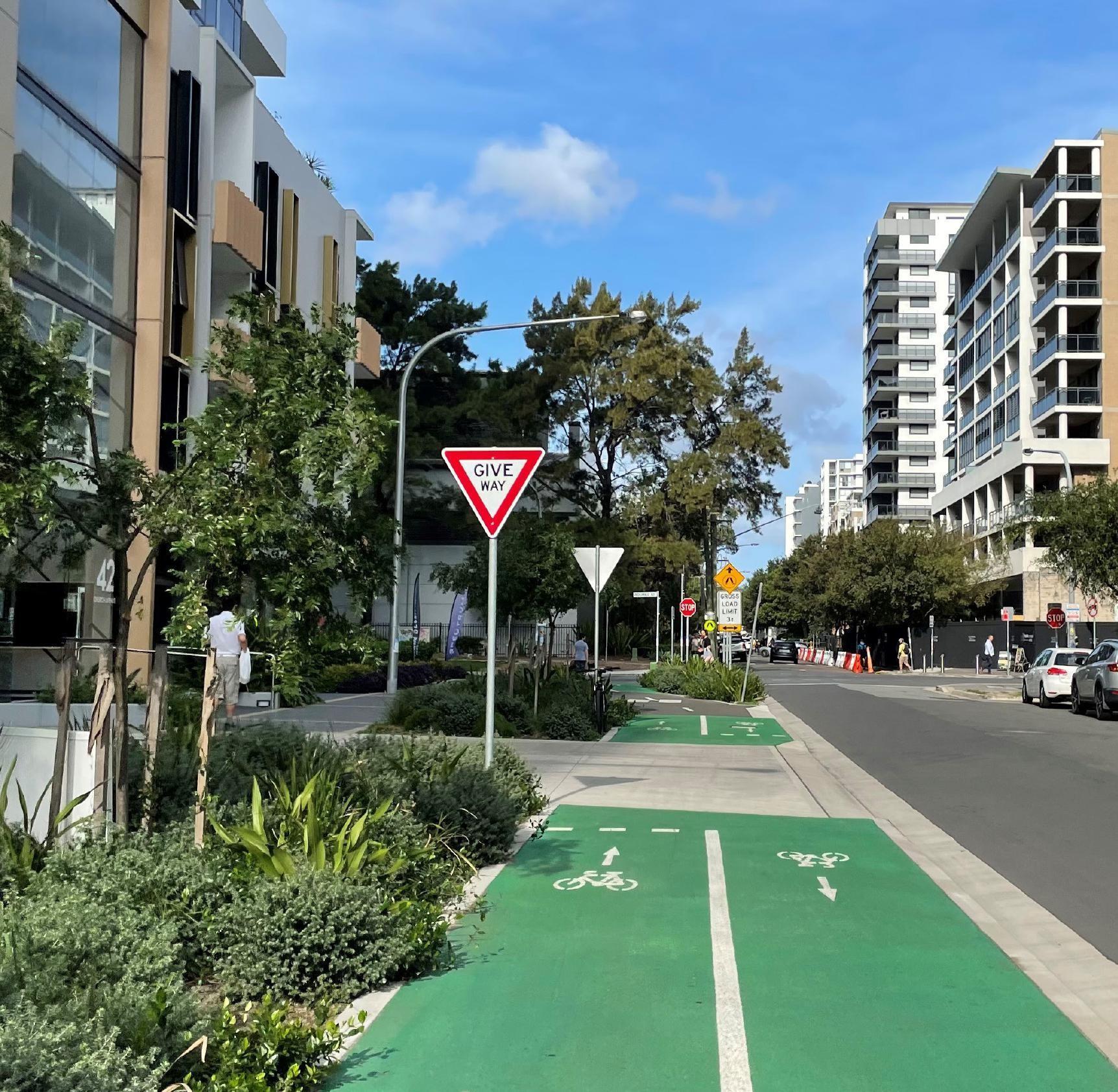
3.5 ROUTE B - SHARED PATH
A shared path arrangement is achievable along the full length of the Coward Street route.
While there are some minor complications due to bottleneck points, minimum widths of 2.5m are achievable and meet cycleway guidelines.
It is recommended that the shared path is located on the southern side of Coward Street as it ensures a smooth route alignment with clear sight lines. It features fewer driveway crossings and aligns with local parks and schools. To ensure a smooth route with fewer crossings, it is recommended that the shared path continues along the southern side of Universal Street, and the northern side of Grafton Street & Florence Avenue.
As a result, there are far fewer challenges in delivering a continuous shared path arrangement compared to a separated cycleway arrangement. However, the resulting outcome will provide a slower cycle speed than alternative solutions.
The provision of a shared path does not preclude on -road cycling. It is recommended that Coward Street be reduced to a 40 km/h speed zone and line -marked as a mixedtraffic cycleway. This approach supports experienced cyclists who prefer to ride on -road, while also providing a safer shared path alternative for a broader range of users, including children and less confident riders. Cyclists using the mixed -traffic arrangement must comply with standard road rules, including restrictions such as the existing “No Right Turn” at the intersection of Coward and Bourke Streets.
CHALLENgES
High pedestrian numbers and bus stop patronage creates a high chance for collisions to occur which cannot be adequately resolved. See figure 1.16 for detailed analysis.
Potential bottleneck at bus stop requires reduced cycle speeds.
Bottleneck at corner of Coward Street & Botany Road due to mature trees requires reduced width and cycle speeds.
Possible conflict with school during, pick -up and drop -off, requires reduced cycle speeds.
Possible conflict with existing fig trees and school during pick -up and drop -off requires reduced cycle speeds.
LGA Boundary
TfNSW scope
Shared Path Challenge
3.6 ROUTE B - SEPARATED CYCLEWAY
While a separated cycleway is achievable in few select locations, intermittent sections of Route B face challenges which must be mitigated. Council’s preference is to avoid small sections of shared path to address these challenges, acknowledging that frequent changes in facility type are known to be hazardous due to the change in speeds and infrequent interactions with slower moving pedestrians.
It is recommended that the separated cycleway is located on the southern side of Coward Street as it ensures a smooth route alignment with clear sight lines. It features fewer driveway crossings and aligns with local parks and schools. To ensure a smooth route with fewer crossings, it is recommended that the separated cycleway continues along the southern side of Universal Street, and the northern side of Grafton Street & Florence Avenue.
CHALLENgES
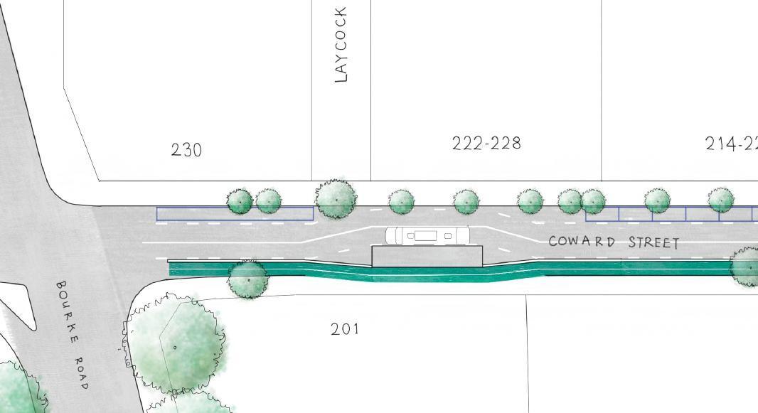
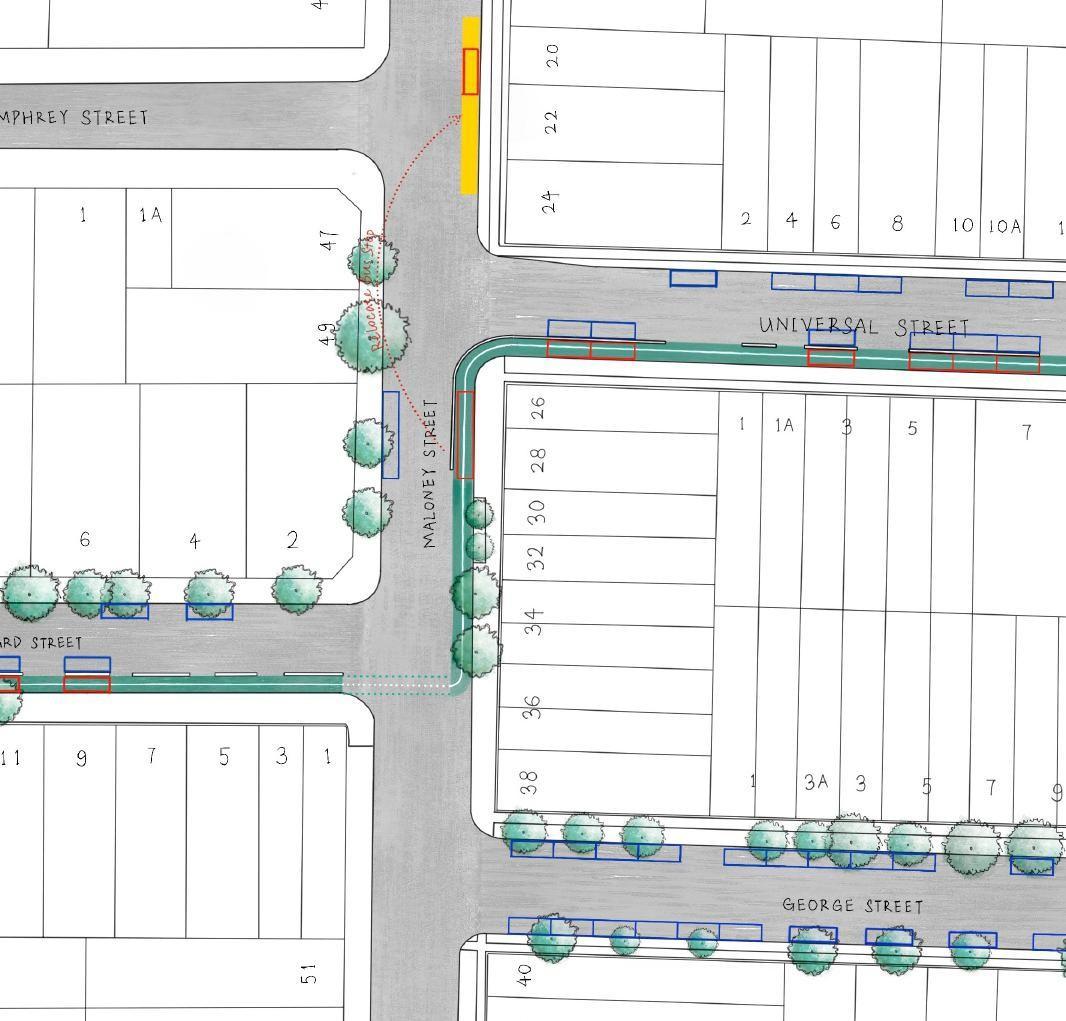
Due to bus stop, separated cyclists must enter the footpath intermittently between Bourke Rd and O’Riordan St. Alternative designs would impact multiple travel lanes / parking lanes. See figure 1.16for detailed analysis.
Separated at the corner of Coward St & O’Riordan St would require the removal of a dedicated turning lane with high usage.
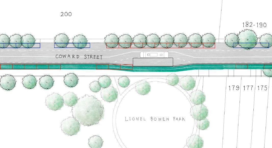
Due to bus stop, separated cyclists must enter the footpath intermittently near Lionel Bowen Park. Alternative designs would impact multiple travel lanes / parking lanes. See figure 1.17for detailed analysis.
Due to limited road widths, all southern on -street parking between O’Riordan St and Botany Road would be removed. Due to the limited road widths separated cyclists must also enter the footpath intermittently at road intersections.
Local pre -school “kiss & ride” must be relocated to Sutherland Street to ensure a safe drop off / pick up of school patrons
Due to bus stop, separated cyclists must enter the footpath intermittently if travelling north. Bus stop could be moved further north pending bus provider engagement.
Due to bus stop, separated cyclists must enter the footpath intermittently. Bus stop could be re -routed to Universal St pending bus provider engagement.
Insufficient road width along Evans Ave, Grafton Street, and Mascot Dr. To achieve separated cycleway on Grafton Street, the removal of both a travel lane and parking lane would be required. See figure 1.18-20 for separated cycleway and alternative arrangements.
Unsafe crossing at the intersection of Evans Ave and Florence Street will require detailed design to be resolved.
* Refer to next page for diagrams indicating schematic design
The configuration shown in Figure 1.16presents several design and operational challenges and is not supported as a preferred outcome for this section of Coward Street. Key issues include:
Westbound buses must stop in the travel lane, increasing traffic congestion.
This bus island is not appropriate as it does not fully comply with DDA requirements.
Conflicts between cyclists pedestrians and bus patrons at the island stop.
Loss of northern on -street parking.
Loss of southern on -street parking.
This option has been assessed as unsuitable due to its safety, accessibility, and traffic performance impacts.
Additionally, a shared path cycleway is likely to be unsuitable due to the high pedestrian numbers and active frontages within the area. A number of street trees, planter boxes and other obstacles create bottle necks which may lead to an unsafe environment. For this reason, Council recommends the cycleway avoid Coward Street between Bourke Road and O’Riordan Street.
The configuration shown in Figure 1.17presents several design and operational challenges and is not supported as a preferred outcome for this section of Coward Street. Key issues include:
Removal of the dedicated left-turn lane at O’Riordan Street, reducing intersection efficiency.
Loss of southern on -street parking.
Loss of northern on -street parking.
Westbound buses must stop in the travel lane, increasing traffic congestion.
This bus island is not appropriate as it does not fully comply with DDA requirements.
Conflicts between cyclists pedestrians and bus patrons at the island stop.
This option has been assessed as unsuitable due to its safety, accessibility, and traffic performance impacts. By comparison, a shared path solution resolves these traffic impacts, requiring cyclists to move at slower speeds appropriate for the site. Council believes this is an appropriate solution, given the wide verges, lower density residential setting and the lack of active frontages and shops in the area.
3.8 SEPARATED CYCLEWAY CHALLENgES
To achieve a separated cycleway along Coward Street, southern on -street parking must be adjusted. This is also the case for George Street, with on -street parking adjustments along the northern side. While this will narrow the available road width, this will have no negative impact on its current usage.
This option is not preferred, due to its impacts on multiple bus stops and required changes to well established bus routes.
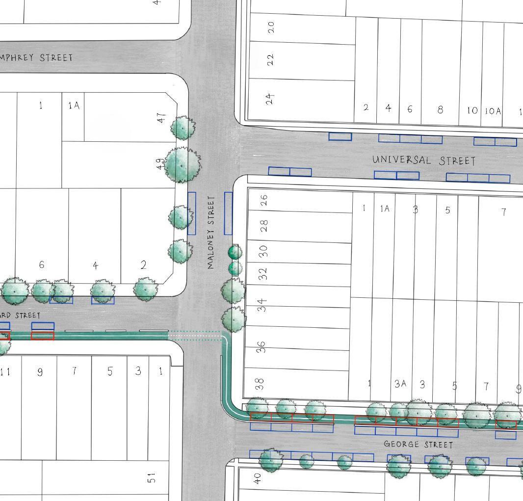
As an alternative solution, the cycleway could use Universal Street instead of George Street. This solution requires a similar adjustment to on -street parking, with no negative impact on the current road usage.
This is the preferred solution as it allows for a streamlined cycleway arrangement at the intersection of Maloney Street. This has the additional benefit of connecting with shop fronts. While the relocation of a single existing bus stop is required, it does not impact the established bus routes.
3.9 SEPARATED CYCLEWAY CHALLENgES
To achieve a separated cycleway along George Street, northern on -street parking must be adjusted. While this results in no quantum change, the east -bound bus stop must be relocated to Universal Street to avoid conflicts between cyclists and bus patrons.
To achieve a separated cycleway along Grafton Street, the road must be reduced to a yield street, or one -way, including the removal of the northern on -street parking. This has been recommended as an appropriate solution as this will assist in reducing through -traffic, slowing speeds in a residential area and has potential for further amenity improvements.
FIgURE 1.20 INDICATIVE SEPARATED CYCLEWAY DESIgN ALONg gEORgE STREET & gRAFTON STREET (PREFERRED OPTION)
RECOMMENDED ROUTE
The following recommendations are made:
• Route B treated as the proposed local route, implemented predominantly as a raised separated cycleway. A portion of shared path along O’Riordan Street and Coward Street up to Botany Road is required due to available verge space and weighing the impacts a separated cycleway would have on travel lanes and congestion.
A direct comparison of Route B and C indicate that the number of advantages offered by Route B, and Route C’s reliance on major traffic intervention, resulting in Route B being better.
The below lists some of the key actions required to deliver Route B:
Tie into cycleway proposal under development by TfNSW.
Upgrade traffic signals to facilitate improved northsouth cyclist access along Bourke Rd (by TfNSW ).
Explore opportunities to improve traffic signals and raised threshold crossings at privately used driveways as a future project ( by TfNSW ).
Upgrade traffic signals to facilitate improved pedestrian / cyclist crossing directly from Bourke Rd south to the eastern side of O’Riordan St (by TfNSW ).
Investigate feasibility of shared path along O’Riordan Street’s western verge south of Bourke Road intersection as a future project (by TfNSW ).
Upgrade all signalised intersections along Coward Street to facilitate improved pedestrian / cyclist crossing times.
Review existing round about to accommodate best practice separated cycleway infrastructure.
Seek relocation of ‘Kiss & Ride’ to Sutherland Street to remove conflicts with separated cycleway design.
Upgrade signalised intersection at Maloney Street.
Relocate existing bus stop on Maloney Street to sit further north.
Consider removal of travel lane and northern on -street parking in Grafton Street to allow an uninhibited separated cycleway design.
Provide upgrades to improve pedestrian and cyclist safety entering Florence Avenue Reserve from Florence Avenue.
Explore future opportunities to connect further east via existing connections to Gardeners Road.
In addition, a review of vehicle speeds in the vicinity of the cycle route should be undertaken with the intent of creating a slower speed, safe environment which acknowledges both the existing schools, town centres as well as the proposed active transport infrastructure improvements.
4.2 NEXT STEPS
ENGAGEMENT
Bayside Council has actively engaged key stakeholders during the feasibility study, including:
• Transport for NSW (TfNSW) - via regular meetings and workshops to coordinate project scope and ensure alignment with nearby state led cycleway projects.
• City of Sydney Council, public transport operators, and local schools - to identify existing constraints and explore integration opportunities.
This early collaboration ensures a consistent approach across jurisdictional boundaries and lays the groundwork for joint delivery where applicable.
Bayside Council will now progress to community engagement to share the findings of the feasibility study to gain feedback and further refinement from residents, local businesses, and cycling groups. This process is essential in order to identify any specific concerns or local issues and ensure design responses are informed by lived experience, and to garner awareness for the project’s broader safety and connectivity improvements.
A post exhibition report will be prepared, presented to Council and made available to the community.
IMPLEMENTATION
As part of the feasibility study, it is anticipated that the total project cost will range between $4.5 and $6.5 million. This cost is indicative only, and will be further refined as a part of the concept and detailed design process.
Council will seek grants from a number of sources where and when they are made available for the delivery of this project. Examples include the TfNSW Get NSW Active program and road safety grants, as well as infrastructure contributions and other State and Federal road safety programs.