30
CHESTER BORROWS
MP for Whanganui
Best wishes to all those affected by the recent floods
Authorised by Chester Borrows MP 94 Victoria Ave, Wanganui Phone (06) 348 9150 chester.wanganui@parliament.govt.nz
Specialising in Property & Financial Management 176 Glasgow Street PO Box 4003 Wanganui 4541 Ph: 06-349 0903 Fax: 06-345 0713 www.educationservices.co.nz
JAMIE O’LEARY BUILDERS LTD
WANGANUI FLOOD JUNE 2015
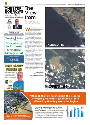
The View from Space W
hile the floods that swamped Whanganui last weekend appeared devastating enough from pictures taken from helicopters, the view from space has offered another perspective altogether. The NASA and USGS operated Landsat 8 satellite, which orbits Earth once every 98 minutes and repeats the same ground track every 16 days, snapped this image of floodwaters pouring out of Whanganui River and into the sea as it passed over New Zealand on Saturday. A “before” image shows what the landscape looks like in summer. Dr Murray Ford, a geomorphologist at Auckland University, checked the satellite’s latest images and spotted how it had captured the “massive discharge” of sediment from land. The flooding - the worst on record Whanganui’s - forced the evacuation of hundreds of homes and left dozens of people stranded. Damage assessments were this week still being carried out across the Manawatu and Taranaki regions as the clean-up continued.
New Home Building Renovation Work Light Commercial
Jamie Morton Science Reporter The New Zealand Herald
Office: 06 343 5007 Mobile: 0274 926 995 Email: jamieo@xtra.co.nz BUILDING FOR 38 YEARS
although the rain has stopped, the clean-up is ongoing. Our hearts go out to all those affected by flooding across the Region. 15.7 m
2004
11.1 m
2015
8.2 m 6.3 m
RiveR peak heights 2004 vs 2015
Rangitikei at Mangaweka
13.2 m
Turakina at O’Neill’s Bridge
7.8 m
Whangaehu at Kauangaroa
9.0 m
Whanganui at Town Bridge
13.3 m 11.7 m
10.2 m
2004 2015 Whanganui at Pipiriki
Visit www.horizons.govt.nz or contact us on toll free 0508 800 800
the widespread flooding of June 2015 was the largest event of its kind in the horizons Region since 2004. The Whanganui River reached its highest peak on record and flowed at a rate of 4,690 cubic metres per second. The recovery will be lengthy but we will be working alongside our communities in the weeks and months to come.