AMY CHOY LANDSCAPE +URBANISM DESIGN PORTFOLIO 2019


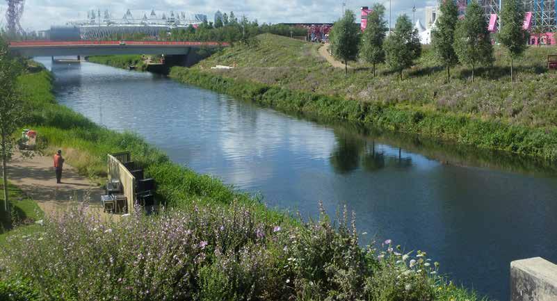
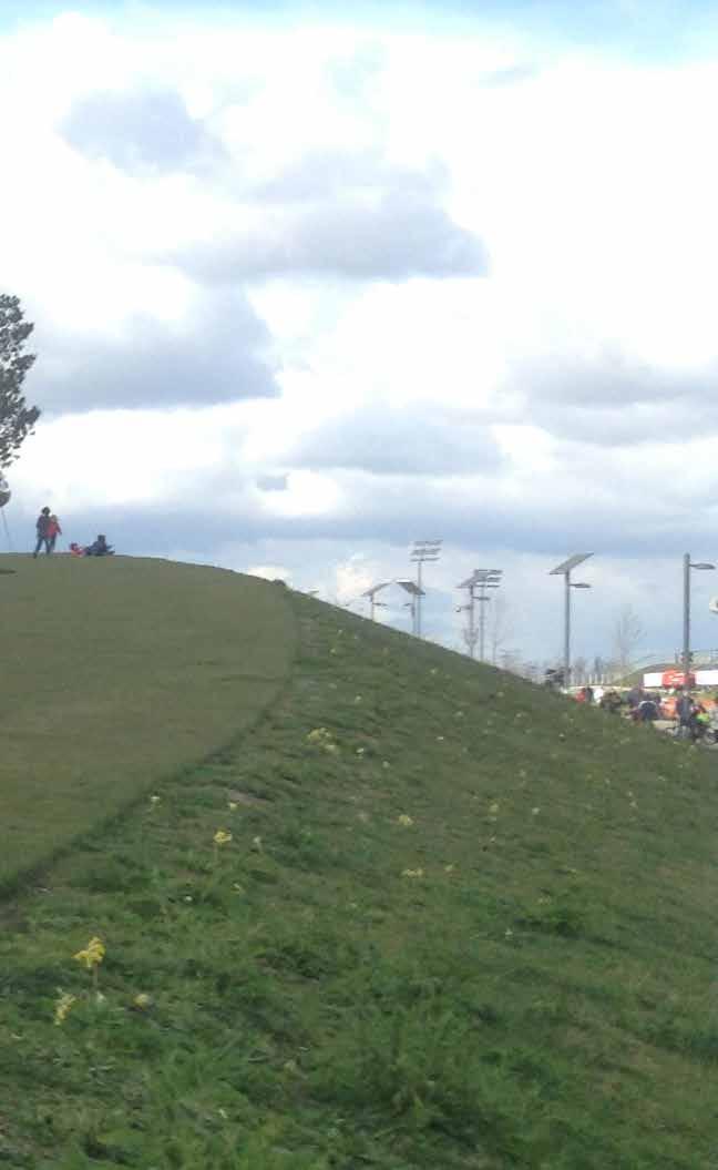
[London Olympics
2012] Image Credit : My Visit in London 2014
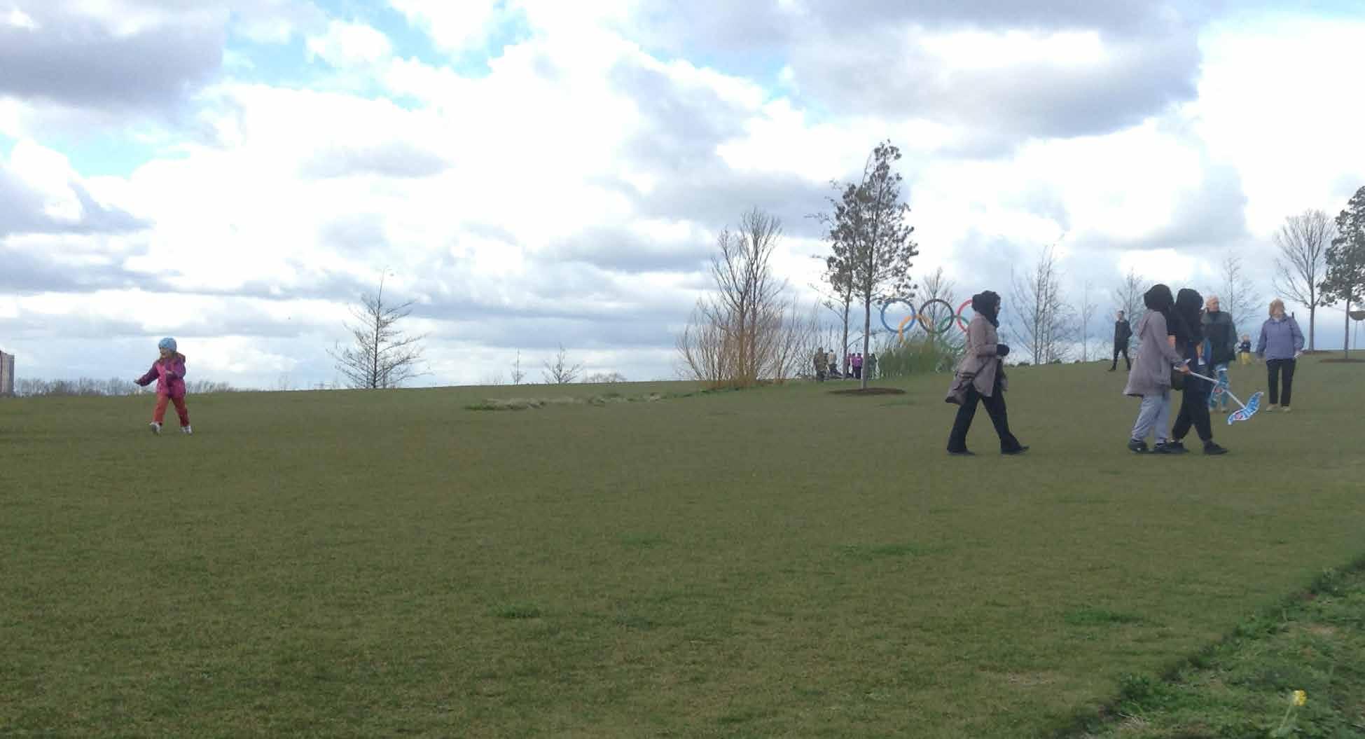
LANDFORM Elizabeth Park Parkland
. Queen
I like to do see myself as a playful large-scale sculptor most of the time.
WHY DID I PICK LANDSCAPE ARCHITECTURE?
3
In many ways I think landscape architecture picked me. Back in 2003 I went to UPENN for the master’s degree in architecture. I was going to become an architect. A few months into my grad school study, my professor told me I should go see James Corner and his landscape departments work. He said that my broad and systematic thinking would fit better as a landscape architect with James’s landscape teaching. That is how I went and got my dual degree.
I kept selected architecture in jobs until 2008 while in London I needed a job and I walked into Hargreaves where they just landed on their legacy project and their only staff quit during holidays.
I’ve enjoyed large scale landscape works since.
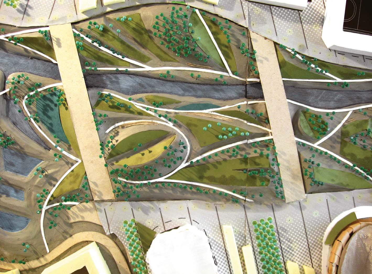
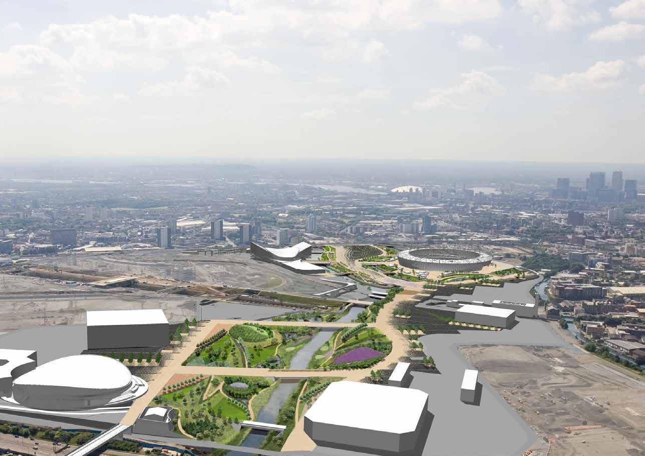
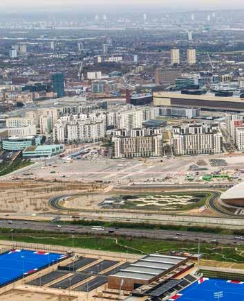
CLAY MODEL Queen Elizabeth Park [London Olympics Parkland 2012] Image Credit : Hargreaves Associates
“ THE ART OF SCULPTING THE GROUND TO CREATE, TO CONNECT AND TRANSFORM OUR URBAN FABRIC TO A ONE THAT ENHANCES ITS SOCIAL, ECONOMICAL AND ECOLOGICAL ENVIRONMENTS”
WHAT IS LANDSCAPE ARCHITECTURE TO ME?
5
6 ADHESIVE SAND MODEL . Athletes Village Chobham Place [London Olympics Parkland 2012] Image Credit : VOGT Landscape Ltd.
CONNECTIVITY + MOVEMENT
(or as OLIN called it place making or as some earth artist may say spatial organization, choreography)
WHAT IS LANDSCAPE ARCHITECTURE TO ME?
7
SCULPTING SPACE
IDENTITY . NARRATIVE . A STORY
Any outdoor spaces must be able to withstand its use over time, as well as any factors from nature. My landscape design utilizes these factors as opportunities in the design process and uti lizes landscape elements to create a sustainable landscape, one that would endure human activities uses, protects and minimizes environmental impact, and maximize/encourage biodiversity wherever possible.
INTENT + VALUES
PERMEABILITY + CONNECTIVITY OF CITY, PEOPLE, AND NATURE
9
RESILIENT + SUSTAINABLE DESIGN
In our fast pace stressful modern world and economy, it is important for the people to have public space to encourage outdoor activities and create a healthier lifestyle. This particularly applies to city of high population + density such as Hong Kong and cities of China. My landscape design intends to engage people and encourage them to go outdoor through provisions of variety of public spaces, from active to passive
Connectivity in any urban fabric has large influence on the quality and the social value of public space. Vast and open connected circulations + spaces often lead to heathier social spaces as they are accessible which leads to higher degree of social interactions.
3 CORE VALUES that I intend to achieve in my landscape designs: HEALTHY + OUTDOOR LIFESTYLE
Connectivity of people to the nature is also an important aspect in outdoor public realm designs as it creates a more natural environment for people.My landscape design intends to maximize both types of connectivity to create a socially and spatially connective environment for a healthy lifestyle
- with
-
Forms from Nature and Mainly the understanding of randomness of people movement (the tables and chairs drawing)
GENERAL TO SPECIFIC FORMS + LANGUAGE
Design
-
Site Generated, Contextual -MOBILITYMobillity of the form to various typologies and site contexts - Adaptive to different programmes - Morphology of form
Nature
DESIGN APPROACH
11
YANGCHENG LAKE LANDSCAPE MASTERPLAN, SUZHOU, >200haCHINA
>100 ha | Concept and Schematc Design, Visualizaton, Planning Applicaton, Detail Design | Olympic Delivery Authority
PRACTICE LOCATIONS
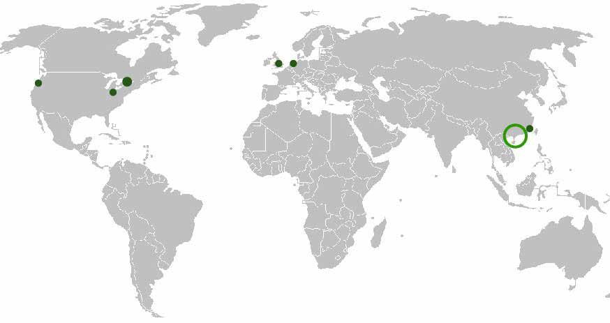
GLOBAL EXPERIENCE
>100HA | Envision to DD | Xidian Development Coroporaton
Member of LI (UK), enroute to Chartership
LANDSCAPEPROFILE
DESIGNER + URBANIST
LIUCHUAN PHASE 1 + 2 RIVER REVITALISATION, TAI CHUNG, 15haTAIPEI**
KWU TONG, FANLING NDA DESIGN GUIDELINES + FRAMEWORK, HONG KONG
LARGE SCALE PUBLIC REALMS >10 ha
San FranciscoTorontoPhiladelphia LondonAmsterdam HongShanghaiKong
Amy is an internatonal landscape designer with mult-disciplinary background and training. She has a versatle portolio of design across a broad range of project typologies from large scale public realm, to mixed use commerical development, high end residental projects as well as city scale urban design.
AMY WAI YAN CHOY

12 TYPOLOGY | PROJECT TITLE
PROFESSIONAL PRACTICE EXPERIENCE
15km long | Envision to DD | Huang He Design Insttute
| Envision to SD, Design Guidelines | Suzhou Industri al Park
MLA’08, M’ARCH’08, BA(HONS)’’03
CITIC NEW TOWN MASTERPLAN, XIDIAN NINGBO, CHINA
Citzen of Hong Kong and Canada
JIALU RIVER PARK DESIGN, ZHENGZHOU, HENAN, CHINA
GAOYAO CANALSIDE LANDSCAPE, WATERFRONT + BRIDGE DESIGN, CHINA
<200ha |Masterplanning to Schematc Design | Gaoyao Development Corporaton
She emphasizes on developing dynamic concept design with innovatve and sustainable ideas, and carring them out from inital stages of design through to executon.
| Envision to Constructon, Tai Chung Authority
>500HA | Envision to Design Gudielines |CEDD
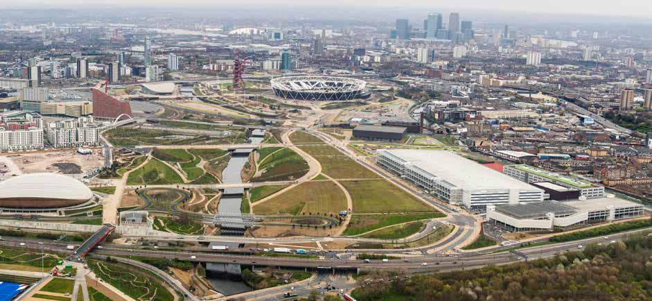
QUEEN ELIZABETH OLYMPIC PARK, 2012 GARDENS + ATHELETES VILLAGE**
TENDER SUBMISSION
SHATIN36CRESIDENTIALSEMI
MASTERPLANNING/FRAMEWORK + URBAN DESIGN
2 ha | Envisioning to hard landscape detail design
13TYPOLOGY | PROJECT TITLE SMALL SCALE PUBLIC REALMS <10 ha SHEKOU OCEAN WOLRD RIVERINE GARDENS, SHENZHEN 2.5CHINAha | Envision to SD | China Merchant Bank KAI TAK RIVER IDEAS DESIGN COMPETITION ** >2.5ha | Envision | CEDD TATE MODERN PHASE 2 LANDSCAPE, SOUTH BANK LONDON, 2.5UK ha | Detail Design | TATE Modern MIXED-USED COMMERCIAL RAYCOM Podium Mixed Used Landscape Development 40 ha | Schematc Design, Design Development | Raycom Development Corp. TONGZHOU MIXED USED LANDSCAPE MASTERPLAN, TONGZHOU, CHINA 35 ha | SD to CDR | Fuwah Development Corporaton HANGZHENG PLAZA COMMERCIAL DEVELOPMENT, GUANGZHOU CHINA 11 ha | Design Development | Sun Hung Kai Propertes Rehen Spring Mixed Use Development ,Chengdu, China 2 ha | Concept and Schematc Design | Shui On Land Limited RESORT + HOSPITALITY W HOTEL NORTH BUND, LANDSCAPE DEVELOPMENT, SHANGHAI, CHINA 0.25 ha | Schematc to Design Development | W Hotel Chain . Sina Mars App COTAI CASINO GARDENS, MACAU** 0.5 HA | Design, Schematc Design | Cotai Hotel Chain
35 ha | Concept+ Schematc Design , AIA award submission and exhibiton
PRIVATE FLATS HOUSING LANDSCAPE, SHEK MUN, HONG KONG
0.2SCAPEha
2 ha | Envisioning to schematc design | Henderson Land Development
XIAMEN LUQING LAKE QUARRY TOWN MASTERPLAN, XIAMEN, 755haCHINA
0.5 ha | Tender Submission | Housing Authority
SAI KUNG CLEAR WATER BAY PRIVATE DEVELOPMENT LAND-
80 ha | Envision, Concept Design, Schematc Urban Frame work | Envision YUNTAI TIANJIE STONE WATER RESORT DEVELOPMENT - 3 SITES, ZHENGZHOU
99ha| 40 ha | 9ha | Envision, Concept + Schematc Urban Framework Design
BANGALORE STONE PALM VILLAGE - SUBURB RESIDENTIAL DEVELOPMENT, INDIA
TUEN MUN PRIVATE RESIDENTIAL TOWER AND VILLAS
SAU MAU PING AFFORDABLE HOUSING REDEVELOPMENT
| Envision, Concept Design, Schematc Urban Framework
ENVISION SUSTAINABLE CAMPUS, LANDSCAPE MASTERPLAN, NANJING CHINA
| Envisioning to hard landscape detail design | ChinaChem
15
QUEEN ELIZABETH PARK
XIDIAN NEW TOWN
CANALSIDE LANDSCAPE MASTERPLAN
KWU TUNG NEW TOWN
“A TOWN PLAZA OF UNIQUE CONTEXT IDENTITY AND A DYNAMIC LIVING TOWN”
HEIFEI RIVER RESTORATION
“SUSTAINABLE WATERFRONT AND ECO-FOREST CITY”05 06 07
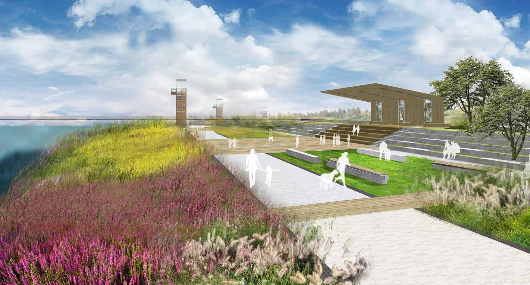
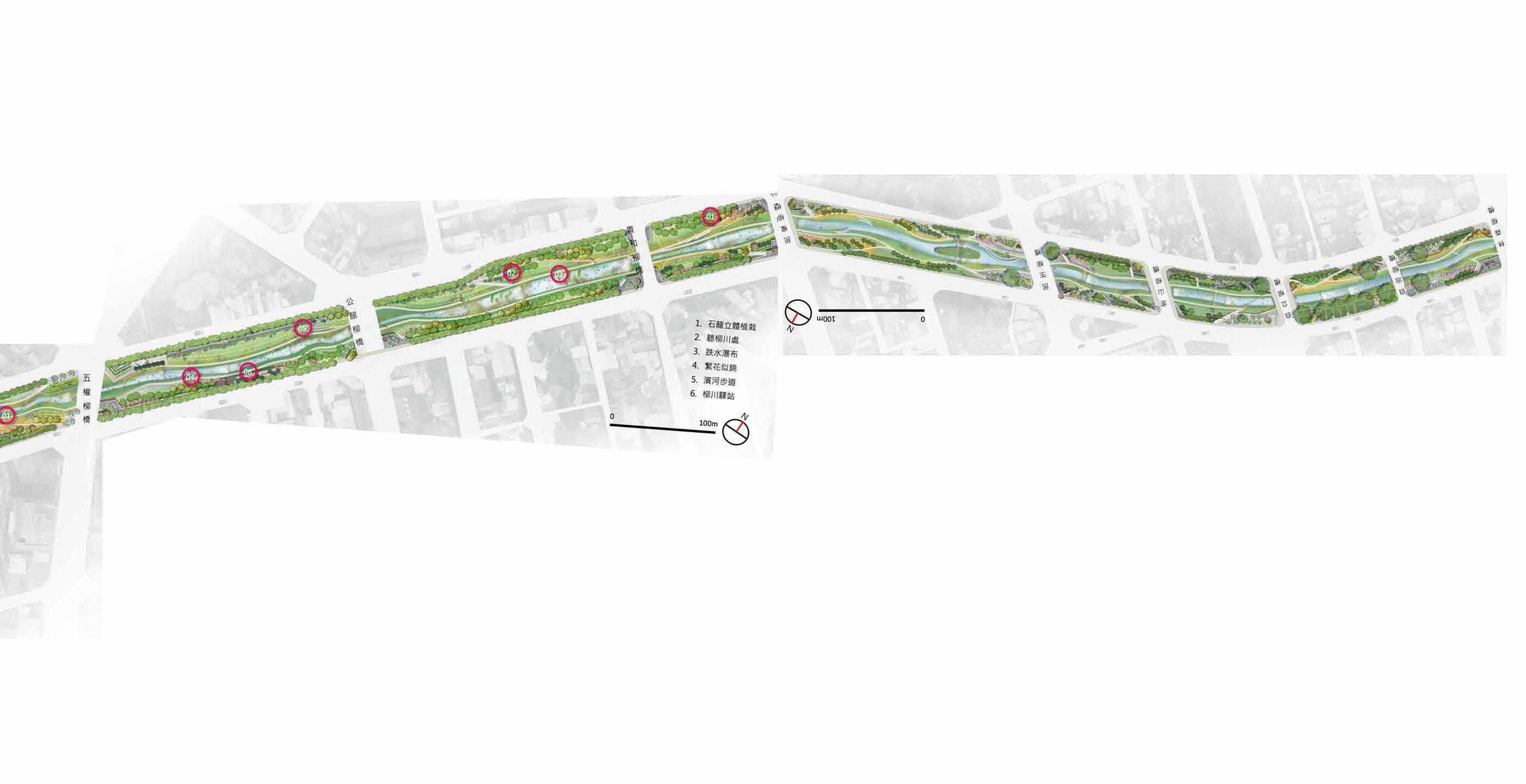
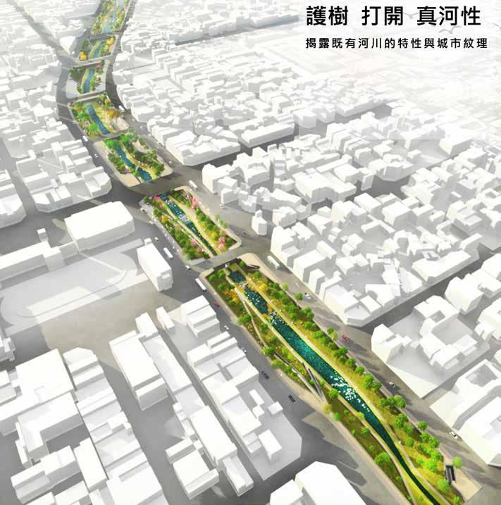
LIUCHUAN RIVER REVITILISATION
“RE-EMERGENCE OF NATURAL RIVER COURSE”02
“SUSTAINABLE WATERFRONT AND ECO-FOREST CITY”
“TRANSFORMING INDUSTRIAL SHIPYARD TO A POST-INDUSTRIAL LANDSCAPE”04
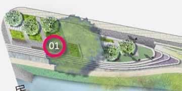
JIALU RIVER ECOLOGICAL PARK
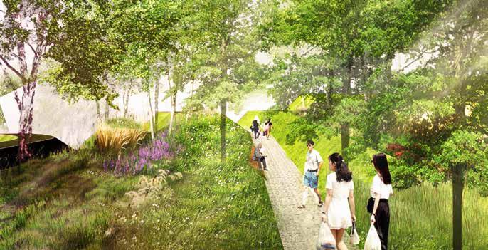
“A LIVABLE, SUSTAINABLE AND ECOLOGICAL RIVERSIDE LANDSCAPE” CONTENT 01
“RESTORING HEIFEI’S ECOLOGY AND AQUAFER”03
16
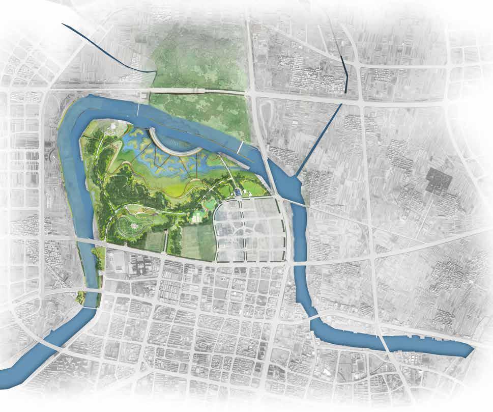
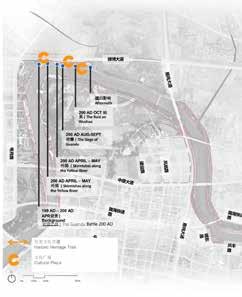
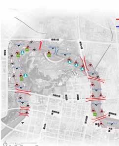
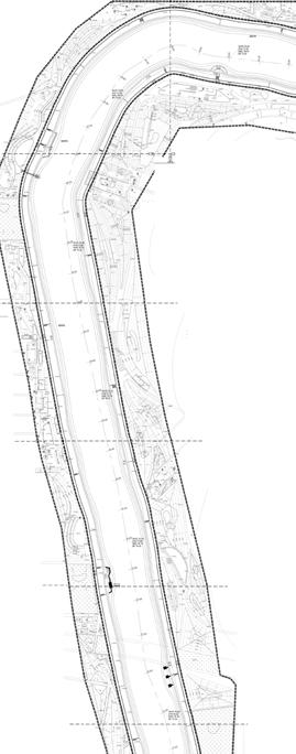
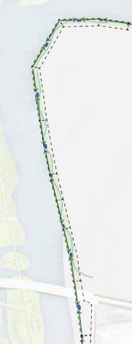
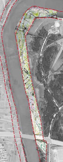
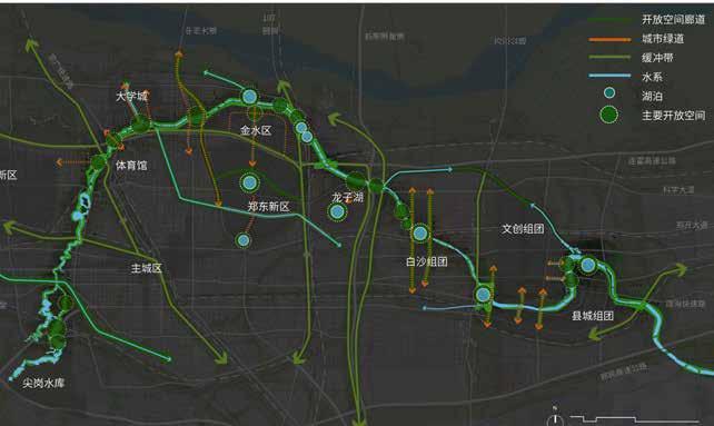
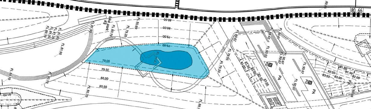
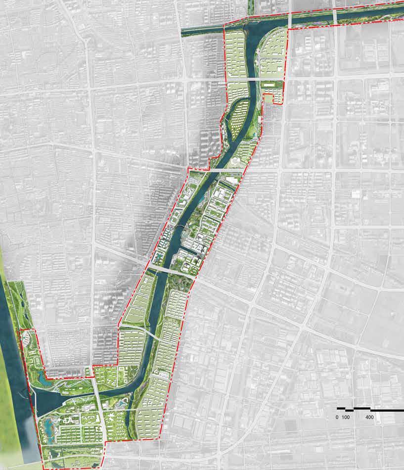
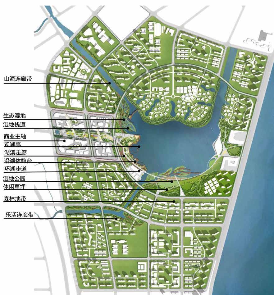
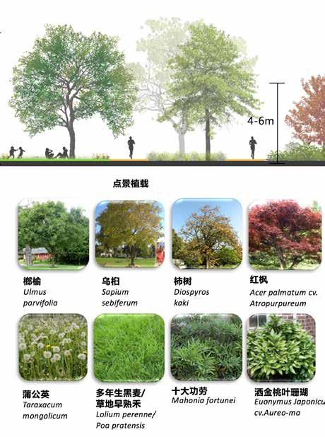
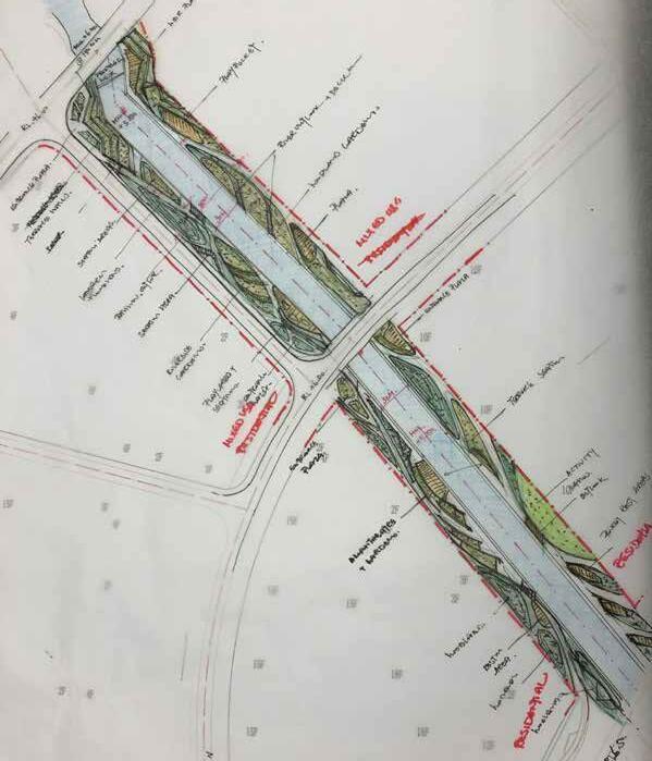
Eachidentity.zone is designed in context to the administrative area’s identity, cultural, and zone function as well as the heritage found on site. The character and identity of Zhongmou in particular is about having a big water effect and sponge city purifcation system to create a sustainable landscape JIALU RIVER ECOLOGICAL PARK | ZHENGZHOU.HENAN | CHINA “A LIVABLE, SUSTAINABLE AND ECOLOGICAL RIVERSIDE LANDSCAPE” >100 HA Overall Landscape Masterplan Image Credit : AECOM HKG + SG + SH 01 CLIENT Yellow River Engineering Consul tants (YREC) SIZE 15km of 60km Scope SCOPE CONCEPT DESIGNSCHEMATICDESIGNDESIGNDEVELOPMENT LOCATION ZHONGMOU, ZHENGHZOU TEAM + CONSULTANTS AECOM HONG KONG AECOM SINGAPORE AECOM SHANGHAI AECOM WUD ROLE LEAD DESIGNER TEAM CO-ORDINATOR DURATION 6 MONTHS STATUS UNDER CONSTRUCTION IMAGE COPYRIGHT AECOM ASIA LIMITED Shang Dynasty Heritage Park Chor Dynasty Heritage ParkDouble Culture Park Innovative Arts Park River Ecological Park Post-Agricultural Park Theme : River Old Town Position : Active/Leisure Theme : Ancient River Position : Eco/Culture Theme : Mother River Position : River Culture Theme : New Innovation Character : Modern/Creative Theme : Agriculture Life Position : Fields/Nature Theme : Big Water Position : Eco/Culture 02 03 04 05 06
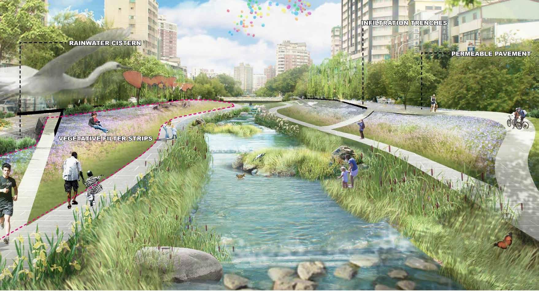
The existing river is a stream that is being harnessed into a controlled river. Our mission was to create an ecological riverside landscape on the two sides of the embankment. for the people of Zhengzhou. The landscape aims to promote an ecological and livable riverfront city imbued with a strong heritage and cultural
Jialu River, like a river scroll meandering east-west through 7 key administrative zones through the new Zhengzhou and ZhongMou areas. It serves as the key connective strand and serve as an important function to the Ecology, Culture and image of the area.
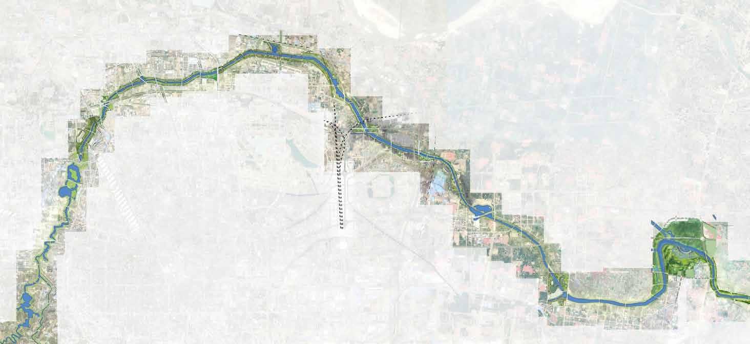
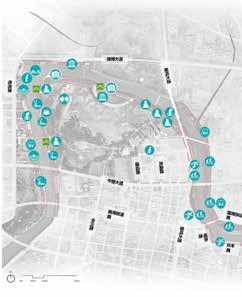
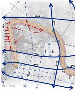
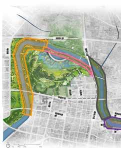
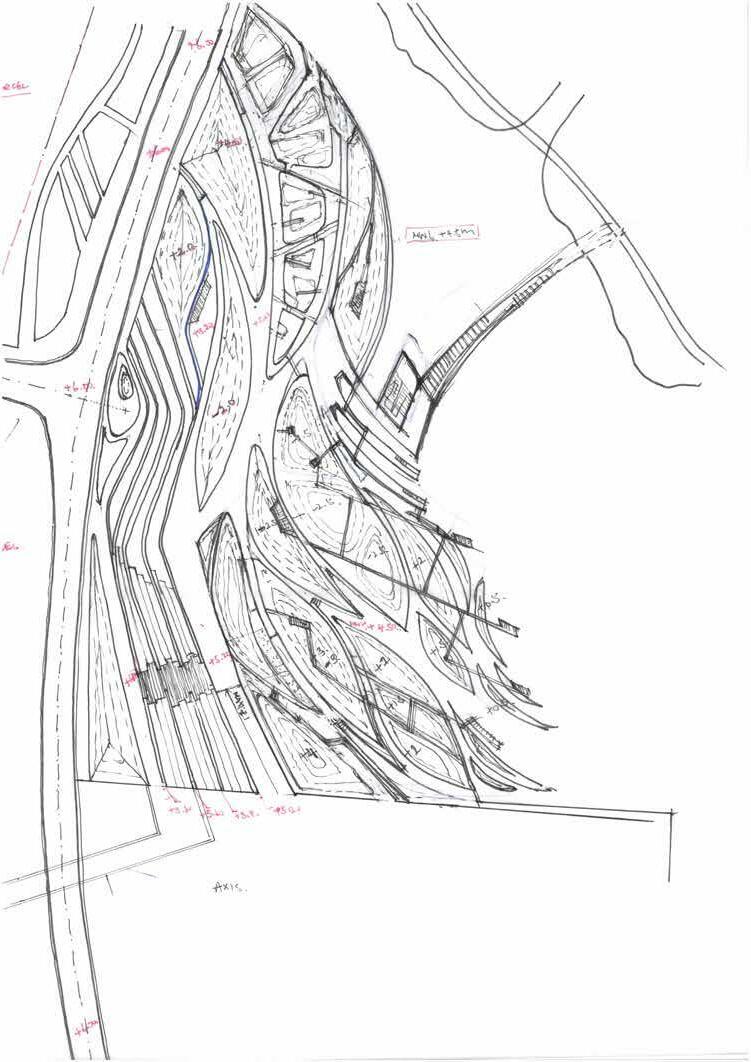
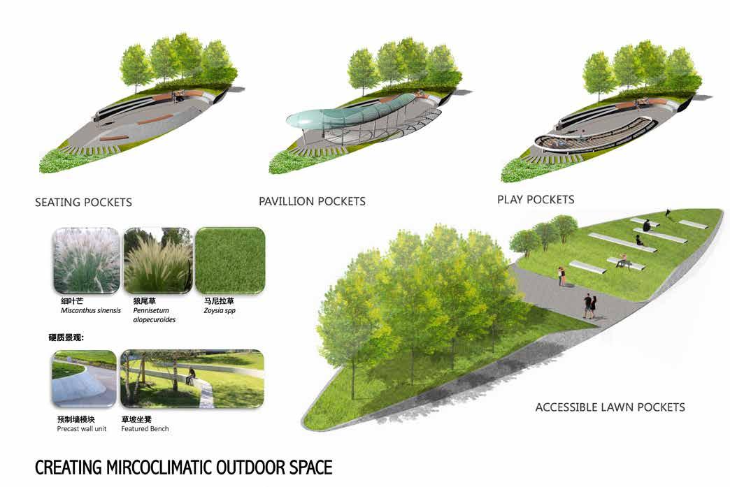
17 The existing site is a vast agricultural land with a few heritage bridgees The site is divided into 4 key zones : Cultural Zone, Ecological Zone, Sightseeing Zone, Community Recreation The site is much above the controlled river dams and have various vehicular bridge underpass through out Establishing a hierarchy of circulation from inland to river edge, and enhancing connectivity throughout 4 zones Diversity of Programme for learning, sightseeing, and experiencing the site through active and passive activities Celebrating the 3 Kingdom Heritage and Culture, as well as the Ancient river drawing pattersn found in the region Existing Site Condition Functional Zoning Level + Grading Circulation Programme Layout Heritage + Culture Overall Landscape Masterplan Cultural Plaza Wetland ActivePassiveViewingHeritageWaveEntranceElevatedEcologicalParksCorridorViewingDeckGatewaysDeckandCafePlazaTowersRecreationSportsArea10090806050403020107 01 02 03 04 04 05 07 06 08 09 101010 10 10 10 05 05 05 05
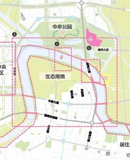
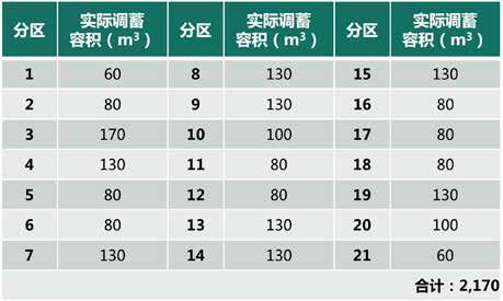
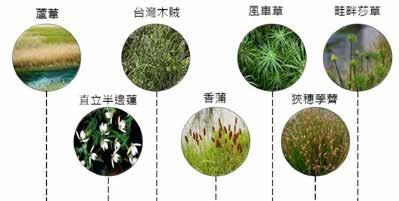
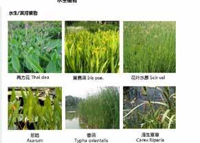
JIALU RIVER ECOLOGICAL PARK | ZHENGZHOU.HENAN | CHINA “A LIVABLE, SUSTAINABLE AND ECOLOGICAL RIVERSIDE LANDSCAPE” >100 HA Zhongmou.andfornaturalnatedparticularecologicalthedeployedThistheintailedprinciplessustainabledesignInwaterresilientandconnectforItCONNECTIVITYECOLOGICALisalsoimportantthe6zonestoecologically,functionasasystemtoconditions.thiszoneouradaptsdesignandde-thespongecitycollaborationwithWUDteam.systemisthroughoutsite,butthiszoneinisdesigtocreateaenvironmentboththenaturethepeoplein Early Concept Sketch DD Layout + Grading Plan WUD Sponge City Plan SD Filtre Pond Calculations Site Wide (60km) Sponge City System Image Credit : WUD Team SPONGE CITY SYSTEM WetlandsRetention Basin Porous DetentionPavingBasin
Rain Gardens
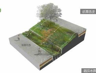
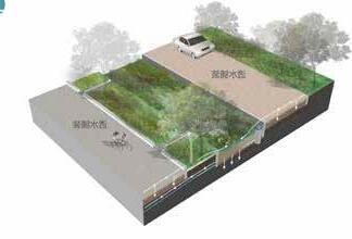
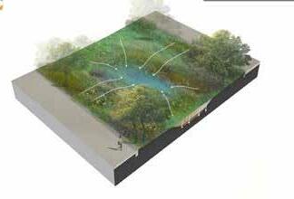
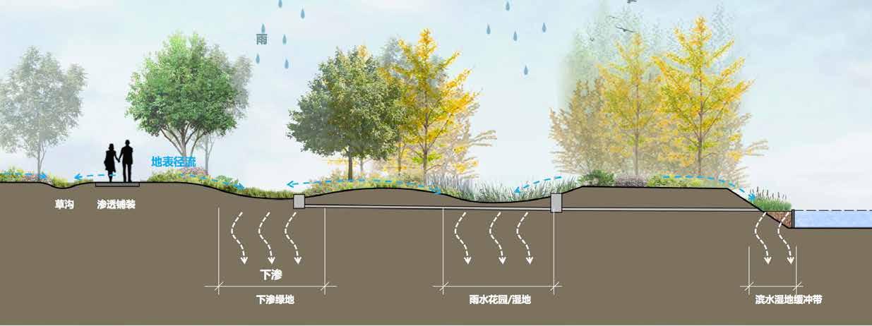
Retention Basins
Grass Swales
JIALU RIVER ECOLOGICAL PARK | ZHENGZHOU.HENAN | CHINA “A LIVABLE, SUSTAINABLE AND ECOLOGICAL RIVERSIDE LANDSCAPE” >100 HA HERITAGE PAVILLIONS JIALU RIVER (HARNESSED) Wetland Pavillions
ECO/RIPARIAN FIELDS VIEWING TOWER (10M) CULTURAL PLAZACYCLE + PROMENADE
this river with a self
The
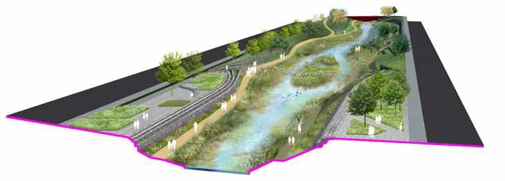
corridor,
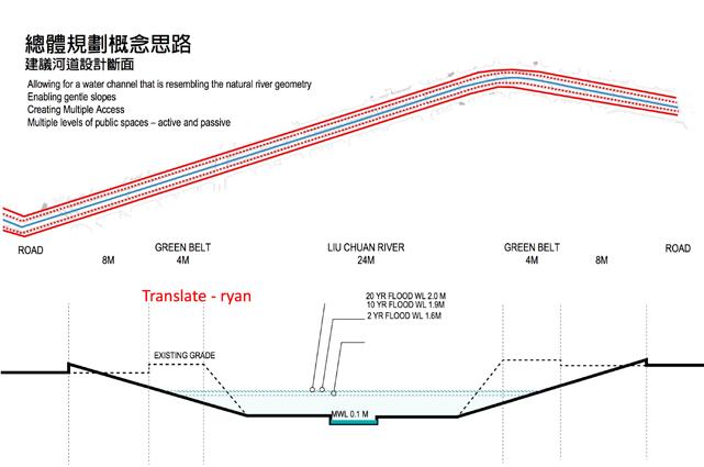
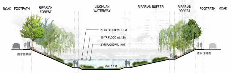
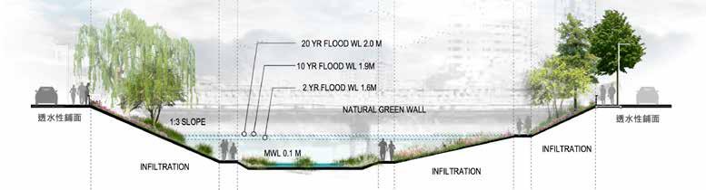
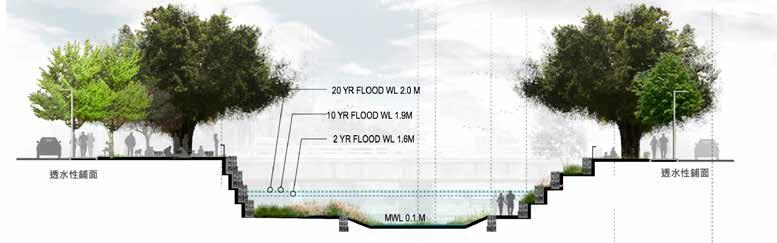
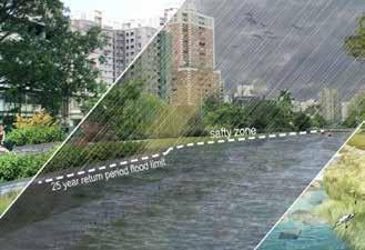
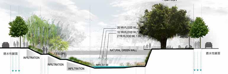
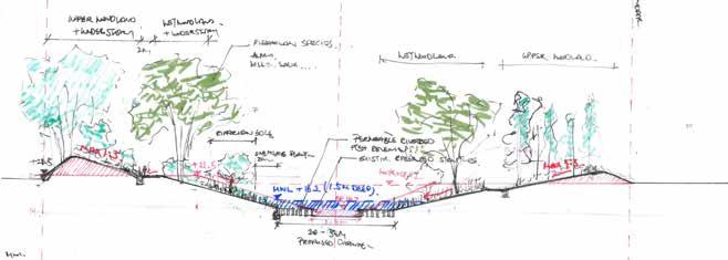
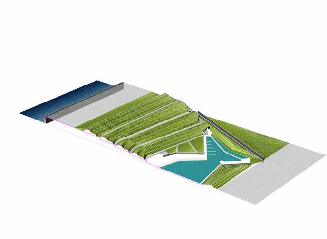
Design Principle Lower Segment | Enhance Natural Wetland Ecology LIUCHUAN RIVER REVITILISATION | TAICHUNG | TAIWAN “RE-EMERGENCE OF NATURAL RIVER COURSE” 01 02 REVITALISE river ecology REGENERATE and give life back to the river of Liuchuan REDEFINE the river back to its natural profle riginal rofle Existing Channel roposed rofle25 YR FLOOD LVL
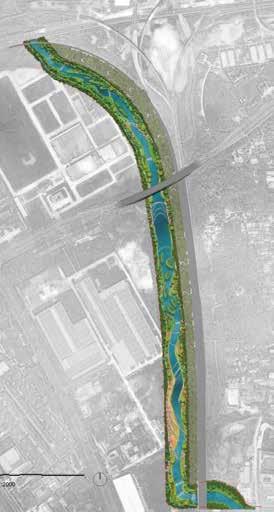
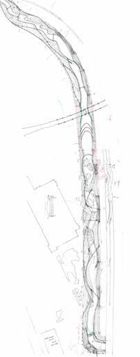
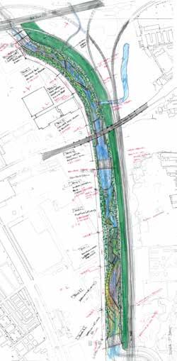
22 >50 HA TAICHUNGCLIENT AUTHORITY CONCEPTSCOPE15HASIZE 2DURATIONLEADROLEAECOMAECOMAECOMTEAMTAICHUNG,LOCATIONDESIGNSCHEMATICDESIGNDESIGNDEVELOPMENTTIWAN+CONSULTANTSHONGKONGTAIPEIWUDTAIPEIDESIGNERMONTHSFORPHASE 1 2 MONTHS FOR PHASE 2 AECOMIMAGEDETAILSTATUSDESIGNCOPYRIGHTASIALIMITED
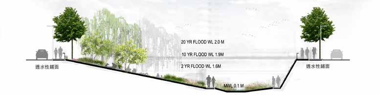
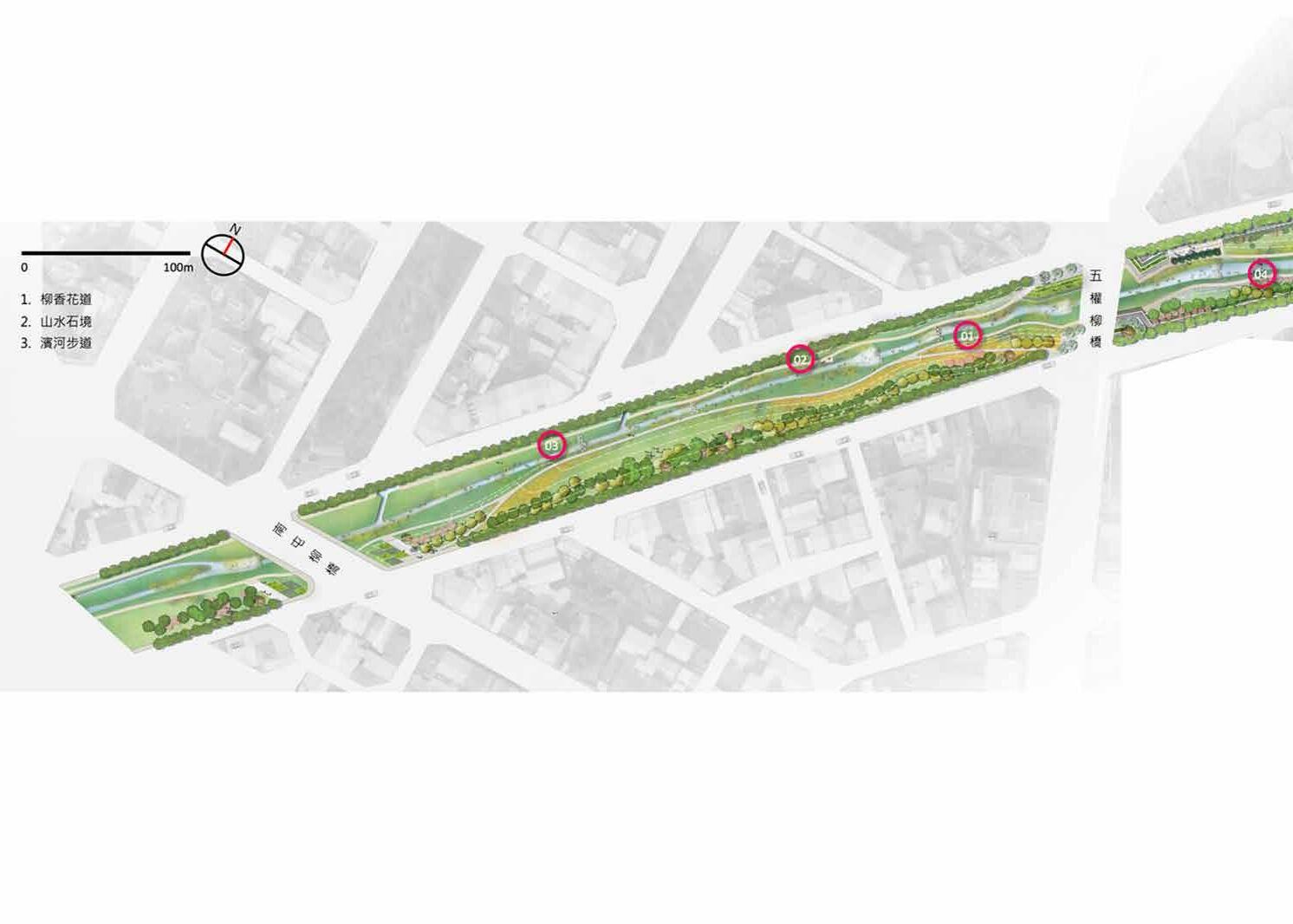
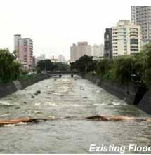
Liuchuan River runs north-south cutting through the city of Taichung Center. Once served as a drainage conduit to the city is today a forgotten concrete channel. project aims to revitalize sustaining water connecting the city north-south as well as east-west of the river, a new ecological threshold for both people and nature. There 3 Key Design Vision in the design:
and
Middle Segment | Artist Culture + Ficus Celebration Upper Segment | Riverside Life and Urban Stage 03 04 05
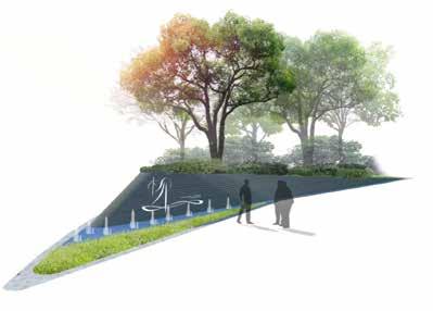
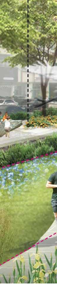
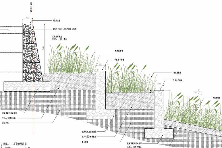
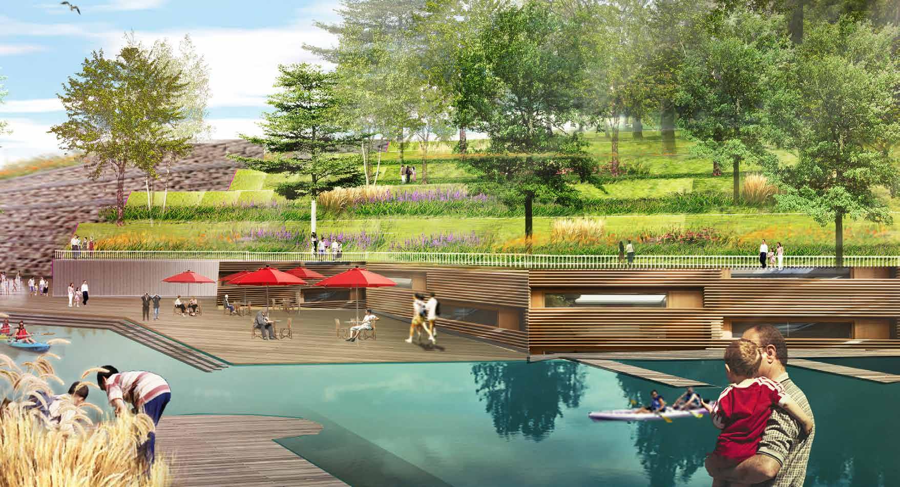
24 LIUCHUAN RIVER REVITILISATION | TAICHUNG | TAIWAN “RE-EMERGENCE OF NATURAL RIVER COURSE” >50 HA Aerial Perspective Render Image Credit AECOM + Outsource Renderer 3/4 Perspective Image Credit : AECOM TP LinZhiZhu Plaza and Ecological Edge Gabion Tier Wall LinZiZhu Plaza Entrance Feature Riverside Walk Filtering Vegetation
|
>50 HA CONCEPTSCOPE3KMSIZEHEFEICLIENTLDI AECOMIMAGEDETAILSTATUS2DURATIONLEADROLEAECOMAECOMAECOMTEAMHEIFEI,LOCATIONDETAILDESIGNSCHEMATICDESIGNDESIGNDEVELOPMENTDESIGNCHINA+CONSULTANTSHONGKONGTAIPEIWUDTAIPEIDESIGNERMONTHSDESIGNCOPYRIGHTASIALIMITED
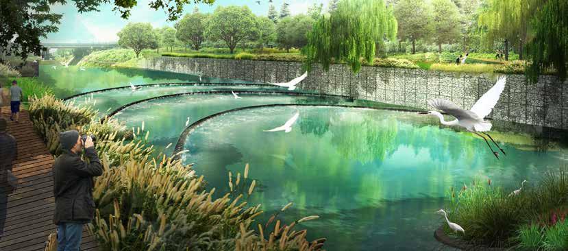
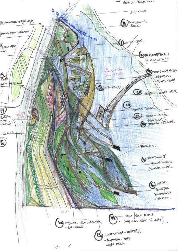
HEIFEI RIVER RESTORATION HEFEI CHINA HEIFEI’S ECOLOGY AND AQUAFER”
The Shi Wu Li River runs from the Swan Lake downstream weaving through various administrative zones. The river is 23 km in total. Our site is a 3km fragment that situates within an existing industrial zone close to a Hefei train station and conditioned by the client as a deep water purifcation zone, with the intend to improve the existing water quality and ecosystem.
“RESTORING
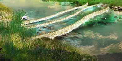
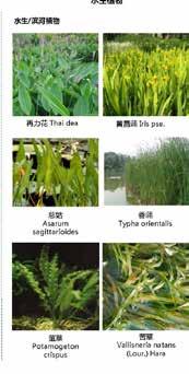
Our Mission in this project is to bring the existing river – which is stream like appearance, back into a natural precinct, through introducing a purifcation pond system and the embankment profle to restore the river.
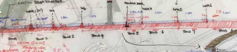
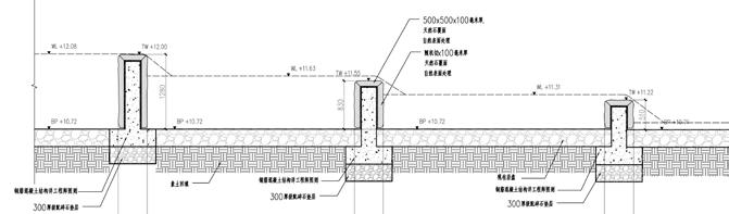
WEIR # LOCATION LENGTH (m) SLOPE DROP BP DEPTH TOP OF WEIR MWL W1 POND 1-2 350 0.08% 0.28 13.72 1 14.87 14.72 W2 POND 2-3 150 0.08% 0.12 13.60 2 15.75 15.60 W3 POND 3-4 200 0.08% 0.16 13.44 1.8 15.39 15.24 Fanhua POND 4-5 250 0.08% 0.2 13.24 1.6 14.99 14.84 W4 POND 5-6 150 0.08% 0.12 13.12 1.2 14.47 14.32 W5 POND 6-7 250 0.08% 0.2 12.92 1.2 14.27 14.12 W6 POND 7-8 200 0.08% 0.16 12.76 1 13.91 13.76 W7 POND 8-9 280 0.08% 0.224 12.54 0.7 13.39 13.24 Critical Design Section Proposed Weir Calculations Filtration Pond System Design Process
|
26
27 Embankment Detail Design Weir Detail Design Vegetation Filter Horseshoe Weir Impresssion Image Credit : AECOM Graphics Natural Weir Impresssion Image Credit : AECOM Graphics
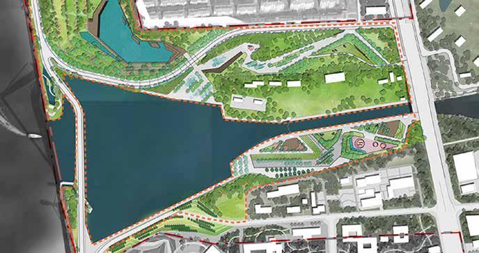
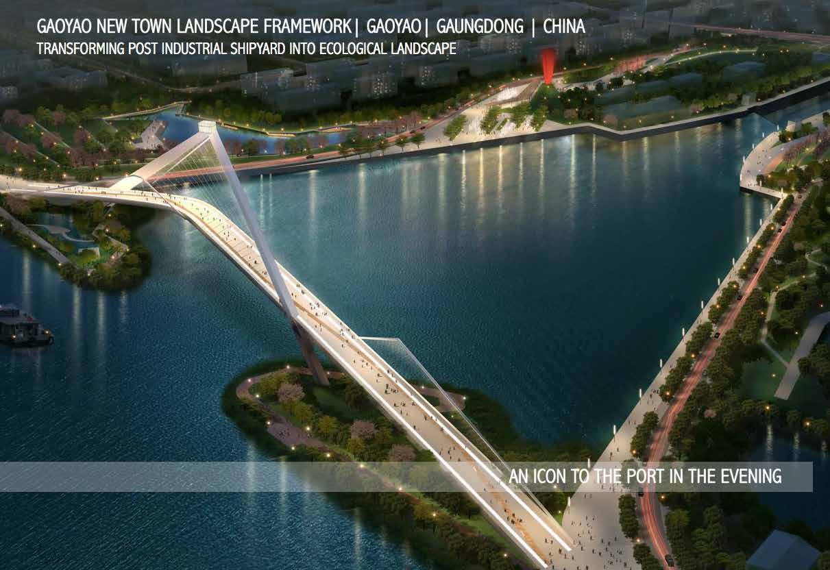
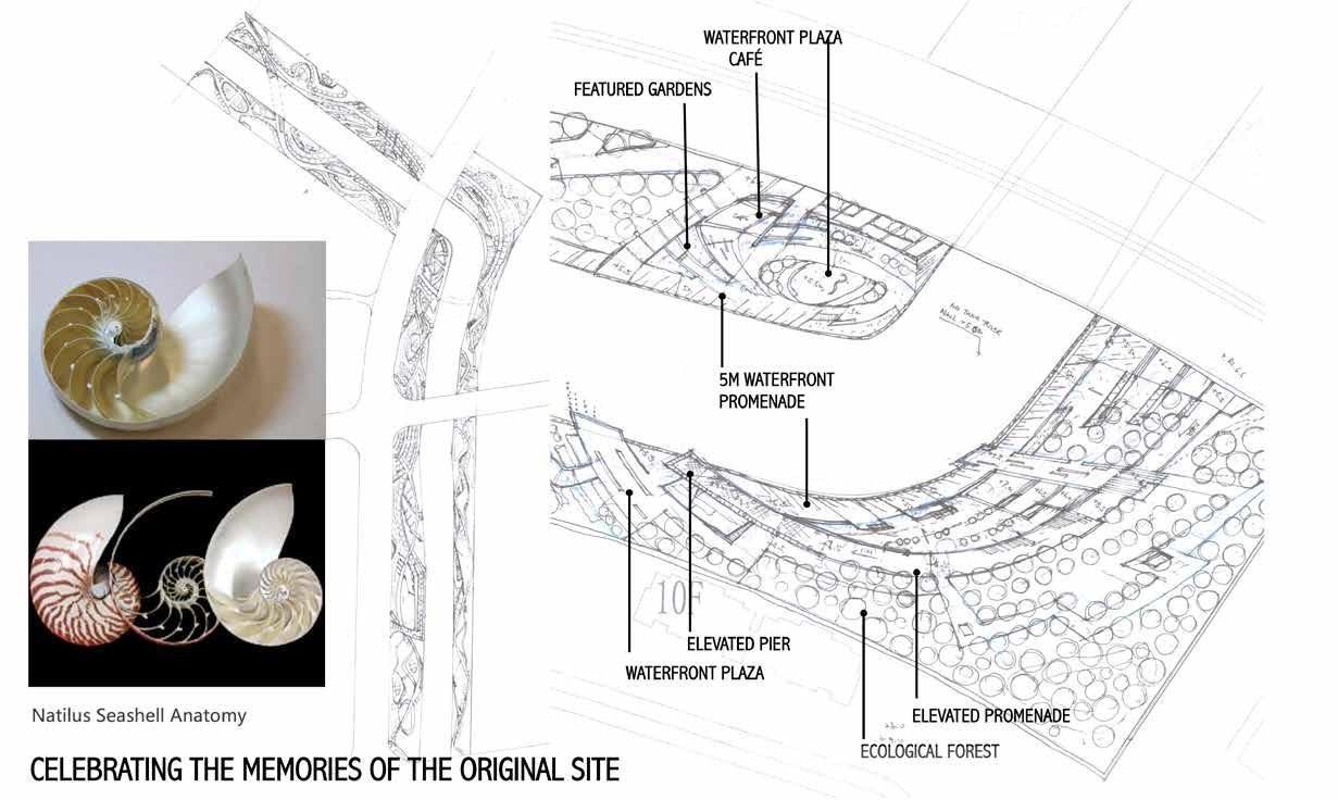
LANDSCAPE MASTERPLAN | GAOYAO | CHINA “TRANSFORMING INDUSTRIAL SHIPYARD TO A POST-INDUSTRIAL LANDSCAPE” >200 HA GAOYAOCLIENT AECOMIMAGECOMPLETEDSTATUSLINES22-3DURATIONLEADROLEAECOMAECOMTEAMGAOYAOLOCATIONDESIGNSCHEMATICCONCEPTSCOPE>200HASIZECORPORATIONDEVELOPMENTDESIGNDESIGNGUIDELINES+CONSULTANTSHONGKONGTAIPEIDESIGNERMONTHSFORDESIGNMONTHSFORDESIGNGUIDE+PLANNINGBOOKLETCOPYRIGHTASIALIMITED
Gaoyao is a in the Yangtze River Delta in the Jiangsu province. The site is adjacent to the Gaoyao Lake, third largest in the province and provides important water resources and aquatic product hence with many shipyards around. While the canal is still being used by cargo’s most of the shipyards are abandoned. Our vision is to transform the industrial shipyard site into a post-industrial landscape park, that is integrated into a comprehensive urban design framework. We generated 4-R as our design vision for the landscape framework the river
28
REVITALISE Embankment landscapes 01 Waterfront Park Schematic Design 02 Crescent Park03 Central Park04 Leisure Park05 Waterfront Park06
CANALSIDE
RESPECT Operating River Channel RECLAIM Industrial Shipyard Sites RECONNECT Two sides of

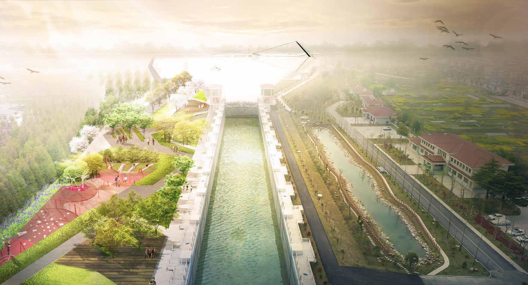
CANALSIDE LANDSCAPE MASTERPLAN GAOYAO| CHINA
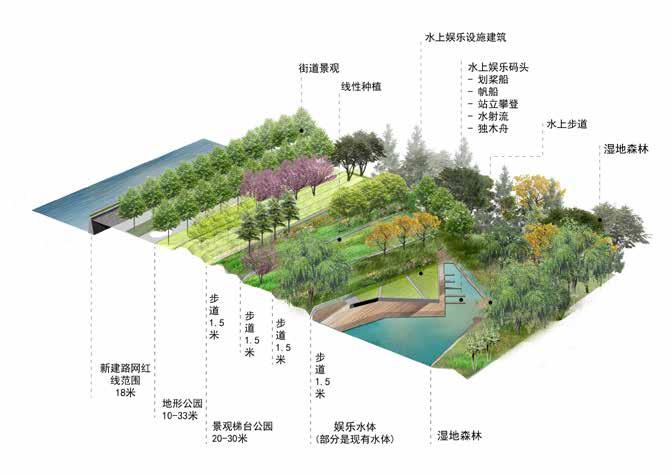
“TRANSFORMING INDUSTRIAL SHIPYARD TO A POST-INDUSTRIAL LANDSCAPE PARK” Terrain Design
|
Natural
>200 HA Form Studies
“TRANSFORMING INDUSTRIAL SHIPYARD TO A POST-INDUSTRIAL LANDSCAPE PARK”
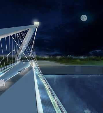
Bridge Impressions through the day
Cross Section Design + StudyForm Study
32 >200 HA CANALSIDE LANDSCAPE MASTERPLAN | GAOYAO| CHINA
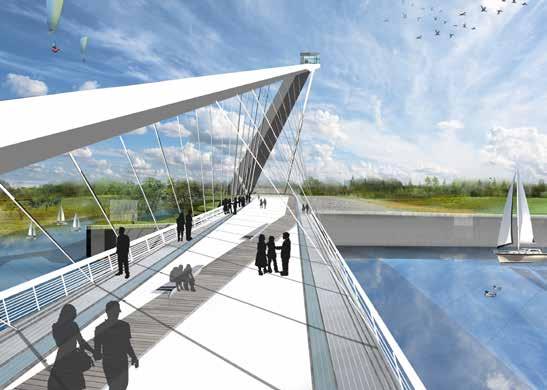
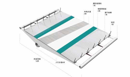
Pedestiran Bridge Concept - Sail
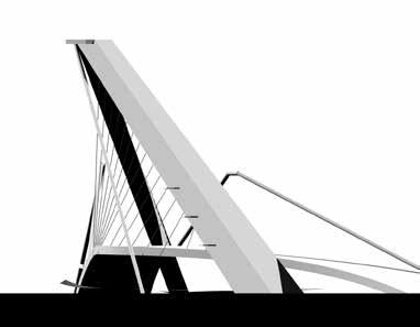

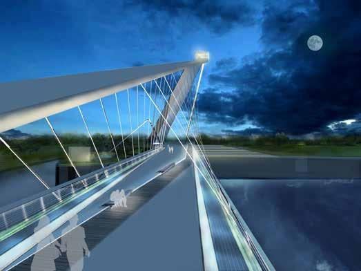
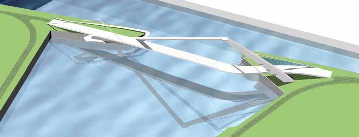
Aerial Perspective Render Image Credit : AECOM + Outsource Renderer
| XIDIAN, NINGBO |
“SUSTAINABLE
34
Xidian, southwest of Ningbo city is a town abutting XiangShang (Elephant) harbor. The existing site is part of the Tie Gang, consist mainly mud fats, crab and shrimp farms. It is a low-lying foodplain at the mouth of the fve-city river.
XIDIAN NEW TOWN CHINA WATERFRONT
Site
The town is full of natural resources and scenic elements, with bodies of clean water and moun tain backdrop, as well as a rich history of fash light industrial manufacturing, Such rich resource inspired our team to propose a sustainable landscape master framework for the new lake town. Understanding and Analysis
AND ECO-FOREST CITY” >100 HA XIDIANCLIENT AECOMIMAGESCHEMATICSTATUSDESIGN23-4DURATIONLEADROLEAECOMAECOMTEAMXIDIAN,LOCATIONDESIGNSCHEMATICCONCEPTSCOPE>100HASIZECORPORATIONDEVELOPMENTDESIGNDESIGNGUIDELINESCHINA+CONSULTANTSHONGKONGNINGBODESIGNERMONTHSFORCONCEPTMONTHSFORSCHEMATICFRAMEWORKDESIGNCOPYRIGHTASIALIMITED
35
The axis that cuts through the town to the waterfront will serve as the people axis, a new mix-used urban landscape.
PEOPLE AND CULTURAL LANDSCAPE
Our vision is a sustainable water and forest city, consisting of purifcation water systems and sponge city design to manage water quality, and create a natural precinct in the waterfront. Along the north and south we aim to create ecological corridors to promote outdoor living.
Wetland + Sponge City Schematic Design Full Color Layout Sketch
SUSTAINABLE WATER + FOREST CITY
Our aim is to create a big water effect and accessible lake front, and a sustainable waterfront landscape for both people and nature, promoting Xidian’s industrial culture and its ecology.
BIG WATER EFFECT
“SUSTAINABLE WATERFRONT AND ECO-FOREST CITY”
36 >100 HAXIDIAN NEW TOWN | XIDIAN, NINGBO | CHINA
37
|
“A
+
>500 HA CONCEPTSCOPE>500HASIZECEDDCLIENT NewLOCATIONDESIGNSCHEMATICDESIGNDESIGNGUIDELINESTerritories,Hong Kong TEAM + CONSULTANTS AECOM HONG KONG DP+E LEADROLE 2DURATIONDESIGNERMONTHSFOR FRAMEWORK 2 MONTHS FOR DESIGN AECOMIMAGEON-GOINGSTATUSGUIDELINESCOPYRIGHTASIALIMITED
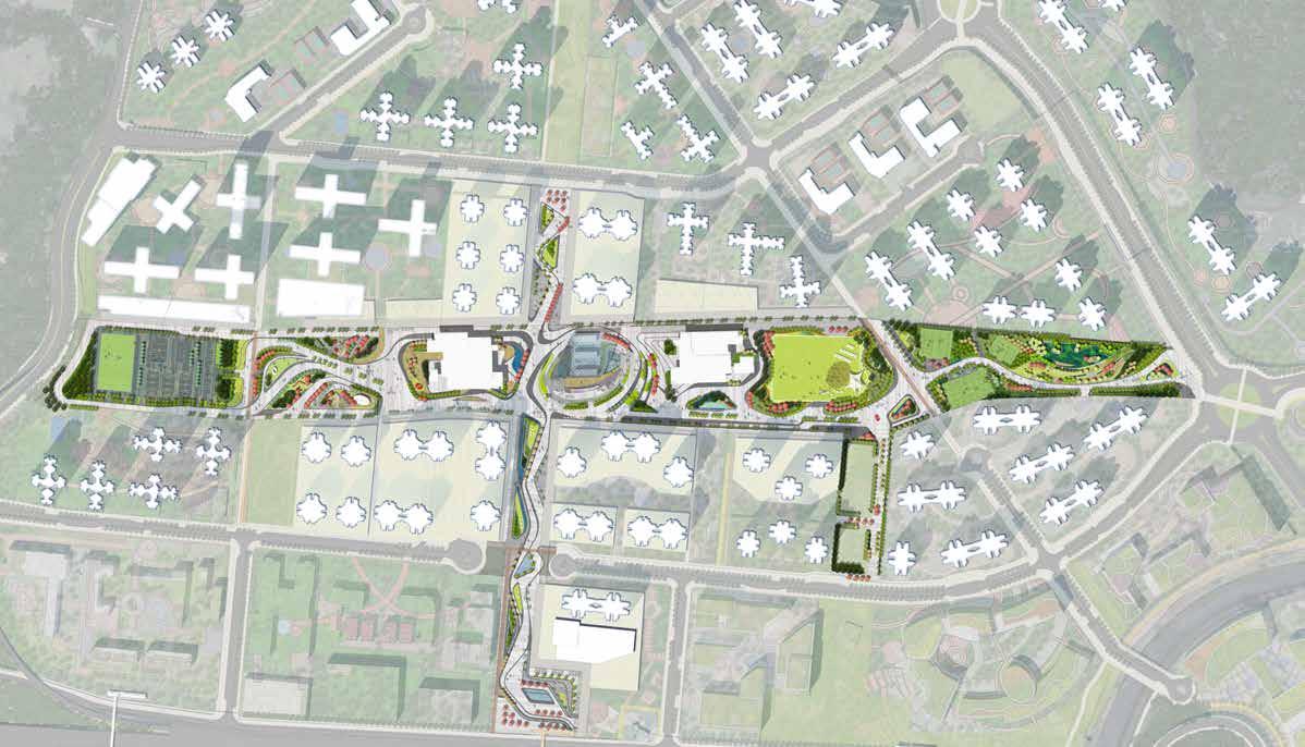
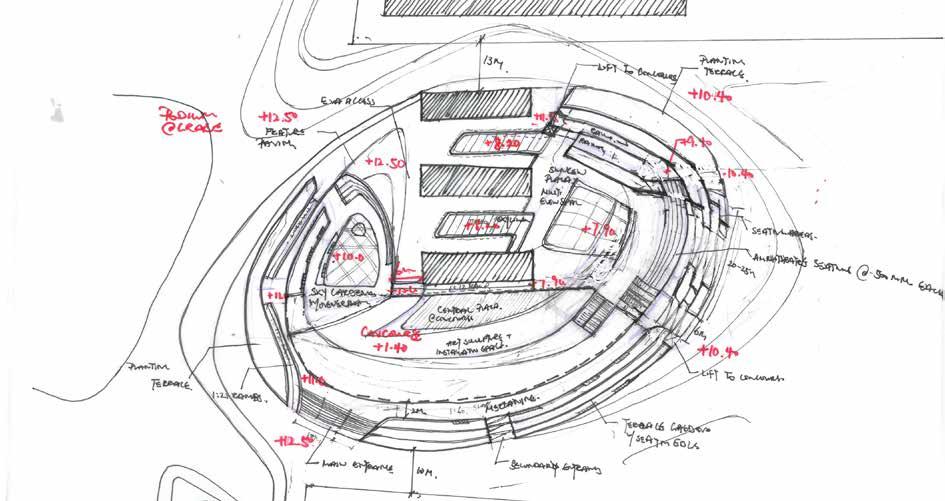
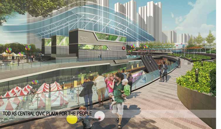
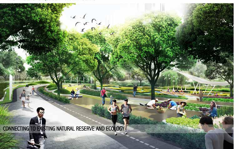
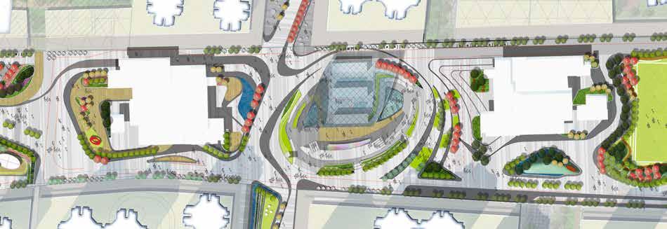
KWU TUNG FANLING NEW TOWN FRAMEWORK DESIGN GUIDELINES HONG KONG TOWN OF UNIQUE CONTEXT IDENTITY AND A DYNAMIC LIVING TOWN”
PLAZA
Where Rural Meets Urban – Unique character to this town and was set out by the client as the overarching vision for the town plaza design
38
+
Kwu Tung Transit Oriented Develop ment, above the proposed MTR Lok Ma Chau Spur Line. Site will serve as the new core town center to the future Kwu Tung New Town
40
41