ADVENTURES NORTHWEST

Exploring Northwest Waters
The Flow


Photos by Jan Anderson


Exploring Northwest Waters

For inspiration, painter Norma Appleton endeavors to capture the beautiful surroundings of the Pacific Northwest during hiking and biking trips. See her work at Whatcom Art Market and learn more at Fine Art America. com>Norma Appleton.

Susan Conrad’s jam is long, slow paddles in long, skinny boats. She’s completed two 1,200-mile solo through-paddles from the Salish Sea to SE Alaska, has authored three books about those adventures, and is working on her fourth. A newly elected Fellow of the Explorers Club, Susan lives in Mount Vernon, WA.
Stephen Grace, Naturalist Journeys’ 2025 Guide of the Year, leads tours worldwide and is an acclaimed author. He explores the Northwest’s natural history through snorkeling, paddleboarding, skiing, trail running, and backpacking.


Cathy Grinstead, born and raised in northern California, spent her summers backpacking in the Sierra. In 2018, she retired from veterinary practice and moved to Bellingham, where she enjoys hiking, outrigger paddling, and snow sports and loves all that Bellingham has to offer!
John Minier is the owner and lead guide at Baker Mountain Guides. Originally from Alaska, he has a deep appreciation for wild and mountainous places. Since 2004, he has worked across the western U.S. as a rock guide, alpine guide, ski guide, and avalanche instructor.


Born and raised in Skagit County, Wyatt Mullen is a landscape photographer and science communicator interested in the impacts of climate and weather on alpine regions. He spends much of his time trail running, skiing, and backpacking throughout the North Cascades.
Mystery and awe inspire photographer James K. Papp’s art. A longtime hiker, he has extensively explored the Cascades Mountain Range’s streams, lakes, and waterfalls. His current photographic project is entitled “Blessings of the Waters.”


A longtime member and chairman of the Bellingham Greenways Advisory Committee, Ted Rosen can often be found on local trails complaining about litter. He is also a skilled guitarist and a student of history
photographs, and videos appear online, in print, journals, reviews, and books. Thomas was nominated for Best Spiritual Literature and the Pushcart Prize in 2024. Learn more at linktr.ee/thomasathomas.


Dana Snyder is a Bellinghambased photographer who has owned her own graphic design business and been a Mt. Baker ski Instructor, Harley rider, South Seas sailor, grandmother, gardener, etc., always with a camera at hand. Her enduring mantra: Life is an adventure!

Christine Smith is the owner/operator of Northwest Navigation/ David B Cruises, expressing her love for adventure and nature by guiding others on unforgettable journeys in Alaska. An author and dedicated naturalist, she lives in Bellingham with her husband, Jeffrey, and three cats.
Thomas A. Thomas is a poet & photographer who has lived in the PNW for 43 years. His poetry,
Paul Tolme, the Journalist on the Loose, is an outdoors writer, award-winning environmental journalist, and blogger for Cascade Bicycle Club. He lives with his wife in a Seattle houseboat crammed with bikes, skis, snowboards, kayaks, and paddleboards, but no regrets. His work can be seen at paultolme.com and cascade.org/news.

The author and publisher of Hiking Snohomish County (2024), Hiking Whatcom County (2023), and Hiking Island County (2025), Ken Wilcox is a long-time Bellingham resident, writer, and professional trail planning/design consultant. Visit him at www.kenwilcox.com

Born and raised in Hawai’i, John Woods moved to Washington State in 1977. Now retired from a career in finance, he is focusing on his lifelong interest in photography after many years of racing sailboats, cycling, kayaking, and hiking.


Cascadia, perhaps more than any other part of the country, is defined by water.
Our rainfall is, of course, legendary and our local volcano Mt. Baker holds the world record for snowfall in a winter (95 feet! in 98-99).
Our glaciers are where the story begins. The North Cascades have the highest concentration of glacial ice in the Lower 48, and these glaciers store immense amounts of water, most of which falls as winter snow. These glaciers release an estimated 230 billion gallons of water to nourish the lowlands each year. It’s not hard to understand the peril we face from the declining volume of ice as the glaciers continue to recede.
eventually surrendering their flow to the vast Salish Sea and the tumultuous Pacific Ocean.
These rivers are the lifeblood of Cascadia, draining the mountains and sustaining the expansive coastal areas of the Pacific Northwest. The grandest of them, the Columbia, is the fourth largest river system in the United States. From its headwaters in the lofty glaciers of the Canadian Rockies, its waters travel more than 1200 miles to the ocean, draining an area the size of France.

These prolific glaciers give birth to uncountable rivulets that gather their icy waters into streams, forming mighty rivers that muscle their way through our great dripping forests,


In our corner of the Range, the Nooksack and Skagit Rivers both support all five species of salmon and transport fresh water to the Salish Sea, supporting the marine ecosystem in crucial ways. We are blessed to live on the shores of this extensive saltwater paradise, home to the idyllic San Juan Islands, orcas, and largely unseen but vitally important eelgrass beds.
And Cascadia is where the fabled inside passage begins, that complicated coastal route that extends for something like 1,000 miles from Puget Sound to Skagway, Alaska. This route is our connection to the North, where wilderness still exists on an almost unimaginable scale.
In this issue, we celebrate this great flow with the intention of both inspiring your own adventures and reminding you of the necessity to protect this absolutely foundational –and fragile–resource that defines our beautiful part of the planet.


One of yachting’s premier events is coming to Bellingham this summer. Race Week, an iconic racing exposition that traces its origins in the Pacific Northwest back to the early 1980s, will make Squalicum Harbor it’s home after four years in Anacortes and nearly four decades on Whidbey Island.
Why Bellingham?
“Anacortes has been a great venue for our event for the past four years,” explains Schelleen Rathkopf, Producer of Race Week. “But we’ve maxed out all the available guest moorage that is available to us at Cap Sante Marina, and we’d like to continue to grow the event and get more fleets involved.”
with other sailboat racing events in the region.

Another issue in Anacortes was timing. Due to scheduling conflicts, Race Week was held on the last week of June, which, according to Rathkopf, proved to be a challenging time for many fleets and families due to conflicts
A hidden gem kind of place... where the flowers throw a full-on color parade, the lakes practically demand a kayak, and even the squirrels look like they’ve got spring fever. You’ll find yourself exploring trails alive with blooms, paddling through postcard-perfect waters, and soaking in a season that feels too good to be real. Pack your sunglasses, a touch of curiosity, and get ready to undiscover Idaho, spring-style.


This year’s event, featuring buoy, distance, and pursuit races, will return to its original schedule, July 21-25.
“We’re excited to get back to the third week of July with our move to Bellingham,” Rathkopf says. “A good chunk of the commercial fleet clears out of Squalicum Harbor en route to Alaska at this time, so this opens up a lot of guest moorage for us to expand and grow. The closer proximity to Canada will also make it easier for those boats coming to the event from British Columbia.”
Fisherman’s Pavillion, a 9,000-squarefoot event space at Squalicum Harbor will serve as the site of the famous post-race parties and the new Race Week Marketplace, an exhibition space for event sponsors and Bellingham business supporters. Opening and closing night festivities will be held at Bellingham Yacht Club, also located at Squalicum Harbor.
Current sponsors of Race Week include Gosling’s Rum, Fisheries Supply, CSR Marine, Port Townsend Rigging, Seattle Sailing Club, Corinthian Yacht Club Seattle, and Ullman Sails. With the move to Bellingham, the Port of Bellingham and the Bellingham Yacht Club will be added to the sponsor lineup beginning in 2025.
“We’re really excited to call Bellingham our new home,” says Rathkopf. “There is so much support for the event coming from the port, yacht club, city and county, that we know we’re going to be in good hands and have the support we need to grow.”
More info: www.raceweekpnw.com


By Cathy Grinstead
With this issue, we debut a new feature in partnership with the Washington Trails Association (WTA). The WTA was founded in 1966 with a mission to mobilize hikers and everyone who loves the outdoors to explore, protect, and champion trails and public lands. We felt it was important for our readers to be aware of their activities and actions since our values and goals are so similar.
On March 18, 2025, join WTA for Hiker Rally Day, an event that happens only once every 2 years. This event connects members of our hiking community with their elected officials to speak up for trails. Ninety percent of Washington residents use trails, and legislators need to hear, loud and clear, that we care about public lands! On this day, you get the opportunity to tell your representatives how vital trails are to you and everyone in Washington. You don’t need to be an expert in public land policy—anyone can be an advocate. For more information and FAQs, go to https://www.wta.org/get-involved/action.

The hike to Point Whitehorn is a delight in any season, a leisurely stroll through luscious rainforest to a rocky beach that invites extended exploration. But it’s especially sublime in spring when the forest comes alive after a long northern winter. Three-quarters of a mile of walking through the effervescent greenery will bring you to the captivating shore of the Salish Sea. But don’t stop there. Explore the complicated coastline – during a favorable tide, it’s accessible for miles. On a clear spring day, the wide-open vista of sea and sky enlivens the soul. We have the Whatcom Land Trust to thank for this gem.
Trailhead: From I-5, take Grandview Rd. west (it becomes Koehn Rd.) for almost 9 miles to the trailhead parking lot near the end of the road. No Parking Pass Required.
For a maximum dose of wide-open space in springtime, Dungeness Spit is hard to beat. In fact, it’s the longest natural sand spit in the U.S., extending out into the Strait of Juan De Fuca for 5.5 miles, affording opportunities for some sustained quality time contemplating the Salish Sea. The lighthouse, which marks the hike’s turn-around point, is one of the oldest in the Pacific Northwest, operating continuously since 1857. Planning your visit during a low tide is recommended.
Crescendo: Friday, April 25. This symphonic celebration of Washington landscapes takes place at Benaroya Hall in Seattle. You’ll be treated to a beautiful evening of nature and sound, with live music performed by the Northwest Symphony Orchestra accompanied by photos from WTA’s Northwest Exposure Photo Contest. This event supports WTA’s work to ensure there are trails for everyone, forever! If you attended last year’s event, you’ll know what a special evening it is!
More info: www.wta.org
Trailhead: Dungeness National Wildlife Refuge, at the end of Voice of America Road, off Kitchen-Dick Rd., five miles from US-101 near Sequim. Refuge Entry Pass (available at the trailhead) Required.

This easy and delightful 2.4-mile loop in Guy Talbot State Park in the western Columbia Gorge offers close-up views of Lower and Upper Latourell Falls, one a plunge the other a horsetail. Both are magnificent in spring. The trail winds through a forest of epic cedar and fir and vibrant green moss and fern gardens, gaining a scant 600 feet along the way.
Trailhead: From I-84 in the Columbia Gorge, take exit 35 near Corbett and drive west for 10 miles on the Historic Columbia River Highway to the trailhead parking area. No Parking Pass Required.


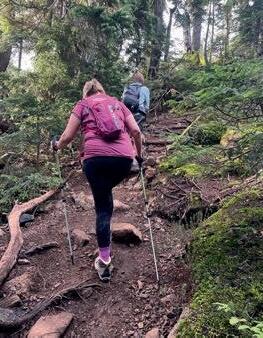
Story by Stephen Grace
You want to keep moving forward, but shrubs form a wall at the forest’s edge. You see no way in. As you explore the tangled greenery, you push and probe. Two branches swing open like doors—the first with a gentle push, the second with a vigorous shove. The branches close behind your back as you wander into the mansion of the forest, entering hidden rooms. Trees rub their trunks together, creaking like the boards of a haunted house. You laugh to calm your nerves. Your spine and stomach are alive with fright. But you press on, deeper into the mossy damp because your curiosity is larger than your fear. You need to know what lurks in the dark.
“We don’t stop playing because we grow old; we grow old because we stop playing.” This quotation is usually attributed to Irish playwright George Bernard Shaw but is tricky to pin down. American psychologist G. Stanley Hall wrote in 1904, “Men grow old because they stop playing, and not conversely, for play is,

gers over velvety moss. Feel the lace of ferns. Touch the corrugated bark of trees. Breathe in air spiced with cedar and sap. Light pours between trunks, pooling among shadows. Through an opening in the canopy above, rays slant toward the ground, spotlighting a couch made of moss. This plush furniture invites you to lie down. Press your cheek to the soft upholstery and listen to a liquid song.
The voice of a Swainson’s Thrush is an ethereal flute that spirals upward and fades, as if pointing toward a place no mortal soul can go. As you close your eyes and listen, your body sinks into a soft mound, and your feet slip into a pit.
Secret entrances appear. Arched passageways and vaulted halls. Amphitheaters. A temple built of trees, a Parthenon painted every shade of green. Monuments made of sunlight and shadow shift as clouds morph overhead. This forest has existed forever, it seems. Yet, every moment, this place is made anew by changing light. The trees are solid, their wood as real as stone. But in the spaces between them, your imagination can slither and soar. In the forest, you may be an emperor or sage. Reach toward the ground and grab a stick. Lift it to the sky. This staff you wield makes you a wizard. Anything is possible among the trees.
at bottom, growth, and at the top of the intellectual scale it is the eternal type of research from sheer love of truth.”
Regardless of who first said, “We grow old because we stop playing,” we should never stop saying it. And we should ensure that forests exist in the world so we never stop following our curiosity, never stop pursuing “research from sheer love of truth.” To take forests away from adults is a tragedy. To steal them from children is a crime.
And we must do more than preserve these temples where the imagination plays. We have to make sure all can enter.
Enter the forest and draw your fin-
The floor of this ancient forest is lumpy with hillocks—an intriguing landscape of pits and mounds. How was this playground created? Pits open when wind-thrown trees rip their roots from the earth. Mounds form when soil and moss blanket upended root balls and bury fallen trunks. When you walk over a mound or tightrope your way along a fallen tree, using its horizontal trunk like an elevated runway, tread cautiously. Avoid stepping through holes in decomposing wood—these gaps can open like trapdoors beneath your feet.
And mind what you grab: handholds that seem solid could be soft with rot, too weak to hold your weight. The path you forge is filled with danger and delight, never dull. Every walk in the woods is an
adventure when curiosity is your guide. Look for the fruiting bodies of fungi known as conks. They grow in horizontal shelves on trees, both standing and fallen. Conks are as solid as ladder steps and can be gripped like handholds as you climb a log. But some conks have surfaces so slick they seem to have been smeared with lacquer by mischief-makers in the woods. Your shoes slide off as you ascend, and your hands cannot hold them—no matter how tightly you grab the conks, they elude your grip. This happened to you in a dream; now it is happening in the forest. You are desperate to hold onto what you love, but everything slips away. The people you care about pass on. The woodlands where you go to grieve could be razed at any time.
Save this stand of trees so that others may seek solace and inspiration here, as you have. Keep this last remnant of ancient forest from slipping away so that others may enter the temple. So that others may heal in this place.
Another forest dream: A root wad from an upended tree presents a climbing challenge, like scaling a cliff, but this obstacle also offers strange rewards. Rocks wrapped in the tree roots look like eggs clutched in the talons of a prehistoric beast. Or amulets seized by the bony fingers of a witch.
these stones into the abyss.
This pit formed when a tree that grew for centuries fell, wrenching open the earth. Centuries may pass before the forest fills this gap with soil.
After a rainstorm, the pit becomes a pool. You slip into the water and float with newts. The water is warmer than the forest air. The newts don’t seem to mind you joining them. With legs splayed and toes extended, these creatures look as though they are forever falling. They hang suspended in the pool. The water, stained by wood, is as brown as tea. You cannot see the bottom of the pit. You wonder how deep it goes.
immensity.” An immensity that shelters a bear with a blinking eye? An immensity where newts once swam in a pool? There are places in the forest that run deeper than your imagination.
What you learn in the wilds is that the world is larger than you are: more immense than your suffering, greater than your grief. The forests are filled with the sounds of creatures who called and sang long before our species learned to speak. There is music in this temple, and it is sublime.
Not only can this music heal you, it can lift you on feathered wings toward heights you didn’t know existed. Close your eyes and listen as you slip downward toward a dream.

Napping on a moss-covered log in a forest is especially stirring if the soundscape includes a Pacific Wren. When this creature flies on whirring wings, it may seem more like a big bumblebee than a bird. You would hardly feel its weight if it perched in the palm of your hand. Yet the voice of this tiny sprite is so large it fills the forest with song.
The rocks may be thunder eggs: nodules filled with agates. They could be geodes, spheres that cup quartz crystals in their inner caves. Or they could be chunks of jade. Pry these rocks loose from the grip of roots. Glimpse the treasure. Stash it in your memory. Then return the stones to the fingered roots where you found them so they may stir wonder in other curious minds. Or throw the rocks into a pit, a root crater large enough to swallow a house. Make a wish as you hurl
Later in the summer, during a month of drought, you discover that the pool has drained. The moist void challenges you to descend into its depths, as if spelunking in a cave. Put on a headlamp and climb downward, into the earth. Take care that a bear isn’t denning there. A forester said that once, when he peered inside a hollow in the ground made by a fallen tree, he saw the eye of a bear blink open.
While descending into this tree pit, consider a line from The Marriage of Heaven and Hell by William Blake: “down the winding cavern we groped our tedious way till a void boundless as nether sky appear’d beneath us & we held by the roots of trees and hung over this
Why does the Pacific Wren, a bird no heavier than a few pennies, produce a cascade of sound? Birds vocalize not in exultation, as the poets suppose. Many of their calls warn of danger. And what of their songs? Females of many tropical bird species sing, but in northern temperate regions of this planet, males are generally the songsters. Male birds tend to sing for the same reasons that bull elk clash their antlers and silverback gorillas beat their chests: to repel rivals and attract mates.
Birdsong sounds cheerful to our brain, but the voice of a thrush or a wren determines how a contestant will fare in the cutthroat competition to pass genes on to the next generation. If birds made a habit of battling each other with beaks
and claws instead of competing in singing duels, their lives would be much bloodier. Birdsong is a beautiful way to manage brutality.
Is it more than that? I keep up with the latest scientific research on birds. But while walking in the woods at dawn to listen to their music, I wonder if they sing because the splendor of the sunrise invites a response.
Some birds sing duets, and some perform as members of synchronized choruses. A Hermit Thrush, one of the world’s great vocalists, sings in two voices simultaneously—a solo songster produces overlapping notes that harmonize. The music of the Hermit Thrush has inspired symphonies.
When a friend got hearing aids, birdsong stopped him in his tracks on a forest path. Suddenly, he could savor sounds his ears had stopped detecting decades before. Tears blurred his eyes, blinding him because he could hear that sweet music.
Some scientists think our human an-
cestors used song to communicate before language evolved. The vocal anatomy of early hominins suggests they produced a wider range of sounds than Homo sapiens. Also, comparisons with non-human

primates, our closest living relatives, show that they produce a wider range of vocalizations than we do. Maybe we sang like birds before we spoke like humans. Perhaps birds move us because their voices stir ancient memories.
To a modern human mind, bird calls and songs may seem like a beautiful babble, a background of indecipherable
sound. But for most of the past 300,000 years, our species has lived close to the natural world, and fluency in the language of other species meant the difference between life and death.
Our ancestors may have been alerted to predators moving through the brush by tuning in to the calls of birds. Their songs could have led us to water and food and made us aware of changing weather and seasonal shifts. Paying attention to birds may have saved our lives as we coevolved with these winged and vocal beings. Now, watching birds and listening to them enriches our lives, keeping us connected to the last of the wilds as we clearcut the woods, fill the wetlands, and pave the plains.
Our shift to cities is so recent it constitutes a tiny sliver of our evolutionary history, like the last few seconds on a timepiece that has ticked for countless years. Wildlands are swiftly disappearing, replaced by sprawling development. What will become of us as we confine


ourselves to the world we are building? Zookeepers know that animals thrive only in the habitats where they evolved. The more artificial an animal’s confines, the sooner the crazed creature dies.
This isn’t to say we should live naked in the woods. Technology is the inevitable result of the big brain and opposable thumbs that evolution endowed us with, and cities are a natural expression of our gregarious tendencies as social animals. But rare is the person who achieves happiness without following a path that leads through the wilds. And no sage arrives at enlightenment without first getting lost.
The English nature writer Roger Deakin notes, “To enter a wood is to pass into a different world in which we ourselves are transformed. It is no accident that in the comedies of Shakespeare, people go into the greenwood to grow, learn, and change. It is where you travel to find yourself, often, paradoxically, by getting lost.”
After moving to the Pacific Northwest, I lost myself in forest listening. While lying on mossy logs amid the busy silence of the woods, I let my ears sample the soundscape. When I learned to pay attention to birds, my world expanded. Birdsongs that had previously blended in a jumble of background noise started to seem as distinct as the music of Beethoven and Metallica. Each song seemed as real as a rock,


as tangible as a tree. It was as though I had gained an entirely new sense. For years I had resisted birding by ear. Bird calls and songs seemed too vague to mean much, too difficult to discern. But when I started listening to what birds had to say, the woods were forever changed. Whenever I stopped running on a trail and listened, I was transported along a pathway of sound to a realm I hadn’t


known existed. Birdsong showed me a dimension of nature that had remained hidden by my unwillingness to hear.
During moments of intense listening in forests, I journeyed beyond the incessant dialogue in my head, the inane chatter that numbs us to awe. While fully immersed in listening to birds, I lost myself and gained the world. This was the greatest freedom I had found.
But what is this freedom worth if other people cannot follow the path I have pursued?
“Nobody’s free until everybody’s free,” said civil rights leader Fannie Lou Hammer in a speech in 1971, the year I was born. Throughout my life, I have been able to access nature due to characteristics I did not choose. I did not select my genes or the environment in which I was raised. Any of us could have been born someone else. No morally sane society would construct a social system that
allows a roll of fate’s dice to determine freedoms some people enjoy, and others are denied.
Access to wild spaces should be a right granted to all, not a privilege enjoyed by some. No person can fully enjoy nature until everyone can benefit from nature. I’ve taught teenagers who live within sight of wilderness but have not had the opportunity to explore the forests and ascend the peaks. Their bodies and minds have not been able to “climb the mountains and get their good tidings,” as John Muir encouraged us to do. To children born into communities without the economic resources to enter the wilds, the Olympic Mountains of Washington State that these young people see in the distance might as well be the mythic Mount Olympus, home to the gods of ancient Greece. Lofty and inaccessible. Unattainable.
The Greeks gave us the ideal of democracy. Their noble aspiration was marred by barring many people, including women and slaves, from participating


in politics. Democratizing nature by removing barriers to access is a process that must continue until all are free—until all can pursue their curiosity on outdoor adventures. Until all can play in the woods and heal in the wilds. Until all can get lost in na ture so that they may find what is best in themselves.
As a species, we have come a long way from the days when members of the Miwok tribe were displaced from their land to make way for the California Gold Rush and a wilderness pre serve in Yosemite Valley. John Muir called Yosemite “by far the grandest of all the special temples of Nature I was ever permitted to enter.” Not everyone could access Yosemite in Muir’s day, nor can everyone access that temple now. We have a long way to go before all can enter.
Physical barriers like inaccessible infrastructure and lack of specialized equipment prevent people from entering the wilds. Travel costs, limited transportation, and work schedules can be prohibitive. Cultural factors such as lack of inclusivity and fear of discrimination further limit access for diverse communities.
How do we ascend the Mount Olympus of moral progress? How do we democratize nature? Follow one of the paths that have been blazed, or pioneer a trail of your own. Support pro grams in communities that lack access to outdoor adventure. Start an organization that ensures parks and preserves are acces sible to all, regardless of background or ability. Guide children to a wild temple so they can hear the music of birds.


by James K. Papp

Here in Western Washington, perpetual cycles of moisture-laden weather systems move inland from offshore, gifting the Cascades Mountain Range with a bounty of snow and rain that sustains the flora, fauna, and people of the region throughout the year. These images trace water’s dynamic journey from the Evergreen State’s icy mountaintops as it descends through creeks, lakes, waterfalls, and rivers to the saltwater of the Pacific Ocean. Photographing the wild water, framed by trees, hills, and skies in timeless black and white, is a way to take these places home with me.
This area, named
with its


How do cascading waterfalls light such sparks of joy within us? This small, unnamed beauty, located at an elevation of about 1,600 feet along the Glacier Creek Road en route to the Heliotrope Ridge Trailhead, has always captivated me. I’ve often stopped there on the way home from this hike and eventually named it Intimate Falls. Forest brush fell down on top of it a few years back. Hopefully, it will appear again in all its splendor one day.

Nearly a century ago, engineers constructed the Diablo Dam along the Skagit River, which flows beside the scenic North Cascades Highway, creating Diablo Lake. The purpose? Hydroelectric power. At an elevation of 1,201 feet, it is part of the popular Ross Lake National Recreation Area. Visitors admire the water’s aqua-green hue created by glacial silt that runs down Colonial Creek from lofty peaks above.


Watching a wild river power downhill from the high country during the wet season is exhilarating. Here, along the Mount Baker Scenic Byway at an elevation of 1,059 feet, the easily accessible Horseshoe Bend Trail begins. Visitors watch Nooksack River’s north fork rock and roll through a small chasm westward toward saltwater. Often, hikers see kayakers skillfully navigating the rapids. This is a favorite place to show out-oftown guests the rugged beauty of our region, as it is reachable year-round. Within a tenth of a mile along the trail, there are lovely spots to laze along the river and appreciate deep beauty.
Much of the water that falls in the mountains as snow and rain eventually reaches saltwater. Walking along a rocky beach at low tide is a primordial pleasure in this part of the world. Sea-level scenes like this one at Whatcom County’s Point Whitehorn are typical along the Salish Sea’s wild areas. Barnacle-encrusted beach stones are ubiquitous, and hikers would be wise to navigate them carefully. Visitors might spy herons, seals, otters, and other wildlife.


Washington State Route 11, also known as Chuckanut Drive, is a beautiful scenic byway that never makes the cut in lists of America’s great scenic drives. Perhaps, at 21 miles long, it isn’t epic enough to rate. But as an experiential journey, it is easily one of the finest ribbons of road in the United States. It is a gorgeous drive that transports visitors to some of the most enchanting roadside attractions in the Pacific Northwest.
I may be biased because I live very near the terminus of Chuckanut Drive, and I’ve traveled it many times. For some perspective, I have driven many breathtaking scenic roads in my day, from North America to Europe, the UK, and Japan. I’ve toured mountain passes, spectacular bridges, desert scrub, deep forests, and rugged coastlines.
Story by Ted Rosen
roads, and Chuckanut was no exception. That said, calling the Chuckanut telegraph pathway a “road” is a bit of a stretch; it was a muddy, poorly maintained trail.
In 1890, the pathway was widened for use by light wagons, acting as a modest connector between Skagit County
to their quarry. It was completed in February, easing the transport of rock on the short trip to town.

The rest of the coastal wagon road, then known as the Old Blanchard Road, was functional yet woeful. On the Skagit end, high tide regularly flooded the road. Travelers had to wait out the tide to proceed. The bulk of the route from Colony Creek to Teddy Bear Cove was a rutted, muddy mess. To make matters worse, in 1901, Skagit County sold the southern three miles of the Old Blanchard Road to the Great Northern Railroad as a cutoff for their Burlington to Bellingham rail line. It seemed this would be the end of the great coastal connector.
All this, and I still rate Chuckanut Drive as one of the most glorious byways, not just in America—but in the world. And it’s right here, in our backyard. Let’s look at this road’s history; then, we’ll take a quick tour.
The creation of Chuckanut Drive can be traced back to 1864 when a new telegraph line ran along the Chuckanut coast. Telegraph lines require telegraph
and Fairhaven. Back then, the only other connector between Whatcom and Skagit was the Old Samish Lake Road, a primitive horse path through thick forest. The coastal wagon road, if improved, could become a viable link for Whatcom residents, whose only methods of connecting to the rest of the USA were by horse or by sail.
In 1891, Whatcom County approved the construction of a hardened road along the telegraph wagon road from Fairhaven to the county line near Clayton Beach. In 1892, using their own funds, the owners of the Roth Rock Quarry (what we now call Teddy Bear Cove) commissioned a team to pave the road from Fairhaven
The sale was disastrous, but Whatcom County was a very vocal community. Whatcom residents raised a hue and cry to reclaim Old Blanchard Road. The May 18, 1905 edition of the Anacortes Telegraph proclaimed:
“It is out of the question for the isolated people of Whatcom County to get into the United States on dry land without driving through Skagit County, but there is no roadway connecting the two counties. Of course, Whatcom County has roadways extending into the British Columbia territory, but it is not to be presumed for one minute that this important province of Great Britain would be willing to annex this adjacent territory.
Therefore, Bellingham and Whatcom County is an isolated community. It is practically cut off from the United States, and British Columbia wouldn’t claim them for anything in the world.”
As the automobile and bicycle became popular in the United States, Bellingham business partners Cyrus Gates and Charles X. Larrabee lobbied Washington state to commission a proper coastal road to replace the Old Blanchard Road. They felt it would be a great scenic drive and a vital economic link for Skagit County farmers.
The Anacortes Weekly American agreed, writing in April 1907: “Those fellows up that way are determined to have that little lover’s lane and automobile path to Chuckanut Bay and the oyster beds if it takes all summer. Well, it is all very well, let ‘em build it, so as Bellingham can give us a market for our surplus cattle, oats and hay.”
Unable to fully commit the manpower, the state eventually signed a contract with builder S. Murchison. His team widened the road from 16 feet to 20 feet and constructed concrete trestles and retaining walls on some of the hairier parts of the roadway. It was painstaking
bicyclists who enjoyed the scenic ride. It took another sixteen years to replace the old wooden bridges with concrete spans over Padden Creek, Oyster Creek, and Blanchard.
Chuckanut Drive was now a popular and critical highway for both recreational touring and Skagit-Whatcom commerce. But its status would soon be usurped by the new U.S. Route 99, wending its way from Burlington to Alger, along Lake Samish and Lake Padden, and north into Bellingham.

progress, with workers blasting and cutting into the stone ledges, then carefully hauling away each giant block for disposal or re-use.
Construction began in 1910, using convict labor at a camp on Oyster Creek. The convicts cleared only about a mile of usable road before the money ran out. After public pressure, the state Highway Department commissioned the Quigg Construction Company to finish four more miles of the road in 1913. They did this, sloppily, raining enormous rocks onto the railway below, stirring an angry Great Northern Railroad to sue the state. The state settled and decided to do the work itself rather than rely on inept contractors.
The Highway Department and its contractors finished the road in 1916 when it was officially made part of Pacific Highway 1, stretching from the Canadian border to San Diego, California. It was still mostly gravel, with a few sections properly paved, but the road was finally opened to automobile traffic. At the time, Chuckanut Drive was the only segment of the Pacific Highway to parallel the Pacific Ocean directly.
The full paving of Chuckanut Drive from Fairhaven to Blanchard wouldn’t be completed until 1921 and came as a huge relief to the growing population of
Completed in 1931, Route 99 was the modern solution, and it relegated Chuckanut Drive to being what it is today: a byway. With the loss of its prestige, attention and investment became precarious. Severe landslides occurred in 1930 and 1937, but road crews addressed them within days or weeks. A massive landslide in May 1976 nearly doomed the road to permanent closure. A portion of the road near Clayton Beach that had settled and cracked two years prior finally gave way. That section of Chuckanut Drive completely collapsed and fell down the mountainside.
There was talk of abandoning the entire road project. It seemed the forces of nature and physics would make the scenic drive a poor investment. Perhaps this panoramic jewel was simply too expensive to keep.
In the end, democracy prevailed. Public cries to rebuild the road fell on

ears beholden to voters, and the laborious task of rebuilding Chuckanut Drive commenced. It took five months of painstaking labor. The Tripp Construction Company carried away massive chunks of rock, hauled in untold tons of fill to bolster the new roadway, and then constructed a concrete retaining wall anchored to the cliff with massive metal bolts. The road was officially re-opened in October of 1976.
Chuckanut Drive still suffers from regular rockfall. These incidents close the road for days, sometimes weeks, but the road always re-opens due to its evergrowing popularity as a scenic drive and the fact that many motorists depend on it for commuting.
Chuckanut Drive remains an aweinspiring experience for locals and tourists. Leaving Fairhaven, you can visit Arroyo Creek or the bucolic fields of Woodstock Farm. Then comes Teddy Bear Cove, where the nudists that once gathered there may have fled, but the stunning rocky shorefront remains. As you pass Hiline Road, you descend into thick forest, where a cathedral of green hugs you close, and sunlight dapples in


starry strobes.
Further on is Larrabee State Park (the first state park ever designated in Washington!) with its campground, easy trails, and half-moon beach. To the east is the busy Fragrance Lake Trail, a beautiful day hike with a spectacular overlook as a reward for your labored climbing.


The Lost Lake/Clayton Beach Trailhead lies a bit further south. From here, a newly re-engineered trail transports hikers three-quarters of a mile to beautiful Clayton Beach, one of the finest places on Earth to watch the sunset on a summer evening. A Discover Pass is required to park at both the Fragrance Lake and Clayton Beach trailheads.
Further down the road, you’ll find Dogfish Point and View Point, which offer drivers a chance to pull over and see the spectacular coastal vistas without needing to hike anywhere.
As you venture further, it’s a good idea to slow down for the narrow cliffside section and the radical hairpin turn at Taylor Shellfish. If you survive that, you’ll find yourself at the Oyster Bar, whose fine seafood warrants a stop. Those more prone to packing gorp in a backpack should head up the Oyster Dome trail, where a long set of arduous yet pleasantly forested switchbacks lead to the Samish Overlook, where you might see some hang gliders taking off for a long soar over the Skagit flats.
Finally, you blaze south to the elegant Chuckanut Manor restaurant and over the Colony Creek bridge, where the for-


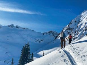
By Wyatt Mullen
Spring is timeless in the North Cascades. Where does it begin, and when does it end? Does it rise with the wildflowers on the eastern slopes and tumble with the last trickle of melted snow? Does that mean spring never arrives on the summit glaciers and never fades in the lupine fields? Is it the heat of the sun or, the fall of snow, or a thunderstorm downpour? Whatever and whenever it is, spring is a time of change and an opportunity to cherish the full range of the montane experience.
Visit AdventuresNW.com to view an extended gallery of Wyatt’s photography.
See more of Wyatt Mullen’s photography at: wyattmullen.com


Story by Ken Wilcox
Inoticed once that if you turn a map of the Salish Sea about 90 degrees counterclockwise, squint with one eye, and allow for some abstract deformity, the general outline of our great inland sea resembles the head and neck of a great blue heron. Vaguely anyway. It’s not a bad metaphor in a place with so many of these iconic birds.
On my crooked imaginary map, the stately bird’s broad beak (Georgia Strait) points left toward Canada. The occipital plumes behind the head are the waterways that gather around Whidbey Island, where tides ebb and flow like a heartbeat through Puget Sound and Hood Canal. Rising from the Pacific Ocean, the gently curved neck leads up the Strait of Juan de Fuca to the bird’s eye, the San Juan Islands.
So, beak, occipital, neck. Viewed from Low Earth Orbit, that’s more or less how I imagine the sea’s amorphous geography. Or maybe it’s just a sprawling blob, a cosmic heron splat, with an annoying international boundary running through the middle.
To the Coast Salish people, these waters were their superhighways, main
villages once lined the more than four thousand miles of coastline surrounding this great inland sea.

drags, and backroads for thousands of years. Wide open, uncrowded, entirely free of stop signs and parking meters. Countless Native American camps and
Today, we can hustle about the region in our noisy boats or motorized land canoes to reach many of the same places that others hunted, fished, and enjoyed for millennia. If we’re lucky, we might even stumble on places that remain virtually unchanged from what the true canoe people experienced centuries ago.
To really get to know our inland sea, maps are one thing, but there’s nothing quite like a good walk on the water. Not in the biblical sense, but in the wait-for-thetide-to-go-out-and-take-astroll sense.
In any case, here are some personal favorites among the largest, most accessible islands in our northern waters:
Possession Point State Park (south of Clinton)
Our timing on a midday Tuesday in January couldn’t have been better. Clouds parting. Sunbeams illuminating the sheer bluffs—outbound tide. Eagles chittering. Sea lions puffing and bobbing for brunch. A fine place to imagine the untrammeled wildness of the Salish Sea coast long before the arrival
of Euro-Americans. And just us to soak it all in. (Expect some company in nicer spring weather.)
The ebbing tide was around five feet when we visited, and we had no difficulty reaching the park boundary in just 0.3 miles. The bluffs are prettiest in morning light. Dangerous slides can happen, so stay back from the base.
The park is a short drive from the Mukilteo-Clinton ferry dock. Follow SR

525 west 1.5 miles, go left on Campbell Rd. and left on Cultus Bay Rd. Continue on Possession Rd. to a hairpin turn, then take the first right onto S. Franklin Rd. (The second right goes to Possession Point Waterfront Park, managed by the Port of South Whidbey.) Limited parking; Discover Pass required.
For just the beach, descend the path on the left. If you’re up for a steep, twisty-turny hike to a view of Puget Sound and Mount Rainier, take the path on the right for a 1.4-mile loop. The loop descends to the same pebblecobble beach. Continuing on the loop, look left for Mount Baker, with snowy Three Fingers and Whitehorse
Mountains rising above Possession Sound.
In the spring of 1792, Captain George Vancouver claimed “possession” of these lands and waters for King George III. The native people later responded, “Vancouver failed to realize that these lands had been the Northwest Coast natives’ homelands for thousands of years and were not available as a birthday gift for the King.”
With a walkable beach more than two miles long, Double Bluff is an easy add-on to a visit to Possession Point, best, of course, during lower outgoing tides. This Island County Park is pet-friendly and mostly off-leash (beyond the wind sock). The modest parking area fills up on nice weekends any time of year. From the Clinton ferry dock, take SR 525 for 10 miles and turn left on Double Bluff Rd. The park is two miles ahead.
With or without Fido, the beach offers an excellent stroll below eroding mega-bluffs over 300 feet high and a soothing place to putter. Just do your puttering away from the base and keep an eye on the tide tables if you venture far. Shutterbugs might prefer morning sunlight on the bluffs and the Olympic skyline, although winter/spring sunsets can also be quite fabulous.
An interpretive sign tells the story of how the bluffs were originally deposited by massive glaciers and worn away by the sea for thousands of years. The higher easterly bluff diminishes in height after 1.5 miles. Just around a sharp point, the northerly bluff begins to rise.
Useless Bay riffles to the southeast, with a proud Mount Rainier (or Tahoma, the “Mother of Waters”) dominating the horizon. If it’s clear enough, you might notice downtown Seattle’s spiky cluster of buildings. At lower-low tides, the sandy beach extends far from shore into Useless Bay—“useless” only because it’s too shallow for ships. Canines (and their owners) will heartily disagree.

Ebey’s Landing (Coupeville area)
Perhaps the best-known seashore on Whidbey Island, Ebey’s Landing National Historic Reserve near Coupeville is also among the most heavily visited, with up to a million visitors annually. That’s right up there with Deception Pass State Park at over two million.
There are at least 30 miles of trails in the vicinity. To sample some of the best while fulfilling your life’s purpose to become better acquainted with the charms and channels of the Salish Sea, aim for either the main beach parking area at Ebey’s Landing State Park just off South Ebey Rd. (Discover Pass required), or park at the Prairie Overlook to enjoy an easy 0.8-mile walk to the edge of the bluff, if not the world. One can partake in a majorly scenic
By
trek along the 200-foot high bluff from either location above or below the meadowy rise. A switchbacking path connects the bluff’s rim to the beach. The entire loop is about 5.5 miles long, starting at Prairie Overlook, or just under four miles

starting at the Landing.
The area is named after the unfortunate Colonel Isaac Ebey, considered the original settler of the island in 1850. Ebey was a highly respected leader and influencer who served in the Oregon and Washington Territorial legislatures.
I was raised in an urban environment but have always felt the tug of the natural world drawing me to the seashore & mountains for inspiration. New ideas flow naturally when I’m hiking or biking by the sea at some of my favorite places like the Olympic coast, San Juan Islands, and Birch Bay. I never tire of watching—and capturing— the ever-changing light, fog, and cloudscapes of the Salish Sea.
Learn more at norma-appleton.pixels.com

In the summer of 1857, a party of northern natives, possibly Haida or Tlingit, canoed here to avenge the attack and killing of as many as 28 Indians, including a chief, by the Navy crew of the USS Massachusetts. The Navy was responding to prior attacks on Coast Salish natives and sought to hold the invaders accountable. But one tragedy invoked another, and so on, it would seem. Intent on taking the life of a white “chief,” the northern invaders arrived at Ebey’s dock on a warm August evening and marched up the bluff to his house. When Ebey came out to talk, they shot him, then promptly detached his head.
The Deception Pass area, where the north end of Whidbey Island meets the south tip of Fidalgo Island, is excellent


for coastal carousing. The best view of the sea from Deception Pass State Park is

from the big steel-arch bridge across the deep, narrow channel. A skinny walkway runs along either side. This is SR 20, so
big trucks and RVs with extra wide side mirrors should keep you on your toes. Just don’t stand too high on those toes when leaning over the guardrail—it’s a long way down (180 feet) to the churning current below. The park has many trails to choose from, plus a couple of lovely beaches and a campground (Discover Pass required).
Aim for the relatively short hikes on the Fidalgo side of Deception Pass to Lighthouse Point or Rosario Head from Bowman Bay for more expansive views. If you’re adventurous and sure-footed, windy periods can produce impressive scenes of waves crashing on rocks.
North of Bowman Bay, a great trail to check out is at Skagit County’s Sharpe Park. The trailhead is on Rosario Rd., 1.7 miles north of SR 20. Looped trails lead among woods and wetlands high above


Rosario Strait. Aim for Sares Head to look across an enormous expanse of the Salish Sea, including almost the entire east half of the Strait of Juan de Fuca.
On Camano find two state parks, several nature preserves, and county parks with trails that meet the sea. The twin state parks of Camano and Cama Beach on the west shore are obvious places to commune with the Salish Sea. At the former, openings along a forested rim trail traversing the bluff offer excellent views across Saratoga Passage to Whidbey. In 1949, nearly a thousand volunteers built this park in a single day. Cabins and camping are also available. The venerable cabins have closed at Cama Beach, a former fishing resort, but a suitable beach and miles of upland

trails are primary attractions. From Stanwood, head west on SR 532 across the big bridge and keep left at the traffic light. Both parks are easy to find near the south end of West Camano Dr., roughly 12 miles from Stanwood. Beware of hellish traffic at times, as there is only one road for 20,000 people to get on or off the island. Grit your teeth and go anyway.
On the morning side of the island (that would be east), Barnum Point County Park has an excellent trail system along a forested bluff, plus wide-open views where the old Barnum farm once existed. A few interpretive signs share the story of this beautiful place. Trails access a walkable beach at lower tides. Credit the Friends of Camano Island Parks for


the tireless volunteer work that helps make these places a joy to visit. From East Camano Dr., turn east on Russell Rd. and right on Sunrise.
Just before the entrance to Barnum, a left on Iverson leads to this intimate nature preserve. It’s good for birding and offers a kid-friendly “Hobbit” loop (may be muddy in spring) and a pleasant walk on a dike overlooking Port Susan and Livingston Bay. While visiting, I was entertained at length by a great blue heron balancing on a bobbing log, apparently riding the ebb to some other fine shore in Heronville.


Story & Photos by Susan Conrad
I’m in serious bear country, camped on a small floating platform in the middle of a narrow saltwater channel where fishermen sometimes come to sort their nets. Of course, bears do swim, but I feel a bit safer not being on terra firma tonight. Prudence, my eighteen-foot-long purple sea kayak, sits beside my tent. Today, my forty-fifth day at sea, I left British Columbia in my rearview mirror and paddled into Alaskan waters. Roughly 700 miles are now behind my stern, with about 500 left to paddle before my bow scrubs up at the finish line in Sitka, Alaska.
As the sky slowly darkens, I hear men’s voices and the soft thrum of a boat coming down the channel. I roll over, unzip the tent door, and casually watch a gillnetter slowly motor by. The dock gently bobs up and down from the boat’s wake and soon it’s quiet again. I doze off, sleeping soundly until 4:30 the next morning. Blinking the dryness out of my eyes, I peer out the tent door, across the float, and down the channel. It’s time to go. The biggest benefit of camping on a floating platform, besides safety from marauding bears, is the shortened distance to carry gear and boat to the water—a practicably laughable five paces. No sand, barnacles or slippery rocks to navigate. No slopping up and down through the intertidal zone, which in this part of the world can be the equivalent of, or longer than, a football field. I can simply pack Prudence while she sits high and dry on the deck, then wheelbarrow her into the water: slide and glide.

At six a.m., I paddle away into a slight breeze. Hmmm… It’s not a good sign when the wind picks up this early. I stuff my concerns and ride the ebb current out past Tongass Island, then a few miles farther, make a quick stop at Cape Fox to fuel up and pee. Cape Fox, sheltered by Fox Island and a smattering of small rocky outcrops, would have made an ideal campsite with its userfriendly shoreline and sandy beach—except for the multitude of king-size bear tracks firmly embedded in the sand. My decision to continue is easy, and I shove off for another day at sea in a ridiculously small boat.
Prudence feels lively beneath me, responding to the slightest twitch of hips, knees, and thighs. We dance atop the waves, joined at the hip. Manageable—but somewhat ominous—sixfoot swells roll under us, lifting us skyward like a nautical roller coaster as they march north up a reef-lined coast—and into the maw of Dixon Entrance. This broad expanse of saltwater loosely defines the maritime border between British Columbia and Alaska. Hecate Strait separates Haida Gwaii from the mainland and is relatively shallow for its massive size. Not-so-fun fact: a large enough wave can expose Hecate’s sea floor. There’s zero comfort in that bit of knowledge. I glance down at my chart, fully aware that Dixon Entrance is where Hecate Strait and the Pacific Ocean collide. I recall that mariners have referred to it as the “Punching Bag of the Pacific Northwest”—and I’m about to find out why today.
Once I begin paddling around the cape, I am committed to whatever the Pacific can and will dish out. Landing spots are few. Incoming waves explode onto the reefs, and if conditions pick up it can become problematic to navigate without busting a boat or a bone. As Prudence and I climb the swells I wonder if this is a stupid idea. I hesitate and consider turning back, but instead, turn the corner and commit to a northwest trajectory, where the wind, waves, swell, and tide all run in the same direction. This is a good thing, but still, big is big. Wind becomes a living thing,
first nagging the water, creating a disquiet that quickly turns to frothy anger, sternly reminding me who is in charge.
And then, suddenly, I reach the point of no return, where retreating is equally as dangerous as continuing. It is now a battle of wills, the wind indifferent to my goals. And my immediate goal is simply to stay upright. Prudence and I skip across the waves, leaping from crest to crest, then wallow deep in the troughs.
Kayaking is unique in that the paddler literally wears the boat. Prudence and I are connected by a rubber skirt that looks rather silly when taken out of the context of fitting around a hole in a kayak, but once attached and functioning as designed, it makes perfect sense. The skirt keeps the ocean out—a pivotal feature, especially now. The wind veers clockwise and quickens, blowing from the west. This broadside wind collides at right angles with the southerly swell, and my previous, somewhat tidy big seas become quite unkempt. Bouncing along at six knots, nearly twice my average speed, my paddle strokes morph into bracing strokes, using the flat part of the blade to stabilize the boat while letting the wind and waves propel me forward. But forward toward what? I scan the shoreline, and all I see are cliffs and crashing surf. I furtively glance at my chart and try to make sense of the careening seascape by synthesizing the two-dimensional laminated paper on my deck with the three-dimensional world I am catapulting through. The seas are picking up alarmingly fast, every sixth wave is a doozy, and the sustained twenty-knot winds occasionally and abruptly gust to thirty knots, catching me off-guard.
Skills, Susan, skills. Lean forward, paddle well, stay focused The “big one,” where the largest wave in the marching sets combines with the biggest gust, wobbles me deep to one side, my elbow in the water, knees firm against the upper deck, eyes focused, brain processing, pushing away thoughts that this is the one that might take me down for the count. There’s

no getting off this ride.
Waves break up to my chest. I am a sliver on the sea, teetering in a twentyone-inch-wide kayak. I tip to the starboard. Nine feet of fiberglass and resin in front of me and nine feet behind me, each seemingly wanting to go in opposite directions. The boat, loaded with about 100 pounds of supplies, 25 pounds of water, and 140 pounds of me, wallows and creaks. The Punching Bag is living up to her name, and I have more than a ring-side seat—I’m in the thick of the action.
I spot Tree Point Lighthouse towering over the cliffs, a historic structure I’ve visited on past expeditions. But there


will be no visiting today as going ashore in these conditions would be suicide. Waves


stay upright, I’ve never been so intensely in the moment as I am at this moment and every exhaustive consecutive moment for the next two hours. Running on adrenaline, my forearms and biceps soaked in lactic acid, I’m thirsty as hell. My water hydration hose hangs just inches from my face, but I don’t dare take my hands off the paddle to shove it in my mouth. My wide-open, icy-blue eyes match the frigid cold of the seas beneath my hull. I wear a dry suit so as long as I don’t become separated from my boat, I might survive a capsize. I might. At least the layers of Goretex and fleece would buy me some extra time.


My brain reviews the mechanics of executing a kayak roll. A maneuver that, if practiced well and often—and in your sleep— can bring you back to an upright position. It entails staying calm while upside down in what feels like the spin cycle of a washing machine. It involves locking knees inside the cockpit, bracing thighs against the inside deck, reaching up with your paddle— which you’ve instinctively held on to—sweeping out to the side, following it gracefully with your body English, keeping your head down, so counter intuitive to reaching for that instinctive breath of oxygen.
Soon, Foggy Point, a low, rocky, wooded peninsula marked by an undistinguished navigation light, comes into view. Just another three miles. You’ve got this Bag isn’t done with me yet. She cuffs me one way and jabs me the other. She mocks me with her screaming wind each time I lurch off-kilter in the depths of the waves. Despite her abuse, my eye is on the prize: A group of islands offshore and a bit north of Foggy Point that will offer protection, a sandy beach, and a place to lay my head. But first, I must get there. The only solution is to keep paddling. Each stroke tination. All at once, time is irrelevant, time is of the essence, and time is standing still. Time is racing by, and time does not exist. I contemplate these opposing truths while the sea laughs and says yes, each is true, you fool.
After thirty minutes of intensely focused in-the-moment


By Thomas A. Thomas
It was summer, early, or perhaps spring late; all time, and no time, hours or an eternity, time like torrents of snowmelt, roaring and whispering, both. The water carrying starlight down from the high peaks; time slow, like blossoms opening in their time, wild rose, daisy, lupine, paintbrush.
Our human time was not carnal, was incarnate, our intimacy like the spotted sandpipers’ tender probing among shining rocks at the river’s edge for nymphs and larvae, sustenance plucked from cold clear joy.
Our kindness showed a higher love as the blue heron paused on a dead branch of a snowing cottonwood tree, as our bodies rested on the bank below, as cedar waxwings danced from snag to sky, caught sparkling insects in the silent air’s sunlight above the singing rush of water that spilled toward its calmer home.
And a fritillary alit, sunlit, alight and spinning its dance on the yellow heart of a daisy for us…or not for us, just there: red, gold, orange, and silver afire, as wings opened and closed, not in sorrow, nor joy, not in acceptance or forgiveness or surrender or anything that calls for earthly tears, just there before us, below the peaks so high above, above the river sparkling past, day into night, as
wind stirred the trees above it, lifted our eyes beyond our eyes to the currents that move the stars.
That time by the river was first published by CIRQUE in Volume 12, No. 2, on 02 August 2022.
paddling, I paddle out of chaos and gently surf into the safety of the Delong Islands. I exhale deeply, releasing hours of tension and angst. As I catch my breath, my shoulders drop a few inches, and I relax the death grip on my paddle. Now, it’s time to scout the islands for a place to call home for the night. I spot a north-facing campsite with a smooth pebble beach on the northernmost island of this archipelago and paddle toward it. My bow touches land and I release the sprayskirt that has bonded me to the boat and kept the ocean out for what felt like an eternity. Wriggling my stiff body out of the cockpit, I stand up and take in my surroundings. I wipe my salt-encrusted face with my pruny fingers, lower myself to my knees, and kiss the ground that only a short time ago seemed so far away. My water trail angels have just worked some serious overtime. But my day is not done. Kayakers can’t simply anchor, prepare dinner in a warm galley, and climb into a dry bunk. No, we must carry our kayak up beyond the reach of the high tide and create a roof, walls, kitchen, and bunk anew each night. But I don’t mind. I am safe, and

with that gratitude, I begin the process of making my home for the evening. There are plenty of flat areas to pitch the tent, so I begin the process of unpacking, schlepping gear and setting up camp. It begins to rain so I rig the tarp back in the trees and plop the tent directly under it. I blow up my air mattress and tiny camp pillow, unfurl my sleeping bag, and place my book and headlamp beside my cozy sleeping area. It all looks so inviting that I crawl in and conk out for two solid hours. Of course, when I awake, it’s dead calm. The water isn’t even sloshing. A curious hummingbird flits by, attracted to “Flo,” the pink inflatable flamingo that rides tethered to my bow ever since I left the safety of San Juan Island forty-six days ago. Bees buzz in the bushes, a few seals play in the bay, and so far, there are no signs of bruins. Time for dinner. If all goes as planned, I will trade this sodden campsite for a warm, dry Forest Service cabin tomorrow night.
Gazing out over the now-calm sea, Mother Ocean reminds me that she will always be the undefeated champion, but I thank the water gods that—this time at least—I was up for the fight.


By John Minier


Matt points his phone towards the stars over the mountains in the southern sky. “You’ve got to line it up with the satellite,” he says. “That seems to work best.” Apparently, iPhone 14 and newer have built-in satellite messaging. I ask him what he’s up to and he tells me he has a buddy back home who is sending him the weather forecast. Seems like a good call.
And yet, I wonder. We’re three days into a backcountry ski trip to the Wendy Thompson hut outside Pemberton, British Columbia. When I arrived at the hut, I used a satellite messenger to notify the important people in my life that I made it safely to my destination, but since then, I chose to limit communication with the outside world. The result has been a rather peaceful mental disconnect.

My mountaineering clients always ask me what the weather is supposed to do. Reality suggests that weather—and many other aspects of life—are out of our control. Knowing it isn’t going to change it. Obviously, you can plan around the weather, but only so much, and there is an argument to be made that more information isn’t always better. You don’t always need to be “up to speed,” and others don’t need to know exactly what you are doing, thinking, or feeling at any given moment. More information and communication are often of little benefit and sometimes can be harmful.
Nothing provokes more anxiety than feeling like we need to know something that we simply can’t know. Our escape to wild, quiet places is, in some ways, an escape from the uncertainty of a complex world that offers few answers to our most meaningful questions. For a brief moment in time, we can set down the burden of knowing and simply be present with the world as it is, without expectation. But with Globalstar, Iridium, and Starlink, it’s becoming more and more difficult.
In 1818, the British sailor Jon Ross discovered the indigenous community of Etah on the Northwest coast of Greenland, which at that point was the most northerly human settlement on earth. Interestingly, at the time, the 200 or so Inughuit residents of Etah were so isolated from the rest of humanity, that they believed that they were the only people in the entire world. Such a paradigm was almost as unfathomable then as it is now, and yet, the Inughuit seemed to do just fine. You would, too.

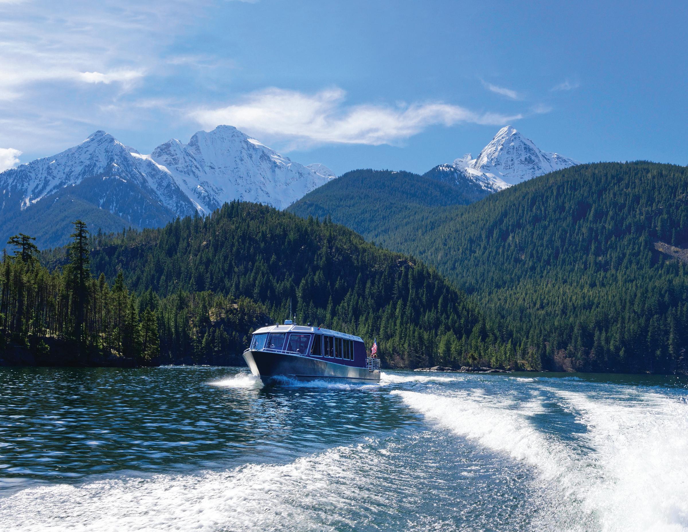
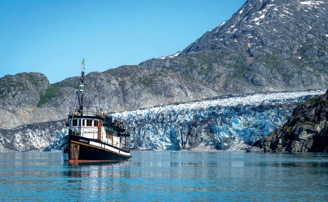
Story & Photos by Christine Smith
The first words from our very first passenger as she stepped aboard my tour boat, the David B in Juneau, Alaska, were, “I don’t know why you would want to do this; the general public is atrocious!”
I laughed nervously, wondering if her remark might prove true. It was early July in the summer of 2006. My husband Jeffrey and I were already on edge, standing on the cusp of something thrilling and uncertain: the beginning of our journey into entrepreneurship and the wilderness of southeast Alaska.
When we cast off the lines and began our first trip, we embarked not just on a voyage through Alaska’s wilderness but into the heart of something much larger. Now, 20 years later, I look back on that moment with profound gratitude. This landscape—rugged, wild, and humbling—has become an inseparable part of me, offering richness I could never have imagined, and immersing the people we’ve traveled with in the wilderness has made them anything but atrocious.
Alaska, water connects everything. The tidewater glaciers bring minerals and nutrients from immense ice fields, linking the mountain realm to saltwater. Much like a spawning salmon returning to its natal stream, this connection bridges ocean and forest, creating an unparalleled wealth of biomass.
Over the twenty years I’ve spent in Alaska, one of my favorite places has become a small, unassuming point of land at the mouth of Endicott Arm in the Tracy Arm/Fords Terror Wilderness named Wood Spit. Thousands of cruise ship passengers pass it by without a second glance. The large ships glide past Wood Spit on their tightly scheduled route to the glacier. I wonder how often their passengers catch glimpses of humpback whales or see the occasional bear along the shoreline. Do they ever even notice the David B anchored nearby or see us exploring ashore—or if, for them, the wilderness is merely a beautiful but fleeting backdrop on their way to the next port?

The vastness of southeast Alaska’s Tongass National Forest, where we operate, is more than “just a rainforest.” Ancient conifers in dark emerald hues and luminous goldengreen mosses teem with life. Glacier Bay National Park, where we also explore, is far more than “just a playground.” Its rugged mountain peaks rise and disappear into ocean-heavy clouds, and its land, newly freed from glacial ice, is ecologically and physically rebounding. The water in these places presents itself in surreal shades of turquoise, a vivid reminder of the icefields feeding them.
In Alaska, especially southeast
Most days when we are underway, I reflect on water in all its forms—rain, ice, mist—and how it sculpts the landscape. Fog and clouds often transform the surrounding wilderness into something ephemeral and mystical. I’ve come to really love the rain, though it took patience to get there, and while many guests hope for clear skies during their week aboard, the rain reveals the area’s true beauty. It brings waterfalls to life and releases the earthy scents of the forest with notes of watermelon mingled with the deep, humic aroma. That scent, faint yet primal, stirs something deep in me and draws me to the shore and into the forest.
Wood Spit isn’t striking at first glance. It’s what is known as a terminal moraine, a mound of debris left by glaciers during the last ice age. Once, a millennia ago, Dawes Glacier’s towering ice wall loomed here; now, the glacier’s face sits some 27 miles deeper in a fjord of its own making. Where the ice once dominated, Wood Spit blends seamlessly into the old-growth landscape. For me, it is a vital place of connection.
Each time I step out of the skiff and stand at the water’s edge, I am reminded of my relationship with this place. The round rocks and large angular “erratic” rocks left by the glacier are now home to barnacles, snails, limpets, chitons, and others. When I look up at the line of trees, I imagine ancient Dawes in place of the towering spruce and hemlock trees. It’s difficult for me to grasp the long shadow of geologic time, but occasionally an iceberg that has made its way from the face of the modern Dawes Glacier comes to rest on the beach–a silent ghostly reminder of
the glacier’s more robust past.
From the water, the forest at Wood Spit looks impenetrable, a low, tangled barrier of devil’s club, salmonberries, and alder that appears to bar anyone seeking to enter. When I bring people here, it’s not for an iconic view of Alaska found on postcards or social media. The forest itself is the destination.
As we approach the forest, I like to take my time. I want to give any unseen animals behind the tangle barrier a chance to observe our presence and avoid us. Here is where the conversation often turns to bears. In my twenty years of coming to this place, I’ve noted that this beach is home to bears, predominantly black bears, and I have occasionally watched wolves, moose, porcupines, and even rough-skinned newts. With this familiarity, I find myself asking permission to enter. It’s a habit born of respect for the interconnected lives that make up this forest–plants, animals, and fungi, all thriving together. Abruptly forcing my way in feels intrusive and impolite.
Over time, I’ve guided lots of people into this forest community, from greatgreat-grandmothers to young children.
Many have never experienced an ancient forest, and I love watching their faces as they step into this world for the first time. I’m warmed to hear that familiar gasp as they recognize the synergistic magic of an old forest.

Beyond the dense edge, the forest opens into a cathedral-like space. Towering Sitka spruce and hemlock stand their ancient watches, their massive trunks spaced respectfully apart.

Fallen trees, blanketed in moss, have become nurse logs, nurturing a new generation of seedlings, tiny shadeloving wildflowers, and fungi. These decaying giants are the essence of the circular nature of life and death in the forest. Everywhere, piles of nibbled spruce cones signal the underground networks of red squirrels.
I’ve come to know this bit of forest well. Once inside, it’s hard not to notice the game trail that runs along the inside edge. Trails like this form a crisscross network of what I like to describe as a bear highway system. I’ve walked this trail a hundred or more times, yet it’s always interesting and is always different. Along the way, we discuss everything from bears to banana slugs. I often pause to share my appreciation for how this scene plays out over and over in southeast Alaska. Yes, the forest looks like a uniform landscape from the water’s edge, but behind the tangled edge, it’s different. Some time ago, a bear left its claw marks on a tree; I call this spot The Crossroads. At this intersection, the trail turns deeper into the woods or continues to a clearing a short distance away, filled with ferns, fireweed, and wildflowers.


One of my most cherished practices happens at the crossroads. Here, I ask my guests to stop and sit down. We sit in silence. At first, people fidget and squirm, unsure of what to do with themselves. We all feel awkward, but as the minutes pass, they begin to soften. Some close their eyes, while others lie down or stare at the canopy. Sometimes, people softly touch the moss as if petting a beloved cat or dog. On rainy days, the canopy muffles the raindrops’ descent, creating a sense of being misted. As we sit longer, birds begin to call, squirrels return to their chatter, and on rare occasions, we’ve heard the wingbeats of ravens and bald eagles cutting through the stillness.
I started this practice years ago during a time when I felt disconnected from nature. Sitting in silence, surrounded by the forest, helped me find my place within it. It’s a deeply grounding experience, a reminder that we are not separate from nature but part of it.
Our word for “nature” comes from the Latin natura, meaning “birth” or “the process of being born.” Sitting beneath the trees on this mossy carpet, free from push notifications and leaf blowers, I feel as though I am being born back into nature.
Glaciers hold a particular fascination for me. They are among nature’s most powerful forces, shaping the landscape in
dramatic, nearly incomprehensible ways. Their true power lies hidden, veiled by the vast time scales in which they work. Standing before these spellbinding blue walls induces a kind of humility that only nature can provide. Glaciers command respect.
Tidewater glaciers calve ice from their towering faces in breathtaking displays. Some of the glaciers we visit rise 200 to 300 feet high from the waterline, with more below the water. When they

“It
By Jeffrey Smith
In the unimaginable time before the internet, going into the wilderness meant researching using books and magazines. It meant pouring over topo sheets and nautical charts. If you were lucky, there might be photos and stories from others to inspire you. If you were really lucky, there might be beautiful prose describing the place you wanted to explore, such as the wonderful romantic writings of John Muir, the grandfather of travel and adventure writing about the wilderness.

Where the government publication blandly but factually states, “Dawes Glacier, at the head of the arm, extends to the water’s edge,” Muir enthusiastically penned, “It shows grandly from where it broke on our sight, sweeping boldly forward and downward in its majestic channel, swaying from side to side in graceful lines around stern unflinching rock.” It pulls at your emotions. Muir was inspired by these places, and his words inspired those who read his descriptions. The outdoor world was something to be experienced and valued, an idea contrary to the mentality of his day. Others explored those places he wrote about, and they began to care for them. His writings formed the beginning of the conservation movement, but they are also the original travel guide.
I’ve spent the last 20 summers following Muir as he explored by native canoe. He visited Alaska seven times, documenting what he found in the romantic language of his day, inspiring others to seek out the same beauty and solitude for themselves. I take people to those same places on the tour boat I run, and to give them context for what we’re seeing, I read aloud to them from his Travels in Alaska, published in 1915. We drift quietly through Fords Terror, sometimes the only boat for miles, as I read his description:
“Gliding on and on, the scenery seemed at every turn to become more lavishly fruitful in forms as well as more sublime in dimensions—snowy falls booming in splendid dress; colossal domes and battlements and sculptured arches of a fine neutral-gray tint, their bases laved by blue fjord water; green ferny dells; bits of flowerbloom on ledges; fringes of willow and birch; and glaciers above all.”
It’s very emotional stuff, hard to resist. You must go there, and his eloquent words can be your guide.
calve, the ice might crumble like a collapsing wall, or immense pillars of it might sheer off, thundering into the water below. The sound is not only heard but is felt like a blast that reverberates through your entire being. The waves born of these calvings roll outward, coming high and sharp, then smoothing into long, low swells that bounce between the steep fjord walls. We go to these glaciers to witness them, to be awed by the immense power they hold.
A few years ago—though I can’t recall exactly when or whose story this was—we were on our way to one of the many tidewater glaciers we visit. A passenger recounted a visit to another glacier on a different boat. She told me how the captain had stopped at the glacier’s face, blasted the ship’s horn, and encouraged everyone aboard to shout obscenities at the ice in hopes of triggering calving. Unimaginably disrespectful.
The relationship I’ve developed with these glaciers couldn’t be more different. Visiting them is an act of care and reverence. There’s a delicate skill in navigating the labyrinth of floating ice and in holding the boat steady amidst swirling currents laden with icebergs. I’ve come to know the glaciers and their distinct “personalities.” Some display vibrant blue ice, while others are lighter and layered with rubble. Some calve often, others rarely. Some feel approachable, while others possess an undercurrent of danger.
I approach each glacier with respect, much like when I enter

Celebrating 40 years!
the forest; I often ask permission to visit. They are ancient forces of nature, deserving of awe and reverence.
Reflecting on my time in Alaska and what it taught me, I find it nearly impossible to pinpoint one place or experience that encapsulates it all. Instead, it’s an accumulation of places and moments that have shaped not only how I present myself to nature but also what I seek from it in return. Heart-stopping beauty—calving glaciers, bubble-net feeding humpback whales, courting brown bears, and auroras dancing across the sky fill Southeast Alaska. Still, places like Wood Spit, with its quiet forest trails and unassuming beauty, hold the deepest meaning for me.
That first guest aboard the David B asked, “Why would you do this? The general public is atrocious.” Twenty years later, I have my answer. People aren’t inherently atrocious— they are simply deprived of nature. Something as simple as watching a glacier or sitting still in a forest, letting the quiet beauty of the natural world seep into the soul, can heal that deprivation.
Through guiding I’ve come to understand the profound importance of connection. Connections to nature, to each other, and to ourselves, and for that, I am endlessly grateful.


by Paul Tolme
Washington has been named the most bike-friendly state by the League of American Bicyclists, a national nonprofit that advocates for safer bicycling conditions. Washington won the top spot thanks to one of the most exciting and hopeful bicycling initiatives in the United States.
Called the Statewide School-Based Bicycle Safety Education Program, it brings bicycles and bike education to public schools and after-school youth programs statewide. The goal is to teach our youth the essential life skills of bicycling for transportation, health, and fun.
Elementary and middle schoolers will get the ‘Let’s Go Bike’ education in physical education classes. High schoolers can join after-school bike clubs and bicycling programs. Funded through Washington’s Climate Commitment Act, the program is in its second year and is currently found in more than 150 schools statewide.
Programming will expand yearly to include more schools, students, and communities–with a goal of reaching 90 percent of our youth.
If you are a parent or a teacher, I encourage you to learn about this amazing programming that Cascade Bicycle Club is implementing in partnership with the Washington State Department of Transportation, local school districts and educational service districts, and community nonprofits that work with youth from underserved communities.
The League of American Bicyclists says Washington’s program is a model for other states, and it lauded the bike program in its 50-state rankings. The League also gave Washington high marks for its investments in bike infrastructure and our laws and policies in support of bicycling.
Hopefully, by teaching our children how to bike, more adults will also rediscover the simple joy of biking to work or nearby destinations. Now is your chance. May is National Bike Month.
If you are curious about bike commuting, electric bikes, or bike lessons and free group rides, Cascade Bicycle Club and other bike groups across the region are holding events throughout the month—the fun peaks on May 16, Bike Everywhere Day.
On that day, Seattle and many communities will have Celebration Stations where people who bike can get free coffee, pastries, and goodies. Go to Cascade.org to find a Celebration Station near you.


Brandon Nelson
COMPASS | Real Estate Agent (360) 319-0696
Brandon@BrandonNelson.com


Story and Photo by Dana Snyder
Onthe last day of my visit to the Bisti/ De-Na-Zin Wilderness in Northwestern New Mexico, I set out in the hopes of capturing astrophotography images of the formation known as the Alien Throne, located in the aptly named Valley of Dreams.
The trail wasn’t long or difficult….but required returning through this labyrinthian landscape in total darkness. Luckily, the group I was with had a wonderful Navajo guide, who was full of information, Navajo words, and histories, so I could just enjoy following and listening. After about an hour of hiking, we found ourselves surrounded by amazing hoodoos and bizarre formations, a dizzying display of what the wind and rain can do over the eons.
They silently populated the land, like a gathering of survivors, no doubt with stories of their own. It felt like a visit to a museum, sacred and profound. My visit was too short, and a return just might be necessary.
ANW
Image © Dana Snyder


Our mission is to provide exceptional dental care in a modern and caring environment. Proudly serving Whatcom County since 1995.
We welcome our newest team member, Dr. Duckles, who joined us in October.
Please call 360-676-1138 to schedule an appointment.
We look forward to meeting you!
3031 Orleans St #201, Bellingham

I love my North Face Women’s Summit Series Breithorn Hoodie! It arrived just in time for our winter’s coldest few weeks. I stayed toasty and warm, even without extra layers underneath, thanks to the 800-fill ProDown™ with water repellency (Responsible Down Standard). One of the other features that I appreciate is the slightly longer back (27 in.), which covers my bottom. The outer layer is 100% recycled nylon ripstop with non-PFC durable water-repellent. The jacket is super lightweight (13.47 oz.). Because it is a Slim fit, I ordered a size up and am glad I did so I can wear multiple layers underneath. More info: www.thenorthface.com

If you’re serious about staying dry in the worst that the mountains of the Pacific Northwest can throw at you, look no further than the venerable Arc’teryx Beta AR Men’s Jacket, a hardshell you can depend on. The Beta AR has been a mainstay at Arc’teryx for going on 20 years, and for good reason: the Gore-Tex Pro membrane provides extraordinary protection from the elements, and—like everything Arc’teryx makes—they built this shell to last for years and years.
More info: www.arcteryx.com

by Chris Gerston

always been impressed with any technical garment from Rab and the Evolute Hoody is no exception; it’s an amazing layering piece. Under my ski shell, it manages a comfortable microclimate as few other pieces can. In many ways, this mid-layer reminds me of the Patagonia Nano Air and others of that ilk, but without a wind-resistant shell or an inner liner, so the insulation is lighter, exposed, breaths better–and is $65 less expensive.
This hoody is made for high aerobic activities in changing temperatures throughout the day. Specifically made to work under a shell, the Evolute Hoody retains warmth in the long-haired fleece and disperses moisture to the stretchy shell as your activity starts and stops. The hood fits perfectly under a helmet and the elasticized fringe keeps it out of your face. This active insulation allows you to dump extra heat when needed, yet also keeps you warm.
Although the Evolute Hoody is less able to shed a biting wind, it’s the perfect choice if you are overheating in other mid-layers.

FIND Adventures Northwest is available free at hundreds of locations region-wide: throughout Whatcom, Skagit, San Juan, and Island counties, at select spots in Snohomish, King, and Pierce counties, and in Leavenworth, the Methow Valley, Spokane, and Wenatchee. The magazine is also available at REI locations across Washington and Oregon as well as at numerous locations in the Vancouver, BC metro area, at races and events, and area visitor centers.
SUBSCRIBE Receive Adventures Northwest via mail anywhere in the US or Canada. Visit AdventuresNW.com/subscribe for subscription info.
ADVERTISE Let Adventures Northwest magazine help you reach a diverse, receptive audience throughout the Pacific Northwest, and be part of one of the most valued and

Backcountry Essentials, owned by Chris Gerston, is an outdoor specialty shop located at 1417 N. State St. in Bellingham, WA.
Check out more of Chris’ gear reviews at AdventuresNW.com

engaging publications in the region. Info is at AdventuresNW.com/advertise or by writing to ads @ AdventuresNW.com.
CONTRIBUTE Adventures Northwest welcomes original article queries—including feature stories, expert advice, photo essays, the Next Adventure shot, etc. For information: AdventuresNW.com/contribute.
EVENTS Have your outdoor-related event, race or public outing listed in our comprehensive online events calendar. Visit AdventuresNW.com/submit-your-event to post events or contact ads @ AdventuresNW.com for details


Located in Southern Washington near the mouth of the Columbia River, Cape Disappointment is one of my favorite places to visit during the winter storm surf season. On this day, I arrived very early to ensure I beat the crowds of photographers who had made the Cape a pilgrimage site. My reward was solitude, witnessing a spectacular sunrise accompanied by the crashing of the incoming waves. As always, Cape Disappointment did not disappoint!


Escape to Skagit Valley, where adventure and relaxation blend seamlessly. Wander through charming small towns, unwind on serene beaches, and explore lush forests that invite you to roam. Springtime, we invite you to tiptoe through the tulips as vibrant fields burst into color, creating a picture-perfect backdrop for your getaway. Whether you're here for outdoor exploration or a peaceful retreat, Skagit Valley is where unforgettable memories begin.
www.visitskagitvalley.com Discover Magic Skagit the of


