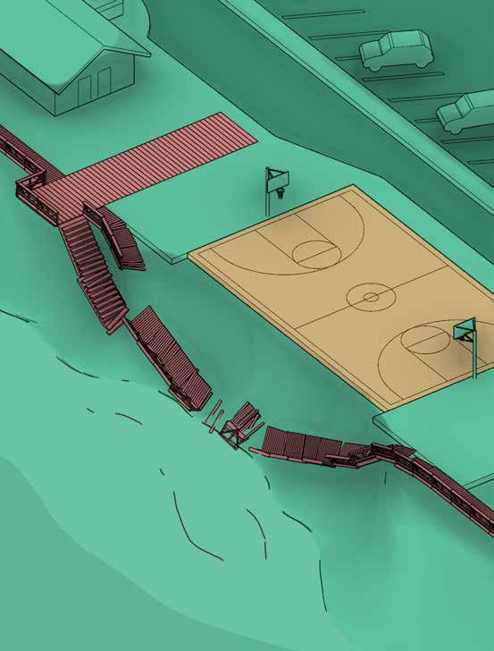


Dana Point
In 2023 and 2024, as part of a beach replenishment project, bulldozers spread sixty thousand cubic yards of sand from the Santa Ana River in Capistrano Beach. “Capo Beach,” as it is known to locals, is at the southern end of Dana Point, about halfway between Laguna Beach and San Clemente, towns defined by their relationship to the Pacific Ocean. The slim strip of sand abuts a boardwalk, the tracks of Amtrak’s Pacific Surfliner, the Pacific Coast Highway, and residential development on adjacent bluffs. Both the beach and these adjacent features are under threat from sea level rise, which is especially evident during seasonal storm surges.22 Though sand levels rose and fell naturally in previous decades, ever since the 2015 El Niño, the beach has narrowed dramatically.23 Storms have exposed protective measures from the past, including the fossils of old cars that were once part of a historic seawall. Other effects of erosion by tidal action have included disruptions to Amtrak, which is often out of service due to its tracks being covered with debris.24 An active debate has developed over whether the tracks should be further protected from erosion or moved inland.25 Measures such as adding riprap (large stones) and geotextiles have been tried over the years, but these have not been effective at preventing erosion. Organizations like the Surfrider Foundation have encouraged the California Coastal Commission to come up with a long-term solution to change the nature of the beach while preserving its public nature.26 In a case like Capistrano Beach, where sand replenishment can be undone in a single storm, can we imagine more sustainable modes of beach revitalization?27 The possibility exists, though it would involve removing concretized riverbeds, for example, which would allow such processes to happen naturally.
drawing by Langston Hay
Pacifica
As sea levels rise, houses precariously perched on the coast seem increasingly like disasters waiting to happen. Why aren’t more of them deconstructed in advance of their inevitable demise? In 1939, Jean and Joseph Fassler purchased a single-room shack on the picturesque coastline of Pacifica, today a small city located between San Francisco and Half Moon Bay. The house was so close to the water, you could cast a line from its deck at high tide. Its beachfront view was shared with just a couple of other dwellings. Over the years, on weekends, Joseph expanded the house until it ultimately became a three-bedroom, two-bath residence with a two-car garage. As the Fasslers raised their family there, the house became a local landmark due to Jean’s political career. When Pacifica incorporated in 1957, Jean became its first mayor, later serving on the San Mateo County Board of Supervisors, and she was also appointed to the Citizens’ Advisory Committee on Recreation and Natural Beauty by the Johnson and Nixon administrations. Years after the Fasslers moved out, the home fell into disrepair under new owners.50 The property, on one and one-third acres of land, was eventually purchased by the city, and the house was demolished as part of a “planned retreat”—that is, an organized effort to move structures out of harm’s way in the face of climate dangers (in this case, rising sea levels).51 Television crews watched as the house was torn down in minutes.52 But why did the city remove the house in the first place? The removal was part of a larger restoration initiative that included widening the mouth of San Pedro Creek and providing spawning habitat for steelhead trout— changes that will ultimately help preserve the beach in ways the house itself hindered. While climate change was not a known issue when the house was built, its demolition raises a question: How do we decide what to maintain and what to tear down as sea levels rise?
drawing by Bhavi Patel
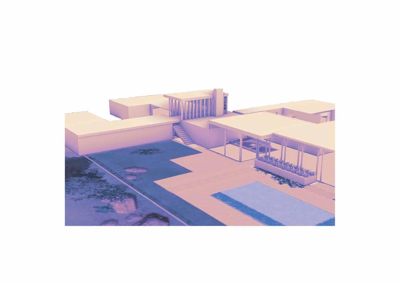

Palm Springs
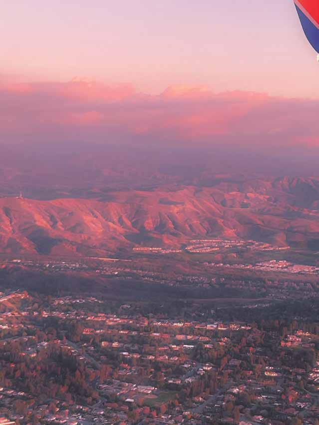
The Kaufmann Desert House is an icon of modern architecture designed by Richard Neutra and built in 1946 (the name Kaufmann is familiar to many architects as the client who commissioned Frank Lloyd Wright’s Fallingwater).79 The Kaufmann house set off an architectural trend that has made Palm Springs a destination for design enthusiasts.80 The house is a dynamic composition of rectangular planes made of concrete, stone, and glass that erupt from the rocky landscape. It was designed in response to the arid environment, with shaded breezeways strategically located to keep the house cool during the day and stone areas that emit heat during the cool nights. But the desert environment is transforming due to climate change, and passive techniques are no match for rising temperatures. Though the house originally included radiant heating and cooling, rooftop air-conditioning units were added as discreetly as possible in the 1960s.81 In 2024, Palm Springs experienced eighty-three days above 110 degrees Fahrenheit (compared to twenty days in 1946). The number of extreme heat days (defined as above 115 degrees) in Palm Springs is predicted to increase to twenty-eight by mid-century and to fifty by the end of the century.82 In July 2024, a new heat record was set: 124 degrees Fahrenheit.83 Places like Palm Springs are at the forefront of climate change and an ideal testing ground for extreme heat. Residents are acutely aware of heat-related phenomena. Speaking with The New York Times about living in Palm Springs, resident Maggie Miles said, “My debit card melted in my drink holder. I’ve seen the internal car temperature get up to 150 degrees.”84 Could the Kaufmann House, once an icon of pleasant indoor-outdoor living and harmony between humans and nature, become a symbol of our shift toward a more discordant relationship with an increasingly inhospitable environment?
drawing and
AR
by Tabitha Saunders and Liang Qiao

San Francisco
What is the most notorious building in San Francisco today? It does not have a particularly identifiable silhouette, and it has the somewhat generic glass-centric aesthetic of many urban towers of the early 2000s. The building is the Millennium Tower, a fifty-eight story, 645-foot-tall condominium. As of 2022, the skyscraper had sunk eighteen inches and tilted twenty-four inches to the west.118 While the tilt has been stopped through various engineering fixes, the sinking is not unique to the 419unit building, completed in 2009. The larger issue here is that San Francisco itself (as well as several other cities worldwide) is slowly sinking, a phenomenon known as subsidence.119 A recent report by Science Advances notes that subsidence can exceed ten millimeters per year when the ground is a combination of artificial landfill and mud, as is the case in many parts of San Francisco.120 Another contributing factor has been construction at the nearby Transbay Terminal, where up to five million gallons of water have been pumped out of the ground each month in a process known as dewatering, a crucial precursor to construction.121 Moreover, California has gone through years of drought, further compounding the issue. For cities like San Francisco that are at risk from rising sea levels, subsidence is a dual blow.122 And while $100 million was spent fixing the tilt at Millennium Tower—a luxury building enjoyed by wealthy residents—its woes raise a broader issue: how to address the combined problems of sinking land and rising seas, especially when they impact not just buildings but public infrastructure too.123

San Francisco
Mission Bay, as its name suggests, used to be an estuary that combined fresh- and saltwater marshes, tidal mudflats, and a shallow bay. In this state, it was habitat for a variety of waterfowl, including ducks, geese, and herons. Originally home to the Yelamu people, it became a shipbuilding, fishing, and meat production center under European settlement in the 1800s.124 Over the years, however, it turned into a dumping ground for debris and dilapidated ships. The waste ended up filling in Mission Bay, a pattern repeated throughout the region. During the last 150 years, 90 percent of the marshes in the San Francisco Bay have disappeared due to industrialization.125 Once filled in, Mission Bay became home to a variety of commercial uses, including canneries, a sugar refinery, and warehouses. Recent years have brought a surge in development. As of 2024, the area is home to the Chase Center, Uber’s headquarters, and the UC San Francisco Mission Bay campus. One of the lowest-lying areas of the city, Mission Bay is particularly susceptible to sea level rise. A 2016 study by the San Francisco–based think tank SPUR concluded that Mission Bay should proactively consider adaptation measures to counter rising sea levels.126 Unlike New York, which suffered severe damage during Hurricane Sandy in October 2012, Mission Bay still has time to develop a plan before any major disaster occurs.127 Some measures under consideration include upgrading buildings to be able to withstand flooding and raising the most flood-prone land. Perhaps Mission Bay’s status as one of the lowest-lying and fastest-growing neighborhoods could be an opportunity? The area could be a testing ground for a range of experimental adaptation strategies that could then be evaluated and replicated throughout San Francisco and beyond.
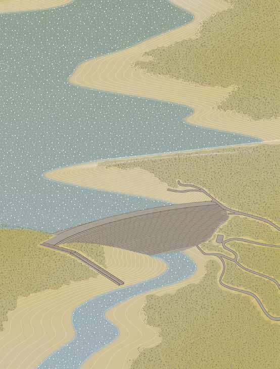
At 770 feet high, the Oroville Dam was once considered the ninth wonder of the world; it is still the tallest dam in the United States.138 Holding back the state’s second-largest reservoir, Lake Oroville, it supplies water to 750,000 acres of farmland and twenty-seven million residents (about 70 percent of California’s population).139 The dam can provide 645 megawatts of power, about enough to power eight hundred thousand homes. But on August 5, 2021, the lake’s Edward Hyatt Power Plant was turned off due to low lake levels caused by the state’s historic drought. The hydroelectric plant resumed operations five months later, on January 4, 2022, following sufficient rainfall to refill the lake to normal levels.140 The dam illustrates competing forces: On the one hand, dams provide a significant portion of California’s renewable energy (from 7 percent in dry years to 20 percent in wet years).141 On the other hand, dams can have outsize impacts on watersheds stressed by the droughts and deluges that are becoming more intense due to climate change. In 2017, for instance, the dam was compromised after heavy winter rains, resulting in the evacuation of 180,000 residents. Speaking with Grist magazine, Sean Turner, a hydrologist and water resources engineer, referred to potential drought related disruptions: “The impact is less likely to be power cuts and lights out, it’s more likely to be increased electricity costs and potentially increased carbon emissions, because there’s likely to be more reliance on gas and other resources.”142 How can we build and maintain a diverse portfolio of green energy options without causing more harm than good?
drawing with contributions by Stella Isaccs
Beach
Could dormitories offer a sustainable model for communal living? While California laws have changed in recent years to allow increased residential density on single-family lots, dormitories fundamentally challenge assumptions about the provision of private versus shared amenities.149 In contrast to apartments and condominiums, dormitories have a smaller ratio of private rooms to common areas. In 2021, California State University, Long Beach completed its first student housing project in thirty-four years, and it includes many examples of sustainable design. The residence hall, Parkside North, has 472 beds, pod study rooms, shared kitchens, and community areas, squeezing all of this into ninety thousand square feet, or about 191 square feet per bed. 150 Similar resources designed into single-family homes would take double or triple the square footage and require greater land usage. At the same time, Parkside North offers all of these facilities while achieving net zero energy and water usage.151 The project was recognized both by LEED and the Living Building Challenge.152 While LEED is a fairly wellknown system intended to lower a building’s carbon footprint, the Living Building Challenge goes even further, advocating for buildings that contribute positively to the environment.153 As the state shifts away from low density single-family zoning, examples such as Parkside North look beyond what single-family structures typically provide to suggest more communal ways of living—ones that could make a serious impact on cutting greenhouse gas emissions. How might dormitories, traditionally a form of dwelling associated with students, be looked at again as a model for a broader swath of people? Could this type of housing work both in commercial districts and single-family zones?
drawing by Bhavi Patel
San Francisco
Now a bustling destination for commuters, foodies, and tourists, the San Francisco Ferry Building, which originally opened in 1898, was once the primary gateway to the city for those arriving by a combination of transcontinental train and regional ferry.167 It was designed in the Beaux-Arts style by architect Arthur Page Brown (who sadly did not live to see its completion) and includes a 660-foot-long skylit nave and a 245-foot-tall clock tower inspired by Spain’s Seville Cathedral.168 When it was built, skeptics worried it might fail during an earthquake or that its concrete foundation would sink into the bay. But it immediately became a San Francisco icon, gracing postcards and appearing in films like The Maltese Falcon.169 When ferry transit peaked in the 1930s, some 50–60 million people crossed the bay annually on more than fifty ferry services, contributing to about 250,000 passengers flowing through the Ferry Building each day. Built prior to the Golden Gate and San Francisco-Oakland Bay Bridges, it remained largely unscathed by the 1906 earthquake that destroyed much of the city.170 In 2006, the Embarcadero historic district was nominated to the National Register of Historic Places.171 But in 2016, the Ferry Building was deemed one of the eleven most-endangered historic places in the United States due to seismic threats and sea level rise.172 The area where the building sits is particularly vulnerable because the ground beneath it is no more than bay mud (with bedrock as far as 240 feet below).173 The Port of San Francisco and the Army Corps of Engineers are considering raising the surrounding area by as much as seven feet to reduce flood risk, at a predicted cost of $13.5 billion.174 While the area was constructed before residents knew of sea level rise, it raises questions about what gets protected and at what cost. Furthermore, as many cities convert industrial waterfronts, how might public infrastructure protect cities rather than become liabilities that need protection?
drawing and
AR
by Maggie Ma and Aileen Louie
Stockton
As housing prices have soared in major metropolitan areas like San Francisco, people are forced to live farther from the places that are often a source of high-paying jobs. This displacement has given rise to what has become known as the “super commuter”—that is, someone with a commute time of ninety minutes or more. One city that exemplifies this trend is Stockton, where 10 percent of the workforce are super commuters.193 In 2024, the median home price in San Francisco was about triple that of Stockton.194 The phenomenon of super commuting is often interpreted as signaling a fundamental misalignment of jobs and affordable housing, with less attention given to the environmental impact of this misalignment. In fact, transportation accounts for almost one-third of greenhouse gas emissions in the United States.195 Seen this way, ensuring the proximity of jobs to affordable housing is a climate issue. But how do we change this situation? One way is to offer more public transportation options to the periphery; the other is to create more affordable housing in close proximity to urban centers.196 Though housing advocates and the state have worked to create more housing and lower costs (via legislative action such as the California HOME Act, SB 9, for example), more needs to be done.197 How can we reflect on the successes (and failures) of recent measures to make urban centers more affordable? For architects, this could mean a variety of solutions: from repurposing underused offices for housing, to splitting properties, to developing new prefabricated housing.198 What are the implications if we think of housing affordability as a climate issue?
drawing and AR by Adam Overmeer and Langston Hay
Orick
Often, land acknowledgments (paying tribute to Indigenous lands at the beginning of an event) are words without tangible actions. This is a different story. In Humboldt County, long-standing efforts to reclaim land are bringing about necessary environmental healing. Prior to the Gold Rush, the Yurok people were stewards of five hundred thousand acres, including ’O Rew on Prairie Creek.233 Many of the Yurok practices of land management were and still are models of sustainability.234 These include supporting the function of rivers and floodplains, maintaining habitat for wildlife such as salmon and beavers, and implementing prescribed burns that rejuvenate the forest.235 During the nineteenth-century gold rush, extraction started to destroy the ecological function of these lands, as well as the culture and health of the Yurok people. Excessive logging made the forest floor susceptible to erosion, leaving a legacy of fine sediment in riverbeds and clogging gravel areas where salmon spawn. The growth of industrial-scale canneries led to overfishing, diminishing the salmon population.236 In recent decades, Native American tribes, including the Yuroks, have implemented measures to rejuvenate their ancestral lands that will have wide-ranging effects. In 2011, the tribe obtained loans to purchase land with the idea that revenue from sustainable logging could then be used to repay the debt. Two years later, the tribe used California’s Compliance Offset Program to maintain the forest without logging, selling carbon credits to companies in exchange for monitoring the area.237 The return of some of these lands to tribal management is key to a more holistic approach to sustainability. How might projects like this—grounded in the Land Back movement and guided by Indigenous stewardship—transform exploitative and extractive land use practices into a future rooted in restoration and repair?
