

URBAN DESIGN PORTFOLIO

Jinnurain Tasbir Shatil
Selected Academic and Professional Works


CONTENTS
INTEGRATED URBAN MIXED-USE DEVELOPMENT
Postgraduate Urban Design Project / 2022-2023 01
ESRC-funded Research Project / 2023-2024 02
MID-DENSITY COMMUNITY HOUSING MASTERPLAN
Postgraduate Urban Design Project / 2022-2023
Postgraduate Urban Design Project / 2022-2023 04
AN EXPERIENCE OF PUBLIC SPACE IN THE CARDIFF CIVIC CENTRE
UNDERSTANDING SOCIAL INFRASTRUCTURE IN LONDON: LIBRARIES & MARKETS
REHABILITATION OF JUSTICE SHAHABUDDIN
AHMED PARK
Completed Professional Urban Design Project / 2017-2020
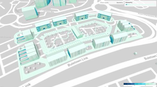
INTEGRATED URBAN MIXED-USE DEVELOPMENT
This is a project of my Urban Design Studio for the ‘Designing Cities’ module in my M.Sc. in International Planning and Urban Design (IPUD) at Cardiff University’s School of Geography and Planning. The module provided an opportunity to synthesise contextual information and theoretical concepts, leading to a comprehensive master plan for a fully integrated urban mixed-use development.
I selected a site within Butetown, Cardiff, analysing its urban quality, key challenges, and opportunities to enhance the area from an urban design perspective. Known as ‘Tiger Bay,’ Butetown has a rich multicultural history shaped by migration during Cardiff’s industrial boom. Its diverse communities have preserved their cultural heritage through festivals, fairs, and public events, often in shared public green or community spaces. Inspired by this tradition, my design emphasises public green spaces as social hubs, fostering inclusivity, cultural identity, and community interaction.
This project documents my design evolution, from site analysis and conceptual framework to the final masterplan, integrating residential, commercial, and community spaces. This project aims to contribute meaningfully to Butetown’s quality of life by critically analysing the existing urban fabric, demonstrating the power of theory-driven, context-sensitive urban design.
BUTETOWN
HISTORICAL TIME-LINE OF BUTETOWN
STARTING OF BUTETOWN COMMUNITY 1911-1930

1930-1963
THRIVING OF BUTETOWN COMMUNITY
1839-1910
THE BUILDING OF THE DOCKS
THE DEATH OF DOCKS 1964-1975
LONG LOST CULTURE OF BUTETOWN
•The site has very good accessibility from the surrounding areas.
•Butetown acts as the connector between City Centre & Cardiff Bay.
•There are no continuous bicycle and pedestrian networks for the dwellers.
•There is no vehicular access from Dumballs Road to Bute Street.
•There are different types of nodes which represents the intersections.
PERMEABILITY
PUBLIC SPACE & URBAN BLOCKS
LANDSCAPE

•There are fairly permeable, very permeable and less permeable areas in the Site which have been divided by Dumballs road and Lloyd George Ave.
•The dead ends have obstructed the permeability in some parts.
•The landmarks are significant and they are different in size, height, use and architectural expressions.
•All the public spaces are within a catchment area of 800 meters or 10 minutes of walking distance from the adjacent neighbourhoods.
•Public spaces are vertically connected.
•Lack of public space networks and horizontal connectivity.
•There are different types of public spaces according to their shape, size and usage.
•Large chunks of green spaces with facilities are serving the adjacent neighbourhoods.
•All the green spaces are in catchment diameter of 800 meters or 10 minutes walking distance from the neighbourhoods.
•Accessible green spaces are inadequate in comparison with open spaces on both sides of Dumballs road.
LAND-USE
BUILDING HEIGHTS
DWELLING AGES
CRIME & SAFETY
•Residential areas dominate, with commercial hubs along key routes. Public sector buildings, education, healthcare, and religious institutions enhance community services.
•Green spaces and vacant lands offer recreation and development potential, while parking and police stations support accessibility and safety.
•This land-use pattern fosters connectivity, mixed-use development, and community well-being.
•Low-rise buildings (≤10m) – Found in residential zones, fostering a pedestrian-friendly environment, enhancing walkability, community interaction, and open spaces.
•Mid-rise structures (10.1m–40m) – Comprise mixed-use and commercial developments, balancing density, connectivity, and functionality.
•High-rise buildings (40.1m and above) – Located near transit nodes and the waterfront, shaping Butetown’s skyline and supporting economic activity.
•Pre-1900 to 1939 – Historic terraced housing from Cardiff’s maritime boom.
•1945–1972 – Post-war social housing and mid-rise developments.
•1973–1999 – Urban renewal with mixed-use and higher-density housing.
•2000–Post-2009 – Modern sustainable developments integrating public spaces.
•High Crime (21-25%): Found in less permeable areas near major roads.
•Moderate Crime (11-20%): Around landmarks and mixed-use zones.
•Low Crime (1-10%): In well-connected, high-visibility areas.
•Barriers (Dumballs Rd, Lloyd George Ave) and dead ends hinder safety.
DESIGN STRATEGIES
CENTRAL GREEN SPACE:

Creating a central open green space to serve the community for different purposes. It will be the interaction hub for the whole community, with good permeability. So that people can come from other parts of the site at any time and make the site more interactive.
GREEN SPACE NETWORK:

Creating a green space alongside the river tuff and some pocket green spaces all over the site to establish a green space network to enhance the recreational facility of the community. These green spaces will also help create a diversified community as people outside will also gather here.
ACCESSIBLE PUBLIC SPACE:

Creating more public spaces that are easily accessible. So that people in and outside the community or different parts of the cities can come to the public areas and enjoy every aspect of urban life in the accessible public space.
PERMEABILITY & LEGIBILITY:

Creating an area with good permeability and legibility. So that people can move easily, quickly and frequently from one point to another while feeling safe. It will eventually help establish an integrated connection with different parts of the city.
SEPARATE ZONING & BUFFERING:

Creating separate zones such as a mixed-used zone, residential zone and community zone and open green spaces between these zones so that they can act as a buffer space.
INTERNAL COMMUNITY SPACE

Creating Internal community spaces those will enhance the social cohesion of the communities. The community can also be benefited from these spaces fostering an incluesiveness.
URBAN FABRIC & BUILT FORM:

Integrating local urban fabric and building forms to enhance familiarity with the community's context.
ACTIVE TRAVEL NETWORK:

Creating continuous and uninterrupted pedestrian and bicycle connections for easy and quick movement to form an active travel network within different parts of the city to reduce dependency on motor vehicles.
DESIGN VISION & CONCEPT
LIVELY COMMUNITY
Designing a Lively Community, that integrates Urban Life, Social Cohesion, Community Interaction, Celebration, and Public Green Spaces into a cohesive framework. This can be achieved through a human-centred, mixed-use development that combines residential, commercial, and recreational spaces with nature and public realms, so that people can enjoy their urban life and celebrate the joy of living fostering a sense of belongingness to the community.
CONCEPT FRAMEWORK

Urban Life : A dynamic mix of residential, commercial, and workspaces to encourage active street life and economic vitality.

Social Cohesion Plazas, community centres, and shared amenities that promote interaction among diverse social groups.

Community Interaction : Well-designed streetscapes, walkable neighbourhoods, and engaging public spaces to foster local engagement.
KEY URBAN DESIGN ELEMENTS
Central Public Space as a focal point for community activities.
Green Corridors & Pocket Parks linking different zones.
Pedestrian and Bicycle-Friendly Streets for sustainable urban mobility.
Mixed-Use Blocks that accommodate living, working, and leisure.
Waterfront Activity with walkways and gathering spaces.
Community Hubs to enhance social networks and shared experiences.


of Life : Cultural spaces, event hubs, and leisure areas that enhance the community’s
Public Green Spaces : Integrated parks, river fronts, and green corridors to promote well-being and sustainability.
CONCEPT SKETCH PROPOSED MASTER PLAN


MASTER PLAN OVERVIEW


CLIMATIC ANALYSIS & SIMULATIONS

The sunlight exposure analysis visualises the solar impact on urban surfaces, highlighting facade, roofs, and other structures based on the duration of sun exposure between 08:00 - 18:00.
Key Insights from the Analysis:
High-exposure zones (yellow areas): These surfaces receive maximum sunlight, indicating potential for solar energy harvesting or shading solutions.
Moderate-exposure facade (orange to brown): Buildings with partial sun exposure, influencing passive heating and cooling strategies.
Low-exposure areas (blue to purple): Indicating shaded or obstructed zones, useful for thermal comfort analysis and urban greenery planning.
SOLAR ENERGY

The solar energy potential analysis evaluates solar exposure on building surfaces, identifying optimal locations for solar panel installations to maximise energy efficiency.
Key Insights from the Analysis:
Total solar energy potential: 68,000,000 kWh annually, with an average solar energy density of 750 kWh/m²
Panel configuration assumptions: 80% surface coverage with 20% panel efficiency.
Estimated energy generation: 86,300,000 kWh annually from 728,257 m² of panel surface.
SOLAR ENERGY

This solar energy potential analysis evaluates the suitability of building surfaces for solar panel installations, optimising renewable energy generation in an urban environment.
Key Insights from the Analysis:
Total solar energy potential: 452,000,000 kWh annually, with an average solar energy density of 1,060 kWh/m²
Selected building surfaces: 427,175 m² filtered between 0-75 degrees
Panel configuration assumptions: 80% surface coverage with 20% panel efficiency.
Estimated energy output: 57,300,000 kWh annually from 347,740 m² of panel placement area.
DAYLIGHT

This daylight potential analysis evaluates the distribution of natural light across building facade and roofs, informing energy efficiency, indoor comfort, and urban design strategies.
Key Insights from the Analysis:
Higher daylight exposure on building facade enhances natural illumination, reducing ar tificial lighting demand. Well-lit facades improve visual comfort and contribute to passive solar heating in colder months.
Strategic massing and orientation optimize sunlight penetration, supporting sustainable urban design and energy-efficient architecture.
WIND COMFORT

This wind comfort analysis evaluates the pedestrian wind environment using the Lawson LDDC comfort scale, categorizing areas based on suitability for different activities like sitting, standing, strolling, and walking.
Key Insights from the Analysis:
Green zones indicate comfortable areas for sitting and standing, ideal for public spaces, plazas, and outdoor seating.
Yellow and orange zones represent moderate wind exposure, suitable for walking and movement corridors.
Red zones highlight areas with high wind discomfort, requiring wind mitigation strategies such as vegetation buffers, canopies, or architectural wind deflectors.
WIND EXPOSURE

This wind exposure analysis visualizes the distribution of wind intensity across the site, helping to assess pedestrian comfort and micro-climatic conditions.
Key Insights from the Analysis:
Blue zones indicate areas of lower wind exposure, suggesting comfortable pedestrian environments for social interaction, outdoor seating, and green spaces
Darker blue shades show regions with slightly higher wind speeds, ideal for natural ventilation but may require wind mitigation measures for enhanced comfort.
Strategic tree placement and urban form adjustments can optimise wind flow, reducing discomfort and promoting a resilient, pedestrian-friendly urban environment.

This microclimate analysis evaluates thermal comfort and environmental conditions across the site, considering air temperature, solar radiation, and humidity
Key Insights from the Analysis:
Predominantly green areas indicate comfortable thermal conditions, ensuring a pleasant outdoor environment with minimal heat stress.
Building rooftops and paved-surfaces show slightly warmer conditions due to solar exposure, suggesting opportunities for green roofs, reflective surfaces, or shading strategies.
Vegetation zones and tree-lined streets contribute to cooler microclimates, enhancing walkability and public space usability.
NOISE POLLUTION MICROCLIMATE

This noise pollution map assesses sound levels across the urban environment, highlighting key areas affected by noise.
Key Insights from the Analysis:
High-noise zones (red areas) align with major roads and active urban corridors, indicating significant traffic and human activity.
Moderate noise levels (yellow zones) extend into surrounding areas, suggesting secondary exposure to urban sounds.
Low-noise zones (green areas) dominate residential and green spaces, ensuring a quieter environment suitable for relaxation and well-being.
DESIGN CODES
STREET TYPES
PARKING ARRANGEMENTS
VERTICAL MIXED-USE
BUILDING DEPTH


VISUALISATIONS

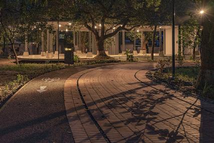
The Central Green Space designed for community engagement, sustainability, and active urban life. Featuring greenery, play areas, pedestrian paths, and shaded seating, it enhances walkability and social interaction while integrating seamlessly with surrounding residential and commercial zones. With green infrastructure supporting climate adaptation and biodiversity, this space serves as a resilient, inclusive, and people-centric urban hub.

The River-side Green Space illustrates a vibrant, nature-integrated public realm that enhances urban resilience and community well-being. Featuring lush greenery, meandering pathways, and waterfront access, it promotes biodiversity, recreation, and active mobility.
The Community Hub and Street showcases a vibrant, pedestrian-friendly space designed for social interaction and urban connectivity. Featuring green pockets, shaded seating, and active frontages, it enhances walkability and community engagement. Landscaped buffers and shared streets promote safe, inclusive mobility, creating a dynamic and people-centric public realm.


The Connectivity with Residential Zone visualization showcases seamless integration of public spaces and urban living, enhancing walkability, accessibility, and community interaction through pedestrian-friendly streets, green buffers, and safe crossings.
The Connection with Vale College visualization highlights a welcoming, pedestrian-friendly gateway, enhancing accessibility and interaction between the college and public spaces. Featuring green corridors, seating areas, and active pathways, it fosters engagement, safety, and a seamless urban connection.
Central Green Space
Community Hub and Street
River-side Green Space
Connection with Vale College
Connectivity with Residential Zone

MID-DENSITY COMMUNITY HOUSING MASTERPLAN
This is an academic project of my Urban Design Studio for the ‘Site Planning, Design and Development’ module in my M.Sc. in International Planning and Urban Design (IPUD) at Cardiff University’s School of Geography and Planning.
The aim of this project is to design a mid-density community housing masterplan for Butetown/Cardiff Bay, emphasising spatial awareness and design clarity. The core concept centres on generous green spaces, both central and pocket-sized, for landscaping and social interaction. A main vehicular entry (5500 mm) and two exits (4800 mm), along with 4100 mm-wide internal roads, enable smooth traffic flow, while a pedestrian network (1800–2400 mm) and multiple access points ensure walkability. Each unit includes a dedicated 2400×4800 mm parking space, and the homes are oriented for maximum sunlight and north-south ventilation. A central community space links the two primary green areas, enhancing social cohesion and outdoor amenities.
Predominantly residential, with apartment blocks along Lloyd George Ave and clustered in the northeast and southeast. Parking facilities available for tenants and public users on Schooner Way. Limited green space, with a major cluster behind Lloyd George Ave and a small area in the southeast.
BUILDING FRONTAGE
Residential blocks face green spaces, enhancing comfort. The north is mainly housing, the south is mixed-use, and the east features hotels and dining near Cardiff Bay. County Hall offers open views, but its rear car park lacks engagement. The area is legible and well-connected.
TOWNSCAPE ANALYSIS
and
LEGIBILITY
Predominantly residential, with apartment blocks along Lloyd George Ave and clustered in the northeast and southeast. Parking facilities available for tenants and public users on Schooner Way. Limited green space, with a major cluster behind Lloyd George Ave and a small area in the southeast.


A strong pedestrian network supports connectivity, but dead-end paths and inactive frontages reduce engagement. Key landmarks enhance visual appeal, though gateways and green networks are lacking. Junction points aid interaction, but waterfront access is obstructed in areas. Level changes are effective, yet hard surfaces need improvement. Strengthening community spaces and connectivity is key.


DESIGN PRINCIPLES
HOUSING CLUSTER:

The housing cluster integrates row housing cluster with double- and single-aspect units encloses a central green space, fostering community and sustainability. Double-aspect units enhance ventilation, while single-aspect units activate the streetscape, ensuring a walkable and cohesive environment.
COMMUNITY & POCKET GREEN SPACES:

Community green spaces foster social interaction, well-being, and inclusivity. These spaces are accessible from all sides, ensuring uninterrupted views from all buildings. While pocket green spaces provide small, accessible retreats within urban areas, enhancing social interaction, well-being, and biodiversity, promoting a sense of openness and connection, strengthening community cohesion.
COMMUNITY FACILITIES:

A central community facility acts as a shared hub, seamlessly connecting green spaces on both sides. It enhances accessibility, social interaction, and multi-functionality, serving as a focal point for community engagement, recreation, and essential services.
WALKING & CYCLING:

The design integrates safe, continuous pedestrian and cycling paths, linking residences, parks, and community spaces, enhancing mobility, while promotes active transport, ensuring a sustainable and accessible network.
DESIGN CONCEPT
CONNECTED LIVING
The project envisions a mid-density housing development that integrates a central community space with pocket spaces to foster social interaction, promote active mobility (walking and cycling), and enhance the overall liveability of the neighbourhood. The design prioritizes human-scale urbanism, ensuring accessibility, inclusivity, and environmental sustainability while encouraging a sense of belonging among residents.


Community & Interaction: The essence of social life, where people connect and engage.

Place & Experience: The spatial setting that fosters movement, gathering, and activities.

LIVING

Structure & Identity: The built environment that shapes and defines the character of a place.
CONCEPT SKETCH CONNECTED


• Total Site Area = 01 Hectare / 10000 Sm.
• Total number of dwelling units = 75
•The car parking ratio = 1:1
• Total number of car parking spaces = 75
• The area of formal play spaces = 1,464.849 Sm.
•The area of total green spaces for landscapes = 578.33 Sm.
• Total area of open green spaces = 2,475.179
•The percentage of total open green spaces = 24.75 %
• Total number of affordable units = 36 (A, B, I, H, G, F)
•The percentage of affordable units = 52%
MASTER PLAN OVERVIEW


CLIMATIC ANALYSIS & SIMULATIONS

This sun hours analysis visualises the distribution of solar exposure across the site, helping to assess daylight accessibility and the potential for thermal comfort and energy efficiency.
Key Insights from the Analysis:
High solar exposure (yellow areas): Indicates optimal sunlight availability, benefiting passive solar heating, rooftop solar panel placement, and vibrant outdoor activity zones.
Moderate exposure (orange to purple shades): Represents areas with partial shading, which can support diverse microclimatic conditions, balancing sun and shade for user comfor t.
Shaded zones (darker purple): Suggest limited direct sunlight, requiring design strategies such as light-reflective surfaces, optimized building orientation, and strategic landscape interventions.
SOLAR ENERGY

This solar panel efficiency analysis evaluates the site's potential for harnessing solar energy, identifying optimal surfaces for photovoltaic panel placement.
Key Insights from the Analysis:
High solar exposure (yellow areas on roofs): Ideal for installing solar panels to maximise energy generation.
Moderate exposure (orange surfaces on facades and pathways): Suitable for passive solar design strategies and integrated PV solutions.
Annual Solar Energy Potential Estimated at 435,000,000 kWh supporting significant renewable energy contributions.
Optimised Solar Panel Configuration: With 80% surface coverage and 20% efficiency, the projected electrical output is 55,000,000 kWh annually.
SOLAR ENERGY

This solar energy assessment evaluates the site's potential for harnessing renewable energy, highlighting surfaces suitable for photovoltaic (PV) panel installation.
Key Insights from the Analysis:
Total Solar Energy Potential: Estimated at 549,000,000 kWh annually, reflecting the site's strong solar exposure.
Optimised Panel Placement: With 80% surface coverage, the projected annual electrical output is 69,300,000 kWh.
High Solar Gain Areas: The rooftops and pedestrian pathways (marked in bright yellow) receive the most sunlight, making them ideal for solar installations.
Moderate Exposure Zones: Some facades and angled surfaces (shaded in orange) could integrate passive solar strategies or secondary PV solutions.
DAYLIGHT
This analysis evaluates daylight availability across the proposed development, helping to optimise natural lighting, energy efficiency, and occupant well-being.
Key Insights from the Analysis:
High Daylight Exposure: Rooftops and upper facades receive maximum daylight, supporting passive solar design and potential for green roofs or solar panels.
Moderate Daylight Zones: Courtyards and mid-rise facades experience consistent daylight, ensuring well-lit residential and communal spaces.
Lower Daylight Areas: Some shaded facades and ground-level spaces have reduced exposure, which may require artificial lighting solutions or reflective surface strategies.
WIND COMFORT

This wind comfort analysis evaluates the pedestrian-level wind conditions across the development, guiding urban design strategies to enhance comfort and usability.
Key Insights from the Analysis:
Comfortable Zones (Green & Yellow): The majority of the site offers pedestrian-friendly conditions, supporting sitting, standing, and strolling activities.
Moderate Wind Exposure (Orange): Certain areas, particularly near building edges and open spaces, experience higher wind speeds, suitable for walking but may require mitigation for prolonged stays.
High Wind Exposure (Red): Rooftops and some open areas face stronger winds, potentially causing discomfort. Design interventions such as windbreaks, vegetation, and urban furniture can help improve conditions.
WIND EXPOSURE

This wind flow simulation assesses wind behaviour across the urban environment, informing climate-sensitive design interventions.
Key Insights from the Analysis:
Wind Pathways (Blue Streamlines): The simulation prevailing wind currents, highlighting areas where wind accelerates through open spaces and around buildings.
High Exposure Areas: Wind is funnelled along major corridors, increasing speeds, which may impact pedestrian comfort. Strategic planting and windbreak structures can mitigate harsh conditions.
Sheltered Zones (Light Blue): Some areas experience lower wind speeds, creating comfortable microclimates ideal for seating, recreation, and social spaces.
MICROCLIMATE

This microclimate analysis evaluates thermal comfort and environmental conditions across the site, considering air temperature, solar radiation, and humidity
Key Insights from the Analysis: Predominantly green areas indicate comfortable thermal conditions, ensuring a pleasant outdoor environment with minimal heat stress.
Building rooftops and paved-surfaces show slightly warmer conditions due to solar exposure, suggesting opportunities for green roofs, reflective surfaces, or shading strategies.
Vegetation zones and tree-lined streets contribute to cooler microclimates, enhancing walkability and public space usability.
NOISE POLLUTION

This noise pollution map assesses sound levels across the urban environment, highlighting key areas affected by noise.
Key Insights from the Analysis:
High Noise Levels (Red & Yellow Zones): The central roadway experiences noise levels exceeding 65 dB(A), making it a high-exposure area that may require mitigation measures such as sound barriers, green buffers, or strategic building orientation.
Moderate Noise Levels (Yellow & Green Zones): The surrounding areas experience noise levels between 55-65 dB(A), which is considered moderate but may still impact residential comfor t.
Low Noise Zones (Green Areas): The inner courtyards and green spaces are in quieter zones (<55 dB(A)), providing a more comfortable and liveable environment for residents and pedestrians.
SECTIONS & VISUALISATIONS


View towards Community Green Spaces

Aerial View
AN EXPERIENCE OF PUBLIC SPACE IN THE CARDIFF CIVIC CENTRE
This Design Project showcases my exploration within the ‘Urban Theory Provocation module’ during my M.Sc. in International Planning and Urban Design (IPUD) at Cardiff University. The project examines the Civic Centre of Cardiff through Ash Amin's theoretical framework of 'The Good City,' which focuses on rights, relations, rejuvenation, and repairs. The goal of this work is to thoughtfully connect theory with practice.
Main objective is to explore how we experience public space in the Cardiff Civic Centre by applying diverse theoretical concepts through creative design practices. The portfolio is structured in three phases, each building upon the previous one to unravel the complexities and possibilities embedded in the urban fabric.
The project unfolds in three phases:
Phase One: Visual documentation of Cardiff Civic Centre, critically examining the tension between idealised urban visions and real-world challenges.
Phase Two: Theoretical analysis and relational mapping, using an assemblage framework to guide design decisions and explore urban interconnectedness.
Phase Three: Urban design interventions, translating site-specific analysis into creative, theory-driven solutions through mapping, site documentation, and visual representation.


Location:
The location of the Cathays Park Campus of Cardiff University is very crucial. Because it is the heart of the university area, surrounded by Bute Park, residential areas at Cathays, university student accommodations, and the City Centre, some of the primary roads, such as North Road and Boulevard De Nantes, secondary roads, such as Park Place and Corbett Road, and tertiary roads such as Senghennydd Road have gone through which has made this whole area a vital point of the city (Figure 01).

Traffic Intersections Nodes Urban Threshold
There are eight traffic signals surrounding the Effects Park area, which are crucial in position as they are the nodal points of the area with different scales and activities (Figure 02). Moreover, these nodal points act as the urban threshold of this area between formality and informality. Different groups of people of different ages from the surrounding informal neighbourhoods and residential areas must pass these nodes to enter the Cathays Park University main building area, which is highly academic and formal. The boundaries between two spaces, such as doorways, windows, gateways, and corridors, are seen as thresholds by the theorists, which define who has access to what and when, as well as the emotions accompanying that change. Although thresholds seem like ordinary demarcations that separate an inside from outside, like a doorstep, making separations is also the act of establishing connections (Stavros 2015).
NODE 01 NODE 02 NODE 04


Site Exploration
The nodes have been explored at different times on weekdays and weekends. It has been obser ved that the overall vibes of these traffic intersections do not differ at day and night times. As most of the users of these traffic intersections are students, they go to different parts of the city from this place on weekdays and weekends for common interests such as studying, interacting, and celebrating their academic life. That is why these nodes are always vibrant and happening. There is always something going on in these nodes. By bringing people from different backgrounds together in ever yday situations, a habit of inter-cultural formation can emerge with enormous opportunities (Amin 2002, Body-Gendrot 2000, Keith 2005).
The area has also been explored for further in-depth analysis with a series of vision images (Figure 04). While observing people's activity and interactions in the nodes, it has also been observed that different groups of people with different ideologies and ethnicity pause or stop their journey in these nodes and then again enter the Cathays Park University area. According to Pred (2000), if the city's public culture can sustain diversity and disagreement, it suits the citizens.
Radical Politics
Moreover, some specific point within the nodes feels like an entrance to the area. People must pass through that points and get into a new area. Although there was no demarcation of entrances, it is the people who make their choices with radical politics, which is a process for fundamentally transforming the city by introducing new interventions such as new ways of sensing and thinking about the city, new ways of organizing the city aesthetically, etc. A radical intervention means fundamentally transforming current power relations; some kind of 'revolution' refers to what people do for a noticeable change. Politics also refer to freedom that is different from liberation and expresses a positive meaning: a state or thing that spontaneously begins a succession. However, the radical aesthetic does not consider moral, religious, or social criteria, but rather considers the underlying truth and impacts on the individual and collective way of being (Rancière, 2009).
Freedom of Choice
From observing the nodal activities, people want to exercise their freedom. Freedom of choice indicates where and how to enter the Cathays Park Area. They don’t bother about the formal entrances or demarcation. They choose to come and enter freely as a group and enjoy their freedom as a collective total. As Amin (2006) mentioned, a good city celebrates the social and cultural aspects of urban life that create hopes and rewards. Like the other form, such as jazz and Tupperware parties’ mass political meetings and open-air cinema, the freedom of the people to enter a new area or site can also be considered urban enchantment. Sites like these contribute significantly to the urban public culture. They are a cr ucial filter for judging urban life on a collective social level, as strangers can engage freely and become visible to each other (Sennett 1998, Rogers and Powers 2000).
Rhizomes Assemblage


Radical Politics
Freedom of Choice
Rhizomes
Assemblage
Entrance / Objects
People / Users
It can be understood that people come from various parts of the city that have their unique identities, histories, and experiences in living in the society. All these create multiple and overlapping layers that can never be expressed with a single entity but rather a collective total. Therefore, when they enter the site by using nodes from different parts, it creates networks for new ideas, opportunities, connections, and possibilities. This network can be referred to as rhizomes.
In the urban design context, an assemblage of a city refers to the actors such as individual buildings, streets, parks, objects, landscapes, people, etc. As the co-relations of these actors are always reforming and advancing, they open new windows to achieving cultural vibrancy, and environmental sustainability. People from different backgrounds, different cultures, and different parts of the city rush to an area through some traffic intersections that create the assemblage of people in the nodes. All the components create connections within themselves that are not prefixed or predetermined but continuously evolving. That is one of the key impacts of theoretical assemblage.

Entrance / Gateway
In Figure 06, an archway-shaped object facing Bute Park has been visualized in the node between the north road and the road that passes through the park road. The object serves not only as an entrance but also as a Landmark where an assemblage of people can gather and diverge to different points of the site. The size and proportion of the object are significantly large which will have an impact on the people who come from different areas and eventually on the city as these spaces hold the over city together. The colour of the entrance has been intentionally red to symbolize the boldness in scale and in colour as well. From the practical perspective, the material of this entrance has been considered as something that will illuminate itself at the same time the whole node and adjacent areas. This illumination also attracts people so does the refurbished surface of red textures and separate blue surfaces for pavements.
Different types and sizes of entrances in the different frames create a progression of urban life where these objects as gateways provide clear demarcation without any visual barrier. While going from one frame to another, from one space to another, these gateways represent them as linkers or connectors of those spaces (Figure 07). Different user groups gather in these spaces and interact with each other and ultimately this whole area will be a communication and interaction hub for the whole city in terms of urban scale where these entrances will be the landmarks and symbol for the whole city.

Figure 07 Progression of urban life where the gateways provide clear demarcation of entrances and exploration.
Interaction Hub
From Figures 07 and 08, it is observed that various groups of people enter King Edward VII Avenue through an arch-like structure that serves as a welcoming gateway to the area. The scale and form of this entrance create a bold and inviting presence, drawing people from across the city. Its impressive massing, height, proportion, construction materials, and craftsmanship combine to create a striking feature that commands attention while fostering a sense of arrival. This intervention is envisioned as a prominent landmark that not only guides people into the space but continuously encourages exploration within.
More than just a threshold, the entrance acts as a symbolic node—an active point of urban interaction. It is designed to function as both a marker of entry and a social object, providing opportunities for people to gather, pause, and connect before moving further into the space. This makes the entrance not just a passage but a dynamic hub of activity, reinforcing the avenue as a lively and engaging public realm.
Creative Intervention
If the whole space can be imagined as a single frame in Figure 08, it can be observed that this whole area has got a progression through the Arch shaped entry to King Edward (VII) Avenue. If some interventions can be into the textures of pavement surfaces by refurbishing them with different colours that will always indicate pathways and invite people to explore Glamorgan Building, Bute Building, Alexandria Park, Cardiff City Hall, or National Museum, Cardiff. By entering this area through the archway, they will start an immediate journey of experiences that will give them a taste of exploring this whole area differently as a citizen to enjoy the freedom of urban life that the city regularly provides us. Here, some assemblage of people, entry-like objects with different shapes and sizes have been integrated together and formed a harmony of spaces that are well connected to the city. According to the green hat thinking, this area can also witness the small creative intervention that can transform an entire space and eventually transform the city into a social cohesion hub by dividing it into small pieces which are also connected with each other and letting people inviting to go in. The creative invention will generate new ideas for the city and for the citizens to explore the city differently than it appears to be and enjoys every aspect of urban life that brings enormous opportunities to the people’s lives, communities, societies, and cities.
People’s City
A small intervention that changes the whole city vibe has got a separate title called ‘Tactical Urbanism’. Specifically, tactical urbanism transforms spaces that are not consolidated into consolidated spaces, in that space starts playing a role in cities (Silva 2010), which has evident benefits to the urban form, interpreted because of how spaces are experienced (Secchi 2003).
As design interventions, the gateways of this area are small in scale, but the impact is unique as they invite people for experiencing a different area of the city which can provide a journey for people through some roads and pavements by interacting with each other. Being small design interventions, these entrances will have a significant impact on people’s lives, and they will bring positive changes to the interactions and communications of different elements of the city. Altogether, they will represent a city or a particular space that can be the centre of a city and its people through different creative small interventions, which will provide the freedom that urban city life needs to flourish as a city of people’s choice. The city where people’s interests, interactions, communications, options, celebrations, and freedom will be reflected as the inclusive components of city life.

UNDERSTANDING SOCIAL INFRASTRUCTURE IN LONDON: LIBRARIES & MARKETS
During my tenure as a research assistant at Cardiff University from 2023-2024, I worked on a project led by Dr Patricia Aelbrecht to study social infrastructure in London. This ESRC-funded project, in collaboration with the Greater London Authority, Camden Libraries, and Camden & Hackney Councils, examines the role of markets and libraries in fostering social cohesion. Our research focuses on Kentish Town Library and Ridley Road Market, two of the Mayor’s Social Integration Lab pilot areas, analysing their impact through spatial, social, and behavioural research, including surveys, focus groups, and observational studies. This work highlights the critical yet often overlooked contributions of libraries and markets in enhancing community connections and public life.
KENTISH TOWN PUBLIC LIBRARY IN KENTISH TOWN, LONDON BOROUGH OF CAMDEN.
Working with communities to reconsider the location and distribution of public services can be an effective way to respond to local needs. Camden is working on ways to create shared spaces that help people develop solutions to common challenges. Within the context of a lack of accessible green spaces and activities for children and young people, the idea of using existing spaces within civic buildings for community use has been explored with residents through a co-design approach in Kentish Town Library.
KEY COMPONENTS
Residential: Dominates the area, surrounding the central commercial corridor.
Commercial & Retail: Focused along the main road near Kentish Town Station, creating a vibrant mixed-use core.
Institutional: Scattered within residential zones, providing schools and community services.
Leisure: Limited, mostly near parks, suggesting potential for more recreational spaces.
Green Spaces: Concentrated in the east and south, but lacking strong connections across the area.
Railway: Divides the area, concentrating activity west of the tracks and limiting east-west links.
KEY COMPONENTS
Road Hierarchy:
Primary Roads: These are the main arterial routes through the area, providing the most direct and significant connectivity.
Secondary Roads: These roads serve as the second level of movement, feeding into the primary roads.
Tertiary Roads: Smaller roads supporting local access.
Quaternary Roads: Local minor streets that complete the street network.
Public Transport:
Underground Northern Line: A key public transport
corridor passing through the site.
Kentish Town Underground Station: Clearly marked, providing a central node for transit connectivity.
Bus Stops: Well-distributed across the area to support local public transport options.
RIDLEY ROAD MARKET IN DALSTON, HACKNEY, LONDON BOROUGH OF HACKNEY.
Street markets have a major role to play in the social life of communities in London. Ridley Road in Dalston has been a market street for over 100 years. Today it plays an important part in Hackney’s history and heritage, with over 150 stalls offering a diverse range of goods that serve the diverse local community well. At the same time, the surrounding area is going through a demographic transition with an increase in the number of residents from higher socio-economic groups. The council has developed a brief that includes engagement and co-production in its requirements, ensuring that the community dialogue established in the evidence-finding and brief-preparation phases of this project is continued in the work by the consultants, further involving the community in local development and encouraging consultants to work in this way.
KEY COMPONENTS
Residential: Dominates the area, surrounding key corridors and amenities.
Commercial: Concentrated along the main north-south axis and around Dalston Kingsland Station, forming an active commercial hub.
Retail: Clustered near the station and Ridley Road Market, supporting local commerce.
Institutional: Scattered within residential areas, providing schools, healthcare, and religious buildings.
Leisure: Minimal presence, suggesting potential for more recreational facilities.
Green Spaces: Mainly located on the west and south edges, with parks and open spaces but weak connectivity between them.
Railway: Acts as a dividing line, concentrating activity to the north and limiting east-west flow.
KEY COMPONENTS
Primary Roads: Major north-south and east-west routes support high traffic and connect key areas.
Secondary Roads: Form an extended network linking residential areas to primary roads and key nodes.
Public Transport: Dalston Kingsland Station and Ridley Road Market serve as central hubs.
Well-distributed bus stops enhance local access.
15-minute/300m walking zones show good pedestrian coverage near main points.
Railway: Acts as a barrier, affecting east-west movement but is supported by crossing roads.
Parking and Bicycle Parks: Scattered around key nodes, supporting multimodal transport.
REHABILITATION OF JUSTICE SHAHABUDDIN AHMED PARK
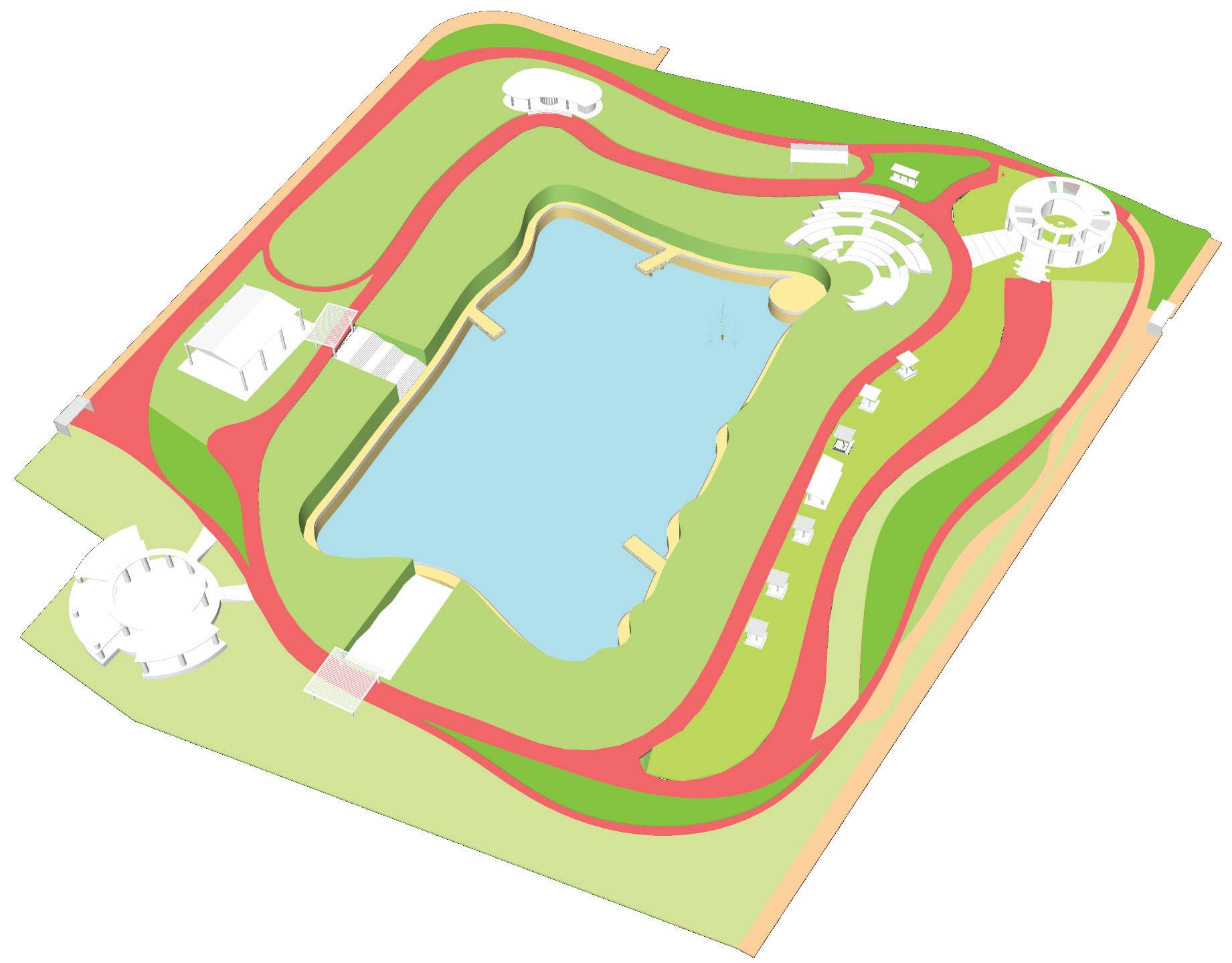
Justice Shahabuddin Ahmed Park is a landmark urban regeneration project in Gulshan, Dhaka, designed to transform a previously underutilised and gated green space into an inclusive, vibrant, and sustainable public realm. During my tenure at Vitti Architects I led the project from inception to the handover with a focus on preserving its rich biodiversity of 1,765 trees while creating accessible, multi-generational spaces. Key features include five distinct types of walkways to enhance user experience and suppor t groundwater recharge, a revitalized central pond with lower-level waterfront walkways and cycle tracks, and community amenities such as a library café, women’s seating areas, prayer space, gymnasium, children’s play zones, and exercise yards. The design also incorporates a green amphitheatre, performance deck, and multiple viewing platforms, fostering social interaction and cultural events. Sustainable landscaping with diverse planting, integrated drainage, and rainwater harvesting further enhances the ecological value of the park. As one of the first urban design projects in Bangladesh to achieve five UN Sustainable Development Goals (SDGs), the park sets a new standard for people-centred, eco-friendly public space in Dhaka, prioritising community well-being, environmental stewardship, and urban resilience.
DHAKA CITY
GULSHAN AVENUE
DESIGN STRATEGIES
Duration: 04 Years (2017 – 2020)
Status: Completed
Scale: City Scale Area: 9.45 Acres
Typology: Preserved Public Green
Budget: 17 Crore BDT.
Client: Local Government
Existing Biodiversity 1765
Existing

DESIGN IDEAS

DESIGN OBJECTIVES
INTEGRATED DESIGN APPROACH
The design of Justice Shahabuddin Park followed a community-led consultation process to ensure the park met local needs. Key methods included:
Community Workshops: Engaged residents, local groups, and park users to identify priorities and challenges.
Participatory Tools Used Participatory Rapid Appraisal (PRA) and visual exercises to gather input from diverse groups, including children and the elderly.
Stakeholder Coordination: Worked with local authorities and community representatives to align the design with wider development goals.

Integrated Design Approach

Feedback Integration: Community feedback was incorporated at each stage to refine the design and build long-term ownership. 0310172330FT


On-Site Design Workshop with the Community

AFTER COMPLETION


Cafe & Toilet
Amphitheatre & Performance Deck
Sitting Kisok
Brick Walkway & Cycle Lane
Basketball Court Deck 02
Cycle Lane & CC Walkways
Walkways
CHALLENGES INITIATIVES
Balancing Community Needs with Local Planning Requirements.
Preserving the Natural Setting
Balancing Political Pressure
Stakeholder Engagement and Negotiations
Integrated Design Approach and On-Site Workshop
Repositioning the Designed Layout
ACHIEVEMENTS
Inclusivity, Equality and Equity


SDG ACHIEVED
Green Space, Habitats, and Biodiversity (SDG 15)
Habitat and Biodiversity Conservation and Restoration.
Health and Well-Being (SDG 3)
Creation of opportunities for relaxation and recreation.
Inclusive and Effective Governance (SDG 16)
Effective management
Social Justice, Cohesion, and Equity (SDG 10)
Social interaction.


Cities have the capability of providing something for everybody, only because, and only when, they are created by everybody.
Jane Jacobs, The Death and Life of Great American Cities