

URBAN DESIGN PORTFOLIO


International Plannng & Urban Design (IPUD) School of Geography & Planning, Cardiff University/ 2022-23
Jinnurain Tasbir Shatil
INTEGRATED URBAN MIXED-USE DEVELOPMENT
This project is a project of my Urban Design Studio for the ‘Designing Cities’ module in my M.Sc. in International Planning and Urban Design (IPUD) at Cardiff University’s School of Geography and Planning. The module provided an opportunity to synthesise contextual information and theoretical concepts, leading to a comprehensive master plan for a fully integrated urban mixed-use development.
I selected a site within Butetown, Cardiff, analysing its urban quality, key challenges, and opportunities to enhance the area from an urban design perspective. Known as ‘Tiger Bay,’ Butetown has a rich multicultural history shaped by migration during Cardiff’s industrial boom. Its diverse communities have preserved their cultural heritage through festivals, fairs, and public events, often in shared public green or community spaces. Inspired by this tradition, my design emphasises public green spaces as social hubs, fostering inclusivity, cultural identity, and community interaction.
This project documents my design evolution, from site analysis and conceptual framework to the final masterplan, integrating residential, commercial, and community spaces. This project aims to contribute meaningfully to Butetown’s quality of life by critically analysing the existing urban fabric, demonstrating the power of theory-driven, context-sensitive urban design.
CARDIFF
BUTETOWN
PROPOSED SITE
• The site has very good accessibility from the surrounding areas.
• Butetown acts as the connector between City Centre & Cardiff Bay.
• There are no continuous bicycle and pedestrian networks for the dwellers.
• There is no vehicular access from Dumballs Road to Bute Street.
• There are different types of nodes which represents the intersections.
PERMEABILITY
PUBLIC SPACE & URBAN BLOCKS
LANDSCAPE

• There are fairly permeable, very permeable and less permeable areas in the site which have been divided by dumballs road and Lloyd George Ave.
• The dead ends have obstackled the permeability in some parts.
• The landmarks are significant and they are different in size, height, use and architectural expressions.
• All the public spaces are within a catchment area of 800 meters or 10 minutes of walking distance from the adjacent neighbourhoods.
• Public spaces are vertically connected.
• Lack of public space networks and horizontal connectivity.
• There are different types of public spaces according to their shape, size and usage.
• Large chunks of green spaces with facilities are serving the adjacent neighbourhoods.
• All the green spaces are in catchment diameter of 800 meters or 10 minutes walking distance from the neighbourhoods.
• Accessible green spaces are inadequate in comparison with open spaces on both sides of Dumballs road.
LAND-USE
BUILDING HEIGHTS
DWELLING AGES
CRIME & SAFETY
• Residential areas dominate, with commercial hubs along key routes. Public sector buildings, education, healthcare, and religious institutions enhance community services.
• Green spaces and vacant lands offer recreation and development potential, while parking and police stations support accessibility and safety.
• This land-use pattern fosters connectivity, mixed-use development, and community well-being.
• Low-rise buildings (≤10m) – Found in residential zones, fostering a pedestrian-friendly environment, enhancing walkability, community interaction, and open spaces.
• Mid-rise structures (10.1m–40m) – Comprise mixed-use and commercial developments, balancing density, connectivity, and functionality.
• High-rise buildings (40.1m and above) – Located near transit nodes and the waterfront, shaping Butetown’s skyline and supporting economic activity.
• Pre-1900 to 1939 – Historic terraced housing from Cardiff’s maritime boom.
• 1945–1972 – Post-war social housing and mid-rise developments.
• 1973–1999 – Urban renewal with mixed-use and higher-density housing.
• 2000–Post-2009 – Modern sustainable developments integrating public spaces.
• High Crime (21-25%): Found in less permeable areas near major roads.
• Moderate Crime (11-20%): Around landmarks and mixed-use zones.
• Low Crime (1-10%): In well-connected, high-visibility areas.
• Barriers (Dumballs Rd, Lloyd George Ave) and dead ends hinder safety.
DESIGN STRATEGIES
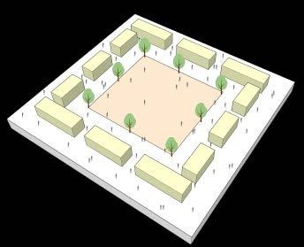
CENTRAL GREEN SPACE:

Creating a central open green space to serve the community for different purposes. It will be the interaction hub for the whole community, with good permeability. So that people can come from other parts of the site at any time and make the site more interactive.
GREEN SPACE NETWORK:

Creating a green space alongside the river tuff and some pocket green spaces all over the site to establish a green space network to enhance the recreational facility of the community. These green spaces will also help create a diversified community as people outside will also gather here.
ACCESSIBLE PUBLIC SPACE:
Creating more public spaces that are easily accessible. So that people in and outside the community or different parts of the cities can come to the public areas and enjoy every aspect of urban life in the accessible public space.
PERMEABILITY & LEGIBILITY:

Creating an area with good permeability and legibility. So that people can move easily, quickly and frequently from one point to another while feeling safe. It will eventually help establish an integrated connection with different parts of the city.
SEPARATE ZONING & BUFFERING:

Creating separate zones such as a mixed-used zone, residential zone and community zone and open green spaces between these zones so that they can act as a buffer space. These buffer zones can also act as connectors between these zones to have an integrated community.
INTERNAL COMMUNITY SPACE

Creating Internal community spaces those will enhance the social cohesion of the communities. The community can also be benefitted from these spaces fostering an insluesiveness.
URBAN FABRIC & BUILT FORM:

Integrating local urban fabric and building forms to enhance familiarity with the community's context.
ACTIVE TRAVEL NETWORK:

Creating continuous and uninterrupted pedestrian and bicycle connections for easy and quick movement to form an active travel network within different parts of the city to reduce dependency on motor vehicles.
DESIGN VISION & CONCEPT
VIBRANT COMMUNITY
Designing a Vibrant Community, that integrates Urban Life, Social Cohesion, Community Interaction, Celebration, and Public Green Spaces into a cohesive framework. This can be achieved through a human-centred, mixed-use development that combines residential, commercial, and recreational spaces with nature and public realms, so that people can enjoy their urban life and celebrate the joy of living fostering a sense of belongingness to the community.
CONCEPT FRAMEWORK

Urban Life : A dynamic mix of residential, commercial, and workspaces to encourage active street life and economic vitality.

Social Cohesion Plazas, community centres, and shared amenities that promote interaction among diverse social groups.

Community Interaction : Well-designed streetscapes, walkable neighbourhoods, and engaging public spaces to foster local engagement.
KEY URBAN DESIGN ELEMENTS
Central Public Space as a focal point for community activities.
Green Corridors & Pocket Parks linking different zones.
Pedestrian and Bicycle-Friendly Streets for sustainable urban mobility.
Mixed-Use Blocks that accommodate living, working, and leisure.
Waterfront Activity with walkways and gathering spaces.
Community Hubs to enhance social networks and shared experiences.


of Life : Cultural spaces, event hubs, and leisure areas that enhance the community’s vibrancy.
Public Green Spaces : Integrated parks, river fronts, and green corridors to promote well-being and sustainability.
CONCEPT SKETCH

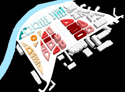
MASTER PLAN

MASTER PLAN OVERVIEW


ILLUSTRATIONS


Central Green Space
Community Hub and Street
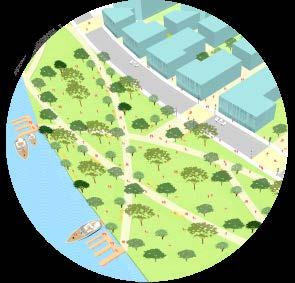
River-side Green Park
Green Space Connection with Vale College
Connectivity with Residential Zone