Part Eleven
The Planning and Zoning Code of Portsmouth, Ohio
Title Three: Zoning Code

For the promotion of public health, safety, convenience, comfort, prosperity, and general welfare.

The Planning and Zoning Code of Portsmouth, Ohio
For the promotion of public health, safety, convenience, comfort, prosperity, and general welfare.
1131.01 DESIGNATION
Title Three of Part Eleven is hereby established and referred to as the Zoning Code.
1131.02 EFFECTIVE DATE
This Zoning Code shall be in force on the earliest date allowed by law.
1131.03 PURPOSE
The regulations in this Zoning Code are established for the promotion of public health, safety, convenience, comfort, prosperity, and general welfare.
1131.04 JURISDICTION
The provisions of the Zoning Code shall apply to all land, structures, and uses now within and hereafter annexed to the city.
1131.05 REPEAL OF PRIOR ZONING CODE
This Zoning Code replaces and effectively repeals any prior zoning ordinance in effect in the city. All ordinances or parts of ordinances of the City, in conflict with any regulation, provision, amendment or supplement of this Zoning Code are, to the extent of such conflict, hereby repealed.
Any enforcement action pending under the prior zoning ordinance at the date of enactment of this Zoning Code shall continue, provided that the violation is not made legal by the enactment of this Zoning Code.
1131.06 CONTINUANCE
The Zoning Code shall not require any change in the plans, construction, size, or designed use of a structure for which a valid permit has been issued or lawfully approved before the effective date of this Zoning Code, provided, however, that construction under such permit or approval is started within two months of the effective date of this Zoning Ordinance, and provided that ground story framework, including structural parts of the second floor, if any, is completed within one year of the effective date of this Zoning Code.
Nothing contained in this Zoning Code shall affect the validity or effectiveness of an existing Conditional Use Permit issued under the prior zoning ordinance and as thereafter amended and effective prior to the enactment of this Zoning Code.
The Planning and Zoning Code of Portsmouth, Ohio
Where the provisions of this Zoning Code establish greater restrictions on a lot, a structure, or a use than the provisions of any other ordinance or regulation, private deed restriction, or private covenant, the provisions of this Zoning Code shall govern. Where the provisions of another ordinance, regulation, private deed restriction, or private covenant establish greater restrictions than the provisions of this Zoning Code, then provisions of the other ordinance, regulation, private deed restriction, or private covenant shall govern.
The provisions of this Zoning Code are not intended to nullify, abolish, or repeal any easement, covenant, or other private agreement or restriction.
Compliance with this Zoning Code is required. Failing to comply with the regulations of the Zoning Code shall constitute a violation of its provisions.
If any section, subsection, sentence, clause, or phrase of this Zoning Code is held to be invalid, such invalidity shall not affect the validity of the remaining portions of this Zoning Code.
(a) Except as hereinafter provided, no structure or part thereof shall be moved, erected, converted, enlarged, reconstructed, or structurally altered except in compliance with the regulations of this Zoning Code.
(b) No structure or land shall be used or occupied except in compliance with the regulations of this Zoning Code.
(c) No structure shall be erected or structurally altered except when such structure is located on a lot.
(d) No lot shall be created or changed in dimension or area except in conformity with the requirements set forth in this Zoning Code.
(a) Interpretation of Terms and Words
(1) Except where specifically defined in the Zoning Code, all words used herein shall carry the meanings contained in a dictionary of common usages.
(2) Words used in the present tense include the future tense; the singular number includes the plural; the word “structure” includes the word “building;” the word “lot” includes the word “plot” or “parcel;” the term “shall” is always mandatory; the word “may” is permissive; the words “used” or “occupied,” as applied to any land or structure, shall be construed to include the words “intended, arranged, or designed to be used or occupied.”
(b) Interpreting Conjunctions
Where a regulation involves two or more items, conditions, provisions, or events which are connected by a conjunction “and,” “or,” or “either...or” the conjunction shall be interpreted as follows:
(1) “And” indicates that all the connected items, conditions, provisions, or events shall apply.
(2) “Or” indicates that the connected items, conditions, provisions, or events may apply singly or in any combination.
(3) “Either ... or” indicates that all the connected items, conditions, provisions, or events shall apply singly but not in combination.
(c) Interpreting Text and Graphics
(1) Text in the Zoning Code is regulatory.
(2) Graphics in the Zoning Code are illustrative unless specifically captioned as regulatory.
(d) Interpreting Zoning Map Boundaries
(1) Boundaries indicated as approximately following the centerlines of streets, highways, or alleys; platted lot lines; municipal limits; railroad lines; or the centerlines of streams, rivers, canals, lakes, or other bodies of water shall be construed as such.
(2) Where district boundaries are so indicated that they are approximately parallel to the center lines or street lines of streets, or the center lines or right-of-way lines of highways, such district boundaries shall be construed as being parallel thereto and at such distance therefrom as indicated on the Zoning Map. If no distance is given, such dimension shall be determined by the use of the scale shown on the Zoning Map.
(3) Where a district boundary line divides a lot that was in single ownership at the time of passage of this Zoning Code, the Building Officer may permit the extension of the regulations for either portion of the lot beyond the district line into the remaining portion of the lot.
(a) Measuring Lot Dimensions
(1) A lot extends to its lot lines, which should be coterminous with the lot lines of abutting lots or with the boundaries of a public right-of-way.
(2) Area dimensions are measured on a horizontal plane in plan view and do not consider topography or the actual surface area of non-level ground.
(3) Areas of lots that are occupied by easements, such as access or utility easements, contribute to total lot area and are considered in calculating impervious coverage and other standards.
(4) Lot frontage is the aggregate length of all front lot lines.
(5) Impervious coverage is the percent of the lot’s horizontal plane that is occupied by impervious, man-made materials, including buildings, asphalt, concrete, swimming pools, barns, and carports, but excluding porous pavement, permeable pavers, decks with gaps between decking for drainage, lawn grasses, gardens, and other landscaping.
(b) Measuring Setbacks
(1) When measuring a required distance, such as the minimum setback, the measurement is made at the point where the two entities are closest.
(2) Where a lot borders two streets that do not intersect at a corner of the lot, such as in a through lot, two front lot lines will exist, one along each right-of-way. The required front setback must be provided for each street frontage.
(3) When a lot borders two or more streets that intersect at the corner(s) of the lot, such as in a corner lot, the front setback shall be provided for each street frontage.
(4) When a lot borders one street with an acute curve of 55 degrees or more so that the street effectively creates two sides of the lot, the lot line(s) along that street shall be considered a front lot line, and a front setback shall be applied to the entire lot frontage.
(5) Lot lines abutting alleys are not considered front lot lines and do not require front setbacks.
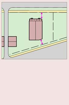
(c) Measuring Structure Height
(1) Structure height is measured as the difference in elevation of:
(i) A horizontal line at the average grade along the structure’s front elevation; and
(ii) The highest point of the roof, including parapets and cornices.
(2) Exceptions
(i) Renewable energy generation systems may exceed the maximum structure height defined for the district by up to five feet.
(ii) Chimneys, elevators, poles, spires, tanks, towers, and other similar projections may exceed the maximum structure height defined for the district by up to 14 feet.
(iii) Spires and steeples on structures used for religious assembly shall not be subject to structure height limitations.
The lot frontage of a corner lot is the sum of the lengths of the two street frontages, represented by pink arrows. The alleyway on the right side of the figure does not constitute a street right-of-way for the purposes of this Zoning Code, and the lot line that abuts the alleyway is, therefore, not included in the measurement of lot frontage.
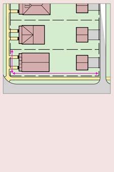

The front setbacks (represented by pink arrows) are measured from front lot lines to the nearest point on the nearest structure. This lot has two front lot lines and, therefore, two front setbacks. Note that the alleyway on the left side of the figure does not constitute a street rightof-way for the purposes of this Zoning Code, and, therefore, a front setback is not applied at the alleyway. The front steps are not considered when measuring the
1131.14 HOW TO NAVIGATE THIS CODE
(a) Step One: Locate your property and applicable district on the Zoning Map.
(b) Step Two: Review the applicable district regulations in Chapter 1133.
(c) Step Three: Review the applicable use, building placement, landscaping and signage regulations in Chapters 1135 and 1137.
(d) Step Four: Learn how to address any nonconformities in Chapter 1139.
(e) Step Six: Determine which approvals are necessary and how to apply for them in Chapter 1141.
(f) Step Seven: Reference the Glossary for use and general terms in Chapter 1143.


The graphic above shows the structure height. It spans the difference in elevation between the horizontal line at the average grade along the structure’s front elevation and the top of the roof (upper pink dashed line).
The graphic above shows the structure height as the length of the pink arrow. It spans the difference in elevation between the horizontal line at the average grade along the structure’s front elevation (lower pink dashed line) and the top of the roof (upper pink dashed line).
Chapter
(a) Establishment of the Zoning Map
(1) The city is divided into distinct geographic areas, known as districts, as shown on the Zoning Map, which, together with all explanatory matter thereon, is adopted by reference and declared to be a part of this Zoning Code.
(2) Districts are intended to promote compatible land uses within a defined geographic area by establishing limitations on the use, placement, and scale of structures within the district.
(3) The Zoning Map shall be the final authority as to the current district status of lots in the city and any structures built upon such lots.
(4) No changes of any nature shall be made to the Zoning Map or matter shown thereon except in accordance with the procedures set forth in this Zoning Code. Any unauthorized change of whatever kind by any person or persons shall be considered a violation of this Zoning Code.
(5) The Zoning Map shall be maintained in an accurate manner and available to the public at the City’s offices and online at http://www.sciotocountyengineer.org/oneview/.
(b) List of Districts
The city includes the following districts:
(1) Rural District (R)
(2) Hillside Neighborhood District (HN)
(3) Traditional Neighborhood District (TN)
(4) Downtown District (D)
(5) Corridor District (C)
(6) University District (U)
(7) Medical District (M)
(8) Industrial Flex District (IF)
(9) Parks and Open Space District (P)
(c) Compliance with Regulations
Specific standards are applicable to each district are set forth in this chapter. Additional applicable development standards are included elsewhere in the Zoning Code, such as use-specific standards in Chapter 1135 and generally applicable standards in Chapter 1137.
Below are illustrative graphics indicating the measures of lot frontage, front setback, side setback, rear setback, lot area, and impervious coverage. These dimensional terms are also defined in the Glossary, Chapter 1143.

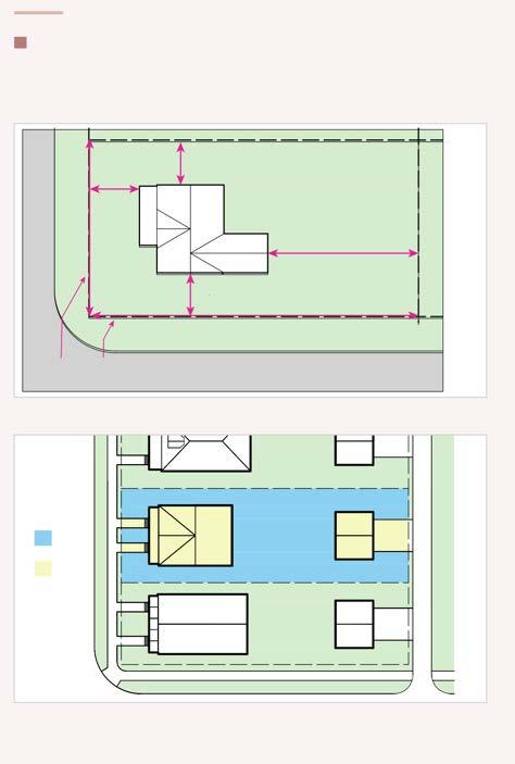
Lot frontage (length of both lot lines)
5: Illustration of lot frontage, front setback, side setback, and rear setback dimensions.
Only the following uses are permitted in this district. No lot may have more than one principal use.
(In the list below, “C” indicates a use that is conditionally permitted. “A” indicates a use that may be accessory to a principal use. For more details, see the Comprehensive Use Table and use-specific standards in Chapter 1135.)
Agricultural
• Agriculture
• Neighborhood Agriculture
Industrial
• Artisan Manufacturing
Institutional
• Government Services
• Religious Place of Worship
• School (C)
Lodging
• Small Lodging (A)
Parking
• Large Surface Parking (A)
• Small Surface Parking (A)
Recreation and Leisure
• Conservation Recreation
• Medium Outdoor Recreation
• Recreational Lodging
• Small Outdoor Recreation
Residential
• Dwelling
Services
• Air Transport Services (C)
• Animal Care
• Automotive Services
• Family Care Services
• Professional Services
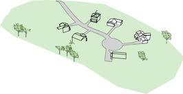
The Rural District intends to promote rural character and geological stability through large lots and low-intensity uses.
Only the following uses are permitted in this district. No lot may have more than one principal use.
(In the list below, “C” indicates a use that is conditionally permitted. “A” indicates a use that may be accessory to a principal use. For more details, see the Comprehensive Use Table and use-specific standards in Chapter 1135.)
Agricultural
• Agriculture
• Neighborhood Agriculture (A)
Industrial
• Artisan Manufacturing
Institutional
• Government Services (C)
• Religious Place of Worship (C)
• School (C)
Parking
• Small Surface Parking (A)
Recreation and Leisure
• Conservation Recreation
• Small Outdoor Recreation
Residential
• Dwelling
Services
• Animal Care
• Family Care Services
The Hillside Neighborhood District intends to support low-density residential development compatible with steep topography.
Front Setback


Only the following uses are permitted in this district. No lot may have more than one principal use.
(In the list below, “C” indicates a use that is conditionally permitted. “A” indicates a use that may be accessory to a principal use. For more details, see the Comprehensive Use Table and use-specific standards in Chapter 1135.)
Agricultural
• Neighborhood Agriculture (A) Industrial
• Artisan Manufacturing Institutional
• Government Services (C)
• Religious Place of Worship
• School (C) Parking
• Small Surface Parking (A)
• Structured Parking (C) (A) Recreation and Leisure
• Conservation Recreation
• Indoor Recreation or Leisure (C)
• Large Outdoor Recreation (C)
• Medium Outdoor Recreation
• Restaurant or Bar
• Small Scale Outdoor Recreation Residential
• Dwelling Retail
• Large Retail (C)
• Small Retail Sales
• Automotive Sales (C)
• Commercial Sales (C) Services
• Animal Care (C)
• Automotive Services (C)
• Car Rental Services
• Commercial Services (C)
• Family Care Services
• General Personal Services
• Professional Services
The Traditional Neighborhood District intends to support mediumdensity residential uses in well-connected, walkable neighborhoods.
Front Setback
Side Setback
Rear Setback
Structure Height
Impervious Coverage
ft. min.
ft. min.
ft. max.
max.
No parking area may be situated closer to the front lot line than any front-facing exterior wall of any principal structure(s) on the same lot, except in the case of through-lots. If the parking area is located on a lot that does not contain a principal structure, refer to the parking area regulations in Section 1137.03 (b).
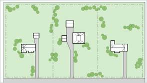
Figure 9: An illustrative graphic showing a possible development pattern in the Traditional Neighborhood District.
Only the following uses are permitted in this district. More than one principal use per lot is permitted.
(In the list below, “C” indicates a use that is conditionally permitted. “A” indicates a use that may be accessory to a principal use. For more details, see the Comprehensive Use Table and usespecific standards in Chapter 1135.)
Industrial
• Artisan Manufacturing
• Small Light Industrial Institutional
• Arts, Science, and Cultural
• Government Administration
• Government Services
• Religious Place of Worship
• School Lodging
• Large Lodging
• Small Lodging (A) Parking
• Large Surface Parking (A)
• Small Surface Parking (A)
• Structured Parking (A) Recreation and Leisure
• Conservation Recreation
• Indoor Recreation or Leisure
• Restaurant or Bar
• Small Outdoor Recreation Residential
• Cooperative Dwelling
• Dwelling Retail
• Large Retail
• Small Retail Sales
• Automotive Sales
• Commercial Sales Services
• Animal Care
• Automotive Services
• Car Rental Services
• Commercial Services
• Family Care Services
• General Personal Services
• Ground Transport Services
• Professional Services
The Downtown District promotes the development of medium-to-highdensity residential and commercial uses in walkable, highly connected neighborhoods.
Front Setback 0 ft. min.
Side Setback
ft. min.
Rear Setback 30 ft. min.
Structure Height
100 ft. max.; elevator or stair penthouses may exceed the height limit by 12 ft. if set back at least 20 ft. from roof edge
Impervious Coverage N/A
No parking area may be situated closer to the front lot line than any frontfacing exterior wall of any principal structure(s) on the same lot, except in the case of through-lots. If the parking area is located on a lot that does not contain a principal structure, refer to the parking area regulations in Section 1137.03 (b).
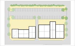
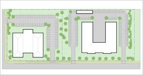
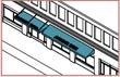
Figure 10: An illustrative graphic showing a possible development pattern in the Downtown District.
Only the following uses are permitted in this district. More than one principal use per lot is permitted.
Agricultural
• Neighborhood Agriculture (A) Industrial
• Artisan Manufacturing
• Heavy Industrial (C)
• Large Light Industrial (C)
• Small Light Industrial Institutional
• Arts, Science, and Cultural
• Government Administration
• Government Services
• Religious Place of Worship
• School Lodging
• Large Lodging
• Small Lodging (A) Parking
• Large Surface Parking (A)
• Small Surface Parking (A)
• Structured Parking (A) Recreation and Leisure
• Conservation Recreation
• Indoor Recreation or Leisure
• Large Outdoor Recreation
• Medium Outdoor Recreation
• Restaurant or Bar
• Small Outdoor Recreation Residential
• Dwelling Retail
• Large Retail
• Small Retail Sales
• Automotive Sales
• Commercial Sales Services
• Addiction Treatment Facility
• Animal Care
• Automotive Services
• Car Rental Services
• Commercial Services
• Emergency Medical Care
• Family Care Services
• General Personal Services
• Ground Transport Services
• Professional Services
The Corridor District promotes commercial and residential uses surrounding the U.S. Route 52 and U.S. Route 23 corridors.
Setback
Setback
Rear Setback
Structure Height
ft. min. for a rear yard that abuts only non-residential uses; 40 ft. min. for a rear yard that abuts a residential use
ft. max. Impervious Coverage
max.
No parking area may be situated closer to the front lot line than any frontfacing exterior wall of any principal structure(s) on the same lot, except in the case of through-lots. If the parking area is located on a lot that does not contain a principal structure, refer to the parking area regulations in Section 1137.03 (b).
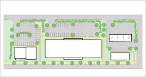
Figure 11: An illustrative graphic showing a possible development pattern in the Corridor District.
In the use list, “C” indicates a use that is conditionally permitted. “A” indicates a use that may be accessory to a principal use. For more details, see the Comprehensive Use Table and use-specific standards in Chapter 1135.
Only the following uses are permitted
The University District promotes a mix of residential, commercial, and in this district. More than one principal use per lot is permitted.
Agricultural
• Agriculture
• Neighborhood Agriculture (A) Industrial
• Artisan Manufacturing
• Small Light Industrial Institutional
• Arts, Science, and Cultural
• Government Administration
• Government Services
• Religious Place of Worship
• School Lodging
• Large Lodging
• Small Lodging (A) Parking
• Large Surface Parking (A)
• Small Surface Parking (A)
• Structured Parking (A) Recreation and Leisure
• Conservation Recreation
• Indoor Recreation or Leisure
• Large Outdoor Recreation
• Medium Outdoor Recreation
• Restaurant or Bar
• Small Outdoor Recreation Residential
• Cooperative Dwelling
• Dwelling Retail
• Large Retail
• Small Retail Services
• Air Transport Services (C)
• Animal Care
• Automotive Services
• Car Rental Services
• Commercial Services
• Emergency Medical Care
• Family Care Services
• General Personal Services
• Ground Transport Services
• Professional Services
institutional uses within and surrounding the campus of Shawnee State University.
Front Setback
Side Setback
Rear Setback
Structure Height
Impervious Coverage
20 ft. min. when abutting a lot outside of the University District; 0 ft. min. when abutting a lot within the University District
ft. max.
max.
No parking area may be situated closer to the front lot line than any frontfacing exterior wall of any principal structure(s) on the same lot, except in the case of through-lots. If the parking area is located on a lot that does not contain a principal structure, refer to the parking area regulations in Section 1137.03 (b).
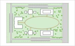
Figure 12: An illustrative graphic showing a possible development pattern in the University District.
In the use list, “C” indicates a use that is conditionally permitted. “A” indicates a use that may be accessory to a principal use. For more details, see the Comprehensive Use Table and use-specific standards in Chapter 1135.
Only the following uses are permitted
The Medical District is intended to promote mixed-use development within in this district. More than one principal use per lot is permitted.
(In the list below, “C” indicates a use that is conditionally permitted. “A” indicates a use that may be accessory to a principal use. For more details, see the Comprehensive Use Table and use-specific standards in Chapter 1135.)
Institutional
• Arts, Science, and Cultural
• Government Administration
• Government Services
• Religious Place of Worship
• School Lodging
• Large Lodging
• Small Lodging (A) Parking
• Large Surface Parking (A)
• Small Surface Parking (A)
• Structured Parking (A)
Recreation and Leisure
• Indoor Recreation or Leisure
• Restaurant or Bar
• Small Outdoor Recreation Retail
• Small Retail Services
• Air Transport Services (C)
• Animal Care
• Commercial Services
• Emergency Medical Care
• Family Care Services
• General Personal Services
• Ground Transport Services
• Professional Services
and surrounding Portsmouth’s hospital center.
Front Setback
Side Setback
Rear Setback
Structure Height
Impervious Coverage
20 ft. min. when abutting a lot outside of the Medical District; 0 ft. min. when abutting a lot within the Medical District
ft. max.
max.
No parking area may be situated closer to the front lot line than any frontfacing exterior wall of any principal structure(s) on the same lot, except in the case of through-lots. If the parking area is located on a lot that does not contain a principal structure, refer to the parking area regulations in Section 1137.03 (b).
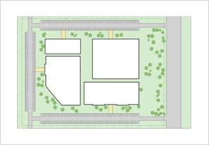
Figure 13: An illustrative graphic showing a possible development pattern in the Medical District.
Only the following uses are permitted
The Industrial Flex District intends to promote industrial and other in this district. More than one principal use per lot is permitted.
(In the list below, “C” indicates a use that is conditionally permitted. “A” indicates a use that may be accessory to a principal use. For more details, see the Comprehensive Use Table and use-specific standards in Chapter 1135.)
Adult
• Adult Use
Industrial
• Artisan Manufacturing
• Heavy Industrial
• Large Light Industrial
• Small Light Industrial
Institutional
• Government Services
Lodging
• Small Lodging (A) (C)
Parking
• Large Surface Parking (A)
• Small Surface Parking (A)
• Structured Parking (A)
Recreation and Leisure
• Restaurant or Bar
• Small Outdoor Recreation
Retail
• Small Retail Sales
• Automotive Sales
• Commercial Sales
Services
• Addiction Treatment Facility
• Automotive Services
• Car Rental Services
• Commercial Services
• Ground Transport Services
• Professional Services
commercial uses along railroad, highway, and river transportation corridors.
Front Setback 20 ft. min.
Side Setback
Rear Setback
0 ft. min. for a side yard that abuts only non-residential uses; 40 ft. min. for a side yard that abuts a residential use
0 ft. min. for a rear yard that abuts only non-residential uses; 40 ft. min. for a rear yard that abuts a residential use
Structure Height 90 ft. max.
Impervious Coverage 90% max.
No parking area may be situated closer to the front lot line than any frontfacing exterior wall of any principal structure(s) on the same lot, except in the case of through-lots. If the parking area is located on a lot that does not contain a principal structure, refer to the parking area regulations in Section 1137.03 (b).
14: An illustrative graphic showing a possible development pattern in the Industrial Flex District.
Only the following uses are permitted
in this district. More than one principal use per lot is permitted.
(In the list below, “C” indicates a use that is conditionally permitted. “A” indicates a use that may be accessory to a principal use. For more details, see the Comprehensive Use Table and use-specific standards in Chapter 1135.)
Agricultural
• Agriculture
• Neighborhood Agriculture (A)
Institutional
• Arts, Science, and Cultural (C)
• Government Administration
• Government Services
Parking
• Small Scale Surface Parking (A)
• Large Scale Surface Parking (A)
• Structured Parking (A)
Recreation and Leisure
• Conservation Recreation
• Medium Outdoor Recreation
• Recreational Lodging
• Restaurant or Bar
• Small Outdoor Recreation
The Parks and Open Space District is intended to promote environmental
and recreational wellness through the protection of nature preserves, parklands, and natural resources management areas.
No parking area may be situated closer to the front lot line than any frontfacing exterior wall of any principal structure(s) on the same lot, except in the case of through-lots. If the parking area is located on a lot that does not contain a principal structure, refer to the parking area regulations in Section 1137.03 (b).
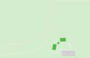

15: An illustrative graphic showing a possible development pattern in the Parks and Open Space District. The Planning and Zoning Code of Portsmouth, Ohio
1135.01 INTRODUCTION TO USES
(a) Allowed Uses
Land and structures may only be used or intended to be used for purposes expressly permitted by the Comprehensive Use Table of this Zoning Code.
(1) Permitted Uses. A permitted use is subject to administrative approval.
(2) Conditionally Permitted Uses. A conditionally permitted use is subject to quasi-judicial approval by the Board of Zoning Appeals. The Board of Zoning Appeals may in addition to zone- or district-specific development standards set forth in Chapter 1133; in addition to any use-specific standards set forth in Chapter 1135; and in addition to any generally applicable standards set forth in Chapter 1137 set forth requirements that will, in its judgment, render the conditionally permitted use compatible with the existing and future use of adjacent lots and the vicinity.
(b) Uses Not Listed
No land or structure may be used for any purpose not expressly listed in the Zoning Code as permitted or conditionally permitted unless such use is determined by the Building Officer to be similar in definition and impact to a permitted or conditionally permitted use.
(c) Similar Uses Not Listed
(1) Any person may submit to the Building Officer an application for zoning approval for any use of land or structure
that is similar in definition and impact to a permitted or conditionally permitted use.
(2) The Building Officer shall then determine whether the use is similar in definition and impact to a listed permitted or conditionally permitted use. If, in the judgment of the Building Officer, the use is similar in definition and impact to a listed permitted or conditionally permitted use, the proposed use shall be determined to be likewise permitted or conditionally permitted, and, provided that the proposed use complies with all other requirements of this Zoning Code, a zoning permit shall be issued.
(3) The applicant may appeal the decision of the Building Officer to the Commission. The Commission shall have the right to override the Building Officer’s determination if it should find that the determination was arbitrary, unreasonable, or capricious.
(4) The determination by the Building Officer or the Commission shall be for the purpose of enabling the applicant to otherwise comply with the zoning regulations regarding necessary applications or permits to be obtained. The decision shall in no way act as a commitment by the Commission or any other agency of the City as to future zoning, approval of conditional uses, or any other zoning matter.
(d) Use-Specific Regulations
Certain uses are subject to specific regulations, which are set forth in this chapter.
Table 1101.1: Comprehensive Use Table
Key: P = Permitted Use; C = Conditionally Permitted Use; (A) = A use which may be either an accessory use or a principal use.
Any use listed in the following sections of Chapter 1135 must comply with specific regulations, as listed hereafter.
(a) Accessory uses are permitted in all districts.
(b) All accessory uses must be operated in conjunction with a customarily associated principal use and must be subordinate to that principal use.
(c) An accessory use must be conducted on the same lot as the associated principal use or must be conducted on a lot that is contiguous to the lot occupied by the associated principal use.
(d) An accessory use shall not cause a greater impact on surrounding properties than those impacts which are customarily expected from permittable principal uses in that district.
(e) The impervious area of an accessory use shall be considered when calculating a lot’s impervious coverage.
(f) An accessory use must comply with front and side setback requirements applicable to the district in which it is located. An accessory use or structure must maintain a rear setback equal to the rear setback requirement of the district in which it is located or 10 feet, whichever is less, except that, in the case that a detached garage is located in a rear yard that abuts an alley, a detached garage must maintain a rear setback of only 5 feet. Fences are exempt from such front, side, and rear setbacks as described in Chapter 1137.
(g) An accessory use must comply with height limits applicable to the district in which it is located, unless otherwise noted in this Zoning Code.
(h) Determination of whether a use is “customarily associated with” and “subordinate to” the principal use of the lot shall be made by the Building Officer. Determination of whether an impact is greater than those impacts which are “customarily expected from permittable principal uses” shall be made by the Building Officer. Appeals of such determinations may be filed with the Board of Zoning Appeals.
(i) Examples of customarily associated accessory uses to dwellings include but are not limited to:
(1) Private swimming pools and hot tubs;
(2) Private garages;
(3) Patios, decks, and terraces;
(4) Vegetable or flower gardens;
(5) Fences;
(6) Renewable energy generation systems;
(7) Play equipment and swing sets;
(8) Storage sheds;
(9) Private parking pads;
(10) Au pair suites and caretaker dwellings; and
(11) Home occupations.
(a) An addiction treatment facility is permitted only when the below criteria is met.
(1) Number. No more than one addiction treatment facility may be permitted per each 15,000 persons residing in the city. The number of persons residing in the city shall be based on the most recent US Census Bureau estimate.
(2) Facilities. The facility shall provide for staff offices, sleeping space, meeting rooms, bathrooms, and kitchen and dining facilities.
(3) Supervision. On-site staff supervision shall be provided during all hours of human occupancy.
(4) Licensure. Licensure for the program operated at the facility shall be obtained in accordance with the Ohio Revised Code.
(b) Any permitted or accessory uses allowed in any district will not be interpreted to include addiction treatment facilities unless such use is specifically stated to include addiction treatment facilities.
(a) No adult use shall be established within a radius of 500 feet of any school, library, or teaching facility, whether public or private, if such school, library, or teaching facility is attended by persons under 18 years of age.
(b) All building openings, entries, windows, for adult uses shall be located, covered, or serviced in such a manner as to prevent a view into the interior from any public or semi-public area, sidewalk, or street.
(c) No screens, loudspeakers, or sound equipment shall be used for adult motion picture theaters (enclosed or drive-in) that can be seen or discerned by the public from public or semi-public areas.
Animal care uses must maintain a distance of 200 feet between outdoor runs and a dwelling use on another lot.
(a) Arts, science, and cultural uses must have a central mission of promoting the advancement of art, science, and/or culture and the delivery of art, science, and/or culture to the general public.
(b) Arts, science, and cultural uses may not have central missions to sell products, produce products to sell, or provide direct for-profit services.
(c) Research and development activities, universities, galleries that display art for the primary mission of selling art, and artist studios that are not open to public visitation are not considered arts, science, and cultural uses.
(d) Arts, science, and cultural uses may dedicate up to 25% of the principal structure to office uses in association with the management or development of the principal use.
Drive-thrus are accessory uses that are associated with principal commercial uses, such as restaurants, convenience stores, and pharmacies. Drive-thrus are regulated in Chapter 1137 Generally Applicable Standards.
(a) No dwelling may be erected that is not placed upon a permanent foundation, except when such dwelling is in the Rural District.
(b) No dwelling may be erected that is a mobile home, except when such dwelling is in the Rural District.
(a) A home occupation must be accessory to, subordinate to, and associated with a principal dwelling use on the same lot or adjacent lot.
(b) No person other than a resident of the associated principal dwelling use shall be engaged in a home occupation.
(c) There shall be no change in the outside appearance of the building or other visible evidence of the conduct of a home occupation that would alter a dwelling’s essential character.
(d) No home occupation shall be used in such a manner as to create offensive odors, noise, vibration, smoke, or other particulate matter, heat, humidity, glare, electronic interference, or otherwise constitute a nuisance or safety hazard to any occupant of adjacent or nearby properties.
(e) No home occupation shall store flammable, explosive, corrosive, unstable, volatile, or hazardous substances in quantities greater than those reasonably expected for a dwelling use. Whether a quantity is greater than that “reasonably expected for a dwelling use” shall be determined by the Building Officer.
(f) There shall be no outdoor storage associated with a home occupation.
(g) Vehicles used by customers of a home occupation shall be parked in a driveway, a parking area on the lot containing the home occupation, or along the street curb abutting the premises. Not more than four motor vehicles used by customers of a home occupation shall be parked at the location of a home occupation at one time.
(a) A neighborhood agriculture use may be a principal use of a lot or may be an accessory use that is subordinate to and associated with a principal use of a lot or an adjacent lot, such as a dwelling use.
(b) No more than one chicken, duck, rabbit, or similar small animal shall be kept for each 725 square feet of lot area. No roosters, geese, or turkeys may be kept outdoors except on lots of at least one-half acre where the coop or cage housing the animal(s) is at least 100 feet from all lot lines. No horse, cow, goat, pig, sheep, llama, alpaca, or similarly sized animal may be kept as part of a neighborhood agriculture use.
(c) All animals shall be provided with a covered, predator-proof coop or cage or other shelter that is thoroughly ventilated, designed to be easily accessed, maintained, and cleaned, and of sufficient size to
permit free movement of the animals, exclusive of areas used for storage of materials or vehicles.
(d) If the neighborhood agriculture use is an accessory use, any coops or cages housing animals may not be located closer to the street right-of-way than the principal structure on the lot.
(e) Compost. Compost heaps must maintain a setback of 10 feet from all lot lines.
(f) Hoop houses, animal shelters, and greenhouses must be included in impervious coverage calculations.
If a structure associated with an outdoor entertainment venue use is within 1,000 feet of a lot that permits dwelling uses, the hours of operations during which noise and light are produced must be restricted to 7:00 AM to 11:00 PM.
For porches that are not enclosed in walls or windows on at least three sides, the required front setback is eight feet less than the front setback applicable to principal structures in that district.
(a) Religious places of worship that operate accessory weekday educational classes for more than 100 children shall also be considered school uses.
(b) Religious places of worship that provide accessory residential amenities for religious or lay persons shall also be considered dwelling uses.
(a) Building-mounted renewable energy generation systems may exceed the height limitations in the district in which they are located, provided that they do not exceed the height limitation by more than three vertical feet.
(b) If pole-mounted, renewable energy generation systems must be set back from all lot lines a horizontal distance equal to the height of the structure.
(a) A small lodging use may not have more than 8 guest rooms per lot.
(b) A small lodging use may not occupy more than 5,000 square feet of GFA per lot.
(a) Purpose
The purpose of this section is to regulate the placement, construction and modification of towers and Wireless
Telecommunications Facilities in order to protect the health, safety and welfare of the public, while at the same time not unreasonably interfering with the development of the competitive wireless telecommunications marketplace in the city. Specifically, the purposes of this chapter are:
(i) To direct the location of towers and Wireless Telecommunications Facilities in the city.
(ii) To protect residential areas and land uses from potential adverse impacts of towers and Wireless Telecommunications Facilities.
(iii) To minimize adverse visual impacts of towers and Wireless Telecommunications Facilities through careful design, siting, and landscaping techniques.
(iv) To promote and encourage shared use/co-location of towers and Antenna Support Structures as a primary option rather than construction of additional single-use towers.
(v) To avoid potential damage to adjacent properties caused by towers and Wireless Telecommunications Facilities by ensuring such structures are soundly and carefully designed, constructed, modified, maintained and removed.
(vi) To the greatest extent feasible, ensure that towers and Wireless Telecommunications Facilities are compatible with surrounding land uses.
(vii) To the greatest extent feasible, ensure that proposed towers and Wireless Telecommunications Facilities are designed in harmony with natural settings and in a manner consistent with current development patterns.
(b) Applicability
(1) All towers, Antenna Support Structures, and Wireless Telecommunications Facilities, any portion of which are located within the city, are subject to this chapter.
(2) Except as provided in this chapter, any use being made of an existing tower or Antenna Support Structure on the effective date of this section (herein “Nonconforming Structures”) shall be allowed to continue even if in conflict with the terms of this section. Any tower site that has received City approval in the form of a Special Permit or building permit, but has not yet been constructed or located, shall be considered a Nonconforming Structure so long as such approval is current and not expired.
(c) Use Regulations
Wireless Telecommunications Facilities shall be a conditional use in the Industrial Flex District, contingent upon a number of requirements being met. These criteria are in place in an attempt to minimize adverse health, safety, public welfare or visual impacts through buffering, siting, design and construction, and reduction of the need for new towers.
(d) Application Requirements
The following additional information shall be provided when applying for a conditional use approval:
(1) A plot plan indicating all building uses within 200 feet of the proposed facility. Aerial photos and/ or renderings may be required.
(2) A diagram or map showing the viewshed of the proposed Wireless Telecommunications Facilities or Antenna Support Structure.
(3) Photo simulations of the proposed facility from affected residential properties and public rights-ofway at varying distances.
(4) A list of the location of every tower, building, or structure within the area that could support the proposed antenna. The applicant must show that it has pursued a reasonable shared use arrangement with the owner(s) of the existing towers and that such pursuit was unsuccessful.
(1) The tower and Equipment Shelter shall be 1,000 feet from the nearest dwelling use or public park.
(2) The maximum size of the Equipment Shelter shall not exceed 400 square feet.
(3) Minimum setback for the tower from all property lines shall be a distance equal to the height of the tower. Setback shall be defined as the distance from the property line to the nearest portion of the structure. The Equipment Shelter shall meet the minimum setback requirements applicable to accessory structures.
(4) Underground wiring to the site shall be required.
(5) Equipment, mobile or immobile, not used in direct support of the transmission or relay facility, shall not be stored or parked on the site except in connection with a repair or maintenance being made to the installation.
(6) The owner of the tower shall annually file with the Building Officer a declaration ascertaining the continued operations, according to the Board of Zoning Appeal’s approval, of each tower approved.
(7) Obsolete or unused facilities shall be removed within six months of ceasing operation.
(8) No employees shall be employed on a regular basis at the installation site.
(9) The location of the tower and Equipment Shelter and Antenna Support Structure shall comply with all natural resource protection standards established in the Zoning Code.
(10) Security fencing eight feet in height shall be required to surround the tower, Equipment Shelter and any guy wires, either completely or individually as determined by the Board of Zoning Appeals. No barbed or razor wire shall be permitted. The City and co-locators shall have reasonable access. No fence shall be required on top of a building or other structure if access to the roof or top of the structure or building is secure.
(11) Buffer plantings shall be located around the perimeter of the security fence as deemed appropri- ate by the Board of Zoning Appeals. Options are an evergreen screen to be planted that consists of either a hedge, planted three feet on center maximum, or a row of evergreen trees planted five feet on center maximum, or other screens determined to be appropriate by the Board of Zoning Appeals.
(12) Existing vegetation (trees and shrubs) shall be preserved to the maximum extent possible.
(13) The tower shall be painted a non-contrasting gray or similar color minimizing its visibility, unless otherwise required by the Federal Communications Commission (FCC) or Federal Aviation Administration (FAA).
(14) Except for tower or Monopole structures, all appurtenances shall be aesthetically and architecturally compatible with the surrounding environment.
(15) No advertising is permitted anywhere on the Wireless Telecommunications Facility, with the exception of identification signage.
(16) No tower under 150 feet shall be artificially lighted except to assure safety or as required by the Federal Aviation Administration.
(17) “No Trespassing” signs shall be posted around the Wireless Telecommunications Facility with a telephone number of who to contact in the event of an emergency.
(18) Underground Equipment Shelters are encouraged, and may be requested by the Board of Zoning Appeals.
(19) Towers must be designed and certified by an Engineer to be structurally sound and, at a minimum, in conformance with the Ohio Basic Building Code.
(20) Any Wireless Telecommunications Facilities which are not attached to a tower shall be a permitted ancillary use to any commercial, industrial, or professional structure, regardless of the zoning restrictions applicable to the zoning district where the structure is located and a zoning permit shall be required and issued provided that the person making such ancillary use files a written certification with the City establishing the following:
(i) The total height of the Antenna Support Structure and Wireless Telecommunications Facilities do not exceed the structural height limitations in the applicable zoning district by more than 20 feet;
(ii) The Antenna Support Structure and Wireless Telecommunications Facilities comply with the Ohio Basic Building Code;
(iii) Any Wireless Telecommunications Facilities and its appurtenances, located on the roof of a building, are set back one foot from the edge of the roof, not including the penthouse, for each one foot in height of the Wireless Telecommunications Facilities. However, this setback requirement shall not apply to antennas less than two inches in thickness, which are mounted to the sides of Antenna Support Structures, but which do not protrude more than six inches from the side of such an Antenna Support Structure;
(iv) The Wireless Telecommunications Facilities will utilize camouflaging techniques or will be side mounted to an Antenna Support Structure in order that the Wireless Telecommunications Facilities harmonize with the character and environment of the area in which they are located.
(21) No new tower shall be constructed in the city unless such tower is capable of accommodating at least one additional Wireless Telecommunications Facility owned by other persons.
(a) Vegetable or flower gardens are not required to comply with district setback requirements and may be located adjacent to and along a lot line.
(b) Compost heaps or other yard refuse area must maintain a setback of at least 10 feet from all lot lines.
Chapter
All uses, structures, and lots in any district must comply with the generally applicable standards set forth in this chapter.
General performance standards are set forth on the following page.
(a) Parking Space Count
No minimum parking space count is established.
(b) Location of Parking Areas
(1) No parking area may be situated closer to the front lot line than any front-facing exterior wall of any principal structure(s) on the same lot.
(i) This provision does not apply to both frontages of through-lots. For through-lots, no parking area may be situated closer to the “addressed front lot line” than any front-facing exterior wall of any principal structure(s) on the same lot, where the “addressed front lot line” is the front lot line which is least distant from the principal structure and/or is architecturally addressed by the principal structure, such as by a front porch, a formal entryway, or columns. If both front lot lines of a through-lot are equidistant from the principal structure(s) and are both architecturally addressed by a principal structure, no parking area may be situated closer to either front lot line than any front-facing exterior wall of any principal structure(s) on the lot.
(ii) For any parking area on a lot without a principal structure, the parking area may not be closer to the front lot line than any front-facing exterior wall of any principal structure on any side-adjacent lot(s). For this requirement, a side-adjacent lot is a lot that abuts the lot in question and fronts the same street or streets as the lot in question.
(iii) This provision does not prohibit vehicles from parking upon a driveway, even when such driveway is closer to a front lot line than any front-facing exterior wall of any principal structure(s) on the same lot.
(2) Any parking area must comply with the required front setback for principal structures in the district in which it is located.
Each use subject to the provisions of this Zoning Code shall be located, arranged, and operated in accordance with the following performance standards in order to minimize the use’s interfere with the development and enjoyment of adjacent properties.
Noise or vibration shall be so controlled that at the property line on which such noise or vibration is produced it will not be at a level above that normally perceptible from other developments in the area or from the usual street traffic observed at the street right-of-way line of the lot, except occasional blast or shock required in normal operation and produced in such manner as not to create a hazard.
All activities, including storage, involving flammable or explosive materials shall include the provision of adequate safety devices against the hazard of fire and explosion. All standards enforced by the Occupational Safety and Health Administration shall be adhered to.
Burning of waste materials in open fire is prohibited, as enforced by the Ohio Environmental Protection Agency.
Smoke shall be controlled in its emission so as to be less dark in shade than that designated as No. 2 on the Ringelman Chart, except that an emission above such level shall be permitted for a period of three minutes or less during the operation of starting or cleaning a fire.
Dust or particulate matter shall be so controlled as not to produce a hazardous, or obnoxious situation beyond the property lines of the lot on which such dust or particulate matter is produced.
No discharge at any point into any public sewer, private sewage disposal system, stream, or the ground of any materials of such nature or temperature as can contaminate any water supply or interfere with bacterial processes in sewage treatment shall be permitted. The standards of the Ohio Environmental Protection Agency shall apply.
Odor or noxious fumes shall be so controlled as not to be offensive nor to create a hazard.
Glare or heat from processing or other activity or lighting shall be so screened as not to be perceptible beyond the property lines of the lot on which such glare or heat is produced.
(c) Pedestrian Walkways
Pedestrian walkways must be provided within the vehicle use space of all parking area and drive-thru facilities, as follows:
(1) Pedestrian walkways must connect adjacent sidewalks on each street frontage with the entrance(s) of the establishment, and pedestrian walkways must connect parking areas for the establishment’s employees and visitors with the entrance(s) of the establishment.
(2) The pedestrian walkways must be at least four (4) feet wide and must be unobstructed by vegetation, parking spaces, steps, utility poles, and other permanent objects. On lots with one or more commercial use(s), pedestrian walkways must be at least five feet in width and must be paved with a material that meets or exceeds the Americans with Disabilities Act accessibility requirements.
(3) If the pedestrian walkways are abutting or within a vehicle use area, the pedestrian walkways shall be clearly marked and distinguished with reflective pavement markings. Vehicle use lanes within parking areas should be designed to avoid such pedestrian walkways.
(4) If a pedestrian walkway is crossed by a vehicle use lane, the pedestrian walkaway must be constructed so that its elevation is at least four inches higher than the elevation of the vehicle use lane. To cross such an elevated pedestrian walkway, vehicles must mount the elevated pedestrian walkway via a ramped paved surface with at least a 1:1 rise:run steepness, effectively slowing the vehicles and enhancing pedestrian safety. Alternatively, a speed hump of at least four inches of height can be installed in the vehicle use lane exactly two feet in advance of the pedestrian walkway.
(d) Parking Area Surfaces
(1) Parking areas must have improved surfaces that do not contribute dust, gravel, sand, or soil to the air, water, or ground surface outside of the lot.
(e) ADA Parking Requirements
(1) Nothing in this Zoning Code shall be construed to conflict with the regulations set forth by the Americans with Disabilities Act.
(2) Parking spaces designated and designed for people with disabilities shall be in compliance with the universal parking space design set forth in the Americans with Disabilities Act Accessibility Standards, Section 208 and Section 502, which can be reviewed at the following website: https:// www.access-board.gov/ada/.
(3) All such spaces shall be designated by free-standing signs pursuant to the Ohio Secretary of State guidelines.
(a) All queuing vehicles shall be located on the lot on which the drive-thru services are being provided and shall not interfere with the movement of vehicles or pedestrians on public rights-of-way.
(b) All establishments with drive-thrus must provide a by-pass lane whereby vehicles may exit the lot at any point without proceeding through the drive-thru lane.
(c) Menu boards may not flash or have any visible bulbs. All menu boards must be oriented toward the drivethru aisle that they are serving.
(d) Drive-thru speakers shall not be audible from adjacent properties. Drive-thru speakers shall not emit outdoor music.
(a) Purpose
It is the City’s intent to provide business and industry in the city with equitable sign standards in accordance with fair competition and aesthetic standards acceptable to the community; to provide the public with a safe and effective means of locating businesses, services and points of interest within the city; and to provide for a safe vehicular and pedestrian traffic environment. This chapter is based on the premise that signs are subject to control in order to reduce nuisances to adjacent properties or the community in general, or depreciate the value of other properties within the community. To mitigate the potential negative consequences, reasonable limitations on signs are appropriate with respect to the size, height, and construction of signs, and the time, place, and manner of their display.
(b) Permitted Sign Types by District
Sign types are permitted in districts only as regulated by the Comprehensive Sign Table.
(c) Permitted Sign Count
Sign count regulations are set forth in the Sign Type, Area, Height, and Setback Standards, found on the following page.
(d) Permitted Sign Area
Sign area regulations are set forth in the Sign Type, Area, Height, and Setback Standards, found on the following page.
(e) Permitted Sign Height
Sign height regulations are set forth in the Sign Type, Area, Height, and Setback Standards, found on the following page.
(f) Required Sign Setback
Sign setbacks requirements are set forth in the Sign Type, Area, Height, and Setback Standards, found on the following page.
(g) Regulations by Sign Type
(1) Access sign. An access sign must be located within 10 feet of the street right-of-way and within 10 feet of a curb cut or vehicular accessway to a property.
(2) Awning or canopy sign. An awning or canopy sign must be located on an awning or a canopy. An awning or canopy sign may be located on an awning or canopy that extends over the public right-ofway, but only when authorized by a valid permit.
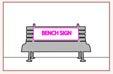
(3) Bench sign. No bench sign may exceed eight feet in width. No bench sign may exceed four feet in height. Only one bench sign may be erected per 50 feet of frontage per lot. No bench sign may be erected within the public right-of-way except with written permission of the City.
(4) Flag sign. Each flag sign may not exceed a sign area of 24 square feet. When measuring sign area for flag signs, the entire fabric area shall be considered the sign area.
(5) Freestanding sign. No freestanding sign may be within 10 feet of any other freestanding sign.
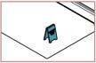
(6) Projecting sign. A projecting sign may extend over the public right-of-way only when authorized by a valid permit. A projecting sign must maintain eight feet of clearance over pedestrian walkways.
(a) A property may display any number of signs, provided that the signs are of a sign type allowed in the district and provided that the aggregate sign area of all signs (in square feet) on the lot does not exceed one-half of the lot’s frontage (in linear feet) or 300 square feet, whichever is less. For example, a lot with 40 feet of frontage may display up to 20 square feet of sign area, distributed over any number of signs.
(b) No individual sign may exceed a sign area (in square feet) equal to the front setback of the sign (in linear feet) or 12 square feet, whichever is more. For example, if a sign has a front setback of 20 feet, it may not exceed 20 square feet in sign area.
(c) No building-mounted sign may exceed a sign height equal to 14 feet plus one-third of the sign’s front setback. For example, if a building-mounted sign has a front setback of 24 feet, it may not exceed 22 feet in sign height.
(d) No freestanding sign may exceed a sign height equal to four feet plus one-third of the sign’s front setback. For example, if a freestanding sign has a front setback of 24 feet, it may not exceed 12 feet in sign height.
(e) A building-mounted sign may not project more than four feet towards the right-of-way. Other signs must be set back at least three feet from the sidewalk edge.
(f) Signs are permitted in districts only as regulated by the Comprehensive Sign Table below.
Are (Sign Type or Feature) Permitted in the (District)?
Are (Sign Type or Feature) Permitted in the (District)?
Signs

Freestanding Signs
Projecting Signs
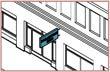
Table 1101.3: Comprehensive Sign Table (Cont’d.). This table sets forth the districts in which each type of sign or sign feature is permitted. Before any permanent sign is erected, moved, altered, or enlarged, it must receive a zoning permit. Temporary signs may be of any type but must adhere to the sign regulations for height and area.
Are (Sign Type or Feature) Permitted in the (District)?
Board Signs
Signs
Signs
Signs
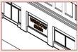
Table 1101.4: Comprehensive Sign Table (Cont’d.). This table sets forth the districts in which each type of sign or sign feature is permitted. Before any permanent sign is erected, moved, altered, or enlarged, it must receive a zoning permit. Temporary signs may be of any type but must adhere to the sign regulations for height and area.
Are (Sign Type or Feature) Permitted in the (District)?


Table 1101.5: Comprehensive Sign Table (Cont’d.). This table sets forth the districts in which each type of sign or sign feature is permitted. Before any permanent sign is erected, moved, altered, or enlarged, it must receive a zoning permit. Temporary signs may be of any type but must adhere to the sign regulations for height and area.
(7) Sandwich board sign. A sandwich board sign may not be located on the public right-of-way unless it is authorized by a valid permit. A sandwich board sign may not be displayed outside of public business hours of the principal use of the lot.
(8) Temporary sign. A temporary sign may not be displayed for more than 180 days within one calendar year.
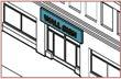
(9) Wall sign. The difference in elevation of the lowest part of a wall sign and the highest part of that wall sign may not exceed 10% of the height of the structure on which it is mounted. The Building Officer may designate a wall sign as a public art mural, which is exempt from these sign regulations.
(10) Window sign. A window sign facing a sidewalk and at an elevation between 3 and 8 feet above sidewalk grade may not exceed 20% of the window area of the window in which it is displayed. Signs displayed in a window, including neon and neon-imitating “open” signs, hours of operation signs, and sale signs are considered window signs, even if not adhered directly to the window.
These sign regulations shall not regulate:
(1) The copy and message of signs;
(2) Official traffic signs, or signs mounted in the public right-of-way by government agencies having jurisdiction within such right-of-way;
(3) A public art mural designated by the Building Officer;
(4) Flags of any nation or government jurisdiction;
(5) Scoreboards on athletic fields;
(6) Gravestones;
(7) The display of street numbers that may aid emergency vehicle’s in locating and responding to an emergency; or
(8) Any display or construction not defined herein as a sign.
(i) Signs Prohibited in All Districts
The following sign types are prohibited in all districts:
(1) Abandoned signs;
(2) Flashing signs;
(3) Hazardous signs;
(4) Inflatable, lighter-than-air, or kite-type materials containing commercial messages;
(5) Merchandise, equipment, products, trailers, or other items not themselves for sale and placed for advertising purposes; this prohibition is not intended to prohibit any form of vehicular signage used in the normal day-to-day operations of a business, such as a sign attached to a bus or lettered on a motor vehicle, unless the primary purpose of such vehicle is for such advertising;
Figure 16: An illustration of a prohibited vehicular sign.

(6) Portable signs;
(7) Roof signs;
(8) Signs within the sight triangle of an intersection;
Figure 17: Illustration of prohibited signs in the sight triangles of an intersection.
(9) Signs within the public right-of-way located on utility or street light poles, utility boxes, or street signs, unless granted permission by the right-of-way authority;
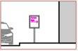
Figure 18: An illustration of a prohibited sign within the public right-of-way located on a street light pole.
(10) Signs resembling traffic signs or traffic control devices on a public street or road; (11) Signs which obstruct ingress or egress of a property; and
Figure 19: An illustration of a prohibited sign obstructing ingress and egress of a property.
(12) Signs with reflective materials, except for those required by the Ohio Department of Transportation.
(a) No fence over six feet in height shall be erected or altered without an approved fence permit, which must clearly be displayed during construction. A fence of six feet or less in height may be erected without a fence permit. Replacement of a fence is permitted without a fence permit, provided materials, height and location do not vary from existing fence and the placement is conforming to the Zoning Code.
(b) Any fence, regardless of height, shall comply with the following standards:
(1) Height
(i) A fence in the front yard shall not exceed four feet in height; a fence in the side yard or rear yard shall not exceed six feet in height.
(ii) Fences that enclose athletic fields and courts are exempt from the six-foot height limit.
(iii) Fences within the Industrial Flex District are exempt from the six-foot height limit provided that they do not exceed 10 feet in height.
(2) Location
(i) Fences are not required to comply with setback requirements applicable to principal or accessory structures. Fences may have setbacks as minimal as zero feet for all lot lines in all districts.
(ii) Only decorative, open fences may be erected within the front yard.
(iii) Fences may not be located so as to encroach upon the required sight triangle area.
(iv) Fences placed on utility easements shall provide access to manholes, utility boxes, cleanouts, or other apparati that may be used from time to time for maintenance of the utility. Fences placed on drainage easements shall allow for the proper flow of water.
(v) Any fence constructed between the required building setback line and street public right-ofway shall not prevent or hinder access to the residence by vehicles and personnel responding to a fire, police, or medical emergency.
(3) Material
(i) No fence shall have barbed wire, concertina wire, razor wire, or any similar material, except that barbed wire is permitted on the top of chain link fences in the Industrial Flex District.
(ii) No fence other than an animal enclosure fence shall have an electrified portion.
(4) Swimming Pool Fences
(i) A swimming pool shall be enclosed by a four-foot-high or higher fence erected wholly on the lot containing the swimming pool. A gap of four inches or more may not exist between the bottom of the fence and the ground surface.
(ii) Solid fences which do not have openings, such as masonry or stone wall, shall not contain indentations or protrusions except for normal construction tolerances and tooled masonry joints.
(iii) Spacing between vertical members of a wood or vinyl fence shall not exceed 1.75 inches in width.
(iv) Maximum mesh size for chain link fences shall not exceed 1.75 inches square unless the fence is provided with slats fastened at the top or bottom which reduce the openings to no more
than 1.75 inches.
(v) In a lattice fence, the maximum opening formed by the diagonal members shall be no more than 1.75 inches.
(vi) Spacing between vertical members of a decorative metal fence shall be no more than four inches and any gate shall have no opening greater than 0.5 inch within 18 inches of the release mechanism.
(vii) Access gates to the pool shall be equipped with a lock operated by a key, or combination lock, and shall be locked when not in use. Pedestrian access gates shall open outward, away from the pool, and shall be self-closing and have a self-latching device. Where the release mechanism of a self-latching device is located less than 4.5 feet from the bottom of the gate: (a) the release mechanism shall be located on the pool side of the gate at least three inches below the top and (b) the gate and fence shall have no opening greater than 0.5 inch within 18 inches of the release mechanism.
(viii) If the sides of a pool are 42 inches or more above the minimum adjacent grade, and the pool is equipped with a removable ladder or a ladder that folds up and locks in an upright position when the pool is not in use, or the steps or ladder is surrounded by a fence as described in this section, then additional fencing will not be required. If an aboveground pool has a fence at the top of the pool, the maximum vertical clearance between the top of the pool and the bottom of the fence shall not exceed four inches.
(ix) A three-foot minimum guardrail conforming to the Residential Code of Ohio is required for any porch, balcony or raised floor surface located more than 30 inches above the floor or grade below, such as elevated pool decks.
(c) Maintenance. Fences shall be maintained in good condition, be structurally sound, safe, and attractively finished at all times. Any repairs or replacement ordered by the Building Officer shall be made within 30 days of the date of the order. Grounds between fences and property lines and between fences shall be well maintained at all times. Any fence shall be designed, constructed and finished so the supporting members thereof shall face the property of the owner of the fence.
(a) In order to protect the public health and environmental quality, no outdoor lighting source may produce light that exceeds a correlated color temperature of 3000 Kelvin between the hours of 10 PM and 6 AM.
(b) All light fixtures shall be required to have cut-off-type shielding so that all light is reflected downwards. Visible light emanating from the top of the fixtures is prohibited. The use of up-lighting to highlight building features may be permitted, provided that the light does not cause glare for pedestrians or vehicles.
(c) All outdoor lighting shall be of constant intensity over time, and shall be directed, reflected or shielded so as not to be of excessive brightness or cause glare hazardous to pedestrians or drivers, create a nuisance, or unreasonably interfere with a neighboring property owner’s right to enjoy their property.
(d) The City is exempt from outdoor lighting standards.
(a) At every corner of every intersection of two streets, a sight triangle shall be established. A sight triangle is the area contained by the right-of-way lines of the two streets and a third line. The third line connects
two points, where each point is distanced from the intersection of the two right-of-way lines by a distance equal to half the average width of the intersecting rights-of-way.
(b) Within a sight triangle, clear visibility between the heights of two feet and ten feet above the average center line grade of the intersection there shall be maintained, except for the trunks of existing trees or light or sign supports.
(c) Trees shall be permitted as long as only the tree trunk is visible between the ground and eight feet above the ground, or otherwise does not present a traffic visibility hazard.
(d) There shall be no vehicle parking or standing space provided within a sight triangle.
(e) No curb cuts or access to parking areas shall be provided within a sight triangle at the intersection of two streets.


Chapter
(a) Nonconformities are lots, structures, or uses that:
(1) Existed at the date of enactment of this Zoning Code, were permitted or otherwise legally allowed under the prior zoning ordinance, and do not comply with the regulations of this Zoning Code; or
(2) Existed at the date of an amendment to this Zoning Code, were permitted or otherwise legally allowed under this Zoning Code prior to such amendment, and do not comply with the regulations of this Zoning Code after the enactment of the amendment.
(b) Regulations are categorized into regulations for nonconforming lots, nonconforming structures, and nonconforming uses, and are set forth in the following sections.
The construction of a conforming structure or the conduct of a permitted use shall be allowed on any nonconforming lot of record which does not comply with the Zoning Code’s minimum lot area or minimum lot frontage standards.
(a) Permitted uses may continue to be conducted in nonconforming structures.
(b) Structures, which by reason of GFA, lot impervious coverage, location on the lot, height, other dimension, appurtenance, or architectural feature are in conflict with the regulations of this Zoning Code, may be altered, reconstructed, or extended only in such manner that the alteration, reconstruction, or extension will not increase the nonconforming area or volume of the structure.
(c) Nonconforming signs are considered nonconforming structures for the purposes of this chapter.
(d) This Zoning Code shall not prevent the necessary maintenance of any part of any nonconforming structure.
(a) The nonconforming use of a lot or a structure may be continued, expanded, or changed only if:
(1) The nonconforming use is changed to a permitted use;
(2) The nonconforming use is changed to a use determined by the Building Officer to be similar in definition and impact as a permitted use; or
(3) The nonconforming use is expanded within an existing structure that it currently occupies and that is manifestly arranged or developed for such use. The Planning and Zoning Code of Portsmouth, Ohio
(b) No nonconforming use may be reestablished where such nonconforming use has been discontinued for a period of six months or longer, except in the case of a calamity, as regulated in this section.
(c) A nonconforming use or uses within any structure damaged by fire, explosion, flood, riot, or act of nature may be continued as prior to such calamity, provided that:
(1) Reconstruction of the structure within which the use was and will be conducted is started within 12 months of such calamity and is continued in a reasonable manner until completion; and
(2) Reconstruction of the structure within which the use was and will be conducted does not result in a larger area dedicated to the nonconforming use than prior to the calamity.
Chapter
Decisions on zoning permit application completion, compliance with regulations, de minimis variances, variances, conditional use approval, zoning map and text amendments, and violations are carried out by the responsible parties as set forth in the Comprehensive Decisions Table below.
Decisions Table
and Zoning Commission City Council County Court of Common Pleas
Table 1101.6: Zoning Code Decisions Chart. This chart assigns roles to the Building Officer, Board of Zoning Appeals, Planning and Zoning Commission, City Council, and the County Court of Common Pleas.
Key: X = Responsible for Application Intake; A = Administrative Decision; QJ = Quasi-Judicial Decision; J = Judicial Decision; QL = Quasi-Legislative Decision; L = Legislative Decision
This chapter sets forth the roles of the Building Officer, the Board of Zoning Appeals, the Commission, and Council in administering the regulations of this Zoning Code and outlines procedures for applying for permits, amending the Zoning Code, and appealing decisions.
(a) Before commencing or proceeding with the erection, construction, enlargement, alteration, repair, or removal of any structure, or any part thereof, or the commencement or change of use or intended use of any lot or structure, a building permit for such structure or use shall first be obtained by the owner, or their agent, or the occupant thereof, from the Building Officer, and it shall be unlawful to commence or proceed with any such work or use unless such building permit has been first obtained.
(b) The City Manager may also require that no building permits or authorizations shall be issued by the Building Officer unless countersigned by another person authorized by the City Manager to do so, stating that the same is being issued in accordance with the provisions of this Zoning Code.
Electronic or hard copies of the building permit application forms may be obtained from the Building Officer.
(a) Applications for building permits shall be filed with the Building Officer.
(b) Building Permit Application Fee. At the time of submission, the applicant must pay a building permit application fee. The fee is determined by the fee schedule established by Council, which shall be furnished by the Building Officer by request.
(c) Components of Building Permit Application. All building permit applications must include a plot plan, drawn to an easily readable scale no smaller than 1 inch:20 ft., showing and labeling by name and dimensions:
(1) The exact location of the lot and/or structure, including street name and street address;
(2) Architectural elevations and cross sections as relevant to the proposed project;
(3) All uses and intended uses of the structure(s) or lot and approximate portions of the structure(s) or lot that are intended to be occupied by each use;
(4) Locations of structures on adjoining parcels;
(5) All existing and proposed property lines;
(6) All existing and proposed easements;
(7) All vehicular use areas, including parking stalls, driveways, service areas, loading areas, and approximate square footage of such areas;
(8) Water outlets and other drainage ways;
(9) Landscape material, including botanical name and common name, installation size, on center planting, dimensions where applicable, and quantities for all plants used; and
(10) A title block with pertinent names and addresses of the property owner(s), contractor, person drawing the plan, applicant, scale, date, north arrow, coordinates, nearest cross-streets, and zoning district.
(a) Compliance with Regulations Determinations
(1) The Building Officer shall examine applications for building permits.
(2) Within 14 calendar days of receipt of the building permit application, the Building Officer shall send an email notification or post-mark a letter to the applicant, notifying the applicant that:
(i) The building permit application is incomplete and requires additional application materials;
(ii) The building permit application is complete but is denied and indicating the rationale for such determination and optionally recommending that the applicant seeks a variance or other remedy;
(iii) The building permit application is complete, and the proposed project complies with the regulations of the Zoning Code, and a building permit is granted;
(iv) The building permit application is complete, and the proposed project nearly complies with regulations of the Zoning Code and, with a de minimis variance, fully complies with the regulations of the Zoning Code, and a building permit is granted;
(v) The building permit application is complete, and the proposed project requires a variance or conditional use approval and may be forwarded to the Board of Zoning Appeals for review; or
(vi) The building permit application is complete, but the project requires a zoning text or map amendment and may be forwarded to the Commission for review.
(3) If a building permit application is denied due to being incomplete or noncompliant with a regulation of the Zoning Code, the applicant may re-submit the building permit application with modifications to the Building Officer. If the applicant re-submits the building permit application within 14 calendar days of receipt of notification of denial, no application submission fee payment will be required in excess of the initial application submission fee, except if the type of application is modified. If the applicant does not resubmit a complete application within 14 calendar days of notification by the Building Officer, the building permit application will not be processed, and the permit application fee will be surrendered to the City.
Upon approval of the application herein provided for and upon the payment of the required fees to the City Auditor, a zoning permit shall be issued to such person or persons to erect such building or structure or to commence a proposed land use on a lot, and the required fees for issuing each and every permit as aforesaid shall be as specified in Chapter 1305 of the Building Code, or as hereafter amended or hereafter required for obtaining a zoning permit.
After any structure has been constructed in accordance with the building permit and the provisions of this Zoning Code, it shall be the duty of the Building Officer to make authorization for occupancy of same,
certifying that the structure has been constructed in accordance with the building permit and Zoning Code and authorizing the installation of utilities and municipal services and the occupancy of such structure.
(a) During the building permit application review process, the Building Officer may approve de minimis variances. A de minimis variance is a deviation of 10% or less of a numerical standard. For example, if a district requires a minimum front setback of 30 feet, a de minimis variance may be approved to reduce the required setback by 10%, or, in this case, 3 feet, to a minimum of 27 feet.
(b) In order to approve a de minimis variance, the Building Officer must determine that the strict application of the Zoning Code would create practical difficulties for the property owner in using the property for its intended purpose(s).
(c) A de minimis variance is valid until the lot or portion of the structure subject to the de minimis variance undergoes a structural alteration.
(a) A building permit application initial submission or re-submission may indicate that a variance is sought for a particular dimensional or non-dimensional regulation of the Zoning Code.
(b) A building permit application seeking a variance should include the following elements:
(1) The nature of the variance, including the specific provisions of the Zoning Code upon which the variance is requested;
(2) A legal description of the property;
(3) A statement of the special circumstances or conditions applying to the land or structure and not applying generally throughout the district;
(4) A statement showing that the special conditions and circumstances do not result from the actions of the applicant;
(5) A statement showing that the granting of the application is necessary to the preservation and enjoyment of substantial property rights;
(6) Such other information regarding the application for variance as may be pertinent or required for appropriate action by the Board of Zoning Appeals;
(7) A list containing the names and mailing addresses of all owners of property within 250 feet of the parcel at issue; and
(8) A fee, as indicated by a fee schedule approved by Council, that covers the cost of mailing notices and other expenses involved in a hearing before the Board of Zoning Appeals.
(c) If such application for variance is made, the Building Officer, during review of the building permit application, shall review all other elements of the zoning permit application. If all other elements of the building permit application are found to be compliant with the regulations of the Zoning Code, the Building Officer shall, within 14 calendar days of receipt of the building permit application initial submission or re-submission, forward the application to the Board of Zoning Appeals with certification of compliance, pending the approval of a variance.
(d) The Board of Zoning Appeals, upon receipt of the application, shall begin the review and hearing procedures as outlined later in this chapter.
(e) A variance, if approved, is valid until the structure that is the subject of the variance is structurally modified or a use is changed, except when the Board of Zoning Appeals prescribes other expiration conditions during its approval of the variance.
(a) If a building permit application proposes the conduct of a use that is listed as a conditionally permitted use in the district in which it is located, it shall include the following elements in addition to the standard requirements of a building permit application:
(1) A statement of the necessity or desirability of the proposed use to the neighborhood or community; and
(2) A statement of the relationship of the proposed use to adjacent property and land use.
(3) A list containing the names and mailing addresses of all owners of property within 250 feet of the parcel at issue.
(b) The Building Officer shall review all other elements of the building permit application. If all other elements of the building permit application are found to be compliant with the regulations of the Zoning Code, the Building Officer shall, within 14 calendar days of receipt of the building permit application, forward the application to the Board of Zoning Appeals with certification of compliance, pending the approval of the conditional use.
(c) The Board of Zoning Appeals, upon receipt of the application, shall begin the review and hearing procedures as outlined later in this chapter.
(a) Collection of Fees. A fee in such amount as may be established by the Council acting by ordinance or resolution shall be paid to the Building Officer for each application for appeal, variance, or conditional use to cover the necessary administrative and advertising costs.
(b) Schedule Public Hearing. Upon receipt from the Building Officer of an application that requires review and hearing by the Board of Zoning Appeals or the Planning and Zoning Commission, the Board or Commission shall schedule a public hearing. Such public hearing shall be no more than 45 calendar days from the date of such receipt.
(c) Public Notice of Public Hearing in Newspaper: The Board or Commission shall provide public notice of the public hearing. The notice shall be published at least 15 calendar days before the public hearing in one or more newspapers of general circulation in the city and set forth the time, place, and general nature of the meeting agenda.
(d) Public Notice of Public Hearing via Post: Public notice shall be provided by the Building Officer via First Class Mail at least 15 calendar days before the public hearing to all property owners of lots within 250 feet of the lot lines of the parcel(s) of concern. Addresses for the property owners shall be acquired by the County Auditor. Failure of delivery of notice does not invalidate said notice. The mailed notices shall include the time, place, and general nature of the public hearing.
(e) Public Hearing
(1) The secretary shall and shall keep records of its examinations and other official actions, all of which shall be immediately filed in the office of the Fiscal Officer, and be a public record.
(2) During the public hearing, each present member of the public may speak at least once per issue to express support or dissent and rationale for such support or dissent.
(3) With permission of the chairperson, a member of the public may speak more than once per issue.
(4) The Board or Commission may pose questions to the applicant, to the Building Officer, or to legal counsel during the public hearing.
(f) Decision Criteria
(1) Variances
Variances are intended to allow the flexibility necessary to adapt to changed or unusual conditions, both foreseen and unforeseen, under circumstances which to not ordinarily involve a change of the principal use of the land or structure permitted. Variances shall not be granted on the grounds of convenience or reduced or greater profit, and evidence of variances granted under similar conditions elsewhere is irrelevant.
(i) Non-numerical variances. In order to grant a variance for a non-numerical standard, the Board must find that the strict application of the Zoning Code would cause the property owner to suffer the loss of all economically viable use of their property. The Board of Zoning Appeals may request that an applicant present a recent and credible appraisal and financial statements to aid in any such determination.
(ii) Numerical variances. In order to grant a variance for a numerical standard, the Board must find that the strict application of the Zoning Code would create practical difficulties for the property owner. Applications for zoning permits that include numerical variance requests shall include evidence that sufficient practical difficulties exist to warrant a variance. The Board, in determining whether the strict application of the Zoning Code would create practical difficulties for the property owner, shall consider:
(a) Whether the property in question will yield a reasonable return or whether there can be any beneficial use of the property without the variance;
(b) Whether the variance is substantial;
(c) Whether the essential character of the neighborhood would be substantially altered or whether adjoining properties would suffer a substantial detriment as a result of the variance;
(d) Whether the variance would adversely affect the delivery of governmental services (e.g., water, sewer, garbage);
(e) Whether the property owner purchased the property with knowledge of the zoning restriction;
(f) Whether the property owner’s predicament feasibly can be obviated through some method other than a variance; and
(g) Whether the spirit and intent behind the zoning requirement would be observed, and whether substantial justice would be done by granting the variance.
(2) Conditional Uses
(i) In order to grant a conditional use approval, the Board of Zoning Appeals shall consider whether the proposed use:
(a) Contributes to the essential character of the neighborhood;
(b) Would likely cause detrimental impact to adjoining properties;
(c) Aligns with the intent of the adopted comprehensive plan and other long-range planning publications; and
(d) May adversely affect the delivery of governmental services (e.g., water, sewer, garbage).
(ii) In order to grant a conditional use approval, the Board of Zoning Appeals must find that:
(a) The proposed use is a conditional use of the district, and the applicable development standards established in the Zoning Code are met;
(b) The proposed development is in accord with appropriate plans for the area; and
(c) The proposed development will be in keeping with the existing land use character and physical development potential of the area.
The members of the Board or Commission shall publicly vote for approval, approval with conditions, or disapproval of the application.
(1) If the Board or Commission votes to approve the application with conditions, the conditions must be intended to be in accord with appropriate plans for the area, and to prevent undesirable effects on adjacent property and the surrounding area. Such conditions may be a limitation on the extent or intensity of development, a requirement for additional screening by fence or landscaping, a change in the method or plan for lighting, control of access or other conditions of development as may be advantageous to the public. Recommendations regarding the modification of plans or other appropriate actions shall be stated with the reasons for each recommendation.
(2) Disapproval of an application must include the reasons for such decision.
(3) For voting to occur, quorum must be reached in the Board of Zoning Appeals or the Commission. If a member abstains from voting on an issue due to conflict of interest or any other reason, that member shall not contribute to the quorum.
(4) If conditions are to be applied to an application approval, the members may, prior to a vote, determine which conditions are to be applied for the intent of clarifying the decision.
(5) A vote for approval, approval with conditions, or disapproval may take place only when a quorum is reached. If a quorum is not reached, the chairperson shall bench the issue and revisit the issue during the next meeting.
(6) The chairperson shall call a vote and the secretary shall keep minutes showing the vote of each member upon each issue or, if absent or failing to vote, indicating such fact.
(7) A decision for approval, approval with conditions, or disapproval shall be established with the vote of a majority of present members. A tie vote shall be interpreted as disapproval.
(h) Delivery of Decision. Within 14 calendar days after the public hearing, the Board of Zoning Appeals or the Commission shall transmit its decision to the Building Officer for recording, except that, in the case of zoning text or map amendments, the Commission shall transmit its decision directly to Council. If the conditional use approval or variance is granted, the Building Officer shall issue the building permit, with the appropriate conditional use approval or variance, to the applicant within 14 calendar days of receipt of decision from the Board of Zoning Appeals or the Commission. Such building permit shall be properly recorded with the County Auditor.
1141.12
Council may change or amend the text of the Zoning Code, or the Zoning Map.
(a) Initiation of Amendment Procedure
(1) Amendment Brought by Council or the Planning and Zoning Commission. Proposed changes or amendments may be initiated by Council by resolution or by motion of the Planning and Zoning Commission.
(2) Amendment Brought by Owner or Lessee of Land. Proposed changes or amendments may be initiated by one or more owners or lessees of land within the area that is proposed to be changed by amendment of the Zoning District Map or by one or more owners or lessees of land to be affected by amendment of other provisions of the Zoning Code.
The application for any proposed change or amendment brought by an owner or lessee of land shall contain:
(i) A description or statement of the present and proposed provisions of the Zoning Code or the proposed change of the district boundaries of the Zoning District Map;
(ii) A description, by map and text, of the property or properties to be affected by the proposed change or amendment;
(iii) A statement of the relation of the proposed change or amendment to the general health, safety, and welfare of the public in terms of need or appropriateness within the area by reason of changed or changing conditions and the relation to appropriate plans for the area; and
(iv) A statement of the relation of the proposed change or amendment to the comprehensive plan.
When making application for an amendment, the investigation and compliance fees, in such amount as may be established by Council from time to time, shall be paid to the City for each application.
(b) Scheduling a Public Hearing at Commission. Upon adoption of a motion by the Planning and Zoning Commission to recommend amendment of the Zoning Code to Council, or upon receipt of notice of a resolution adopted by Council recommending amendment of the Zoning Code, or upon transmittal of a completed application for amendment by the Building Officer, the Planning and Zoning Commission shall schedule a public hearing thereon. Said hearing shall be no more than 30 calendar days from the date of such motion, notice of a resolution, or transmittal of such application.
(c) Notice to the Public via Newspaper for Commission Hearing. Notice of the public hearing shall be in one or more newspapers of general circulation in the city. Said notice shall be published at least 15 calendar days before the date of the public hearing. The published notice shall set forth the time and place of the public hearing and the general nature of the proposed amendments.
(d) Notice to Property Owners via Post for Commission Hearing. If the proposed amendment intends to rezone or redistrict 10 or fewer parcels of land, as listed on the tax duplicate, written notice of the hearing shall be mailed by the Building Officer, by First Class Mail, at least 20 calendar days before the day of the public hearing, to all owners of property within 250 feet of the boundary lines of the area to be rezoned or redistricted to the addresses of such owners as appearing on the County Auditor’s tax list. Failure of delivery of the notifications shall not invalidate any such amendment. The notice shall contain the same information as required of notices published in the newspaper(s).
(e) Public Hearing at Commission
(1) The secretary shall keep records of its examinations and other official actions, all of which shall be immediately filed in the office of the Fiscal Officer, and be a public record.
(2) During the public hearing, each present member of the public may speak at least once per issue to express support or dissent and rationale for such support or dissent.
(3) With permission of the chairperson, a member of the public may speak more than once per issue.
(4) The Commission may pose questions to the applicant, to the Building Officer, or to legal counsel during the public hearing.
(f) Decision Criteria by Commission.
In evaluating whether a zoning text or map amendment is warranted, the Commission shall consider whether the change will:
(1) Better facilitate the implementation of the comprehensive plan’s objectives;
(2) Improve the public health, safety, general welfare, and environmental quality; and
(3) Lead to a more efficient use of government services (e.g., water, sewer, police) or improve financial sustainability.
(g) Making a Commission Decision.
The members of the Commission shall publicly vote to recommend or not recommend the amendment to Council.
(1) The decision to recommend or not recommend an amendment to Council must include reasons for such decision.
(2) For voting to occur, quorum must be reached in the Commission. If a member removes themselves from voting on an issue due to conflict of interest or any other reason, that member shall not contribute to the quorum.
(3) A vote may take place only when a quorum is reached. If a quorum is not reached, the chairperson shall bench the issue and revisit the issue during the next meeting.
(4) The chairperson shall call a vote, and the secretary shall keep minutes showing the vote of each member upon each issue or, if absent or failing to vote, indicating such fact.
(5) A decision to recommend or not recommend the amendment shall be established with the vote of a majority of present members. A tie vote shall be interpreted as not recommending the amendment.
(h) Delivery of Commission Decision to Council.
(1) Within 45 days of the public hearing on the issue, the Planning and Zoning Commission shall transmit its recommendation to the Council. The Planning and Zoning Commission may recommend that the amendment be granted as requested, or it may recommend a modification of the amendment as requested, or it may recommend that the amendment be denied.
(i) Scheduling a Public Hearing at Council. Upon receipt of the recommendation from the Planning and Zoning Commission, Council shall schedule a public hearing therein. Said hearing shall be no more than 60 calendar days from the receipt of the recommendation from the Planning and Zoning Commission.
(j) Notice to the Public via Newspaper for Council Hearing. Notice of the public hearing shall be given by at least one publication in one or more newspapers of general circulation in the City. Said notice shall be published at least 30 calendar days before the date of the required Council hearing. The published notice shall set forth the time and place of the public hearing and the general nature of the proposed amendments. During such 30 days, the text or copy of the text of such ordinance, measure, or regulation, together with the maps or plans or copies thereof forming part of or referred to in such ordinance, measure or regulation, and the maps, plans, and reports submitted by the Planning and Zoning Commission, Board of Zoning Appeals, or Building Officer shall be on file, for public examination, in the office of the Fiscal Officer or in such other office as is designated by Council.
(k) Notice to the Public via Newspaper for Council Hearing. If the proposed amendment intends to rezone or redistrict 10 or fewer parcels of land, as listed on the tax duplicate, written notice of the hearing shall be mailed by the Fiscal Officer, by First Class Mail, at least 20 calendar days before the day of the public
hearing to all owners of property within 250 feet of the boundary of the area to be rezoned or redistricted to the addresses of such owners appearing on the County Auditor’s tax list. Failure of delivery of the notifications shall not invalidate any such amendment. The notice shall contain the same information as required of notices published in the newspaper(s).
(l) Making a Decision. No ordinance, measure, or regulation which violates, differs from, or departs from the plan or report submitted by the Planning and Zoning Commission shall take effect unless passed or approved by not less than three-fourths of the members of Council.
No ordinance, measure, or regulation which is in accordance with the recommendations, plans, or report submitted by the Planning and Zoning Commission shall be deemed to pass or take effect without the concurrence of at least the majority of the members of Council.
(a) When a lot is annexed by the city, its zoning classification shall be determined during a public hearing by the Commission within 45 days of the annexation.
(b) Within 7 calendar days after the determination by the Commission, the official zoning map and its online version shall be updated to indicate such determination.
(c) If a building permit application is received for a property within the annexed area before such zoning classification is determined by the Commission, the Building Officer shall evaluate the proposed development and determine its conformity with the character, scale, and use of the existing development in the neighborhood. If the proposed development is determined to be in conformity with the character, scale and use of the existing development in the neighborhood and all other requirements of the Zoning Code are met, a building permit shall be issued by the Building Officer. If the proposed development is not in conformity with the character, scale, and use, of the existing development in the neighborhood, a building permit shall not be issued. If the Building Officer is not able to definitively determine the character, scale, and use of the existing development in the neighborhood, they shall apply the standards of the Hillside Neighborhood District.
(a) Appeals to the Board of Zoning Appeals may be taken by any person aggrieved, or by any officer of the City affected by any decision of the Building Officer. Appeals from decisions made by the Board of Zoning Appeals may be taken to the County Court of Common Pleas. No appeals from zoning text or map amendment decisions may be made.
(b) Appeals to the Board of Zoning Appeals shall be taken within 20 calendar days after the decision by filing an appeal with the Building Officer and specifying the grounds for the appeal. The Building Officer shall transmit to the Board of Zoning Appeals all the papers constituting the record upon which the action was taken.
(c) In exercising appeal powers, the Board of Zoning Appeals may reverse or affirm, wholly or partly, or modify the order, requirement, decision, or determination appealed from and may make such order, requirement, decision, or determination as ought to be made, and to that end has all powers of the Building Officer from whom the appeal is taken.
The following regulations apply only if a Board of Zoning Appeals is established and maintained by the City. If a Board of Zoning Appeals is not established or maintained by the City, its typical roles and duties shall be administered by the Commission.
(a) The Board of Zoning Appeals shall consist of five members, to be appointed by Council.
(b) One member shall be the President of Council. This member shall be a voting member of the Board of Zoning Appeals.
(c) The other four members shall be citizens of the city, not in the service of the City, and shall serve without compensation. These members’ terms shall be four years and shall be so arranged that the term of one member will expire each year. Each member shall serve until their successor is appointed and qualified.
(d) Members of the Board of Zoning Appeals shall be removable for nonperformance of duty, misconduct in office, or other cause by Council upon written charges having been filed with Council and after a public hearing has been held regarding such charges, a copy of the charges having been served upon the member so charged at least ten days prior to the hearing, either personally, or by registered mail, or by leaving the same at their usual place of residence. The member shall be given an opportunity to be heard and answer such charges.
(e) Vacancies shall be filled by Council and shall be for the unexpired term.
(f) Organization and Meetings
(1) All meetings of the Board of Zoning Appeals shall be open to the public.
(2) Hearings of the Board shall be preceded by a notice published not less than six days in advance of such hearing, as provided in Section 123.03 of the Administrative Code.
(3) Quorum shall be three members voting on an issue. If a member removes themselves from voting on an issue due to conflict of interest or any other reason, that member shall not contribute to the quorum.
(4) A vote for approval, approval with conditions, or disapproval may succeed only when a quorum is reached and only with such vote of a majority of present members. A tie vote shall be considered disapproval.
(5) Meetings of the Board shall be held at the call of the chairperson, and at such other times as the Board determines.
(6) The chairperson, or in their absence the acting chairperson, may administer oaths, and the Board of Zoning Appeals may compel the attendance of witnesses.
(7) The Board of Zoning Appeals shall keep minutes of its proceedings, showing the vote of each member upon each question or, if absent or failing to vote, indicating such fact, and shall keep records of its examinations and other official actions, all of which shall be immediately filed in the office of the Fiscal Officer, and be a public record.
1141.16
Pursuant to Ohio Revised Code Section 713.01, et seq., and the City of Portsmouth Charter Sections 114-124, a Planning and Zoning Commission is hereby created and established.
The powers and duties of the Commission shall be those granted or imposed by Ohio Revised Code 713.01 to 713.27, 735.17 to 735.26, 735.15, and all other sections of the Ohio Revised Code, those provided by this Zoning Code, such as are otherwise provided by ordinances passed by Council relating to the Planning and
Zoning Commission, and the following:
(a) Review of preliminary and final plats and recommendation of action of Council;
(b) Approval of variances to the Subdivision Regulations;
(c) Initiate and review amendments to the Zoning Map and to the Zoning Code and recommendation of action to Council;
(d) Initiate rezoning applications;
(e) Initiate the inclusion of annexed territory in one or more of the zoning districts defined in the Zoning Code as amended;
(f) Review and approve final development plans, and review and approve amended and revised development plans;
(g) Review and approve site development plans;
(h) Initiate planning activities within the City including comprehensive planning, land use planning, park and recreation planning, and all other types of planning activities as may be appropriate; and
(i) Hear and determine appeals provided by the Subdivision Regulations and Zoning Code.
If a building permit application or zoning text or map amendment proposal is denied by the Building Officer, the Board of Zoning Appeals, or the Planning Commission, a building permit application or zoning text or map amendment proposal of exact likeness may not be resubmitted within a period of one year from the date of disapproval.
When a building permit has been issued, the operation called for by it shall be for a term of one year from its date, and at the expiration of such period, a new building permit shall be obtained in the same manner as provided for the original building permit, before such work can proceed further.
A conditional use approval expires after one year if the subject of the conditional use approval, such as the use of a lot as a school or the erection of the structure needed to conduct such use, has not been initiated.
A variance approval expires after one year if the subject of the variance, such as the erection of a structure within the minimum required front setback, has not been initiated.
A variance is valid until the lot, structure, or use that is the subject of the variance undergoes significant modification that alters the element that was the subject to the variance, except when the Board of Zoning Appeals establishes other expiration conditions during its approval of the variance.
(a) Any resident or employee of the City may report violations of this Chapter to the Building Officer for appropriate actions.
(b) When any premises is in violation of this Chapter, the Building Officer or their designee shall issue a notice of violation to the owner, lessee, agent or tenant of the owner having charge of the premises, by certified mail, return receipt requested, or by personal service by a City employee designated by the Building Officer to perform such service. This notice of violation shall specify the violation committed and contain an order to conform to this Zoning Code within a certain number of days, not to exceed 180 days. In the event that weather or other unforeseen circumstances prevents correcting or abating the violation, the Building Officer may extend the time set forth herein.
(c) Each day any such violation continues after receipt of a violation notice and after the term allotted for remediation of the violation on the citation has expired shall constitute a distinct and separate offense. The owner or tenant of any building, structure, premises, or part thereof, and any architect, builder, contractor, agent or other person who commits, participates in, assists in, or maintains, such violation, may each be found guilty of a separate offense and suffer the penalties herein provided.
It shall be the duty of the person designated or appointed as the Building Officer to enforce this Zoning Code by the granting or refusal of building permits and occupancy authorizations and in accordance with the provisions of this Zoning Code.
Violations of this Zoning Code are subject to penalties, as described below.
The owner or owners or the occupant or occupants of any structure or lot, or any part thereof, which is being created, erected, constructed, reconstructed, enlarged, altered, repaired, or used in violation of the terms hereof, including building permit and/or occupancy permit requirements, and any architect, building, plumber, carpenter, mason or workman who may be employed or assists in the commission of any such violations, and all other persons or corporations who violate the provisions hereof, including building permit and/or occupancy permit requirements, or fail to comply therewith or with any requirement thereof, shall, for each and every violation or noncompliance, be fined an amount established by Council.
Glossa ry
Chapter
Access Sign. A freestanding or building-mounted sign that is located within 10 feet of the street right-of-way and within 10 feet of a curb cut or other vehicular accessway to a lot.
Accessory Structure. A subordinate structure, the use of which is incidental to and customarily associated with the principal structure’s use and which is located on the same lot or adjacent lot as the principal structure and principal use.
Accessory Use. A subordinate use which is incidental to and customarily associated with the principal use and which is conducted on the same lot or adjacent lot as the principal use.
Addiction Treatment Facility. Any building, structure, or space whose principal or primary function is the reception, and/or care of chemically dependent adults and/or their minor children, and/or by which distribution of synthetic narcotics or any other method attempts to control, suppress, and/or eliminate a person’s mental or physical dependence on any illegal or harmful substance.
Adult Book Store. An establishment having as a substantial or significant portion of its stock in trade, books, magazines, and other periodicals which are distinguished or characterized by their emphasis on matter depicting or relating to “specified sexual activities” or “specified anatomical areas” as herein defined or an establishment with a segment or section devoted to the sale or display of such material.
Adult Mini Motion Picture Theater. A facility with a capacity for less than 50 persons, used for presenting material distinguished or characterized by an emphasis on matter depicting, describing or relating to “specified sexual activities” or relating to “specified anatomical areas” for observation by patrons therein.
Adult Motion Picture Theater. A facility with a capacity of 50 or more persons used for presenting material distinguished or characterized by an emphasis on matter depicting, describing or relating to “specified sexual activities” or “specified anatomical areas” for observation by patrons therein.
Adult Entertainment Business. Any establishment involved in the sale or services of products characterized by the exposure or presentation of “specified anatomical areas” or physical contact of live males or females, and which is characterized by salacious conduct appealing to prurient interest for the observation or participation in by patrons. Services or products included within the scope of adult entertainment business are photography, dancing, reading, massage and similar functions which utilize activities as specified above.
Adult Use. A principal use involving the sale of adult goods or services. Adult uses consist of adult entertainment businesses, such as adult book stores, adult mini motion picture theaters, and adult motion picture theaters.
Agent. An authorized representative of an applicant.
Agriculture. See the definition of agricultural activities in the Ohio Revised Code, Section 1.61, excluding Large and Major Farms. Agriculture also includes agritourism uses, as defined by the Ohio Revised Code, Section 901.80.
Air Transport Services. A principal use consisting of the use of aircraft to transport goods or persons. Air transport services include airports. Airport designers and administrators and logistics brokers are considered professional services uses.
Alley or Alleyway. A public or private right-of-way of a width of 20 feet or less, which provides secondary access to property(s) abutting such alley.
Alteration. Any action that changes the height, size, or shape of a structure or any action that affects the structural supports of a sign.
Animal Care. A principal use, other than agriculture, consisting of the housing, training, exercising, and/or providing medical services for large and small animals, including any outside runs, kennels, or training areas.
Animated Sign. Any attention-diverting apparatus, equipment or devices in a sign that uses movement or change of lighting to depict action or create a special effect or scene. Animated signs shall include: blinking, coursing, flashing, moving, racer-type, rotating, revolving, spinning, and other similar types of apparatus, equipment or devices. (See “electronic message” and “flashing” signs.)
Antenna. Any transmitting or receiving device used in communications that radiate or capture electromagnetic waves, digital signals, analog signals, radio frequencies, wireless communications signals, or other communication signals.
Antenna Support Structure. Any building or structure other than a tower which can be used for the location of wireless communications facilities.
Appeal. A request for review of the interpretation of the Building Officer or their designee or the Planning Commission of any provision of this Zoning Code.
Applicant. The owner or authorized representative of a lot that is requesting a permit, variance, or other permission from the City.
Architect. An architect registered by the State of Ohio.
Arterial Street. A street that accommodates traffic to and from an expressway or to or through major commercial districts and that generally experiences traffic volumes exceeding 10,000 ADT.
Artisan Manufacturing. The preparation, display, and/or sale of individually crafted products, such as artwork, jewelry, furniture, sculpture, pottery, leathercraft, hand-woven articles, food products and related items in an establishment not exceeding 3,000 square feet of GFA per lot.
Arts, Science, and Cultural. A principal use consisting involving the advancement of art, science, or culture and the delivery of art, science, or culture to the general public, such as museums, ballets, and theaters. Arts, science, and cultural uses do not have a central mission to sell products or services for profit and do not, therefore, include art vendors, for-profit fabrication studios, or dance lesson studios that are not in association with a not-for-profit dance company.
Automotive Sales. A principal use consisting of the selling or leasing of personal vehicles, including cars, light trucks and SUVs, motorcycles, RVs, ATVs, motorized recreational equipment, and motorized watercraft, new and used.
Automotive Services. A principal use consisting of the commercial care of personal automobiles and light trucks, including repair, cleaning, maintenance, and refueling. Deliveries of parts and towing of vehicles may occur daily, but heavy truck traffic is infrequent and typically limited to refueling and delivery of fuel. Facilities for heavy truck repair are considered commercial services uses.
Average Grade. The lower of:
(a) Existing grade prior to construction; or
(b) The newly established grade after construction, exclusive of any filling, berming, mounding, or excavating solely for the purpose of locating or increasing the height of a sign or fence.
Awning. A permanent roof-like cover, often of fabric, metal, or glass, which projects from a wall or roof of a structure over a window, walkway, doorway, or the like and is designed and intended for protection from the weather or as a decorative embellishment. An awning is not differentiated from a canopy.
Awning Sign. A sign located on an awning.
B.
Basement. A story having more than one-half of its height below the average grade.
Bench Sign. A sign located on the seat or back of a bench placed on or adjacent to a public right-of-way.
Block. All or part of one side of a street between two intersecting streets.
Board. See Board of Zoning Appeals.
Board of Zoning Appeals. The Board of Zoning Appeals of Portsmouth, Ohio, or, if a board of zoning appeals is not active in the city, the Planning and Zoning Commission of Portsmouth, Ohio.
Bond. Any form of security, including cash deposit, surety bond, collateral, property, or instrument of credit, in an amount and form satisfactory to Council.
Buffer. An undeveloped easement area that lies at the periphery of a lot and insulates the negative effects of one property from impacting a neighboring property or district.
Building. Any structure with substantial walls and roof securely affixed to the land, and which is entirely separated on all sides from any similar structure by space or by walls in which there are no communicating doors, windows, or similar openings.
Building Officer. The staff person or their designee responsible for the administration and enforcement of the Zoning Code for the City.
C. Canopy. See Awning.
Cemetery. Land used or intended to be used for the burial of the dead and dedicated for cemetery purposes including mausoleums, but excluding crematoriums and funeral establishments. Depending on the size of the use, a cemetery is considered either a Medium Outdoor Recreation or a Small Outdoor Recreation use.
Certificate of Deposit. A certificate held on deposit by a financial institution for the City under such time as a subdivider has fulfilled their obligation to install any required improvements.
City. Of or relating to the City of Portsmouth, Ohio, and its administration.
City Administrator. The staff administrator of municipal operations for the City.
Commercial Sales. A principal use consisting of the sale or leasing of goods to other businesses rather than directly to household consumers. Examples of commercial sales include the selling of raw materials, equipment, office furniture, and commercial vehicles.
Commercial Services. A principal use that provides services to other companies rather than directly to household consumers. These services typically involve the arrival and departure of heavy trucks more than once per day. Examples of commercial services are farm equipment rental services, machinery repair services, and commercial linen laundering. A crematorium is considered a commercial services use.
Commission. See Planning and Zoning Commission.
Comprehensive Plan. A central organizing document for planning and managing growth.
Connection. A sidewalk and/or bike path that links neighborhoods to other neighborhoods, schools, parks, and other destinations.
Conservation Area. An area designated by the Planning and Zoning Commission, the current comprehensive plan, or another officially adopted planning document as an area where development should not occur due to the area’s environmental, aesthetic, social, or cultural significance to the City.
Conservation Easement. A nonpossessory interest in real property imposing limitations or affirmative obligations, the purposes of which include retaining or protecting agricultural, natural, scenic, or open space values of real property; protecting natural resources; or maintaining air or water quality.
Conservation Recreation. A principal use that preserves natural habitat or recreates natural communities in outdoor settings. Associated educational interpretation, trails, and shelters are included in conservation recreation uses. Examples of conservation recreation uses include arboreta, preserves, scenic river corridors, and hiking areas.
Construction Plans. The maps or drawings accompanying a subdivision plat and showing the specific location and design of improvements to be installed in a subdivision.
Cooperative Dwelling. A type of residential use, differentiated from dwelling, as defined in the City of Portsmouth Housing Code. If no definition is provided in the City of Portsmouth Housing Code, a cooperative dwelling shall be defined as: a structure that is arranged, designed and intended to house multiple individual residents, and not a single-family or multiple-families, with shared kitchen and bathroom facilities and a shared living space; each resident has access to their own sleeping room and the number of occupants shall not exceed provisions set forth in the City of Portsmouth Housing Code.
Corner Lot. A lot abutting upon two or more streets at their intersections, or upon two parts of the same street, and in either case forming an interior angle of 135 degrees or less as measured at the center line of the road or the interior right-of-way line as applicable.
Council. The legislature of the City.
Crematorium. A use containing properly installed, certified apparatus intended for use in the act of cremation. A crematorium is considered a commercial services use.
Development. Construction, reconstruction, conversion, structural alteration, relocation or enlargement of any structure; the construction, expansion or modification of any parking areas, loading areas, access drives or other paved surfaces; any mining, excavation, landfill or other modification of the natural landscape; any changes to approved landscape plans including plant materials, grading, walls, or fences.
District. A distinct geographic area of the municipality wherein regulations of the Zoning Code are uniformly applied. For the purposes of this Zoning Code, the term district is used synonymously with the term zone.
Double-frontage Lot. A lot with frontage on more than one street. Double-frontage lots include corner
lots and through-lots.
Driveway. Any unenclosed motor vehicle pathway that (a) does not exceed 10 feet in width or the width of the garage to which it leads, whichever is greater, and (b) in the shortest distance practicable, provides a vehicular path from a street right-of-way to a private garage or to an area to the side or rear of the principal structure.
Dwelling. A structure or part of a structure that is used as a home, residence, or sleeping place by one person who maintains a household or by two or more persons who maintain a common household. A cooperative dwelling is differentiated from a dwelling; see the definition of a cooperative dwelling.
Dwelling Unit. A room or group of rooms occupied as separate living quarters or, if vacant, intended for occupancy as separate living quarters. Separate living quarters are those in which the occupants live and eat separately from any other persons in the building and which have direct access from outside the building or through a common hall.
Earth-disturbing Activity. Actions taken to alter the existing vegetation and/or underlying soil of site, such as clearing, grading, site preparation (e.g., excavating, cutting, and filling), soil compaction, and movement and stockpiling of top soils.
Easement. The right to use the real property of another owner for a specific purpose. The easement is itself a real property interest, but legal title to the underlying land is retained by the original owner for all other purposes.
Electronic Message Sign. A sign with a fixed or changing display or message, wherein the sequence of message and the rate of change is electronically programmed and can be modified by electronic process.
Emergency Medical Care. A principal use consisting of services provided by medical personnel that include emergency room care, trauma care, or overnight care. Emergency ambulance services may frequently visit emergency medical care uses.
Engineer. The staff engineer of the City.
Environmental Impact Statement. A detailed analysis of the environmental consequences of a project or proposed action as required by the U.S. Environmental Protection Agency or the Ohio Environmental Protection Agency.
Equipment Shelter or Equipment Cabinet. The structure in which the electronic receiving and relay equipment or other necessary equipment for a wireless communications facility is located.
Escrow. A deposit of cash with the City in lieu of an amount required and still in force on a performance or maintenance bond.
Excavation. The removal or recovery by any means of soil, rock, mineral substances, or organic substances other than vegetation, from on or beneath the surface of water or land.
External Illumination. A sign illumination technique that uses light sources outside of the sign face that project light towards or across the sign face. An example of external illumination is gooseneck lighting.
F.
Family Care Services. A principal use that provides human services related to child day care, adult day care,
or funeral services, and where customers are not overnight residents of the property. Funeral homes are considered family care services, except when crematory services are provided, in which case the funeral home is considered a commercial services use. Addiction treatment facilities are not considered family care services.
FCC. The U.S. Federal Communications Commission and any legally appointed, designated, or elected agent or successor.
FEMA. Federal Emergency Management Agency; the agency with the overall responsibility for administering the National Flood Insurance Program.
Fence. A constructed barrier of wood, masonry, stone, wire, metal, or other manufactured material or combination of materials erected to enclose, screen, or otherwise separate areas of land, including agricultural fences.
Flag. A fabric, banner, or bunting containing distinctive colors, patterns or symbols, used as a symbol of a recognized government or political subdivision, corporation, lodge, fraternity or sorority, political party, nonprofit organization, charity, club, association or other similar entity.
Flag Sign. A flag that conveys a message other than representing a recognized government or political subdivision.
Flashing Sign. A sign, the illumination of which is not constant in intensity when in use, and which exhibits sudden or marked changes in lighting effects.
Footprint. The outline of the total area covered by a structure or paved area’s perimeter at the ground’s surface.
Freestanding Sign. A sign that is attached to, erected on, or supported by some structure, such as a post, mast, or frame that is not itself an integral part of or attached to a building or other structure whose principal function is something other than support of a sign.
Frontage. That portion of a lot abutting on a dedicated street right-of-way.
Front Lot Line. A lot line that separates a lot from a street right-of-way.
Front Setback. The shortest horizontal distance between the front lot line and any portion of a structure on the lot.
Figure 22: An illustration of the front setback of a corner lot (with streets to the left and bottom of the illustration).
Front Setback Line, Minimum. A line formed by connecting points, where each point is internal to the lot and distanced from the front lot line by the minimum required front setback.
Figure 23: An illustration of the minimum front setback lines of a corner lot (with streets to the left and bottom of the illustration).
Front Yard. Any undeveloped area of a lot that has a setback from the front lot line equal to or less than X, where X equals the distance between a front lot line and the most distant point of a front facing exterior wall of a principal structure, measured perpendicularly from the front lot line. For this definition, a front facing exterior wall is any wall that is within 60 degrees of parallel of a front lot line.
Funeral Home. A principal use consisting of undertaking services, such as preparing the dead for burial, and arranging and managing funerals. Typical uses include funeral homes or mortuaries. Funeral homes are considered family care services, except when crematory services are provided, in which case the funeral home is considered a commercial services use.
General Personal Services. A principal use that provides services for a person’s everyday functions in spaces of less than 3,000 square feet of floor area. These services include salons, spas, laundromats, dry cleaners, shoe repair, physical fitness centers, and dance studios, martial arts studios, art education centers, and electronics repair. Heavy truck shipments to the location of general personal services uses are infrequent.
GFA. Gross floor area, or the total number of square feet of floor area within the outside line of walls and including the total of all space on all floors of a building, including porches and garages, but not including space in a basement or cellar when the basement or cellar space is used only for storage or incidental uses, and not including floor space with less than 78 inches of vertical clearance.
Government Administration. A principal use that provides office space, hearing chambers, waiting rooms, and other facilities for administering government responsibilities, such as legal services, planning services, resource protection administration, education programming administration, and emergency management services, but not including police and fire stations.
Government Services. A principal use consisting of government service distribution, such as road salt storage, animal rescue centers, correctional facilities, vehicle maintenance and storage, police stations, fire stations, and emergency medical services dispatch stations, and their associated garages, offices, grounds, boarding halls, and sleeping facilities. Government services do not include schools.
Grade The slope of any surface, specified in percent grade terms, where percent grade is the ratio of vertical elevation change over horizontal distance multiplied by 100. Grade may also mean Average Grade.
Ground Level. See Street Level.
Ground Transport Services. A principal use involving the use of trains, trucks, or buses to transport goods or persons. Ground transport services include truck depots, train stations, and bus stations, but not taxi depots or car rental centers. Ground transport services do not include the storage of goods to be transported and, therefore, do not include warehouses, which are considered light industrial uses.
Hazardous Sign. Any sign or sign support structure that is structurally or electrically unsafe, as determined by the City.
Heavy Industrial. A principal use consisting of an establishment engaged in manufacturing, assembly, fabrication, packaging, or other industrial processing of products primarily from extracted or raw materials or the bulk storage and handling of such products and materials, or an industrial establishment having potential to produce noise, dust, glare, odors or vibration beyond its property line. This term includes but is not limited to: (a) processing and packaging; (b) chemical manufacturing; (c) stonework or concrete product manufacturing; (d) fabrication of metal products; (e) manufacturing of agricultural, construction, or mining machinery; (f) motor vehicle manufacturing; (g) lumber milling; (h) ship or boat construction (i) permanent concrete/batch plant.
Home Occupation. An accessory use of a dwelling unit for legitimate businesses, professions, trades or vocations conducted within an enclosed dwelling unit, which is clearly incidental and accessory to residential occupancy and does not change the residential character thereof.
I.
Impervious Coverage. The percent of the lot’s horizontal plane that is occupied by impervious, man-made materials, including, but not limited to, buildings, asphalt, concrete, swimming pools, barns, and carports, but
excluding porous pavement, permeable pavers, decks with gaps between decking for drainage, lawn grasses, gardens, and other landscaping.
Indoor Recreation or Leisure. A principal use that includes indoor leisure and recreation uses of more than 3,000 square feet but smaller than 50,000 square feet, such as skating rinks, gymnastics studios, dance studios, boxing clubs, bowling alleys, large physical fitness centers, and cinemas. Indoor recreation or leisure uses also include organization and membership club centers that are meeting areas for the membership of fraternal organizations, political organizations, and business organizations. Up to 50% of the floor area of an indoor recreation or leisure use may be used as the offices of administrators associated with the use. Physical fitness centers smaller than 3,000 square feet are categorized as general personal services uses.
Interior Lot. A lot that has only one street frontage.
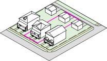
25: An illustration of the lot lines of an interior lot.
Internal Illumination. A sign illumination technique involving a light source that is located either in the interior of the sign so that the rays go through the face of the sign or the sign’s letters or symbols, or which is attached to the face of the sign and is perceived as a design element of the sign.

Irregular Lot. A lot that is not rectangular.

K.
None.
L.
Landscape Architect. A landscape architect registered by the State of Ohio.
Large Light Industrial. A principal use consisting of an establishment engaged in the indoor warehousing, manufacturing, assembly, fabrication, packaging or other industrial processing of finished parts or products, primarily from previously prepared materials, or the indoor provision of industrial services, where there are few external effects across property lines. This term includes but is not limited to a business engaged in the processing, fabrication, assembly, treatment, or packaging of food, textile, leather, wood, paper, chemical, plastic, or metal products, but does not include basic industrial processing from raw materials. Large light industrial uses have principal structures of 25,000 square feet or more per lot. Renewable energy generation systems with 25,000 square feet of structure or more per lot are considered large light industrial uses.
Large Lodging. A principal use involving a building or a part of a building in which guest rooms are offered for public hire to any individual(s) for no more than 35 days in a calendar year, and where a general kitchen and dining room may be provided within the building or in any accessory building. A large lodging is differentiated from a small lodging use in that a large lodging use exceeds 5,000 square feet of GFA per lot or has more than 8 guest rooms per lot.
Large Outdoor Recreation. A principal use that attracts large volumes of visitors in an outdoor setting, has an occupancy capacity of more than 20,000 persons, and may induce high volumes of traffic, light, and/or noise. Examples of large outdoor recreation uses include commercial water parks, regional amusement parks, professional or collegiate sports venues, and outdoor music venues.
Large Retail. A principal use consisting of the selling or leasing of goods directly to household consumers in retail spaces exceeding 5,000 sq. ft. of GFA per lot. For the purposes of calculating GFA for this definition, retail units in attached structures that straddle lot lines and under common ownership or management shall be calculated as being located on the same lot. Large retail includes, but is not limited to, the selling or leasing of clothing, unprepared food, home goods and furnishings, collectibles and antiques, electronics, non-motorized recreation equipment, art and décor, pets and pet care products, and appliances.
Large Surface Parking. A principal or accessory use consisting of an off-street, ground-level area improved for the temporary storage of motor vehicles and in excess of 5,000 square feet per lot.
Library. A principal use consisting of a public, nonprofit facility in which literary, musical, artistic, or reference materials such as but not limited to books, manuscripts, computers, recordings, or films are kept for use by or loaning to patrons of the facility, but are not normally offered for sale.
Litter. Garbage, trash, waste, rubbish, ashes, cans, bottles, wire, paper, cartons, boxes, automobile parts, furniture, glass or anything else of an unsightly or unsanitary nature.
Local Street. A street intended to provide access to other streets from individual properties, generally bearing a volume of traffic no greater than 800 ADT.
Lot. A tract, plat, or portion of a subdivision or other parcel of land intended as a unit for the purpose, whether immediate or future, of transfer of ownership or for a building development.
Lot Frontage. The aggregate length of all front lot lines.
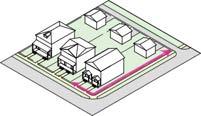
Lot Line. The bounding line that separates a lot from another lot or from a right-of-way.
Major Collector Street. A street which carries traffic from the minor collector system to an arterial street and that generally experiences traffic volumes of less than 10,000 ADT.
Manufactured Home. A generic term that describes housing that is manufactured in a factory rather than on-site according to the Manufactured Home Construction and Safety Standards (HUD Code).
Mayor. The mayor of the City.
Medium Outdoor Recreation. A principal use that provides opportunities to play and relax on lots larger than two acres or with more than eight parking spaces but with occupancy capacities of fewer than 20,000 persons. Such uses may include disc golf courses, golf courses, non-professional and non-collegiate sports fields, regional beaches, large pools, and sledding hills. Cemeteries of more than two acres are considered medium outdoor recreation uses.
Menu Board Sign. A ground-mounted sign displaying the bill of fare for a restaurant, drive-in or drive-thru restaurant, or instructions or services for other drive-thru establishments.
Minor Collector Street. A street that carries internal traffic within a neighborhood, connects local streets to major collector streets or to arterial streets and that generally experiences traffic volumes of less than 4,000 ADT.
Minor Subdivision. Any subdivision involving no more than five lots after the original tract has been completely subdivided, all of the lots of which front on an existing street and with which there is no new street or right-of-way required or proposed.
Mobile Home. A structure, transportable in one or more sections, which is at least eight feet in width and 32 feet in length, which is built on a permanent chassis and designed to be used as a dwelling unit, with or without a permanent foundation when connected to the required facilities.
Mobile Sign. A sign attached to, mounted to, pasted, painted or drawn on any vehicle, whether motorized or pulled, that is placed, parked or maintained at one particular location for the express purpose and intent of promotion or conveying an advertising message.
Monopole. A support structure constructed of a single, self-supporting hollow metal tube securely anchored to a foundation.
Neighborhood Agriculture. A use involving agricultural activities, as defined by the Ohio Revised Code Section 1.61, provided that the activities are limited to one acre per lot.
ODOT. The Ohio Department of Transportation.
OEPA. The Ohio Environmental Protection Agency.
Open Space. Land reserved from development as a relief from the effects of urbanization. It is often intended to be used for passive recreation purposes, but it may also include pedestrian plazas or active recreation areas.
Outdoor Storage. The storage of any material for a period greater than 24 hours, including items for sale, lease, processing, and repair (including vehicles) not in an enclosed building.
P.
Parking Area. Any all-weather, dustless surface used or intended to be used for the temporary storage of a motor vehicle.
Parking Space. The area required for parking one automobile, not including drive aisles.
Permanent Foundation. (1) A full, poured concrete or masonry foundation; (2) a poured concrete frost wall or a mortared masonry frost wall, with or without a concrete floor; (3) a floating slab for which the municipality may require an engineer’s certification if it is to be placed on soil with high frost susceptibility; and (4) any foundation which, pursuant to the building code of the municipality, is permitted for other types of dwellings.
Permanent Sign. A sign affixed to a structure or embedded in the ground whose principal supporting structure is intended, by design and construction, to be used on a permanent basis.
Pick-up Window. An opening in a building, including windows, doors, chutes, or mechanical devices, through which occupants of a motor vehicle or persons on foot are passed or otherwise receive or obtain a product or service.
Planning and Zoning Commission. The Planning and Zoning Commission of the City.
Pole Sign. A permanent freestanding sign that is mounted on one or more poles or other support so that the bottom edge of the sign face is six feet or more above the grade.
Principal Structure. A building or other structure that is designed for or occupied by a principal use.
Principal Use. A use that is the primary function of land or structure(s) on a lot.
Private Street. A privately owned strip of land providing access to abutting properties, but not a driveway.
Professional Services. A principal use involving professional activities in an office setting, where shipments from heavy trucks are rare, the majority of the persons on site are employees, and work schedules are typically day-time. Professional services do not include the storage, processing, testing, or production of materials that
may pose a threat to nearby residential or commercial uses, such as materials that are carcinogenic, flammable, explosive, or unstable, other than those in quantities customarily found in personal computing equipment and office settings. Professional services include, but are not limited to, financial services, such as insurance and banking firms, realtors, travel agents, engineers, pet trainers, and consultants. Professional services also include medical office services but not those that provide emergency medical care or in-patient services nor those that are considered addiction treatment facilities.
Projecting Sign. Any permanent building sign attached perpendicular to a building wall and extending laterally more than 12 inches but not more than 48 inches from the face of such wall.
None.
R.
Rear Lot Line. Any lot line that does not intersect with a front lot line.
Rear Setback. The shortest horizontal distance between a rear lot line and any portion of a structure on the lot.
Rear Yard. Any undeveloped area of a lot that has a setback from a front lot line equal to or more than X, where X equals the distance between a front lot line and the most proximal point of a rear facing exterior wall of a principal structure, measured perpendicularly from the front lot line. For this definition, a rear facing exterior wall is any wall that is more than 120 degrees off of parallel of all front lot lines.
Recreational Lodging. A principal use that allows for the lodging of guests in tents, cabins, or recreational vehicles, where each guest may not stay for not more than 180 consecutive days, including associated sales of camping-related sundries, laundry services, and equipment rental.
Redevelopment. See Alteration.
Religious Place of Worship. A principal use consisting of a building, together with its accessory buildings and uses, where persons regularly assemble for religious purposes and related social events and which building, together with its accessory buildings and uses, is maintained and controlled by a religious body organized to sustain religious ceremonies and purposes.
Renewable Energy Generation System. An accessory use that consists of mechanical equipment for the production of energy. An example of a renewable energy generation system is an array of solar panels
mounted to the roof of a dwelling or commercial building. When a renewable energy generation system acts as a principal use, it shall be considered a small-scale light industrial use or a large-scale light industrial use.
Restaurant or Bar. A principal use consisting of the preparation and on-premise sale of food and/or beverages.
Right-of-way. A strip of land occupied by or intended to be occupied by a street, crosswalk, walkway, bikeway, or other public improvement relating to public travel or access.
Roof Sign. A sign that is mounted on the roof of a building or that is wholly dependent upon a building for support and projects above the highest point of a building.
S.
School. A principal use consisting of an educational institution providing instruction for children or other degree-seeking students and including accessory facilities traditionally associated with a program of study. This definition applies to facilities that are owned and operated privately or publicly, not-for-profit or forprofit, and that do offer or do not offer a complete educational curriculum (e.g., beauty school, modeling school).
Setback. The shortest horizontal distance between a lot line and a structure on the lot.
Setback Line. A line parallel to the relevant lot line (front, back, and side) and spaced from such lot line by the minimum required setback distance. Where no minimum front, side, or rear setback is specified, the setback line shall be coterminous with the corresponding lot line.
Side Lot Line. Any lot line that is not a front lot line and does intersect with a front lot line.
Side Setback. The shortest horizontal distance between a side lot line and a structure on the lot.
Side Yard. Any undeveloped area of a lot that has a setback from a front lot line of more than X and less than Y, where X equals the distance between a front lot line and the most distant point of a front facing exterior wall of a principal structure, and where Y equals the most proximal point of a rear facing exterior wall of a principal structure, measured perpendicularly from the front lot line. For this definition, a front facing exterior wall is any wall that is less than 60 degrees off of parallel of a front lot line, and a rear facing exterior wall is any wall that is more than 120 degrees off of parallel of all front lot lines.
Sight Triangle. The horizontal and vertical areas at the intersections of streets and/or driveways which must remain unobstructed in order to ensure that drivers can see traffic and pedestrians around the corner of the intersection, entrance or driveway.

31: An illustration of the sight triangles on one side of an intersection.
Sign. Any device, fixture, placard, or structure that uses any color, form, graphic, illumination, symbol, or writing to advertise, announce the purpose of, identify the purpose of a person or entity, or to communicate information of any kind.
Sign Area. The entire face of a sign including the advertising surface and any framing, trim, or molding, but not including the supporting structure.
(a) Any frame, material, or color forming an integral part of the display or used to differentiate a sign from the background against which it is placed shall count toward the maximum permitted sign area. For example, if a wall sign is painted with background colors and/or graphics integral to the overall graphic scheme of a sign, the entire wall shall be considered a sign and its measurement computed as such. If a sign is painted on a wall, and the sign can be logically separated and measured separately from the background graphics, the background graphic scheme shall not be computed in the sign area.
(b) Necessary supports or uprights on which a sign is placed are excluded from the computation of sign area.
(c) The permitted actual area of a sign shall apply to each facing of a sign structure; however, where signs are double-faced, placed back-to-back, or in a “V-type” construction when the “V” is at a 45-degree angle or less, only one side of the sign shall be counted. Back-to-back signs must be enclosed within the same cabinet or affixed to the same pole or structural support and not separated by more than two feet to qualify under this section.
Sign Clearance. The vertical distance between the surface of a public walkway, bikeway, or street, and the lowest point on a sign or any sign support structure directly above such public walkway, bikeway, or street.
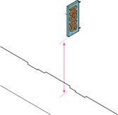
Sign Content Height. The vertical distance between the lowest point on a sign, not including the supporting structure, and the highest point on a sign, not including the supporting structure.
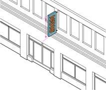
Sign Height. The vertical distance measured from the lowest adjacent grade to the highest point of the sign or sign structure. The overall height of a freestanding sign shall be computed as the distance from the base of the sign support structure at average grade to the top of the highest attached component of the sign. In cases in which the average grade cannot reasonably be determined, sign height shall be computed on the assumption that the elevation of the grade at the base of the sign is equal to the elevation of the nearest point of the crown of a public road or the grade of the land at the primary entrance to the lowest principal structure on the lot, whichever is lower.
Significant Modification. Any development, other than cosmetic or decorative, or any change in the structural members of buildings, such as bearing walls, columns, beams, or girders, that changes the footprint or height of a structure or its associated paved areas.
Small Light Industrial. A principal use of a lot consisting of an establishment engaged in the indoor warehousing, manufacturing, assembly, fabrication, packaging or other industrial processing of finished parts or products, primarily from previously prepared materials, or the indoor provision of industrial services, where there are few external effects across property lines. This term includes but is not limited to a business engaged in the processing, fabrication, assembly, treatment, or packaging of food, textile, leather, wood, paper, chemical, plastic, or metal products, but does not include basic industrial processing from raw materials. Small light industrial uses have principal structures of less than 25,000 square feet per lot.
Small Lodging. A principal or accessory use consisting of a structure of no more than 5,000 square feet in which eight or fewer rooms are rented to paying transients or travelers on a per-night, per-weekend, or perweek basis.
Small Outdoor Recreation. A principal use that provides small outdoor parks for play and relaxation within walking distance of residential neighborhoods, on a lot of under two acres in size, and with no more than eight off-street parking spaces. This use includes playgrounds, pocket parks, parklets, basketball courts, tennis courts, small pools, and promenades. Cemeteries of two acres or less and with no more than 8 parking spaces are considered small outdoor recreation uses.
Small Retail. A principal use consisting of the selling or leasing of goods directly to household consumers in retail spaces up to 5,000 sq. ft. of GFA per lot. For the purposes of calculating GFA for this definition, retail units in attached structures that straddle lot lines and are under common ownership or management shall be calculated as being located on the same lot. Retail includes, but is not limited to, the selling or leasing of clothing, unprepared food, home goods and furnishings, collectibles and antiques, electronics, non-motorized recreation equipment, art and décor, pets and pet care products, and appliances.
Small Surface Parking. A principal or accessory use consisting of an off-street, ground-level area improved for the temporary storage of motor vehicles and not exceeding 5,000 square feet per lot.
Solicitor. The solicitor of the City.
Specified Anatomical Areas. The less than completely and opaquely covered human genitals, pubic region, buttock, and female breast below a point immediately above the top of the areola, or the human male genitals in a discernibly turgid state even if completely and opaquely covered.
Specified Sexual Activities. Activities that include human genitals in the state of sexual stimulation or arousal; acts, real or simulated, of human masturbation, sexual intercourse, sodomy, cunnilingus, or fellatio; fondling or other erotic touching of human genitals, pubic regions, buttock, or female breasts.
Story. That part of a building between the surface of a floor (whether or not counted for purposes of computing floor area) and the ceiling immediately above.
Stream. A body of water running or flowing on the earth’s surface or a channel in which such flow occurs. Flow may be ephemeral, seasonally intermittent, or perennial.
Street Level. In buildings with more than one story, the story of a building that has a floor elevation most nearly the same as the average grade of the front setback line and that receives persons entering at the primary architectural entranceway of the building. In buildings with two street frontages, the street level for one frontage may differ from the street level for another frontage due to significant average grade differences between the frontages.

36:

Street Right-of-way. A public or private right-of-way of a width of more than 20 feet or providing primary access to property(s) abutting such street right-of-way. A street right-of-way differs from an alley in that it provides primary access to property and is typically wider. A street right-of-way differs from other rights-ofway, such as walkways and bikeways, in that it is typically intended for motor vehicles, although many street rights-of-way also contain walkways or bikeways adjacent to motorways, and, in such cases, the walkways or bikeways are considered to be parts of the street rights-of-way. A street right-of-way differs from a driveway in that a driveway is contained majorly within a lot intended for purposes other than the movement of people and vehicles, whereas a street right-of-way is not contained by a lot.
Structure. A combination of materials, other than a fence, that form a construction for use, occupancy, or ornamentation whether installed on, above, or below the surface of land or water.
Structure Height. Structure height is the difference in elevation of:
(1) A horizontal line at the average grade along the structure’s front elevation; and
(2) The highest point of the roof, including parapets and cornices.
Exceptions to structure height regulations are found in Chapter 1131.
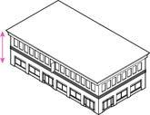
Structured Parking. A principal or accessory use consisting of a structure designed to accommodate more than 800 square feet of vehicular parking spaces that are fully or partially enclosed or located on the deck surface of a building and are partially or fully above or below grade. This definition includes parking garages, deck parking, and underground or under-building parking areas.
Subdivision. Any division, resubdivision, or change of the lines of a lot or group of lots into two or more lots or other divisions of land for the purpose, whether immediate or future, of lease, sale, or transfer of ownership or of development, including the creation of street or lot lines.
Taxi and Car Rental Services. A principal use consisting of the hiring or leasing of a taxi or personal car or light truck for a period as brief as a portion of one day. A taxi and car rental services use may also conduct cleaning, refueling, and light maintenance on a vehicle fleet, and may provide space for offices, respite, and hiring of drivers and support staff. The term taxi and car rental services does not include uses that regularly perform collision or heavy repair to automobiles and does not include uses that sell vehicles on premises.
Temporary Sign. A sign that is not permanently affixed to a structure or permanently embedded in the ground, and is designed to be displayed for a short period of time, specifically fewer than 180 days in a calendar year.
Temporary Wireless Communications Facilities. A cellular-on-wheels unit; an antenna on a bucket truck, crane, crank-up tower, tower; or another wireless communications facility required to evaluate a site for a temporary placement of a wireless communications facility as permitted by this chapter or for providing communications during an emergency, special event, conference, or other situations for limited periods while the use of a permanent wireless communication facility is temporarily interrupted or overwhelmed.
Topsoil. The surface and upper surface soils which presumably are darker colored, fertile soil materials, ordinarily rich in organic matter or humus debris.
Tower. Any structure designed and constructed primarily for the purpose of supporting one or more antennas for telephone, radio, and similar communication purposes, including self-supporting, or monopole towers. The term includes radio and television transmission towers, microwave towers, common-carrier towers, wireless communications towers, and the like. The term includes the structure and any necessary supports.
Through-Lot. A lot with two street frontages that do not intersect. Typically, a through-lot is a rectangular lot with streets forming the boundaries of the lot on opposing sides.
Use. The specific purpose for which land or a building is designed, arranged, intended or for which it is or may be occupied or maintained. The term “permitted use” or its equivalent shall not be deemed to include any nonconforming use.
USGS. The United States Geological Survey.
V.
Variance. A grant of relief from certain standards of this Zoning Code.
Wall Sign. Any building sign painted on, attached flush against, or extending not more than one foot from an exterior wall in a parallel manner.
Window Sign. A permanent sign that is painted or mounted onto a windowpane, or that is hung directly inside a window.
Wireless Communications Facilities or WCF. Includes, but shall not be limited to, towers, poles, cables, wires, lines, wave guides, antennas, microwave dishes, and/or any other equipment or facilities associated with the transmission or reception of communications as regulated by the FCC (or other unregulated wireless communication facility). The term shall not include:
(a) Any satellite earth station antenna two meters or less in diameter or diagonal measurement located in a non-residential district.
(b) Any satellite earth station antenna one meter or less in diameter or diagonal measurement that is designed to receive direct broadband satellite service, including direct-to-home satellite services, or to receive or transmit fixed wireless signals via satellite regardless of zoning category.
(c) Any antenna that is one meter or less in diameter or diagonal measurement and is designed to receive video programming service via broadband video services (wireless cable) or to receive or transmit fixed wireless signals other than via satellite.
(d) Any antenna that is designed to receive local television broadcast signals and does not use a mast higher than 12 feet above the tallest point of the roof of the tallest principal or accessory structure, excluding chimneys, cupolas, or other architectural elements.
(e) Antennas used by amateur radio operators.
(f) Towers, structures, antennas, or other equipment used for the purposes of operating a public safety voice or data radio network or an outdoor early warning system within the City limits. This includes directional and omnidirectional antenna equipment, as well as microwave and point-to-point equipment.
X.
None.
Y.
None.
Z.
Zone. See District.
Zoning Code. The current zoning ordinance of the City.