
ZONING REGULATIONS
WINCHESTER, CONNECTICUT
Planning and Zoning Commission
Last Modified: June 27, 2022
Effective Date: June 30, 2022
I. INTRODUCTION TO AND USING THE ZONING REGULATIONS
A. APPLICABILITY AND PURPOSE
These Regulations shall apply, and all land, buildings, premises, or part thereof, shall hereafter be used, constructed, reconstructed, extended, enlarged, moved and altered in conformity with these Regulations. They are adopted for the following purposes in accordance with the Connecticut General Statutes (C.G.S.), as amended:
1. To promote and to protect the public health, safety, and welfare of the inhabitants of the Town of Winchester, Connecticut (hereinafter referred to as the “Town”), and of the public generally;
2. To encourage the most appropriate use of land throughout the Town, thereby conserving the value of properties;
3. To regulate the height, number of stories and size of buildings and other structures; the percentage of the area of the lot that may be occupied; the size of yards, courts, and other open spaces; and the height, size, character and location of signs;
4. To regulate the density of population and the location and use of buildings, structures and land for trade, industry, residence, or other purposes;
5. To divide the Town into zoning districts of such number, shape, and area as may be best suited to carry out the purposes of these Regulations;
6. To regulate the erection, construction, reconstruction, alteration, or use of buildings or structures and the use of land in such zoning districts;
7. To permit certain classes or kinds of buildings, structures or uses of land within the Town only after obtaining a Special Permit;
8. To lessen congestion in the streets;
9. To secure safety from fire, panic, flood, and other dangers;
10. To provide adequate light and air;
11. To prevent the overcrowding of land and avoid undue concentration of population;
12. To facilitate the adequate provision for transportation, water, sewerage, schools, parks and public requirements;
13. To further the policies of the Plan of Conservation and Development;
14. To guide development in a manner which recognizes the importance of the natural environment and the Town’s natural resources;
15. To protect the value of buildings and property throughout the Town and the Town’s ground and surface waters;
16. To preserve the historical resources, natural features and visual qualities that enhance the character of the Town;
17. To encourage development of housing opportunities for all citizens of the Town consistent with soil types terrain and infrastructure capacity;
18. To prevent unreasonable pollution, impairment or destruction of the public trust in air, water or other natural resources of the Town;
19. To guide development which minimizes impacts to wetlands, watercourses, flood prone areas, hillsides, surface water and groundwater resources, and other sensitive and significant features of the natural landscape, and to establish soil erosion and sedimentation controls;
20.To encourage energy-efficient patterns of development, the use of solar and other renewable forms of energy and energy conservation; and
21. For such other purposes as specified in C.G.S. Chapter 124.
B. INVALIDITY
The invalidity of any word, clause, sentence, paragraph, section, subsection, part or provision of these Regulations shall not affect the validity of any other word, clause, sentence, paragraph, section, subsection, part or provision which can be given effect without such invalid part or parts. The invalidity of these Regulations with respect to any particular activity shall not invalidate these Regulations with respect to other activities.
C. INTERPRETATION
In interpreting and applying these Regulations, the Regulations shall be considered as the minimum requirements for the promotion of the public health, safety, and general welfare. When these Regulations impose a greater restriction on the use of buildings or structures or require larger yards, courts, or other open spaces, or require a greater percentage of lots to remain unbuilt, or impose other standards higher than those imposed by federal or state law or regulation, local ordinance or regulation, or private agreement, these Regulations shall control. When restrictions are imposed by any law, ordinance, regulation, or private agreement, which are greater than those required by these Regulations, such greater restrictions shall not be affected by these Regulations. When one section of these Regulations imposes standards greater than those of another section, the standards of the more restrictive section shall control.
In the construction of these Regulations, the words and definitions contained herein shall be observed and applied, except where the context clearly indicates otherwise, as follows:
1. Words used in the singular shall include the plural, and words used in the plural shall include the singular; words used in the present tense shall include the future tense.
2. The word “shall” is mandatory and not discretionary.
3. The word “may” is permissive.
4. The word “lot” shall include the words “piece,” “parcel,” “premises,” or “land.”
5. The words “zone,” “zoning district,” and “district” have the same meaning.
6. The phrase “used for” shall include the phrases “arranged for,” “designed for,” “intended for,” “maintained for,” and “occupied for.”
7. The word “subdivision” shall include “resubdivision.”
8. The phrase “these Regulations” shall refer to the entire Zoning Regulations including the Official Zoning Map.
9. Uses of land, buildings, or structures not expressly permitted in the various districts are prohibited.
D. MEASUREMENT AND CALCULATION
1. Measuring Distances: use the shortest distance along a horizontal plane from the lot line and the edge of a structure, irrespective of the topography of the land.
2. Measuring Height: use the vertical distance above the average natural grade of the outside ground level along all walls of a building to the midpoint of the roof.
3. Measuring Lot Width: lot widths are measured at the rear of the Minimum Front Yard or at the Street Line, whichever is least.
4. Calculating Lot Area: minimum lot area requirements shall be exclusive of easements or other permanent restrictions prohibiting building or development, including, but not limited to areas covered by Waters.
E. ZONING MAP
1. When uncertainty exists in the opinion of the Commission or the Zoning Enforcement Officer as to the boundaries of districts as shown on the Official Zoning Map, the following rules shall apply:
a. District boundaries indicated as approximately following the center lines of streets, highways or alleys, shall be construed as following said center lines;
b. District boundaries indicated as approximately following lot lines shall be construed as following such lot lines;
c. District boundaries indicated as approximately following Town limits shall be construed as following Town limits;
d. District boundaries indicated as following railroad rights-of-way shall be construed as the center of said rights-of-way;
REGULATIONS
e. Boundaries indicated as approximately following the center line of streams, brooks, natural water courses and other bodies of water shall be construed as following such center lines; and
f. District boundaries which are set back from streets and approximately parallel to such streets shall be construed as parallel to such streets and, unless specific dimensions are shown on the Official Zoning Map, shall be construed to be:
i. For Town Districts, 100 feet from the street line; and
ii. For Rural and Lake Districts, 150 feet from street line.
F. DENSITY, BUILDABLE AREA AND BUILDING COVERAGE CALCULATIONS FOR CERTAIN UNBUILDABLE LANDS
When calculating density, buildable area or building coverage in any district, where such calculations apply, no land consisting of wetland soils, FEMA designated 100-yr floodplain, water bodies, watercourses, or land with slopes in excess of 25%, shall be included as part of the calculations.
II. ZONING DISTRICTS
A. TSF TOWN SINGLE FAMILY
TSF districts are intended to reflect and promote a low-intensity single-family residential development pattern. In these districts, use and density regulations are of primary importance to maintain existing and to promote desired development patterns. Certain uses are permitted, while others require a Special Permit. All other uses are prohibited. Density is controlled by the establishment of a uniform set of setback, building coverage, and height regulations, which determine the size of a building, and will vary depending on the size of the lot. The natural environment is considered through the establishment of a maximum impervious surface coverage ratio.
a. USES
i. Permitted Uses
Accessory Residential Uses
Family Day Care Home
Home Farming
Single-Family Dwelling
ii. Special Permit Required
Accessory Apartment
Affordable Housing
Bed and Breakfast
Cemetery Club
Country Inn
Group Day Care Home
Home Occupation
Manufactured Home
Open Space Subdivision
Public Recreation Facility
Public Safety Facility
Public Utility Facility
Recreation and Entertainment
Facility, Outdoor Private School
Two Family Dwelling
Worship Place
b. BUILDINGS
i. Building Dimensions & Placement
Minimum Street Frontage of Lot = 150 ft.
Minimum Front Yard Setback = 25 feet
Minimum Rear Yard Setback = 25 feet
Minimum Side Yard Setback = 10 feet
Maximum Building Coverage = 25%
Maximum Height = 35 feet
Maximum Impervious Surface Coverage = 40%
One principal building per lot
c. PARKING & SIGNAGE
i. Off-Street Parking
Parking is allowed on a driveway leading to the principal building or use and on circular driveways located in a front yard
Front yard parking is not otherwise allowed
SEE TABLE OF USES AND PARKING REQUIREMENTS AT APPENDIX A
ii. Sign Types
Signs are not allowed unless approved as part of a Special Permit (Maximum of two different sign types), or exempt signs For signs related to a Family Day Care Home – See Sign Types in Common Regulations
B. TCR TOWN CENTER RESIDENTIAL
TCR districts are intended to reflect and promote a higher density, walkable development pattern. In these districts, use and density regulations are of primary importance to maintain existing and to promote desired development patterns. Certain uses are permitted, while others require a Special Permit. All other uses are prohibited. Density is controlled by the establishment of a uniform set of setback, building coverage, and height regulations, along with an allowable number of units per acre, which determine the size of a building, and will vary depending on the size of the lot. The natural environment is considered through the establishment of a maximum impervious surface coverage ratio.
a. USES
i. Permitted Uses
Accessory Residential Uses
Community Center, Private Family Day Care Home
Single-Family Dwelling
Home Farming
ii. Special Permit Required
Affordable Housing
Bed and Breakfast
Boarding House
Cemetery
Congregate Residence
Continuing Care Retirement
Community
Convalescent Home/Nursing Home
Country Inn
Home Occupation
Independent Living / Retirement Facility
Industrial Heritage Reuse
Mixed-Use Building
Multi-Family Dwelling
Public Recreation Facility
Public Safety Facility
Public Utility Facility
Recreation and Entertainment Facility,
Outdoor Private Restaurant
School
Two Family Dwelling
Worship Place
b. BUILDINGS
i. Dimensions & Coverage
Accessory Structures:
Minimum Front Yard Setback = 25 feet
Other Setbacks per Principal Structures, below
Principal Structures:
Minimum Street Frontage of Lot = 150 ft.
Minimum Lot Area/Dwelling Unit = 1,000 sq. ft.
Minimum Front Yard Setback = 10 feet
Minimum Side Yard Setback = 10 feet
Minimum Rear Yard Setback = 10 feet
Maximum Building Height = 50 feet
Maximum Impervious Surface Coverage Ratio: 30%
One principle building per lot except as otherwise allowed via a Special Permit
c. PARKING & SIGNAGE
i. Off-Street Parking
SEE TABLE OF USES AND PARKING REQUIREMENTS AT APPENDIX A
ii. Permitted Sign Types
Maximum of two different sign types per Multi-Family Development as listed on Sign Type and Quantity Table at Article III(G)
For signs related to a Family Day Care Home – See Sign Types in Common Regulations
C. TC TOWN CENTER
TC districts are intended to reflect and promote a traditional mixed-use business district characteristic of New England town centers. In these districts, a mix of permitted uses and a walkable urban form is of primary importance to maintain existing development patterns and to promote desired development patterns. Certain uses are permitted, while others require a Special Permit. All other uses are prohibited. Additional density is promoted in the Town Center.
a. USES
i. Permitted Uses
Accessory Residential Uses
Artisan Production
Bakery
Banks and Financial Institutions without Drive-Thru Commissary
Country Inn
Cultural Institution
Drug Store, Small Format
Family Day Care Home
Home Farming
Home Occupation
Medical Office, Small Format
Office, Business Small Format
Office, Professional Small Format
Public Administrative Services and Courts
Restaurant
Retail, Grocery Small Format
Retail, Personal Service
Retail, Small Shop
Note
a. USES (continued)
ii. Special Permit Required
Accessory Apartment
Affordable Housing
Automotive Sales & Repair
Bank and Financial Institutions with Drive-Thru
Banquet Facility
Bed and Breakfast
Brewpub
Brewery, Large Brewery, Micro
Boarding House
Cannabis Establishments
Cemetery
Club
College
Congregate Residence
Continuing Care Retirement
Community
Convalescent Home/Nursing Home
Distillery
Funeral, Undertaking and Internment Service
Group Day Care Home
Hospital
Hotel
Independent Living Retirement Facility
Industrial Heritage Re-Use
Manufacturing, Light
Medical Marijuana Dispensary
Facility
Mixed-Use Building
Motor Vehicle Fuel Sales with Convenience Retail
Multi-Family Dwelling
Office, Business Large Format
Office, Professional Large Format
Outdoor Dining (Accessory Use)
Parking Lot
Public Recreation Facility
Public Safety Facility
Public Utility Facility
Recreation and Entertainment
Facility, Indoor Private
Recreation and Entertainment
Facility, Outdoor Private
School
Tap/Tasting Room
Taverns
b. BUILDINGS
i. Building Dimensions & Placement
Accessory Structures:
Minimum Front Yard Setback = 25 feet
Other setbacks as per Principal Structures, below
Principal Structures:
Maximum Front Yard Setback = 5 feet
Maximum Side Yard Setback = 3 feet
Maximum Rear Yard Setback = 10 feet
Minimum Building Coverage = 75% Maximum Height = 75 feet
c. PARKING & SIGNAGE
i. Off-Street Parking Not required
ii. Permitted Sign Types
Maximum of two different sign types as listed on Type and Quantity Table at Article III(G)
For signs related to a Family Day Care Home – See Sign Types in Common Regulations
The Zoning Enforcement Officer may approve a change in use between one Permitted Use and another Permitted Use in the TC Zone
D. TG TOWN GATEWAY
TG districts are intended to reflect and promote positive impressions about the Town. In these districts, the Regulations are tailored to promote desired development patterns that promote an appropriate transition from rural to town uses. Certain uses are permitted, while others require a Special Permit. All other uses are prohibited. Building setbacks, parking, signage and landscaping regulations are of particular importance in these areas.
a. USES
i. Permitted Uses
Accessory Residential Uses
Artisan Production
Bakery
Commissary
Community Center, Private Country Inn
Cultural Institution
Drug Store, Small Format
Family Day Care Home
Farm
Home Farming
Home Occupation
Medical Office, Small Format
Office, Business Small Format
Office, Professional Small Format
Public Administrative Services and Courts
Restaurant
Retail, Grocery Small Format
Retail, Personal Service
Retail, Small Shop
Roadside-Oriented Limited Retail
Enterprise
ii. Special Permit Required
Accessory Apartment
Affordable Housing
Bank and Financial Institutions with Drive-Thru
Banks and Financial Institutions without Drive-Thru
Banquet Facility
Bed and Breakfast
Brewery, Large Brewery, Micro
Brewpub
Bulk Storage
Cannabis Establishments
Car Wash
Cemetery
Club
College
Congregate Residence
Continuing Care Retirement Community
Note
ii. Special Permit Required (continued)
Convalescent Home/Nursing Home
Distillery
Drug Store, Large Format
Earth Excavation
Farm Stand, Permanent
Farm Winery
Funeral, Undertaking and Internment
Service
Greenhouse/Nursery, Commercial Group Day Care Home
Hospital
Hotel
Independent Living Retirement Facility
Industrial Heritage Re-Use
Kennel
Landscaping/Construction Yard
Manufacturing, Light
Medical Marijuana Dispensary Facility
Medical Office, Large Format
Mixed-Use Building
Motor Vehicle Fuel Sales with Convenience Retail
Motor Vehicle Fuel Sales without Convenience Retail
Multi-Family Dwelling
Office, Business Large Format
Office, Professional Large Format
Outdoor Dining (Accessory Use)
Public Recreation Facility
Public Safety Facility
Public Utility Facility
Recreation and Entertainment Facility, Indoor Private
Recreation and Entertainment Facility, Outdoor Private
Research and Development Facility
Restaurant, High Turn-Over/Fast Food with or without a Drive-Thru
Retail, Convenience
Retail, Grocery Large Format
Retail, Large Shop
School
Stable, Commercial
Storage Business, Outdoor Limited
Storage, Personal and Mini-Warehouse
Tap/Tasting Room
Taverns
Vehicle Sales and Service, Personal Worship Place
ii. Special Permit Required (continued)
Vehicle Sales and Service; Pleasure
Vehicle Sales and Service; Professional
Veterinary Hospital
Warehouse, Small
Warehouse, Large
Wholesale and Distribution Business
b. BUILDINGS
i. Lot Dimensions & Coverage
Minimum Lot Width = 100 feet
ii. Building Dimensions & Placement
Minimum Front Setback = 30 feet
Minimum Side Setback = 15 feet
Minimum Rear Setback = 30 feet
Maximum Height = 50 feet
Maximum Impervious Surface Coverage = 50%
c. PARKING & SIGNAGE
i. Off Street Parking SEE TABLE OF USES AND PARKING REQUIREMENTS AT APPENDIX A
ii. Permitted Sign Types
Maximum of two different sign types as listed on Sign Type and Quantity Table at Article III(G) For signs related to a Family Day Care Home – See Sign Types in Common Regulations
E. PI PRODUCTION AND INNOVATION
Production and innovation is a hallmark of the Town’s history and is an important part of its current and future economy. PI districts are intended to provide for the continuation of the manufacture, compounding, assembly, fabrication, processing and packaging of goods in portions of the Town traditionally devoted to these uses along the Still and Mad Rivers. Certain uses are permitted, while others require a Special Permit. All other uses are prohibited. Less intense uses are permitted as of right, with more intense uses requiring approval of a Special Permit. Live-work spaces and a mix of non-industrial commercial uses are also encouraged in these areas.
a. USES
i. Permitted
Uses
Adult-Oriented Establishment
Artisan Production
Bakery
Brewery, Large Brewery, Micro Brewpub
Bulk Storage Facility
Cannabis Establishments
Car Wash
Cold Plant Storage Commissary
Community Center, Private Distillery
Farm
Farm Stand, Permanent Industrial Laundry
Kennel
Laboratory
Manufacturing, Light Office, Business, Small and Large Format
Public Administrative Services and courts
Recreation and Entertainment Facility, Indoor Private Research & Development Facility
Stable, Commercial Storage, Business Outdoor Limited Storage, Personal and MiniWarehouse
Tap/Tasting Room
Vehicle Sales & Service, Personal Vehicle Sales & Service, Pleasure
Vehicle Sales & Service, Professional Veterinary Hospital
Warehouse, Large Warehouse, Small Wholesale and Distribution Business
ii. Special Permit Required
Cemetery
Funeral, Undertaking and Internment Service
Greenhouse/Nursery Commercial
Earth Excavation
Industrial Heritage Reuse
Manufacturing, Heavy
Medical Marijuana Dispensary Facility
Medical Marijuana Production Facility
Public Recreation Facility
Public Safety Facility
Public Utility Facility
Recreational Facility, Outdoor
Private Recycling Facility
b. BUILDINGS
i. Lot Dimensions & Coverage
Minimum Lot Area = 20,000 sq. ft.
Minimum Lot Width = 100 feet
ii. Building Dimensions & Placement
Minimum Front Setback = 50 feet
Minimum Side Setback = 15 feet
Minimum Rear Setback = 30 feet
Maximum Building Coverage = 30%
Maximum Height = 70 feet
Maximum Impervious Surface Coverage = 75%
c. PARKING & SIGNAGE
i. Off Street Parking
SEE TABLE OF USES AND PARKING REQUIREMENTS AT APPENDIX A
ii. Permitted Sign Types
Maximum of three different sign
types as listed on Sign Type and Quantity Table at Article III(G) For signs related to a Family Day Care Home – See Sign Types in Common Regulations
F. RR RURAL RESIDENTIAL
RR districts make up a significant portion of the Town’s land area. They are characterized by rolling, wooded hills with low-intensity agriculture uses and single-family estate residences. Maintaining the natural and low-density character of these areas is the focus on these districts. Permitted land uses are limited and density is purposefully low in these districts. Certain uses are permitted, while others require a Special Permit. All other uses are prohibited.
a. USES
i. Permitted Uses
Accessory Residential Uses
Family Day Care Home
Farm
Home Farming
Seasonal Cottages
Single-Family Dwelling
ii. Special Permit Required
Accessory Apartment
Affordable Housing
Banquet Facility
Bed and Breakfast
Cemetery
Club
Commercial Recreation
Congregate Residence (*)
Country Inn
Earth Excavation
Farm Stand, Permanent
Farm Winery
Greenhouse/Nursery, Commercial
Group Day Care Home
Home Occupation
Kennel - including training
Manufactured Home
Open Space Subdivision
Public Recreation Facility
Public Safety Facility
Public Utility Facility
Recreation and Entertainment
Facility, Outdoor Private
Roadside-Oriented Limited Retail
Enterprise School
Stable, Commercial Veterinary Hospital
Worship Place
(*) Public Water and Sewer Required
b. BUILDINGS
i. Lot Dimensions & Coverage
Minimum Lot Area = 85,000 sq. feet
Minimum Lot Width = 200 feet
ii. Building Dimensions & Placement
Minimum Front Yard = 50 feet
Minimum Side Yard = 30 feet
Minimum Rear Building Yard = 35 feet
Maximum Building Coverage = 10%
Maximum Height = 30 feet
Maximum Impervious Surface
Coverage = 15%
One principle building per lot
c. PARKING & SIGNAGE
i. Off Street Parking
Parking is allowed on a driveway leading to a principal building and on circular driveways located in a front yard
SEE TABLE OF USES AND PARKING REQUIREMENTS AT APPENDIX A
ii. Permitted Sign Types
One freestanding sign permitted for commercial establishments and Farms as listed on Sign Type and Quantity Table at Article III(G) For signs related to a Family Day Care Home – See Sign Types in Common Regulations
G. HL HIGHLAND LAKE DISTRICT
The HL District reflects the unique character and development patterns on and around Highland Lake. The regulations for the district are designed to reduce overcrowding and limit incompatible land uses in this area. They are also intended to protect the lake from excessive stormwater runoff. Certain uses are permitted, while others require a Special Permit. All other uses are prohibited.
a. USES
i. Permitted Uses
Accessory Residential Uses
Home Farming
Seasonal Cottage
Single-Family Dwelling
Family Day Care
ii. Special Permit Required
Accessory Apartment
Affordable Housing Bed and Breakfast
Cemetery
Club
Convalescent Home/Nursing Home
Country Inn
Farm Stand Permanent
Farm Winery
Greenhouse/Nursery Commercial
Home Occupation
Public Recreation Facility
Public Safety Facility
Public Utility Facility
Recreation and Entertainment Facility,
Outdoor Private School
b. BUILDINGS
ii. Building Dimensions & Placement
Minimum Front Setback = 50 feet
Minimum Side Setback = 35 feet
Minimum Rear Setback = 35 feet
Minimum Setback from the lake’s high-water mark = 35 feet
Maximum Impervious Surfaces = See following pages
Height = See following pages
One principle building per lot
c. PARKING & SIGNAGE
i. Off Street Parking
None required unless as part of a Special Permit.
ii. Permitted Sign Types
One freestanding sign permitted for commercial establishments and farms as listed on Sign Type and Quantity
Table at Article III(G)
No other signs unless permitted as part of a Special Permit (Maximum of two different sign types)
For signs related to a Family Day Care Home – See Sign Types in Common Regulations
See (d) on next page for Additional Regulations of the HL district.
Additional Regulations of the HL District
i. Building Height.
Buildings in the HL district shall be no taller than 30 feet in height. The building height is the distance between a horizontal line at the average existing pre-development grade of the lot directly beside the structure, and the highest point of the coping of a flat roof, the top of a mansard roof, the midpoint of any pitched gable, hip or the upper portion of a gambrel roof, or measured between the top floor ceiling and the peak of the roof on an “A” framed structure.

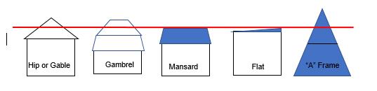
line above denotes building height for various building roof types
ii. Impervious Surfaces.
Except as otherwise provided herein, impervious surfaces on a lot shall not exceed 15% of the total area of the lot; provided, however, if LID Regulations are employed in the development of the lot, then the lot may, by Special Exception issued by the Zoning Board of Appeals, receive a 5% impervious surface bonus to allow for a maximum of 20% impervious surfaces on a lot. The LID practice(s) must provide a “Primary Stormwater Treatment Practice as described in section 6.2 of the 2004 CT Stormwater Quality Manual, as amended, that will accept, at the least, the “Water Quality Volume” (1st inch of rainfall) of storm water generated by the activities on the property that are in excess of the 15% limit.
For driveways, walkways and patios, if a design showing an engineered pervious design, such as pervious pavers, asphalt or concrete is utilized along with an appropriate base, these surfaces shall be exempt from the above limits. Such design must demonstrate that the product will be able to completely accept at least the “Water Quality Volume” (1st inch of rainfall) for the life of the surface. Decks constructed over a pervious surface such as grass or soil shall also be exempt from the above limits.
iii. Fences and Walls. All fences and walls in the HL district shall comply with these Regulations, and all fences or walls within 20 feet of the high waterline or exceeding four feet in height shall require a Special Permit approved by the Commission in accordance with the following:
a) In reviewing applications under this section, the Commission shall take into consideration the impact of proposed fences or walls on the visual access to Highland Lake from both private properties and the public way, and to the greatest extent possible, fences and walls shall be located in such a way as to maintain views of Highland Lake from neighboring properties and from the nearest public right-of-way. At a minimum, fences or walls shall be located to maintain one straight-line uninterrupted view-shed
Red
Diagram showing example Building Height Calculation.
area to Highland Lake per lot as viewed from the nearest public right-of-way. The width of the view-shed area shall be not less than nine feet and shall be located within the side yard of the lot.
b) Fences and walls shall not exceed six feet in height, the design of which shall be semiopen, such as the examples shown below.
c) Fences located within 20 feet of the high-water line of Highland Lake shall not exceed four feet in height, the design of which shall be semi-open, such as the examples shown below.
d) Walls located within a required front yard or within 20 feet of the high-water line of Highland Lake shall not exceed a height of 36 inches.
e) The height of fences or walls shall be measured from the ground on which the fence or wall sits. In the event that one or more fence section(s) does not touch the ground, the height shall be measured from the ground immediately adjacent to such fence section, whichever is lesser. Fence posts, columns, and decorative caps may be permitted to exceed the maximum fence heights by not more than 12 inches.
f) All fences shall be constructed so that the finished side shall face outward toward the abutting lots and rights-of-way.
g) To allow access for maintenance, fences and walls shall be located at least two feet from all property lines, or, with mutual written consent from the adjoining lot owner (s), which shall be notarized, may be located on the lot line.
h) Retaining walls and, temporary construction & erosion control fences are exempt from these additional requirements.
i) All applications for a Special Permit approval under this section shall be accompanied by the following:
i) Copies of an application and fees as prescribed by the Commission;
ii) Copies of a site plan, drawn to scale not to exceed 1 inch equals 50 feet showing all the lot lines, structures, easements or rights-of-way, natural features, and location of the proposed fence or wall, which shall also include dimensions of the proposed fence or wall as well as setback distances;
iii) Copies of the Assessor’s map(s) showing the subject lot and all the lots within 300 feet of the subject lot;
iv) Copies of a drawing of the proposed fence or wall at a scale not to exceed 1/8 inch equals 1 foot, showing the height, building materials and style of the proposed fence or wall; and
5”x7” color photographs of the lot, site area and surrounding neighborhood.
j) Examples of a Semi-Open Fence, shown below:

k) The subject structure does not encroach within the side yard to an extent greater than the existing principal building and limited to a minimum side yard of 9 feet.
l) A landscape buffer planted parallel to the side yard for the full length of both sides of the proposed structure, which shall create a permanent screening element between lots.
m) The subject structure is not within 20 feet of the lake shore/retaining wall face/high water level of Highland Lake.
iv. Decks, Patios, Pergolas, Terraces, Steps Needed for Building Access, and Accessibility Features. Decks, patios, terraces, and steps needed for building access, including Accessibility Features, may be added to buildings within the HLD district within the required setbacks provided:
a) The subject structure, other than steps in paragraph d below, shall be installed no closer to the boundary than the existing Principal Building, or nine (9) feet, whichever is greater.
b) The subject structure is not within 20 feet of the lake shore/retaining wall face/high water level, or a front or rear property line.
c) There shall be a landscaped buffer on the subject lot between the proposed subject structure and the neighboring lot to provide screening between lots. A single hedge row of deciduous or coniferous plantings, at least 5 feet high, and spaced as recommended by the grower when used as a screening planting, shall be provided for this purpose.
d) Steps required for building access are no larger than what is required by the building code and shall be positioned to minimize the incursion into a front, rear or side yard setback when possible (steps besides, rather than perpendicular to, the served structure). Such steps may be covered for safety purposes, but no habitable space shall be built above such stairways.
e) Accessibility Features for use by disabled individuals, such as ramps and expanded stoops which are wanted for access, may be installed under this provision, provided the feature is not any larger than recommended by ADA standards and is configured to intrude as little as possible into the required setback.
f) These Decks, Patios, Terraces, Steps and Accessibility features shall not be increased in height, as otherwise allowed in III.C.4.b. nor increase in total size to more than 400
square feet. Decks in excess of 400 square feet are permitted through a Special Exception from the Zoning Board of Appeals.
v. Prohibited Screening. No earthen berms or other similar features shall be utilized for screening in the HL district.
vi. Special Regulations for Subdivision in the HL District. Any subdivision of land in the HL district shall utilize the Open Space Subdivision Regulations.
H. HLB HIGHLAND LAKE BUSINESS DISTRICT
The HLB District reflects the unique character and development pattern of the small cluster of businesses located at the north end of Highland Lake. The regulations for the district are designed to promote the character of the area and limit incompatible land uses. Uses require a Special Permit. All other uses are prohibited.
a. USES
i. Permitted Uses
None
ii. Special Permit Required
Banquet Facility
Bed and Breakfast
Brewpub
Club
Country Inn
Hotel
Marina, including boat sales and/or storage, repair and fueling
Mixed-Use Building
Multi-Family Dwelling
Public Recreation Facility
Recreation and Entertainment Facility, Outdoor Private
Restaurant
Retail, Convenience
Retail, Grocery Small Format
Retail, Personal Service
Retail, Small Shop
Tap/Tasting Room
b. BUILDINGS
ii. Building Dimensions & Placement
Minimum Front Setback = 5 feet
Minimum Side Setback = 5 feet
Minimum Rear Setback (for nonlake front properties) = 25 feet
Minimum Setback from the lake’s high water mark = 0 feet
Maximum Impervious Surfaces = 75%
Height = 50’
c. PARKING & SIGNAGE
i. Off Street Parking SEE TABLE OF USES AND PARKING REQUIREMENTS AT APPENDIX A
ii. Permitted Sign Types
One sign of any type, listed on Sign Type and Quantity Table at Article III(G)
No other signs unless permitted as part of a Special Permit (Maximum of two different sign types) For signs related to a Family Day Care Home – See Sign Types in Common Regulations
All Additional Regulations of the HL District shall apply in the HLB District. See HL District, Section (d).
III. COMMON REGULATIONS
A. ARCHITECTURAL REVIEW
This Section is intended to aid applicants in ensuring that their designs are in harmony with the character of the community, encourage high quality building and site design, and result in development or re-development that is compatible with the character of the community. Adherence to preservation of local historic places should be considered.
1. Establishment.
a. The Commission shall appoint an Architectural Review Committee. The Committee shall consist of five regular members and two alternate members. The Town Planner shall be a regular member of the committee. Initially two members shall be appointed to a term of one year, two members shall be appointed to a term of two years, and one member shall be appointed to a term of three years. Thereafter, all members shall be appointed to a term of three years. Initially, one alternate member shall be appointed to a term of one year and one alternate member shall be appointed to a term of two years. Thereafter, all alternate members shall be appointed to a term of three years. At least one alternate or regular member should be an architect or landscape architect. At least one alternate or regular member should have a background in historical preservation.
b. The Committee's recommendations are strictly advisory. The Committee's actions shall not result in a delay in the time allowed for the normal processing of applications.
2. Applicability. Proposed development, construction, or re-development or use in a TC, PI HLBD or TG district shall be reviewed in relation to these design guidelines. In addition, nonresidential uses in any other district which will change the appearance a structure, or where a new structure is to be built for non-residential purposes, shall also be reviewed in relation to these design guidelines.
3. Procedure.
a. The Commission shall review an application in relation to the design guidelines of this section and may request the assistance of a design professional(s) in evaluating such plans. Within thirty-five days after being referred to the Committee, the Committee shall review and make written recommendations.
b. Any recommendations or suggestions so received from the design professional(s) shall not be binding on the Committee.
4. Guidelines.
a. Relationship of Buildings to Site and Adjoining Areas.
i. Buildings should be organized in a coordinated and functional manner that is compatible with site features and the desirable characteristics of adjoining areas.
ii. A unified design theme for building massing, exterior treatments and signage should be established where harmony in textures, lines, and masses is provided and monotony is avoided.
iii. Parking areas should be treated appropriately in relation to the building, the neighborhood, and the community.
iv. The height and scale of each building should be compatible with its site and existing (or anticipated) adjoining buildings.
v. Newly installed utility services, and service revisions necessitated by exterior alterations, should be underground.
vi. A desirable streetscape and attractive landscape transitions to adjoining properties shall be provided.
5. Landscape and Site Treatment.
a. Landscape treatment should be provided to enhance architectural features, shield unsightly areas, provide shade, and relate to the natural environment and topography.
b. Plant material that is indigenous to the area should be selected for its ultimate growth and for interest in its shape, texture, and color.
c. Pedestrian walkways should provide safe. and convenient connections within the site and between adjacent sites and shall be constructed of all-weather materials appropriate for the location (such as brick, concrete, or paving blocks but not earth, gravel, or loose stone).
d. Existing trees at four (4”) inches or greater caliper should be incorporated into the site plan.
6. Building Design.
a. Architectural features should be evaluated based on the scale of the building (s), the quality of the design, and the relationship to surroundings.
b. Facades and rooflines should be articulated and/or varied to reduce the appearance of bulk and provide architectural interest.
c. Building materials should have good architectural character and durable quality and shall be selected for harmony of the building with adjoining buildings and immediate neighborhood.
d. Building textures, colors, and components should be selected for harmony of the building with those in the neighborhood where it will be located.
e. Utility and service equipment areas shall be screened from public view with materials harmonious with the building.
7. Signs and Lighting.
a. Signs should be designed as an integral architectural element of the building and site to which it principally relates and shall be coordinated with the building architecture.
b. Exterior lighting, where used, should enhance the building design and the adjoining landscape.
c. Lighting should be restrained in design and excessive brightness avoided.
B. LOW IMPACT DEVELOPMENT (LID) REGULATIONS
1. Purpose and Intent. The purpose of these LID Regulations is to protect, maintain and enhance the public health, safety, environment and general welfare by establishing minimum requirements and procedures to control the adverse effects of increased post-development water runoff.
2. Stormwater runoff and non-point source pollution associated with new development and redevelopment. LID site planning and proper management of post-development stormwater runoff will minimize damage to public and private property and infrastructure, safeguard the public health, safety, environment and general welfare of the public, protect water and aquatic resources, and promote groundwater recharge to protect surface and groundwater drinking supplies.
3. Administration. The Commission shall administer, implement and enforce these Regulations. The Commission may utilize consultants or staff as its authorized agent for the purposes of reviewing applications for consistency with these LID Regulations.
4. Scope and Applicability. These LID review Regulations shall apply to all development subject to site plan review, or approval by the Commission or the Zoning Board of Appeals, as the case may be, of a Special Permit. A single-family dwelling that is not part of a subdivision of land shall be exempt from these Low Impact Development (LID) Regulations, except where required in the HL district.
5. Review Procedures and Requirements. Applications requiring LID review shall be required to submit the materials as specified in this section,and are required to meet the LID criteria as specified herein.
6. Peer Review. The Commission may retain the services of a registered professional engineer licensed in the State of Connecticut or other professional consultant to advise the Commission on any or all elements of the proposed development’s LID Plan. In all cases in which the Commission deems that a peer review of the LID Plan is warranted, the applicant shall be required to reimburse the Town for the cost of the peer review. This payment shall be made to the Town in advance of the peer review based on an estimate provided by the peer reviewer. Failure to pay for the peer review costs shall be grounds for denial of the application.
7. Project Completion. At completion of the project, the permittee shall submit as-built record drawings of all structural stormwater controls and treatment best management practices required for the site as required herein. The as-built drawing shall show deviations from the approved plans, if any, and be certified by a registered professional engineer licensed in the State of Connecticut.
8. LID Plan Contents.
a. The LID Plan shall contain sufficient information for the Commission to evaluate the environmental impact, effectiveness, and acceptability of the site planning process and the measures proposed by the applicant for reducing adverse impacts from stormwater runoff. This plan shall be in accordance with the criteria established in this Section and must be
LOW IMPACT DEVELOPMENT (LID) REGULATIONS
submitted with the stamp and signature of a professional engineer (PE) licensed in the State of Connecticut.
b. The LID Plan shall fully describe the LID elements of the proposed development in the form of an LID Plan map and narrative. The map and attached narrative shall include and discuss, at a minimum, the following elements:
i. The proposed land use for the site and the location(s) of proposed buildings or other structures, impervious surfaces, and drainage facilities, if applicable;
ii. The location(s) of existing and proposed easements;
iii. The location(s) of existing and proposed utilities;
iv. The site’s existing and proposed topography with contours at 2-foot intervals;
v. The existing site hydrology (both groundwater recharge and surface runoff);
vi. The delineation of existing stormwater conveyances, impoundments, wetlands, drinking water resource areas or other critical environmental resource areas, on or adjacent to the site or into which stormwater flows;
vii. Soils information from test pits performed at the location of the proposed LID elements, including but not limited to soil descriptions, depth to seasonal high groundwater, depth to bedrock and percolation rates;
viii. The delineation of FEMA designated 100-yr floodplain, if applicable;
ix. Estimated seasonal high groundwater elevation in areas to be used for stormwater retention, detention or infiltration;
x. The existing and proposed vegetation and ground surfaces, with runoff coefficients for each;
xi. The delineation of both existing and post-development watershed boundaries, drainage areas and stormwater flow paths, including municipal drainage system flows;
xii. Computations shall be provided for the project consistent with the Hydrologic Sizing Criteria as outlined in the DEP Connecticut Stormwater Quality Manual. These shall include Groundwater Recharge Volume (GRV), Water Quality Volume (WQV) and Peak Flow Control where appropriate;
xiii. The delineation and description of all components of the proposed LID system, including:
a) Locations of all drainage discharges and their method of stabilization with supporting computations;
b) All measures for the detention, retention or infiltration of water;
c) Description of non-structural BMPs;
LOW IMPACT DEVELOPMENT (LID) REGULATIONS
d) All measures for the protection of water quality; and e) The structural details for all components of the proposed drainage systems and LID elements and BMPs; and
xiv. A plan for the operation and maintenance of each component of the stormwater management system listing the maintenance to be conducted and the frequency of such maintenance. The maintenance schedule shall specify who is responsible for performing the maintenance and how the maintenance will be funded. The plan shall also identify any easements necessary for construction and maintenance of the system.
9. Performance Standards and LID Criteria.
a. At a minimum, all development projects shall comply with the applicable standards, principles and best management practices (BMPs) described in the 2014 Connecticut Stormwater Quality Manual and the Town of Winchester Low Impact Development and Stormwater Management Manual, both as amended.
b. Proposed residential, commercial, or industrial subdivisions shall apply these standards and principles to the development as a whole. Individual lots in new subdivisions shall not be considered separate development projects, but rather the entire subdivision shall be considered a single development project.
c. The use of better site design and non-structural BMPs is encouraged to minimize reliance on structural management measures.
10. Inspections.
a. At the discretion of the Commission and the Town, periodic inspections of LID elements and infrastructure may be conducted during both the construction phase of the development and the post-construction maintenance phase of the development. Such inspections may be conducted by the Zoning Enforcement Officer or other such other agent as the Commission may designate.
b. If the Commission determines that there is a failure to comply with the LID Plan, the property owner shall be notified, in writing, the nature of the violation and the corrective actions required.
c. Parties responsible for the operation and maintenance of a stormwater management facility shall provide records of all maintenance and repairs to the Commission upon request. Parties responsible for the operation and maintenance of an LID element or LID infrastructure shall make records of the installation and of all maintenance and repairs and shall retain the records for at least five years. These records shall be made available to the Town officer or the Town’s designated agent during inspection of the LID element or LID infrastructure, and to the Commission at other reasonable times upon request.
11. Special Considerations for PI Districts. As part of any Special Permit application in a PI district, the applicant must submit a narrative describing how the proposed use addresses or incorporates the applicable principles and best management practices (BMPs) outlined in Section 4.0 – “LID Design and Planning” of the Town’s Low Impact Design and Stormwater
LOW IMPACT DEVELOPMENT (LID) REGULATIONS
Management Manual (September 2010). If applicable LID principles and BMPs are not incorporated in the proposed Special Permit application, the narrative must clearly state the reasons why it is not feasible to incorporate such principles and BMPs. In addition, the applicant must submit an LID Plan map that indicates the types and locations of all BMPs and other LID elements on the development site.
C. NON-CONFORMING USES, BUILDINGS/STRUCTURES, LOTS
1. Intent. Within the districts established by these Regulations or by amendments that may later be adopted, there exist lots, uses, and structures which existed at the time that these Regulations were adopted or amended, but which would be prohibited, regulated, or restricted under the provisions of the Regulations or future amendments. Such lots, uses, and structures are declared non-conforming by these Regulations. It is the intent of these Regulations:
a. To permit these non-conformities to continue until they are discontinued/removed, but not to encourage their survival.
b. To prohibit the enlargement, expansion, or extension of non-conformities, if such a change would increase the non-conformity and to prohibit the use of non-conformities as grounds for adding other structures or uses prohibited elsewhere in the same district.
2. Continuation.
a. Non-conforming uses and structures that existed on the date these Regulations, or amendments to these Regulations, became effective, may continue, except as provided below.
b. These Regulations shall not require change in the plans, construction, or designated use of a structure, provided that:
i. Commencement of the construction of a structure or commencement of a use predates the effective date of these Regulations or amendments to these Regulations.
ii. The application filed with the Commission or the Zoning Board of Appeals, or the required zoning and building permits for such structure and/or use predate the effective date of these Regulations, or amendments to these Regulations.
When a non-conforming use is intentionally discontinued or abandoned, the land and/or structure which harbored the non-conforming use may thereafter be used only for conforming uses. A non-conforming structure that is destroyed or damaged by calamity (fire, explosion, wind, flood, accident, act of God, act of the public enemy, etc.) may be reconstructed, restored, and a non-conforming use that is destroyed or damaged by calamity may resume, provided that:
iii. A zoning permit is issued for the structure or use;
iv.
v. Neither the floor area nor the volume of a reconstructed, restored, or altered structure may be expanded beyond the floor area and volume of the structure that predated the calamity; nor may the area of land used for a nonconforming use be expanded; and
vi. If a non-conforming use of land (not involving a structure) is resumed following a calamity, the area occupied by the non-conforming use must be no larger than, and in the same location as, the use immediately prior to the calamity.
NON-CONFORMING USES, BUILDINGS/STRUCTURES, LOTS
c. Size and location of the structure before the calamity shall be determined from the best available information on file at the Town Hall and/or via a submitted survey or plan showing the old structure signed by a licensed surveyor, architect or engineer.
3. Non-Conforming Uses.
a. Non-conforming uses shall not be extended or expanded through the structure or on a lot beyond where the use existed as of the commencement of the non-conformity.
b. No portion of a non-conforming use of land (not involving a structure) shall be moved from place to place on the land after the date these Regulations or amendments to these Regulations became effective.
c. If a non-conforming use is changed to a use that is permitted by right or by Special Permit, the use shall never revert to one that is non-conforming.
d. No existing non-conforming use shall be changed to another non-conforming use unless the Commission approves a Special Permit and determines by grant of a Special Permit that the substitute use is so similar to the existing non-conforming use that no alterations other than trade fixtures will need to be made and the substitute non-conforming use will not create any impacts on the public dissimilar to the existing non-conforming use.
e. Voluntary discontinuance of a nonconforming use shall not by itself be evidence of the owner’s intent not to reestablish such use, but instead must be accompanied by an intent not to reestablish such use.
4. Non-Conforming Structures. A structure which contains a permitted use, but which is otherwise non-conforming, may be expanded, or altered, provided that:
a. Only permitted uses shall be allowed to occupy the expanded or altered areas.
b. No non-conformities are created or expanded, except that a second floor may be added above an existing first floor, utilizing the same footprint, provided such addition is within the maximum building height of the district. No such second floor may be added to decks, Patios, Terraces and Steps as described in II.B.2.iv.
c. In the case of residential structures, no additional family units are created as a result of the expansion or alteration.
d. If a non-conforming structure is modified to become conforming or more conforming, the structure may never be modified to become non-conforming or less conforming.
e. A non-conforming structure shall not be moved to any other location on a property unless the structure conforms to all applicable sections of these Regulations after it is moved.
f. Ordinary repairs, remodeling, alteration, or safety improvements (required by building or life safety codes) made to non-conforming structures are permitted, provided that:
i. Applicable building permits are secured; and
NON-CONFORMING USES, BUILDINGS/STRUCTURES, LOTS
ii. Such work does not increase any existing non-conformities, except that a second floor may be added above a first floor, utilizing the same footprint, provided such addition is within the maximum building height of the district.
g. Voluntary demolition of a nonconforming building or structure shall not by itself be evidence of the owner’s intent not to reconstruct such building or structure, but must be accompanied by an intent not to reconstruct such building or structure. Any such reconstruction shall be of no greater floor area, nor a greater height at any point or greater volume other than as allowed in 4.b, than the building or structure that was voluntarily demolished.
h. A Special Exception is obtained in accordance with Section 6.b of these Regulations.
5. Non-Conforming Lots.
a. Providing that sewage disposal in accordance with applicable Regulations, and a safe water supply can be provided without endangering the health and safety of adjoining residents, nothing in these Regulations shall prevent the construction of permitted building, or the establishment of a permitted use on a lot containing less than the prescribed lot area or lot frontage which, at the time of adoption thereof or any pertinent amendments hereto:
i. Was owned separately from any adjoining lot and recorded in the land records of the Town; or
ii. Was shown on a plan of subdivision, approved by the Commission and filed in the Town Clerk's Office with the Land Records of the Town, in the manner prescribed by law.
b. No dwelling for more than one household shall be constructed on a lot, existing or created, which contain less than 100% of the required "Minimum Lot Area Per Dwelling Unit" in the applicable district.
For any lot created after the effective date of these Regulations, each approved residential lot in any RR district shall contain a contiguous developable land usable site area of 12,500 square feet. A minimum of 75% of the total building footprint must be situated within this contiguous developable area. Evidence of compliance with this requirement must be noted in all subdivision applications and applications for a zoning permit.
c. Except as otherwise provided herein, where two or more non-conforming adjoining lots of record are in the same ownership on or after the effective date of these Regulations, then all such lots be combined as necessary toward meeting, or more nearly meeting, the lot area and width requirements of these Regulations. If all such adjoining lots when combined still do not meet the area and width requirements of these Regulations, such composite parcel shall be treated as a single lot under these Regulations. The Zoning Enforcement Officer may issue a finding that such lots have merged, which finding shall be mailed to the owner of record, who shall have the opportunity to be heard by the Zoning Enforcement Officer, and to present evidence concerning lot merger or lack thereof; and to appeal the decision of the Zoning Enforcement Officer to the Zoning Board of Appeals. Where the Zoning Enforcement Officer’s finding of lot merger is not appealed or overturned on appeal, the Zoning
Enforcement Officer may file his or her finding on the land records of the Town of Winchester.”
6. Non-Conforming Structure Expansion Allowances.
Understanding many properties in Town predate these Regulations and may not meet these Regulations, this section has been created to allow reasonable allowances to improve these Structures in an efficient manner, provided the proposed use conforms to these Regulations.
a. Accessibility Features for use by disabled individuals, such as ramps and expanded stoops which are wanted for access, may be installed under this provision, provided the feature is not any larger than recommended by ADA Standards and is configured to intrude as little as possible into the required setback.
b. Any structure that is legal-non-conforming, as to a requirement listed below, may apply to the Zoning Board of Appeals for a Special Exception to conduct certain expansions within the constraints set forth herein. Other requirements of these regulations, such as limits on Maximum Impervious Surfaces, shall still apply.
i. Setbacks. A principal residential building, or a commercial/industrial building abutting other non-residentially zoned property, that does not meet one or more setback requirements of these requirements may be expanded via an application for Special Exception to the Zoning Board of Appeals, provided such expansion does not come any closer to that property line than any portion of the existing building which creates the non-conformity nor creates a new non-conformity. If two setback nonconformities exist in an interior corner, that corner may be expanded to be no closer to the property line than the portion of each wall that creates the non-conformity. In addition, the height of a building may be increased under these same lateral limitations up to the height limit of the district. The Board shall carefully review the “Considerations for Special Permits” criteria in determining if the approval shall be granted.
ii. Accessibility Features. This provision may also be used to allow the installation of Accessibility Features for access or other accommodation by disabled individuals, not covered under (a), above, provided the expansion within the required setback is the least possible and leaves a remaining setback of at least five feet.
c. This provision shall not apply to any structure that is to be voluntarily demolished and demolition shall void any approval under this section, unless part of a Special Exception issued as per the following section, C.7.
7. Voluntary Demolitions.
a. Any non-conforming portion of a Building or Structure that is to be Demolished and rebuilt must be rebuilt to comply with all applicable provisions of these regulations unless a (1) such demolition is accompanied by an intent to reconstruct that Building or Structure in the same location, to no greater building coverage, height at any point or volume of the pre-existing building other than as allowed in 4.b,; or (2) Special Exception is granted by the Zoning
NON-CONFORMING USES, BUILDINGS/STRUCTURES, LOTS
Board of Appeals in accordance with the criteria in section III-J.4 of these regulations provided that:
i. No existing non-conformity is increased, except as allowed in 6.b above;
ii. The applicant has shown that the proposal will, within the site constraints present, minimize any non-conformity or the impacts of any non-conformity to the greatest extent possible balanced with the need for reasonable and prudent redevelopment of the lot;
iii. LID techniques are utilized, as allowed by the site, to minimize the impact to the environment.
The Board may allow such non-conformities as they existed on the lot to be continued in the new construction, but shall give due consideration to the recommendations given in ii, above, to minimize these non-conformities when possible. The Board may also re-locate the nonconforming building footprint or volume to better situate the structure on the lot by, for example, centering the structure between the lot lines or rotating the structure to better align it with the street setbacks or visual impact on neighboring properties, or to provide more buffering from a water body, provided the non-conformities are not increased overall.
D. OTHER GENERALLY APPLICABLE DEVELOPMENT REGULATIONS
1. Required Frontage and Access.
a. No building shall be built on any lot unless the lot has frontage on a public street, or unless it has unobstructed and permanent easement of access, or by way of a private right-of-way leading to a public street.
b. In the case of the subdivision of land in any district, other than for Open Space Subdivisions, or in the case of a first cut not involving a subdivision, not more than the following percentage of lots in such subdivision may have frontage on a public street in an amount less than the required minimum lot width specified for the applicable district:
Maximum Percentage of Lots Having Frontage Less than Minimum Lot Width
Number of Lots in Subdivision 1-10 11-15 16-20 21 and over
Maximum number of Rear Lots
One (1) or Forty Percent (40%)
Thirty Percent (30%) Twenty Percent (20%) Ten Percent (10%)
c. No subdivision plan, boundary line adjustment, or first-cut shall be filed with the Town Clerk unless first reviewed by the ZEO to assure compliance with these Zoning Regulations.
2. Building on Existing Lots.
a. Providing that sewage disposal in accordance with applicable regulations and that a safe water supply can be provided without endangering the health and safety of adjoining residents, nothing in these Regulations shall prevent the construction of a permitted building or the establishment of a permitted use on a lot containing less than the prescribed lot area or lot width which, at the time of adoption thereof or any pertinent amendments hereto;
i. Was owned separately from any adjoining lot and recorded in the land records of the Town; or
ii. Was shown on a plan of subdivision, approved by the Commission and filed in the Town Clerk’s Office with the Land Records of the Town in the manner prescribed by law.
b. No dwelling for more than one family shall be constructed on a lot, existing or created under the conditions herein, which contain less than 100% of the required “Minimum Lot Area per Dwelling Unit” in the applicable district.
3. Single-Family Conversions to Multi-Family Uses. After the effective date of these Regulations, no building shall thereafter be altered, and no lot shall be converted for use for three or more dwelling units, except where such a use is permitted in the subject zone by Special Permit granted by the Commission, where the Commission shall find that the use:
a. Will not result in undue concentration of population in the neighborhood;
b. Will not create traffic hazards or traffic volumes beyond the capacity of the roads;
c. Will not have a depreciating effect on the neighborhood;
d. Will conform to these Regulations; and
e. Will be subject to such further conditions as the Commission deems necessary to protect the public health, safety, convenience, and property values.
4. Placement of Fill. Any person proposing the placement of 100 cubic yards or more of fill material upon a property, except in conjunction with a bona fide construction activity relating to a residential dwelling, or an approved site plan, including construction of driveways, septic tanks and leaching fields incidental thereto, which is completed within six months, shall notify the Zoning Enforcement Officer of such activity for approval. The Zoning Enforcement Officer shall review such proposal to ensure proper design of resultant grades and drainage and protection of adjacent properties. In the conduct of such review, the Zoning Enforcement Officer may require the provision of necessary maps and data.
5. Steep Slope Regulations. The Town finds that the alteration of steep slope areas poses potential risks of erosion, sedimentation, landslides, and the degradation of scenic views. Accordingly, the following requirements are hereby imposed in areas with slopes exceeding 15%:
a. No permit shall be granted for the development of or construction on any lot that involves the disturbance of slopes greater than 15% unless a Special Permit is approved and issued subject to the following conditions:
i. Adequate erosion control and drainage measures shall be put in place to avoid erosion and sedimentation during or after construction, and all erosion control and storm water management measures shall comply with all applicable laws and guidelines; and
ii. Adequate measures to minimize the clear-cutting of trees or the clearing of shrubs and other natural vegetation.
b. Clear-Cutting trees on or within 1,000 feet of any ridgeline is prohibited.
c. No disturbance, including clear-cutting trees or clearing of vegetation or the construction of driveways, shall be permitted on any slope of 25% of greater, except as may be necessary for public safety or public utilities.
6. Performance Standards. For the purpose of promoting the general welfare, and protecting the public health and safety, and providing adequate light and clean air and water, the following performance standards shall apply to all commercial and industrial uses of land:
PARKING TYPES,
a. No new use shall be permitted, and no existing use shall be changed, except in conformance with these Regulations.
b. The use shall be carried on in such a manner and with such precautions against fire and explosion hazards as to produce no serious exposure hazard to adjacent property, and the storage of all flammable or explosive materials shall be in a manner approved by the Fire Marshal.
c. All commercial and industrial uses and processes shall comply with the emission standards established by the Connecticut Department of Energy and Environmental Protection.
d. All commercial and industrial uses shall comply with the Regulations governing the discharge of water, substances, and materials into the ground or into streams of the Connecticut Department of Energy and Environmental Protection Commission and the Department of Public Health.
e. Commercial or industrial interior or exterior lighting shall not produce discomfort glare on public highways or neighboring property, or conflict with any traffic signals.
f. Vibration noticeable off the lot shall not exceed the standards developed by the U.S. Bureau of Mines, Bulletin #442, or any revision thereof.
7. Accessory Structures. One Accessory Structure having a Gross Floor Area of 200 square feet or less and a Building Height of less than 10 feet which will not house any persons or animals, may be constructed in a side or rear yard provided it is located behind the principle structure, not counting decks or minor additions and no closer than 5 feet from any property line. An application to the Zoning Board of Appeals may be filed for a Special Exception to allow up to one additional Accessory Structure under this provision. The Board shall carefully review the “Considerations for Special Permits” criteria in determining if the approval shall be granted.
8. Setback Exemptions. Common architectural features which do not protrude more than 2 feet from a structure, such as overhangs, gutters, bow/bay windows, and other similar elements, can protrude into the required setbacks, however the structure wall must comply. Chimneys can also enter the required setbacks provided they are less than thirty (30) inches in depth and seven (7) feet in width.
E. PARKING TYPES, OUTDOOR LIGHTING, AND LANDSCAPING
1. Off-Street Parking. Any use or construction on a lot, except for those expressly exempt from parking requirements in a particular district, shall have off-street parking and shall conform to the following requirements:
a. Parking Areas – General. In addition to the minimum parking requirements specifically set forth in the Table of Uses and Minimum Parking Requirements in Appendix A, all of the following shall apply to all off-street parking areas:
i. Location and Size.
a) All parking areas shall be on the same lot with the building or within a 200 foot walk as measured by drawing a straight line between the nearest lot lines of the principal lot and off-site parking lot.
b) Location of required on-site parking in all districts is subject to all minimum setback requirements. Except for lots in the TC district, parking areas proposed to be located within a setback shall require a Special Permit.
c) A contiguous single parking area shall not exceed one acre in total area. Parking areas larger than one acre in total area shall be divided into smaller parking areas with planted buffers of a minimum depth of 15 feet between them to minimize the perceived scale of the total field of stalls. Such planted buffers may have one threefoot gap for connecting driveways and pedestrian walkways.
d) Unless otherwise permitted herein, all parking areas serving commercial and multi-family uses shall be paved with asphalt or concrete, striped, and parking spaces directly abutting a building or structure shall have bumper and wheel guards, and, if located directly in front of a building, shall have at least two permanent concrete or steel bollards in front of each entrance to the building.
ii. Calculating Number of Spaces for Mixed-Use Buildings. The minimum number of parking spaces for a building containing multiple uses shall be calculated separately for each use according to the following example:
A 10,000 sq. ft. building containing 8,000 sq. ft. of warehouse space and 2,000 sq. ft. of sales space = 8,000 sq. ft. x 1 space per 2,000 sq. ft. = 4 required spaces + 2,000 sq. ft. x 1 space per 300 sq. ft. = 7 spaces = 11 total required spaces.
iii. Space and Aisle Dimensions. Parking spaces shall be designed in accordance with the following minimum dimensional requirements:
a) All parking spaces where a vehicle has direct access to/from the parking space and a public right-of-way shall be either parallel or placed at a 45-degree angle to the right-of-way in the discretion of the Commission.
b) Parking spaces where a vehicle accesses the public-right-of-way via an access driveway and are not directly accessible to/from a public right-of-way shall be of a perpendicular layout.
c) The following table and graphics provide the minimum dimensional requirements for parking areas and spaces:

b. Access and Circulation – General. Vehicular and pedestrian access to and circulation within a lot shall be designed in a manner that:
i. Safeguards against hazards to traffic and pedestrians in the public right-of-way and upon the lot;
ii. Avoids traffic congestion on any public right-of-way; and
iii. Provides safe and convenient circulation for vehicles and pedestrians within a lot and to adjacent lots.
c. Access and Circulation – Specific.
i. Shared Driveways. The primary purpose of a shared driveway is to minimize curb cuts that preserve street traffic carrying capacity, reduce traffic congestion and improve safety of vehicular and pedestrian movements. Shared driveways are encouraged along state highways and major Town roads but are also appropriate in locations on other Town roads where the Town Engineer finds that it will improve safety of traffic movement and upon submission, review, and approval of a site plan by said official.
ii. Review and Approval. Upon the Commission’s approval via Site Plan or other requirement, shared driveways may be utilized by two adjacent residential lots or by
one or more lots and businesses in a TC, TG or PI district. The shared driveway shall also meet the requirements of the Public Works Director or his or her designee.
iii. Private Agreement Required. As a condition of any such site plan approval, the applicant shall submit a shared driveway agreement to the Zoning Enforcement Officer in form and substance that is acceptable to the Town Attorney and the Public Works Director or his or her designee. The approved shared driveway agreement must be executed and recorded with the deeds to the lots.
d. Off-Street Loading. An area for the loading and unloading of goods and materials shall be accommodated on a lot. The Commission shall consider the nature of the use, the volume of the vehicular and pedestrian movement that passes the lot, and the location of the principal building in relation to the street.
e. Shared Parking Areas for Mixed Uses. Parking required for two or more lots, buildings or uses may be provided in a combined parking area or facility. The total number of parking spaces required for all applicable uses in the aggregate may be reduced by up to 50% if the applicant demonstrates and the Commission determines, by special permit, that the hours or days of peak parking need for the uses are sufficiently varied that a reduced number of parking spaces would provide adequately for all uses served by the designated parking area or facility. If a reduced number of parking spaces are approved, no change in any use shall thereafter be permitted without an additional determination by the Commission that the reduced number of parking spaces will remain adequate for expected parking needs. If the Commission determines that a change in any use will necessitate additional parking, such parking shall be provided before the change in use is authorized.
f. Deferred Construction of Parking Spaces.
i. The Commission may permit the deferred construction of parking spaces if it determines that:
a) The particular use and intensity of use may not require all of the required parking spaces; and/or
b) The deferred construction of parking spaces will not cause substantial inconvenience to the patrons of such uses or impair the safety of the public.
ii. The Commission may allow for the deferred construction of up to 50% of the parking spaces required by these Regulations provided that:
a) All required parking must be shown on the plans and be in conformance with these Regulations.
b) The spaces for which delayed installation is desired and/or approved shall be so specified.
c) The stormwater management system shall be designed as if the deferred spaces were built, and stormwater management structures shall be installed in the deferred parking area.
d) The applicant/owner/developer of the project must agree to install the required parking spaces at such time as the Commission determines that the installation is appropriate, after notice to the applicant/owner/developer and the opportunity to be heard.
e) If the Commission determines that installation of all of the parking spaces is appropriate under existing circumstances, then the applicant/owner/developer must complete the installation within 180 days of notification. Failure to install said spaces shall be considered a violation of these Regulations.
2. Outdoor and Exterior Lighting.
a. The following shall apply to all outdoor and exterior lighting on a lot:
i. All external illumination shall be stationary and shielded or recessed within the roof canopy and directed in such a manner that the source (bulb, tube, etc.) of light will not be visible from any street or from any adjoining lot and that the illuminated areas shall be confined essentially to the lot where the illumination originates.
ii. The use of LED and other energy-efficient lighting is encouraged.
iii. The maximum height shall not exceed 16 feet above the grade directly below the fixture housing the light source.
iv. All motion sensing light fixtures shall be fully shielded.
v. Any privately or publicly owned outdoor light fixture with a lamp of initial output over 10,000 lumens located within 50 feet of any residential, including any multi-family residential use, or any public right-of-way, shall utilize an internal or external shield, with the light fixture and shield oriented to minimize light trespass over the adjacent lot or right-of-way line. If an external shield is used, its surface must be painted black to minimize reflections.
vi. Emergency lighting that is only turned on in the event of a power failure or when an alarm is activated is permitted.
vii. All outdoor lighting shall comply with 505.6.3, Light Pollution Controls, of the Connecticut Building Code.
b. The following types of outdoor lighting are prohibited:
i. Search lights, laser source lights, or any similar high intensity light, except in emergencies by law enforcement, emergency services personnel, public utilities and road construction/maintenance crews at their direction, and except for meteorological data gathering purposes.
ii. Any lighting device located on the exterior of a building or on the inside of a window which is objectionable to anyone beyond the boundaries of the lot or parcel with intermittent fading, flashing, blinking, rotating or strobe light illumination.
3. Landscaping. The following landscaping regulations and standards are intended to protect and enhance the appearance, character and value of property in the Town; provide aesthetic and visual mitigation between dissimilar land uses and districts; and meet the general principles and objectives of low-impact design (LID) through quality site development and the inclusion of LID
PARKING TYPES,
LANDSCAPING
best management practices (BMPs). These LID principles include, but are not limited to, prevention of soil erosion, prevention of excessive storm water runoff, and prevention of the pollution of water bodies, watercourses, wetlands, and aquifers.
a. General Landscaping Requirements.
i. All portions of any lot containing a structure that is not used for the location of buildings, structures, accessory uses, off-street parking and loading, sidewalks or other paved areas shall be landscaped in accordance with an approved landscaping plan.
ii. For all landscaping plans, an ample variety and quantity of planting materials shall be used. The composition of landscaping elements shall compliment both the scale and style of existing and proposed buildings.
iii. The use of non-native invasive or potentially invasive plants, as defined by the Connecticut Invasive Plants Council, or as determined by the Connecticut Department of Energy and Environmental Protection (DEEP) or successor agencies, shall be prohibited.
iv. The use of low-impact development (LID) infrastructure and best management practices (BMPs) as identified in the Town of Winchester’s Low Impact Development and Stormwater Management Manual is strongly encouraged to be incorporated in all landscaping plans.
v. Landscaping, trees and plants required by these Regulations shall be planted in accordance with accepted horticultural practices. All trees, shrubs and plants shall be spaced according to the accepted landscaping practices applicable to each species.
vi. The following are the minimum size requirements for any required plantings. Large deciduous shade trees (example: maple, oak, ash) shall be single stem, three (3) inch diameter at breast height,
a) Ornamental deciduous trees (example: crabapple, cherry, magnolia, dogwood) shall be single stem, two (2) inches at breast height.
b) Evergreen trees (example: spruce, pine) shall be single stem and at least 6 feet tall.
c) Deciduous shrubs shall be eighteen (18) to twenty-four (24) inches in size.
d) Broadleaf evergreen shrubs (example: rhododendron) shall be twenty-four (24) inches in spread or height.
e) Minimum size container grown shrubs shall be three (3) gallon.
f) Ground covers shall be two (2) year old plants.
g) Vines shall be a minimum five (5) leaders of six inch length.
vii. The incorporation of existing vegetation, particularly large-caliber and specimen trees, in landscaping plans is strongly encouraged. Invasive species shall be removed in areas where existing vegetation is proposed to be preserved prior to site development. Where a lot is cleared of such existing vegetation and trees prior to the filing of an application, the Commission may require the planting of the largest trees that are commercially available to replace them.
viii. Any landscaping, trees or plants shown on the approved site plan that are in a condition that does not meet the intent or specific requirements of these Regulations shall be replaced by the property owner during the next planting season for the particular plant material.
ix. For all landscaping plans, an impervious area shall be provided and maintained of an area adequate to store total snow fall amounts of at least six inches (6”) in a 24-hour period.
x. Outdoor lighting shall be designed so as to not interfere with landscaping elements.
b. Measurements of Trees and Planting Materials. Calipers and heights for all trees and planting materials shall be measured according to American Association of Nurserymen standards.
c. Maintenance of Landscaped Areas.
i. Maintenance of landscaped areas is the on-going responsibility of the property owner. The property owner shall prepare and present to the Commission a landscaping maintenance plan at the time of application.
ii. Maintenance of landscaped areas shall include continuous operations of removal of weeds, mowing, trimming, edging, cultivation, reseeding, plant replacement, appropriate fertilization, spraying, control of pests, insects and rodents by nontoxic methods whenever possible, watering, and other operations necessary to assure normal plant growth.
iii. The obligation for continuous maintenance shall be binding on the applicant for landscape plan approval, and to any subsequent owners of the property or any other parties having a controlling interest in the property.
d. Landscaping of Yards/Setback Areas.
i. Residential Uses:
a) No landscaping requirements shall apply to lots used for single-family or twofamily dwellings.
ii. Non-Residential Uses and Special Permit Uses in Residential Districts:
a) Front yard landscape areas, where required, shall include the full width of each lot along the front lot line, except where driveways, sidewalks and parking are located. Front yard landscape areas shall extend to a depth equal to the minimum front yard setback distance of the applicable district.
b) Front yard landscape areas shall consist of either lawn, evergreen ground cover or other suitable vegetative cover.
c) Tree plantings shall include a minimum of one deciduous tree for every forty lineal feet of lot frontage (or fraction thereof), or one non-deciduous tree for every twenty lineal feet of lot frontage (or fraction thereof). Deciduous trees must comprise 50% or more of the total trees planted or retained to meet these requirements. The spacing of trees planted shall be appropriate for the species selected.
PARKING TYPES,
LANDSCAPING
d) Existing trees with a caliper of three inches or greater that are retained in the front yard landscape area as part of the development of a lot may be used to meet all or part of these landscaping requirements.
4. Buffer Areas for Applicable Districts. Buffer areas provide important separation distances between different land uses, help minimize noise and light trespass between properties, provide an attractive and natural visual barrier between dissimilar uses, and protect critical natural features and habitat. The following requirements are designed to achieve these objectives:
a. General Buffer Area Requirements.
i. A landscaped buffer area shall be provided and maintained along the full length of applicable lot lines. All buffer areas must comply with applicable general and specific landscaping requirements provided herein.
ii. Each buffer area shall include a suitable combination of various planting materials. The buffer area must effectively screen the subject lot from abutting properties. The buffer areas must be designed and composed of materials that provide for year-round screening of the lot.
iii. Buffer areas may include elements such as fencing, walls, earthen berms and other similar features, provided that these elements are used in conjunction with appropriate planting materials.
iv. No structures, other than fences, shall be permitted within any designated buffer areas.
v. If the different land uses requiring a general buffer area are separated by a public street, the public street may serve to satisfy the general buffer area requirement.
b. Buffering Single-Family Uses.
i. Where any non-residential use or multi-family development having over 5 units abuts a lot zoned for a single-family use, a 35-foot-wide buffer area is required along the abutting lot line.
c. Integration of LID Infrastructure into Yard/Setback/Buffer Areas. All low-impact development (LID) infrastructure identified in the Town of Winchester’s Low Impact Development and Stormwater Management Manual shall be permitted within any required yard, setback or buffer area.
5. Landscaping of Parking Areas.
a. General Landscaping Requirements for All Parking Areas.
i. Landscaping shall not be specifically required for surface parking facilities containing fewer than ten parking spaces.
ii. All surface parking facilities containing ten or more parking spaces shall have a landscaped area situated along the entire length of any abutting street line or public right-of-way line. This landscaped area shall be a minimum of ten feet in depth over its entire length, with the exception of areas required for driveway access into and out of the parking facility and internal walkways connecting to the public sidewalk system. This landscaped area shall be planted and maintained in compliance with these Regulations.
b. Specific Regulations for Parking Lots with 10 to 99 Parking Spaces. Surface parking areas with between ten and 99 parking spaces shall have the following additional landscaping treatments:
i. All landscaped areas located between the maximum number of parking spaces shall be:
a) A minimum of eight feet wide, where parallel to the length of the vehicle;
b) A minimum of ten feet wide, where separating the ends of two opposing lines of vehicles; and
c) Landscaped with a ground cover as required herein and with a minimum of three and one-half inch caliper deciduous trees or with a minimum of six-foot tall evergreen trees, or a combination thereof, spaced not more than 20 feet apart in the areas between the ends of the vehicles.
ii. A landscaped island shall be located at each end of every row of parking spaces, and an intermediate island situated along each row after every 15 parking spaces. However, landscaped islands shall not be required between a parking space and a building wall if the building wall is within ten feet of the parking space.
iii. Landscaped islands shall be a minimum of eighteen feet in length and six feet in width. Each landscaped island shall contain at least one deciduous tree with a minimum caliper of three and one-half inches. A flowering, ornamental or evergreen tree may be substituted in cases where its location does not interfere with sight distances within the parking lot.
6. Specific Regulations for Parking Lots Containing More than 99 Parking Spaces. Parking facilities containing 99 or more parking spaces shall have landscaping treatments as described below, in addition to those required for those containing 99 or fewer parking spaces above.
a. Landscaped islands may be combined into planting clusters or rows, provided the following requirements are met:
i. Planting clusters shall be located adjacent to or within the parking area.
ii. Planting clusters shall be evenly distributed throughout the parking area with no more than 200 feet separating each cluster.
iii. An individual planting cluster shall have minimum dimensions of twelve feet by eighteen feet.
PARKING
LANDSCAPING
iv. The total area of the planting clusters shall be greater than or equal to the area of the required landscape islands.
v. The planting cluster shall have at least the same number of trees as the required landscaped islands.
7. Usable Open Space for Multi-Family Dwelling Units.
a. Required usable open space shall be intended, designed, and constructed for the outdoor use and enjoyment of the residents and, except in the case of balconies, porches, and terraces, shall:
i. Be open to the sky and unobstructed, except for ordinary structural projections not exceeding twelve feet;
i. Be landscaped in accordance with the requirements herein; and
ii. Contain a landscaped buffer area between such open space and any street, driveway, parking area or service area on the same lot or any adjoining lot.
b. The net area of a balcony or terrace, reserved for the exclusive use of a dwelling unit, may be counted toward meeting the required usable open space per dwelling unit, provided that such balcony or terrace:
i. Has no side less than six feet in length;
ii. Contains not less than 70 square feet of usable area; and
iii. Is open for the full length of its longest dimension to a yard or court except for a protective railing.
8. Street Trees. All street trees shall be planted and maintained in accordance with the Town of Winchester Subdivision Regulations.
9. Out of Season Surety. In the case where a certificate of zoning compliance or a certificate of occupancy is requested beyond the planting season, at the request of the applicant, the Zoning Enforcement Officer, or his/her designee may accept a performance surety. The plantings covered by the performance surety shall be completed within eight months from the date of the certificate of zoning compliance or the certificate of occupancy. Such surety shall be either a certified check, a passbook, or an irrevocable letter of credit. The surety shall be in a form approved by the Town and shall be payable to the Town in an amount of the estimated total cost of all plant materials and installation costs. This estimate shall be developed by the applicant and approved by the Zoning Enforcement Officer. Such surety shall be made conditional upon the applicant complying with the provisions of these Regulations. Releases shall be made by the Commission, under the advisement of the Zoning Enforcement Official.
10. Landscape Treatment of Surface Parking Facilities. Where an off-street parking or loading facility is located adjacent to a street or right-of-way line, there shall be a landscaped area between such street line and the balance of the lot, as required herein. All surface parking
PARKING TYPES, OUTDOOR LIGHTING, AND LANDSCAPING
facilities shall be suitably landscaped to minimize noise, glare and other nuisance characteristics, as well as to improve the aesthetics of the site and surrounding area. Landscape placement shall take into consideration the location of overhead utilities. All surface parking facilities shall be required to have painted lines, designating spaces in accordance with the site plan approved by the Commission. Painted lines shall be applied within one month of paving and shall be maintained so as to be visible.
11. Screening of Service Areas, Dumpster and Mechanical Equipment. All service areas, trash storage areas and ground- or roof-mounted mechanical equipment shall be screened from ground-level view and from adjacent properties or public rights-of-way. Such screen shall be designed as an integral part of the site design using materials and forms that are similar to that of the architecture and design of the principal building. Individual refuse/recycling facilities shall be stored behind the dwelling unit. Refuse/recycling containers shall not be placed at the curb more than 24 hours in advance of scheduled date. Furthermore, collection containers shall be removed within 24 hours of 6AM of the scheduled collection date.
F. PROHIBITED ITEMS
1. Junkyards;
2. Unattended Donation Containers;
3. Hoop houses, portable garages and similar tent-like structures unless they are issued a zoning permit for the construction and it meets all applicable requirements. Hoop houses for farming purposes on a Farm shall be exempt, provided they meet the applicable setback for buildings; and
4. Mobile homes and Mobile Home Parks, except they, and Recreational Vehicles may be allowed as temporary housing during construction or reconstruction, as evidenced by a bona fide building permit, as allowed by the Zoning Enforcement Officer for periods of no longer than six (6) months, renewable once, provided they are properly connected to water, sewer/septic, and power facilities.
G. SIGN TYPES
There are six types of signs that may be allowed by district or use, as defined in Section 2. In most districts, one may choose from a certain number of the sign types as listed on the following pages; however, some uses in residential districts dictate the specific permitted sign type. The sign types are set forth in Sections 1-6 below, and a summary table of allowable signs by district is set forth in Section 10 below.
1. Awning Sign – one sign per shop front.
Maximum Sign Face Area: 75% of total face area of valance portion; 25% of total face area of sloping portion
Maximum Awning Width: Width of shop front
Maximum Lettering Height: 18 inches on sloping portion; 16 inches on valance portion; Eight inches on a perpendicular or flat-roofed awning

2. Freestanding Sign – one sign per lot. See table below:

*For purposes of the above table, “developed frontage” shall mean frontage on any one street fronting the parcel that is visibly developed from the street with buildings, parking areas, maintained landscape areas and lawns (not including wooded or buffer areas).
**2 Freestanding Sign shall have no more than two sides.
3. Monument Sign – one per lot.
Maximum Sign Area: 72 square feet
Maximum Sign Height: 10 feet from the grade directly under the sign base to the top of the sign, including all structural supports and framing
Minimum Sign Setback: ½ of the height of the sign from the street line

4. Projecting Sign – one sign per shop front.
Maximum Sign Face Area: Six square feet
Maximum Sign Projection from Building: 36 inches
Maximum Sign Height: 36 inches

5. Sandwich Board Sign – one sign per shop front.
Maximum Sign Face Area: Six square feet
Maximum Board Width: 24 inches
Maximum Board Height: 36 inches
Maximum Allowable Use: Placed no more than one hour prior to opening and removed within one hour of closing each day, but not to exceed 12 hours each day.

6. Wall Sign.
Total Allowance Per Building: Two square feet for every linear foot of building facing a front lot line to be allocated among the tenants accessed from that side of the building; or where a building’s parking and/or tenant access is located to the side of the building, frontage on that side may also be counted and shall be allocated among the tenants accessed from that side of the building to allow signs on that side of the building. Where a building has a rear or side access point which fronts a second street or parking area, one additional wall sign per tenant may be allowed using the formulas above to be posted on that building side which faces the second street or parking area.
Gas station canopies may have signage on any face of a canopy, limited to one square foot in size for every linear foot of the canopy face for that side where the sign is mounted, or 20 square foot, whichever is smaller.

7. Approval Procedure.
a. Any new development shall have the signage depicted on the site plan to be reviewed by the Commission as part of the Site Plan Review, Special Permit, or Special Exception process.
b. Any existing development shall have additional or replacement signage reviewed and approved by the Zoning Enforcement Officer, however all new or structurally altered freestanding signs shall only be reviewed by the Commission under a Site Plan Review (face changes exempt).
8. Sign Illumination.
a. Wall signs may be illuminated only by: (i) reverse back lighting, also known as halo lighting, against an opaque exterior channel letter face that creates a halo or reverse engraved effect; or (ii) shaded gooseneck sign lighting. Wall sign illumination shall be by light emitting diode (LED) with a maximum intensity of 12.0 foot-candles as measured five feet directly in front of the sign face.
b. Sandwich board signs are not permitted to be illuminated.
c. Projecting signs and awning signs may only be lit by shaded gooseneck sign lighting containing LED bulbs.
d. Monument and freestanding signs may be lit by either: (i) shaded up-or-directional sign lighting placed on the ground or on the base of the sign directly in front of the sign; (ii) shaded gooseneck sign lighting containing LED bulbs; or (iii) internally illuminated by fluorescent lamps or light emitting diode (LED) with a maximum of 12.0 foot-candles measured five feet directly in front of the sign face, with an opaque exterior facing of a dark color that will create a reverse engraved effect.
9. General.
a. The area of a sign face is calculated by means of the smallest rectangle that will encompass the extreme limits of the writing, representation, emblem or other display. Up to two rectangles may be utilized if a sign element is separated from the main text of sign, with the area being the sum of the sizes of both rectangles.
b. No sign shall advertise or refer to an activity, use, structure, or business which does not take place or which is not located on the same lot as the sign.
c. No sign shall be of the flashing, animated, pulsing, moving or rotating type.
d. Signs must be constructed of quality material, firmly supported, maintained in good condition and repair, and removed when the purpose for which they were erected no longer exists.
e. No sign shall be affixed to the roof of any building.
f. Exposed or unshaded incandescent or fluorescent electric light bulbs or neon shall not be allowed by themselves or as part of any sign, except as part of seasonal decorations or community events or celebrations.
g. The Zoning Enforcement Officer may order the removal of any signs that are not maintained or erected in accordance with the provisions of this section.
h. Fuel price signs on lots used for motor vehicle fuel sales shall be permitted on a monument or freestanding signs and shall be included in the calculation of maximum size. Fuel price signs may also be included as pump toppers. Fuel price signs may be digital and changeable.
i. A family day care home shall be entitled to either of one freestanding sign or one projecting sign.
j. The Board of Selectmen may install directional signs within Town or State road rights of way or on private property with the written consent of the owner to direct the public to municipal, community, or private facilities that may be difficult for the motoring public to find. Such signs shall not exceed 20 square feet in area, nor 6 feet in height, and there shall be no more than 1 sign per facility or within 100 feet of another similar sign on the same side of the street. Single signs may be shared by more than one facility.
k. The following are exempt from these Regulations:
i. Historic site markers or plaques, gravestones and address numbers.
ii. Placards required by law, including official or legal notices issued and posted by any public agency or court and traffic directional or warning placards.
iii. Plaques, tablets or inscriptions indicating the name of a building, date of erection, or other commemorative information, if they meet the following criteria: a) They are an integral part of the building structure or are attached flat to the face of the building;
b) They are non-illuminated; and c) They do not exceed four square feet in surface area.
iv. Incidental placards, if they do not exceed two square feet in surface area, but not including signs required by law as set forth above, and including signs related to restrooms, hours of operation, acceptable credit cards and forms of payment, property ownership and management, recycling containers, and identifying applicable forms of social media.
v. Religious symbols under 16 feet in height.
vi. A flag, so long as it is not greater than 20 square feet in surface area.
vii. Internal circulation and directional signs.
viii. Menu boards approved as part of an approved drive-thru.
ix. One freestanding or monument sign installed to identify a park or open space installed by the Town, a Land Trust, or other similar government or non-profit conservation organization, provided they are less than 12 square feet in size, no greater than 12 feet in height, and non-illuminated.
l. The following signs are not permitted in any district:
i. Signs on utility poles.
ii. Signs located in the public right-of-way other than those posted by the government agency having jurisdiction over such right-of-way.
iii. Up to two, 1-sided, freestanding signs installed to identify a cemetery, provided that each is no more than 32 square feet in size and no greater than 12 feet in height, and non-illuminated, shall be allowed through a Zoning Permit subject to the review of the Zoning Enforcement Officer.
iv. Changing message center signs where the message changes more frequently than once every ten seconds.
v. Flashing or scrolling text signs, signs containing or surrounded by flashing or blinking lights.
vi. Video boards or displays, except accessory to a use and approved by Special Permit. Such signs must be designed to be complimentary to the overall project design, to not cause traffic or other safety concerns, and to not be unreasonably objectionable to neighboring properties. These boards or displays may be allowed separately from the allowed signage for that zone and shall be limited by the conditions of the Special Permit.
m. The following temporary signs are permitted as follows:
i. Grand opening displays, such as signs, posters, pennants, strings of lights, blinking lights, balloons and searchlights that announce the opening of a new enterprise or the opening of an enterprise under new management for a period of up to 30 consecutive days, nor a total of 60 days per annum.
ii. Temporary Signs as listed below are allowed, but not to exceed 32 square feet in total for all listed:
a) Construction signs, including “coming soon” signs for real estate developments, for a period of up to one year after the initial placement of the sign on the lot.
b) Political signs.
c) Real estate “for sale” or “for rent/lease” signs, one per lot and must be removed not later than ten days after the sale or letting of the property being advertised.
iii. Non-profit or community signs may be displayed on the Town Green in the area set aside for such purposes or other similar Town-owned areas elsewhere in Town as allowed by the adopted policy of the Board of Selectmen, provided that each individual sign is no larger than 8 square feet, nor taller than 4 feet, non-illuminated, and all signs in total, per site, are no larger than 64 square feet.
n. Nothing in these regulations shall restrict the placement of signage required upon any Structure as required by the State Building Code, State Fire / Safety Code, the State or Local Fire Marshal or the American’s with Disabilities Act.
10. Sign Type and Quantity Table. The table on the following page lists the permitted sign type and quantity for each land use district:
Key: X Sign type allowed Sign type not allowed SP Special Permit required
*See Section 9 above for signs related to Family Day Care Homes.
Sign Type*
Number of any allowable sign types SP
2 of any sign type listed below (MultiFamily Development only) 2 of any sign type listed below 2 of any sign type listed below 3 of any sign type listed below 1 of any sign type listed below 1 of any sign type listed below (commercial establishments and farms only) 1 of any sign type listed below
H. SITE PLAN REQUIREMENTS
1. Site Plan Required in Certain Districts or for Certain Uses in Other Districts. In all TC, TCR, TG and PI districts, and for all uses other than a single family home, accessory residential use, family day care home, farm, home farming and seasonal cottages in all other districts, approval of a site plan of development by the Commission is a prerequisite to receiving a zoning permit for the following:
a. Construction of new structures, whether principal or accessory;
b. Expansion of buildings as existing on the effective date of these Regulations by an amount greater than 20% of the total floor area or volume for existing structures smaller than 5,000 sq. ft., or by an amount greater than 10% of the total floor area or volume for existing structures larger than 5,000 sq. ft.;
c. Construction of new site facilities, including, but not limited to, parking areas containing more than three parking spaces, landscaping greater than 1,500 sq. ft. in area, retaining walls greater than four feet in height, and drainage systems with contributing watersheds greater than one acre in area;
d. Changes in use of structures, site facilities or land, including, but not limited to, changes that require different off-street parking or loading requirements, alteration or moving relocation of curb cuts, or a different on-site traffic distribution; and
e. Reconstruction of conforming or non-conforming uses of land that are destroyed by calamity. See Article III.C.
2. Site Plan Classification, Minor and Major.
a. Site Plan, Minor: An application involving any development as set forth in the preceding section, not rising to the level of a Site Plan, Major.
b. Site Plan, Major: An application for development as set forth in the previous section, consisting of new development, additions over 5,000 square feet and/or 10 new parking spaces, or as otherwise required by the Commission.
3. Site Plan Submission Requirements. The Commission, in its discretion, may require an applicant to submit either a Minor Site Plan or a Major Site Plan. All site plans, whether Minor or Major, shall be prepared by a Connecticut licensed land surveyor or professional engineer and include a date of drawing or revision within six months of submission, name and address of professional completing the drawing, a block showing existing and proposed compliance with the Bulk Table requirements for the zone where development is proposed, a signature block for the approval by the Commission and a location map, an index listing contents of submitted plan (Major Plan) and Site Data Information (Zone, Lot/Block Number).
a. Minor Site Plan Requirements. Basic Site Plans shall be prepared by a Connecticut licensed land surveyor or professional engineer and shall be accurately drawn to scale to not less than 1” = 20’ and sheet size not less than 8 ½” X 11”, and shall also include the following:
i. Property line location and dimensions certified to the A-2 Standard of Accuracy by a Connecticut licensed land surveyor with North Arrow, Easements, and rights of way;
ii. Location and dimensions of all hard-surfaced areas including curb and gutter, sidewalks, driveways, parking spaces, loading areas, garbage areas, and access points to public streets;
iii. The size, shape, and location of all existing and proposed structures including overhang projections, garages, carports, sheds, storage containers, and the distance to the nearest point of any dwelling to abutting properties;
iv. Front, side, and rear yard setback dimensions from property line to all existing and proposed structures;
v. Parking strip layout, including lawn areas, location of existing and proposed street trees and curb cuts;
vi. Architectural plans, including exterior elevations (including sign areas), floor plans, and exterior materials and colors; and
vii. A statement of use describing, in detail, the nature of the proposed use, including the hours of operation, anticipated number of employees, truck traffic and truck routes, and such other information as the Commission may require.
b. Major Site Plan Requirements. Major Site Plans shall also be prepared by a Connecticut licensed land surveyor or professional engineer and shall include the following in addition to the basic requirements for Minor Site Plans.:
i. The size, shape, and location of all existing landscape features including large trees, pools, decks, patios, exterior lighting, utility lines, streams, and any other exterior element;
ii. Landscape plan including location, spacing, size, quantity, and type of all proposed plant materials and installation details;
iii. Location and height of fences, retaining walls, and railings;
iv. Contour lines indicating existing and proposed grade changes at intervals not to exceed two feet;
v. Location, height, size, and design of all existing and proposed exterior signs and advertising features;
vi. Location and type of catch basins or surface water detention basins and other surface drainage facilities; and
vii. Show all existing and proposed public way improvements.
I. SOIL EROSION AND SEDIMENTATION CONTROL
1. General Provision. The Commission hereby establishes these Soil Erosion and Sedimentation Control Regulations and designates the Inland Wetlands and Watercourses Commission for their implementation. Any application to the Commission where the activity requires the submission of a Soil Erosion and Sediment Control Plan to the Zoning Enforcement Officer shall contain therein a certification that an application for certification has also been submitted to the Inland Wetlands and Watercourses Commission along with such plan. All such plans shall include measures to minimize soil erosion and sedimentation resulting from land development and measures for controlling erosion and sediment which equal or exceed those contained in “2002 Connecticut Guidelines for Soil Erosion and Sediment Control, ” as amended. The Commission may require an applicant to submit a copy of the Soil Erosion and Sediment Control Plan, certified by the Inland Wetlands and Watercourses Commission, to the Commission. The Inland Wetlands and Watercourses Commission shall send a report to the Commission setting forth its actions taken with respect to any Soil Erosion and Sediment Control Plan submitted pursuant to these Regulations.
2. Activities Requiring a Soil Erosion and Sediment Control Plan. A soil erosion and sediment control plan shall be submitted with any application for development when the disturbed area of such development is cumulatively more than one-half acre, or within the Highland Lake (HL) District is cumulatively more than 4,000 square feet. A single-family dwelling that is not part of a subdivision of land shall be exempt from these Soil Erosion and Sedimentation Control Regulations under the 2002 Connecticut Guidelines for Soil Erosion and Sediment Control.
3. Erosion and Sediment Control Plan Requirements. To be eligible for certification, a soil erosion and sediment control plan shall contain adequate provisions to control accelerated erosion and sedimentation and reduce the danger from storm water runoff from the proposed site based on the best available technology. Such principles, methods and practices necessary for certification are found in the “Connecticut Guidelines for Soil Erosion and Sediment Control” (2002), as amended. Said plan shall contain, but not be limited to:
a. A narrative describing:
i. The proposed development;
ii. A schedule for grading and construction activities including start and completion dates; sequence of grading and construction activities; sequence for installation and/or application of soil erosion and sediment control measures; and sequence for final stabilization of the project site;
iii. The design criteria for proposed soil erosion and sediment control measures and storm water management facilities;
iv. The construction details for proposed soil erosion and sediment control measures and storm water management facilities;
v. The installation and/or application procedures for proposed soil erosion and sediment control measures and storm water management facilities;
vi. The operations and maintenance program for proposed soil erosion and sediment control measures and storm water management facilities;
vii. An emergency contact and telephone number;
viii. A site plan map at 1” = 100’ or larger scale to show:
a) The location of the proposed development and adjacent properties;
b) The existing and proposed topography including soil types, wetlands, watercourses, and water bodies;
c) The existing structures on the project site, if any;
d) The proposed area alterations including cleared, excavated, filled or graded areas and proposed structures, utilities, roads and, if applicable, new property lines;
e) The location of and design detail for all proposed soil erosion and sediment control measures and storm water management facilities;
f) The sequence of grading and construction activities;
g) The sequence of installation and/or application of soil erosion and sediment control measures;
h) The sequence of final stabilization of the development site;
i) Any other information deemed necessary or appropriate by the applicant or the Zoning Enforcement Officer in order to review and certify the proposed soil erosion and sediment control plan; and
j) An A-2 Drawing.
ix. Such plan shall be prepared by a professional engineer registered in the State of Connecticut. Such engineer shall certify that the plan, as prepared, complies with the requirements and objectives of these Regulations; and
x. Any other information deemed necessary and appropriate by the Zoning Enforcement Officer to complete an application.
4. Minimum Acceptable Standards.
a. Soil erosion and sediment control plans shall be developed in accordance with these Regulations using the principles as outlined in Chapters 3 and 4 of the “Connecticut Guidelines for Soil Erosion and Sediment Control” 2002, as amended. Soil erosion and sediment control plans shall result in a development that minimizes erosion and sedimentation during construction; is stabilized and protected from erosion when completed; and does not cause off site erosion and/or sedimentation.
b. The minimum standards for individual soil erosion and sediment control measures are those contained in the “Connecticut Guidelines for Soil Erosion and Sediment Control,” 2002, as amended.
c. The appropriate method from Chapter 9 of the “Connecticut Guidelines for Soil Erosion and Sediment Control,” 2002, as amended, shall be used in determining peak flow rates and in volumes of runoff unless an equally effective alternative method is approved by the Zoning Enforcement Officer.
5. Issuance or Denial of Certification.
a. The Commission shall either certify that the soil erosion and sediment control plan, as filed or as conditioned by them shall, in its certification, either:
i. Complies with the requirements and objectivities of these Regulations; or
ii. Deny certification when the plan does not comply with these Regulations.
The Inland Wetlands and Watercourses Commission shall send a report to the Commission within seven days of its decision.
b. Nothing in these Regulations shall be construed as extending the time limits for the approval of any application under C.G.S. Chapter 124, 124A, or 126.
c. The Commission may, prior to certification, forward a copy of the soil erosion and sediment control plan to the County Soil & Water Conservation District or other review agency or consultant for its or their review and comment.
d. The Commission may, as a condition to its certification of any soil erosion and sediment control plan, require that the applicant deliver to the Town a cash bond, or performance bond or other financial assurance acceptable to the Town, in an amount equal to the estimated cost of measures required to implement, perform and maintain the requirements of the certified plan. If so required, site development shall not commence until such bond or financial assurances have been delivered to the Town.
6. Conditions Relating to Soil Erosion And Sediment Control. Site development shall not begin unless the soil erosion and sediment control plan is certified and those control measures and facilities in the plan scheduled for installation prior to site development are installed and functional. Planned soil erosion and sediment control measures and facilities shall be installed as scheduled according to the certified plan. All control measures and facilities shall be maintained in effective condition to ensure the compliance of the certified plan.
7. Inspection.
a. The Commission may require the permittee to verify through progress reports that soil erosion and sediment control measures and facilities have been performed or installed according to the certified plan and are being operated and maintained.
b. Where field conditions so indicate, the Zoning Enforcement Officer may require corrective or alternate means of soil erosion and sediment control measures not shown on the certified plan.
c. Inspections may be made by the Town staff during the development to insure compliance with the certified plan and that control measures and facilities are properly performed, installed and maintained. The regulations in this section may be enforced by the Zoning Enforcement Officer.
8. Bond Release. Bonds may be released by the Zoning Enforcement Officer when the work is complete and the site is stabilized.
J. SPECIAL PERMITS / SPECIAL EXCEPTIONS
1. Special Permits and Special Exceptions. Within this section, Special Permit and Special Exception are interchangeable, except that Special Permit applications are heard by the Planning and Zoning Commission, and Special Exceptions by the Zoning Board of Appeals.
2. A Special Permit or Special Exception Application shall be submitted for any activity designated in the Regulations as requiring a Special Permit. The Commission shall process the Special Permit Application in accordance with the period of time permitted under §8-7d of the Connecticut General Statutes and other requirements of Chapter 124 of the Connecticut General Statutes.
3. Application Requirements. Each application for a Special Permit shall be accompanied by a site plan and a detailed statement describing how the Special Permit criteria herein will be addressed.
4. Considerations for Special Permits. In considering any application for a Special Permit, the Commission shall evaluate the merit of the application with respect to the following factors:
a. Suitable Location for Use. Whether the location and size of the site and the nature and intensity of the operations involved with the use will be in harmony with the appropriate and orderly development of the area.
b. Appropriate Improvements. Whether the site improvements associated with the proposed development (location of buildings and activities, design of buildings, extent of landscaping) will be attractive and suitable in relation to the site and the existing and probable future character of the neighborhood in which the use is located.
c. Suitable Transportation Conditions. Whether the nature of the proposed use or activity and the characteristics of the transportation system will adversely affect safety in the streets or unreasonably increase traffic congestion in the area or interfere with the pattern of vehicular circulation.
d. Adequate Public Utilities. Whether the provisions for water supply, sewage disposal, and storm water drainage will conform to accepted practices and will not unduly burden the capacity of such facilities.
e. Adequate Public Services. Whether the proposed use or activity will provide easy accessibility for fire apparatus and police protection and is laid out and equipped to further the provision of emergency services.
f. Environmental Protection and Conservation. Whether appropriate consideration has been given to the protection, preservation and/or enhancement of natural, scenic, historic, and unique resources.
g. Long Term Viability. Whether adequate provision has been made for the sustained maintenance of the proposed development (structures, streets, and other improvements).
h. Purposes. Whether the proposed use or activity will conflict with the purposes of these Regulations.
i. Plan of Conservation and Development. Whether the proposed use or activity will facilitate achievement of one or more of the goals, objectives, policies, and recommendations of the Plan of Conservation and Development.
5. Additional Considerations for Special Permits in Certain Residential Districts. In considering an application for a Special Permit, the Commission shall consider all of the following in addition to the foregoing considerations:
a. That the existing and future character of the neighborhood in which the Special Permit is to be located will be adequately protected;
b. That adequate safeguards have been taken to protect adjacent property and the neighborhood in general;
c. That traffic circulation within the site and the amount, location and access to parking is adequate;
d. That the basic design of the proposed uses or structures, the relationship between the structures and the land, and overall physical appearance of the proposed use of the structures will be in general harmony with the character of the neighborhood surrounding and will not serve to blight or detract from abutting residences or other property;
e. That adequate safeguards have been taken to protect the natural environment; and
f. That all required public services will be reasonably available to serve the proposed development.
6. Special Permits for Drive-Through Facilities. Drive-in and drive-through service facilities require a Special Permit and shall be located, developed and operated in compliance with the following:
a. Each facility must provide sufficient queue area of at least 20 feet per vehicle in advance of the service point to accommodate at least three vehicles per service point or at least six vehicles per establishment, whichever is greater. The queue area may not interfere with other on-site circulation and parking facilities.
b. At least one permanent trash receptacle mush be installed.
c. Menu boards must be located at least 50 feet from any residential district boundary. Speaker noise levels may not be audible on any abutting residential property.
d. Pedestrian walkways must have clear visibility and be emphasized by enhanced paving or markings when they intersect the drive-in or drive-through aisles.
7. Conditional Approval. In granting a Special Permit, the Commission may stipulate such conditions as are reasonable and necessary to protect or promote the public health, safety or
welfare; property values; the environment; sound planning and zoning principles; improved land use, site planning and land development; or better overall neighborhood compatibility.
8. Decision. Whenever it grants or denies a Special Permit, the Commission may, in its discretion, state upon its record the reason(s) for its decision and shall:
a. State the name of the owner of record;
b. Contain a description of the premises to which it relates;
c. Identify the Section and/or Subsection of the Regulations under which the Special Permit was granted or denied; and
d. Specify the nature of the Special Permit.
9. Effective Date. A Special Permit granted by the Commission shall only become effective upon the filing of a copy, certified by the Commission, in the land records of the Town, in accordance with the provisions of C.G.S. 8-3d.
10. Public Notice. In addition to any other notice provisions of local or state Regulations, and statutes, applicants requesting a change in zone, a Special Exception, or a Special Permit shall notify by certificate of mailing of each abutting property owner, including properties directly across the street, as indicated on the most recent Grand List maintained by the Assessor of any point on the boundary of the subject property of the date, and place of the public hearing, wherein such request is to be considered by the Commission. Such notice shall be mailed a minimum of seven (7) days prior to the date of public hearing. At the time of public hearing the applicant shall present receipts from the postal service to demonstrate compliance with this section. Certified Mail is not an acceptable means of providing public notice.
In addition, a sign, which may be provided by the Town, must be posted in a clearly visible location, within 10 feet from the street, on the property which is the subject of the application no less than 14 days before the scheduled hearing and shall remain posted until the hearing commences and an affidavit must be signed at the time of application acknowledging this requirement. In a case where a property fronts more than one street, a sign shall be posted on each street. The first sign(s) if available shall be provided for free (deposit required), replacements are available for a charge. Such signs shall be at least 11’’ X 17”, feature 1” typeface and read (at a minimum):
TOWN LAND USE BOARD (P/Z or ZBA) APPLICATION PENDING FOR THIS PROPERTY
For information call Town Hall at 379-3818 or 738-6593 Planning and Community Development
(or as approved or supplied by the Zoning Enforcement Officer)
11. This Public Notice section shall not apply to any action initiated by the Planning and Zoning Commission or Inland Wetlands and Watercourse Commission regarding adoption or change of any zoning regulation or boundary or any subdivision regulation. Text and Map Amendments
12. Procedures. Amendment of these Regulations, including the Official Zoning Map, may be petitioned for by an application for zone change filed by any person or persons, or may be initiated by the Commission. Amendments may be made after notice and hearing in accordance with the provisions of the Connecticut General Statutes, as amended, and of these Regulations. An amendment of these Regulations, including the Official Zoning Map, shall be effective on the first business day following both the filing of a copy of such amendment in the office of the Town Clerk and publication of a notice of the Commission’s decision in a newspaper having a; substantial circulation in the Town; or on such later date as the Commission shall have established as the effective date for such amendment. Before the Commission approves any amendment to these Regulations, the Commission shall determine that the proposed amendment will not hinder the attainment of the purposes of these Regulations, and that the public health, safety, welfare and property values will not be adversely affected.
13. Applications. Applications for zone change shall be on a form approved by the Commission, accompanied by the filing fee established by the Commission, and shall be accompanied by six sets of a plan accurately drawn to a scale of 1” - 100’ on a sheet 24” x 36”. Such plan shall include a location map and shall show the existing and proposed zoning designations and the location of buildings, streets, driveways and other facilities on the subject land and adjoining properties within 500 feet.
14. Considerations. Before the Commission approves a zone change, the Commission shall determine that the proposed zone change will be in conformance with the Plan of Conservation and Development (POCD) and the purposes of these Regulations, and that the uses permitted in the proposed zone will not adversely affect the public health, safety, welfare and property values.
15. Protests. If a protest is filed at such hearing with the Commission against a proposed zone change, signed by the owners of 20% or more of the area of lots included in such a proposed change, or of the lots within 500 feet in all directions of the property included in the proposed change, such change shall not be adopted except by a vote of two-thirds (2/3) of all the members of the Commission.
16. Multiple Petitions. The Commission is not required to hear any petition or petitions relating to the same zone change(s) or substantially the same zone change(s) more than once in a period of 12 months (365 days).
K. ZONING ADMINISTRATION; SITE PLANS; APPEALS; ENFORCEMENT
1. Zoning Administration, Permits and Certificates.
a. Establishment of Zoning Enforcement Officer. The Zoning Enforcement Officer (ZEO) of the Town, or if none, such other person as may be designated by the Commission as the Zoning Enforcement Officer (ZEO), shall be the administrative official charged with the enforcement of these Regulations. No building permit, zoning permit, certificate of occupancy or certificate of zoning compliance may be issued except in conformity with all applicable provisions of these Regulations and other applicable laws, regulations and ordinances of the Town and the State of Connecticut, except to the extent the same may be modified by legal process or law.
b. Building Permit. A Building Permit is a document issued and certified by the building official that the proposed construction is in conformance with the State Building Code and, if applicable, the State Fire Code. No Building Permit shall be issued unless and until a Zoning Permit has been duly issued, if required by these Regulations.
c. Zoning Permit. A Zoning Permit is a document issued and certified by the Zoning Enforcement Officer that the proposed use and construction is in conformance with these Regulations. A Zoning Permit is not required for repairs or alterations to existing buildings or structures, provided that such work does not increase the floor area of any building or structure and does not change the use thereof. An application for a Zoning Permit shall include:
i. A drawing of the lot, drawn to scale, and showing property lines, open spaces, structure and building areas and the location of the lot with reference to all abutting properties and streets;
The Zoning Enforcement Officer may require any such plot plan to: (i) be prepared by a Connecticut licensed surveyor or professional engineer, certified to the A-2 Standard of Accuracy; and (ii) be in compliance with the requirements for a Site Plan under these Regulations. Any applicant who submits a drawing that is not certified shall be fully responsible for its accuracy. No variances shall be issued to resolve any issues caused by any inaccuracy.
ii. A written statement of use describing in detail the proposed use of the property;
iii. A copy of the application for the Building Permit;
iv. A set of dimensional plans of floors and elevations of the building or structure, and specifications to indicate the kind, size, and quality of the proposed construction, And
v. The fee, as per the Planning and Zoning Application Fee Ordinance (#149)
d. Permits, Building and Zoning. No land shall be used and no building or structure shall be used, erected, moved, enlarged, or structurally altered at a cost exceeding One Hundred Dollars ($100.00), and no permanent sign, exceeding four square feet of total sign face area,
ENFORCEMENT
shall be constructed, erected or maintained, unless and until a Zoning Permit has been issued by the Zoning Enforcement Officer and a Building Permit issued, when required, by the Building Official. Applications for a Building Permit and Zoning Permit shall be made by the owner or his agent on forms approved by the Commission and shall be accompanied by the applicable fee for each, payable to the Town of Winchester.
e. Expiration. A Zoning Permit shall become null and void unless construction is commenced within six months from the date of its issuance, unless such time shall have been extended in writing by the Zoning Enforcement Officer.
f. Certificates, Zoning Compliance and Occupancy. No land, building, structure, permanent sign exceeding four square feet of total sign face area, or lot of which the use or area of construction of which has been changed, extended, moved, enlarged, or structurally altered, shall be occupied or used, in whole or in part, until both a Certificate of Occupancy has been issued by the Building Official and a Certificate of Zoning Compliance has been issued by the Zoning Enforcement Officer. Prior to any issuance of Certificate of Occupancy by the Building Official, an applicant must apply for and obtain a Certificate of Zoning Compliance. In the event of a valid non-conforming use, building, lot or structure, the Certificate of Zoning Compliance shall so indicate. When a proposed change, extension, enlargement or alteration of land, structure, building or lot does not require, under these Regulations a Building Permit or Zoning Permit, a Certificate of Zoning Compliance and Certificate of Occupancy shall be applied for and obtained prior to any such proposed change, extension, enlargement or alteration being commenced.
g. Certificate of Occupancy. A Certificate of Occupancy is a document issued by the Building Official certifying that a Certificate of Zoning Compliance has been issued by the Zoning Enforcement Officer and that the as-built condition is in conformance with the Building Permit, if required, and in compliance with the State Building Code and, if applicable, the State Fire Safety Code.
h. Certificate of Zoning Compliance. A Certificate of Zoning Compliance is a document issued by the Zoning Enforcement Officer, certifying that such land, building, structure, sign or lot is in compliance with the Zoning Permit, if required, and in conformance with these Zoning Regulations or any permit issued hereunder, or is a valid non-conforming structure or use under these Regulations.
i. Definitions. Wherever in these Regulations, reference is made to Town Building Code, Building Code, Basic Building Code, or State building code, the same shall mean the State Building Code adopted pursuant to C.G.S. Chapter 541, as amended, and any amendments thereto, as well as any regulations, rules, orders, directives and interpretations promulgated thereunder. Wherever in these Regulations reference is made to State Fire Safety Code, the life safety code or fire code, the same shall mean the State Fire Code adopted pursuant to C.G.S. Chapter 541, as amended, and any amendments thereto, as well as any regulations, rules, orders, directives and interpretations promulgated thereunder. The term, “Building Official”, as used in these Regulations, shall mean the local building official appointed, qualified and licensed pursuant to C.G.S.§ 29-260 through 29-262, as amended.
ZONING ADMINISTRATION;
APPEALS; ENFORCEMENT
j. Records. The Zoning Enforcement Officer shall keep a record of all issued Zoning Permits and Certificates of Zoning Compliance, together with all supporting documentation therefor. Such records shall be maintained in the office of the Zoning Enforcement Officer and shall be available for public inspection and copying at reasonable cost. The Building Official and Zoning Enforcement Officer may integrate such records, in which event such records shall then be jointly maintained by and be the responsibility of the Building Official and Zoning Enforcement Officer and shall be maintained in the office of either.
k. Change of Use. The Zoning Enforcement Officer may administratively approve changes in non-residential uses, and resumptions of uses which have been inactive or abandoned, via a Zoning Permit, where the use is allowed in the district via the Site Plan process, where all aspects of the Regulations are met except for any existing non-conformities related to the existing building such as setbacks and coverage, and where no changes to the footprint of the building or, in the case of multi-tenant buildings, where no interior partitions between uses are changed. The Zoning Enforcement Officer may consult with the Chairman of the Commission before approving such application and the Zoning Enforcement Officer shall be allowed to refer any application to the full Commission for any reason.
2. Appeals.
a. Establishment of Zoning Board of Appeals.
i. Membership and Records. The Zoning Board of Appeals shall consist of five regular members and three alternate members chosen and for terms as provided by the Charter of the Town. All members of the Board shall be electors of the Town and shall not be members of the Planning and Zoning Commission. Said Board, by a vote of its seated members, shall elect a chairman and vice chairman from its membership and shall appoint a secretary, who shall keep minutes of its proceedings showing the vote of every member upon each question, or, if absent or failing to vote, indicating such fact. Each rule and regulation, and each amendment or repeal thereof, and each order, requirement or decision of the Board shall immediately be filed in the office of the Board, and shall be a public record. Before acting on any matter under the provisions of these Regulations, the Board shall hold a public hearing, as required by C.G.S. Chapter 124, as amended.
ii. Meetings. All meetings of said Board shall be held at the call of the chairman, and at such other times as said Board may determine and shall be open to the public. The chairman or in his absence the acting chairman may administer oaths and compel the attendance of witnesses.
iii. Powers and Duties. The Zoning Board of Appeals shall have the following powers and duties:
a) To hear and decide appeals where it is alleged that there is an error in any order, requirement or decision made by the Zoning Enforcement Officer or any other official charged with the enforcement of these Regulations;
b) To hear and decide all matters upon which it is required to pass by the specific terms of these Regulations; and
APPEALS; ENFORCEMENT
c) To determine and vary the application of provisions of these Regulations in harmony with their general purpose and intent, and with due consideration for conserving the public health, safety, convenience, welfare and property values solely with respect to a parcel of land, where, owing to conditions especially affecting such parcel but not affecting generally the district in which it is situated, a literal enforcement of these Regulations would result in exceptional difficulty or unusual hardship, so that justice will be done, and the public safety and welfare preserved.
iv. Procedure. All appeals and applications made to said Board shall be submitted on forms prescribed by said Board and with supporting plans, materials, and other information required by said Board. Applications shall be accompanied by the appropriate fee as established by said Board. Any action required by the appellant as a result of decisions or orders made by said Board must be taken within the time affixed by said board. The Zoning Board of Appeals shall not be required to hear any application for the same variance or substantially the same variance for a period of six months after a decision by said Board or by a court on an earlier such application.
3. Enforcement.
a. Zoning Enforcement Officer. These Regulations shall be enforced by the Zoning Enforcement Officer (ZEO), acting as agent for and under the supervision of the Commission. The Zoning Enforcement Officer will work closely with the Commission and keep it fully informed of all enforcement actions and will keep and maintain records (including a daily log) of all enforcement actions. The Zoning Enforcement Officer (ZEO) is hereby authorized to cause any land, building, structure, sign, lot or use to be inspected and/or issue orders in writing to remedy any condition found to exist which is in violation of these Regulations. Copies of any orders issued by the Zoning Enforcement Officer shall be sent contemporaneously to the Commission. The Zoning Enforcement Officer shall furnish reports to the Commission of enforcement activities at the Commission’s regular meetings or at such times and in such manner as the Commission may require.
b. Enforcement Actions. The Commission, the Zoning Enforcement Officer, or any other official having jurisdiction, in addition to other remedies, may institute an action or proceeding to prevent the unlawful erection, alteration, reconstruction, maintenance, or use of any land, building, structure, sign or lot and/or to correct or abate any unlawful act or to prevent the illegal occupation of any land, building, structure or lot or any illegal act or violation of these Regulations.
c. Fines and Remedies. Any person, firm, association, corporation or other legal entity violating any of the provisions of these Regulations shall be subject to a fine in an amount not to exceed that permitted under Connecticut law for each such offense, and for each and every day that such offense continues; provided, however, that the Commission may exercise any and all of the remedies and sanctions, including without limitation imposition of fines in the same or greater amount, for violation of these Regulations as are prescribed by the Connecticut General Statutes, as amended.
A. ACCESSORY APARTMENTS
1. Purpose and Intent. The intent of permitting accessory apartments is for any or all of the following:
a. To provide elderly homeowners with a means of obtaining rental income, companionship, security and services, and thereby to enable them to stay more comfortably in homes and neighborhoods they might otherwise be forced to leave.
b. To add moderately priced rental units to the housing stock to meet the needs of smaller households and make housing units available to moderate-income households who might otherwise have difficulty finding housing.
c. To develop housing units in single-family neighborhoods that are appropriate for households at a variety of stages in their life cycle.
d. To protect stability, property values, and the single-family residential character of a neighborhood by ensuring that accessory apartments are installed only in owner occupied houses.
e. To provide housing units for persons with disabilities.
2. Specific Requirements. The Zoning Board of Appeals may issue a Special Exception authorizing the installation and use of an accessory apartment in a detached accessory structure on a singlefamily home lot on the following conditions:
a. The apartment will be a complete, separate housekeeping unit containing both kitchen and bath.
b. Only one accessory apartment may be created within a single-family house or house lot.
c. The owner (s) of the residence in which the accessory unit is created must continue to occupy at least one of the dwelling units as their primary residence. The zoning permit or special permit for the accessory apartment automatically lapses if the owner no longer occupies one of the dwelling units.
d. Any new outside entrance to serve an accessory apartment shall be located on the side or in the rear of the building.
e. The gross floor area of an accessory apartment (including any additions) shall not be greater than 900 square feet. This shall include all floor space of the apartment, measured from the inside edge of the outermost finished walls including any closets or storage areas. However, it shall not include spaces exclusively dedicated to utilities, such as furnaces or water heaters, nor shall it include stairs leading to the main entrance of the apartment (but not stairs within the apartment itself, which shall be counted).
f. Once an accessory apartment has been added to a single-family residence or lot, the accessory apartment shall never be enlarged beyond the 900 square feet allowed by this chapter.
g. An accessory apartment may not be occupied by more than three people.
h. Three off-street parking spaces must be available for use by the owner-occupant(s) and tenants.
i. The design and room sizes of the apartment must conform to all applicable standards in the health, building, and other codes.
j. Zoning permits issued under this section shall specify that the owner must occupy one of the dwelling units. The zoning permit and the notarized letters required herein must be recorded in the Town of Winchester Land Records, in the chain of title to the property, with documentation of the recording provided to the Zoning Enforcement Officer, prior to the occupancy of the accessory apartment.
k. When a structure which has received a permit for an accessory apartment is sold, the new owner (s), if they wish to continue to exercise the permit, must, within 30 days of the sale, submit a notarized letter to the Zoning Enforcement Officer stating that they will occupy one of the dwelling units on the premises as their primary residence. This statement shall be listed as a condition on any permits which are issued under this section.
l. Prior to issuance of a permit, the owner (s) must send a notarized letter stating that the owner will occupy one of the dwelling units on the premises as the owner's permanent primary residence.
m. Prior to issuance of a permit, a floor plan must be submitted showing the building, including proposed interior and exterior changes to the building.
B. ADULT-ORIENTED ESTABLISHMENTS
1. Purpose and Intent.
a. It is the purpose of this regulation to establish reasonable and uniform regulations to prevent the concentration of sexually oriented businesses within the Town of Winchester, which, because of their character and nature, are recognized as having potentially serious and objectionable operational characteristics, which have been proven to adversely affect the community and improvement efforts, particularly when several of such uses are concentrated in one area. Special regulation of such uses is necessary to ensure that these objectionable operational characteristics will not contribute to the blighting or downgrading of the community or surrounding neighborhoods.
b. The primary purpose of these Adult-Oriented Establishments regulations is to regulate the density of sexually oriented businesses as defined herein; minimize adverse community and neighborhood impacts and; to assure that any adverse impact will not contribute to the degradation of the surrounding neighborhoods.
2. Specific Requirements.
a. All adult-oriented establishments shall be restricted to the PI district.
b. Every adult-oriented establishment shall display a sign outside each entrance bearing the words, “Adult-Oriented Establishment – “Persons Under 18 Not Admitted” in letters six inches high.
c. No adult-oriented establishment shall be conducted in such a manner that permits the observation of any material depicting specified sexual activities or specified anatomical areas, from the outside of the building that houses the adult-oriented establishment.
d. Every adult-oriented establishment doing business in the Town on or after the effective date this Section shall be well lighted at all times and be physically arranged in such a manner that the entire interior portion of the booths, cubicles, rooms or stalls, wherein adult entertainment is provided, shall be clearly visible from the common areas of the premises. Visibility into such booths, cubicles, rooms or stalls shall not be blocked or obscured by doors, curtains, partitions, drapes, or any other obstruction whatsoever. It shall be unlawful to install enclosed booths, cubicles, rooms or stalls within adult-oriented establishments for whatever purpose, but especially for the purpose of providing for the secluded viewing of adult-oriented motion pictures, or other types of adult-oriented entertainment.
e. All adult-oriented establishments shall be open to inspection at all reasonable times by the Zoning Enforcement Officer, or such other person (s) as the Commission may designate.
3. Minimum Distances.
a. Adult-oriented establishments shall be located no less than 1,500 feet from any of the following uses, if existing at the time when the adult-oriented establishment is established: any public or private school, any day care center, nursery school, hospital church, cemetery or similar use; any public park or playground; any residential zone.
b. Measurements of distances shall be from any portion of the building housing an adult oriented establishment to any portion of the parcel land containing such land uses or being residentially zoned. The separating distance required by this Section shall be determined as of the date that any adult-oriented establishment files its application in accordance with this Regulation.
4. Minimum Distances from Another Adult-Oriented Establishments. No adult-oriented establishments shall be permitted in any portion of a building that is less than 1,500 feet from the closest property line on which the adult-oriented establishment is located to the closest property of another adult oriented establishment.
5. Exemptions for Pre-Existing Uses. The provisions of the preceding Sections shall not be deemed to prohibit any use pre- existing the enactment of this Regulation.
6. Registration.
a. All adult-oriented establishments shall be registered with the Zoning Enforcement Officer.
b. It shall be a violation of these Regulations for the owner or person (s) in control of any property to establish or operate or to permit any other individual to establish or operate a regulated adult-oriented establishment without having received a Certificate of Zoning Compliance.
c. Any lawful and pre-existing adult-oriented establishment in operation prior to the “effective date” of this Section shall be registered with the Zoning Enforcement Officer within thirty days of the effective date.
d. It shall be the responsibility of the owner (s) or operator (s) having management or control of a building or premise which contains an adult-oriented establishment to furnish and maintain, on a yearly basis, the following information to the Zoning Enforcement Officer:
i. Street address of building or premise;
ii. Owner (s), trustees (if applicable) and operator (s) names;
iii. Address of owner (s), trustees (if applicable) and operator (s);
iv. Trade name of the adult oriented establishment;
v. Initiation date of the adult oriented establishment; and
vi. Copy of the lease or rental agreement (if applicable).
7. Savings Clause. Should any Court of competent jurisdiction declare any section, clause or provision of this Regulation to be unconstitutional, such decision shall affect only such section, clause or provisions so declared unconstitutional, and shall not affect any other section, clause or provision of this Regulation.
C. BED AND BREAKFAST
1. Bed and Breakfast are permitted in a structure in which the owner is in full time residence and where the following is satisfied:
a. Full bathrooms shall be provided at the rate of one per two guest rooms;
b. The Regional Health District shall certify that the existing or proposed modified subsurface sewage disposal system is adequate to serve the proposed use. A complete new sanitary system may be required if the existing system is inadequate for the proposed use or if there is insufficient data concerning the nature of the existing system; and
c. For purposes of this Section, the “owner” shall be a natural person or persons who is or are the record owners of the premises.
2. Minor additions may be made to a structure, up to 200 square feet, for improvements necessary for such occupancy.
3. The length of stay shall not exceed three days per guest. Food service shall be limited to continental breakfast only.
4. The operation of a bed and breakfast use shall require a Special Permit.
D. CANNABIS ESTABLISHMENTS
Public Act 21-1, An Act Concerning Responsible and Equitable Regulation of Adult-Use Cannabis, legalizes adult recreational marijuana in Connecticut. All uses covered by this section shall be governed by C.G.S. §21a-408-1 to §21a-408-70, inclusive, of the Regulations of Connecticut State Agencies as they may be amended. In order to promote, preserve, and protect the public health, safety, and welfare of the town, the Commission may grant a special permit to allow the siting of Retail, Hybrid Retail, and Micro-Cultivation cannabis establishments in the Town Gateway (TG), Town Center (TC), and Production and Innovation (PI) as follows:
1) No building, structure, or premises shall be used, and no building or structure shall be constructed, reconstructed, extended, moved, or altered that is intended or designed to be used as a cannabis retail, hybrid retailer, or micro-cultivator establishment if any part of such building, structure, or premises is situated:
a. Within two-hundred (200) feet from the boundary line of any residential zone, or any part of a school, or daycare building, place of worship, or playground.
b. Located on Main Street, extending from Park Place West to Munro Street.
2) Cannabis Retail and Hybrid Retail – A site plan and application for a special permit shall be submitted and reviewed in accordance with III.J. Special Permits/Special Exceptions of these regulations subject to the following additional requirements:
a. A traffic management plan shall be provided that demonstrates adequate safety measures for vehicular and pedestrian traffic in response to the site conditions and conditions along adjacent streets.
b. Hours of Operation/Sales to consumers shall be between 8:00AM and 9:00PM Monday through Saturday and 10AM to 6:00PM on Sunday.
c. Cannabis products shall not be smoked, consumed, or ingested on the premises of any retail or hybrid retail establishment.
d. An operation plan including but not limited to a description of on-site activities, floor plan of the building, and a security plan shall be submitted for the establishment with the application.
e. Establishments may not display products for consumption in store windows or otherwise be visible from the public right of way. Exterior signage shall be restricted to a single sign no larger than 24”x48” or the provisions contained in Section III.G., whichever is less. Sign may only contain the legal name of the entity and the street address of the establishment. Window advertising signage is prohibited.
f. The applicant shall have received provisional license approval from the State Department of Consumer Protection to operate the cannabis retail establishment.
3) Cannabis Micro-Cultivation – A site plan and application for a special permit shall be submitted and reviewed in accordance with Section III.H. of these regulations subject to the following additional requirements:
a. The production and/or storage of cannabis shall be conducted indoors.
b. A traffic management plan shall be provided that demonstrates adequate safety measures for vehicular and pedestrian traffic in response to the site conditions and conditions along adjacent streets.
c. Any proposed retail sales to consumers shall be between the hours of 8:00AM and 9:00PM Monday through Saturday and 10:00AM to 6:00PM on Sunday.
d. Cannabis products shall not be smoked, consumed, or ingested on the premises of any microcultivation establishment.
e. All micro-cultivation establishments shall be ventilated in a manner such that there are no detectable odors at the property line.
f. An operations plan including but not limited to a description of on-site activities, floor plan of the building, and a security plan shall be submitted with the application.
The applicant shall have received provisional license approval from the State Department of Consumer Protection to operate the cannabis micro-cultivation establishment.
E. CLUB
A club shall be allowed by Special Permit and shall cater only to its members or guests accompanying them, shall not be operated for profit, and provided that no activity is carried on which results in objectionable noise audible off the premises and meets all of the following requirements :
i. The scale and design of the structure is compatible with the surrounding neighborhood;
ii. Landscape planning or other visual separation is provided to minimize the effects of the use on neighboring properties; and
iii. Building plans of the structure and a Site Plan showing conformance with the above criteria shall have been submitted to the Commission.
F. COMMERCIAL RECREATION
1. Commercial Recreation Area. A Commercial Recreation area, on a parcel of land containing not less than 20 acres of land devoted to one or more of the following uses and located only in an RR district, may be allowed as a Special Permit provided that the Commission shall find, in , addition to the requirements for all Special Permits, that it:
a. Is consistent with the Plan of Conservation and Development of Winchester;
b. Will cause no hazards to health, safety, and property from fire, accident, sanitary and drainage conditions, excessive traffic, noise, vibration, odor, or other nuisance;
c. Will not add undue traffic to local streets or storm drainage beyond their reasonable capacity;
d. Conforms to the proper standards of traffic access and egress and fire protection; and
2. Site Plan Requirements. Application for a Special Permit for Commercial Recreation shall be accompanied by a Site Plan, showing the boundaries of the property and all roads and structures within 500 feet of the property, together with:
a. Proposed roads, parking areas, and any required drainage and sanitary facilities;
b. Location of proposed structures and the limits of areas of proposed activities, together with a specific list of the proposed use or uses, including daytime and nighttime activities;
c. Applicable information required to assure conformance to the design criteria; and
d. Application fee.
3. Design and Operating Criteria. Design and operating criteria governing the location and construction of improvements, structures and facilities, shall include the following:
a. No structure, except a single family dwelling, and no recreational activity, except a golf course, shall be closer than 100 feet to the nearest public highway, nor closer than 250 feet to the nearest dwelling located under other ownership on the same side of the highway, except that, where public and private safety are protected, activities, such as horseback riding and snowmobiling trails, may be permitted closer than 100 feet to highways, as shown on the approved plan.
b. The volume of sound from music and public-address systems shall be so controlled as to prevent objectionable noise off the premises.
c. Banquets, meetings, stage presentations and dancing shall be held inside a building, but this shall not prevent presentation outside a building of athletic exhibitions or contests requiring outdoor facilities.
4. Uses Permitted in Commercial Recreation. Uses permitted under a Special Permit for Commercial Recreation use shall include only the following permitted uses and any approved combination thereof;
a. Outdoor athletic activities, including facilities for skating, skiing, snowmobiling, sledding, swimming, squash and tennis, but expressly prohibiting all other all-terrain vehicles, including motorcycles, minibikes and similar vehicles.
b. A golf course of not less than nine (9) holes as a principal recreational use, and a par three (3) golf course of putting greens and driving range, as accessory to a principal recreational facility, but expressly prohibiting miniature golf, putting greens and driving ranges as a principal use.
c. Riding academy or hunt club as a principal use, and the keeping and boarding of horses for riding, instruction, and exhibition, as accessory to a principal recreational facility.
d. Outdoor picnic facilities, including barbecue pits and outdoor fireplaces, as an accessory use to a principal recreational facility.
e. Social and recreational facilities for dining and dancing, including banquets, meetings, receptions, assemblies and entertainment, provided such activities are accessory to and part of an indoor-outdoor recreational enterprise and are carried on inside a fully enclosed building.
f. Motel, lodge or inn, furnishing lodging and/or meals to transients, as accessory to a recreational use, but not as a principal use, provided that no living accommodations that include cooking facilities shall be occupied by persons other than those employed on the premises for more than 30 days between October 1st and the next following May 15th.
g. The rental of campsites as a part of a Commercial Recreation operation is permitted, subject to the following conditions:
i. Campsites may be occupied by a tent or Recreational Vehicle, but not by any type of permanent building.
ii. Campsites shall conform to the design criteria herein, and campsites provided for Recreational Vehicle use shall further conform with all applicable requirements of these Regulations.
iii. Power to campsites shall be shut off in the off season (winter).
h. Activities similar to those listed above, that are commonly provided by such organizations as day camps, swimming and tennis clubs, other recreational enterprises, and that are listed in the application and on the site plan, may be approved by the Commission subject to such additional safeguards as the Commission may require.
i. Except as provided above, residential use shall be limited to existing dwellings and new accommodations for persons employed on the premises only.
i. Accessory uses and structures customarily incidental to a permitted use.
j. One freestanding sign is permitted at the main entrance to the lot containing the Commercial Recreation use. External lighting only is permitted with the light sources shaded to prevent glare on any adjoining property. Notwithstanding other provisions of these Regulations,
directional signs not exceeding one square foot each in area may be permitted when and where approved by the Commission.
5. Approval by the Commission. Approval by the Commission of a Special Permit for Commercial Recreation shall be based solely on an approved site plan, filed with the Commission which shall clearly show the locations of structures, construction, improvements, outdoor lighting, and the limits of the open areas of outdoor activities, together with a list of the uses, and accessory uses included as a part of the Special Permit.
a. The applicant may submit, and the Commission may approve, minor amendments to an approved Special Permit, provided that any amendments that extend the limits or the number or kinds of activities or structures, or scope of lighting, shall not be approved until after a public hearing. The Commission may make a determination that minor camp improvements which meet the requirements of this section will only require a Zoning Permit.
b. Any expansion of the number or kinds of activities or structures, or scope of lighting, will require submission of an amended plan, a public hearing, and Commission approval.
c. Approval for a Special Permit for Commercial Recreation shall become null and void if all off the approved facilities are not in operation after two (2) years following date of approval. Said Special Permit is extendable for up to an additional two (2) years should an extension be sought by applicant and granted by the Commission.
6. Campsite Design Criteria.
The following requirements shall apply to the layout, construction, and operation of facilities permitted hereunder.
a. Provision shall be made for furnishing adequate potable water, sanitary sewage disposal, and collection and disposal of garbage and waste materials in conformance with State and local ordinances. Approval of the plans by the designated public health agency is required before approval of a special permit, and certification by such agency of construction of sanitary facilities in accordance with the approved plans is required before issuance of a certificate of zoning compliance.
b. A 110-volt electric outlet shall be provided at each campsite in not less than 40% of the total number of campsites.
c. Potable water shall be furnished by a piped pressure system, with one outlet on each campsite, in not less than 40% of the total number of individual campsites, and one outlet for not more than ten individual campsites (tents and Recreational Vehicles).
d. Sanitary sewage disposal shall be by a piped system, with one trapped connection on each campsite, and one connection to community toilet and waste facilities, which shall serve not more than ten individual campsites. No septic tank or drain field shall be connected to fewer than 20 campsites, nor be located on land allocated to individual campsites.
e. Where required, a community toilet facility, to serve not more than ten campsites, shall consist of shower stall, a lavatory, and a water closet, separated for each sex, suitably screened from campsites, and such facility shall be located not more than 250 feet from the farthest
campsite served. Where, in the judgment of the Commission, unusual conditions of topography, soils seepage, or other natural features, prevent strict adherence to the above standards, the Commission may approve combining toilet locations, or a greater distance between such facilities, so long as the safety and convenience of the campers are not jeopardized.
f. Garbage and waste collection stations shall be located so as to serve not more than ten campsites, and shall be substantially screened, or daily collections shall be made from insecttight containers.
g. The location, materials of construction, and storage of fuel, for outdoor cooking facilities shall be subject to the approval of the Fire Marshal, and no outdoor cooking shall be allowed except for at approved locations. Subject to the above, open fireplaces and Coleman type stoves are permitted, if approved by the Fire Marshal.
h. Roads and driveways adequate for the purpose intended, and adequate provisions for storm drainage, shall be subject to the approval of the Commission. All roads shall provide free movement for fire equipment in accordance with the Connecticut Fire Prevention Code, as amended.
i. Each campsite shall contain not less than 3,000 sq. ft. of area for the exclusive use the site occupants, provided that there shall be not more than ten campsites per gross acre devoted to such sites exclusive of all public open spaces. This shall not prohibit campsites of less than 3,000 sq. ft. each in the case of a group camping field designated on the approved site plan for a period not to exceed three days.
j. Except in the case of group camping noted in (i) above, each campsite shall have not less than 25 feet frontage on an access driveway or way connecting ultimately to a public street, and an average with not less than 50 feet, and a minimum depth of 60 feet.
k. Each campsite shall have an open yard, unoccupied except for trees, planting, or fencing, ten feet wide, along each campsite boundary line, but this shall not prevent two families from using the adjoining yards on two-adjoining campsites for camping purposes.
l. Campsites shall be so arranged that the natural plants and trees, terrain and scenic assets shall be preserved, that each campsite has direct or indirect access to a Town road, but is visually private and protected from other campsite, and that emergency vehicles have proper and safe access to substantially all of the campsites.
G. COMMERCIAL STABLES
Riding academies, livery and boarding stables, animal and convalescent stables, rental and hacking stables, private club riding stables, shall be permitted only upon the granting of a Special Permit, and providing all of the following requirements are met in addition to the requirements for all Special Permits:
1. Any Barns, riding rings, corrals and accessory facilities shall be contained within one lot of suitably drained land consisting of at least ten acres;
2. Sufficient off-street parking facilities should be provided to accommodate all users and visitors to the lot, including spectators for horse shows or similar events. The roads for entering and leaving the lot shall not be located or placed in a manner to create pedestrian or vehicular traffic hazard on the public street or highway. There shall be one off-street parking space for each five users of, or visitors to, the lot, including spectators for horse shows or similar events;
3. Stable manure or hazardous materials utilized or stored must not create a health hazard from an air and water pollution standpoint to the community in general or the persons inhabiting or using the surrounding acreage, and therefore, the stabling of horses shall conform to all Regulations of Local and State Health Authorities. Toilet facilities shall be provided for in accordance with local health requirements for normal operations as well as for horse shows and similar activities. If the Commission determines that the proposed activity may pose a threat to groundwater, the Commission shall require appropriate provisions to prevent groundwater contamination in accordance with the groundwater protection requirements in these Regulations;
4. Adequate perimeter fencing shall be installed and maintained to reasonably contain the horses within the lot;
5. Fire control facilities for the Barns, buildings and other facilities used for normal operations as well as for horse shows and similar activities shall be acceptable to the fire marshal;
6. The use of public address systems, the conduct of the instruction of rider, training of horses and the spectator participation in competitions, should be modulated and continuously controlled in order to avoid becoming a nuisance to surrounding neighbors as determined by the Commission;
7. No building or manure pit used for or in conjunction with the operation shall be located in a manner that any part thereof shall be less than 100 feet from the nearest line of any road, street or highway abutting the lot or any side and rear lot line. Riding rings and corrals shall not be within 50 feet of any residential use;
8. The use of temporary buildings or trailers for the stabling of horses in excess of 15 days is prohibited;
9. The area should be landscaped so as to harmonize with the character of the neighborhood. The land shall be so maintained that it will not create a nuisance as determined by the Commission. The manure storage area shall be so screened that it will not be unsightly. There shall be no storage of supplies outside of permanent building, except that the storage of wood chips used in the open is permissible, provided there is no conflict with any provision in this section; and
10. There shall be no external flood lighting which is objectionable, either due to brightness or to direct transmissions outside of the lot where it originates, as determined by the Commission.
H. CONGREGATE RESIDENCE DEVELOPMENT
Congregate Residence Development, which shall include congregate dwellings and may include other types of dwellings, is intended to provide options for common dining and common use of other facilities and services essential to residential life.
1. Location. Congregate Residence Development may be located in TCR, TC and TG and RR districts, and only where all dwelling units will be connected to public or community water and public sewers before occupancy.
2. Special Permit Use. Congregate Residence Development shall be allowed as a Special Permit. In addition to the requirements for all Special Permits, the standards applicable to congregate residence developments shall be the same as those for multiple dwellings except for the following additional standards established for congregate residence developments:
a. Minimum Lot Size/Residential Density.
b. Driveways having access to and from public streets shall have ingress and egress lanes separated by a divider, or islands serving the same function, of no less than five feet in width.
I. CONTAINERS
Containers shall comply with all of the following requirements:
1. All containers shall be screened from view of public streets and adjacent lots by a minimum sixfoot-high enclosure on three sides finished to match the main building.as set forth herein;
2. Metal swinging gates of a height equal to the enclosure height shall be provided for the truck collection side of the compactor enclosure, which shall be oriented aware from public streets;
3. The interior dimensions of the compactor enclosure shall provide for two feet of clearance between the container and enclosure walls or gates;
4. The placement of containers on a lot shall not reduce the number of parking spaces below the minimum required by these Regulations;
5. Containers that are part of a Town recycling center are exempt from the above Regulations; and
6. Residential-type recycling carts for refuse and recycling collection shall not be considered a container for purposes of these Regulations.
J. CONVALESCENT HOME/NURSING HOME
Convalescent homes and nursing homes shall be allowed by Special Permit and shall comply with all of the following requirements, in addition to the requirements for all Special Permits:
1. The minimum lot area shall be five acres;
2. The facility shall be served by a public water system and public sewer facilities;
3. The lot shall be of such a size and shape that a 300' square can be located within the lot boundaries;
4. The minimum setback distance for all buildings and parking areas shall be 100' from a State Highway right-of-way and 75' from a Town street right-of-way and 50' from all other lot lines;
5. The total lot coverage of the footprint of all buildings on the lot shall not exceed 10% of the total lot area;
6. The total floor area of all buildings on the lot shall not exceed 20% of the total lot area;
7. The total ground coverage by all buildings and other structures, outside storage area, areas for off street parking, loading, and driveway and all paved areas on the lot shall not exceed 30% of the total lot area; and
8. A landscape plan for the lot prepared by a landscape architect, licensed to practice in the State of Connecticut, shall be submitted as part of the Special Permit application. All portions of the lot not covered by buildings, other structures, outside storage or paved areas shall be suitably landscaped with trees, shrubs, lawns or other suitable landscaping. Areas not disturbed by filling, grading, excavation or other construction activity, may be left as natural terrain when having a location, size and shape that supports the landscaping plan for the lot. Where the lot abuts RR or HL the required setback area along the lot boundary line shall be landscaped with evergreen shrubs or trees, or such landscaping in combination with embankments, fences and/or walls, to provide a screen and transition from the site to the district. Suitable natural terrain and existing evergreen trees and shrubs may be preserved or augmented with new planting to satisfy the landscape requirement in the setback area.
K. CORNER LOTS
1. On a corner lot, only one street line may be considered as a front lot line and only one yard may be considered the front yard. The front lot line shall be the front lot line directly opposite the front façade of a building. The yard fronting the other street that forms the corner lot shall be considered a side yard for purposes of these Regulations. No wall, fence, or structure shall be erected, and no hedge, shrub, or other growth, which is more than three feet high, and which will obstruct corner visibility, shall be maintained on a corner lot in the triangular area formed by the two street lines and a third line which touches the building line and is a chord of the angle of the street intersection.
L. COUNTRY INN
A country inn shall comply with all of the following requirements:
1. The minimum lot area shall be five acres. The total area of impervious surfaces on the lot shall not exceed 15% of the total area of the lot. (For the purpose of this section of the Regulations impervious surface shall include the footprint of any building and the area of any paved parking areas;
2. Modifications or additions proposed to accommodate the use of the structure as a country inn shall not exceed 50% of the total habitable floor area of the existing structure;
3. All parking areas shall be screened from view from surrounding residences. Parking shall be located to the side and rear of the structure, wherever possible. No parking shall be located within 50' of the front line or 25' of a side or rear lot line; and
4. No separate commercial use other than that related to food, beverage and transient accommodations shall be permitted.
M. EARTH EXCAVATION
1. An Earth Excavation Special Permit may be granted for the purpose of permitting earth removal, excavation, filling, stockpiling, importation and grading only as the minimum required for preparing land for residential, business or industrial development or for maintenance or improvement of bodies of water.
2. Approval of an Earth Excavation Special Permit may be granted in two stages by the Commission:
a. Permit approval to the owner may be granted only after submission of all the required documents and requested information and the necessary public hearing.
b. Permit approval to the operator may be granted only after his furnishing to the Commission evidence of proper bonding and insurance.
3. Before an Earth Excavation Special Permit is issued, or as a condition of approval, the applicant or his operator shall post a performance bond in form and amount satisfactory to the Commission, as surety conditioned on the carrying out of all the above conditions and any other safeguards imposed, and providing that, in case of default, the bond shall be utilized to take any and all necessary steps to comply with said conditions.
4. No permit shall be issued for a period exceeding two (2) years. Permits may be renewed for additional two-year periods upon application to the Commission and payment of a $50.00 fee provided that the Commission finds that the permittee has fully complied with these Regulations and the terms and conditions of the expiring Permit.
5. Updated contour maps may be required by the Commission prior to the renewal of the Permit.
6. The Commission, or the Zoning Enforcement Officer, may require an “As Is” Contour Map at any stage of the operation.
7. An “As Built” Contour Map, prepared by a surveyor licensed in the State of Connecticut, showing conformity with the requirements for restoration, may be required prior to the release of any bonds.
8. An Earth Excavation Special Permit shall not be required for any of the following:
a. Stockpiling filling or removal of earth materials on any lot, provided such activity involves no more than five hundred (500) cubic years of earth material and further, provided, that this exemption shall apply only once in any calendar year, as determined by a professional engineer registered in the State of Connecticut;
b. Necessary removal, excavation, filling, grading, stockpiling, screening of materials in direct connection with the construction or alteration of a structure, septic system, driveway or other utility on a lot for which all appropriate permits have been issued and which activity involves less than one thousand (1,000) cubic yards of earth materials. In the TG and PI zones, this limit is increased to 5,000 yards, provided the access to the excavation site shall be via a State
Highway or a dedicated industrial park road directly connecting to a State Highway. However, such excavation shall still meet the requirements of this section;
c. The normal maintenance and repair of roads and driveways and the construction of new roads, by the Town;
d. Accessory compost heaps and manure piles generated from permitted onsite activities as long as such activities are being properly managed and not causing pollution or a public nuisance or a health hazard; or
e. Stockpiling of materials and debris associated with off-site activities such as construction and demolition.
9. In considering any application, the Commission shall evaluate the effect on adjacent property, property values, the public health and safety and the potential future use of the premises, the specific purpose set forth in the district and the general purposes of these Regulations. The Commission may approve a plan only when it is satisfied that the purposes of these Regulations will be met and that the following conditions will be complied with:
a. All operations shall be conducted on the premises only between the hours of 7:00 a.m. and 5:30 p.m., local time, Mondays through Saturdays, inclusive, except such days and hours of operation may be expanded by the Commission upon its finding of good cause. No operations are to take place on Sundays and those legal holidays set by the State of Connecticut, without the prior approval of the Commission.
b. No more than three (3) acres may be opened up and excavated at any one time without specific authorization from the Commission.
c. No stationary machinery shall be erected or maintained within 100 feet of any property line, permit area line or street line.
d. No excavation shall take place within 50 feet, or such lesser distance as the Commission may specify upon its finding of good cause, of any property or street line regardless of elevation, and no shrubbery, grass or trees shall be removed from said foot strip until restoration is completed.
e. Where leveling off is the intent of the applicant and where doing so would improve the properties of both the applicant and the adjacent property owner (s), the applicant may, after formal application and approval by the Commission, excavate and grade within the 50-foot setback area.
f. Where there is a commercial earth excavation operation, either new or existing, adjacent to another such operation, either existing or formerly excavated, the Commission may require the owner (s)/operator (s) of the contiguous properties to “mine through,” removing the materials within the 50-foot buffer strips and blending the contiguous property line into a common grade.
g. A Connecticut licensed surveyor shall stake all corners of the permit area. A secondary staking shall be required 45 feet inside the permit area, in a manner acceptable to the Commission, in order to maintain the 50-foot setback.
h. When the depth of the excavation exceeds 20 feet, the distance from the property line or street line shall be increased not less than 1 foot for each additional vertical foot of excavation.
i. When excavation and/or removal operations are completed, or if a permit has expired and/or has not been renewed, the excavated area shall be graded to within 25 feet of the permit line, adjacent property line and/or street lines, so that the slopes and disturbed areas shall be no steeper than 1:3 (vertical to horizontal). A layer of topsoil shall be spread over the excavated areas, excepting exposed rock surfaces, to a minimum depth of four inches, in accordance with the approved final grading plan. The Commission may approve other such methods in writing. Restoration shall take place within one year following the completion of work or the expiration/non-renewal of a permit. Said area shall be maintained in a stabilized condition for a period of one year before the final bond shall be released by the Commission.
j. No building except a field office or temporary shelter for machinery shall be erected on the premises without specific written authorization from the Commission. No screening, washing, crushing or other form of processing shall be conducted upon the premises unless such activities are expressly allowed by the Commission as part of an approved Earth Excavation Special Permit. Any office, temporary shelter, or machinery shall be removed from the premises within six (6) months after the completion, expiration or non-renewal of a Permit, subject to extension of such period by the Commission for good cause.
k. At all stages of the operation, proper drainage shall be maintained to prevent the collection and stagnation of water and to prevent harmful effects upon surrounding properties or roads. Blocked drainage ditches or culverts, or erosion on any street or highway shall be immediately removed by the owner or operator of the premises. Should the Town be required to cause the removal of such materials for the safety of the public or for any other reason, the cost of such work shall be paid by the owner and/or operator of the premises.
l. During the period of excavation and removal, the Commission may require that barricades, fences or grassed berms, up to six (6) feet in height, be erected, as deemed necessary by the Commission, for the protection of pedestrians and vehicles and to buffer adjacent properties from the operation.
m. Overhanging slopes are prohibited. Except for temporary conditions during excavation, all soil slopes shall not exceed 1:3 (vertical to horizontal) and all solid rock faces shall not exceed 3:1 (vertical to horizontal) unless steeper slopes are expressly allowed or flatter slopes are required by the Commission as part of an approved Earth Excavation Special Permit.
n. During the period of excavation and removal, the owner and/or operator of the premises shall provide, at his own expense, such special police, flagman, barricades and fences for the protection of pedestrians and vehicles, as deemed necessary by the Commission or the Zoning Enforcement Officer to protect the public health, safety, convenience and property values.
o. Truck access to the excavation shall be so arranged and scheduled as to minimize danger to traffic and nuisance to surrounding properties. That portion of any access road within the area of operation shall be treated to minimize dust. The Commission may require a hardsurfaced road to ensure further control of dust.
p. Proper measures shall be taken to avoid noise and air pollution. Such measures may include limitations upon the stockpiling of excavated materials upon the premises.
q. The owner and/or operator shall be liable for the cost of repairing any damage to any public street or highway resulting from its operation.
r. The Commission may require other appropriate safeguards necessary to protect the public health, safety, convenience and property values.
N. FARM
A Farm shall meet all of the following requirements:
1. Be on a lot containing at least 5 acres;
2. With the exception of dwellings and Farm stands, all Farm-related buildings and structures shall be located not less than 100 feet from any street line and 100 feet from any dwelling on an adjacent lot. This requirement shall not restrict the location of fencing for pastures. One sign of up to ten square feet shall be permitted;
3. Commercial slaughtering is not permitted with the exception of animals raised on the lot;
4. No zoning permit shall be required for a temporary moveable Farm stand provided that all of the following requirements are satisfied:
a. it is set up and used only for the sale of Farm produce in season;
b. the produce has been grown on the lot; and
c. the stand is no greater than 100 square feet in surface area and is located not closer than 20 feet of the street pavement or travel way.
5. A temporary, moveable stand set up for the sale of local and Connecticut-grown products in season may be permitted as an accessory use to the principal Farm use of a lot subject to approval of a site plan application. The site plan application shall provide for sufficient parking and circulation for both the principal and accessory use.
6. Any for-fee activities which fall under the definition of a “Banquet Facility” shall not be hosted on the property until a Special Permit for a Banquet Facility is obtained.
O. FARM STAND
A Farm Stand may be permitted by Site Plan Review by the Commission for the display or sale of Connecticut-grown farm products substantially all of which are grown on the Farm that meets all of the following requirements:
1. Shall be subject to all applicable setback requirements in the district in which it is located; provided that the stand and associated signs shall not be less than ten feet from any street line and not less than 50 feet from any street intersection;
2. A minimum of one off-street parking space consisting of a dustless surface shall be provided for each 50 square feet of farm stand floor or sales area, either inside or outside. The Commission may require additional parking spaces where it determines it is necessary. The applicant may be required to show on the site plan a suitable area for future parking spaces. This area shall be open and adequately drained and may be maintained with a grass surface;
3. The floor area of a permanent farm stand shall not exceed 200 square feet, which shall include any outside space used for sales. The Commission may approved a standalone farm stand or a farm stand within an existing building with a total floor area greater than 200 square feet upon the issuance of a Special Permit;
4. A permanent farm stand may be established within a Barn or other similar building designed and used for farm purposes upon the issuance of a Special Permit; and
5. No more than two signs of any type aggregating 12 feet in area advertising products.
P. FARM WINERY
A Farm Winery shall meet all of the following conditions:
1. All refuse areas shall be screened from view offsite and subject to all setbacks required for the district and a minimum of 100 feet from any dwelling on an adjacent lot; and
2. One projecting sign, up to ten square feet, shall be permitted.
3. Any for-fee activities which fall under the definition of a “Banquet Facility” shall not be hosted on the property until a Special Permit for a Banquet Facility is obtained.
Q. GREENHOUSE/NURSERY, COMMERCIAL
Greenhouses and Commercial Nurseries shall meet all of the following requirements:
1. The minimum lot size shall be five acres;
2. The maximum total floor gross area devoted to a commercial growing and selling shall be 20,000 square feet (including all greenhouses, hoop houses, sheds and other buildings or covered structures related to the growing and selling business);
3. The lot shall meet the frontage requirement of the district in which it is located. All structures shall be located not less than 100 feet from the street line and 100 feet from any dwelling on an adjacent lot. The side yard setback shall be not less than 50 feet for all buildings, parking areas and driveways; and
4. Parking spaces shall be located to the rear and the side of the sales building and may be required to be screened from view from the road. The number of parking spaces required shall be the same as any Retail, Large Shop.
R. HOME FARMING
Home Farming shall be permitted on lots of a minimum of three acres only; provided that not more than 20 chickens or similar poultry may be kept on a smaller lot in a building or enclosure that is not less than 20 feet from any property or lot line. In no event shall more than 20 chickens and no roosters may be kept on any lot in a TC, TCR or TSF district.
S. HOME OCCUPATION
1. Home Occupation Special Permit. All applicants for a home occupation use shall make application for a Special Permit. A Special Permit shall not be issued for a home occupation unless an applicant satisfactorily demonstrates that the home occupation satisfies all of the following requirements in addition to the requirements for all Special Permits:
a. Is secondary to the residential use of the property;
b. Does not change the residential character of the property in any visible manner;
c. Does not create objectionable noise, odor, vibrations, waste, or unsightly conditions that are noticeable off premises;
d. Does not interfere with radio and television reception in the vicinity and does not create a health or safety hazard;
e. Any equipment used in association shall be customarily incidental to the residential use;
f. Only immediate members of the household on the lot may work in the home occupation;
g. Except for fruits and vegetables grown on the premises, no display shall be visible from the street;
h. Articles not made, raised, or grown on the premises, may not be sold on the lot; and
i. The total floor area occupied by such home occupation does not exceed 25% of the dwelling floor area above the basement.
T. INDUSTRIAL HERITAGE RE-USE
1. Adaptive Reuse. For properties containing historic mills built prior to 1940 and where such mill buildings shall be rehabilitated into diversified development opportunities, the Commission may approve a residential, commercial, light industrial or mixed uses in order to:
a. encourage renovation and/or adaptive re -use of Winchester's historic mills;
b. promote diversified development opportunities;
c. retain historic architectural features while adapting underutilized structures to community needs; and
d. Implement recommendations of the Plan of Conservation and Development.
2. Factors for Determination. In addition to the criteria for reviewing and determining a Special Permit, factors to be considered by the Commission in approving any such modifications, shall in addition to the requirements for all Special Permits, include:
a. Whether historic mill building or elements possessing historic or architectural significance will be preserved to the extent feasible;
b. Whether any new buildings and/or building additions will be architecturally compatible with existing historic buildings and the neighborhood;
c. Whether adaptive re-use will address Winchester's development needs and, in the appropriate setting provides space for business or retail establishments; and
d. Whether such modification will help accomplish goals and objectives contained in Winchester's Plan of Conservation and Development.
3. Procedures.
a. As authorized by the Connecticut General Statutes, any applicant proposing a multiple dwelling development is encouraged, but not required, to have an informal discussion with the Commission prior to preparing detailed plans, especially if such application involves the potential use for Affordable Housing.
b. As authorized by Town Ordinance #149, when the Commission determines that additional technical expertise is needed as part of its review of an application to create multiple dwellings, it may contract for such technical expertise and charge the cost of such services to the applicant.
4. Allowances. Because developing these properties can be challenging due to their unique historical development patterns, nonconforming building footprints, and environmental contamination, the following are allowances may be made by Special Permit to allow effective re-development:
a. Setbacks for any new development. Any new development along a property line shall be no closer to that property line than any other portion of a building along that same property line existing as of the effective date of these regulations
b. Coverage. Coverage can be as high as 100%, provided stormwater management practices, in accordance with the recommendations of the 2004 Connecticut Stormwater Quality Manual, as amended, are employed for the parcel in question to the extent that such practices are consistent with any site remediation plan approved by the State Department of Energy and Environmental Health or the responsible Licensed Environmental Professional.
5. Parking. Parking may be reduced to zero required spaces on-site, provided there are alternative parking spaces available off-site for the intended use, and that such parking spaces are (1) available in perpetuity by easement or other property right to the satisfaction of the Commission's legal counsel; and (2) such parking is reasonably close to the development and not separated by topographic or other barriers; and (3) is connected to the development by existing or proposed walkways, which shall be illuminated and maintained by the developer .Landscaping. The specific landscaping requirements contained within these regulations are not required under this provision, provided an appropriate amount of landscaping is included, taking into account contamination and any site remediation plan approved by the State Department of Energy and Environmental Protection.
U. MARIJUANA FACILITIES
The Commission may grant, after holding a public hearing, a Special Permit for the operation of a licensed marijuana dispensary facility. In addition to the requirements for all Special Permits, the following conditions shall apply:
1. Special Permits shall be approved with the condition that the applicant obtains the appropriate Dispensary facility permit issued by the State of Connecticut Department of Consumer Protection (or other State agency as regulatory changes occur).
2. The conditional approval shall become finalized upon the receipt by the Zoning Enforcement Officer of a copy of the Department of Consumer Protection-issued permit.
3. The conditional approval shall expire if the applicant fails to provide the Zoning Enforcement Officer with a copy of the Department of Consumer Protection-issued permit within six months of the date of the Commission’s conditional approval.
4. No medical marijuana dispensary facility shall be allowed within the same building, structure or portion thereof that is used for residential purposes.
5. The Commission will consider the proximity of the proposal to schools, churches, public buildings, parks, and other places of public gatherings.
6. A six-month extension of such conditional approval may be granted to the applicant upon written notification to the Zoning Enforcement Officer that an application for a Department of Consumer Protection permit has been filed, indicating the expected decision date of the Department of Consumer Protection permit.
V. MULTI-FAMILY DWELLINGS
Dwelling units in multi-family dwellings may be owned by a single owner or individually by tenants or both, but the lot shall be held in unified ownership and shall meet all of the following requirements:
1. No apartment building shall have more than thirty dwelling units contained therein. Buildings with more than twelve dwelling units shall be varied substantially in plane along the building's length;
2. Garage space or off-street parking space for 1.5 vehicles shall be provided on the lot for each unit;
3. No site shall contain more than four dwelling units for each 40,000 square feet of usable site area, except in TC and TCR and HLBD. Usable site area shall be defined as land other than regulated inland wetlands and watercourses, 100 year flood hazard areas as defined by the Federal Emergency Management Agency and as shown on Flood Hazard Areas Maps on file in the office of the Commission, land subject to existing easements which prohibit building or development, and 50% of all land with a slope in excess of 25% as delineated on a site plan map showing topographic contours based upon a field or aerial survey and certified by a Connecticut licensed surveyor;
4. In general, the design of the project, including building spacing, shall provide adequate light, air and, privacy to the dwellers and to provide ample separation distances to assure proper provisions for safety;
5. Recreation facilities, open spaces, and facilities suitable for active and passive recreation shall be provided to serve the project and shall be so designed and specified that a performance bond may be drawn. Said areas shall be adequately protected from streets, driveways, and parking areas;
6. Main interior walks shall be of sufficient width and construction to serve emergency vehicles and apparatus if a structure is not served by a roadway or parking lot on one side along its length;
7. Each lot line, except street lines, shall be paralleled by a continuous buffer strip at least 15 feet wide, planted with a mixture of evergreen and deciduous shrubs and trees, which shall be maintained in order so as to protect adjacent lot and the neighborhood in general from detriment. If adapting an existing building which lacks the yard required for this full buffer stip, it may be reduced by the Commission if ample screening is shown to be present;
8. All multi-family dwellings shall be connected with a municipal sewer system or with a private sewage disposal system approved by the Department of Health; and
9. All multi-family dwellings shall have adequate refuse collection and recycling facilities, which shall include no less than one enclosed (100% opaque on three sides and at least eight feet high) dumpster pad, dumpster and recycling container for every ten dwelling units.
W.OPEN SPACE SUBDIVISIONS
General. Open Space Subdivisions are established to provide flexibility in land development by allowing for cluster residential developments in RR districts only. They are intended to provide open space, conservation and recreation areas, both active and passive. To the extent practicable, they are intended to preserve the natural and scenic qualities of the site and its surrounding neighborhood, including wetlands, watercourses, ridge tops, existing stands of mature vegetation, rock outcrops, scenic and historic sites, to protect water quality, natural drainage system and areas of affordable housing in conformance with the policies set forth in the plan of development. All open space subdivisions shall require a Special Permit.
1. Minimum Site Area. No open space subdivision shall be approved on a lot, or assemblage of lots, that is/are less than ten acres in area.
2. Number of Subdivision Lots. The number of lots in an open space subdivision shall not exceed the number of lots that would otherwise be permitted in the underlying zoning district. Such lot number shall be determined by the preparation of a yield plan that depicts a realistic subdivision that would comply with all applicable regulations and codes. The Commission may evaluate the feasibility of the yield plan and reduce the number of lots as part of its review of the Open Space Subdivision. The Commission has flexibility and discretion in determining the number and dimension of lots in the open space subdivision when in its judgment the shape, topography, existence of wetlands or watercourses, or other unique features should be preserved for the benefit of the community as a whole or the subdivision.
3. Minimum Required Open Space. The open space shall be at least equal to the total reduction in lot area of each lot, but in no event shall open space in the subdivision be less than 30% of the total area of the subdivision. All open space in the subdivision shall be common areas maintained at all times by an owners’ association legally established under Connecticut law or deeded to a land trust, the Town or State, proof of which shall be provided to the Commission prior to endorsement of the final plans and filing with the Town Clerk. Where conveyance is to be to the Town, the State, or a land trust, the applicant shall provide written indication such entity will accept the conveyance of the open space; where conveyance is to be to a homeowners association, the proposed Declaration, Bylaws, and other documents shall be provided at the time of application
4. Conformance to Other Regulations. Lots in an open space subdivision need not conform to the building placement or lot dimension requirements of the underlying zoning, provided that they conform to all other Regulations of the district including, but not limited to, use.
5. Relation to Other Lots. An open space subdivision shall be buffered from adjacent lots by a buffer that is equal to 150% of the rear setback requirement for the district in which it is located and with landscape buffers in the discretion of the Commission.
6. Adequate Utilities. The open space subdivision shall be served by all public utilities; provided, that for any lots in the subdivision that are 30,000 square feet or larger in area, the Commission may permit an alternative method of water supply or sewage disposal as long as such systems are approved by the Commission, and as appropriate, the Connecticut Department of Energy and Environmental Protection and the Torrington Area Health District.
7. Provision for Natural Resources. In addition to all other submission requirements for an application for a Special Permit, an applicant for an open space subdivision shall provide a natural resource review report, which shall describe and illustrate any and all natural resources found on the proposed site, including, but not limited to, the following:
a. Wetlands, water bodies and watercourses;
b. Floodplains, including FEMA designated 100-yr floodplain;
c. Soil types;
d. Existing woodlands and individual trees with a caliper of 12 inches or greater;
e. Evidence of any threatened or endangered species; and
f. Other unique flora or fauna, geological features, or cultural/historical resources such as stone walls.
X. PUBLIC SAFETY FACILITY
A public safety facility shall meet all of the following requirements:
1. The scale and design of the structures is compatible with the neighborhood;
2. Landscape planting or other visual separation is provided to minimize the effects of the use on neighboring properties; and
3. Building plans of the structure and a Site Plan showing conformance with the above criteria shall have been submitted to the Commission and a Special Permit obtained for the use.
Y. PUBLIC UTILITY FACILITY
Any public utility facility subject to local zoning authority in accord with C.G.S. Section 16-235 shall require a Special Permit. This includes any steam plant, gas plant, gas tank or holder, water tank, electric substation, antenna or earth station receiver of any public service company where such facility is not subject to the jurisdiction of the Connecticut Siting Council. (Note: Regarding "Telecommunications Facilities" see Special Regulations: Telecommunications Facilities.)
1. Special Permit Criteria and Standards for all Utility Facilities. In addition to the requirements for all Special Permits, the following shall be required.
a. Wherever possible public utility facilities shall be located in a PI district. Where a public utility facility is proposed in a residence district the applicant shall provide documentation that the facility is not feasible or suitable for location in a PI district.
b. The applicant shall demonstrate that the location and size of the proposed site was selected to minimize the visual impact of the proposed facility on surrounding residential areas.
c. The site plan for all public utility facilities shall include all of the following: (i) landscape plan prepared by a registered landscape architect which shall show how the facility will be screened from surrounding residential uses to the extent feasible in consideration of the height of the facility; and (ii) existing tree scape and other natural features to be preserved to screen the view of the facility from public streets and surrounding residential areas.
d. Area shall have adequate access control for safety and security.
2. Minimum Lot Size. The minimum lot size for an electric substation in a residence district shall be three acres. Yard requirements shall be as provided for in the residential district in which the facility is located. Front, side or rear yard shall not be developed or used for equipment or storage.
3. Total Floor Area. The total floor area of any water or sewer pumping station shall not exceed 300 square feet.
Z. ROADSIDE-ORIENTED LIMITED RETAIL ENTERPRISE
A small retail enterprise, store, or shop may be permitted as a Special Permit in the RR and TG districts, provided that all of the following requirements, in addition to the requirements for all Special Permits, are met:
1. The business is conducted in a residential dwelling occupied by only one family, and the occupants shall be the owner or operator of the establishment.
2. Any structural alteration or additions, or new construction, shall be in the scale and character of the residential dwelling and the neighborhood.
3. Adequate off-street parking shall be provided, not closer than 50 feet to the street right-of-way, nor closer than 50 feet to the nearest residential structure on property under other ownership.
4. One freestanding sign only is permitted in the front yard not closer than 20 feet to the street right-of-way line.
5. There shall be no outdoor display of merchandise or articles, except that an antique (nonautomotive) may be displayed in connection with an antique shop.
6. Uses permitted may include an antique shop, gift shop, tea room, or use that the Commission shall find to be similar as traffic generate, extent of the enterprise, noise or odor generated, and compatibility of the use in the neighborhood. Where applicable, in the judgment of the Commission, a Site Plan may be required to clarify an approval in a specific application.
AA. TELECOMMUNICATIONS FACILITIES
1. Statement of Purpose. This regulation establishes standards and requirements and permitting procedures for wireless communication facilities that are subject to local zoning regulation in Connecticut. Its purpose is to regulate the placement of antennas, towers, and their regulated wireless communication facilities to protect the health, safety and welfare of the Town; and:
a. To provide for locations consistent with the Plan of Conservation and Development (POCD) and the purposes of these Regulations;
b. To minimize adverse visual effects through proper design, siting and screening;
c. To avoid potential damage to adjacent properties; and
d. To provide for orderly removal of abandoned facilities.
2. Use Regulations.
a. Exemptions. The following shall be exempt from these telecommunications facilities regulations.
i. Repair and maintenance of towers and antennas.
ii. Antenna used solely for residential television and radio reception.
iii. Satellite antenna measuring 2 meters or less in diameter and located in commercial districts, and satellite antenna measuring 1 meter or less in diameter regardless of location. (Note: this requirement is established pursuant to a FCC ruling preempting local regulation of satellite antennas.)
b. Permitted Uses. The following Regulated Facilities located on existing structures or colocated shall be Permitted Uses in all districts, however, all such uses in any such District shall require the issuance of a Special Permit.
i. A regulated facility which is completely camouflaged and not recognizable as part of a wireless facility such as within a flagpole, steeple, chimney, or similar structure.
ii. A regulated facility on an existing structure (whether or not it is conforming in terms of height) including but not limited to a guyed, lattice, or monopole tower, fire tower or water tower, provided it does not increase the height of the existing structure.
iii. An antenna (s) located on an electric transmission and distribution tower, telephone pole and similar existing utility structure. The installation may increase the height of the existing structure by no more than twenty feet, except in designated historic districts (or other historic or scenic areas of the Town as shown on a map on file in the Office of the Town Clerk) or within 150 feet of the paved portion of a Town road or State highway proposed for or designated as a scenic road or highway.
iv. May be located on a building or structure legally non-conforming with respect to height, provided it does not project either above the building or the height limit of the zoning district by more than ten feet.
v. Regulated Facilities located on existing structures or co-located that do not qualify as a Permitted Use.
vi. All Ground Mounted Towers.
3. General Standards and Requirements for All Regulated Facilities.
a. Location. Wherever feasible, Regulated Facilities shall be located on existing structures, including but limited to buildings, water towers, existing telecommunications facilities, utility poles and towers provided the installation preserves the character and integrity of those structures.
i. Applicants are urged to consider use of existing telephone and electric utility structures as sites for Regulated Facilities.
ii. The PI – Production and Innovation District is considered a preferred location for new free-standing towers.
iii. The following zoning districts are the least preferred locations for free standing towers:
a) Town Single Family
b) Town Center Residential
c) Town Center
d) Town Gateway
e) Highland Lake Districts
f) Rural Residential.
b. Site Justification for Ground Mounted Tower. An application for a ground mounted tower shall include a detailed site justification report which:
i. Provides written documentation of all regulated facility sites in the Town and any facility sites outside of the Town that are within five miles of the proposed site, in which it has a legal interest, whether by ownership, leasehold or otherwise. From each such Regulated Facility site, it shall demonstrate with written documentation that these facility sites are not already providing, or do not have the potential by adjusting the site to provide, adequate coverage and/or adequate capacity to the Town.
ii. Demonstrates that the proposed location (which includes both tower positions and antenna height) is superior to other potential locations for the proposed uses.
iii. Documents that signal strength service objectives are consistent with accepted engineering practice for all proposed uses of the tower.
iv. Includes complete and accurate propagation plots in relation to scaled elevation drawings addressing all facilities to be installed on the tower.
v. Demonstrates that for each proposed use of the tower the proposed height is the minimum necessary to provide adequate coverage as defined in Federal guidelines and accepted engineering practice.
vi. Demonstrates that the tower can accommodate both the applicant’s antennas and at least two other carriers’ antennas and a municipal antenna if the tower is over one hundred feet high.
c. Visibility - Camouflage and Color. The Commission shall apply the following standards and requirements to minimize the visual impact of proposed regulated facilities.
i. Requirements for Existing Buildings or Structures:
a) Roof Mount: Where a roof mount extends above the roof the applicant shall demonstrate every effort has been made to conceal the mount within or behind existing architectural features to limit visibility from public streets.
b) Side Mount: Side mounts shall blend with the existing architecture and, if over 5 square feet, shall be painted or shielded with material consistent with the design features and materials of the building.
c) Mounts and antennas located on an historic structure shall be fully removable without diminishing the historic quality of the structure.
d) Regulated Facilities in an historic district shall be concealed within or behind existing architectural features, or shall be located so that they are not visible from public roads and viewing areas within the district.
ii. Requirements for Proposed Ground Mounted Towers:
Proposed ground mounted towers shall provide a vegetated buffer of sufficient height and a depth of not less than 50’ to screen the facility to the extent feasible. Trees and vegetation may be existing on the subject property or installed as part of the proposed facility or a combination of both. Where it is not feasible to fully buffer a facility, the applicant shall submit a landscape plan prepared by a Connecticut Licensed Landscape Architect. The landscape plan shall recommend the type of tree and plant materials and depth of buffer appropriate to the site, design, height and location of the facility. The Commission may require reasonable modifications to the landscape plan where it determines such are necessary to minimize the visual impact of the facility on the neighborhood and community character.
iii. Scenic Roads and Areas.
a) The Commission may approve a ground mounted tower located in an open area visible from a public road, recreational area, or residential development only where it has been demonstrated by the applicant to the satisfaction of the Commission that the proposed service cannot be reasonably provided in a location on an existing structure or a co-location.
b) A regulated facility located within 300 feet of a Town or State designated scenic road shall not exceed the height of vegetation at the proposed location.
iv. Tree Cover and Sight Line Information. Where the Commission determines that tree cover and/or sight line information, including viewpoints (points from which view is
taken) and visible points (points being viewed), are necessary to determine compliance with the standards in this section it shall require the following:
i) Tree cover on the subject property and adjacent properties within 300 feet, by dominant species and average height, as measured by or available from a verifiable source.
b) Sight Lines and Photographs.
i) A sight line representation shall be drawn from any public road within 300 feet and the closest facade of each residential building (viewpoint) within 300 feet to the highest point (visible point) of the Regulated Facility. Each sight line shall be depicted in profile, drawn at one-inch equals 40 feet. The profiles shall show all intervening trees and buildings. In the event there is only one (or more) residential building within 300 feet there shall be at least two sight lines from the closest habitable structures or public roads, if any.
ii) Existing (before) condition photographs. Each sight line shall be illustrated by one four-inch by six-inch color photograph of what can currently be seen from any public road within 300 feet.
iii) Proposed (after) condition photographs. Each of the existing condition photographs shall have the proposed regulated facility superimposed on it to show what will be seen from public roads if the proposed personal wireless service facility is built.
c) Sight Elevations. Sighting elevations, or views at-grade from the north, south, east and west for a 50- foot radius round the proposed regulated facility plus from all existing public and private roads that serve the subject property. Elevations shall be at either one- quarter inch equals one foot or one-eighth inch equals one-foot scale and show the following:
i) Antennas, mounts and equipment shelter (s), with total elevation dimensions and AGL of the highest point.
ii) If the security barrier will block views of the regulated facility, the barrier drawing shall be cut away to show the view behind the barrier.
iii) Any and all structures on the subject property.
iv) Existing trees and shrubs at current height and proposed trees and shrubs at proposed height at time of installation, with approximate elevations dimensioned.
v) Grade changes, or cuts and fills, to be shown as original grade and new grade line, with two-foot contour above mean sea level.
d. Environmental and Safety Standards. No hazardous waste shall be discharged on the site of any Regulated Facility. If any hazardous materials are to be used on site, there shall be provisions for full containment of such materials. An enclosed containment area shall be provided with a sealed floor, designed to contain at least 110% of the volume of the hazardous materials stored or used on the site.
e. Radiofrequency Radiation (RFR) Standards and Requirements. The applicant shall provide documentation that all equipment proposed for a Regulated Facility is authorized according to FCC Guidelines for Evaluating the Environmental Effects of Radiofrequency Radiation (FCC Guidelines) or its successor publication.
4. Additional Standards and Requirements for Ground Mounted Tower Special Permit Uses.
a. Feasible Alternative. Where a ground mounted tower is proposed, the applicant shall have the burden of proving that there are no feasible existing structures or co-location sites upon which to locate.
b. Lot Size. All ground mounted towers and their equipment shelters shall require a lot of not less than required for the district zone in which the site is located. In addition, the following setbacks shall be required.
c. Setback. In order to ensure public safety, the fall district shall not include or encompass any property line, road, habitable dwelling, business or institutional use, or public recreational area or any other structure. In its consideration of the visual and safety impacts of a proposed ground mounted tower, the Commission may reduce the required setback area (as required above) by not more than 50% or allow the setback to be measured into a neighboring property where:
i. A monopole tower is proposed,
ii. Such reduction permits a tower site plan with better camouflage and overall design than alternative sites,
iii. The setback area within a neighboring property is not developed and will be subject to a legally binding agreement preventing development during the time the tower is in place.
5. Application Filing Requirements. The following shall be included with an application for a Special permit or Site Plan Application for all Regulated Facilities. The Commission may not require one or more of the following for a Permitted Use Site Plan application.
a. General Filing Requirements.
i. Name, address and telephone number of applicant and any co-applicants as well as any agents for the applicant or co-applicants.
ii. Co-applicants may include the landowner of the subject property, licensed carriers and tenants for the Regulated Facility.
iii. A licensed carrier shall either be an applicant or a co-applicant and shall provide documentation of qualifications as a “licensed carrier.”
iv. Original signatures for the applicant and all co-applicants applying for the Special Permit. If the applicant or co-applicant will be represented by an agent, an original
v. signature authorizing the agent to represent the applicant and/or co-applicant is required. Photo reproductions of signatures will not be accepted.
b. Location Filing Requirements.
i. Identify the subject property by including the Town as well as the name of the locality, name of the nearest road or roads, and street address, if any.
ii. Tax map and parcel number of subject property.
iii. Zoning district designation for the subject parcel (submit copy of Town Zoning Map with parcel identified).
iv. A line map to scale showing the lot lines of the subject property and all properties within 300 feet and the location of all buildings, including accessory structures, on all properties shown.
v. A Town-wide map showing the other existing non-residential wireless service facilities in the Town and outside the Town within three miles of its boundary.
vi. The proposed locations of all existing and future wireless service facilities in the Town on a Town-wide map for this carrier.
c. Site Plan Requirements. The following Site Plan requirements shall be in addition to any other requirements of these Regulations regarding Site Plan. Where the requirements of this section are more restrictive than that elsewhere in these Regulations, these requirements shall apply. For a permitted use, the Commission may determine that the information specified herein is not needed to determine compliance with this regulation. A one- inchequals 40 feet vicinity plan shall be submitted showing the following:
i. Property lines for the subject property.
ii. Property lines of all properties adjacent to the subject property within 300 feet.
iii. Outline of all existing buildings, including purpose (e.g. residential buildings, garages, accessory structures, etc.) on subject property and all adjacent properties within 300 feet.
iv. Proposed location of antenna, mount and equipment shelter (s).
v. Proposed security barrier, indicating type and extent as well as point of controlled entry.
vi. Location of all roads, public and private, on the subject property and on all adjacent properties within 300 feet including driveways proposed to serve the regulated facility.
vii. Distances, at-grade, from the proposed regulated facility to each building on the vicinity plan.
viii. Contours at each two feet AMSL (see Glossary) for the subject property and adjacent properties within 300 feet.
ix. All proposed changes to the existing property, including grading, vegetation removal and temporary or permanent roads and driveways.
x. Representations, dimensioned and to scale, of the proposed mount, antennas, equipment shelters, cable runs, parking areas and any other construction or development attendant to the personal wireless service facility.
xi. Lines representing the sight line showing viewpoint (point from which view is taken) and visible point (point being viewed) from “Sight Lines” sub-section below.
d. Design Filing Requirements.
i. Equipment brochures for the proposed Regulated Facility such as manufacturer’s specifications or trade journal reprints shall be provided for the antennas, mounts, equipment shelters, cables as well as cable runs, and security barrier, if any.
ii. Materials of the proposed Regulated Facility specified by generic type and specific treatment (e.g., anodized aluminum, stained wood, painted fiberglass, etc.). These shall be provided for the antennas, mounts, equipment shelters, cables as well as cable runs, and security barrier, if any.
iii. Colors of the proposed Regulated Facility represented by a color board showing actual colors proposed. Colors shall be provided for the antennas, mounts, equipment shelters, cables as well as cable runs, and security barrier, if any.
iv. Dimensions of the Regulated Facility specified for all three directions: height, width and breadth. These shall be provided for the antennas, mounts, equipment shelters and security barrier, if any.
v. Appearance shown by at least two photographic superimpositions of the Regulated Facility within the subject property. The photographic superimpositions shall be provided for the antennas, mounts, equipment shelters, cables as well as cable runs, and security barrier, if any, for the total height, width and breadth. The Commission may determine that this information is not needed for a Permitted Use.
vi. Landscape plan prepared by a Connecticut licensed landscape architect including existing trees and shrubs and those proposed to be added, identified by size of specimen at installation and species.
vii. Within 21 days of filing an application for a Special Permit, the applicant shall arrange for a balloon or crane test at the proposed site to illustrate the height of a ground mounted tower. The date, time and location of such test shall be advertised in a newspaper of general circulation in the Town at least 15 days, but not more than 21 days, prior to the test.
viii. If lighting of the site is proposed, the applicant shall submit a manufacturer’s computer- generated point-to-point printout, indicating the horizontal footcandle levels at grade, within the property to be developed and 25 feet beyond the property lines. The printout shall indicate the locations and types of luminaries proposed.
e. Federal Environmental Filing Requirements.
i. The National Environmental Policy Act (NEPA) applies to all applications for wireless communication facilities. NEPA is administered by the FCC via procedures adopted as Subpart 1, Section 1.1301 et seq. (47 CRF Ch. I). The FCC requires that an environmental assessment (EA) be filed with the FCC prior to beginning operations for any wireless communication facility proposed in or involving any of the following:
a) Wilderness areas.
b) Wildlife preserves.
c) Endangered species habitat.
d) Historical site.
e) Indian religious site.
f) Floodplain.
g) Wetlands.
h) High intensity white lights in residential neighborhoods.
i) Excessive radiofrequency radiation exposure.
ii. At the time of application filing, an Environmental Assessment that meets FCC requirements shall be submitted to the Commission for each Regulated Facility site that requires such an environmental assessment to be submitted to the FCC.
iii. For all Special Permit uses the applicant shall identify and assess the impact of the proposed facility on areas recommended for conservation as presented in the Town Plan and State Plan of Conservation and Development.
iv. The applicant shall list location, type and amount (including trace elements) of any materials proposed for use within the facility that are considered hazardous by the federal, state or local government.
6. Co-Location.
a. Licensed carriers shall share facilities and sites where feasible and appropriate, thereby reducing the number of facilities that are stand-alone. All applicants for a Special Permit for a Regulated Facility shall demonstrate a good faith effort to co-locate with other carriers. Such good faith effort includes:
i. A survey of all existing structures that may be feasible sites for co-locating wireless service facilities;
ii. Contact with all the other licensed telecommunication facility carriers operating in the service area of the proposed facility; and
iii. Sharing information necessary to determine if co-location is feasible under the design configuration most accommodating to co-location.
b. In the event that co-location is found to be not feasible, a written statement of the reasons for the unfeasibility shall be submitted to the Commission. The Commission may retain a technical expert in the field of RF engineering to verify if co-location at the site is not feasible or is feasible given the design configuration most accommodating to co-location. The cost for such a technical expert will be at the expense of the applicant as provided in the Town Ordinance on Land Use Fees. The Town may deny a Special Permit to an applicant that has not demonstrated a good faith effort to provide for co-location.
c. If the applicant does intend to co-locate or to permit co-location, the Commission shall request drawings and studies which show the ultimate appearance and operation of the Regulated Facility at full build-out.
d. If the Commission approves co-location for a Regulated Facility site, the Special Permit shall indicate how many facilities of what type shall be permitted on that site. Facilities specified in the Special Permit approval shall require no further zoning approval. However, the addition of any facilities not specified in the approved Special Permit shall require a new Special Permit.
7. Modifications. A modification of a Regulated Facility may require a Special Permit application where the following events apply:
a. The applicant and/or co-applicant wants to alter the terms of the Special Permit by changing the Regulated Facility in one or more of the following ways:
i. Change in the number of facilities permitted on the site; or
ii. Change in technology used for the Regulated Facility.
b. The applicant and/or co-applicant wants to add any equipment or additional height not specified in the original design filing.
8. Monitoring and Maintenance. The applicant and co-applicant shall maintain the Regulated Facility in good condition. Such maintenance shall include, but shall not be limited to, painting, structural integrity of the mount and security barrier, and maintenance of the buffer areas and landscaping.
9. Abandonment or Discontinuation of Use.
a. At such time that a licensed carrier plans to abandon or discontinue operation of a Regulated Facility, such carrier will notify the Commission by certified U.S. mail of the proposed date of abandonment or discontinuation of operations. Such notice shall be given no less than 30 days prior to abandonment or discontinuation of operations. In the event that a licensed carrier fails to give such notice, the Regulated Facility shall be considered abandoned upon such discontinuation of operations.
b. Upon abandonment or discontinuation of use, the carrier shall physically remove the facility within 90 days from the date of abandonment or discontinuation of use. “Physically removed” shall include, but not be limited to:
i. Removal of antennas, mount, equipment shelters from the subject property.
ii. Proper disposal of the waste materials from the site in accordance with local and state solid waste disposal Regulations.
iii. Restoring the location of the facility to its natural condition, except that any landscaping and grading shall remain in the after-condition.
c. If a carrier fails to remove a Regulated Facility in accordance with this section of this Regulation, the Town shall have the authority to enter the subject property and physically remove the facility. The Commission may require the applicant to post a bond at the time of construction to cover costs for the removal of the Regulated Facility in the event the Town must remove the facility.
10. Reconstruction or Replacement of Existing Towers and Monopoles. Guyed towers, lattice towers, utility towers and monopoles in existence at the time of adoption of this regulation may be reconstructed, altered, extended or replaced on the same site by Special Permit, provided that the Commission finds that such reconstruction, alteration, extension or replacement will not be substantially more detrimental to the neighborhood and/or the Town than the existing structure. In making such a determination, the Commission shall consider whether the proposed reconstruction, alteration, extension, or replacement will create public benefits such as opportunities for co-location, improvements in public safety, and/or reduction in visual and environmental impacts.
11. Term of Special Permit. A Special Permit issued for any ground mounted tower over 50 feet in height shall be valid for the maximum period allowed by C.G.S.
BB. WIND AND SOLAR FACILITIES
1. Windmills. Windmills are allowed by Special Permit as accessory uses to any residential or commercial use when they meet all of the following requirements, in addition to the requirements for all Special Permits:
a. The primary purpose of a proposed windmill (s) will be to provide power for the principal use of the property whereon said windmill(s) is to be located and shall not be for the generation of power for commercial purposes, although this provision shall not be interpreted to prohibit the sale of excess power generated from time to time from a windmill designed to meet the energy needs of the principal use.
b. The windmill and its location on the lot shall be designed to eliminate any nuisances to surrounding properties and to limit any noise from said windmill from being heard off the property where said windmill is located. The actual side and rear yard setbacks for a windmill shall be determined by the Commission and shall be based upon the height of the proposed windmill.
c. No variance shall be granted in connection with a proposed windmill to permit a height greater than 75 feet or the placement of a windmill so close to a lot line as to result in any portion of the windmill at any time, whether erect or in the event the windmill should fall or be toppled, to overhang, cross or otherwise extend beyond the lot line.
d. No windmill shall be located in any front or side yard.
e. The minimum lot size required for the erection, construction or placement of a windmill is five acres.
f. No windmill shall be allowed in any TSF, TC or TG district.
2. Ground Mounted Solar Array. Solar array is allowed in connection with any residential or commercial use when they meet all of the following requirements in addition to the requirements for all Special Permits:
a. Not allowed to be located in any front yard.
b. Not allowed to be attached to the front facade of any structure or building.
c. Wherever practical and possible, to be located on a property so as not to be visible from the public right-of-way.
3. Roof Mounted Solar Array. Roof-mounted solar array are permitted via a zoning permit in all districts provided they are mounted no higher than 1 foot above the roof on sloped residential roofs, but this requirement is exempt for flat roofs.
4. Abandonment or Discontinuation of Use.
a. Upon abandonment or discontinuation of a windmill or solar array, the lot owner shall physically remove the facility within 90 days from the date of abandonment or discontinuation of use. “Physically removed” shall include, but not be limited to:
i. Removal of all mounts and equipment shelters from the subject property.
ii. Proper disposal of the waste materials from the site in accordance with local and state solid waste disposal regulations.
iii. Restoring the location of the facility to its natural condition, except that any landscaping and grading shall remain in the after-condition.
b. If a lot owner fails to remove a windmill or solar array in accordance with this section, the Town shall have the authority to enter the subject property and physically remove it. The Commission may require the applicant to post a bond at the time of construction to cover costs for the removal of the windmill or solar array in the event the Town must remove it.
V. GLOSSARY OF TERMS AND PHRASES
A
Above Ground
Any structure that is not buried and is fully visible for inspection.
Accessibility Features
Structures or building modifications intended to allow a person or persons with mobility impairments to access or utilize a building or property, in accordance with the provisions of the Americans With Disabilities Act.
Accessory Building, Structure or Use
A building or structure or use which is subordinate and customarily incidental to the main building, structure and use on a lot. The term “accessory building” or “accessory structure,” when used in connection with a farm shall include all buildings and structures customarily used for farm purposes. No accessory building, structure or use shall be established in the absence of a principal building or use.
Accessory Apartment
A second dwelling unit that is part of an existing single-family detached dwelling, or is located in a separate accessory building on the same lot as the main dwelling, with provision within the accessory apartment for cooking, eating, sanitation and sleeping. Such a dwelling unit is subordinate to the main dwelling.
Accessory Residential Uses
Ancillary uses and structures to single-or-multi-family uses, including, but not limited to, pool houses, maintenance sheds, detached garages, swimming pools, and community centers (in TCR districts only) but shall not include accessory apartments.
Adult Amusement Machine
Includes any amusement machine that is regularly used for presenting material distinguished or characterized by an emphasis on matter depicting, describing or relating to specified sexual activities and specified anatomical areas, as defined below, for observation by patrons therein.
Adult Bookstore
Means an establishment having any portion of its stock and trade in books, films, videos, DVDs, or magazines and other periodicals which are distinguished or characterized by their emphasis on matter depicting, describing or relating to "specified sexual activities" or "specified anatomical areas," as defined below, provided that this definition shall not apply to any establishment in which such materials constitute less than ten (10%) percent of the value of the inventory of said establishment and in which the display of such materials does not permit the viewing of "specified sexual activities" or "specified anatomical areas" within the establishment.
Adequate Capacity
Capacity is considered to be “adequate” if the Grade of Service (GOS) is p.05 or better for median traffic levels offered during the typical busy hour, as assessed by direct measurement of the Personal Wireless Service Facility in question. The GOS shall be determined by the use of standard Erlang B Calculations. As call blocking may occur in either the land line or radio portions of a wireless network, Adequate Capacity for this regulation shall apply only to the capacity of the radio components. Where capacity
must be determined prior to the installation of the Personal Wireless Services Facility in question, Adequate Capacity shall be determined on the basis of a 20% busy hour (20% of all offered traffic occurring within the busiest hour of the day), with total daily traffic based on aggregate estimates of the expected traffic in the Coverage Area.
Adequate Coverage
Coverage is considered to be “adequate” within that area surrounding a Base Station where the predicted or measured median field strength of the transmittal signal is greater than or equal to -95dbm for at least 75% of the intended coverage area. It is acceptable for there to be “holes” within the area of Adequate Coverage where the signal is less than -95dbm, as long as the signal regains its strength to greater than or equal to -95dbm further away from the Base Station. For the limited purpose of determining whether the use of a Repeater is necessary or desirable, there shall be deemed not to be Adequate Coverage within said holes. The outer boundary of the area of Adequate Coverage, however, is that location past which the signal does not regain a strength of greater than or equal to - 95dbm.
Adult-Oriented Establishment
Shall include, without limitation, "adult bookstores", "adult motion picture theaters," "adult minimotion picture theaters" and commercial establishments containing one or more "adult amusement machines." "Adult oriented establishment" further means any premises to which the public, patrons or members are invited or admitted and which are so physically arranged as to provide booths, cubicles, rooms, studios, compartments or stalls separate from the common areas of the premises for the purpose of viewing adult-oriented motion pictures, or any premises wherein an entertainer provides adult entertainment to a member of the public, a patron or a member, when such adult entertainment is held, conducted, operated or maintained for a profit, direct or indirect. An "adult-oriented establishment" further includes, without limitation, any adult entertainment studio or any premises that are physically arranged and used as such, whether advertised or represented as an adult entertainment studio, rap studio, exotic dance studio, encounter studio, sensitivity studio, modeling studio, or any other term of like import.
Adult Entertainment
Means any exhibition of any adult-oriented motion pictures, live performance, display or dance of any type, removal of articles of clothing or appearing unclothed, pantomime, modeling, or any other personal services offered customers, which has as a significant or substantial portion of such performance or any actual or simulated performance of "specified sexual activities" or exhibition and viewing of "specified anatomical areas"
Adult Mini-Motion Picture Theater
Means an enclosed building with a capacity of less than fifty (50) persons regularly used for presenting material distinguished or characterized by an emphasis on matter depicting, describing or relating to "specified sexual activities" or "specified anatomical areas," as defined below, for observation by patrons therein.
Adult Motion Picture Theater
Means an enclosed building with a capacity of fifty (50) or more persons regularly used for presenting material distinguished or characterized by an emphasis on matter depicting, describing or relating to specified sexual activities" or "specified anatomical areas," as defined below, for observation by patrons therein.
Affordable Housing (Town Sponsored/Local Non-Profit)
. Housing that is affordable as per the State Statutes section 8-30g.
Alter, Alteration
As applied to a building or structure, means a change or rearrangement in the structural parts thereof, the movement of all or any part thereof, or the substantial reconstruction thereof, so as to produce a substantial change in appearance, character, or construction; also means an enlargement, whether by increasing in height, coverage, volume or floor area. As applied to a use, means a change or enlargement in the character, area occupied by, intensity, or scope of the use, including, but not limited to, the extension of hours of operation, the addition of other activities, equipment, functions, or processes, or the extension into additional land or building area.
Antenna
The surface from which wireless radio signals are sent and received by a wireless service facility.
Area of Special Flood Hazard
The land a floodplain with a one percent or greater chance of flooding in any given year.
Artisan Production
The manufacturing of products primarily by hand by persons trained in an artistic skill, including ceramics, pottery, glass blowing, or sculptures.
Average Natural Grade
The naturally existing mean grade measured at the corners of the structure or proposed structure prior to any excavation, leveling, grading, or filling at the building foundation.
B
Bakery
A commercial establishment for the making of baked goods where sales of such goods are to other establishments or to customers who are not served baked goods or other food or beverages in the establishment. A bakery where customers are served at tables or counters shall be classified as a restaurant.
Banks and Financial Institutions
An establishment that provides retail banking, credit and mortgage, or insurance services to individuals and businesses. This classification includes firms, check cashing and currency exchange outlets and stand-alone automated teller machines. This does not include payday loan/alternative financial establishments.
Banquet Facility
A facility or hall which is rented by individuals or groups to accommodate private or public functions including, but not limited to, banquets, weddings, anniversaries, meetings or conventions. Such facility may serve food and beverages, including alcoholic beverages, for consumption during events. The facility may also have outdoor meeting spaces. In some instances, lodging or a restaurant may also be associated with the facility as either accessory or principal uses.
Barn
A building used for the shelter of livestock raised on the lot, the storage of agricultural products produced or consumed on the lot, or the storage and maintenance of farm equipment and agricultural supplies used for the agricultural operations on the lot but excluding retail sale of products.
Base Flood
A flood having a one percent chance of being equaled or exceeded in any given year as shown on the most recent FEMA maps.
Basement
That portion of a building having its floor subgrade (below ground level) on all sides.
Bed and Breakfast
Lodging rooms for paying transient visitors located in a single-family dwelling that meets these Regulations.
Best Management Practice
Guidelines designed by a Federal, State or other qualified agency which describe methods of building or operating a facility or of using land so as to minimize or eliminate pollution of ground or surface water drinking supplies and other negative impacts to the environment or living organisms.
Better Site Design
Site design approaches and techniques that can reduce a site’s impact on the watershed through the use of non-structural LID practices. Better site design includes conserving and protecting natural areas and greenspace, reducing impervious cover, and using natural features for LID.
Boarding House
A building, other than a Hotel, having a shared kitchen, where lodging or rooms, or both, are provided for compensation, whether directly or indirectly for long-term residents.
Brewery, Micro-
An establishment where beer and malt beverages are made on the lot and then sold or distributed, and which produces less than 15,000 barrels (a barrel is approximately 31 gallons) of beer and malt beverages per year. Microbreweries sell to the public by one or more of the following methods: the traditional three-tier system (brewer to wholesaler to retailer to consumer); the two-tier system (brewer acting as wholesaler to retailer to consumer); and directly to the consumer. A micro-brewery may engage in ancillary sales of merchandise promoting the products produced thereby.
Brewery, Large
An establishment where beer and malt beverages are made on the lot at an annual beer production rate in excess of 15,000 barrels. No ancillary merchandise sales are permitted.
Brewpub
An establishment where beer and malt beverages are made on the lot in conjunction with a restaurant or bar and where 40% or more of the beer produced on site is sold on site. Where allowed by law, brewpubs may sell beer "to go" and /or distribute to off-site accounts.
Building
An independent structure having a roof supported by columns or walls resting on its own foundation and includes sheds, garages, stables, boathouses, canopies, greenhouses or other accessory buildings. When any portion of a building is separated from every other portion by a division wall, without openings, such separated portion shall be deemed a separate building.
Building Area
The ground enclosed by the walls of a building, including the area of all covered porches and other roofed portions, but excluding cornices, eves, gutters chimneys and other like architectural details not projecting more than thirty (30) inches, and further excluding any unroofed steps, balconies, porches and terraces.
Building Height
i.
ii. Building Height.
The building height is the distance between a horizontal line at the average existing predevelopment grade of the lot directly beside the structure, and the highest point of the coping of a flat roof, the top of a mansard roof, the midpoint of any pitched gable, hip or gambrel roof, or measured between the first (above ground) floor ceiling and the peak of the roof on an “A” framed structure.

A line parallel to a street at a distance equal to the required front yard, or at a greater distance when otherwise established by the Town, or where established by the owner and recorded in land records of the Town.Bulk Storage Facility
A facility whose primary purpose is the storage, distribution, mixing, or transfer of flammable or combustible liquids, gases, or solids, received or transferred by truck, train, tank vessel, pipelines, tank car, piping, portable tank or containers, or other method, including propane, methane, ethanol, gasoline, kerosene, oil, coal, and other fuels. This definition shall not include filling stations used solely for distribution to individual consumers; nor shall it include fuel stored at or on an agricultural farm, residence, business, or other facility where use of the same is limited primarily to on-site consumption.
Camouflaged or Stealth Facility
A wireless communication facility that is disguised to appear more in keeping with the landscape of the area in which it is located or is otherwise hidden or made to appear to be part of an existing or proposed structure, or is placed within an existing or proposed structure. For example, a wireless communication tower designed to have the appearance of a tree is considered a camouflaged or stealth wireless facility.
Cannabis
Marijuana as defined in CGS Section 21a-240.
Cannabis Cultivator
An establishment that is licensed to engage in the cultivation, growing and propagation of the cannabis plant at an establishment with not less than fifteen thousand (15,000) square feet of the grow space.
Cannabis Establishment
A producer, dispensary facility, cultivator, micro-cultivator, retailer, hybrid retailer, food and beverage manufacturer, product manufacturer, product packager, delivery service or transporter of cannabis as defined in Public Act 21-1. For the purpose of this definition, Cannabis establishments shall be regulated by zoning district.
Cannabis Manufacturer
An establishment that is licensed to obtain cannabis, extract, and manufacture products exclusive to such license type.
Cannabis Micro-Cultivator
An establishment for cultivation, growing, propagation, manufacturing, and packaging of the cannabis plant, containing between two-thousand (2,000) and (10,000) square feet of grow space prior to any expansion authorized by the Department of Consumer Protection up to twenty-five thousand (25,000) square feet.
Cannabis Retail
An establishment licensed to sell cannabis to consumers and research programs. For the purposes of this definition an establishment, which is licensed to sell cannabis and medical marijuana (hybrid retailer), shall be considered a cannabis retailer.
Car Wash
A building and surrounding area of a lot that provides vehicle washing facilities where there is an employee on site during all hours of operation and washing and related cleaning services are not selfservice and are provided by automated washing equipment including a blower, or other mechanical devices, and which may employ some hand labor.
Carrier
A company that provides communication services.
Cemetery
A burial ground for the interment of the human dead, including columbaria and mausoleums, but excluding crematories or mortuaries classified as undertaking, funeral and interment services.
GLOSSARY OF TERMS AND PHRASES
Certification
A signed, written approval on forms, authorized by the Planning and Zoning Commission and/or Zoning Board of Appeals, by the Enforcement Officer, designated agent of the Winchester Planning and Zoning Commission, or the Litchfield County Soil & Water Conservation District that a soil erosion and sediment control plan complies with the applicable requirements of these Regulations. Each such certification shall be filed with the applicant’s land record held by the Zoning Enforcement Officer and further filed with the Town Clerk’ s Land Records as required by the Planning and Zoning Commission and/or the Zoning Board of Appeals.
C.G.S.
The Connecticut General Statues, as amended.
Clear-Cutting
The cutting of more than 50% of trees of six inches or greater in diameter at five feet above grade over a 2,000 square foot land area.
Club
An organization of persons incorporated pursuant to the provisions of the membership corporations law or the benevolent orders law, which is the owner, lessee or occupant of an establishment operated solely for the recreational, social, patriotic, political, benevolent, or athletic purpose but not for pecuniary gain, and includes the establishment so operated.
Co-Location
The use of a single mount on the ground by more than one carrier (vertical collocation) and/or several mounts on an existing building or structure by more than one carrier.
Cold Storage Plant
A facility for the cooling, freezing, and cold storage of perishable food products and other perishables.
College
An institution of higher education providing curricula of a general, religious, or professional nature, typically granting recognized degrees, including conference centers and academic retreats associated with such institutions. This classification includes business and computer schools, management training, technical and trade schools, but excludes personal instructional services.
Commencement
The first placement of permanent construction of a structure on a site, such as pouring of slabs or footings or any work beyond the stage of excavation or the first permanent framing of assembly of the structure or any part thereof on its piling or foundation when a structures without a basement or poured footings.
Commissary
An establishment other than a restaurant in which food, containers, or supplies are kept, handled, prepared, packaged, or stored for transportation by mobile food establishments, and that serves as an operating base for a restaurant or catering business. A restaurant may serve as a commissary for a catering business which is owned and operated by the restaurant.
GLOSSARY OF TERMS AND PHRASES
Commission
The Planning and Zoning Commission of the Town of Winchester. A member of the Commission is a “Commissioner.”
Communications Facilities
Public, commercial and private electromagnetic and photoelectric transmission, broadcast, repeater and receiving stations for radio, television, telegraph, telephone, data network, and wireless communications, including commercial earth stations for satellite-based communications. facilities include antennas, commercial satellite dish antennas, and equipment buildings. See Special Regulations: Telecommunications Facilities
Community Center, Private
A building owned and operated by the owner of a lot in a TCR district for recreational and social activities for the owners or occupants of the lot.
Construction Trailer
See Trailer, Construction
Container
A freestanding storage device used exclusively for refuse, recycling or compacting that meets the requirements of these Regulations.
Continuing Care Retirement Community
As defined in the Connecticut General Statutes.
Convalescent Home/Nursing Home
A residence for the aging, sick, whether temporary or permanent that meets the requirements of these Regulations.
Country Inn
A facility having ten or fewer guest rooms in which lodging is offered for compensation and meals for guest lodgers only may be offered that meets the requirements of these Regulations.
County Soil & Water Conservation District
The Litchfield County Soil & Water Conservation District established under subsection (a) of Section 22a-315 of the General Statutes
Cultural Institution
A nonprofit organization engaged primarily in the performing arts or in the display or preservation of objects of interest in the arts or sciences that are open to the public on a regular basis. This classification includes performing arts centers for theater, dance and events, museums, historical sites, art galleries, libraries and observatories.
D
Demolished
Any act or process that destroys in part, or in whole, a building or structure.
OF TERMS AND PHRASES
Development
Any man-made change to improved or unimproved real estate, including, but not limited to buildings or other structures, mining, dredging, filling, grading, paving, excavating, drilling operations, or permanent storage of materials or equipment.
Distillery
A facility for distillation of fermented products to produce distilled beverages with high alcohol content. Such facility may include bottling, packaging, warehousing, distribution, tasting, and tours as allowed by state law. When also allowed by state law distillers may sell distilled spirits "to go" and/or distribute them to off-site accounts.
Disturbed Area
An area where the ground cover is destroyed or removed leaving the land subject to accelerated erosion.
Driveway
A vehicular lane within a lot, or shared between two lots, usually leading to a rear yard, garage, other parking or loading area.
Drug Store, Large Format
A commercial establishment with a gross floor area of 5,000 square feet or greater, which fills a broad range of pharmaceutical prescriptions, and which primarily includes the display and sale of health and beauty products and general merchandise.
Drug Store, Small Format
A commercial establishment with a gross floor area of less than 5,000 square feet, which fills a broad range of pharmaceutical prescriptions, and which includes the display and sale of health and beauty products and general merchandise on at least 65% of its gross floor area.
Dustless Surface (Permanent Surfaces)
The ground covered with concrete, asphalt, or bituminous products.
Dustless Surface (Temporary Surfaces)
The ground treated with calcium chloride, crushed stone, turf grass, or similar dust-inhibiting surfaces, and maintained in good condition at all times.
Dwelling
A dwelling or portion thereof designed exclusively for residential occupancy, including one family, twofamily, multiple dwelling, townhouses, congregate dwelling, and seasonal cottage, but not including hotel, motel, bed and breakfast or an inn.
Dwelling, Multi-Family
A building or portion thereof containing more than three dwelling units that cannot be classified as a single-family dwelling.
Dwelling, One Family
A detached dwelling designated for or occupied by one family.
GLOSSARY OF TERMS AND PHRASES
Dwelling, Single-Family
The primary building on a lot designed for occupancy by one family which for purposes of these Regulations shall mean a building containing multiple single-family dwellings being separated horizontally by fire resistive walls without openings and each having independent access to the exterior of the building in the ground story.
Dwelling, Two Family (Duplex)
A detached dwelling designated or occupied by two dwelling units
Dwelling, Congregate
A dwelling containing two or more dwelling units occupied by persons 62 years or older, together with common facilities sufficient to meet the needs of all residents, which shall include a common kitchen, dining and meeting and laundry facilities, and may include other common facilities.
Dwelling Unit
A building, structure, unit or portion thereof, providing complete housekeeping facilities including only one kitchen for one household, living independently of each other. Additional kitchen unit is permitted through a Special Permit.
E
Elevation
The elevation at grade or ground level may be given in many ways, usually Above Mean Sea Level (AMSL). The height of a wireless service facility is often given in Above Ground Level (AGL). AGL is a measurement of height from the natural grade of a site to the highest point of a structure. The total elevation of the wireless service facility is AGL plus AMSL.
Employee
Means any and all persons, including independent contractors, who work in or at or render any services directly related to the operation of an “adult-oriented establishment.”
Enforcement Officer, Inland Wetland
The Town of Winchester Inland Wetlands Agency, acting as the designated agent for the Commission, or, to the extent that the Winchester Inland Wetlands Agency does not accept such designation, the Litchfield County Soil & Water Conservation District.
Entertainer
Means any person who provides entertainment within an “adult-oriented establishment,” as defined in this section, whether or not a fee is charged or accepted for entertainment and whether or not entertainment is provided as an employee or an independent contractor.
Environmental Assessment (EA)
An EA is the document required by the Federal Communications Commission (FCC) and the National Environmental Policy Act (NEPA) when a wireless communication facility is placed in certain designated areas.
Equipment Shelter
An enclosed structure, cabinet, shed or box at the base of the mount within which is housed batteries and electrical equipment.
Erosion
The detachment and movement of soil or rock fragments by water, wind, ice or gravity.
Enlargement, or to Enlarge
Any addition to the floor area of an existing building, an increase in the size of any other structure, or an increase in that portion of a tract of land occupied by an existing use. "To enlarge" is to make an enlargement.
Expand, To Make an Expansion
An increase or amplification, as distinguished from establishment or inception. "Extension" shall be deemed to include the expansion in the seasons or periods of use of a non-conforming seasonal use, or of a seasonal dwelling on a non-conforming lot; and any increase in the normal days or hours of operation, or any increase in the scope of services offered, of any non-conforming, non-residential use of land, buildings, or structures.
F
Fall District
The area on the ground within a prescribed radius from the base of a wireless communication facility. The fall district is the area within which there is a potential hazard from falling debris (such as ice) or collapsing material.
Family Day Care Home
As defined in C.G.S. Sec. 19a-77(a)(3).
Farm
A tract of land containing at least 5 acres used for agriculture, as that term is defined in C.G.S. 1-1(q) to produce agricultural, aquaculture, horticultural, floricultural, vegetable, tree or fruit products, and also including the raising of horses and other farm animals but excluding the slaughtering of animals not raised on the lot. The term farming includes farm buildings and accessory farm buildings and structures and uses that are incidental to the normal farm operations.
Farm Stand, Permanent
A permanent structure, or a part of an existing structure, accessory to a Farm at which farm produce is sold to the general public and meeting the requirements of these Regulations.
Farm Winery
Any premises on which fruit is grown and wine/wine products are manufactured, stored and sold, meeting the permit requirements of Connecticut General Statutes §30-16 (as amended) and applicable definitions and guidance of Title 22 (as amended) of the Connecticut General Statutes and in accordance with the requirements of these Regulations.
Farming
Activities incidental and related to occupation and use of a Farm.
GLOSSARY OF TERMS AND PHRASES
Finished Grade
Any surface which has been cut to or built to the elevation indicated for that point. Surface elevation of lawn, driveway or other improved surfaces after completion of grading operations.
Flood Control
The prevention or reduction of flooding and flood damage.
Flood Insurance Rate Map
An official map of a community on which the Federal Emergency Management Agency has delineated both the special flood hazard areas and the applicable risk premium districts.
Flooding
A local and temporary inundation or a rise in the surface of a body of water, such that it covers land not usually under water.
Front Façade
The primary public-facing vertical surface of a building containing the primary pedestrian entrance to the building.
Funeral, Undertaking and Internment Service
An establishment primarily engaged in the provision of services involving the care, preparation or disposition of human dead. Typical uses include funeral parlors, crematories, mortuaries or columbaria.
G Grading
Any excavating, grubbing, filling (including hydraulic fill) or stockpiling of earth materials or any combination thereof, including the land in its excavated or filled condition.
Green Space
An area of grass, trees, landscaping, or other vegetation set apart for recreational or aesthetic purposes and not containing any structures or driveways.
Greenhouse/Nursery, Commercial
The retail display and sale of produce grown on the lot that complies with the requirements of these Regulations.
Group Day Care Home
A private family home which offers or provides a program of supplementary care to not less than seven nor more than 12 related or unrelated children on a regular basis for a part of the 24 hours in one or more days in the week.
Gross Floor Area
The sum of the horizontal areas of all the floors of a building or structure, measured from the exterior faces of exterior walls or from the center line of walls separating buildings, structures or uses, and shall include the area of basements used for purposes with the following exception: the floor area of a basement occupied by building utilities and equipment, such as heating or ventilating equipment, or other similar equipment accessory to the building shall not be included in the calculation of gross floor
GLOSSARY OF TERMS AND PHRASES
area. The horizontal area of each floor level devoted to stairwells and elevator shafts shall be included in the calculation of gross floor area.
Ground Mounted Tower
Mounted on the ground (see Tower).
Groundwater
All water beneath any land surface including water in the soil and bedrock beneath water bodies.
Guyed Tower
A monopole or lattice tower that is tied to the ground or other surface by diagonal cables.
HHabitable Floor Area
The sum of the total horizontal area of those portions of each floor of a dwelling which are used as measured from the exterior faces of the walls of the dwelling. It does not include basements, unenclosed porches, attics, garages or accessory buildings not used for human occupancy. In determining the habitable floor area of an accessory apartment or dwelling unit within a multi-family dwelling, the center line of the interior wall(s) shall be used in the calculation.
Hazardous Materials
(A) any hazardous substance as defined in 40 CFR 302.4 and listed therein at Table 302.4, excluding mixtures with a total concentration of less than 1% hazardous substances based on volume; (B) any hazardous waste as defined in §22a-449(c)-101 of the Regulations of Connecticut State Agencies; (C) any pesticide as defined in §22a-47 of the Connecticut General Statutes, which means any substance or mixture of substances intended for preventing, destroying, repelling, or mitigating any pest, or any substance or mixture of substances intended for use as a plant regulator, defoliant or desiccant; or (D) any oil or petroleum as defined in §22a-448 of the Connecticut General Statutes, which means oil or petroleum of any kind or in any form including, but not limited to, waste oils and distillation products such as fuel oil, kerosene, naphtha, gasoline and benzene, or their vapors
Hazardous Waste
As defined in §22a-449(c)-101 of the Regulations of Connecticut State Agencies.
Home Farming
The cultivation of the soil for the production of crops substantially for noncommercial home consumption on a lot as an accessory use to a single-family dwelling, which may include the breeding, raising or keeping of animals for personal and non-commercial purposes as an accessory use to a singlefamily dwelling, in accordance with the requirements of these Regulations.
Home Occupation
A business, profession, occupation or trade conducted for gain or support entirely on a residential dwelling or a structure accessory thereto, which is incidental and secondary to the use of the dwelling and which does not change the essential residential character of the building. A home occupation shall include a Traditional Home Enterprise and shall require the issuance of a Special Permit prior to establishment.
GLOSSARY OF TERMS AND PHRASES
Hospital
A voluntary, not-for-profit, acute care and short-term general hospital licensed by the State of Connecticut; which provides medical, surgical, psychiatric and obstetrical care primarily to inpatients and emergency room, ambulatory and clinical care for outpatient diagnosis and treatment and other uses customarily associated with a hospital. A "hospital" shall include, but is not limited to, offices for hospital administrators and hospital employees, including physicians who work for or are under contract with the hospital; hospital support facilities, such as medical laboratories, diagnostic testing centers, physical therapy and inpatient pharmaceutical facilities; storage facilities for medical equipment and supplies; hospital operations and maintenance facilities, such as food service and laundry facilities, housekeeping and maintenance storage areas; extended care facilities; overnight accommodations and cafeteria facilities for on-duty hospital employees and medical residents; medical libraries, research and educational facilities; cogeneration, incineration, water, electrical and heating equipment facilities; and off-street parking facilities.
Hotel
A building providing lodging for persons, with or without meals, and intended primarily for the accommodation of transients.
Household
A person living alone or two or more persons living together as a single housekeeping unit as distinguished from two or more persons living together in any congregate or group housing. For purposes of these Regulations, the following shall create a rebuttable presumption that the group is not a single housekeeping unit:
1. Keyed lock(s) on any interior door(s) to prevent access to any area of the dwelling unit with sleeping accommodations.
2. Members of the group have separate leases, or sub-leases and/or make separate rent payments to a landlord.
3. The group significantly reforms over the course of a twelve (12) month period by losing and/or gaining members.
I
Impermeable
Material impenetrable by water or other substances.
Impervious Surface
Any material or structure on or above the ground that prevents water from infiltrating through the underlying soil. Impervious surface is defined to include, without limitation: parking lots, sidewalks, roof tops, driveways, patios, and paved, gravel and compacted dirt surfaced roads. Decks constructed so as to allow water to flow through the surface using open boards, which sit over an otherwise Pervious Surface, are not considered Impervious Surfaces.
Independent Living Retirement Facility
Housing where the occupants, at least 50% of whom are 60 years of age or older, are capable of living independently, but where programs or services are provided on site to support them in life enrichment and enjoyment and maintaining life skills that promote independent living.
OF TERMS AND PHRASES
Industrial Heritage Re-Use
Common Regulations – Industrial Heritage Re-Use.
Industrial Laundry
An establishment containing commercial laundry machines and equipment for the cleaning and drying of clothing, towels, rags, mats, and other linens used for or in connection with commercial purposes.
Infiltration
The act of conveying surface water into the ground to permit groundwater recharge and the reduction of stormwater runoff from a project site.
Inspection
The periodic review of sediment and erosion control measures shown on the certified plan.
J
Junkyard
An establishment for the storage and dismantling of vehicles and equipment for sale of parts, as well as the collection, storage, exchange or sale of goods including, but not limited to, any used building material, used containers or steel drums and similar or related articles or property.
K
Kennel
Any lot on which four or more cats or dogs six months old or older are kept for commercial operations for boarding, grooming, training or sale.
L
Laboratory
An establishment for scientific research, investigation, testing or experimentation, but not for manufacturing or sales of products, and not for the analysis of blood, tissue or other human or animal components associated with any medical use.
Landscaped Area
An open area, unoccupied, except by residential walks and driveways, except that nonresidential walks and driveways may cross a street yard. Landscaped areas shall be constructed and maintained in lawn, suitable evergreen ground cover, or stone, slate, or concrete paving not exceeding 40% of the required area. Deciduous and evergreen trees and shrubs shall also be provided as deemed appropriate and necessary by the Commission. Bituminous materials may be used only on areas where such surface is required for a specific recreational use, or for a permitted vehicular use.
Landscaped Buffer
An open unoccupied area, as above, but requiring also a mixture of evergreen and deciduous trees, and other plant materials which will in a reasonable time produce a visual barrier between adjacent land uses of different types. Where landscaped buffers are required, a planting plan and plant list with types and sizes shall be required as part of the site development plan requiring approval.
GLOSSARY OF TERMS AND PHRASES
Lattice Tower
A type of mount that is self-supporting with multiple legs and cross-bracing of structural steel.
Licensed Carrier
A company authorized by the FCC to construct and operate a wireless communication facility.
LID (Low Impact Development)
Low impact development is a site design strategy intended to maintain or replicate predevelopment hydrology through the use of small-scale controls integrated throughout the site to manage runoff as close to its source as possible. See the CT Stormwater Quality Manual, available on the CT DEEP website or in the Planning and Development Office, for more information.
Lot
A parcel of land occupied or capable of being occupied, in conformity with these Regulations by one principal building (or more than one principal building where specifically permitted hereunder) and accessory structures or uses customarily incident to it, including such open spaces as are required by these Regulations.
Lot Area
The total area within the boundary lines of a lot not covered by water.
Lot, Corner
A lot having two adjacent sides facing a street or streets, with an interior angle of intersection of not more than 120 degrees, and a street line curve of less than 100 feet.
Lot, Rear
A lot of which the buildable area is located generally to the rear of other lots having frontage on the same street and having access to the street via an access way that is part of the rear lot.
Lot Coverage
The portion of a lot, expressed as a percentage that is covered in buildings or other structures as to the total area of the lot.
Lot Depth
The horizontal distance between the front lot line and rear lot line of a lot measured perpendicular to the front lot line.
Lot, Frontage
The lot line (s) dividing the lot from the right-of-way of a street or streets. In the case of a rear lot, the front lot line shall be considered the line or lines most nearly parallel to and closest to a street or streets providing lot frontage.
Lot Line
A line of record bounding a lot.
Lot Line, Front
A lot line dividing a lot from a street. On a corner lot only one street line may be considered as a front line and only one yard the front yard, which shall be the front lot line is the lot line directly opposite the front façade of a building.
GLOSSARY OF TERMS AND PHRASES
Lot Line, Rear
All lot lines other than front lot lines and side lot lines.
Lot Line, Side
All lot lines extending from a street or a front lot line toward a rear lot line. The line or lines bounding a lot which extend from the street towards the rear in a direction approximately perpendicular to the street. In the case of corner lots, all lot lines other than the front lot line shall be considered a side lot line.
Lot, Minimum Width of
The distance between the side lot lines in a straight line at right angles to the mean direction of such side lot lines, which lines of measurement shall touch, but not be in front of the building line. In the case of a corner lot, the minimum width shall be measured at, but not on the street side of, the building line, and shall extend from the side lot line to the opposite street line.
Lot, Through
A lot with two or more frontage lines that do not intersect.
Lot, Vacant
A lot without a building or structure.
M
Maintenance Shed
A free standing permanent accessory building not exceeding 200 square feet in total floor area, designated and used for the storage or location of tools, materials, and equipment associated with the maintenance of the lot, including all structures and ground area.
Manufacturing, Heavy
The manufacture, compounding, assembly, fabrication, packaging or processing of goods and materials using processes that ordinarily creates noise, smoke, fumes, odors, glare, or health or safety hazards outside of the building or lot and where the outdoor storage of goods and materials used in such processes may exceed twenty-five percent (25%) of the floor area of all buildings on the property. Heavy manufacturing shall not include garbage and refuse incineration or dumping of matter not originating on the premises, except by the Town, distillation of bones, rendering of fat or reduction of animal matter, manufacture of glue, oil refining, stock yards, feeding pens or the slaughtering of animals.
Manufacturing, Light
The manufacture, compounding, assembly, fabrication, packaging or processing of goods and materials using processes that ordinarily do not create noise, smoke, fumes, odors, glare, or health or safety hazards outside of the building or lot and where the outdoor storage of goods and materials used in such processes does not exceed twenty-five percent (25%) of the floor area of all buildings on the property. Light manufacturing shall not include hazardous materials treatment. No operation involving the rendering of fats, oils or viscera is permitted, unless: (i) there is no danger to the public health, or of steam pollution created on or off the premises; and (ii) the waste products of such operation are properly processed to inhibit the release of objectionable or noxious solids, liquids and/or gasses off the premises.
Manufactured Home
Prefabricated housing that is largely assembled in factories and delivered to a lot, but that is not a mobile home.
Medical
Marijuana Dispensary Facility
A secure, indoor facility where the production of medical marijuana occurs and is operated by a person to whom the Connecticut Department of Consumer Protection has issued a production facility permit under Public Act 12-155 and Sections 21a-408-1 to 21-408-70, inclusive, of the Regulations of Connecticut State Agencies.
Medical Marijuana Production Facility
A place of business where medical marijuana may be dispensed or sold at retail to qualifying patients and primary caregivers and for which the Connecticut Department of Consumer Protection has issued a dispensary facility permit under Public Act 12-155 and Sections 21a-408-1 to 21a-408-70, inclusive, of the Regulations of Connecticut State Agencies.
Mean Sea Level
For purposes of the National Flood Insurance Program, the National Geodetic Vertical Datum (NGVD) of 1929 or other datum, to which base flood elevations shown on a community's Flood Insurance Rate Maps, are referenced.
Medical Office, Large Format
A medical office facility with a gross floor area of 5,000 square feet or more other than a hospital where medical, mental health, surgical and other personal health services are provided on an outpatient basis. Examples of these uses include: offices for physicians, dentists, chiropractors, or other health care professionals; outpatient care facilities; urgent care facilities, emergency departments and associated helipads; and other allied health services. These facilities may also include incidental medical laboratories. Counseling services by other than medical doctors or psychiatrists are included under "Professional Offices." Patients are not provided with room and board and are not kept overnight on the lot. Medical Services and medical clinics include medical and dental laboratories incidental to the medical office use. Clinics shall be allowed as an accessory use.
Medical Office, Small Format
A facility with a gross floor area under 5,000 square feet other than a hospital where medical, mental health, surgical and other personal health services are provided on an outpatient basis. Examples of these uses include: offices for physicians, dentists, chiropractors, or other health care professionals; outpatient care facilities; urgent care facilities; and other allied health services. These facilities may also include incidental medical laboratories. Counseling services by other than medical doctors or psychiatrists are included under "Professional Offices." Patients are not provided with room and board and are not kept overnight on the lot. Medical Services and medical clinics include medical and dental laboratories incidental to the medical office use. Clinics shall not be allowed as an accessory use.
Metal
Waste Salvage Yard
See Junk Yard.
Minor
Shall be deemed to refer to a person under the age of eighteen (18) years.
Mixed-Use Building
A building or defined area in which a combination of uses that are permitted uses or allowed as Special Permits in the district in which the building is located. This includes one or more Dwelling units above a commercial use on the first floor. The first floor shall be the floor closest to the same level as the primary street in front of the building.
Mobile Home
A structure, transportable in one or more sections, which is built on a permanent chassis and designed to be used as a dwelling or for other purposes with or without a permanent foundation when connected to the required utilities. The term also includes recreational vehicles, park trailers, travel trailers, and similar transportable structures installed on a site for 180 consecutive days or longer.
Mobile Home Park
A parcel of land, subdivided into “sites,” for the purpose of leasing, but not for the sale, of sites and/or trailers and sites.
Monopole Tower
The type of mount that is self-supporting with a single shaft of wood, steel, fiberglass or concrete and a platform (or racks) for panel antennas arrayed at the top.
Motor Vehicle Fuel Sales
A building or other structure on a tract of land, used for the direct retail sale of gasoline, diesel, or other fuels for motor vehicles.
Mount
The structure or surface upon which antennas are mounted, including the following four types of mounts:
1. Roof-mounted. Mounted on the roof of a building.
2. Side-mounted. Mounted on the side of a building.
3. Ground-mounted tower. Mounted on the ground.
4. Structure-mounted. Mounted on a structure other than a building.
Multi-Family Dwelling
Not less than three dwelling units in a building or a group of buildings and uses accessory to such multifamily uses.
Municipal Building
Any structure used by the Municipality or an agency thereof in furtherance of the public interest and for a public purpose, including police stations and fire stations.
Municipality
As defined in §22a-354h of the Connecticut General Statutes means any town, consolidated town and city, consolidated town and borough, city or borough; for the purposes of these Regulations, “Municipality” means the Town of Winchester.
New Construction
Structures for which the “start of construction” commenced on or after the effective date of these Regulations and includes any subsequent improvements to such structures.
Non-Conforming Building or Structure.
A building or structure that has legally existed since before the adoption of these Regulations, or any relevant amendment thereto, and that does not meet one or more of these Regulations.
Non-Conforming Lot
A lot that has legally existed since before the adoption of these Regulations, or any relevant amendment thereto, and that does not meet the requirements for the district in which the lot exists.
Non-Conforming Situation
A non-conforming use, non-conforming building or structure, or non-conforming lot lawfully existing at the time of the adoption of these Regulations or any relevant amendment thereto which does not conform to the requirements of these Regulations or such amendment.
Non-Conforming Use
A use of a lot, building or structure that has legally existed since before the adoption of these Regulations, or any relevant amendment thereto, and that does not meet the use requirements for the district in which the non-conforming use or lot exists. A non-conforming use may be a non-conforming use of land only, of a building or structure only, or of a building, structure and land in combination.
Nonpoint Source Pollution
Pollution from many diffuse sources caused by rainfall or snowmelt moving over and through the ground. As the runoff moves, it picks up and carries away natural and human-made pollutants, finally depositing them into water resource areas.
O
Offices, Business Large Format
Includes space in the building that houses the principal use or a detached building on the same lot, which is used for management, operations, or administrative functions associated with that use. Such offices shall have a gross floor area of 5000 or more square feet.
Offices, Business Small Format
Includes space in the building that houses the principal use or a detached building on the same lot, which is used for management, operations, or administrative functions associated with that use. Such offices shall have a gross floor area of under 5000 square feet.
Offices, Professional Large Format
A facility with a gross floor area of 5000 or more square feet for a firm or organization that primarily provides professional, executive, management or administrative services, such as accounting, advertising, architectural, city planning, computer software consulting, data management, engineering, medical, dental, chiropractors, or other health care professionals, environmental analysis, insurance, interior design, investment, graphic design, landscape design, law and real estate offices, drafting and
recording studios. It excludes medical offices with more than two licensed health care professionals (see Medical Office and Clinic), banks and savings and loan associations and offices that are incidental to retail, production, storage or other activities.
Offices, Professional Small Format
A facility with a gross floor area of under 5000 square feet for a firm or organization that primarily provides professional, executive, management or administrative services, such as accounting, advertising, architectural, city planning, computer software consulting, data management, engineering, medical, dental, chiropractors, or other health care professionals, environmental analysis, insurance, interior design, investment, graphic design, landscape design, law and real estate offices, drafting and recording studios. It excludes medical offices with more than two licensed health care professionals (see Medical Office and Clinic), banks and savings and loan associations and offices that are incidental to retail, production, storage or other activities.
Open Space
Includes, but shall not be limited to: land left in its natural, undisturbed state; protected agricultural land; and similar land areas for wildlife habitat protection, groundwater recharge, scenic or historic preservation, and the like, and designated "open space" per Connecticut State Statute Section 12-107E enabling a tax reduction allowance.
Open Space Subdivision
See Open Space Subdivisions in Common Regulations.
Operation and Maintenance Plan
A plan that defines the functional, financial and organizational mechanisms for the on-going operation and maintenance of a LID management system to ensure that it continues to function as designed.
Operator
Any person, or any proprietor, shareholder, general partner or limited partner who holds any of share or partnership interest of any business, which is operating, conducting, owning or maintaining an “adult-oriented establishment.”
Outdoor Dining or Tasting
An area designed and used for patrons of an approved principal restaurant or Tap/Tasting Room located on the subject property, or with permission of the authority if on an adjoining public sidewalk or street right of way, for the accessory use of dining or beverage tasting outside, which area is cordoned off from the general public, but which area does not allow other uses such as retail or entertainment.
Owner
The owner or lessee of the lot or structure in question.
P
Panel Antenna
A flat surface antenna usually developed in multiples.
Parapet
A low wall along the edge of a roof or the portion of a wall that extends above the roof line.
Parking Area
An area other than a street used for the parking of five or more vehicles.
Parking Space
An off-street space having direct access to a street, available for the parking of one vehicle. Truck loading space, passageways and driveways shall not be included when computing area available for parking spaces.
Patio
An improved or graded area located on the ground with no structural/supports other than subsurface base material and retaining walls. The concrete or other paved areas around a swimming pool which is the pool apron is considered a patio. A patio shall be flush to the ground with no air spaces beneath. A patio shall not be deemed a structure for purposes of total coverage except if the terrace or patio is 3 feet or more above the adjacent grade at any point, such as with a retaining wall.
Pervious Surface
A surface that presents an opportunity for precipitation to infiltrate into the ground. Pervious surface is defined to include any vegetated surface or any engineered pavement, concrete, or modular system designed to allow the Water Quality Volume, as defined by the 2004 CT Stormwater Quality Manual, as amended, to be infiltrated (first inch of runoff).
Plot Plan
A plat of a lot, drawn to scale, showing the actual measurements, the size and location of any existing structures or structures to be erected, the location of the lot in relation to abutting streets and other such information.
Principal Building
That single building, or inter-related group of buildings, in which is conducted the principal use of the lot on which the building is situated.
Principal Use
The primary purpose or function for which a premises is used, designed, or intended to be used.
Person
Any individual, firm, partnership, association, syndicate, company, trust, corporation, limited liability company, municipality, agency, political or administrative subdivision of the state, federal agencies as permitted by law, or other legal entity of any kind.
Pervious Surface
A surface that allows water runoff to infiltrate into the ground.
Point Source
Any discernible, confined, and discrete conveyance, including but not limited to, any pipe, ditch, channel, tunnel, conduit, well, discrete fissure, or container from which pollutants are or may be discharged.
Pool House
An accessory structure containing equipment used for a swimming pool and that may contain one or more full bathrooms, a living room and a kitchen, but not to be used for a household.
GLOSSARY OF TERMS AND PHRASES 136
Primary Building or Use
See Principal Building or Use.
Professional and Business Offices
Professional and business offices conducted by the resident of the premises within the building, provided:
1. There is no retail sale of merchandise or goods on the premises;
2. There is no repair, fabrication, or alteration of merchandise or equipment;
3. Not more than one person not residing on the premises is employed on the premises; and
4. The total floor area occupied by the office use does not exceed 35% of the habitable floor area of a dwelling.
Public Safety Facility
A facility for public safety and emergency services, including police and fire protection and police and fire training facilities, road and highway maintenance and snow removal, and other public works with no outside service yard or outside storage of supplied, which complies with all requirements of these Regulations.
Public Administrative Services and Courts
Offices for the administration and other functions of local government and related uses, including, but not limited to, post offices, public libraries, and other governmental offices.
Public Recreation Facility
A park, playground, indoor or outdoor recreation facility and green space. This classification includes Town owned or operated community centers, playing fields, courts, gymnasiums, swimming pools, wave pools, spray grounds, picnic facilities, municipal golf courses, and related food concessions.
Public Utility Facility
An electric substation, transmitting, switching, distribution or relay station, telephone exchange, water and sewage pumping stations; other similar or related uses.
R
Radiofrequency (RF) Engineer
An engineer specializing in electrical or microwave engineering, especially the study of radiofrequencies. Note: When RF engineers are certified or licensed, they are known as Professional Engineers.
Radiofrequency Radiation (RFR)
The emissions from wireless communication facilities.
Recharge
The replenishment of underground water reserves.
Recreation
Areas and facilities for non-commercial, non-profit recreation, including both passive and active recreation. Passive Recreation includes areas for hiking, horseback and bicycle trails, swimming and boating but does not include the use of motorized vehicles. Passive recreation does not include facilities
GLOSSARY OF TERMS AND PHRASES
137
that require land clearing, earth moving or buildings other than that which is necessary for the above stated permitted trials and other passive recreational uses. Active Recreation includes parks, playgrounds, playing fields, golf courses and their associated access roads, parking lots and buildings.
Recreation and Entertainment Facility, Indoor Private
Theatres, bowling alleys, indoor tennis, health clubs and other similar recreation uses owned and operated by a private entity, which the principal use is located within a building; but excluding any sexually oriented business or club.
Recreation and Entertainment Facility, Outdoor Private
Outdoor recreation uses include country clubs and other private recreation facilities when not operated for a profit, where the principal use is not located within a building.
Recreation Facility, Commercial
A commercial establishment where participatory athletic, recreational or physical fitness facilities are provided for gain or profit, and includes without limiting the generality of the foregoing, a commercial health fitness and exercise spa or club, a commercial ice or roller skating rink, a commercial squash, tennis or golfing facility and a commercial outdoor recreation area, but does not include a riding stable, amusement center or amusement park.
Recreational Vehicle (RV)
A vehicle intended for road travel which is: (1) built on a single chassis; (2) 400 square feet or less when measured at the largest horizontal projections; (3) designed to be self-propelled or permanently towable by a light -duty truck; and (4) designed primarily not for use as a permanent dwelling but as temporary living quarters for recreational, camping, travel, or seasonal use. Also known as a Motorhome, Camper, Camping Trailer, and similar terms.
Recycling Facility
A building, or enclosed area screened from public view, used for the collection and processing of recyclable materials. Processing means the preparation of material for shipment, or an end user’s specifications, by such means as baling, briquetting, compacting, flattening, grinding, crushing, mechanical sorting, shredding, cleaning, and remanufacturing. Processing facilities include temporary storage and loading areas located entirely on the processing center site.
Regulated Facility
The equipment, towers, mounts, antennas and other structures subject to local zoning regulation. This includes all telecommunication services not exempt from local regulation under the provisions of the Connecticut General Statutes and the authority of the Connecticut Siting Council or not exempt from local regulation pursuant to the Telecommunication Act of 1996 or such other federal legislation or a federal authority.
Regulated Facility, Service and/or Site
All facilities including mounts, towers and antennas and the site (s) these facilities are located on relating to personal communication services and any other wireless telecommunication service subject to local zoning regulation.
Research and Development Facility
An establishment or complex of structures located in a building whose dimensions are intended to foster physical, chemical and biological research and/or experimentation involving but not limited to
controlled simulation of factors, development of prototypes, chemicals, commodities, pharmaceuticals, information technology, electronics and instrumentation for academic and industrial purposes. Light manufacturing may be included as an ancillary use depending on the impact of activity on neighboring property and scale of the premises.
Restaurant
A food service establishment that meets all of the following criteria:
1. Customers are served only when seated at tables, counters or in dedicated Outdoor Dining areas as approved;
2. No customers are served in motor vehicles; and customers are not served primarily at takeout type counters regardless of whether the food is intended to be consumed on or off the premises; and
3. Any food take-out service is clearly accessory to the principal permitted use of serving customers seated at tables or counters.
Restaurant, High Turnover/Fast Food
An establishment or use where customers are served food or beverage primarily in paper, plastic or other disposable containers from within an enclosed building which use may include a food and beverage take-out service from within the building (excluding take-out and/or drive-in window service).
Resubdivision
A change in a map of an approved or recorded subdivision or resubdivision if such change (a) affects any street layout shown on such map; (b) affects any area reserved thereon for public use; or (c) diminishes the size of any lot shown thereon and creates an additional building lot, if any of the lots shown thereon have been conveyed after the approval or recording of such map.
Retail, Convenience
A general merchandise and grocery store usually with less than 3,000 square feet of gross floor area and open for business for extended hours. A Convenience Store generally attracts patrons because of the speed in which items may be purchased and because of the extended hours for which such stores are open for business. Fast Food may be served as an accessory use along with table seating for up to 20 customers provided for their convenience.
Retail, Grocery Large Format
A retail establishment of 15,000 square feet or greater for the display and sale of meat, fruits, fresh and packaged foods, cleaning supplies, paper goods, pet supplies, health and beauty products, ready-to-eat food products, bakery products, dairy products and similar items for human consumption and may include a bakery, delicatessen or prescription pharmacy.
Retail, Grocery Small Format
A retail establishment of less than 15,000 square feet, but not a convenience store, for the display and sale of meat, fruits, fresh and packaged foods, cleaning supplies, paper goods, pet supplies, health and beauty products, ready-to-eat food products, bakery products, dairy products and similar items for human consumption and may include a bakery, delicatessen or prescription pharmacy.
Retail, Large Shop
An establishment of 10,000 square feet or greater engaged in sales of goods, including, but not limited to: alcoholic beverage sales, furniture and home furnishings, electronics and appliances, clothing and shoes, jewelry, luggage and leather goods, sporting goods and hobbies, books, periodicals and music, tobacco sales, department stores, florists, office supplies and stationary, gifts and novelties, pets, hardware, pawn shops, video stores and auto parts. This classification includes the retail sale or rental of merchandise not specifically listed under another use classification.
Retail, Personal Services
Personal service shops or stores with hazardous materials includes, but is not limited to beauty salons, shoe repairing, laundromats, dry cleaners, and tailors.
Retail, Small Shop
An establishment of less than 10,000 square feet engaged in sales of goods, including, but not limited to: alcoholic beverage sales, furniture and home furnishings, electronics and appliances, clothing and shoes, jewelry, luggage and leather goods, sporting goods and hobbies, books, periodicals and music, tobacco sales, department stores, florists, office supplies and stationary, gifts and novelties, pets, hardware, pawn shops, video stores and auto parts. This classification includes the retail sale or rental of merchandise not specifically listed under another use classification.
Runoff
Rainfall, snowmelt, or irrigation water flowing over the ground surface.
S School
A facility for accredited public or private educational purposes that offers a general course of study at primary, middle, high school levels and vocational and trade programs that are incidental to the operation of the school.
Screening
Any combination of: (a) generally opaque planting materials; (b) solid walls and fencing of uniform color, constructed with materials of suitable appearance, extending not less than five feet nor more than eight feet above the ground level of the area to be enclosed with the screen; or (c) earthen berms and other similar features.
Seasonal Cottage
A detached dwelling intended and designed for human occupancy by a single family for a seasonal or recreational use, and not for permanent residence, but having an approved safe water and sewage disposal system.
Security Barrier
A locked, impenetrable wall, fence or berm that completely seals an area from unauthorized entry or trespass.
Sediment
Solid material, either mineral or organic, that is in suspension, is transported or has been moved from its site of origin by erosion.
Separation
The distance between one carrier’s array of antennas and another carrier’s array.
Setback, Front
The required minimum clear distance between a front lot line and a structure.
Setback, Side
The required minimum clear distance between each side lot line and a structure.
Setback, Rear
The required minimum clear distance between the rear lot line and a structure.
Sexual Activities
As used in this Regulation, is not intended to include any medical publications or films or bona fide educational publication or films, nor does it include any art or photography publications which denote at least 25 percent of the lineage of each issue to articles and advertisements dealing with subjects or art or photograph. Nor does this definition apply to any news periodical which reports or describes current events and which, from time to time, publishes photographs of nude or semi-nude persons in connection with the dissemination of the news. Nor does this definition apply to publications or films which describe and report different cultures and which, from time to time, publish or show photographs or depictions of nude or semi-nude persons when describing cultures in which nudity or semi-nudity is indigenous to the population.
Sign Area or Face
The plane defined by one continuous perimeter of that rectangle, triangle, or circle having the smallest area which encompasses all the lettering, wording, design, or symbols together with any frame or background different from the balance of the surface on which it is located, if such frame or background is designed as an integral part of and related to the sign. Such perimeter, however, shall not include any structural elements lying outside the limits of such sign and not forming an integral part of the display. For the purposes of these Regulations, two-sided signs where the sides are back-to-back and located no more than eighteen (18") inches apart and parallel, shall be considered to have only one (1) sign face. See, Section (Signs).
Shopping Center
A group of commercial retail uses located on common property that has been planned, developed and is owned or managed as a unit with common off-street parking and a common access way.Sign
Any natural or artificial structure, device, light, material or object which shall use any letter, word, number, banner, flag, pennant, insignia, logo or device to attract attention to identify, advertise, announce or represent any object, product, place, activity, person, institution, organization, firm, group, commodity, profession, enterprise, business or industry and which is intended to be seen from a street or highway, parking area, driveway or sidewalk.
Sign, Awning
A sign painted on or attached flat or flush against the surface of an awning. See example below. Design, materials, color, and content not regulated.
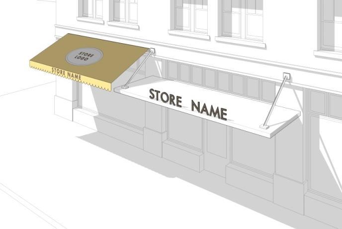
Sign, Freestanding
A permanently affixed sign that is wholly independent of a building for support and is attached along its entire width to a continuous pedestal. See example below. Design, materials, color, and content not regulated.
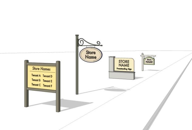
Sign, Monument
A ground sign generally having a low profile with little or no open space between the ground and the sign and having a structure constructed of masonry, wood, or materials similar in appearance. See example below. Design, materials, color, and content not regulated.
GLOSSARY OF TERMS AND PHRASES

GLOSSARY OF TERMS AND PHRASES
Sign, Projecting
A sign mounted perpendicular to and extending more than 1 foot from a building facade (similar to a bracket sign). See example below. Design, materials, color, and content not regulated.
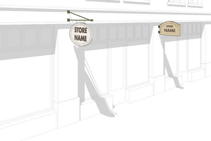
Sign, Sandwich Board
A portable and temporary sign that is ordinarily in the shape of an "A" with back to back sign faces, an easel, or a similar configuration. This sign type is typically used to announce daily specials, sales, or point to shops off the sidewalk. See example below. Design, materials, color, and content not regulated.

GLOSSARY OF TERMS AND PHRASES
Sign, Wall
A sign that is flat against the façade consisting of individual cut letters applied directly to the building, or painted directly on the surface of the building. See example below. Design, materials, color, and content not regulated.

Single-Family Dwelling
A building or structure designed or used exclusively for residence purposes by one household; each dwelling being separated by open space or yards.
Shopfront
The portion of a frontage composed of the display window and/or entrance and its components, including windows, doors, transoms and sill pane that is inserted into various frontage types, such as a shopfront or gallery, to accommodate retail uses.
Site
The parcel of land being developed, or a designated planning area in which the land development project is located and on which one occupied Recreational Vehicle may be legally maintained in an approved camp site as part of a Commercial Recreational Facility.
Site Plan, Major
An application for development on a commercial/industrial lot, or as required in these regulations, consisting of new development, additions over 5,000 square feet and/or 10 new parking spaces, or as otherwise required by the Commission.
Site Plan, Minor
An application involving any development on a commercial/industrial lot or as defined in these regulations, not rising to the level of a Site Plan, Major.
Soil
Any unconsolidated material or organic material of any origin.
GLOSSARY OF TERMS AND PHRASES
Soil Erosion and Sediment Plan
A scheme that minimizes soil erosion and sedimentation resulting from development and includes, but is not limited to, a map and narrative.
Solar Array
A special structure comprised of one or more solar panels that produce electricity for the principal use of the lot on which the solar electric system is located, but does not include solar panels affixed to a roof of a building. See Special Regulations: Wind and Solar Facilities.
Special Permit / Exception
Special Permits and Exceptions are utilized to allow certain uses or activities that require a higher lever of scrutiny. Special Permit applications are heard by the Planning and Zoning Commission, Special Exceptions are heard by the Zoning Board of Appeals. Both shall utilize the Special Permit requirements of section III.J., as well as any other applicable sections, of these regulations.
Special Structure
Special structures are communications facilities, solar array, and windmills.
Specified Anatomical Areas
Means less than completely and opaquely covered:
1. Human genitals, pubic region;
2. Buttocks;
3. Female breasts below a point immediately above the top of the and areola; or
4. Human male genitals in a discernibly turgid state even if completely covered.
Specified Sexual Activities
Means:
1. Human genitals in a state of sexual stimulation or arousal;
2. Acts of human masturbation, sexual intercourse, or sodomy; or
3. Fondling or erotic touching of human genitals, pubic region, buttocks or female breasts.
Stable, Commercial
A stable where horses are kept for profit or gain, including, but not limited to, boarding horses, riding instruction or renting of horses.
Stable, Personal
A stable used solely for horses owned by the resident occupant, except that occasional and temporary boarding of horses not for gain, direct or indirect is permissible.
Storage Business, Outdoor Limited
The storage of materials outside of a structure other than fencing, either as an accessory or primary use.
Storage, Personal and Mini-Warehouse
Structures containing generally small, individual, compartmentalized stalls or lockers rented as individual storage spaces and characterized by low parking demand.
Storage Tank
A stationary device which is designed to store hazardous materials, and is constructed of non-earthen materials including without limitation concrete, steel, fiberglass or plastic.
GLOSSARY OF TERMS AND PHRASES
Street
A public thoroughfare more than ten feet in width which has been dedicated to the public for public use and which affords principal means of access to abutting lot.
Street Line
A lot line dividing a lot from an abutting street, private way or alley way.
Structure
A structure is anything constructed or erected which requires location on the ground or attached to something having a location on the ground.
Subdivision
The division of a tract or parcel of land into three or more parts or lots made subsequent to the effective date of subdivision Regulations for the purpose, whether immediate or future, of sale or building development expressly excluding development for municipal, conservation, or agricultural purposes, and including resubdivision.
Substantial Improvement
Any combination of repairs, reconstruction, alteration, or improvements to a structure taking place over a 10- year period, in which the cumulative cost equals or exceeds fifty percent of the market value of the structure. The market value of the structure should be either the appraised value of the structure prior to the start of the initial repair or improvement, or in the case of damage, the value of the structure prior to the damage occurring. For the purposes of this definition, a substantial improvement is considered to occur when the first alteration of any wall, ceiling, floor, or other structural part of the building commences, whether or not that alteration affects the external dimensions of the structure. The term does not, however, include any project for improvement of a structure required to comply with existing health, sanitary, or safety code specifications which are solely necessary to assure safe living conditions.
Swimming Pool
Any indoor or outdoor accessory structure intended for swimming, wading or recreational bathing, which may be constructed, installed or located in-ground, partially in-ground and may include permanent or storable swimming pools, hot tubs and spas.
T
Tap/Tasting Room
A room or Outdoor Tasting area that is ancillary to the production of beer and malt beverages or alcoholic beverages at a microbrewery, brewpub, large brewery or distillery where the public can purchase and/or consume only the alcohol products produced on site and ancillary sales of retail merchandise.
Taverns
A place retail sale of beer and of cider not exceeding six per cent of alcohol by volume and wine to be consumed on the premises of a tavern with or without the sale of food. “Tavern” means a place where beer and wine are sold under a tavern permit
Terrace
A surfaced area adjacent to a building which serves as an outdoor extension of the use of that building, which is open both vertically and horizontally, and which does not exceed a height of eight (8) inches (.67 feet) above the average grade taken adjacent to all sides of the structure.
Tower
A support structure intended to support antennas and associated equipment, including a Guyed Tower, Lattice Tower and Monopole Tower.
Town
Shall mean the Town of Winchester.
Town Planner
The planner employed by the Town or under contract by the Town to perform planning and zoning services, but not the Zoning Enforcement Officer. In the event that the Town does not have a Town Planner, the Town Manager shall be deemed to be the Town Planner for all purposes hereof.
Townhouse
A building containing multiple single-family dwellings being separated horizontally by fire resistive walls without openings and each having independent access to the exterior of the buildings on the ground story.
Traditional Home Enterprise
An accessory use of a dwelling involving the creation and sale of home-made arts, crafts and goods which by the nature of the activity will generate only a very low level of foot or vehicular traffic.
Trailer, Construction
A vehicle which can be drawn or be carried on a motor vehicle, whether on temporary or permanent supports. Trailers used for business, office, and storage purposes in connection with a bonafide construction operation within the Town may be used for such purposes in any district for a period of time not to exceed the duration of the construction contract.
U
Unattended Donation Containers
Any unattended container, bin, box or similar receptacle that is located on any lot within the Town that is used for soliciting and collecting donations of clothing or other salvageable personal property. This term does not include recycle bins for the collection of recyclable material, similar to a trash container or dumpster, governed or regulated by the zoning regulations or any unattended donation box not located within a building.
Underground
A structure or structure component which is below the surface of the ground or is not fully visible for inspection. Facilities which are not considered to be underground include tanks and piping in underground areas such as basements, cellars, shafts, tunnels or vaults with manned access.
GLOSSARY OF TERMS AND PHRASES
Usable Site Area
Land other than regulated inland wetlands and watercourses, 100 year flood hazard areas as defined by the Federal Emergency Management Agency and as shown on Flood Hazard Areas Maps on file in the office of the Commission, land subject to existing easements which prohibit building or development, and 50% of all land with a slope in excess of 25% as delineated on a site plan map showing topographic contours based upon a field or aerial survey and certified by a Connecticut licensed surveyor.
Use
The specific purpose for which land or a building is designed, arranged, intended, or for which it is or may be occupied and maintained. The term "permitted use" or its equivalent shall not be deemed to include any non-conforming use.
V Vehicle
A “vessel” as defined by §15-170 of the Connecticut General Statutes, which means every description of watercraft, other than a seaplane on water, used or capable of being used as a means of transportation on land or water, and any vehicle propelled or drawn by any non-muscular power, including without limitation an automobile, aircraft, all-terrain vehicle or snowmobile.
Vehicle Sales and Service, Personal
A facility for the sale or rental of automobiles, motorcycles and pickup trucks and vans and accessories therefor, including storage and incidental maintenance and repair and maintenance.
Vehicle Sales and Service, Pleasure
A facility for the sale or rental of motor homes, recreational vehicles and campers, boats and personal watercraft, and similar equipment and accessories therefor, including storage and incidental maintenance and repair.
Vehicle Sales and Service, Professional
A facility for the sale or rental of tractors, construction or agricultural equipment, semi-trucks and trailers and similar equipment and accessories therefor, including storage and incidental maintenance and repair.
Vehicular
See Vehicle.
Veterinary Hospital
A building for the medical and/or surgical care of sick or injured animals.
W
Warehouse, Large
A facility for the storage of commercial goods within an enclosed building for distribution by truck, including, but not limited to, bulk mail handling facilities, larger than 20,000 square feet in gross floor area.
OF TERMS AND PHRASES
Warehouse, Small
A facility for the storage of commercial goods within an enclosed building for distribution by truck, including, but not limited to, bulk mail handling facilities, no larger than 20,000 square feet in gross floor area.
Water Pollution
An activity having a harmful thermal effect on or contaminating or rendering unclean or impure any waters, including groundwater of the state by reason of any waste or other materials discharged or deposited therein by any public or private sewer or otherwise so as directly or indirectly to come in contact with any waters.
Water Surface Elevation
The height, in relation to the National Geodetic Vertical Datum (NGVD) of 1929, (or other datum, where specified) of floods of various magnitudes and frequencies in the floodplains of coastal or riverine areas.
Waters
As defined in §22a-423 of the Connecticut General Statutes means all rivers, brooks, watercourses, waterways, wells, springs, lakes, ponds, marshes, drainage systems and all other surface or underground streams, bodies or accumulations of water, natural or artificial, public or private, which are contained within, flow through or border upon this Town or any portion thereof.
Wholesale and Distribution Business
A facility for storage and wholesale distribution of merchandise and bulk goods and nonretail store sales, including electronic shopping, mail-order houses and other direct-selling establishments. This use classification excludes retail sale of goods at discount prices for individual consumption.
Windmill
A special structure that captures kinetic energy from the wind to drive an electrical generator with typical components including blades, a tower, and an accelerator platform or nacelle body. See Special Regulations: Wind and Solar Facilities.
Worship Place
An establishment for religious worship and other religious ceremonies, including accessory religious education, rectories and parsonages, offices, social services, columbaria and community programs.
Y Yard
The area between the interior setback line on a lot and a lot line. See below.
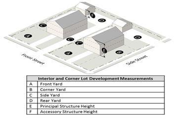
Yard, Front
A space extending across the full width of a lot between the front lot line and the front of a principal building.
Yard, Minimum Front
An open space extending the full width of the lot between a front lot line and the building line. Rear lots shall have a minimum front yard requirement measured from any front lot line parallel to any street from which the rear lot gains access. All Tables in these Regulations indicating front yard requirements shall mean minimum front yard requirements.
Yard, Minimum Rear
An open space extending across the full width of the lot between the rear lot line and a parallel line within the lot set back a distance equal to the minimum rear yard requirements. On a lot with no rear yard, the side yard shall extend to the opposite lot line. All Tables indicating rear lot requirements shall mean the minimum rear yard requirements.
Yard, Minimum Side
An open space extending from the front lot line to the rear lot line between the side lot line and a parallel line set back within the lot a distance equal to the minimum side yard requirement. On a lot with no rear yard, the side yard shall extend to the opposite lot line. All Tables in these Regulations indicting side yard requirements shall mean minimum side yard requirements.
Yard, Rear
A space extending across the full width of the lot between the rear lot line and the rear of the principal building.
Yard, Side
A space extending for the full depth of a lot between any side lot line and the side of the principal building.
ZBA (Zoning Board of Appeals)
As per the CGS§ 8.1 et seq., A Town Board whose responsibilities include hearing appeals, varying the zoning regulations and approving certain permits. See appendix B.
ZEO – see Zoning Enforcement Officer
Zoning Enforcement Officer
One or more employees of the Town, or his/her designee(s), who shall hereby be authorized to inspect premises regulated under this regulation and to take the required actions authorized by this regulation in case of violations being found on such premises, and to require corrections of unsatisfactory conditions found on said premises;
Zoning Map, Official
The Town of Winchester Planning and Zoning Commission Official Zoning Map showing zoning districts prepared in accordance with maps adopted pursuant to §8-3 of the Connecticut General Statutes.
GLOSSARY OF TERMS AND PHRASES
APPENDIX A - TABLE OF USES AND MINIMUM PARKING REQUIREMENTS
P – Permitted SP - Special Permit Required Blank Box – Not Permitted
* Notwithstanding the off-street parking requirements by use set forth in the table above, no off-street parking is required for any uses in the TC district.
APPENDIX B - ZONING BOARD OF APPEALS
1. Establishment. There shall be a zoning board of appeals pursuant to the provisions of C.G.S. Chapter 124 (C.G.S. Sections 8-1, et seq.).
2. Powers and duties. The zoning board of appeals shall have the following powers and duties:
a. Appeals. To hear and decide appeals where it is alleged that there is an error in any order, requirement or decision made by the official charged with the enforcement of these regulations.
b. Variances. To determine and vary the application of these regulations in harmony with their general purpose and intent, and with due consideration for conserving the public health, safety, convenience, welfare and property values solely with respect to a parcel of land where owing to conditions especially affecting such parcel but not generally affecting the district in which it is situated, a literal enforcement of such regulations would result in exceptional difficulty or unusual hardship so that substantial justice will be done and public safety and welfare secured.
No variance shall be granted by the zoning board of appeals unless it finds the following:
i. The variance would be in harmony with the purposes of these regulations, as set forth in section 1.2 of these regulations;
ii. The literal enforcement of these regulations would result in unusual hardship, as the same has been defined by the courts of the state of Connecticut and as summarized:
iii. The hardship recognized by the law is that of the property, due to its unique shape, topography, or other inherent condition; the personal hardship of the owner, such as age or family condition, is not a legal hardship which would support the granting of a variance; except to the extent required by the Americans with Disabilities Act.
iv. The hardship must not be merely financial, such as that the owner would make more money or lose less money if the variance were granted, as financial hardship is personal, and not inherent in the property itself.
v. The hardship must be unique to the property, in the sense that it is a characteristic which is not exhibited by other properties in the area or in the district, and which makes it appropriate for special treatment. Merely being too small or too narrow is not a legal hardship unless it restricts the property from being put to a reasonable use permitted in the subject district.
vi. The hardship must not be created by the owner or his/her predecessor in title, such as by dividing a parcel to create lots which cannot support the desired use; or creating a topographic condition by excavation, fill, or other measures which render the property unusable for its highest use without a variance; or by building a structure which, for whatever reason, violates a current zoning regulation.
vii. In accordance with Connecticut case law, the board is prohibited from varying any condition or requirement set forth in these regulations for a special exception use, such uses being permitted in the subject district only when all conditions or requirements contained here are satisfied.
viii. The burden is on the applicant to demonstrate that the requirements for a variance have been met.
ix. Variances are to be granted sparingly, and only to the minimum extent necessary to allow property to be used for the least intense use which is permitted in the subject district.
c. Use Variance. No use variance shall be granted merely because the permitted uses result in a particular difficultly or provide less that the highest and best return to the owner. The Zoning Board of Appeals may, upon application by the owner, grant variances authorizing otherwise prohibited uses if the applicant makes an affirmative showing that:
i. A dimensional variance will not relieve the exceptional difficultly or hardship;
ii. In view of the available alternatives, the public interest would be best served by permitting such use at the proposed location; and
iii. The public interest cannot reasonably be served by location of such use in a district in which it is permitted.
d. Other Duties. The Zoning Board of Appeals shall hear and decide all matters referred to it and upon which it shall be required to pass under any provision of these regulations or the C.G.S.
APPENDIX C - ZONING MAP
The boundaries of districts established hereunder are shown on certain maps entitled, “Zoning Map City of Winsted Winchester Connecticut Scale 1” = 1600 ft. Map 1 of 2” and “Zoning Map Winchester Central Business District Winchester Connecticut Scale 1” = 800 ft. Map 2 of 2,” both approved November 7, 2016, as now or hereafter amended, referred to in these Regulations as the “Official Zoning Map” or “Zoning Maps.” The Official Zoning Map is hereby declared part of these Regulations. When, in accordance with the provisions of these Regulations, changes are made in district boundaries or other matters portrayed on the Official Zoning Map, such changes shall be made on the Official Zoning Map together with an entry on the Official Zoning Map, in the “Revision” block, indicating the revision number, the designation of the old zone, the designation of the new zone, the effective date of the revision and the initials of the Chairman of the Commission. The Official Zoning Map shall be filed in the Office of the Town Clerk and an updated copy shall be displayed in the office of the Commission.
Amended July 24, 2017
APPENDIX D – TABLE OF APPLICATIONS AND PERMITS
APPENDIX D - TABLE OF APPLICATIONS AND PERMITS
APPENDIX E - TABLE OF AMENDMENTS
These Regulations were amended and restated in their entirety and made effective as of November 7, 2016. These Regulations supersede and replace all prior zoning Regulations, and the amendments listed below are only those made after the effective date of these Regulations:
July 24, 2017
INDEX
above ground 112, 120
accessory apartment 5, 7, 8, 10, 11, 64, 65, 112, 123, 147
accessory building, structure or use.....................................112
accessory residential uses 5, 6, 7, 8, 10, 11, 112, 147
adequate capacity 101, 112
adequate coverage 101, 102, 113
adult amusement machine 112, 113
adult bookstore 112, 113
adult entertainment 66, 113
adult mini-motion picture theater 113
adult motion picture theater 113
adult-oriented establishment 9, 66, 67, 113, 120, 131, 147
affordable housing (town sponsored/local non-profit) 113
alter, alteration....................................................................113
antenna 98, 100, 101, 102, 105, 114, 131
artisan production 7, 8, 9, 114, 147
average natural grade ......................................................3, 114
bakery 7, 8, 9, 114, 135, 147
banquet facility 7, 8, 10, 15, 85, 87, 114, 147
barn................................................................................86, 114
base flood 115, 128
basement 90, 115, 118, 123
bed and breakfast...........................................................68, 119
best management practice 19, 21, 35, 115
better site design 21, 115
brewery, large 7, 8, 9, 115, 147 brewery, micro- 115
brewpub 7, 8, 9, 15, 115, 142, 147
building 3, 4, 5, 6, 7, 8, 9, 10, 11, 12, 13, 15, 16, 17, 18, 23, 24, 25, 26, 28, 31, 34, 38, 43, 44, 46, 48, 60, 61, 62, 63, 64, 65, 66, 67, 69, 70, 71, 74, 77, 79, 80, 83, 86, 88, 89, 91, 92, 93, 94, 95, 97, 101, 102, 103, 105, 110, 112, 113, 114, 115, 116, 117,118, 119, 120, 121, 122, 123, 124, 125, 126, 127, 129, 130, 132, 133, 134, 135, 138, 139, 140, 141, 142, 143, 144, 145, 151
building area 60, 114, 116
building height 6, 12, 24, 25, 116
building line 79, 127, 145
bulk storage facility 9, 116, 147
c.g.s. 1, 2, 54, 58, 61, 62, 98, 109, 117, 121, 151, 152
car wash 8, 9, 117, 148 carrier 104, 105, 108, 109, 117, 136
cemetery ................................ 5, 6, 7, 8, 9, 10, 11, 66, 117, 148 certification 52, 54, 72, 117 clear-cutting 29, 117 club 5, 7, 8, 10, 11, 15, 69, 71, 74, 117, 133, 134, 148
cold storage plant 117 college 7, 8, 117, 148 co-location 102, 104, 107, 108, 109, 117 commencement 23, 24, 118 commissary 7, 8, 9, 118, 148 commission3, 12, 13, 16, 19, 21, 23, 24, 25, 28, 29, 30, 31, 33, 34, 35, 36, 39, 40, 45, 50, 51, 52, 54, 55, 56, 57, 58, 59, 60, 61, 62, 63, 66, 69, 70, 71, 72, 73, 74, 75, 81, 82, 83, 84, 86, 91, 92, 93, 94, 95, 97, 99, 102, 104, 105, 106, 107, 108, 109, 110, 111,117, 118, 120, 121, 125, 140, 143, 146, 153 communications facilities 118, 141 community center, private 6, 8, 9, 118, 148 construction trailer 118 container 35, 77, 94, 118, 132, 143 continuing care retirement community 6, 7, 8, 118, 148 convalescent home/nursing home 6, 7, 8, 11, 78, 118, 148 country inn 5, 6, 7, 8, 10, 11, 15, 80, 118, 148 county soil & water conservation district 54, 117, 118, 120 cultural institution 7, 8, 119, 148 demolished 26, 27, 119 development 1, 2, 3, 5, 6, 7, 8, 9, 11, 12, 15, 16, 19, 20, 21, 22, 27, 28, 29, 34, 35, 37, 45, 49, 50, 52, 53, 54, 56, 57, 58, 59, 70, 76, 81, 91, 92, 94, 95, 100, 102, 104, 106, 107, 116, 119, 126, 134, 140, 142, 143, 149 distillery....................................................7, 8, 9, 119, 142, 148 disturbed area 52, 83, 119 driveway 5, 10, 31, 32, 33, 38, 39, 73, 78, 81, 119, 122, 137 drug store, large format............................................8, 119, 148 drug store, small format 7, 8, 119, 148 dustless surface (permanent surfaces) 119 dustless surface (temporary surfaces) 119 dwelling 5, 6, 25, 28, 29, 39, 51, 64, 65, 70, 76, 85, 87, 88, 90, 91, 94, 99, 104, 112, 115, 119, 120, 121, 123, 124, 129, 133, 134, 136, 140, 143, 147, 150
dwelling unit 6, 25, 28, 29, 39, 64, 65, 76, 94, 112, 120, 123, 124, 129, 147
dwelling, congregate 120
dwelling, multi-family 120
dwelling, one family 120
dwelling, single-family 120
dwelling, two family (duplex)
120
elevation 20, 82, 101, 103, 120, 122
employee 117, 120 enforcement officer, inland wetland 120
entertainer 113, 120
equipment shelter 103, 104, 105, 106, 108, 111, 121
erosion 2, 29, 35, 52, 53, 54, 83, 117, 119, 121, 125, 136, 140
fall district 104, 121
family day care home 5, 6, 7, 8, 9, 10, 11, 15, 46, 49, 50, 121, 124, 148
farm 8, 9, 10, 11, 41, 50, 85, 86, 87, 112, 114, 116, 121, 122, 148
farm stand, permanent 8, 9, 10, 121, 148
farm winery 8, 10, 11, 87, 121, 148 farming 41, 121, 122
finished grade 122
flood control 122
flood insurance rate map 122, 128 flooding 114, 122
front façade 79, 122, 127
grading 52, 53, 78, 81, 83, 105, 108, 111, 114, 119, 122 green space 122, 133
greenhouse/nursery, commercial 8, 10, 88, 122, 148
gross floor area 64, 119, 123, 135, 144, 147
ground mounted tower 101, 102, 103, 104, 106, 109, 123 groundwater 2, 19, 20, 74, 123, 125, 131, 144
group day care home 5, 7, 8, 10, 122, 148
guyed tower 123, 142
habitable floor area 80, 123, 133
hazardous materials 74, 103, 123, 127, 135, 141
hazardous waste 103, 123
home farming 5, 7, 8, 10, 11, 50, 89, 123, 148 home occupation........................5, 6, 7, 8, 10, 11, 90, 124, 148 hospital 7, 8, 66, 124, 128, 148 hotel 7, 8, 10, 15, 119, 124, 148 household.........................................25, 90, 120, 124, 132, 140
impermeable 124
impervious surface 5, 6, 8, 9, 10, 11, 12, 15, 20, 26, 80, 124 independent living retirement facility 7, 8, 125, 148 industrial heritage re-use 7, 8, 91, 125, 148 industrial laundry 9, 125, 148 infiltration 20, 125 inspection 21, 54, 62, 66, 112, 125, 143 junkyard 125, 148 kennel 8, 9, 10, 125, 148 laboratory 9, 125, 149 landscaped area.................................................36, 38, 39, 125 landscaped buffer 37, 39, 126 lattice tower 109, 123, 126, 142 licensed carrier.....................................................104, 108, 126 lot 1, 3, 5, 6, 8, 9, 10, 11, 12, 13, 15, 24, 25, 26, 28, 29, 30, 31, 32, 33, 34, 35, 36, 37, 38, 39, 42, 43, 44, 46, 48, 50, 60, 61, 63, 64, 71, 74, 75, 76, 77, 78, 79, 80, 81, 85, 87, 88, 89, 90, 94, 95, 98, 104, 105, 110, 111, 112, 114, 115, 116, 117, 118,119, 120, 121, 122, 123, 125, 126, 127, 128, 130, 131, 132, 135, 136, 140, 141, 142, 143, 145, 146
lot area 3, 6, 9, 10, 11, 15, 25, 28, 78, 80, 95, 126 lot coverage 78, 126 lot depth..............................................................................126
lot line 3, 13, 31, 36, 37, 44, 74, 78, 79, 80, 89, 94, 105, 110, 126, 127, 136, 142, 145, 146 lot line, front 127 lot line, rear.........................................................................127 lot line, side 127 lot, corner 126 lot, frontage 126 lot, rear 126 lot, through 127 lot, vacant 127 maintenance shed 112, 127 manufactured home 5, 10, 128, 149 manufacturing, heavy 9, 127, 149 manufacturing, light 7, 8, 9, 127, 149 mean sea level.....................................................103, 120, 128 medical marijuana dispensary facility 7, 8, 9, 93, 128, 149 medical marijuana production facility 9, 128, 149 metal waste salvage yard..................................................128 minor 50, 68, 72, 129 mixed-use building 6, 7, 8, 31, 129, 149 mobile home.................................................................128, 129 monopole tower 100, 104, 129, 142
motor vehicle fuel sales 7, 8, 9, 46, 129, 149
mount 102, 105, 106, 108, 117, 121, 126, 129
multi-family dwelling 6, 7, 8, 39, 94, 123, 129, 149
municipal building
129 municipality 129, 132 new construction 99, 130
non-conforming lot 25, 121, 130
non-conforming situation 130
NON-CONFORMING USE 23, 24, 50, 61, 62, 130, 143
nonpoint source pollution.................................................130
offices, business 130
offices, professional 130, 131
open space......1, 2, 5, 10, 14, 28, 39, 60, 73, 94, 95, 126, 131, 138, 140, 145, 146, 149
open space subdivision 5, 10, 14, 28, 95, 131, 149 operator 67, 81, 82, 83, 84, 99, 131 owner.13, 21, 33, 34, 36, 58, 61, 64, 65, 67, 68, 81, 82, 83, 84, 94, 99, 111, 116, 117, 118, 131, 151, 152
panel antenna 129, 131 parapet 131
parking area 31, 33, 37, 38, 39, 42, 50, 70, 78, 80, 88, 94, 106, 131, 137
parking space 31, 32, 33, 34, 37, 38, 50, 51, 65, 74, 77, 86, 88, 92, 94, 131, 140
patio
132
person 29, 59, 60, 63, 66, 67, 120, 124, 128, 129, 131, 132, 133, 137
pervious surface
132
plot plan 60, 132
point source 19, 132
pool house 112, 132
principal building 5, 10, 14, 33, 40, 112, 126, 132, 145, 146
principal use...........................71, 110, 130, 132, 133, 134, 141
public recreation facility 5, 6, 7, 8, 9, 10, 11, 15, 133, 149
public safety facility 5, 6, 7, 8, 9, 10, 11, 97, 133, 149
public utility facility..................5, 6, 7, 8, 9, 10, 11, 98, 133, 149
recharge 19, 20, 125, 131, 133
recreation 5, 6, 7, 8, 9, 10, 11, 15, 70, 71, 72, 94, 95, 133, 134, 148, 149
recreation facility, commercial..........................................134
recreational vehicle 129, 134, 144
recycling facility 9, 134, 149
regulated facility ..100, 101, 102, 103, 104, 105, 106, 107, 108, 109, 134
restaurant 6, 7, 8, 15, 114, 115, 118, 134, 135, 149
restaurant, high turnover/fast food
135 resubdivision 3, 135, 142
retail, convenience 8, 15, 135, 149 retail, grocery large format 8, 135, 150 retail, grocery small format 7, 8, 15, 135, 150 retail, large shop 8, 135, 150 retail, personal services 135 retail, small shop 7, 8, 15, 136, 150 runoff 11, 19, 20, 35, 52, 53, 125, 130, 132, 136 school....................... 1, 5, 6, 7, 8, 10, 11, 66, 93, 117, 136, 150 screening 14, 37, 40, 81, 83, 100, 136 seasonal cottage 10, 11, 50, 119, 136, 150 security barrier .....................................103, 105, 106, 108, 136 sediment 52, 53, 54, 117, 125, 136, 140 separation 37, 69, 97, 136 setback, front 136 setback, rear 136 setback, side
sexual activities 112, 137 shopfront
shopping center
sign 5, 6, 7, 8, 9, 10, 11, 15, 42, 43, 44, 45, 46, 48, 49, 51, 60, 61, 63, 66, 71, 85, 87, 99, 137, 138, 139, 140 sign, awning
sign, freestanding
sign, monument
sign, projecting
sign, sandwich board ........................................................139 sign, wall
single-family dwelling 8, 10, 11, 19, 52, 64, 120, 123, 140, 143, 150 site13, 16, 17, 19, 20, 22, 26, 29, 31, 32, 33, 34, 35, 36, 40, 42, 45, 46, 48, 50, 51, 52, 53, 54, 55, 56, 57, 58, 60, 62, 69, 70, 71, 72, 73, 78, 82, 85, 86, 92, 94, 95, 97, 98, 99, 101, 102, 103, 104, 105, 106, 107, 108, 109, 111, 115, 116, 117, 118, 119, 120, 125, 126, 129, 134, 136, 140, 142, 143 site plan, major...............................................................50, 140 site plan, minor 50, 140 soil 2, 20, 35, 52, 53, 54, 83, 96, 117, 121, 123, 124, 140 solar array............................................................110, 111, 141 special structure 141, 145 specified anatomical areas 66, 112, 113, 141 specified sexual activities...............................66, 112, 113, 141 stable, commercial 8, 9, 10, 141, 150
stable, personal 141
storage business, outdoor limited 8, 141, 150 storage tank 141
street 4, 5, 6, 7, 8, 9, 10, 11, 15, 28, 31, 32, 33, 34, 35, 38, 39, 42, 43, 50, 51, 65, 67, 73, 74, 78, 79, 82, 83, 84, 85, 86, 88, 90, 94, 99, 104, 116, 124, 125, 126, 127, 131, 135, 137, 141, 142, 145, 147, 148, 149, 150
street line.....4, 38, 39, 43, 79, 82, 83, 85, 86, 88, 94, 126, 127, 142
structure 3, 14, 16, 23, 24, 25, 26, 27, 31, 35, 46, 48, 60, 61, 63, 64, 65, 68, 69, 70, 79, 80, 81, 93, 94, 97, 99, 100, 101, 102, 104, 109, 110, 112, 113, 114, 115, 116, 117, 118, 119, 120, 121, 123, 124, 127, 129, 130, 131, 132, 136, 137, 138, 140, 141, 142, 143, 151
subdivision 3, 14, 19, 21, 25, 28, 39, 52, 95, 132, 135, 142 substantial improvement 142 swimming pool..............................................112, 132, 133, 142 tap/tasting room 7, 8, 9, 15, 142, 150 terrace 39, 132, 142 tower 100, 101, 102, 104, 116, 123, 129, 142, 145
town 1, 2, 3, 4, 5, 7, 8, 9, 10, 16, 19, 21, 24, 25, 28, 29, 32, 33, 34, 35, 37, 39, 48, 54, 58, 59, 60, 61, 62, 65, 66, 73, 77, 78, 82, 83, 100, 101, 102, 104, 105, 106, 107, 109, 111, 116, 117, 118, 120, 127, 129, 133, 142, 143, 145, 146, 147, 153 town planner 16, 143 townhouse 143
traditional home enterprise 124, 143 trailer 118, 129, 140, 143 trailer park 129 trailer, construction 118, 143 unattended donation containers 41, 143
underground 17, 133, 143, 145 usable site area 25, 94, 143 use 1, 2, 3, 5, 6, 7, 16, 20, 21, 23, 24, 25, 28, 30, 31, 33, 34, 35, 37, 39, 42, 44, 46, 49, 50, 51, 56, 57, 58, 60, 61, 62, 63, 64, 65, 66, 67, 68, 69, 70, 71, 73, 74, 76, 80, 82, 85, 88, 90, 91, 92, 95, 97, 99, 100, 101, 102, 104, 105, 106, 107, 108, 110, 111, 112, 113, 114, 115, 116, 117, 121, 122, 123, 124, 125, 128, 130, 132, 133, 134, 135, 136, 137, 141, 142, 143, 145, 149, 150, 151, 152 vehicle 8, 9, 31, 38, 57, 117, 131, 134, 143, 144, 150 vehicular 32, 33, 56, 74, 119, 125, 143, 144 veterinary hospital 8, 9, 10, 144, 150 warehouse, large 8, 9, 144, 150 warehouse, small 8, 9, 144, 150 water pollution 74, 144 water surface elevation 144 waters 2, 3, 144, 145 windmill 110, 111, 145 worship place 5, 6, 8, 9, 10, 145, 150 yard..5, 6, 7, 10, 13, 14, 36, 37, 39, 51, 73, 79, 88, 98, 99, 110, 116, 119, 125, 127, 128, 133, 145, 146 yard, front 145 yard, minimum front 145 yard, minimum rear
yard, minimum side
yard, rear
yard, side
zoning enforcement officer 3, 29, 33, 39, 45, 46, 52, 53, 60, 61, 62, 63, 64, 65, 66, 67, 81, 83, 93, 117, 143, 146 zoning map, official 146