EXISTING ZONING CODE DIAGNOSTIC REPORT
“The development of a Diagnostic Report is the first step in rewriting the City’s Zoning Ordinance, and a major step in implementing the City’s plans. This report provides guidance by reviewing and analyzing the consistency of the existing Zoning Ordinance with the land use goals of the Comprehensive Plan.”


EXECUTIVE SUMMARY
The zoning code is a critical tool for supporting and encouraging the built environment that Sun Prairie desires. Zoning significantly affects where people can or cannot live, find food, own land, start businesses, raise children, age in place, find employment, and seek education, among other pursuits of happiness. Although they may have celebrated features and beneficial intentions:
Zoning codes are only as good as the outcomes they produce.
Our analysis of the Sun Prairie zoning code and its adopted plans and policies indicate several substantive opportunities:
Objective A: The city has adopted plans and policies that serve as a guide for the values, design qualities, and built environment the community desires. The city can utilize best practices in development codes to create a new code consistent with these policies.
Objective B: Enable balanced neighborhoods with desirable design. Additional housing opportunities can open up incremental changes to established neighborhoods that have multi-faceted benefits of helping aging households downsize in place, meeting the preferences and needs of a wider diversity of households, raising property values, supporting affordability of properties, and creating fine-grained housing opportunities closer to businesses and employment opportunities in Sun Prairie. Several neighborhoods with mixed housing types have been permitted and constructed as Planned Developments, reflecting the community’s desire for these places.

Objective C: Decision making criteria and other standards should be created so that they are clear, objective, and measurable – in turn, empowering professional staff to review proposed investments in Sun Prairie that clearly meet plainly stated standards. The code can be more concisely and consistently organized to improve user friendliness and administrative efficiency. Clear standards provide improved certainty for property owners, city officials, and the public regarding expected outcomes.
Objective D: Manage rapid, regional growth. Sun Prairie is experiencing redevelopment of older properties, as well as adding new development of farmlands and natural areas around its periphery. The city has several areas where redevelopment is desired, as well as where new greenfield development is anticipated. The new code must be effective in accommodating investment in existing neighborhoods, redevelopment at various scales, and new neighborhoods with desirable design conditions. With regional growth expected to continue, improvements in the city’s codes can guide investment in ways consistent with the community’s vision.
Objective E: Focus on fairness and just outcomes. The policies and rules that govern changes in the built environment can have disproportionate impact based upon race and class. Some of the standards and procedures currently used in Sun Prairie are likely to create artificial barriers to health and property along these lines. A comprehensive update of the code is the opportunity to address these provisions and focus on inclusive processes and equitable outcomes.
Objective F: Environmental stewardship. The built environment has strong effects on our impacts on the environment, from the amount of land consumed and distance we travel between places, to stormwater management and urban forestry. In addition, our climate is changing which is causing new stresses in the form of large precipitation events and other extreme weather. The code must be updated to account of reducing our impacts on the environment and to the climate, and to create a city more resilient to current and future conditions.
This report marks the beginning of the process for creating a new zoning code for the city. For Sun Prairie’s consideration, this report is intended to illustrate opportunities that will improve the regulatory landscape established by the zoning ordinance in alignment with the city’s adopted vision and goals. Decisions on the scope and content of the code are ultimately in the hands of the City Council. The considerations written here are subject to change as the project progresses. We present this report as a means of engaging the community to gather input and develop a zoning ordinance that creates outcomes consistent with the city’s vision and values.
PURPOSE OF A DIAGNOSTIC REPORT
The development of a Diagnostic Report is the first step in rewriting the City’s Zoning Ordinance as a major implementation step of the City’s Comprehensive Plan and other adopted plans. This Diagnostic Report illustrates the condition of the existing Zoning Ordinance and its alignment with outcomes described in adopted plans, identifies challenges and shortcomings in administration, and identifies existing regulations to be maintained. This Diagnostic Report also contains a summary of a review of Sun Prairie’s plans, studies, and policies that contain implications for the Zoning Ordinance rewrite. The main objective is to collect and understand the vision, values, and desirable outcomes for Sun Prairie’s built environment, verify this direction, and create parameters for the creation of a new code.
Many cities have zoning codes that are over a generation old and that do not reflect their adopted vision, nor support modern land uses, laws, and best practices. Sun Prairie’s Zoning Code, originally adopted in 1989, was analyzed by evaluating the extent to which the Zoning Code advances or serves as a barrier to the goals of the Comprehensive Plan (2019) and the city’s Strategic Plan (2019). Other recent plans and studies adopted by the City are also utilized as contextual recommendations, including area plans such as Sun Prairie Stronger (2020) and Central Main Street Corridor Plan (2018), Housing Study (2022) and Active Transportation Plan (2024). The outcomes of this analysis inform the comprehensive update of Sun Prairie’s Zoning Ordinance and Subdivision Regulations.
As the City begins the process of crafting a new, modern, and streamlined Zoning Code consistent with its goals and contemporary best practices, this report is an important step in illuminating the current regulatory conditions of the Zoning Code as they relate to adopted City policies.
It is important to distinguish between this report and the Comprehensive Plan.
The Comprehensive Plan is the result of a multi-year planning process that included community engagement, visioning, and goal setting. The goals and polices included in the Plan range from broad objectives like “create balanced neighborhoods” to precise directives such as “require bike parking in new developments.”
A Comprehensive Plan is adopted by the City Council and serves as a high-level roadmap to guide future decision-making. In contrast, a Zoning Code is codified into law and establishes regulations that, if not adhered to, constitute a violation of the law. Where adopted plans do not address specific coding language, the team will utilize best practices in zoning, land use planning, and zoning administration that are consistent with purpose and value statements to generate recommended provisions or areas for further analysis.
In many instances, communities will adopt a comprehensive plan or other policy following significant time and energy, but zoning regulations are overlooked or revised over time in a disjointed manner. This scenario leads to outdated, inconsistent, and disorganized zoning regulations that are cumbersome, intimidating, and costly for property owners and administrators alike, impeding planning goals and economic development. Regulations that fail to relate to promote the community’s vision, align with community values, result in adaptable and resilience places, and respond to existing development patterns erode the relevant of both the existing and planned built environment. Regulations that lose their relevance and effectiveness become barriers to community prosperity, and create or fail to prevent harms to the populace.
The community’s values are expressed through adopted policies and are strongly connected to how the community arranges its built environment. Zoning, therefore, is a values document; a critical and detail-
“The community’s values are expressed through adopted policies and are strongly connected to how the community arranges its built environment.”

oriented framework creating enforceable standards and procedures for how change management in the built environment works. Zoning can create direct and indirect barriers to realizing the community’s vision, often in ways that are unclear due to how removed these standards can appear to be from the outcome. Standards that make it more difficult to pursue the community vision should be reconsidered or removed.
GENERAL GUIDING PRINCIPLES: BEST PRACTICES IN LAND USE REGULATION
Zoning is a powerful tool to shape the built and natural environment. When reviewing Sun Prairie’s adopted policy documents, current ordinance, and ultimately the formulation of a new code, regulations are viewed through the lens of the community value statement in addition to the following principles.
1. Zoning should regulate only what needs to be regulated.
Zoning regulations should place limits on the use of land only when necessary to promote public welfare. Regulations that do not relate to public interests of health and safety may overstep the police power granted to governments and may not be legally defensible.
2. Zoning should respect both existing and desired development patterns.
Zoning regulations should relate to a community’s existing and desired development patterns and should foster conditions that align with community values. When regulations are out of context with existing or desired development patterns, land owners may need to apply for numerous discretionary approvals and variances for typical development projects, which increase the cost of investment in a community. Antiquated or burdensome zoning regulations may act as a disincentive to positive change and investment in the community consistent with its vision. Furthermore, unnecessary administrative processes and discretionary approvals create extra work that burden government departments and elected bodies.
3. Zoning should implement the plan, not be a barrier to achieving the vision.
community’s vision as expressed in its comprehensive plan and other adopted policy documents. Because zoning regulations are the implementation of a plan, the plan should lead, and the regulations follow. A zoning ordinance that is built from the community’s comprehensive plan utilizing tested best practices allows for clear, usable, defensible, and consistent regulations that operate effectively to protect the public interests and encourage desired outcomes.
4. Zoning should prioritize equity.
Zoning codes are complex and multidisciplinary legal documents, and given the ubiquity and power of zoning, there is relatively little research regarding all the myriad ways that zoning has contributed to segregation and differential access to opportunity within the United States. The research that does exist is conclusive in that many zoning regulations had biased motivations and result in new or reinforced harms to historically marginalized populations. Recognition of the disparate impacts of development regulations on racial inequality are growing. At a minimum, zoning has reduced the availability, affordability, and diversity of housing options in communities across the country and impeded investment in older and obsolete properties. Zoning has caused systemic inequitable public health outcomes by creating disproportionate transportation burdens, barriers in access to education, fresh food, public space, and healthcare, increased exposure to pollution, and other harms. However, these negative impacts are not isolated to underrepresented populations, these avoidable harms effect the wellbeing of everyone. All zoning amendment processes should explore and implement solutions for the direct and indirect ways zoning codes contribute to inequity.
Zoning should be a tool to implement a
GUIDING PRINCIPLES / PROJECT GOALS
The overarching goal of this zoning code rewrite project is to craft custom-tailored, clear, consistent, user-friendly, resilient, equitable, and defensible zoning regulations that advance the City’s quality-of-life vision. The new code should be streamlined, made more user-friendly and more effective at achieving the City’s desired outcomes. Sun Prairie is not a one-size-fits-all community, and its zoning regulations should not be one size fits all. The code should be consistent with current best practices, tailored to Sun Prairie.
ONE
Desired Outcomes and Characteristics of Success:
• Coherent system of modern local development regulation that clearly advances public health, safety, and welfare, aligned with city vision and values.
The Project and the Diagnosis proceeds from the framework described in the Request for Proposals that included an ambitious vision, goals, and benchmarks for how Sun Prairie’s development regulations should be arranged, what and how the code should regulate, and the intended and desired outcomes. This direction was confirmed through review and approval for the RFP by the Plan Commission and City Council.
The City seeks an ambitious and forwardthinking approach to development regulation that clearly reflects community values and is completely aligned with creating an equitable, sustainable, and prosperous city. The code must support sustainable city building through means such as compact development, mixeduse neighborhoods, efficient land use, limit automobile transportation needs, and utilize design practices that support natural systems. Regulatory tools that create or reinforce social and racial inequity or result in disparate impacts must be eliminated, and this new framework must advance equitable development to the extent possible. A public health lens must be utilized to reinforce positive environmental and social determinants of health through community design for all members of the community. Property owners will have greater flexibility and freedom to invest in their place. In addition, the code must allow and encourage greater housing diversity and livability through design and enabling regulations.
• Site and building design standards with form-based and performance criteria utilizing simple and clear illustrations or images to visually define standards and expectations.
• Enable neighborhoods with a mix of housing types, scales, and price points, accessible with jobs, services, and institutional uses.
• Conduct a robust and inclusive public process that successfully and meaningfully includes minority and underrepresented populations, that fairly and transparently addresses issues and solutions. Coding process that educates with evidencebased literature/data on the need for zoning reforms and the associated cobenefits, and utilizes effective messaging to combat myths, stereotypes, and harmful judgments attached with particular development formats.
• Reduce environmental impact and carbon emissions through land use, development, transportation, and linked factors. Site and landscaping standards that integrate low impact development, green infrastructure, and native, biodynamic landscapes.
• Modernize and streamline the entitlement process. Greatly reduce the use of planned development zoning, conditional uses, and discretionary hearings.
• Remove unnecessary regulatory barriers to infill development in existing neighborhoods.
• Integrate holistic public health considerations into built environment
regulations.
• Control the volume and location of automobile storage and drive-through uses to emphasize high design quality, walkability, and safety.
• Update and consider integration of land division ordinances with the zoning code rewrite.
• Eliminate exclusionary zoning practices that do not advance public health or welfare.
• Promote and affirmatively further the City’s commitment to equity, diversity, and inclusion, repositioning development regulations as a tool for pursuing equitable development.
• Update the sign ordinance to be consistent with latest case law and enabling of public art.
• Coordinate land use and transportation to create a connection-rich environment. Enable best practices in transit-oriented development and communities. Reinforce an intentional prioritization and transition toward pedestrian and bicycle mobility and transit access.
• Create an ordinance framework that is resilient with the capacity to create updates by staff. Incorporate timeless and flexible design requirements that allow the built environment to advance public interests and values while being flexible to changing technology and economy.
• Utilize zoning as a placemaking tool. The character of the built environment is significantly shaped by development regulations, resulting in the performance, appearance, enjoyment, flexibility, resiliency, seasonality of place. While modern development regulations are not sufficient, they must ensure core elements of successful placemaking are present at the site and neighborhood scale without unduly limiting flexibility.
Comprehensive Plan Vision and Goals
Sun Prairie’s Comprehensive Plan was adopted in 2019 with the intent of transitioning from a suburban development pattern toward a vision of more complete neighborhoods with a variety of housing types and active neighborhood commercial nodes. Throughout the plan, recommendations and policies indicate that the existing zoning code does not create outcomes consistent with the community’s vision and values. The Plan recommends a comprehensive update of the zoning ordinance, and many goals across multiple chapters provide both general and detailed policy guidance for this pursuit. These include, but are not limited to:
• Clearly align development regulations with the community’s vision and values
• Remove unnecessary regulatory barriers to address housing supply and affordability
• Modernize and streamline the entitlement process
• Create form-based standards consistent with modern yet timeless urban design characteristics that improve quality, flexibility, and predictability
• Mix of uses and housing types within the same street and neighborhood
• Enable context sensitive infill and redevelopment
• Conserve farmland and natural areas through building in and up
Wisconsin Statutes1 states that if a local government enacts or amends its zoning ordinance, that it shall be consistent with its comprehensive plan. The text description of the goals, policies, and actions, supporting narrative, and maps in the Plan are detailed. The subject matter included in this Diagnosis Report are intended to summarize the content of the Plan (and other adopted policies) and refer to specific items of relevance without reproducing or referring to each item that guides how zoning should operationalize the Plan.
1 Wisconsin Stats. § 66.1001(3).

Land Use Element (Ch 9.2)
The land use element of the plan describes a vision for balanced neighborhoods that feature of mix of housing types and price points, with convenient access to smaller-scale commercial uses, schools, and public spaces. The plan recognizes the challenges of development and infill, especially in more established neighborhoods, seeking to mitigate some of these impacts through improved urban design guidance and standards.
The general urban design guidance centers on encouraging form and features that create social interaction, walkability, and interactive streetscapes in both residential and commercial areas. This element also reinforces the transportation element for necessary land use and transportation policies that result in more equitable, safe, and sustainable transportation choices and efficient use of land.
Several goals and policies describe desired design outcomes, including a specific recommendation to create a form-based code.2 These policies range from broad design standards managing how different uses or building types relate, to specific landscaping, setback, and entrance characteristics. Some of these standards are consistent with those
2 Comprehensive Plan, Land Use Element (9.2), Goal 3, Action 2
described in the land use categories as well as additional criteria.
The Future Land Use segment of the element contains different land use categories that together illustrate the City’s land use vision. The land use element, and future land use specifically, is a critical reference when updating zoning ordinances.
The summary conclusion is that the current zoning ordinance does not enable development consistent with the future land use categories and the desired characteristics at the building or neighborhood scales they describe. The Plan includes form standards that are not codified in the ordinance that would allow the city to implement the policies, except through a planned development rezoning and, to a lesser degree, the Main Street Overlay District. The Plan provides design intent and descriptions that provide a starting point for developing objective standards in a new ordinance.
Each of the categories can generally be labelled as mixed-use to some degree, allowing a range of uses and development intensities, utilizing best practice design strategies for most categories and detailed neighborhood concepts that are intended to shape future development outcomes and mitigate potential conflicts. Most categories include additional design and placement guidance for certain building types or uses and include example images or illustrations of desired or undesired
conditions.
Neighborhood Residential (NR) is the base category that describes a range of housing types, civic uses, and some commercial activities. The Plan envisions areas with buildings of one-to-three stories and 3-20 dwellings per acre in most areas. Buildings containing up to 8 dwellings are anticipated, and larger buildings may be compatible in some situations. Accessory dwelling units should be permitted.
The NR category includes a high-intensity residential overlay that envisions development intensities of 20-40 units per net acre and includes “residential compatibility standards” to accommodate potential concerns of adjacent buildings of differing use or form. The plan emphasizes that the zoning ordinance should be amended to include these standards, and that zoning shall supersede these standards.
Neighborhood Residential (NMU) is a flexible classification that envisions a range of residential and commercial building types typical of vibrant commercial nodes and corridors, describing guidelines to result in walkable streetscapes and desirable built forms. The category also includes more specific standards for certain features such as placement of entrances, parking, and for drive-thru establishments.
Community Mixed Use (CMU) corresponds with standards for mixed-use development of the next greater increment of intensity from NMU, desirable for areas of moderate development intensity. Downtown Mixed Use (DMU) is the highest intensity category applicable in and around the historic downtown.
The Plan also utilizes categories that are described in primarily use-based terms, including General Commercial, Employment, and Industrial, but do include some narrative and best practice design strategies to guide site and building form.
housing element features a section dedicated to urban design. This section recognizes that the long-term quality and comfort in neighborhoods depends upon good urban design, a mix of uses and housing types, with carefully planned and curated infrastructure and public spaces. Additional housing goals and policies refer to zoning and/or neighborhood design, such as encouraging social connection, context sensitive infill development, mix of housing within neighborhoods, environmental impact, and others3.
Mobility and Transportation Systems Element (8.2)
Transportation and land use are codeterminants, and therefore zoning is strongly connected to the community’s existing and desired transportation system as its primary land use regulation tool. The livability and walkability goals envisioned in this element require complementary urban and infrastructure design to accomplish. These influences include the density and intensity of land uses and mix of uses, impacting distance and number of trips. Site-specific standards such as the amount and location of required parking, design conditions that encourage walking or bicycling, and even landscaping that result in conditions that influence mode choice. This element recommends the creation of transit-oriented development with affordable housing components to improve equitable mobility choices and access to jobs and services.
Economic Development Element (6.2)
Housing Element (7.2)
In addition to supply and affordability, the
This element is summarized after the housing and transportation elements due to their cross references. The economic development goals and policies include providing housing affordable to all income levels and access to transit so that employment does not require vehicle ownership. This element is currently in the process of being updated, with a
3 Comprehensive Plan, Housing Element goals 7.4; policies 7.6, 7.7, 7.9, 7.10, 7.12 – 7.16; actions 7.7, 7.12.
greater focus on the coordination of housing, transportation, affordability, and economic prosperity, each being outcomes related to development regulations.
In addition to the text, Economic Development staff report that zoning is a frequent hurdle to business and investment due to the variety of discretionary approvals required that creates uncertainty and slows down the process. This barrier is particularly pronounced for small businesses that are unfamiliar with navigating zoning and lack resources and expertise to do so. Staff also pointed to developments that required discretionary approvals and were denied, despite being consistent with the Comprehensive Plan. This frustrates the pursuit of adopted goals and adds uncertainty for staff in how to successfully facilitate community investment.
Agriculture & Natural Resources Element (3.2)
The goals and policies of this element reinforce community values to preserve farmland, water resources, environmental corridors, and forestry. Specifically, goals include promoting infill development, allow local food-based uses, native landscaping, and stormwater management facilities. This element includes goals to preserve historic buildings and cultural sites.
Sun Prairie’s Strategic Plan was adopted in 2019 and is a road map for achieving the City Council’s Vision and Strategic Priorities. Five of the eight focus areas directly relate to development regulations, including:
• Housing and Neighborhoods
• Downtown and Central Business District Vibrancy
• Dynamic Economy
• Complete Transportation Network
• Sustainable Sun Prairie
The Strategic Plan laid out priorities and values that the Council has utilized to fund city programs, staffing, and craft policy making activities. Subsequent activities confirm the community’s commitment to these priorities, including a few of the relevant investments:
• Adding Sustainability Coordinator, Transportation Coordinator, Housing & Equitable Development Planner;
• Adding Madison Metro Transit local bus service;
• Adding Madison Metro Bus Rapid Transit, the only community outside Madison to invest and be included in the inaugural route.
• Completing an Active Transportation Plan and Vison Zero Study.
• Completing a Diversity Study and Equity Audit, with annual funding for implementation.
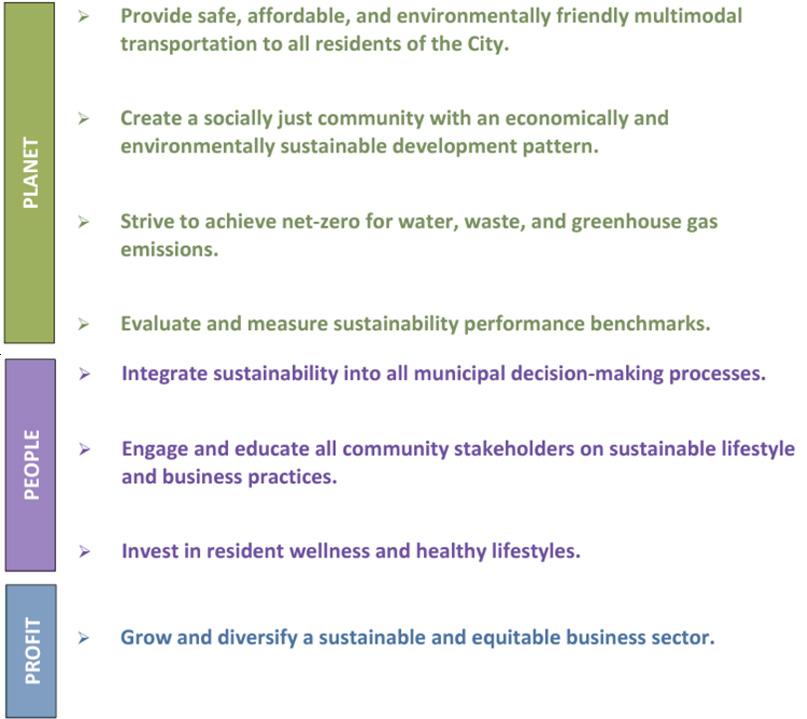
• Adopting a Sustainable Sun Prairie Report

Sun Prairie Strategic Plan
and launching a Climate Action Plan.
• Completing a Housing Study and expanding funding support for housing services through Sunshine Place, Tenant Resource Center, and Madison Department of Civil Rights.
Other Adopted Plans & Policies
In addition to the Comprehensive Plan, other adopted city policy documents require substantial changes to the city’s zoning code and development regulations to implement, including the Sustainability Report4 and the Housing for All5 study. Small area plans such as Sun Prairie Stronger and Central Main Street Redevelopment Plan utilize physical design guidelines to direct future investments in the community.
Sun Prairie Stronger Plan (2019)
The Sun Prairie Stronger Plan was adopted in 2019 to create a physical plan and vision for the area impacted by the 2017 incident that damaged or destroyed multiple downtown buildings. The plan focuses on design guidelines, frontages, and materials to guide new investment to complement the adjacent downtown historic district.
4 Sun Prairie Sustainability Report, pages 8, 14. https://cityofsunprairie.com/1189/Sustainable-Sun-Prairie
5 Sun Prairie Housing for All, pages 12, 13, 85. https:// cityofsunprairie.com/1697/Housing-for-All
Central Main Street Corridor Redevelopment Plan (2018)
This area plan guides the redevelopment of Central Main Street Corridor from Ruby Lane to Jones Street. The plan proposed three principal strategies: encourage physical, cultural and economic connectivity with surrounding areas; promote a diverse mix of commercial, residential and public uses; and target key anchor sites as redevelopment priorities. The plan relies on form-based standards to create predicable mid-rise building frontage with conditions that promote desirable walking conditions through the corridor. Some of these standards are consistent with the Main Street Overlay District, but many of the provisions are only enforceable through a Planned Development.
The Main Street Overlay District (MSO) was adopted in 2010 to implement the Main Street Corridor Plan (2006). The District creates some form-based standards and purpose statements with a streamlined approval process that creates by-right administrative approvals for proposals consistent with the adopted plan with up to one minor deviation through staff review. The MSO has been successful in terms of permitting multiple redevelopments consistent with the Main Street plans through staff review.
The Housing for All Study followed the Comprehensive Plan as a focused look at housing in the city and produced a series of recommendations. Among other data, the study illustrates that Sun Prairie had a shortfall of approximately 835 dwellings in 2019 for its lowest wealth residents, a gap anticipated to grow to 1,250 by 2040 without intervention. The report also illustrated that approximately 27% of households were cost burdened in 2019, a figure that has expected to increase significantly through conditions accelerated through the Covid-19 pandemic and associated effects. The recommended strategies for increasing supply and affordability include zoning for by right development through broadening permitted land uses, design standards, and other removing other overly restrictive regulations.
Sustainable Sun Prairie Report (2021)
In 2021, the Sustainability Task Force completed its work and produced a Report that describes multiple priorities and recommendations tied to the development pattern and characteristics of the built environment. Several other sustainability goals are determined by development pattern and zoning, including:
Active Transportation Plan (2024)
This plan reinforces the city’s vision for safety, equity, and sustainability in part by shifting mobility choices to walking, biking, and transit. Equity is prioritized through focusing investments in areas likely to most benefit priority equity areas as defined in the plan. In a holistic approach, the plan recognizes land use and urban design as strongly influencing the transportation system, and that updates to the city’s comprehensive plan and zoning ordinance are necessary to advance the goals established by this plan.
Additional Plans and Policies
The Capital Area Regional Planning Commission created a 2050 Regional Development Framework in 2022 to serve as a guide for incorporating big picture goals into individual decisions about where and how to grow. The principles of the guide are largely consistent with Sun Prairie’s adopted plans and is used as a reference for the bigger picture of policy priorities in the region.
Dane County completed a Regional Housing Strategy in 2023 that summarizes current housing related data, trends, and projections. Formulation of the Strategy resulted from many contributors, including from Sun Prairie, assembling to evaluate this data and identify consensus goals. Dane County is actively working with many partners to implement the action plan and recommendations of the Strategy. Among the finding include that Sun Prairie is expected to need 518 new dwellings each year through 2040 to keep up with regional demand .
Before analyzing specific provisions of the Zoning Code, we begin by providing general observations on the format and usability of the Code. The following are our general observations:
Subject General Observations
Overall The Code is not organized in a user or administrative-friendly manner. Following hypothetical development proposals through the code result in difficulty in locating standards and processes that are spread throughout the title, with confusing gaps and lack of pattern. The development options (conventional, loose cluster, compact cluster) creates layers of complexity with bulk regulation, use, and performance standards, with administrative procedures that vary depending upon minor differences.
Definitions The definitions include biased and may create desperate outcomes for underrepresented populations. Some definitions are outdated and others should be updated for clarity.
Districts The primary regulatory approach is to define land uses and place specific standards stemming from these activities. The physical form and performance standards are confusing and difficult to interpret.
Uses Many conventional uses require discretionary permits that create burdens and uncertainty in outcomes.
Graphics The Code includes some 2-dimensional illustrations for displaying residential development types. The images are difficult to interpret in conjunction with text and primarily illustrate building placement.
Tables The tables are lengthy and effectiveness could be improved through more effective integration with illustrations.
Discretion vs. Objective Standards
Design Standards
The Code uses descriptive guidance on how to evaluate many regulatory elements and generally lacks objective standards upon which to administrator and evaluate proposals. Discretionary reviews such as Planned Development, Rezoning, and Conditional Uses often lack clear and measurable standards for many criteria, leading to potential uncertainty and divergence in how these phrases may be interpreted, and which statements to prioritize.
The Code relies primarily on use-based and performance-based controls for regulating land use. There are some standards sprinkled in some places, but their use is inconsistent.
Legal Significant sections of the code are out-of-date with recent State and Federal laws and precedent cases, such as signs and conditional uses.
Planned Development
When property owners and investors seek to develop in a community and cannot achieve their proposals that are otherwise consistent with adopted city plans due to zoning, Planned Development is a discretionary zoning district tool that enables needed flexibility to move forward. When a high percentage of projects that are relatively conventional building types and uses in the marketplace are approved through Planned Development, this indicates that the community supports these projects but that the zoning code in inadequate, adding costs, delay, and uncertainty.
The accompanying table summarizes the number of dwellings constructed in Sun Prairie since 2016 and indicates that 85% are zoned Planned Development, including 69% of single-family homes and duplexes and over 91% of buildings with three or more units1. In
1 Many Planned Development -zoned projects were completed between 2000 – 2015. However, changes in the city’s permitting software makes aggregating these figures by zoning designation a more arduous analysis.
total, 23% of all city parcels representing 30% of the land area of the city are zoned Planned Development. These Planned Developments range from entire neighborhoods with mixed housing types, such as Smith’s Crossing and Liberty Square, commercial areas such as Prairie Lakes and Pumpkin Patch, as well as single-site greenfield and redevelopments of all types throughout the city.
Policy
There are passages throughout this code that communicate the goals and objectives guiding zoning regulations, including how discretionary standards are interpreted.
• Equity and equitable outcomes are notably absent from purpose statements and other qualitative standards of the code.
• There are several policy goals related to reducing congestion. Populated areas, especially cities, inherently have congestion due to a more concentrated population than rural areas. Where any city has a high level of accessibility and activity, which is positive, it will also have congestion. The goal of lessening congestion can be used selectively and in discriminatory ways to prevent the construction of smaller, more concentrated units that tend to be more affordable. Additionally, requirements for certain uses or zones to be located on collector or arterial streets without clear rationale or public benefit restricts uses such as multiunit housing from neighborhoods and can limit allowed locations to areas with higher health impacts. There is a notable absence of policies addressing walkability, bike lanes, and overall transportation infrastructure, which are crucial for reducing congestion and promoting sustainable urban living.

• There are multiple instances

areas represent Planned Developments (PD).
Above: Sun Prairie Zoning Map (October, 2024). The magenta
where subjective terms are used as policy goals and evaluative statements. Many of these terms can be used to create or reinforce exclusionary dynamics in the built environment. These terms should be replaced wherever possible and/or used in a secondary position to objective standards.
Organization
The organization of the Sun Prairie’s Zoning code could benefit from a more streamlined structure, where related sections are combined to enhance clarity and ease of navigation. Currently, the code is divided into multiple chapters that address various aspects of zoning, such as rules of interpretation, development standards, and specific district regulations. By consolidating sections that address similar topics, the code can be more user-friendly.
• Information is hard to find. The code lays out development standards within long passages of text, which make them challenging to find and interpret. The illustrations are difficult to interpret. Modern zoning codes present permitted uses and numeric development standards within tables with effective illustrations to make the information easy to identify and access.
• The code contains limited and outdated visuals. Graphics and illustrations should be utilized in the Code to provide a visual guide to facilitate better comprehension of concepts and standards within the Code.
• Like standards are sometimes scattered throughout the code. The Code chapters should be reorganized, and some information should be consolidated.
Standards
Development standards are the regulatory provisions within a code that govern how uses, buildings, and stie features are organized on a given property. In the initial review of development standards, we made the following observations:
• The city’s goals for housing, neighborhoods, and design, among others, are not represented in the purpose statements or the regulatory standards of the ordinance.
• The bulk, intensity, and use standards are generally incompatible with the physical design standards or objective criteria to advance adopted city plans and policies.
• The limitations that the development standards within the SR-4, MR-8, and UR12 districts are inconsistent with adopted plans and restrict housing supply. Zoning codes sometimes mandate economically inefficient land utilization, such as excessive lot standards and setbacks, which disproportionately impact lowerincome residents. This inefficiency can lead to exclusionary or segregationist effects on housing, limit investment in existing neighborhoods, and push new development to farmland and rural areas. These standards include:
› Minimum lot size, especially where additional lot size is required per residential unit on-site;
› Lot coverage maximums;
› Floor area ratio maximums;
› Height maximums;
› Excessive setbacks;
› Large buffer yard requirements;
› The limited range of housing types permitted in the SR-4, MR-8, and UR-12 districts, especially since some regulations mandate that their form and design be complementary to existing structures.
• There are dozens of different regulations for detached single family structures, with only a limited number allowed by-
right, these being large-lot with significant setbacks. There is no provision for administrative approval of minor changes. This results in most subdivisions requiring Planned Development or Conditional Uses for minor changes in standards such as reducing a setback to less than ten feet.
• Multi-unit residential building types require one or more discretionary permits and hearings in most situations.
• Far too many uses and building formats require conditional use permits. These range from some fences and small deviations in setback or bulk standards, to uses such as childcare and most multi-unit housing. Most uses should be permitted by-right through staff reviews utilizing objective standards and criteria and enable administratively imposed changes or conditions to satisfy defined goals. Discretionary reviews should be reserved for high impact uses and exceptional circumstances.
• When land uses are mixed, or do not fit neatly into a single use definition, regulations become unclear and difficult to administer. Existing standards do not accommodate these circumstances with requirements to create desirable outcomes. Examples include industrial or logistics uses with storefronts and offices, and
retail buildings with significant storage or manufacturing.
• The Main Street Overlay District (MSO) was created more recently (2010) as a tool to implement the Main Street Corridor Plan’s design-based vision and criteria with a more streamlined approval process. Although inserted into a use-based code and reliant on text descriptions, this district is an example where the city has successfully used form-based standards and administrative reviews to implement design goals.
• Most Planned Developments are used by applicants to gain relief from common bulk or performance standards that are restrictive, including: parking, setbacks, lot size, and height. This indicates that these standards are out of synch with community goals.
• Car parking requirements are known to restrict development based on inflexible ratios that impose development costs without a corresponding public purpose. Many Planned Developments in Sun Prairie have permitted lower parking ratios. Required car storage spaces should be minimized and shift focus to design standards to create desirable neighborhood design. Further reduction in minimum
spaces could be allowed administratively through implementation of transportation demand management practices, such as relationship to public transportation, providing additional bike parking, etc.
• The landscaping standards and charts are hard to comprehend and do not account for city goals including native landscaping, rain gardens, food production, and forestry. This section should be updated with regionally appropriate sustainable landscaping and site design practices.
• Use standards that use subjective terms such as “blend with”, “maintaining existing character”, and “protect the character and integrity” of neighborhoods and adjacent properties should be removed whenever possible. These terms lack objective interpretation and are used to frustrate development and selectively exclude certain uses. These terms create the illusion of incompatibility where harms or hardships are speculative or based on race, class, demographic, and lifestyle biases.
• The term “family” should not be used throughout the code and should not be defined. Instead, issues of overcrowding, health, and safety within structures should be more effectively governed by applicable governing codes. Households should have the inherent right to form regardless of whether the members are related or unrelated. It is reasonable for a municipality to implement regulations that guard against overcrowding or unsafe conditions, but mandating familial structures is an inherently flawed and discriminatory approach to achieving these objectives.
• There are many provisions allowed or recommended in adopted plans that are not found in the current ordinance, including accessory dwelling units and “dark sky” standards.
• Consider creating “bonus” overlay district(s) that enable investments consistent with adopted plans where the
city may gain additional public benefits through discretionary review, such as building height in exchange or housing affordability. This tool is most effective when it corresponds with the creation of objective design standards and permits most development through administrative review, creating the incentive for the additional development permissions and retaining focus of a Plan Commission and Council on creating effective standards and considering exceptional cases.
• Incorporating sustainability measures, such as green building practices and incentives for renewable energy use, should be applied across all districts. A recent example includes amendments for solar energy systems that contributed to the city achieving SolSmart Platinum level designation. These measures will ensure that all areas, whether residential, commercial, or industrial, contribute to the city’s environmental goals and foster a more sustainable and resilient community.
Procedures
The code organizes many activities to require discretionary approvals through rezoning or conditional use, creating intentional or unintentional barriers for these activities as well as adding cost, time, and uncertainty.
• The single administrative review (special use) permit procedure applies the same standards and fee to all project types, ranging from fences to large structures. Differentiation could be created to provide relief for more simple permits and modulate standards and fees to the complexity of the review.
• The lengthy Planned Development procedure requires six public meetings, public notices and a hearing. The ordinance text duplicates requirements for submittal with other procedures. This administrative burden is emphasized with the code’s overall reliance on this tool due
to outdated and exclusionary standards in other districts. With the creation of updated districts and standards to reduce the need for PDs, this procedure and its standards should begin fresh with a streamlined process and objective standards for the city and property owners to retain flexibility and certainty in outcomes.
• The conditional use application questions should be evaluated in light in recent legislation and best practices to ensure clarity in regulatory standards and their interpretation. The city should consider assigning review and approval of conditional uses to the Plan Commission.
Updated Legal Context
Updates in case law and state statutes have changed standards for certain procedures and uses may be regulated.
• U.S. Supreme Court cases including Reed v. Town of Gilbert (2015) and Austin v. Regan Nat. Advertising of Austin (2022) guide the legality of sign regulation by local governments, including content neutrality.
• Wisconsin 2017 Act 67 reinforced legal best practice in terms of provision of substantial evidence for evaluating conditional uses and ruling that if an applicant meets or agrees to meet all requirements and conditions in city ordinance or imposed by the zoning
board, the permit shall be issued. This statute limits how discretionary permits have been used and reinforcing the need for clear and objective standards for evaluating proposed CUPs.
• Regulations concerning certain uses, such as short-term rentals, small food producers, some home-based businesses, and establishments with liquor licenses, are among those with changes that the zoning ordinance should incorporate.
Summary Conclusion
In summary, Sun Prairie’s zoning code was created in 1989 to create a suburban development pattern and has since been updated piecemeal to address the zoning and development issues. While some more recent updates have been made to address more recent issues, the piecemeal nature of the revisions coupled with the complicated architecture of the current ordinance have resulted in a disjointed code with inconsistencies and ambiguities that creates frustration and confusion for readers, and arduous tasks for interpretation and administration.
Every provision in the new zoning code should be carefully aligned to result in conditions consistent with the community’s vision and values. A new zoning code should be simplified to improve clarity and effectiveness. Furthermore, the new code should focus on desired outcomes

relative to new construction, additions, and infill development. Critical environmental issues including climate change mitigation and resilience, especially increased incidents of extreme heat and precipitation, should be at the forefront of every decision in the new code. Every part of the code must be scrutinized to remove barriers and desperate impacts to affirmatively furthering equitable development.
Sun Prairie has adopted a Comprehensive Plan and other policies to move the community forward in pursuit of its goals. The zoning ordinance is long overdue to be updated to be consistent with implementing these objectives. The City Council has expressed a desire for a contemporary ordinance and challenged its staff to produce an effective, best-in-class zoning code.
As this report details, there is much that can be done to establish clear, consistent, userfriendly, streamlined, resilient, and defensible land use regulations that are both well founded in evidence-based best practices and custom tailored to the Sun Prairie of today and tomorrow.