ZONING CODE
City of Sidney, Ohio
Effective: February 8, 2022; Updated through April 28, 2025
This page intentionally left blank
This page intentionally left blank
SIDNEY, OHIO ZONING CODE
This page intentionally left blank
UPDATED THROUGH April 28, 2025
Section 1101.01: Title
This Zoning Code shall be known and may be cited as the “Zoning Code of the City of Sidney”, except as referred to herein, where it shall be known as “this Zoning Code”.
Section 1101.02: Purpose and Intent
This Zoning Code is enacted for the general purpose of promoting the public health, safety, comfort and welfare of the residents of the City of Sidney, and:
(a) to protect the property rights of all individuals by assuring the compatibility of uses and practices within districts;
(b) to facilitate the provision of public utilities and public services;
(c) to lessen congestion on public streets, roads and highways;
(d) to provide for the administration and enforcement of this Zoning Code, including the provision of penalties for its violation;
(e) and for any other purpose provided in this Zoning Code or the Ohio Revised Code, or under common law rulings.
Section 1101.03: Applicability
(a) In their interpretation and application, the provisions of this Zoning Code shall be the minimum requirements adopted for the promotion of the public health, safety, morals, convenience, order, prosperity and general welfare.
(b) It is not intended by this Zoning Code to repeal, abrogate, annul or in any way impair or interfere with any existing provisions of law or ordinance, or any rules, regulations or permits previously adopted or issued pursuant to law, relating to the use of buildings and land; provided, however, where this Zoning Code imposes a greater restriction on the use of buildings or premises, or on the heights of buildings, or requires larger
yards, courts or other open spaces, than are imposed or required by such existing provisions of law or ordinance, or by such rules, regulations or permits, the provisions of this Zoning Code shall prevail and control.
(c) All ordinances or parts of ordinances in conflict with this Zoning Code or inconsistent with the provisions of this Zoning Code are hereby repealed to the extent necessary to give this Zoning Code full force and effect. This Zoning Code shall become effective on the date of passage and adoption by City Council as provided by law.
(d) No building, structure or land shall hereafter be used or occupied, and no building or structure or part thereof shall hereafter be erected, constructed, reconstructed, moved or altered except in conformity with all of the regulations herein specified for the zone or district in which it is located.
(e) City-owned rights-of-way and essential services shall not be subject to the provisions of this Zoning Code.
Section 1101.04: How to Navigate This Zoning Code
(a) Step One: Locate your property and applicable district or zone on the Official Zoning Map.
(b) Step Two: Locate the applicable district or zone regulations in Chapter 1103.
(c) Step Three: Determine the use, building placement, parking, landscaping and signage regulations in the applicable district or zone in Chapters 1103, 1105, 1107, and 1109.
(d) Step Four: Determine if any nonconformities exist and how to address them in Chapter 1113.
(e) Step Five: Determine if any approvals
THROUGH April 28, 2025
are necessary and how to apply for them in Chapter 1115.
(f) Step Six: Reference the Glossary for use and general terms in Chapter 1117.
Section
1101.05:
Districts and Zones
(a) The following districts and zones are hereby established in the City and shall be designated on the Official Zoning Map by the following symbols:
Table 1: List of zones and districts.
(b) The Residential Planned Unit Development, Planned Business Center, and Planned Industrial Center districts (each a “Planned District” and, collectively, the “Planned Districts”) are no longer included in the menu of zones and districts in this Zoning Code. No new projects or developments shall use the Planned Districts. All projects previously designated as a Planned District that are not assigned a different zoning district with the adoption of this Zoning Code shall remain a Planned District and may continue to function under the
established Planned District ordinances previously adopted and specific to the development therein.
Any project within the same geographic boundaries of an existing Planned District may be redeveloped under the same provisions that were previously adopted for the Planned District.
Section 1101.06: Official Zoning Map
(a) The City is divided into zones and districts as shown on the Official Zoning Map which, together with all explanatory matter thereon, is adopted by reference and declared to be a part of this Zoning Code. A copy of the Official Zoning Map shall be maintained on file in the office of the Clerk of City Council.
(b) The new Official Zoning Map shall be identified by the signature of the Chair of the Planning Commission and attested by the Administrator under the following words: “This is to certify that this is the Official Zoning Map of the City of Sidney, Ohio, adopted on [insert adoption date], and hereby supersedes and replaces any and all previous Zoning Maps. Planning Commission Chair, Administrator.”
(c) No changes of any nature shall be made in the Official Zoning Map or matter shown thereon except in conformity with the procedures set forth in this Zoning Code. Any unauthorized change of whatever kind by any person or persons shall be considered a violation of this Zoning Code.
(d) Regardless of the existence of purported copies of the Official Zoning Map which may from time to time be made or published, the Official Zoning Map on file shall be the final authority as to the current zoning status of land and water areas, building, and other structures in the City.
Section
1101.07:
Replacement of Official Zoning Map
(a) In the event that the Official Zoning Map becomes damaged, destroyed, lost or difficult to interpret because of the nature or number of changes and additions, the Planning Commission may by resolution adopt a new Official Zoning Map which shall supersede the prior Official Zoning Map. The new Official Zoning Map may correct drafting or other errors or omissions in the prior Official Zoning Map and shall be identified by the signature of the Chair of the Planning Commission and Attested by the Administrator under the following words:
“This is to certify that this is the Official Zoning Map of the City of Sidney, adopted this [insert adoption date] and hereby supersedes and replaces any and all previous Zoning Maps.
Planning Commission Chair, Administrator.”
(b) Unless the prior Official Zoning Map has been lost or has been totally destroyed, the prior map or any significant parts thereof remaining shall be preserved, together with all available records pertaining to its adoption or amendment.
Section
1101.08:
Rules for Interpreting District Boundaries on Official Zoning Map
Where uncertainty exists as to the boundaries of districts as shown on the Official Zoning Map, the following rules shall apply.
(a) Boundaries indicated as approximately following the centerlines of streets, highways, or alleys shall be construed to follow such centerlines.
(b) Boundaries indicated as approximately following platted lot lines shall be construed as following such lot lines.
(c) Boundaries indicated as approximately following City limits shall be construed as following such City limits.
(d) Boundaries indicated as following railroad lines shall be construed to be midway between the main tracks.
(e) Boundaries indicated as following shorelines shall be construed as moving with the actual shoreline; boundaries indicated as approximately following the centerlines of streams, rivers, canals, lakes, or other bodies of water shall be construed to follow such centerlines.
(f) Boundaries indicated as parallel to, or extensions of, features listed above shall be so construed.
(g) Distances not specifically indicated on the Official Zoning Map shall be determined by the scale of the map.
Section 1101.09: Conflicts to Official Zoning Map
Where physical or cultural features existing on the ground are at variance with those shown on the Official Zoning Map, or in other circumstances not covered herein, the Administrator shall interpret the district boundaries.
Section 1101.10: Lots Divided by District Boundaries
Where a district boundary line divides a lot which was in single ownership at the time of passage of this Zoning Code, the Board of Appeals may permit, as a special exception, the extension of the regulations for either portion of the lot not to exceed 50 feet beyond the district line into the remaining portion of the lot.
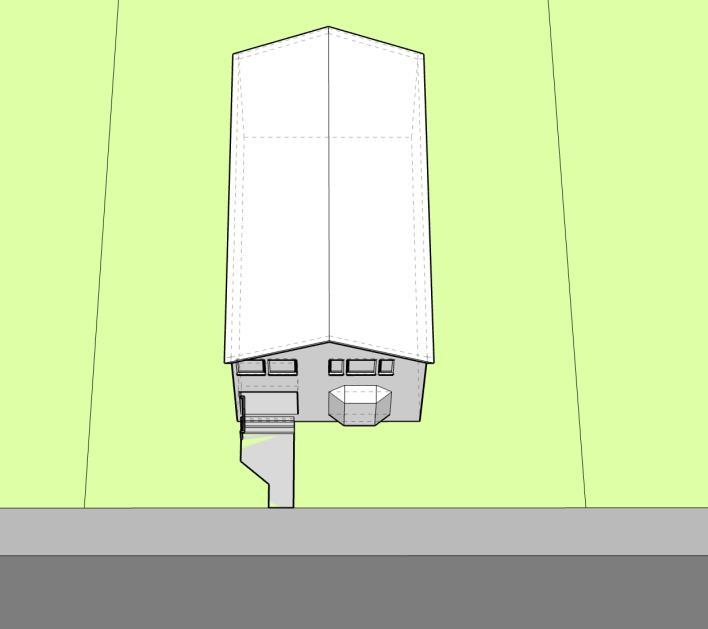
Section 1101.11: Rules of Measurement and Calculation
(a) Height Measurement
(1) In measuring heights, a habitable basement or attic shall be counted as
a story. A story in a sloping roof, the area of which story at a height of four (4) feet above the floor does not exceed two-thirds of the story immediately below it and which does not contain an independent apartment, shall be counted as a half story.
(2) Height shall be measured from the established grade in front of the lot, or from the average natural grade at the building line, if higher, to the highest point in the coping of flat roofs, or to the mid-height of a pitched or hipped roof.
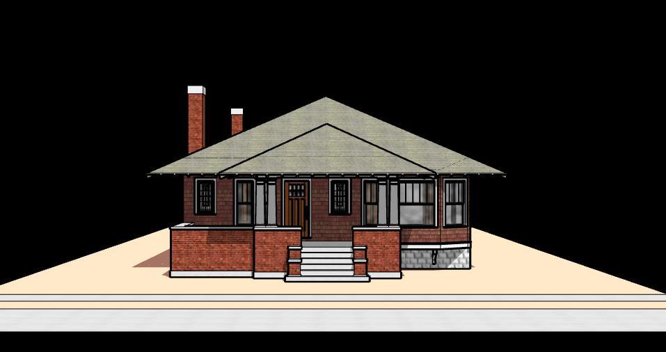
(3) Chimneys, elevators, poles, spires, tanks, towers, and other projections not used for human occupancy are not included in calculating height and may extend above the height limit.
Figure 1. Height of a dwelling, measured from the ground level to the mid-height of a pitched roof, excluding chimneys and other projections not used for human occupancy.
(b) Yards, Open Space, and Parking.
Unless otherwise permitted herein, no part of a yard, or other open space, or off-street parking or loading space required about or in connection with any building for the purpose of complying with this Zoning Code shall be included as part of a yard, open space, or off-street parking or loading space similarly required for any other building.
(c) Lot orYard Dimensions.
No yard or lot existing at the time of passage of this Zoning Code shall be reduced in dimension or area below the minimum or above the maximum requirements set forth herein. Yards or lots created after the effective date of this Zoning Code shall meet at least the minimum and shall not exceed the maximum requirements established by this Zoning Code.
Section 1101.12: Rules of Interpretation
(a) Whenever a defined word appears in the Zoning Code, its meaning is as set forth in this article. Words not defined in this Zoning Code are interpreted in accord with their usual dictionary meaning and customary usage.
(b) All references to other regulations or manuals in this Zoning Code refer to the most current version and citation for those regulations or manuals, unless expressly indicated otherwise. When the referenced regulations or documents have been repealed and not replaced by other regulations or manuals, Zoning Code requirements for compliance are no longer in effect.
(c) Illustrations, diagrams, and flowcharts are included in this Zoning Code to illustrate the intent and requirements of the text. In the case of a conflict between the text and any illustration, diagram, or flowchart, the text controls.
(d) Except as otherwise noted, any fraction greater than or equal to 0.5 will be rounded up to the nearest whole number. Any fraction less than 0.5 will be rounded down to the nearest whole number.
(e) The language of this Zoning Code shall be interpreted in accordance with the following regulations:
(1) The word “person” includes a firm, association, organization, partnership, trust, limited liability company, corporation, or other legal entity, as well as an individual.
(2) The present tense includes the future tense, the singular number includes the plural, and the plural number includes the singular, in each case, if the context so requires.
(3) The word “shall” is mandatory; the word “may” is permissive.
(4) The words “used” and “occupied” include the words “intended”, “designed”, “constructed”,“altered”, or “arranged” to be used or occupied.
(5) The word “lot” includes the words “plot”, “tract”, or “parcel”.
(6) The terms “standards”, “regulations”, and “requirements” are used to mandate a specific course of action or built outcome.
(f) Section headings are provided for ease of use and organization and shall not be interpreted as regulatory.
(g) Where a regulation involves two or more items, conditions, provisions, or events connected by the conjunction “and”,“or”, or “either ... or”, the conjunction shall be interpreted as follows:
(1) “And” indicates that all the connected items, conditions, provisions or events shall apply.
(2) “Or” indicates that the connected items, conditions, provisions or events may apply singly or in any combination.
(3) “Either ... or” indicates that all the connected items, conditions, provisions or events shall apply singly but not in combination.
Section 1101.13: Effect of Annexation on Zoning
All territory which may hereafter be annexed to the City shall be considered to be in the R-1 –Residential Single- Family Zone until or unless otherwise classified by City Council.
Section 1101.14: Private Provisions
The provisions of this Zoning Code are not intended to nullify, abolish or repeal any easement, covenant or other private agreement or restriction.
Section 1101.15: Conflicting Provisions
In the case of any conflict or inconsistency between two or more provisions of this Zoning Code or any other City ordinance, law, rule, or regulation, the provision which imposes the greater, higher, or more restrictive standard of performance shall control.
Section 1101.16: Determination of Land Uses Not Listed in this Zoning Code
Uses herein are listed as “Permitted” or “Conditional Uses.” Those uses not listed are prohibited; provided, however, it is recognized that this Zoning Code may require interpretation to assign all possible uses to individual zones and districts. Therefore, any use which is not specifically set forth in this Zoning Code shall be reviewed by the Administrator for consistency with the intent set forth in each zone or district and for compatibility with use characteristics typical of uses permitted within such zone or district. Based upon this review, the Administrator shall determine the appropriate district for any use which is not specifically set forth herein. In case of disagreement with the determination of the Administrator in assigning a use to an appropriate zone or district, any aggrieved party may file an appeal with the Zoning Board of
Appeals.
Section
1101.17:
Effect of Change of Zone or District on Existing Structures
In those instances where buildings and structures exist on a lot or parcel that is subsequently rezoned to another zone or district (zoning map amendment), those buildings and structures shall be exempt from seeking variances from the required development standards of that zone or district. All existing buildings or structures at the time of the rezoning shall be deemed to be legal nonconforming buildings or structures and shall comply with all provisions of this Zoning Code from that point forward.
Section
1101.18:
Infringement on Property Lines
(a) No proposed building, structure, facility, or sign shall infringe on or encroach upon an existing property line.
(b) A replat/vacation plat shall be required in accordance with Section 1161.05(a)(2) of the Subdivision Regulations to prevent such infringement.
Section
1101.19:
Saving Provision for Pending Enforcement Actions
Except as expressly provided for in this Zoning Code, the adoption of this Zoning Code shall not:
(a) Nullify or make void any action pending under, or by virtue of, any prior zoning code or subdivision ordinance;
(b) Discontinue, nullify, void, abate, modify or alter any penalty accruing or about to accrue under, or by virtue of, any prior zoning code or subdivision ordinance;
(c) Affect the liability of any person, firm, or corporation under, or by virtue of, any prior zoning code or subdivision ordinance;
(d) Waive any right of the City under any section or provision of any prior zoning code or subdivision ordinance; or,
(e) Vacate or annul any rights obtained by any person, firm, or corporation by lawful action of the City under, or by virtue of, any prior zoning code or subdivision ordinance.
Section 1101.20: Invalidity/Severability
Should any section or provision of this Zoning Code be declared by the courts to be unconstitutional or invalid, such decision shall not affect the validity of the Zoning Code as a whole, or any part thereof other than the part so declared to be unconstitutional or invalid.
THROUGH April 28, 2025
SIDNEY, OHIO ZONING CODE
This page intentionally left blank
UPDATED THROUGH April 28, 2025
Section 1103.01: Intent
The following districts and zones are hereby established to regulate the use of all lands within the City. The specific purpose of each district and zone shall serve as guidance for regulating existing and future development.
Section 1103.02: Compliance with Regulations
The regulations for each zone and district set forth by this Zoning Code shall be minimum regulations and shall apply uniformly to each class or kind of structure or land, except as hereinafter provided or as otherwise granted by the applicable review authority set forth herein.
(a) No building, structure or land shall be used or occupied, and no building or structure or part thereof shall be erected, constructed, reconstructed, moved or structurally altered except in conformity with all of the regulations herein specified for the district or zone in which it is located.
(b) No building or other structure shall be erected or altered to provide for greater height or bulk, to accommodate or house a greater number of dwelling units or households, to occupy a greater percentage of lot area, or to have narrower or smaller yards or other open spaces than herein required, or in any other manner be contrary to the provisions of this Zoning Code.
(c) No yard or lot existing at the time of passage of this Zoning Code shall be reduced in dimension or area below the minimum or above the maximum requirements set forth herein. Yards or lots created after the effective date of this Zoning Code shall meet at least the minimum requirements and shall not exceed the maximum requirements set forth herein.
(d) Notwithstanding anything to the
contrary contained herein, any single lot of record existing before the effective date of this Zoning Code shall comply with the yard dimension requirements in effect at the time such lot was platted and/or created.
Section 1103.03: District Regulations
(b) Supplemental regulations applicable to landscaping, signage, and parking and loading are found in Chapters 1105, 1107, and 1109, respectively.
(c) Generally applicable regulations relative to certain uses are found in Chapter 1111.
Section 1103.04: Chapter Order and List of Districts and Zones
(a) Residential Zones
(1) R-1 Residential Single-Family
(2) R-2 Residential Two-Family
(3) R-3 Residential Multi-Family
(b) Commercial Zones
(1) HC Highway Commerce
(2) CC Corridor Commerce
(3) NC Neighborhood Commerce
(4) IIM Industry/Innovation/Manufacturing
(c) Districts
(1) CSD Court Square
(2) TND Traditional Neighborhood
Section 1103.05: Diagram of Standards
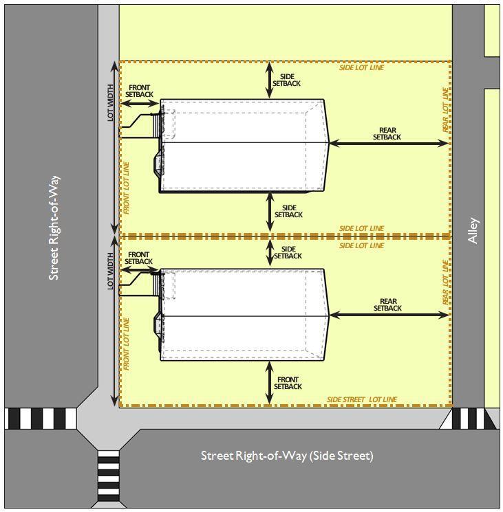
The following diagram illustrates the building placement terms used throughout this chapter. The diagram is for informative purposes and is not regulatory.
Figure 2. Diagram of Standards. Building placement and dimensional terms are illustrated for an interior lot (upper) and a corner lot (lower).
Section 1103.06: Classification of
Permitted Uses
Permitted uses are listed in the use table on the following pages. The following symbols are used in the table and are defined as follows:
(a) Principally Permitted Use (P)
“P” indicates that a use is permitted in the zone or district as a principal use. The use is also subject to all other applicable requirements of this Zoning Code.
(b) Conditional Use (C)
“C” indicates that a use may be permitted in the zone or district only where approved in accordance with the conditional use standards set forth herein and conditional use approval granted by the Board of Appeals as outlined in Chapter 1115. Conditional uses are subject to all other applicable requirements of this Zoning Code.
(c) Permitted Accessory Use (PA)
“PA” indicates a use may be permitted as an accessory use to a principal use. Permitted accessory uses are subject to all other applicable requirements of this Zoning Code.
(d) Use Not Permitted
A blank cell indicates that a use is not permitted in the zone or district. Uses not listed as a Principally Permitted Use, Permitted Accessory Use, or Conditional Use, are prohibited from the applicable zone or district.
(e) Use Not Listed
It is not possible for a list of permitted
uses to capture every possible use that could be established. The City will occasionally receive an application for approval of a use that is not expressly listed in the use table. In those instances:
(1) The Administrator will determine if a proposed use is similar to a listed use based on the following factors:
A. Whether the proposed use is consistent with the Comprehensive Plan, Master Plan, or Area Plan and the purpose and intent of the zone or district.
B. Whether the use has similar impacts on the neighborhood, such as traffic, noise, lighting, or similar considerations.
C. Whether the use has the same characteristics as a listed use in terms of building and site arrangement, site area or floor space, equipment devoted to the activity, customer type, number of employees in each activity, hours of operation, vehicles used and parking requirements, number of vehicle trips generated, signs, and how the use is advertised.
(2) If it is determined that a proposed use is similar to a listed use, the regulations governing that use apply to the unlisted use.
(3) If it is determined that a proposed use is not similar to a listed use, then the proposed use shall be deemed to be prohibited. The decision of the Administrator is appealable to the Board of Appeals under Chapter 1115.
Section 1103.07: Permitted Uses
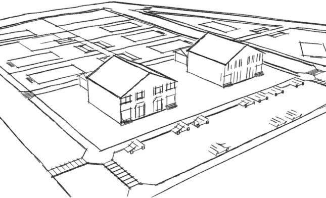
Section 1103.08: R-1 - Residential Single-Family Zone
Building Placement
Lot Dimensions
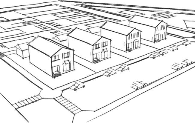
Figure 3. An illustration of the potential development pattern in the R-1 Zone.
(a) Intent
The Residential Single-Family (R-1) Zone is intended to maintain and promote existing and provide for new suburban-style, single-family neighborhood development patterns in numerous areas throughout the City. The desired development pattern in the R-1 Zone follows a suburban-style development pattern of single-family residential structures situated on front yards.
(b) Uses
The uses permitted or conditionally permitted, including accessory uses, in the R-1 zone are set forth on the Use Table in Section 1103.06.
(c) Development Standards
The standards applicable to the development of property within the R-1 Zone are set forth in the following tables and illustrated in the following diagrams. Building placement, form, and component standards are as follows:
Building Form & Components
Height Building
Accessory
ADU Height (max.) Not Permitted Height, non-ADU (max.) 18 ft
Parking Location
No parking except on gravel, asphalt, concrete, pavers or similar surface in front or side yards
Signs
1 monument per subdivision entrance
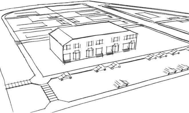
Section 1103.09: R-2 - Residential Two-Family Zone
Figure 4. An illustration of the potential development pattern in the R-2 Zone.
(a) Intent
The Residential Two-Family (R-2) Zone is intended to maintain and promote existing and provide for new suburban-style duplex neighborhood development patterns in numerous areas throughout the City. The desired development pattern in the R-2 Zone follows a suburbanstyle development pattern of two-family duplex residential structures situated on front yards.
(b) Uses
The uses permitted or conditionally permitted, including accessory uses, in the R-2 zone are set forth on the Use Table in Section 1103.06.
(c) Development Standards
The standards applicable to the development of property within the R-2 Zone are set forth in the following tables and illustrated in the following diagrams. Building placement, form, and component standards are as follows:
Building Placement
Lot Dimensions
Lot Size (min.) 6,000 SF (singlefamily); 8,000 SF (two-family)
Lot Width (min.) 50 ft (singlefamily); 60 ft (twofamily)
Multi-Family Residential Density
Units Per Acre (max.) 4 Units
Setbacks
Front Yard (min.) 25 ft
Side Yard (min., each side) 8 ft to adjacent side lot line; none between attached units
Rear Yard (min.) 25 ft Use Area Unit Area (min.)
Building Form & Components
Height
Building Height (max.) 35 ft
Accessory Building
Building Location
Rear yard only; 5 ft min. from any lot line; 10 ft min. from rear wall of primary structure
ADU Height (max.) Not Permitted
Height, non-ADU (max.) 18 ft
Parking Location
No parking except on gravel, asphalt, concrete, pavers or similar surface in front or side yards
Signs
1 monument per subdivision entrance
Section 1103.10: R-3 - Residential Multi-Family Zone
Figure 5. An illustration of the potential development pattern in the R-3 Zone.
(a) Intent
The Residential Multi-Family (R-3) Zone is intended to maintain and promote existing and provide for new multi-family residential development patterns in appropriate areas throughout the City. The desired development pattern in the R-3 Zone promotes stacked flats buildings either in stand- alone urban environments or in suburban-style complexes.
(b) Uses
The uses permitted or conditionally permitted, including accessory uses, in the R-3 zone are set forth on the Use Table in Section 1103.06.
(c) Development Standards
The standards applicable to the development of property within the R-3 Zone are set forth in the following tables and illustrated in the following diagrams. Building placement, form, and component standards are as follows: Building Placement
Parking Location
Rear or side yard, well-screened; private garages; structured parking Signs
1 monument per entrance to development
(d) Density Bonus
(1) The purpose of the green infrastructure incentive is to recognize and incentivize design criteria that benefit the community by reducing environmental impacts and stressors on the city’s infrastructure. Density bonuses are based upon a point system.
(2) Bonus incentives may be used only on the property on which the points have been earned. In order to be eligible for bonus incentives, documentation must be included in the site plan submittal detailing each design criteria for which bonus incentives are requested.
(3) Increased density per acre is permitted as follows:
(4) For the purposes of applying the density bonus of this section the following definitions shall apply:
A. Native Vegetation. A minimum of fifty percent of the planted area shall be native and appropriate for site conditions, including but not limited to levels of moisture, shade, slope, wind, types of local wildlife, and proximity to existing or future dwellings. Plantings shall include a mix of trees or shrubs and living ground cover. Native plantings shall be identified by genius and species on landscaping plans.
B. Permeable Materials. A minimum of fifty percent of proposed impervious surfaces, excepting vehicular use areas. Permeable surfaces for this purpose include, but are not limited to, patios, walkways, sport courts, and sidewalk areas. Permeable materials may be used on all soil types where information has been generated by a certified professional demonstrating that the pervious material will function as designed.
Density Bonus
At least 1, but no more than 2 points
At least 3, but no more than 5 points
At least 6 points
Up to 6% density increase; maximum of 19 dwelling units per acre
Up to 12% density increase; maximum of 20 dwelling units per acre
Up to 18% density increase; maximum of 21 dwelling units per acre
Maximum Density may be increased as per Section 1103.10(d).
Section 1103.11: HC - Highway Commerce Zone
6. An illustration of the potential development pattern in the HC Zone.
(a) Intent
The Highway Commerce (HC) Zone is intended to maintain and promote existing commercial and provide for new large-scale commercial development patterns primarily along and oriented toward major arterial corridors and interstate interchanges. The desired development pattern in the HC Zone follows an automobile-oriented development pattern of medium-to-large-scale commercial buildings.
(b) Uses
The uses permitted or conditionally permitted, including accessory uses, in the HC Zone are set forth on the Use Table in Section 1103.06.
(c) Development Standards
The standards applicable to the development of property within the HC Zone are set forth in the following tables and illustrated in the following diagrams. Building placement, form, and component standards are as follows:
Building Placement Setbacks Front
Rear yard only; 5 ft min. from any lot line; 10 ft min. from rear wall of primary structure
Height (max.) Not Permitted
(max.)
Parking Location
N/A
Signs
One detached sign per street frontage; attached signs shall not exceed the aggregate three square feet of area for each linear foot of building frontage for each business use
Figure
Section 1103.12: CC - Corridor Commerce Zone
7. An illustration of the potential development pattern in the CC Zone.
(d) Intent
The Corridor Commerce (CC) Zone is intended to maintain and promote existing commercial and provide for new medium-scale commercial development patterns primarily along and oriented toward minorand major arterials The desired development pattern in the CC Zone follows a multimodal-oriented development pattern of medium-to-large-scale commercial buildings.
(e) Uses
The uses permitted or conditionally permitted, including accessory uses, in the CC Zone are set forth on the Use Table in Section 1103.06.
(f) Development Standards
The standards applicable to the development of property within the CC Zone are set forth in the following tables and illustrated in the following diagrams. Building placement, form, and component standards are as follows:
Building Placement Setbacks
Coverage/Open Space
Building Form & Components
Building Location
Rear yard only; 5 ft min. from any lot line; 10 ft min. from rear wall of primary structure ADU Height (max.) Not Permitted
(max.)
Parking Location
Rear or side; front only permitted if less than 1/3of total parking area
Signs
One detached sign per street frontage; attached signs shall not exceed the aggregate three square feet of area for each linear foot of building frontage for each business use
Figure
Section 1103.13: NC - Neighborhood Commerce Zone
Figure 8 An illustration of the potential development pattern in the NC Zone.
(a) Intent
The Neighborhood Commerce (NC) Zone is intended to maintain and promote existing and provide for new small-to-medium-scale commercial development patterns primarily along and oriented toward the intersections of minor and major arterials. The desired development pattern in the NC Zone follows a pedestrian-oriented development pattern of smallto-medium-scale commercial buildings that primarily serve neighboring and nearby residents.
(b) Uses
The uses permitted or conditionally permitted, including accessory uses, in the NC Zone are set forth on the Use Table in Section 1103.06.
(c) Development Standards
The standards applicable to the development of property within the NC Zone are set forth in the following tables and illustrated in the following diagrams. Building placement, form, and component standards are as follows:
Signs
One detached sign per street frontage; attached signs shall not exceed the aggregate three square feet of area for each linear foot of building frontage for each business use
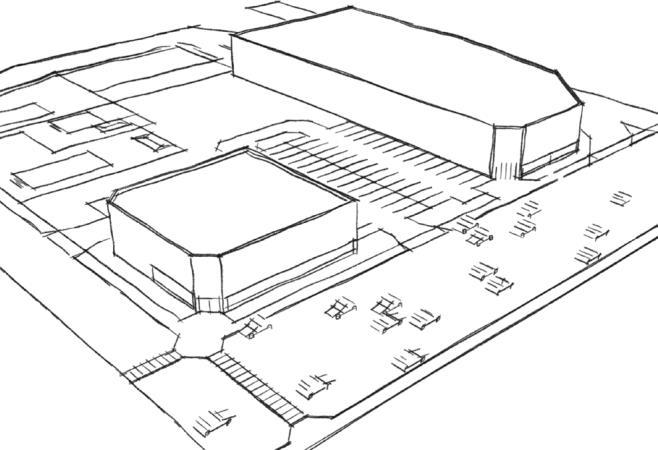
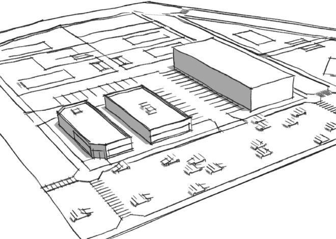
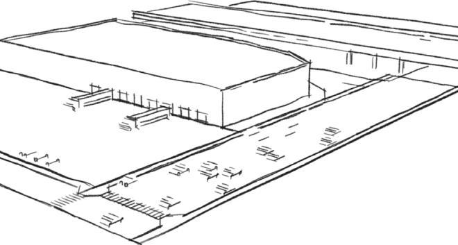
Section 1103.14: IIM - Industry/Innovation/Manufacturing Zone
Figure 9 An illustration of the potential development pattern in the IIM Zone.
(a) Intent
The Industry/Innovation/Manufacturing (IIM) Zone is intended to maintain and promote existing and provide for new medium-to-large-scale facilities that promote employment growth and establishment in the City. The IIM development patterns are primarily located along and oriented toward major arterial corridors and interstate interchanges. The desired development pattern in the IIM Zone follows an automobile-oriented development pattern of medium-to-large-scale manufacturing, warehouse and distribution buildings.
(b) Uses
The uses permitted or conditionally permitted, including accessory uses, in the IIM Zone are set forth on the Use Table in Section 1103.06.
(c) Development Standards
The standards applicable to the development of property within the IIM Zone are set forth in the following tables and illustrated in the following diagrams. Building placement, form, and component standards are as follows:
Building
Form & Components
Location
on distance from centerline of adjacent
yard only; 5 ft min. from any lot line; 10 ft min. from rear wall of primary structure
Height (max.) Not Permitted
One detached sign per street frontage; attached signs shall not exceed the aggregate three square feet of area for each linear foot of building frontage for each business use
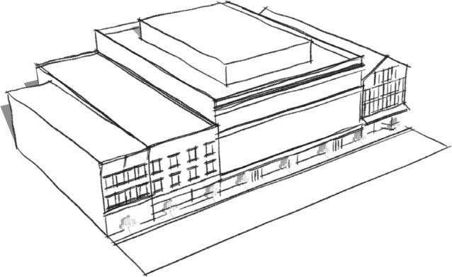
Section 1103.15: CSD - Court
Square District
Figure 10 An illustration of the potential development pattern in the CSD.
(a) Intent
The Court Square District (CSD) is intended to designate the area surrounding the historic Court Square in order to maintain and promote the existing historic mixed-use urban development patterns of downtown Sidney. The desired development pattern in the CSD follows the historic development pattern of downtown Sidney.
(b) Uses
The uses permitted or conditionally permitted, including accessory uses, in the CSD are set forth on the Use Table in Section 1103.06.
(c) Development Standards
The standards applicable to the development of property within the CSD are set forth in the following tables and illustrated in the following diagrams. Building placement, form, and component standards are as follows:
Building Placement Setbacks
Building Location Not Permitted Parking Location Rear yard or side yard accessible by alley only
Any two: Wall, Projecting, Hanging; Window
Design Standards
Natural materials on all facades
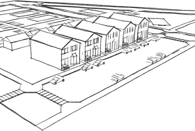
Section 1103.16: TND - Traditional
Neighborhood District
Figure 11. An illustration of the potential development pattern in the TND.
(a) Intent
The Traditional Neighborhood District (TND) is intended to maintain and promote the existing traditional neighborhood development patterns surrounding downtown Sidney. The desired development pattern in the TND follows the traditional development pattern of single-family, two-family, and three-family residential structures oriented along streets with sidewalks and in some instances alley-loaded garages. The scale, form, and building types reflect a walkable development pattern primarily of the 19101930’s.
(b) Uses
The uses permitted or conditionally permitted, including accessory uses, in the TND are set forth on the Use Table in Section 1103.06.
(c) Development Standards
The standards applicable to the development of property within the TND are set forth in the following tables and illustrated in the following diagrams. Building placement, form, and component standards are as follows:
Building Placement
Lot
Building
Parking
No parking except on gravel, asphalt, concrete, pavers or similar surface in front or side yards
Signs
1 monument per subdivision entrance
Section 1103.17: Flood Hazard Areas:
(a) Purpose and Intent
(1) The City of Sidney has special flood hazard areas that are subject to periodic inundation which may result in loss of life and property, health and safety hazards, disruption of commerce and governmental services, extraordinary public expenditures for flood protection and relief, and impairment of the tax base. Additionally, structures that are inadequately elevated, floodproofed, or otherwise protected from flood damage also contribute to the flood loss. In order to minimize the threat of such damages and to achieve the purposes hereinafter set forth, these regulations are adopted.
(2) It is the purpose of these regulations to promote the public health, safety and general welfare, and to:
A. Protect human life and health;
B. Minimize expenditure of public money for costly flood control projects;
C. Minimize the need for rescue and relief efforts associated with flooding and generally undertaken at the expense of the general public;
D. Minimize prolonged business interruptions;
E. Minimize damage to public facilities and utilities such as water and gas mains, electric, telephone and sewer lines, streets and bridges located in areas of special flood hazard;
F. Help maintain a stable tax base by providing for the proper use and development of areas of special flood hazard so as to protect property and minimize future flood blight areas;
G. Ensure that those who occupy the areas of special flood hazard assume responsibility for their actions;
H. Minimize the impact of development on adjacent properties within and near flood prone areas;
I. Ensure that the flood storage and conveyance functions of the floodplain are maintained;
J. Minimize the impact of development on the natural, beneficial values of the floodplain;
K. Prevent floodplain uses that are either hazardous or environmentally incompatible; and
L. Meet community participation requirements of the National Flood Insurance Program.
(3) In order to accomplish its purposes, these regulations include methods and provisions for:
A. Restricting or prohibiting uses which are dangerous to health, safety, and property due to water hazards, or which result in damaging increases in flood heights or velocities;
B. Requiring that uses vulnerable to floods, including facilities which serve such uses, be protected against flood damage at the time of initial construction;
C. Controlling the alteration of natural floodplains, stream channels, and natural protective barriers, which help accommodate or channel flood waters;
D. Controlling filling, grading, dredging, excavating, and other development which may increase flood damage; and, E. Preventing or regulating the construction of flood barriers which
will unnaturally divert flood waters, or which may increase flood hazards in other areas.
(4) These regulations shall apply to all areas of special flood hazard within the jurisdiction of the City as identified herein, including any additional areas of special flood hazard annexed by the City.
(5) For the purposes of these regulations, the following studies and/or maps are adopted:
A. The areas of special flood hazard have been identified by the Federal Emergency Management Agency in a scientific and engineering report entitled, “Flood Insurance Study, Shelby County Ohio”, effective April 2, 2015. This study, with accompanying Flood Insurance Rate Maps date April 2, 2015, and any revisions thereto, is hereby adopted by reference and declared to be a part of this chapter. The Flood Insurance Study and accompanying maps are available in the office of the Community Development Department.
(6) Any revisions to the aforementioned maps and/ or studies are hereby adopted by reference and declared to be a part of these regulations. Such maps and/or studies are on file at the Office of the City Manager, City Hall, 201 W. Poplar Street, Sidney, Ohio.
(7) These regulations are not intended to repeal any existing ordinances (resolutions) including subdivision regulations, zoning or building codes. In the event of a conflict between these regulations and any other ordinance (resolution), the more restrictive shall be followed. These regulations shall not impair any deed restriction covenant or easement but the land subject to such
interests shall also be governed by the regulations.
(8) In the interpretation and application of these regulations, all provisions shall be:
A. Considered as minimum requirements;
B. Liberally construed in favor of the governing body; and,
C. Deemed neither to limit nor repeal any other powers granted under state statutes. Where a provision of these regulations may be in conflict with a state or Federal law, such state or Federal law shall take precedence over these regulations.
(9) The degree of flood protection required by these regulations is considered reasonable for regulatory purposes and is based on scientific and engineering considerations. Larger floods can and will occur on rare occasions. Flood heights may be increased by man-made or natural causes. These regulations do not imply that land outside the areas of special flood hazard or uses permitted within such areas will be free from flooding or flood damage. These regulations shall not create liability on the part of the City, any officer or employee thereof, or the Federal Emergency Management Agency, for any flood damage that results from reliance on these regulations or any administrative decision lawfully made thereunder.
(10)Should any section or provision of these regulations be declared by the courts to be unconstitutional or invalid, such decision shall not affect the validity of the regulations as a whole, or any part
thereof other than the part so declared to be unconstitutional or invalid.
(b) Flood District Administration
(1) The Administrator is hereby appointed to administer and implement these regulations and is referred to herein as the Floodplain Administrator.
(2) The duties and responsibilities of the Floodplain Administrator shall include but are not limited to:
A. Evaluate applications for permits to develop in special flood hazard areas;
B. Interpret floodplain boundaries and provide flood hazard and flood protection elevation information;
C. Issue permits to develop in special flood hazard areas when the provisions of these regulations have been met or refuse to issue the same in the event of noncompliance;
D. Inspect buildings and lands to determine whether any violations of these regulations have been committed;
E. Make and permanently keep all records for public inspection necessary for the administration of these regulations including Flood Insurance Rate Maps, Letters of Map Amendment and Revision, records of issuance and denial of permits to develop in special flood hazard areas, determinations of whether development is in or out of special flood hazard areas for the purpose of issuing floodplain development permits, elevation certificates, variances, and records of enforcement actions taken for
violations of these regulations;
F. Enforce the provisions of these regulations;
G. Provide information, testimony, or other evidence as needed during variance hearings;
H. Coordinate map maintenance activities and FEMA follow-up; and
I. Conduct substantial damage determinations to determine whether existing structures, damaged from any source and in special flood hazard areas identified by FEMA, must meet the development standards of these regulations.
(3) It shall be unlawful for any person to begin construction or other development activity including but not limited to filling; grading; construction; alteration, remodeling, or expanding any structure; or alteration of any watercourse wholly within, partially within or in contact with any identified special flood hazard area until a floodplain development permit is obtained from the Floodplain Administrator. Such floodplain development permit shall show that the proposed development activity is in conformity with the provisions of these regulations. No such permit shall be issued by the Floodplain Administrator until the requirements of these regulations have been met.
(4) An application for a floodplain development permit shall be required for all development activities located wholly within, partially within, or in contact with an identified special flood hazard area. Such application shall be made by the owner of the property or his/ her authorized agent, herein referred to as the applicant, prior to
the actual commencement of such construction on a form furnished for that purpose. Where it is unclear whether a development site is in a special flood hazard area, the Floodplain Administrator may require an application for a floodplain development permit to determine the development’s location. Such applications shall include, but not be limited to:
A. Site plans drawn to scale showing the nature, location, dimensions, and topography of the area in question, the location of existing or proposed structures, fill, storage of materials, drainage facilities, and the location of the foregoing;
B. Elevation of the existing, natural ground where structures are proposed;
C. Elevation of the lowest floor, including basement, of all proposed structures;
D. Such other material and information as may be requested by the Floodplain Administrator to determine conformance with and provide enforcement of these regulations; and
E. Technical analyses conducted by the appropriate design professional registered in the State of Ohio and submitted with an application for a floodplain development permit when applicable:
1. Floodproofing certification for non- residential floodproofed structure as required herein;
2. Certification that fully enclosed areas below the lowest floor of a structure not meeting the design requirements herein are designed to automatically equalize hydrostatic flood forces;
3. Description of any watercourse alteration or relocation that the flood carrying capacity of the watercourse will not be diminished, and maintenance assurances as required herein;
4. A hydrologic and hydraulic analysis demonstrating that the cumulative effect of proposed development, when combined with all other existing and anticipated development will not increase the water surface elevation of the base flood by more than one foot in special flood hazard areas where the Federal Emergency Management Agency has provided base flood elevations but no floodway as required herein;
5. A hydrologic and hydraulic engineering analysis showing impact of any development on flood heights in an identified floodway as required herein; and
6. Generation of base flood elevation(s) for subdivision and large-scale developments as required herein.
(c) Review and Approval of a Floodplain Development Permit Application
(1) After receipt of a complete application, the Floodplain Administrator shall review the application to ensure that the standards of these regulations have been met. No floodplain development permit application shall be reviewed until all
information required herein has been received by the Floodplain Administrator.
(2) The Floodplain Administrator shall review all floodplain development permit applications to assure that all necessary permits have been received from those federal, state, or local governmental agencies from which prior approval is required. The applicant shall be responsible for obtaining such permits as required including permits issued by the U.S. Army Corps of Engineers under Section 10 of the Rivers and Harbors Act and Section 404 of the Clean Water Act, and the Ohio Environmental Protection Agency under Section 401 of the Clean Water Act.
(3) Within 30 days after the receipt of a complete application, the Floodplain Administrator shall either approve or disapprove the application. If an application is approved, a floodplain development permit shall be issued. All floodplain development permits shall be conditional upon the commencement of work within one year. A floodplain development permit shall expire one year after issuance unless the permitted activity has been substantially begun and is thereafter pursued to completion.
(4) The Floodplain Administrator shall make periodic inspections at appropriate times throughout the period of construction in order to monitor compliance with permit conditions.
(5) The following as-built certifications are
required after a floodplain development permit has been issued:
A. For new or substantially improved residential structures, or nonresidential structures that have been elevated, the applicant shall have a Federal Emergency Management Agency Elevation Certificate completed by a registered surveyor to record as-built elevation data. For elevated structures in Zone A and Zone AO areas without a base flood elevation, the elevation certificate may be completed by the property owner or owner’s representative.
B. For all development activities subject to the standards herein, a Letter of Map Revision.
(6) A floodplain development permit shall be revocable, if among other things, the actual development activity does not conform to the terms of the application and permit granted thereon. In the event of the revocation of a permit, an appeal may be taken to the Appeals Board in accordance with these regulations.
(7) An application for a floodplain development permit shall not be required for:
A. Maintenance work such as roofing, painting, and basement sealing, or for small nonstructural development activities (except for filling and grading) valued at less than $5,000;
B. Development activities in an existing or proposed manufactured home park
that are under the authority of the Ohio Department of Health and subject to the flood damage reduction provisions of the Ohio Administrative Code Section 3701;
C. Major utility facilities permitted by the Ohio Power Siting Board under R.C. Chapter 4906;
D. Hazardous waste disposal facilities permitted by the Hazardous Waste Siting Board under R.C. Chapter 3734; or
E. Development activities undertaken by a federal agency and which are subject to Federal Executive Order 11988 – Floodplain Management.
(8) Any proposed action exempt from filing for a floodplain development permit is also exempt from the standards of these regulations.
(9) To meet National Flood Insurance Program minimum requirements to have flood data reviewed and approved by FEMA, and to ensure that Sidney flood maps, studies, and other data identified herein accurately represent flooding conditions so appropriate floodplain management criteria are based on current data, the following map maintenance activities are identified:
A. For all development proposals that impact floodway delineations or base flood elevations, the community shall ensure that technical data reflecting such changes be submitted to FEMA within six months of the date such information becomes available.
These development proposals include:
1. Floodway encroachments that increase or decrease base flood elevations or alter floodway boundaries;
2. Fill sites to be used for the placement of proposed structures where the applicant desires to remove the site from the special flood hazard area;
3. Alteration of watercourses that result in a relocation or elimination of the special flood hazard area, including the placement of culverts; and
4. Subdivision or large-scale development proposals requiring the establishment of base flood elevations as set forth herein.
B. It is the responsibility of the applicant to have technical data, as required herein, prepared in a format required for a Conditional Letter of Map Revision or Letter of Map Revision, and submitted to FEMA. Submittal and processing fees for these map revisions shall be the responsibility of the applicant.
C. The Floodplain Administrator shall require a Conditional Letter of Map Revision prior to the issuance of a floodplain development permit for:
1. Proposed floodway encroachments that increase the base flood elevation; and
2. Proposed development which increases the base flood elevation by more than
one foot in areas where FEMA has provided base flood elevations but no floodway.
D. Floodplain development permits issued by the Floodplain Administrator shall be conditioned upon the applicant obtaining a Letter of Map Revision from FEMA for any development proposal subject to these regulations.
(10)The Floodplain Administrator may request changes to any of the information shown on an effective map that does not impact floodplain or floodway delineations or base flood elevations, such as labeling or planimetric details. Such a submission shall include appropriate supporting documentation made in writing by the City Manager of City of Sidney and may be submitted at any time.
(11)Upon occurrence, the Floodplain Administrator shall notify FEMA in writing whenever the boundaries of the City of Sidney have been modified by annexation or the community has assumed authority over an area, or no longer has authority to adopt and enforce floodplain management regulations for a particular area. In order that the City of Sidney Flood Insurance Rate Map accurately represent the City of Sidney boundaries, the notice shall include a copy of a map of the City of Sidney suitable for reproduction, clearly showing the new corporate limits or the new area for which the City of Sidney has assumed or relinquished floodplain management regulatory authority.
(d) Flood Hazard Guidelines
(1) The following guidelines shall apply to the use and interpretation of maps and other data showing areas of special flood hazard:
A. In areas where FEMA has not identified special flood hazard areas, or in FEMA identified special flood hazard areas where base flood elevation and floodway data have not been identified, the Floodplain Administrator shall review and reasonably utilize any other flood hazard data available from a federal, state, or other source.
B. Base flood elevations and floodway boundaries produced on FEMA flood maps and studies shall take precedence over base flood elevations and floodway boundaries by any other source that reflect a reduced floodway width and/or lower base flood elevation. Other sources of data, showing increased base flood elevations and/or larger floodway areas than are shown on FEMA flood maps and studies, shall be reasonably used by the Floodplain Administrator.
C. The Floodplain Administrator shall make interpretations, where needed, as to the exact location of the flood boundaries and areas of special flood hazard. A person contesting the determination of the location of the boundary shall be given a reasonable opportunity to appeal the interpretation as provided herein.
D. Where a map boundary showing an area of special flood hazard and field elevations disagree, the base flood elevations or flood protection elevations (as found on an elevation profile, floodway data table, established high water marks, etc.) shall prevail.
(e) Flood Damage
(1) Damages to structures may result from a variety of causes including flood, tornado, wind, heavy snow, fire, etc. After such a damage event, the Floodplain Administrator shall:
A. Determine whether damaged structures are located in special flood hazard areas;
B. Conduct substantial damage determinations for damaged structures located in special flood hazard areas; and
C. Make reasonable attempt to notify owners of substantially damaged structures of the need to obtain a floodplain development permit prior to repair, rehabilitation, or reconstruction.
(2) Additionally, the Floodplain Administrator may implement other measures to assist with the substantial damage determination and subsequent repair process. These measures include issuing press releases, public service announcements, and other public information materials related to the floodplain development permits and repair of damaged structures; coordinating with other federal, state, and local agencies to assist with substantial damage determinations; providing owners of damaged structures materials and other information related to the proper repair of damaged structures in special flood hazard areas; and assist owners of substantially damaged structures with Increased Cost of Compliance insurance claims.
(f) Use and Development Standards for Flood Hazard Reduction
The following use and development standards apply to development wholly within, partially within, or in contact with any special flood hazard area as established herein:
(1) Permitted Uses.
All uses not otherwise prohibited in this section or any other applicable land use regulation adopted by City are allowed provided they meet the provisions of these regulations.
(2) Prohibited
Uses
A. Private water supply systems in all special flood hazard areas identified by FEMA, permitted under R.C. Chapter 3701.
B. Infectious waste treatment facilities in all special flood hazard areas, permitted under R.C. Chapter 3734.
(3) The following standards apply to all water supply, sanitary sewerage and waste disposal systems not otherwise regulated by the Ohio Revised Code:
A. All new and replacement water supply systems shall be designed to minimize or eliminate infiltration of flood waters into the systems;
B. New and replacement sanitary sewerage systems shall be designed to minimize or eliminate infiltration of flood waters into the systems and discharge from the systems into flood waters; and,
C. On-site waste disposal systems shall be located to avoid impairment to or contamination from them during flooding.
(4) Subdivisions and Large Developments
A. All subdivision proposals shall be consistent with the need to minimize flood damage and are subject to all applicable standards in these regulations.
B. All subdivision proposals shall have
public utilities and facilities such as sewer, gas, electrical, and water systems located and constructed to minimize flood damage.
C. All subdivision proposals shall have adequate drainage provided to reduce exposure to flood damage; and
D. In all areas of special flood hazard where base flood elevation data are not available, the applicant shall provide a hydrologic and hydraulic engineering analysis that generates base flood elevations for all subdivision proposals and other proposed developments containing at least 50 lots or 5 acres, whichever is less.
E. The applicant shall meet the requirement to submit technical data to FEMA herein when a hydrologic and hydraulic analysis is completed that generates base flood elevations as required herein.
(5) Residential Structures
A. New construction and substantial improvements shall be anchored to prevent flotation, collapse, or lateral movement of the structure resulting from hydrodynamic and hydrostatic loads, including the effects of buoyancy. Where a structure, including its foundation members, is elevated on fill to or above the base flood elevation, the requirements for anchoring herein, and construction materials resistant to flood damage herein are satisfied.
B. New construction and substantial improvements shall be constructed with methods and materials resistant to flood damage.
C. New construction and substantial improvements shall be constructed with electrical,
heating, ventilation, plumbing and air conditioning equipment and other service facilities that are designed and/or elevated so as to prevent water from entering or accumulating within the components during conditions of flooding.
D. New construction and substantial improvement of any residential structure, including manufactured homes, shall have the lowest floor, including basement, elevated to or above the flood protection elevation. In Zone AO areas with no elevations specified, the structure shall have the lowest floor, including basement, elevated at least two feet above the highest adjacent natural grade.
(6) New construction and substantial improvements, including manufactured homes, that do not have basements and that are elevated to the flood protection elevation using pilings, columns, posts, or solid foundation perimeter walls with openings sufficient to allow unimpeded movement of flood waters may have an enclosure below the lowest floor provided the enclosure meets the following standards:
A. Be used only for the parking of vehicles, building access, or storage; and
B. Be designed and certified by a registered professional engineer or architect to automatically equalize hydrostatic flood forces on exterior walls by allowing for the entry and exit of floodwaters; or
C. Have a minimum of two openings on different walls having a total net area not less than one square inch for every square foot of enclosed area, and the bottom of all such openings being no higher
than one-foot above grade. The openings may be equipped with screens, louvers, or other coverings or devices provided that they permit the automatic entry and exit of floodwaters.
D. Manufactured homes shall be affixed to a permanent foundation and anchored to prevent flotation, collapse or lateral movement of the structure resulting from hydrodynamic and hydrostatic loads, including the effects of buoyancy. Methods of anchoring may include, but are not limited to, use of over the top or frame ties to ground anchors.
E. Repair or rehabilitation of historic structures upon a determination that the proposed repair or rehabilitation will not preclude the structure’s continued designation as a historic structure and is the minimum necessary to preserve the historic character and design of the structure, shall be exempt from the development standards herein.
(7) Nonresidential Structures
A. New construction and substantial improvement of any commercial, industrial, or other nonresidential structure shall meet all applicable requirements herein.
B. New construction and substantial improvement of any commercial, industrial, or other non-residential structure shall either have the lowest floor, including basement, elevated to or above the level of the flood protection elevation; or, together with attendant utility and sanitary facilities, shall meet all of the following standards:
1. Be dry floodproofed so that the structure is watertight
with walls substantially impermeable to the passage of water to the level of the flood protection elevation;
2. Have structural components capable of resisting hydrostatic and hydrodynamic loads and effects of buoyancy; and,
3. Be certified by a registered professional engineer or architect, through the use of a Federal Emergency Management Floodproofing Certificate, that the design and methods of construction are in accordance with applicable requirements herein.
(8) Accessory Structures
A. Relief to the elevation or dry floodproofing standards may be granted for accessory structures containing no more than 600 square feet. Such structures must meet the following standards:
1. They shall not be used for human habitation;
2. They shall be constructed of flood resistant materials;
3. They shall be constructed and placed on the lot to offer the minimum resistance to the flow of flood waters;
4. They shall be firmly anchored to prevent flotation;
5. Service facilities such as electrical and heating equipment shall be elevated or floodproofed to or above the level of the flood protection elevation; and
6. They shall meet the
(9) Recreational Vehicles
A recreational vehicle may not exceed 600 square feet. Such structures must meet the following standards:
A. They shall not be located on sites in special flood hazard areas for more than 180 days, or
B. They must be fully licensed and ready for highway use, or
C. They must meet all standards of herein.
(10)Above Ground Gas or Liquid Storage Tanks
All above ground gas or liquid storage tanks shall be anchored to prevent flotation or lateral movement resulting from hydrodynamic and hydrostatic loads.
(11) Assurance of Flood Carrying Capacity:
Pursuant to the purpose and methods of reducing flood damage stated in these regulations, the following additional standards are adopted to assure that the reduction of the flood carrying capacity of watercourses is minimized:
A. In floodway areas, development shall cause no increase in flood levels during the occurrence of the base flood discharge. Prior to issuance of a floodplain development permit, the applicant must submit a hydrologic and hydraulic analysis, conducted by a registered professional engineer, demonstrating that the proposed development would not result in any increase in the base flood elevation; or
B. Development in floodway areas causing increases in the base flood elevation may be permitted provided all of the following are completed by the applicant:
1. Meet the requirements to submit technical data herein;
2. An evaluation of alternatives which would not result in increased base flood elevations and an explanation why these alternatives are not feasible;
3. Certification that no structures are located in areas which would be impacted by the increased base flood elevation;
4. Documentation of individual legal notices to all impacted property owners within and outside the community, explaining the impact of the proposed action on their property; and
5. Concurrence of the City Manager and the Chief Executive Officer of any other communities impacted by the proposed actions.
(12) Development in Riverine Areas with Base Flood Elevations but No Floodways
A. In riverine special flood hazard areas identified by FEMA where base flood elevation data are provided but no floodways have been designated, the cumulative effect of any proposed development, when combined with all other existing and anticipated development, shall not increase the base flood elevation more than 1.0 (one) foot at any point. Prior to issuance of a floodplain development permit, the applicant must submit a hydrologic and hydraulic analysis, conducted by a registered professional engineer, demonstrating that this standard has been met; or,
B. Development in riverine special flood hazard areas identified by FEMA where base flood elevation data are provided but no floodways have
been designated causing more than one-foot increase in the base flood elevation may be permitted provided all of the following are completed by the applicant:
1. An evaluation of alternatives which would result in an increase of one foot or less of the base flood elevation and an explanation why these alternatives are not feasible.
2. Section 1103.17(f)(11)
B.1. and 3. through 5.
(13) Alterations of a Watercourse:
For the purpose of these regulations, a watercourse is altered when any change occurs within its banks. The extent of the banks shall be established by a field determination of the “bankfull stage.” The field determination of “bankfull stage” shall be based on methods presented in Chapter 7 of the USDA Forest Service General Technical Report RM-245, Stream Channel
Reference Sites: An Illustrated Guide to Field Technique or other applicable publication available from a Federal, State, or other authoritative source. For all proposed developments that alter a watercourse, the following standards apply:
A. The bankfull flood carrying capacity of the altered or relocated portion of the watercourse shall not be diminished. Prior to the issuance of a floodplain development permit, the applicant must submit a description of the extent to which any watercourse will be altered or relocated as a result of the proposed development, and certification by a registered professional engineer that the bankfull flood carrying capacity of the watercourse will not be
diminished.
B. Adjacent communities, the U.S. Army Corps of Engineers, and the Ohio Department of Natural Resources, Division of Water, must be notified prior to any alteration or relocation of a watercourse. Evidence of such notification must be submitted to the Federal Emergency Management Agency.
C. The applicant shall be responsible for providing the necessary maintenance for the altered or relocated portion of said watercourse so that the flood carrying capacity will not be diminished. The Floodplain Administrator may require the permit holder to enter into an agreement with City of Sidney specifying the maintenance responsibilities. If an agreement is required, it shall be made a condition of the floodplain development permit.
(14) The applicant shall meet the requirements to submit technical data in Section 1103.17(C)(9)(A)(3) when an alteration of a watercourse results in the relocation or elimination of the special flood hazard area, including the placement of culverts.
(g) Appeals and Variances
(1) The Board of Appeals is hereby appointed to serve as the Appeals Board for these regulations as established by City code. Records of the Appeals Board shall be kept and filed in the offices of the Planning and Community Development Department. The Appeals Board shall
A. Hear and decide appeals where it is alleged there is an error in any order, requirement, decision or determination made
by the Floodplain Administrator in the administration or enforcement of these regulations.
B. Authorize variances in accordance with Section 1103.17(g)((1)) of these regulations.
(2) Any person affected by any notice and order, or other official action of the Floodplain
Administrator may request and shall be granted a hearing on the matter before the Appeals Board provided that such person shall file, within 20 days of the date of such notice and order, or other official action, a brief statement of the grounds for such hearing or for the mitigation of any item appearing on any order of the Floodplain Administrator’s decision. Such appeal shall be in writing, signed by the applicant, and be filed with the Floodplain Administrator. Upon receipt of the appeal, the Floodplain Administrator shall transmit said notice and all pertinent information on which the Floodplain Administrator’s decision was made to the Appeals Board.
(3) Upon receipt of the notice of appeal, the Appeals Board shall fix a reasonable time for the appeal, give notice in writing to parties in interest, and decide the appeal within a reasonable time after it is submitted.
(4) Any person believing that the use and development standards of these regulations would result in unnecessary hardship may file an application for a variance. The Appeals Board shall have the power to authorize, in specific cases, such variances from the standards of these regulations, not inconsistent with Federal regulations, as will not be
contrary to the public interest where, owning to special conditions of the lot or parcel, a literal enforcement of the provisions of these regulations would result in unnecessary hardship.
(5) Application for a Variance
A. Any owner, or agent thereof, of property for which a variance is sought shall make an application for a variance by filing it with the Floodplain Administrator, who upon receipt of the variance shall transmit it to the Appeals Board.
B. Such application at a minimum shall contain the following information: Name, address, and telephone number of the applicant; legal description of the property; parcel map; description of the existing use; description of the proposed use; location of the floodplain; description of the variance sought; and reason for the variance request.
(6) Public Hearing: At such hearing the applicant shall present such statements and evidence as the Appeals Board requires. In considering such variance applications, the Appeals Board shall consider and make findings of fact on all evaluations, all relevant factors, standards specified in other sections of these regulations and the following factors:
A. The danger that materials may be swept onto other lands to the injury of others;
B. The danger to life and property due to flooding or erosion damage;
C. The susceptibility of the proposed facility and its contents to flood damage and the effect of such damage on the individual owner;
D. The importance of the services
provided by the proposed facility to the community;
E. The availability of alternative locations for the proposed use which are not subject to flooding or erosion damage;
F. The necessity to the facility of a waterfront location, where applicable;
G. The compatibility of the proposed use with existing and anticipated development;
H. The relationship of the proposed use to the comprehensive plan and floodplain management program for that area;
I. The safety of access to the property in times of flood for ordinary and emergency vehicles;
J. The expected heights, velocity, duration, rate of rise, and sediment transport of the flood waters and the effects of wave action, if applicable, expected at the site; and
K. The costs of providing governmental services during and after flood conditions, including maintenance and repair of public utilities and facilities such as sewer, gas, electrical, and water systems, and streets and bridges.
(7) Variances shall only be issued upon:
A. A showing of good and sufficient cause;
B. A determination that failure to grant the variance would result in exceptional hardship due to the physical characteristics of the property; increased cost or inconvenience of meeting the requirements of these regulations does not constitute an exceptional hardship to the applicant;
C. A determination that the granting of a variance will not result in increased
flood heights beyond that which is allowed in these regulations; additional threats to public safety; extraordinary public expense, nuisances, fraud on or victimization of the public, or conflict with existing local laws;
D. A determination that the structure or other development is protected by methods to minimize flood damages; and
E. A determination that the variance is the minimum necessary, considering the flood hazard, to afford relief.
Upon consideration of the above factors and the purposes of these regulations, the Appeals Board may attach such conditions to the granting of variances as it deems necessary to further the purposes of these regulations.
(8) Other Conditions for Variances
A. Variances shall not be issued within any designated floodway if any increase in flood levels during the base flood discharge would result.
B. Generally, variances may be issued for new construction and substantial improvements to be erected on a lot of one half acre or less in size contiguous to and surrounded by lots with existing structures constructed below the base flood level, providing items in Section 1103.17(g)(6) A. through K. have been fully considered. As the lot size increases beyond one half acre, the technical justification required for issuing the variance increases.
C. Any applicant to whom a variance is granted shall be given written notice that the structure will be permitted to be built with a lowest floor elevation below the base flood elevation and the cost of flood insurance will be commensurate with the increased
THROUGH April 28, 2025
risk resulting from the reduced lowest floor elevation.
(9) Court Review. Those aggrieved by the decision of the Appeals Board may appeal such decision to the Shelby County Court of Common Pleas, as provided in R.C. Chapter 2506.
(h) Enforcement
(1) No structure or land shall hereafter be located, erected, constructed, reconstructed, repaired, extended, converted, enlarged or altered without full compliance with the terms of these regulations:
A. Failure to obtain a floodplain development permit shall be a violation of these regulations and shall be punishable in accordance with Chapter 1115.
B. Floodplain development permits issued on the basis of plans and applications approved by the Floodplain Administrator authorize only the use, and arrangement, set forth in such approved plans and applications or amendments thereto. Use, arrangement, or construction contrary to that authorized shall be deemed a violation of these regulations and punishable in accordance with Section 1115.
(2) Whenever the Floodplain Administrator determines that there has been a violation of any provision of these regulations, he shall give notice of such violation to the person responsible therefore and order compliance with these regulations as hereinafter provided. Such notice and order shall:
A. Be put in writing on an appropriate form;
B. Include a list of violations, referring to the section or sections of these
regulations that have been violated, and order remedial action which, if taken, will affect compliance with the provisions of these regulations;
C. Specify a reasonable time for performance;
D. Advise the owner, operator, or occupant of the right to appeal; and
E. Be served on the owner, occupant, or agent in person. However, this notice and order shall be deemed to be properly served upon the owner, occupant, or agent if a copy thereof is sent by registered or certified mail to the person’s last known mailing address, residence, or place of business, and/or a copy is posted in a conspicuous place in or on the dwelling affected.
(3) Violation of the provisions of these regulations or failure to comply with any of its requirements shall be deemed to be a strict liability offense and shall constitute a minor misdemeanor. Any person who violated these regulations or fails to comply with any of its requirements shall upon conviction thereof be fined or imprisoned as provided by the laws of the City. Each day such violation continues shall be considered a separate offense. Nothing herein contained shall prevent the City from taking such other lawful action as is necessary to prevent or remedy any violation. The City shall prosecute any violation of these regulations in accordance with the penalties stated herein
SIDNEY, OHIO ZONING CODE
This page intentionally left blank
UPDATED THROUGH April 28, 2025
Section 1105.01: Landscaping and Buffering
(a) Applicability
The standards of this section shall apply to:
(1) All new construction; or
(2) Expansions of existing buildings by more than 20% of their gross floor area (GFA).
(b) Maintenance
All landscaping required to be installed herein shall be maintained in accordance with an approved landscape plan with landscaped areas maintained with plantings in good health and free of refuse and debris.
(c) Vegetation
All proposed plant material shall be:
(1) Non-invasive species as determined by the Ohio Department of Natural Resources;
(2) Not more than 30% of any single plant genus; and
(3) Living, disease free, undamaged, and free of material defects.
(d) Mature Tree and Plant Conservation
The preservation of plants and trees that exist on a site shall count toward the requirements of this Zoning Code, provided that:
(1) Existing preserved trees must be greater than six inches in caliper measured diameter;
(2) Existing vegetation is clearly indicated on the landscaping plan;
(3) Existing vegetation is not an invasive species; and
(4) Existing vegetation is in good health or can reasonably be brought into good health.
(e) Front Yard Trees
Trees shall be planted at a rate of at least one tree per 40 linear feet of frontage. Trees shall be planted in the front yard no closer than three- four feet from the lot line. Tree plantings shall not be placed in the visibility triangle.
(f) Buffering
A landscaped buffer shall be required depending on the adjacent zone or district. Buffer yards shall be categorized as Small, Medium, or Large, as defined below. The standards for each buffer yard are set forth in the table below.
Figure 12 Front yard tree planting is required. One tree shall be planted per 40 linear feet of lot frontage. The illustrated lot has an 80- foot frontage and requires at least 2 street trees to be planted.
80FT.OFFRONTAGE= 2TREES MIN. IN FRONTYARD
*Where a residential subdivision is being established, a buffer yard 20 feet in width must be planted along all main thoroughfares which abut the subdivision and provides access to the subdivision.
Trees shall be prorated and rounded up to the nearest whole number for every foot over the initial 100 feet of contiguous boundary with the conflicting zoning district or use.
For small, medium, and large buffer yards, shrubs may be substituted at a rate of one canopy or evergreen tree for every three shrubs so long as the substitution is of a different genus than the required canopy or evergreen trees.
Undulating mounds or berms maybe substituted for a perimeter buffer. Mounds or berms shall be a minimum height of six (6) feet, a minimum crown width of two (2) feet, and a side slope not greater than three (3) feet horizontal to one (1) foot vertical. Mounds or berms shall be planted and covered with live vegetation. One tree must be planted on the berm for every 40 feet in length.
For medium and large buffer yards, the erection of a high-quality fence made of wood or masonry six (6) feet in height shall reduce the required buffer yard by 10 feet.
Buffers shall be located along the outer perimeter of the lot, parallel to and extending along 100% of the shared lot lines, except the lot line abutting the right-of-way. Landscaping plants located in the front yard within ten feet of the right-of-way shall be a mature height of no more than four feet or trimmed to maintain vehicular vision clearance between four feet and ten feet from grade.
A landscape buffer shall not be required along a property line if a compliant buffer exists along that same property line on an adjoining lot.
Table 3: Buffer Yard Standards
Table 4: Buffer Table by District or Zone. *The construction of the landscaped buffer shall be the responsibility of the developing use unless a landscape buffer has been provided along the property line of an adjoining lot.
SIDNEY, OHIO ZONING CODE
UPDATED THROUGH April 28, 2025
(g) Parking Lot Landscaping
Landscaping shall be provided within islands in off-street parking areas located in R-3, HC, CC, NC, and IIM Zones, as follows:
(1) One landscaped interior island shall be provided for every 14 interior parking spaces One landscaped perimeter peninsula shall be provided for every 14 perimeter parking spaces. Interior islands and perimeter peninsulas must be distributed evenly throughout the parking area;
(2) Interior islands or perimeter peninsulas may be consolidated, or intervals may be expanded, in order to preserve existing trees;
(3) Interior islands and perimeter peninsulas shall each be a minimum of nine feet in width and 171 square feet in area;
(4) Interior islands and perimeter peninsulas shall be curbed or installed below the level of the parking lot surface to allow for runoff capture; and
(5) All interior islands and perimeter peninsulas must contain at least one tree with a minimum diameter of 2 inches.
(h) Landscaping shall be provided along the entire perimeter of an off-street parking area in R-3, HC, CC, NC, and IIM Zones as follows:
(1) A minimum 5-feet wide, landscaped area shall be provided along the perimeter of the parking lot.
(2) A minimum of one tree and 3 shrubs must be planted for every 100 lineal feet of planting.
(3) The required 5-foot landscaped area may be reduced to 3 feet when a 3foot high masonry wall, wrought iron or wood picket fence is erected.
(4) Beyond the 5-feet wide landscaped area, when abutting a major thoroughfare, an additional buffer area 10 feet in width must be given between the parking lot landscaping and the edge of the right-of- way.
(5) A landscaped area will not be required along a perimeter of an off-street parking area if that particular side or sides are adjacent to a required landscape buffer as outlined in Section 1105.01(f).
Section 1105.02: Outdoor Lighting
(a) Photometric Plan Review
For all proposed developments in the NC, CC, HC,and IIM Zones and in the CourtSquareDistrict, a photometric plan showing compliance with these standards shall be submitted along with all site plans. The photometric plan may be incorporated into the site plan if all photometric plan components are included. The photometric plan shall include all of the following:
(1) All structure(s), parking spaces, building entrances, traffic areas (both vehicular and pedestrian);
(2) Vegetation that might interfere with lighting;
(3) Adjacent uses that might be adversely impacted by the lighting;
(4) All exterior lighting, including but not limited to, architectural, buildingentrance, landscaping, flag, accent, etc.); and
(5) A layout of all proposed fixtures by location, orientation, aiming direction, mounting height and type.
(b) Exempt Exterior Lighting
The following exterior lighting is exempt from the requirements of this section:
(1) FAA-mandated lighting associated with a utility tower or airport;
THROUGH April 28, 2025
(c)
(2) Lighting for the United States flag, Ohio flag, a County or City flag, a corporate flag, or any other permissible flag;
(3) Holiday lighting or special event lighting, provided the lighting does not create unsafe glare on street rights-of-way or on adjacent properties;
(4) Battery-powered emergency lighting;
(5) Architectural lighting of 40 watts or less;
(6) Public safety lighting;
(7) Street lighting in the public right-ofway, though every attempt shall be made to select glare free fixtures and use shields and other devices to direct lighting downward; and
(8) Residential garage, porch, and architectural and landscape accent lighting.
Light Level Measuring
The following sets forth the measurement of light level:
(1) Light levels are specified, calculated and measured in foot-candles. All footcandles values are maintained footcandles.
(2) Measurements are to be made at ground level, with the light-registering portion of the meter held parallel to the ground pointing up.
(d) Design and Installation Requirements
All light fixtures shall meet the following requirements:
(1) The maximum light level of any light fixture cannot exceed 0.5 footcandles measured at the property line of any residential district, 2.0 footcandles measured at the property line of any non-residential district, and 2.5 foot-candles at the property line of a parking lot.
(2) Lighting must not be oriented to direct glare or excessive illumination onto adjacent properties, streets or sidewalks.
(3) All lighting fixtures and poles within a single development shall be consistent in style, color, size, height, and design and are compatible with the architecture character of the development. Service connections for all freestanding lighting fixtures must be installed underground.
(4) Lighting must meet City of Sidney Engineering Standards.
(e) Lighting Specifically for Parking and Pedestrian Areas
The following regulations apply specifically to parking and pedestrian areas:
(1) Light fixtures within parking and vehicular areas may be no higher than 30 feet.
(2) Light fixtures within pedestrian areas may be no higher than 15 feet.
(3) Light fixture located within 50 feet of a property line of a residential zoning district may be no higher than 15 feet.
(4) Light fixtures in parking and vehicular display areas must be full cutoff.
(5) In all other areas, light fixtures with more than 2,000 lumens must be full cutoff unless they meet the following
A. Decorative, non-cutoff fixtures can be used when the maximum initial lumens generated by each fixture does not exceed 9,500 lumens;
B. If the unshielded fixture has all metal halide, fluorescent, induction, white high-pressure sodium and color- corrected high-pressure sodium lamps, the outer lamp envelope must be coated with an internal white frosting to diffuse light;
C. All metal halide fixtures equipped with a medium base socket must use either an internal refractive lens or a wide-body refractive globe; or
D. All non-cutoff fixture open-bottom lights must have equipped with full cutoff fixture shields.
E. To the extent possible, as determined by the Administrator, internal light sources within structured parking shall not be visible from the adjacent public right-of-way. Rooftop lighting for parking structures shall be no more than 15 feet above the rooftop parking surface and shall be mounted a minimum of 15 feet in from the edge of the structure.
(f) Flood Lights and Flood Lamps
The following regulations apply to flood lights and lamps:
(1) Flood light fixtures must be either aimed down at least 45 degrees from the vertical or the front of the fixture shielded so that no portion of the light bulb extends below the bottom edge of the shield.
(2) Any flood light fixture located within 50 feet of a street right-of-way must be mounted and aimed perpendicular to the right-of- way, with a side-toside horizontal aiming tolerance not to exceed 15 degrees.
(3) All flood lamps emitting 1,000 or more lumens must be aimed at least 60 degrees down from horizontal or shielded so that the main beam is not visible from adjacent properties or the street right-of-way.
(g) Canopy Lighting
Lighting under canopies must be designed to prevent glare off-site. Acceptable lighting designs include the following:
(1) Recessed fixture incorporating a lens cover that is either recessed or flush with the bottom of the surface canopy;
(2) Lighting fixture incorporating shields or is shielded by the edge of the canopy itself;
(3) Surface mounted fixture incorporating a flat glass that provides a cutoff design or shielded light distribution;
(4) Surface mounted fixture measuring no more than 2 feet by 2 feet, with a lens cover that contains at least 2% white fill diffusion material; or
(5) Indirect lighting where light is beamed upward and then reflected down from the underside of the canopy, provided the fixture is shielded so that direct illumination is focused exclusively on the underside of the canopy.
(h) Sports and Performance Venues
Lighting of outdoor sports areas, athletic fields, and performance areas shall comply with the following standards:
(1) Sport field lights shall not exceed 100 feet in height.
(2) All lighting fixtures shall be equipped with an existing glare control package (e.g., louvers, shields, or similar devices) and aimed so that their beams are directed and fall within the primary playing or performance area.
Figure 13. Illustration showing outdoor lighting aimed at 45 degrees from horizontal. The lower image shows a lamp equipped with a cutoff shield, which reduces glare and uplighting.
SIDNEY, OHIO ZONING CODE
UPDATED THROUGH April 28, 2025
SIDNEY, OHIO ZONING CODE
This page intentionally left blank
UPDATED THROUGH April 28, 2025
This page intentionally left blank
Section 1107.01: Purpose
The purpose of this chapter is to:
(a) Permit signs that will not, by their existence, size, location, construction or manner of display, endanger the public safety of individuals, confuse, mislead or obstruct the vision necessary for traffic safety, or otherwise endanger public health, safety and morals, and to permit and regulate signs in such a way as to support and complement land use objectives set forth in this Zoning Code;
(b) Regulate the size, color, illumination, movement, materials, location, height and condition of all signs placed on private property for exterior observation, thus ensuring the protection of the health, safety and morals; the protection of property values; the character of the various neighborhoods; the creation of a convenient, attractive and harmonious community; protection against destruction of or encroachment on historic buildings, convenience to citizens; encouraging economic development; and enhancing the quality of life; and
(c) Promote signs that are compatible with the use of the property to which they are appurtenant, the landscape and architecture of surrounding buildings, are legible and appropriate to the activity to which they pertain, are not distracting to motorists, and are constructed and maintained in a structurally sound and attractive condition.
Section 1107.02: Definitions
As used in this chapter:
(a) “Architectural canopy sign” means an enclosed structure, possibly illuminated, that is attached to the wall of a building with the face of the sign approximately parallel to the wall and with the message integrated into its surface.
(b) “Area of sign” means the total exterior
surface computed in square feet of a sign having but one exposed surface, and onehalf the total of all the exposed surface computed in square feet of a sign having more than one such surface.
(c) “Changeable copy sign” means a sign that is designed so that characters, letters or illustrations can be changed or rearranged without altering the face or the surface of the sign. This shall also include the changing of copy on advertising signs.
(d) “Directional sign” means a detached sign that directs vehicular traffic to the proper point of ingress or egress or directs internal traffic flow on the lot where it is displayed.
(e) “EVMA” means “Electronic Variable Message Sign.”
(f) “Modification, major” means a change to an existing permanent sign that results in structural alteration, relocation, replacement.
(g) “Modification, minor” means a change to an existing permanent sign that does not involve structural alteration, relocation, replacement, or change of the sign face. This definition includes repainting, cleaning and minor repair that maintains the sign in a safe condition.
(h) “Permanent sign” means any sign with its own foundation or footing, or which is painted on or otherwise anchored to a building, wall or other permanent structure, and any of which are installed to achieve a lasting and enduring condition and location.
(i) “Portable sign” means a temporary sign that can be easily moved by wheel or human motion from place to place. Such signs include, but are not limited to retail stands, and signs affixed or painted on vehicles parked and visible from the public right-of-way, unless said vehicle in used in the normal day-to-day operation of the business.
(j) “Real Estate Sign” means a sign advertising the sale, rental or lease of the lot on which it is maintained, institutional bulletin boards and a professional or announcement sign accessory to a home occupation or a dwelling shall not be deemed a business sign.
(k) “Sign” means any device for visual communication that is used for the purpose of informing or attracting the attention of the general public.
(l) “Temporary sign” means a sign which has no permanent attachment to a building or ground, including but not limited to, pole or post attachments, banners, pennants or any other sign that does not meet the definition of a permanent sign.
(m) “Sidewalk sign” means a sign which is supported by a frame, such as an A-frame or sandwich sign, placed on the sidewalk, that is not permanently attached or anchored to the ground or any other structure.
Section 1107.03: Measurement of Sign Area
The area of a sign face shall be computed by means of the smallest circle, rectangle, triangle or combination thereof that will encompass the extreme limits of the writing, representation, emblem or other display, together with any material or color forming an integral part of the background of the display or used to differentiate the sign from the backdrop or structure against which it is placed, but not including any supporting framework or housing.
Figure 14. Illustration of the measurement of sign area. The sign area is indicated by the red rectangle, which encompasses the extreme limits of the writing, representation, emblem, or other display, but not the supporting framework of the monument sign.
Section 1107.04: Exempt Signs
The following signs are not subject to the provisions of this Zoning Code:
(a) Governmental signs for control of traffic and other regulatory purposes, street signs, warning signs, railroad crossing signs and signs of public service companies for the purpose of safety.
(b) Flags, emblems and insignia of any governmental agency, subdivision and temporary displays of patriotic religious, charitable or civic character.
(c) Commemorative plaques placed by recognized historical agencies or government agencies.
(d) Signs within a stadium, open air theatre, shopping center, arena or other use which signs can be viewed only by persons within such stadium, open air theatre, shopping center, arena or other use.
(e) Historic or educational signs affixed to a building wall or window area which do not include a commercial message, logo, or trademark, do not include information concerning a current or future event, and do not contain a property identification message.
Section 1107.05: Prohibited Signs
(a) No sign shall be placed in a public right-ofway, except publicly owned signs such as traffic control signs, nor shall any sign be attached or otherwise applied to trees, bus shelters, utility poles, benches, trash receptacles, newspaper vending machines, or any other unapproved supporting structure in a public right-ofway.
(b) No sign shall occupy areas designated for off- street parking.
(c) No sign of any classification shall be installed, erected, or attached in any form, shape or manner to a fire escape or any door or window giving access to any fire escape.
(d) No sign shall revolve, rotate, whirl, spin or otherwise make use of motion to attract attention, nor shall any sign employ any parts or elements which revolve, rotate, whirl, spin or otherwise make use of motion.
(e) No sign shall be located on a roof.
(f) No sign shall contain video, emit noise, or contain flashing, or scrolling.
(g) It shall be prohibited to park or use a vehicle in such a way as to function as a sign, defined to include the parking of any vehicle, trailer or similar movable structure containing or supporting any signage between the right-of- way line and any public street and the lesser of two distances, with the exception of vehicles actively involved in construction.
(h) Signs mounted on any part of a bench.
Section 1107.06: Sign Responsibility
(a) The sign owner shall be responsible for sign maintenance and repair.
(b) If any sign reaches a state of disrepair and is deemed unsafe by the Building
Inspector, and is not properly renovated, it shall be condemned and an order issued for immediate removal at the expense of the sign owner or property owner.
(c) A sign shall be removed by the sign owner or property owner when it is apparent from the actions or inactions of the owner that the use to which it related is abandoned or changed for six months or longer, or the City shall cause such sign to be removed.
(d) In case any sign is installed, erected, constructed or maintained in violation of any of the terms of this Zoning Code, the Administrator shall notify the property owner or lessee in writing thereof to alter such sign so as to comply with this Zoning Code.
Section 1107.07: Existing Signs
(a) A sign legally in existence at the time of the passage of this section but which does not conform with the regulations of this or subsequent amendments shall be construed as a legal nonconforming sign.
(b) Legal nonconforming signs may be maintained and structural parts repaired and restored to a safe condition if required subject to the following limitations:
(1) Any nonconforming sign which is damaged more than seventy-five percent of its fair market value above the foundation at the time of the damage by fire, flood, explosion, earthquake, war, riot or act of God or man shall not be reconstructed and used as before such calamity. If it is less than seventy-five percent damaged, it may be reconstructed or used, provided that such reconstruction or use is accomplished within twelve months of such calamity.
(2) A legal nonconforming sign shall immediately lose its legal nonconforming status, and must be brought into conformance with these regulations or be removed if the sign is altered structurally; or if it is enlarged, relocated, or replaced.
Section 1107.08: On-Premises Signs
All permanent signs shall be classified as one of the following: an attached sign; a detached sign; an interstate sign; or an architectural canopy sign.
(a) Attached signs are signs which are physically attached to a building or fixed awning. In addition:
(1) The total area of all attached signs shall not exceed in the aggregate three square feet of area for each linear foot of building frontage for each business use;
(2) An attached sign shall project not more than two feet horizontally from a building facade;
(3) An attached sign shall project not more than three feet above the average height of the roof of the structure involved, and no sign shall be erected on a roof;
(4) An attached sign may project downward from a fixed awning only so far as shall allow nine feet of vertical clearance from the ground to the bottom of the sign.
(b) Attached signs in the CSD shall comply with the provisions of Section 1107.09.
(c) Detached signs are signs which are not attached to a building and not interstate signs. There shall not be more than one detached sign per business activity along each street frontage the use abuts. Where commercial uses are located on the same property with common features, all such business signs shall be supported by only one structure per lot
with street frontage. In addition, detached signs:
(1) Shall not be located on or project over any right-of-way;
(2) Shall be affixed to the ground by a minimum two feet tall masonry, stone, or brick foundation/base;
(3) Shall have a sign face of a maximum of 100 square feet;
(4) The topmost portion of the sign shall not exceed twenty-five feet above grade;
(5) Shall not obstruct or adversely affect vision clearance or traffic visibility;
(6) Shall not be closer than twenty-five feet to the sign of an adjacent lot; and
(7) May be lit internally or by direct lighting.
(d) Interstate signs are signs that are not connected to a building, that are less than 1,900 feet from the centerline of an interstate highway right- of-way, that are at least twenty-five feet in height and that are intended to be read from the interstate highway. A business may have one interstate sign in addition to any other permitted signs. In addition, an interstate sign shall:
(1) Not be closer than twenty-five feet to any right-of-way line;
(2) Not be closer than fifteen feet to any adjoining property line;
(3) Not be larger than four hundred square feet in area; and
(4) Not be higher than ninety feet, measured from the ground elevation on which it is located.
(e) Architectural canopy signs are signs which are attached to a building with the message integrated into the canopy surface. In addition:
(1) The total area of all architectural canopy signs shall not exceed in the
aggregate two square feet of area for each linear foot of building frontage, and, if combined with attached signs, the total area of all signage shall not exceed in the aggregate three square feet of area for each linear foot of building frontage.
(2) In applying sign area limits, only the area occupied by the sign message will be used. The sign area shall be the rectangular space occupied by lettering or insignia and the space immediately surrounding such lettering or insignia.
(3) An architectural canopy sign shall project not more than three feet horizontally from a building facade over a public right-of-way, and not more than six feet horizontally from a building facade over private property.
(4) An architectural canopy sign shall have a minimum clearance of nine feet above the sidewalk grade or the edge of roadway grade nearest the sign and shall not be located closer than two feet from the curb of any roadway.
(5) Architectural canopy signs shall be limited to single-story buildings or to the first level only of multistory buildings, unless otherwise authorized by the Board of Appeals.
(6) Principal graphics, copy, logos, etc., shall be limited to the face or street side of the structure.
(7) When an electric awning sign covers multiple store fronts, each store or tenant shall be allowed copy space no more than eighty percent of its store width in order to maintain adequate separation of tenant spaces.
Section 1107.09: On-Premises
Signs in the Court Square
District - CSD
The provisions of this section apply to all
attached signs, detached signs, architectural canopy signs and sidewalk signs in the CSD –Court Square District. Unless otherwise stated, all other signs shall comply with applicable sections of Chapter 1107 of the Zoning Code.
(a) Number of Signs
(1) For each street level business, a maximum of one attached wall sign, and either one attached projecting sign or one architectural canopy sign is permitted for each frontage on a public street.
(2) A business with an attached projecting sign shall not be permitted an architectural canopy sign.
(b) Size of Signs
The size standards for all signs regulated elsewhere in this Section 1107 shall apply, except that:
(1) The maximum area for signs in aggregate per frontage shall be 15% of the area of the face of the building on which the signs are proposed.
(2) An attached projecting sign shall be permitted a minimum four square feet and a maximum sixteen square feet per side.
(c) Location of Sign
The location standards for all signs regulated elsewhere in this Section 1107 shall apply, except that an attached projecting sign shall:
(1) Extend no further than three feet from the building wall;
(2) Have a minimum clearance of nine feet between the lowest portion of the sign and the surface of a walkway;
(3) Have a maximum height of fifteen feet above grade;
(4) Not extend into any part of an alleyway; and
(5) Detached on-premises signs shall not be located within one-block perimeter of the Court Square.
(d) Insurance Required
No permit shall be issued for any sign extending into the public right-of-way until the same insurance requirements that apply to architectural signs, as regulated elsewhere in this Section 1107, are met.
(e) Sidewalk Sign
Each street-level business in the Court Square District is permitted one sidewalk sign per the following specifications:
(1) The sidewalk sign shall be placed directly in front of the business for which the sign is advertising.
(2) The sidewalk sign shall be a maximum of four feet in height
(3) The face of the sidewalk sign shall be a maximum of eight square feet in area.
(4) The sidewalk sign shall be placed with a maximum of twelve inches between the sign and the building facade.
(5) The sidewalk sign shall be permitted for a period not to exceed twelve months.
(6) The sidewalk sign shall not be composed of the following materials: paper, cardboard, or rough-sawn lumber.
(7) The sidewalk sign shall be maintained; no chipped, scaled, or worn paint, rust, splinters or sharp edges shall be permitted.
(8) The hours for sidewalk sign displays shall be limited to 6:00 a.m. to 10:00 p.m.
Section 1107.10: Directional Signs
Directional signs may be permitted in addition to detached business signs, subject to the following provisions:
(a) All directional signs shall comply with Section 1107.17, and no such sign shall be permitted in the right-of-way of any street or alley.
(b) The area of a directional signs shall not exceed four square feet in area.
(c) Not more than one directional enter sign and one directional exit sign shall be permitted for each curb cut or other permitted access to a public right-of-way. Directional signs other than enter and exit signs are permitted as needed.
(d) The maximum height for an enter/exit sign shall be six feet, and such sign shall not obstruct or adversely impact traffic visibility.
Section 1107.11: Portable and Temporary Signs
The intent of this section is to recognize the individual or entity who occasionally desires to display a temporary commercial message in conjunction with a permitted land use, and to provide the time, place, and manner limitations allowing certain sign types for these purposes. It is further intended to recognize the negative affect temporary signs can have on the attractiveness of a community, including the deterioration of the natural environment, the clutter temporary signs contribute to the landscape, the distractions and obstructions this sign type may cause to motorist, and the hazards that the aforementioned concerns may cause. Thus, this section is intended to establish regulations that allow portable and temporary signs without their becoming a nuisance to the community.
(a) Compliance with Provisions
Portable and temporary signs shall be permitted as an accessory use to a lawfully established principal, conditional or nonconforming use conducted on the premise, subject to the limitations included in this code. All portable and/or
temporary signs shall comply with Section 1107.17 and the following provisions:
(1) All electrical work and equipment involved with a portable or temporary sign shall conform to the National Electric Code (NEC).
(2) No sign portable or temporary by intent or design shall be used as a permanent sign.
(3) It shall be the applicant’s or owner’s responsibility to maintain a portable or temporary signs in good condition. Signs or banners that are torn, damaged, faded, or otherwise in a state of disrepair must be immediately replaced or removed.
(4) It shall be the applicant’s or owner’s responsibility to remove all portable and temporary signs when the time limit for the sign has expired.
(b) Location
(1) Portable and temporary signs shall be permitted on the building face or in the yard adjacent to any building elevation facing a street, parking lot, drive through lane, or service drive.
(2) Portable and temporary signs shall be permitted only on the same lot or parcel as the business or activity for which it is displaying information.
(3) No temporary sign shall be placed in the right-of-way or attached to utility poles, or traffic control signs or devices.
(c) Number
(1) Not more than one portable or temporary sign shall be permitted for each street frontage.
(2) A sidewalk sign and a temporary sign shall not be displayed at the same time.
(d) Period of Display
(1) Portable and/or temporary signs shall
be displayed for no more than onehundred and five (105) days in any calendar year.
(2) Temporary signs shall be permitted for an additional period of thirty-five (35) days per calendar year only if the temporary sign is an attached sign per Section 1107.11(5).
(3) Temporary and/or portable signs may be displayed for a period of time not to exceed 35 consecutive days. A lapse of seven days must occur before another temporary sign can be displayed
(4) Twenty days per calendar year will be subtracted as a penalty from a business activity’s allotted number of temporary sign display days when that activity maintains a temporary sign past the expiration date for the permit, or displays a temporary sign without a permit. If the business activity has fewer than 20 allotted temporary sign days remaining for the calendar year in which the penalty is imposed, the balance of those penalty days will be subtracted from that activity’s allotted temporary sign days in the following calendar year. This penalty is in addition to all other penalties as established in Section 1155.10.
(e) Attached temporary signs or banners are temporary/portable signs that are attached to a permanent building or structure. Attached temporary signs shall comply with the following provisions as well as Sections 1107.11(1) through (4).
(1) The sign or banners shall be mounted flat against the façade of the building or structure so that no part of the sign or banner projects more than four inches from the façade. The banner or sign must be secured, at a minimum at all four corners.
(2) Attached sign or banner size is limited to 10% of the area of the façade of the building or structure on which it is mounted, with a maximum of 50 square feet.
(3) The mounting location of the banner shall not obstruct any ingress, egress, fire exits or ventilation openings.
(4) Attached temporary signs or banners shall not be mounted on the roof, eaves, gutter, or overhang.
(f) Detached temporary signs or banners are temporary/portable signs that are supported by poles, uprights, or braces extending from the ground or from an object on the ground, or any sign located on the ground, providing that no part of the sign is attached to any part of a building.
(1) The maximum height for a detached (freestanding) portable or temporary sign shall be eight feet.
(2) The area of portable or temporary signs shall not exceed fifty square feet in area per face.
Section 1107.12: Professional or Announcement Signs and Institutional Bulletin Boards
Professional or director signs accessory to a dwelling or a home occupation shall not exceed one square foot in area. A church,
educational institution, special or private school, community center, public library or other public or institutional building may have for its own use a bulletin board not over twelve square feet in area which, if not attached flat against a building, shall be at least ten feet distant from all street right-ofway lines.
Section 1107.13: Lighting
Signs may be illuminated subject to the following standards and regulations:
(a) Any sign illumination shall be so arranged as to confine the illumination to the sign, avoid glare or other disturbance on adjacent property and shield the source of illumination.
(b) No portion of any sign may fluctuate in light intensity or use intermittent, strobe or moving light or light that changes in intensity in sudden transitory bursts, streams, zooms, twinkles, sparkles or in any manner that creates the illusion of movement.
(c) Signs must not exceed a maximum illumination of 460 foot-candles during daylight hours and a maximum illumination of 46 foot-candles for the time period between one half hour before sunset and one half hour after sunrise as measured from the sign’s face at maximum brightness, measured at grade level within 10 feet of the sign face. Each sign must have a light sensing device that will automatically adjust the brightness of the display as the natural ambient light conditions change to comply with the limits set here within.
(d) Glare control shall be achieved primarily through the use of such means as cutoff fixtures, shields, and baffles, and appropriate application of fixture mounting height, wattage, aiming angle, and fixture placement. Vegetation screens shall not be employed to serve as the primary means for controlling glare.
Figure 15 Illustration of a temporary sign.
Section 1107.14: Signs on Service Station Canopies
Signs on service station canopies shall be permitted in addition to attached business signs, subject to the following provisions:
(a) The total attached sign area shall not exceed one square foot per lineal foot of canopy frontage.
(b) Such sign shall not project above or below any part of the canopy facade.
Section 1107.15: Electronic Variable Message Signs
EVMS shall be permitted on changeable copy signs subject to the following standards:
(a) Amount of a sign that can contain an EVMS. The portion of a sign dedicated for an EVMS shall not exceed forty (40%) percent of the sign size.
(b) No sign containing an EVMS as a component shall be located within one hundred twenty- five (125) feet of any signalized intersection of two (2) or more streets. The distance shall be measured from the point where the existing rightof-way lines of the intersecting streets meet. In a case where rounded or cut property corner exists, this measurement shall be taken from the point of the intersection of the existing rights-of-way lines, as extended. The distance shall be measured along the right-of- way line from the point of intersection.
(c) Any EVMS that is located within three hundred (300) feet of any residential use must automatically turn off between the hours of 11:00 p.m. and 6:00 a.m. daily.
(d) In all districts where the full sign image or any portion thereof changes, the change sequence must be accomplished by means of fading, dissolving, scrolling or traveling, and be completed in no less than 1 second but no more than 2.0 seconds.
(e) No portion of any sign may change its message or background in a manner or by a method of display characterized by motion or pictorial imagery, or depicts action or a special effect to imitate movement, or the presentation of pictorials or graphics displayed in a progression of frames that give the illusion of motion or the illusion of moving objects, moving patterns or bands of light or expanding or contracting shapes.
(f) EVMS shall be designed to either freeze the display in one static position, display a full black screen, or turn off in the event of a malfunction.
(g) Portable or temporary EVMS shall be prohibited.
Section 1107.16: Registration; Permits; Exceptions; Fees
(a) No person shall install any sign or perform any related sign work within the City without first obtaining a certificate of registration from the Building Inspector. The provisions of this section shall not apply to a property owner as an individual desiring to perform work on his own premises. However, any sign work performed by such property owner shall be subject to all other provisions of this chapter.
(b) A sign permit shall be obtained from the Administrator for the installation or major modification of all signs with the exception of real estate signs, political signs or garage sale signs. A sign permit shall be required to change, alter or replace signs, except for the message content of advertising and changeable copy signs.
(c) The sign installer or owner shall make application for the permit on forms provided by the Administrator and, in the case of permanent business signs, shall submit an application for a permit to the appropriate Commercial Building Office
with jurisdiction.
(d) Plans shall accompany the application which indicate the location and structural stability of the sign, and in the case of electrical signs, comply with applicable building codes.
(e) If deemed necessary, these plans shall bear a registered engineer or architect seal
(f) The fee schedule for sign permits shall be in accordance with the applicable fees resolution.
Section 1107.17: Sign Locations Relative to Street Right-of-Way
(a) No signs shall be permitted to be located on or project over any street right-of-way except existing signs regulated by Section 1107.08, attached projecting signs; architectural canopy signs; or sidewalk signs as regulated by Section 1107.09.
(b) No advertising or business sign shall be erected or maintained within 660 feet of each edge of the right-of-way of the interstate highway located within the corporate limits of the City, except the following:
(1) Advertising or business signs which are erected or maintained on property for the purpose of setting forth or indicating:
A. The name and address of the owner, lessee or occupant of such property.
B. Information required by law to be posted or displayed thereon.
(2) Signs indicating the sale or leasing of the property upon which they are located.
(3) Directional or other official signs and signals erected or maintained by the City, State or other public agency having jurisdiction.
SIDNEY, OHIO ZONING CODE
This page intentionally left blank
UPDATED THROUGH April 28, 2025
Section 1109.01: Off-Street Parking
(a) Intent
Off-street parking requirements are intended to prevent the crowding or the creation of traffic hazards on the public streets.
(b) Applicability
Property abutting a public right-of-way with adjacent on-street parking or within 1,000 feet of a public parking facility shall not be required to provide or maintain a specific number of off- street parking spaces. All other properties shall be required to provide the following number off-street parking spaces as follows:
(1) One parking space for every residential dwelling unit on the property.
(2) One parking space for every 500 GFA of non-residential use on the property; except that industrial, manufacturing, or warehouse uses shall be required to provide and maintain one parking space for every 2,500 square feet of GFA.
In determining the required number of parking spaces, fractional spaces are rounded to the nearest whole number, with one-half or more counted as an additional space. Where multiple uses exist on the same lot, the required parking minimum will be the sum of the required parking for each use.
(c) Off-Site Parking
Off-site parking located within 600 feet of a property and under common ownership or subject to a recorded easement agreement may be used to satisfy the above parking space count requirements. Parking may be provided at a rate that exceeds the required minimum number of parking spaces. However, if the amount of parking provided exceeds 175% of the required parking minimum, additional perimeter tree planting will be required at a rate of one
tree with a minimum caliper diameter of three inches at the time of planting for every eight parking spaces that exceed 175% of the minimum required number of parking spaces.
(d) Parking Space Dimensions and Drive Aisles
Parking spaces and drive aisles shall conform to the following minimum dimensions: Parking Space Angles (One-way travel unless otherwise stated)
(e) Driveway, Parking, and Loading Area Surfaces
(1) All driveways, parking, and loading areas for all uses, excepting single family and twofamily residences, shall be paved with concrete, asphalt, or pavers. All open off-street parking facilities shall be provided with adequate drainage facilities as approved by the City Engineer. Designated parking spaces shall be marked on the surface of the parking area with paint or permanent marking materials and maintained in clearly visible condition.
(2) For single family and two-family residences, all driveway and parking spaces wholly or
THROUGH April 28, 2025
partially within a front yard or side yard shall be constructed of concrete, asphalt, gravel or pavers and shall be maintained free of excessive weeds and grass intrusion. No parking surface shall cover more than thirty-five percent (35%) of the front yard in the R-1and R-2 Zones, and in the Traditional Neighborhood District. Parking on an established lawn in afrontyard is prohibited.
Figure 16 Illustration of parking space measurements. In this diagram, “A” represents the parking space width; “B” represents the parking space length; “C” represents the drive aisle width, and “D” represents the parking lot width.
(f) Bicycle Parking
Bicycle parking is required to be provided for all new construction in the CSD as follows:
(1) Bicycle parking areas shall be designed so that when fully occupied, bicycles, including trailers, shall not obstruct an adjacent sidewalk, path, or other pedestrian way.
(2) Bicycle parking spaces shall be near the main entryway into the primary structure or located inside the primary structure.
(3) Bicycle parking spaces shall be provided at a rate of 1 bicycle parking space per 20 off-street parking spaces. No more than 10 bicycle parking spaces shall be
required for any primary structure.
(g) Use of Parking Area
The following applies to all off-street parking areas:
(1) The display for sale of all types of vehicles shall be prohibited within any off-street parking area, except for a private individual selling one personal vehicle from a residence at any one time.
(2) The display, sales, or storage of any goods, wares, or merchandise shall not be permitted within any required off-street parking area.
(3) The parking of buses and commercial vehicles shall conform to Section 351.14 of the City’s traffic code.
Section 1109.02: Off-Street Loading and Unloading
(a) Commercial Off-Street Loading and Unloading Facilities:
The requirements for commercial off- street loading facilities shall be provided in accordance with the following standards for any new structure which requires the receipt or distribution of materials or merchandise by trucks or similar commercial vehicles.
(1) Commercial buildings with greater than 40,000 square feet of GFA shall have a minimum of three loading and unloading berths or three loading docks.
(2) Commercial buildings between 15,000 square feet of GFA and 40,000 square feet of GFA shall have a minimum of two loading and unloading berths or two loading docks.
(3) Commercial buildings with less than 15,000 square feet of GFA shall have
a minimum of one loading and unloading berth or one loading dock
(b) The following requirements shall pertain to the location of loading berths:
(1) All required loading andunloadingberths andloadingdocksshall be located on the same lot as the use served
(2) In no case shall a loading and unloading berth or a loading dock be located in such a manner as to require loading/ unloading vehicles to back into or maneuver within a public right-of-way or encroach upon an adjacent property.
(3) A plan shall be submitted and approved during the review process that shows how the loading will occur.
(4) No permitted or required loading and unloading berth or loading dock shall be located within 50 feet of the nearest point of intersection of any two streets.
(5) The act of loading or unloading may not interfere with or encroach on fire and emergency vehicle lanes, parking areas, sidewalks, bike lanes, drive aisles or queuing areas unless authorized by the administrator.
(6) Loading and unloading berths and loading docks are not permitted within 100 feet of a residential dwelling.
(7) Loading and unloading berths may not be located upon parking spaces, block parking spaces, or block the circulation for such parking spaces unless authorized by the administrator.
(8) Loading and unloading berths and loading docks are permitted in the side and rear yards only and shall not be located in a front yard or on a front façade of a building.
(c) Each required loading and unloading berth and loading dock shall be designed with appropriate means of vehicular access to a street or alley in a manner which will least interfere with traffic movement.
(d) All required loading and unloading berths and loading docks shall be surfaced with concrete or other appropriate material meeting the City engineering standards.
(e) Loading docks that are constructed below grade shall have a stormwater drainage system that complies with City engineering standards.
(f) Space allocated for loadingandunloading berths orloadingdocksshall not, while so allocated, be used to satisfy the space requirements for any off-street parking facilities or portions thereof.
(g) Uses for which off-street loading facilities are required herein, but which are located in buildings of less floor area than the minimum prescribed, shall provide adequate receiving facilities accessible by motor vehicles off any adjacent alley, service drive, or open space on the same lot.
Section 1109.03: Drive-Thrus
The following standards apply to all new or expanded drive-thrus, and the addition of drive-thru facilities on existing properties:
(a) Drive-thrus may not be located within 100 feet of a district that allows single-family dwellings unless separated by a public right-of-way.
(b) The entire drive-thru lane, including stacking areas, must be paved with concrete.
(c) Drive-thru stacking space requirements are intended to provide for queuing of vehicles in line for drive-thru services provided by an establishment where drive-thrus are permitted in this Code.
(d) Stacking spaces are measured in twenty (20) foot increments to provide for adequate space between vehicles and to ensure that queuing vehicles are not spilling into public rights-of- way or easements and causing congestion therein. All queuing vehicles at all times shall be located on the lot on which the drive-thru services are being provided and shall not interfere with on-site parking or circulation.
(e) The following table provides the required minimum number of vehicle stacking spaces that must be provided behind the menu board, if applicable and based on the number of pick-up/service windows following the menu board, or a pickup/service window/opening if no menu board is in use:
Table 5: Vehicle stacking spaces regulations
(f) Drive-thru stacking lanes shall adhere to the following standards:
(2) Drive-thru lanes must be separated by striping and may not interfere with off- street parking or the lanes utilized for maneuvering in and out of offstreet parking spaces.
(3) Establishments with drive-thrus must provide a by-pass lane whereby vehicles may circulate around drive-thru lanes.
(4) There must be one trash receptacle provided per drive-thru lane.
(5) Pedestrian walkways shall be clearly visible and be emphasized by enhanced paving or markings where they intersect drive-in or drive-thru aisles.
(6) The following regulations shall apply to menu boards and directional signage within drivethru facilities:
A. A maximum of two (2) menu boards per drive-thru aisle are permitted.
B. Associated directional signage that gives directions to vehicles through the parking lot and drive-thru is permitted and may not be used for advertising purposes.
C. Drive-thru directional signs may not be larger than five square feet and internally illuminated only.
D. Menu boards may internally illuminate for the sole purpose of lighting
menu writing or graphics and may not flash or have any visible bulbs or led lighting. External lighting is prohibited. Drive-Thru Configuration
(1) All stacking spaces must have a minimum width of 10 feet along straight segments, 12 feet along curved segments, and the stacking space length must be a minimum of 20 feet.
E. All menu boards must be oriented toward the drive-thru aisle that it is serving.
F. Drive-thru speakers shall not emit more than 50 decibels and shall not be audible above ambient noise from adjacent properties.
G. Drive-thru speakers shall not be used for outdoor music
SIDNEY, OHIO ZONING CODE
UPDATED THROUGH April 28, 2025
SIDNEY, OHIO ZONING CODE
This page intentionally left blank
UPDATED THROUGH April 28, 2025
APPLICABLE REGULATIONS
SIDNEY, OHIO ZONING CODE
This page intentionally left blank
UPDATED THROUGH April 28, 2025
Section 1111.01: Fences and Screens
These regulations govern the erection, maintenance, and replacement of all fences and screens on all property in the City:
(a) Fences
(1) A fence permit shall be obtained from the Administrator for the installation of all fences. A fence permit shall be required to change, alter or replace an existing fence.
(2) The City’s approval of a fence shall in no way make it liable to a property owner or create any responsibility on the part of the City relative to the erection of a fence on, over, or within any easement.
(3) Fences may be constructed on a lot line at the property owner’s risk. All fences shall be constructed with structure elements (e.g. posts, beams) facing toward the property on which the fence is located and away from the lot line; provided, however, that if both property owners agree that the structural elements will face away from the property on which the fence is located and toward the lot line, then a letter signed by both property owners shall be provided to the City prior to approval.
(4) Unless required by State or Federal regulations, no fence shall contain an electric charger or contain Constantine, concertina, or barbed wire. Notwithstanding the foregoing, barbed wire, but not Constantine or concertina wire, may be included on fences in the side and rear yards of a property located in an IIM zone in compliance with Section 521.08 of the City of Sidney Code of Regulations.
(5) All fences shall be mounted to the ground and no fence shall be mounted to the roof, parapet wall, or any other portion of a building; provided, however, that a groundmounted fence may be attached to the wall of a building at its terminus.
(6) Fences in the side and rear yards shall be no taller than seven feet from the natural grade, except on property in the IIM zone, in which case fences may be a maximum of eight feet in height as measured from the natural grade. Fences in the IIM zone which are located in the front yard shall be no more than 20% opaque.
(7) In front yards, fences may be no taller than four feet (4’), shall be no more than 50% opaque except as permitted in Section 1111.01(1)(f) in the IIM zone.
(8) No fence shall be located within or interfere with the site visibility triangle for vision clearance as set forth in the City’s Engineering Standards
(9) Permanent signage is not permitted on any fencing.
(10)Temporary fences erected for a specific function and limited time duration shall be maintained in good condition and shall not require a permit. No temporary fencing material shall be used for permanent fencing.
A. Snow fencing shall not exceed four feet in height; shall be limited to plastic mesh or wood slat fencing.
B. Construction and/or demolition fencing is permitted to enclose an active construction or demolition site for the duration of the construction or
C. Fencing for vegetable and fruit gardens is permitted.
(b) Screens
(1) All trash storage and collection areas on property used for other than a single-family residential or twofamily residential use must be screened by a solid wood and/or masonry fence installed and maintained at a height of 12 inches above the vertical height of the trash receptacle.
(2) Dumpsters must be in enclosures meeting the minimum requirements of the City engineering standards.
Section 1111.02: Accessory Uses and Structures
The following accessory uses are permitted or conditionally permitted as shown in the Use Table above.
(a) Accessory Structures
(1) No accessory structure shall be erected or constructed prior to the erection or construction of the principal building, except for a temporary building incidental to the construction of the principal building.
(2) No accessory buildings shall be located closer to a side or rear lot line than five feet except in the Traditional Neighborhood District where three feet is the minimum setback to the side or rear lot line.
(3) A detached accessory building shall only be permitted in the rear yard. An accessory building connected by a breezeway or similar structure, not less than six feet in length, shall be permitted in the side or rear yard. Accessory buildings shall be at least ten feet from any dwelling or principal
structure situated on the same lot and shall not, in the aggregate, occupy more than thirty percent of the required rear yard.
(4) No accessory building shall be used as a dwelling except in the Traditional Neighborhood District.
(5) An accessory building in the R-1, R-2, and R-3 Zones and in the Traditional Neighborhood District (TND) may not exceed 1,000 square feet in total gross floor area unless all of the following are satisfied:
A. The property has a total area of one acre or larger.
B. The accessory building meets the setback requirements applicable to a principal structure on the lot.
C. The gross floor area of the accessory building is not more than 80% of the gross floor area of the principal structure.
(6) Accessory structures in the HC, CC, NC, and IIM Zones shall be:
A. No greater than 199 square feet in total gross floor area.
B. Clad in the same predominant exterior wall materials as the principal building and shall match the principal building in its most predominant color.
(7) A maximum of one accessory building is allowed per lot in the HC, CC, NC, and IIM Zones.
THROUGH April 28, 2025 demolition.
(8) Non-building accessory structures, such as public utility installations, walks, driveways, curbs, retaining walls, mailboxes, nameplates, lampposts, bird baths, flag poles, and structures of a similar nature, are permitted in any required front, side
or rear yard.
(b)
Accessory Dwelling Unit (ADU)
An Accessory Dwelling Unit (ADU) may be established only in the TND through new construction, conversion of an existing structure, addition to an existing structure, or conversion of an existing house to an ADU while simultaneously constructing a new primary dwelling on the site where there is adherence to all zoning regulations for both structures. A permit is required for the construction or addition of an ADU. The following standards apply to ADU’s:
(1) Only one ADU is allowed on a lot;
(2) Exterior finish materials must visually match in type, size and placement, the exterior finish materials of the primary dwelling;
(3) The property owner must permanently reside in either the principal unit or the accessory unit;
(4) The maximum size of a detached ADU is 800 square feet of floor area and the maximum height must adhere to the accessory dwelling height maximum for the respective zone or district. All other requirements for an accessory structure must be met;
(5) If the accessory dwelling unit is located within the principal unit, the principal structure must be at least 1,000 square feet and the accessory unit cannot exceed 1/3 of the total floor area of the structure. If the principal structure has more than one story, the maximum floor area of an accessory dwelling unit may be equal to that of the first floor, but shall be less than or equal to 50% of the total floor area of the structure;
(6) There must be a sidewalk from the street to the primary entrance of a detached accessory unit;
(7) An accessory unit on the upper floors of the principal structure shall have an interior stairway to the primary entrance of the accessory unit. Secondary stairways may be located on the exterior, but not on the front exterior of the building; Provided that the parking requirement is met for the principal one-family dwelling, no additional parking is required; and
(8) All utilities extended to serve the ADU must be underground.
(c) Private Swimming Pool
Private above-ground or below-ground swimming pools may be constructed as an accessory use to any primary use. The following standards apply:
(1) A permit is required prior to the construction of all permanent swimming pools with a depth greater than four feet.
(2) Permanent swimming pools are permitted in the side or rear yards only and must be set back at least 10 feet from side and rear property lines.
(3) Every swimming pool shall be provided with a suitable draining method, and in no case shall waters from any pool be drained into the sanitary sewer system, onto lands of other property owners adjacent to that on which the pool is located or in the general vicinity.
(4) Permanent swimming pools with a depth of more than two feet must be enclosed by a protective fence or barrier at least 4 feet in height. The fence must include self-closing, lockable gates or entrances. Openings
28,
in the barrier shall not allow passage of a four-inch or greater diameter sphere. Solid barriers, which do not have openings, such as masonry or stone wall, shall not contain indentations or protrusions except for normal construction tolerances and tooled masonry joints. Where the barrier is composed of horizontal and vertical members and the distance between the tops of the horizontal members is less than 45 inches, the horizontal members shall be located on the swimming pool side of the fence. Spacing between vertical members shall not exceed 1.75 inches in width. Where there are decorative cutouts within vertical members, spacing within the cutouts shall not exceed 1.75 inches in width.
(5) Maximum mesh size for chain link fences shall be a 2.25-inch square unless the fence is provided with slats fastened at the top or the bottom which reduce the openings to not more than 1.75 inches.
(6) Where the barrier is composed of diagonal members, such as a lattice fence, the maximum opening formed by the diagonal members shall not be more than 1.75 inches.
(7) Access gates shall be equipped to accommodate a locking device. Pedestrian access gates shall open outward away from the pool and shall be self-closing and have a self-latching device. Gates other than pedestrian access gates shall have a self-latching device. Where the release mechanism of the self-latching device is located less than 54 inches from the bottom of the gate, the release mechanism and openings shall be located on the pool side of the gate at least three inches below the top of the gate and the gate and barrier shall have no opening greater than 0.5 inch within 18 inches of
the release mechanism.
(8) Where a wall of a dwelling serves as part of the barrier, one of the following conditions shall be met:
A. The pool shall be equipped with a powered safety cover in compliance with ASTM F1346; or
B. All doors with direct access to the pool through that wall shall be equipped with an alarm which produces an audible warning when the door and its screen, if present, are opened. The alarm shall sound continuously for a minimum of 30 seconds immediately after the door is opened and be capable of being heard throughout the house during normal household activities. The alarm shall automatically reset under all conditions. The alarm system shall be equipped with a manual means, such as touchpad or switch, to temporarily deactivate the alarm for a single opening. Such deactivation shall last for not more than 15 seconds. The deactivation switch(es) shall be located at least 54 inches above the threshold of the door; or
C. Other means of protection, such as self-closing doors with selflatching devices, which are approved by the Building Inspector, shall be acceptable so long as the degree of protection afforded is not less than the protection afforded by division (c)(8)A. or B. of this section described above.
Section 1111.03: Building Design Standards
(a) Applicability and Purpose
(1) The building design standards herein are intended to promote highquality, aesthetically consistent, but not homogenous or monotonous, design for the promotion of the durability and longevity of buildings and the preservation of property values in the City.
(2) The building design standards herein, as more fully set forth below shall apply to an expansion of an existing structure by an amount greater than or equal to 50% of the cumulative front-facing elevation(s) lineal width
(3) Buildings in an IIM zone are not subject to the building design standards herein.
(4) Allowed exterior materials are determined by building elevation. Additional design standards specific to certain building elevations and circumstances may also apply as set forth herein.
(5) These standards are in addition to the development standards applicable in each zone and district. Where there is a conflict between the development standards in each zone and district and these building design standards, the building design standards herein shall govern and control.
(b) Single-Family and Two-Family Residential Building Design Standards
The following table sets forth required design standards for all new detached and attached single-family and two-family residential dwelling structures and all new additions to detached and attached singlefamily and two-family structures:
Feature Standards
Front Elevation
1. A front building elevation may contain an attached garage and visible garage door(s); provided that the portion of the front building elevation of the single-family structure devoted to the attached garage shall not be greater than 60% of the width of the front building elevation; and further provided that the roof peak of the garage portion of the front building elevation shall not be higher than the roof peak of the non-garage portion of the front building elevation; and further provided that the garage portion of the front building elevation shall not project more than 11 feet from the non-garage portion of the front building elevation unless the design criteria under Section 1111.03(b)(2) is met
2. An attached garage that projects more than 11 feet from the non-garage portion of the front building elevation shall have a minimum three-foot tall stone or masonry wainscoting along the front of the garage, the side of the garage that is adjacent to the entryway, and the front building elevation itself; and shall have a minimum of two light fixtures affixed to the garage that are either next to or above the garage door(s); and shall have a minimum of 7% transparency on each garage door provided
3. A front building elevation shall have a prominent front entryway and door visible from the front lot line. In addition, the front elevation shall have at least two windows of no less than 8 square feet each in size.
4. The primary front entrance to a residential dwelling structure shall not be located on a side or rear elevation.
5. If a three-bay garage is attached to the residential dwelling structure, then the third bay of the garage elevation shall be recessed from the remaining portion of the garage elevation by a minimum of four feet.
6. Front porches are encouraged but not required; however, if they are provided, they shall be finished with at least one of the materials present on the front elevation.
7. In any residential subdivision, monotony of front elevation design is prohibited, and no residential dwelling structures of the same front elevation design or predominant material shall be permitted to be located directly adjacent to one another.
Table 6: Single-family residential building design standards.
Feature Standards
Rear Elevation
Corner Elevations
Eaves/Roof Overhangs
8. Rear elevations shall contain at least two windows of 8 square feet each on the residential dwelling structure.
9. Enclosed porches or porticos attached to or within five feet of the residential dwelling structure shall be clad in the same materials as the majority portion of the rear elevation.
10. Side elevations facing a street, such as those on a building situated on a corner lot, shall contain at least one window of 8 square feet total.
11. Eaves and roof overhangs shall be a minimum of 12 inches from any exterior surface on all elevations.
12. Gutters shall not count toward this requirement.
Foundation 13. Foundations shall be a minimum of four inches exposed or such greater amount as required by the Ohio Building Code.
Window Profiles
14. Windows shall not be flush with exterior walls.
15. Glass shall be inset from the exterior wall and/or frame surface to add relief to the wall surface.
16. Bay windows or other windows designed to protrude beyond the exterior wall surface are permitted.
Table 7: (Continuation of Table 6) Single-family residential building design standards.
(c) Multi-Family Residential Building Design Standards
The following table sets forth required design standards for all new structures containing a multifamily use, all new additions to structures containing a multi-family use, and alterations to the front elevation of structures containing a multi-family use:
Feature Standards
Front Elevation
Eaves/Roof Overhangs
1. The front building elevation shall have a prominent front entryway and door and at least two windows of no less than 8 square feet each in size per building floor.
2. Eaves and roof overhangs shall be a minimum of 12 inches from any exterior surface on all elevations.
3. Gutters shall not count toward this requirement.
Foundation 4. Foundations shall be a minimum of four inches exposed or such greater amount as required by the Ohio Building Code.
Window Profiles
5. Windows shall not be flush with exterior walls.
6. Glass shall be inset from the exterior wall and/or frame surface to add relief to the wall surface.
7. Bay windows or other windows designed to protrude beyond the exterior wall surface are permitted.
Table 8: Multi-family residential building design standards.
(d) Commercial Building Design Standards
The following table sets forth required design standards for all new structures containing a commercial use, all new additions to structures containing a commercial use, and alterations to the front elevation of structures containing a commercial use:
Feature Standards
Front Elevation
Side Elevations
1. Front elevations shall be comprised of any one or any combination of the following materials: stone; brick; fiber cement siding; stucco; wood, engineered wood siding; pre-cast concrete;.
2. In any event, pre-cast concrete panels shall not exceed an area more than 50% of the front elevation.
3. All columns, pilasters, and pillars on the front elevation shall be clad in stone, brick, or stucco.
4. Metal cladding may be permitted on not more than 20% of the front elevation.
5. Metal grills and thru-air units are not permitted on the front elevation.
7. Side elevations shall be clad in one or more of the materials of the front elevation. Metal cladding may be permitted on not more than 20% of the side elevation.
Rear Elevation 8. Rear elevations shall be clad in shall be clad in one or more of the materials of the front elevation. Metal cladding may be permitted on not more than 20% of the front elevation.
9. Rear elevations may contain docks and overhead doors.
Corner Elevation
10. Side elevations facing a street, such as those on a building situated on a corner lot, shall be required to have a minimum of 80% transparency as the front street elevation.
Pre-Cast Concrete 11. Pre-cast concrete exteriors shall not have a plain, smooth surface.
12. The surface of pre-cast concrete walls shall be textured, veneered, stamped, imprinted, or otherwise finished with architectural designs, details, patterns or materials.
Parapet Walls 13. Parapet walls shall be of the same finish materials as the front elevation directly below the parapet wall and both sides of the wall shall be finished.
14. No exposed concrete block shall be permitted on a parapet wall.
Balconies 15. If balconies are included, balconies shall be incorporated into the façade of the structure and shall contain a metal, powder-coated aluminum, or engineered wood railing.
16. Natural wood railings shall not be permitted on a balcony.
Table 9: Commercial building design standards
(e) Court Square District Design Standards
The following table sets forth required design standards for all new structures within the Court Square Design District, all new additions to structures in the CSD, and alterations to the front elevation of structures within the CSD, except for structures used for one- and two-unit dwellings:
Feature Standards
Front Elevation
1. Front elevations shall be comprised of any one or any combination of the following materials: stone; brick; stucco; synthetic stucco; glass curtain wall; or wood; provided that a minimum of 50% of the front elevation, excluding fenestration, shall be clad in mortared masonry.
2. All columns, pilasters, and pillars on the front elevation shall be clad in stone, brick, or stucco.
3. The front entrance shall be highlighted with one of the following features: canopy, arcade, portico, stoop, building recess, awning, or moldings.
4. Blank, windowless walls in excess of 750 square feet are prohibited when facing a public street unless required by the Ohio Building Code. In instances where a blank wall exceeds 750 square feet, it shall be articulated
Side Elevations 5. Side elevations shall be fully clad in the predominant material of the front elevation.
6. Side elevations shall not contain any loading docks or overhead doors unless such overhead doors are used in connection with an eating establishment.
Rear Elevation 7. Rear elevations shall be clad in the same material as the side elevations.
8. Rear elevations may contain docks and overhead doors.
Corner Elevation
Parapet Walls
Balconies
9. Side elevations facing a street, such as those on a building situated on a corner lot, shall be required to have a minimum of 80% transparency as the front street elevation
10. Parapet walls shall be of the same finish materials as the front elevation directly below the parapet wall and both sides of the wall shall be finished.
11. No exposed concrete block shall be permitted on a parapet wall.
12. If balconies are included, balconies shall be incorporated into the façade of the structure and shall contain a metal, powder-coated aluminum, or engineered wood railing.
13. Natural wood railings shall not be permitted on a balcony.
Table 10: Building design standards for any structure in the Court Square District.
(f) General Design Standards
(1) Concrete block shall not be permitted on any exterior elevation. Split-faced concrete block shall not be used on any front elevation but may be used on a side and rear elevation of a building containing a commercial use so long as the elevation does not face a street or public way.
(2) Glass block shall not be used on any front elevation.
(3) An applicant shall provide a sample of all proposed materials to be reviewed and approved by the Administrator for compliance with the standards set forth herein.
(4) All materials shall be rated and certified for exterior usage and shall be fully compliant with all applicable building and fire codes, regulations, and ordinances.
(5) A material other than those permitted herein may be proposed by an applicant and approved by the Administrator if the Administrator finds, according to their professional opinion, that:
A. The material does not alter the essential character of the neighborhood; and
B. The material does not conflict with the objectives of the adopted comprehensive plan.
Section 1111.04: General Lot Standards
(a) General Yard Regulations
On through lots in any Traditional Neighborhood District (TND) or R-1
Residential Single Family Zone, a front yard is required on each street.
(1) In any Traditional Neighborhood District (TND) or R-1 Residential Single-Family
Zone where a reversed interior lot abuts a corner lot or an alley separating such lots, an accessory building located on the rear lot line of a corner lot shall be set back from the side street as far as the dwelling on the reversed interior lot. For each foot that such accessory building is placed from the rear lot line toward the front lot line of the corner lot, the accessory building may be set four inches closer to the side street line, but in no case closer than five feet.
(2) Side yard width may be varied where the side wall of the building is not parallel with the side lot line or is broken or otherwise irregular. In such case, the average width of the side yard shall not be less than the otherwise required minimum width; provided, however, such side yard shall not be narrower at any point than onehalf the otherwise required least width or narrower than three feet in any case.
(b) Projections Into Required Yards
(1) Steps, walks, terraces and open, unenclosed porches may project into a required front yard a distance not to exceed eight feet. Architectural appurtenances such as cornices, canopies and eaves may project into a front yard not to exceed two feet.
(2) Steps, walks, terraces and open, unenclosed porches may project into a required front yard with frontage on a corner lot along a public or private right-of-way a distance not to exceed eight feet. Architectural appurtenances such as cornices, canopies and eaves may project into a required front yard not to exceed two feet.
(3) Architectural appurtenances such as cornices, canopies and eaves may project into a required side yard not to exceed two feet. Open and lattice-
enclosed fire escapes or fireproof outside stairways may project into a required side yard not to exceed four feet.
(4) Decks may project into a required rear yard not more than thirty-five percent of the required rear yard setback and not more than thirty percent of the width of the principal building it is attached to. Steps, walks, terraces and open, unenclosed porches may project into a rear yard a distance not to exceed five feet.
(c) Requirements for Corner Lots
(1) The area of a corner lot within an R-1 zone shall be twenty percent (20%) greater than the minimum area required for an interior lot.
(2) On all corner lots, the principal building and its accessory structures shall be required to have the same setback distance from all public and private rights-of-way as required for the front yard in the zone or district in which such structures are located.
1111.05: Specific Use Standards
The land uses and activities within this section shall comply with the use-specific provisions provided herein, in addition to all other applicable provisions of this Zoning Code. The use-specific provisions are listed below:
(a) Medical Marijuana and Adult Use (Recreational) Marijuana Uses
1. Medical Marijuana and Adult Use (Recreational) Marijuana Uses
Prohibited:
No retail dispensary, as related to the dispensing of medical marijuana or adult use (recreational) marijuana and as defined by Ohio law, shall be permitted in any zone or district within the City of Sidney.
2. Medical Marijuana and Adult Use
(Recreational) Marijuana Uses
Permitted:
Any site for processing, cultivation, testing, or laboratory, for the purpose of marijuana growth or research and as defined by Ohio law, may only be permitted in the IIM zone.
(b) Community Garden
1. Community Gardens are permitted in any district, and may include the cultivation, growing, and harvesting of any agricultural, floricultural, or horticultural commodity; greenhouses, hoop houses, cold frames, and similar structures for the growing of plants; sheds, gazebos, and pavilions, and similar structures as accessory uses; and compost bins as an accessory use.
2. A community garden may not exceed one acre.
3. Animals may not be kept in community gardens.
4. Community Gardens must adhere to the following standards:
A. Composting receptacles must be located no less than 10 feet from adjacent lot line and must be screened using plantings no less than 4 feet tall, or a wood, stone or brick fence. Composting receptacles must be kept in good order, free of vermin;
B. Impervious coverage must be limited to 20% of the total property area;
C. Accessory structures shall adhere to the accessory structure heights limits for its respective zoning district; and
D. Signage must adhere to the regulations that pertain to the
underlying zoning district. If the community garden is located in a residential zone, one unlit sign is permitted, affixed to a fence or accessory structure, no larger than 10 square feet.
(c) Manufacturing - Artisan
1. Artisan manufacturing uses shall not create smoke, gas, odor, dust, sound, vibration, soot, heat, glare or lighting to a degree that is readily detectable at any point beyond the property line of the use.
(d) Auction Facility
1. Speakers related to the auction use may not face toward adjacent uses and must face inward to the site and the auction activities;
2. No speaker shall be allowed within 30 feet of a lot line;
3. All noises generated shall comply with the Sidney Noise Ordinance; and
4. Outdoor storage areas shall be screened from adjacent uses by shrubs that are a minimum of four feet tall.
(e) Heavy Vehicle Repair Facility
1. No more than 20 vehicles shall be stored at any one time, and no individual vehicle may be stored for longer than 80 days;
2. All noises generated shall comply with the Sidney Noise Ordinance; and
3. Outdoor storage areas must comply with the standards of this Ordinance.
(f) Bed and Breakfast
1. The principal building of the bed and breakfast establishment shall be the primary residence of the owner or manager of the bed and breakfast use;
2. Accessory buildings and structures
may also be used for bed and breakfast guest rooms;
3. A bed and breakfast establishment shall comply with all other provisions of the zone in which it is located and shall comply with all other ordinances of the City;
4. Meals, if provided shall be served only to residents and overnight guests of the bed and breakfast establishment.
(g) Short-Term Rental Residences
1. Within the R-1, R-2, and R-3 zones the proprietor of the short-term rental property must also have a primary residence on site and guests over the age of 18 shall be limited to six (6) for any single property;
2. All short-term rental units must have operational fire extinguishers, smoke detectors and carbon monoxide detectors; and
3. Guest stays within short-term rental properties shall not exceed 40 days.
(h) Indoor Sporting/Entertainment Complex
1. All recreational activities must take place in an enclosed space;
2. All noise, whether directly from the activity or from a facility announcement system, may not be audible to adjacent uses; and
3. Outdoor storage of associated equipment is not permitted.
(i) Outdoor Sporting/Entertainment Complex
1. If within 1,000 feet from a residential property, all noise generated from amplified entertainment or announcement systems may only operate between the hours of 7:00 am and 11:00 pm and must adhere to Sidney Noise
Ordinance; and
2. All exterior night lighting fixtures shall be fully shielded and downward casting and do not cause glare or spill over onto neighboring properties or roadways.
(j) Agricultural Uses: Agricultural Processes, Enclosed Confined Feeding, Animal Cultivation Facilities
1. Agricultural processing, due to potential noise, odor or other negative externalities, may not occur within 300 feet of a lot line;
2. Agricultural processing activities must occur in an enclosed or covered facility;
3. For all new Agricultural Processing facilities, a waste management plan addressing the storing, handling and disposing of all waste by-products of the processing activities shall be submitted with the site plan for review and approval. This plan should characterize the volumes and types of waste generated, and the operational measures that are proposed to manage and dispose or reuse the wastes in an environmentally sound manner which does not result in adverse environmental impacts, nuisance complaints or health hazards; and
4. All exterior night lighting fixtures shall be fully shielded and downward casting and do not cause glare or spill over onto neighboring properties or roadways.
(k) Home Occupations
Home occupations must be conducted in accordance with the following standards:
1. Not more than twenty-five percent
(25%) of the GFA of the dwelling shall be utilized for a home occupation.
2. The external appearance of the structure in which the use is conducted shall not be altered to accommodate the home occupation use.
3. There shall be no outside storage of any kind related to the home occupation use and only commodities made on the premises may be sold on the premises. No display of any products shall be visible from the outside of the dwelling.
4. No expansion of existing off-street parking shall be permitted to accommodate the home occupation use. Furthermore, no additional parking burden, due to the home occupation use, shall be created.
5. No equipment, process, materials, or chemicals shall be used which create offensive noises, vibration, smoke, dust, odor, heat, glare, x-rays, radiation, or electrical disturbances.
6. Not more than one person who is not a resident of the dwelling may participate in the home occupation as an employee, independent contractor, or volunteer.
7. No sign shall be permitted on the outside of the structure or on the property which draws attention to the home occupation, except one sign, with a maximum size of twelve inches by twelve inches, mounted flat against the wall of the building.
8. In no event, shall any home occupation cause or result in
persons arriving at or entering the premises before 8:00 a.m. or after 8:00 p.m.
(l) Outdoor Displays
1. Outdoor display of retail goods, wares and merchandise are permitted accessory uses in the CC and IIM Zones.
2. Such outdoor display must be customarily incidental to a principal use in the zone in which the outdoor display is permitted.
3. Such outdoor display is permitted in any yard, subject to a minimum setback of 20 feet from an adjoining property line.
4. All outdoor displays must be located on the same zoning lot as the principal use.
5. Areas use for such display shall be furnished with an all-weather hard surface of a material such as bituminous or Portland concrete cement.
6. Areas designated for required offstreet loading, parking and handicap parking shall not be used for such outdoor display.
7. Such display shall not violate applicable Federal, State, or local laws specific to the use of solid, liquid and gaseous chemicals, materials or products.
8. Outdoor display of retail goods, wares and merchandise in the CBD is regulated by this chapter.
(m) Gasoline Stations
1. No gasoline or petroleum dispensing pump shall be located within 15 feet of a public right-of-way, or within twenty-five feet of any residential zoning district, except where such pump is located within an enclosed building.
2. Canopies may be erected over service station pump islands provided that no canopy shall be closer than 10 feet to the public right-of-way and provided that vertical supports for the canopy shall not be closer than fifteen feet to the public right- of-way.
3. Canopies located in a required yard shall not exceed 18 feet from ground level.
(n) Dwelling - Group
Group dwelling facilities must submit a parking and circulation plan which displays the following:
1. All curb cuts that connect the main thoroughfare to internal circulation;
2. All internal thoroughfares and travel lanes for all modes of transportation;
3. All parking areas; The anticipated daily automobile flow at the site, in addition to the maximum person capacity on the property; and
4. A pedestrian walkway no less than four feet in width leading from the sidewalk to an entrance must be provided.
(o) Mixed-Use (mix of permitted uses)
Manufacturing uses may be placed only with other manufacturing uses within a mixed-use structure, within a zone where manufacturing uses are permitted.
(p) Extraction of Minerals, Oil or Gas Prohibited
From and after April 19, 1978, the extraction of minerals, oil or gas by any process is expressly prohibited within the corporate limits of the City.
(q) Radio and Television Antenna Regulations
Radio and television antennas shall be permitted as an accessory use in all zone districts, and are subject to
requirements as follows:
1. Ground-mounted antenna systems installed in residential districts shall be limited to side and rear yard areas except for guy wires and antenna elements.
2. Setbacks for all antenna system installations shall be a minimum of five feet from any property lines, a minimum of fifteen feet from public rights of way and of a sufficient safe distance from all overhead and or underground power lines as determined by the Building Inspector. Placement of antenna systems within an easement shall be prohibited.
3. Roof-mounted antenna systems shall be located on the rearward portion of the roof as viewed from the front yard and shall be limited to a maximum height of fifteen feet above the highest roof peak. Roof installations shall be mounted in accordance with manufacturer’s recommendations and be properly secured to prevent damage from wind and snow loads.
4. Ground-mounted antenna systems in residential and commercial districts shall not exceed a maximum overall height of sixty feet. Maximum overall height for ground-mounted television antenna systems shall not exceed fifteen feet above the highest roof peak of the principal structure or sixty feet total, whichever is least. It is noted that amateur radio operators have specific and valid reasons for exceeding the height limits established in this section. The Board of Appeals should be sensitive in its review of amateur radio operators’ height variance requests and should refer to Order PRB-1 of the Federal Communications Commission during
such reviews.
5. All antenna systems shall be properly grounded and resistant to lightning strikes and meet all Electrical Code requirements.
6. All antenna systems shall be noncorrosive and designed, engineered and permanently installed to withstand wind and snow loads specified by the Ohio Basic Building Code.
7. A permit shall be required prior to installation of any antenna system. Installation instructions, sketches, site plans or other documents shall be submitted in accordance with the Building Inspector’s requirements, for the purpose of verification of each of the provisions of this section.
(r) Manufactured and Mobile Homes
1. Manufactured homes are permitted provided that the proposed manufactured home shall be affixed to a permanent foundation and shall otherwise comply with all other requirements for residential structures under applicable ordinances and codes.
2. Mobile Home Parks are permitted as set forth on the Master Use Table and all mobile home plots shall have a minimum lot size of 3,000 square feet and shall be situated on the lot so that at least 16 feet of separation exists between adjacent mobile homes.
3. It shall be unlawful for any person to keep, park, store, or maintain any mobile home within the City’s jurisdiction that does not comply with the requirements of this Article. It shall be understood that this regulation does not pertain to vehicles classified as “campers” or “recreational vehicles”, except as specifically noted.
4. Any action to attach a mobile home to the ground by means of posts, piers, foundations, or otherwise, or to add thereto in any way shall be subject to the requirements of the building code of the City as well as this Zoning Code, and if said building code does not permit the addition, said addition shall be prohibited.
5. Wrecked, damaged or dilapidated mobile homes shall not be kept or stored either within or outside of a mobile home park at any time. The City Building Official shall determine if a mobile home is damaged or dilapidated to a point which makes said mobile home unfit for human occupancy on either a temporary or permanent basis. Whenever such a determination is made, the mobile home shall be vacated and removed from the premises.
6. No person shall store lawn equipment, lawn chairs, bicycles, toys, utensils, lumber, debris, or any other item outside of any enclosure fully screened from view. It is not the intent of this paragraph to prohibit furniture and recreational equipment designed for outdoor use. The intent is to encourage the use of a garage or storage shed for the storing of items such as those enumerated in this paragraph.
7. Complimentary, non-intensive accessory uses shall be permitted to facilitate the management and maintenance of the mobile home park and provide community amenities. Permitted non-residential accessory uses shall include the following, which must be specifically identified on the site plan submitted for approval under this section:
A. Clubhouse;
B. Snack bar;
C. Laundry facilities;
D. Management office.;
E. Recreation facilities, including playgrounds, swimming pools, tennis courts, basketball courts and community buildings; or
F. Storage area for maintenance equipment.
8. Each mobile home dwelling site shall include a paved parking area with a length of 20 feet and a width of ten (10) feet.
9. If 50 or more housing units are located in a mobile home park, then a minimum of ½ acre of parkland must be provided for residents.
10. If 30 or more housing units are located in a mobile home park, then laundry facilities must be provided.
11. Each mobile home park shall be comprised of paved private streets designed to accommodate the contemplated parking capacity and traffic load of the proposed mobile home park. Such streets shall be installed as follows:
A. All internal streets shall be two-way and a minimum of 28 feet in width with parking on both sides of street only if the street width is a minimum of 32 feet.
B. All mobile home park private streets shall be maintained in a safe, passable condition at all times.
12. If 30 or more housing units are located in a mobile home park, then guest parking spaces must be provided in a
location that is accessible by an internal street at a rate of one parking space per every five mobile homes.
13. All mobile home parks shall be furnished with lighting units which maintain levels of illumination adequate for the safe movement of pedestrians and vehicles at night of no less than 0.2 foot-candles measured at grade.
14. All mobile home parks shall be equipped with a safe common walkway system with a minimum width of five (5) feet. The walkway system shall be designed to facilitate pedestrian movement between mobile home dwelling sites, along interior streets, and to provide access to park facilities and amenities. The walkway system shall further provide for handicap accessibility along at least one side of each private street.
15. The storage, collection, and disposal of refuse in a mobile home park shall be conducted in a manner that creates health hazards, rodent harborage, insect breeding areas, accident or fire hazards, or air pollution.
16. All refuse shall be stored in fly-tight, watertight, rodent-proof containers, which shall be located not more than 150 feet from any mobile home pad.
17. Containers shall be provided in sufficient number and capacity to properly store all refuse.
18. Refuse collection stands shall be provided for all refuse containers. The container stands shall be designed to prevent containers from being tipped, to minimize spillage and container deterioration, and to allow cleaning around them.
19. All refuse containers shall be collected at least one (1) time per week.
20. An adequate supply of pure water for drinking and domestic purposes shall be supplied to all service buildings and to all mobile home spaces within the park to meet the occupancy requirements of the park.
21. Each mobile home space shall be provided with a cold water tap at least four (4”) inches above the ground. Said tap shall have a shut-off valve that meets current plumbing code requirements.
22. Every mobile home park shall be equipped at all times with a sufficient number of fire hydrants spaced throughout the park. The total number of hydrants and location of hydrants shall be subject to the approval of the City Fire Chief, who shall submit his recommendations to the Administrator.
23. No open fires shall be permitted at any place within any mobile home park. Campfires shall be permitted in recreational campgrounds.
24. Each mobile home space shall be provided with a sanitary sewer line at least four(4) inches in diameter, which shall be connected to receive the waste from the showers, bathtubs, flush toilets, lavatory and kitchen sinks, and washing machines of the mobile home harbored in such space and having any or all such facilities.
25. The sewer line in each space shall be connected to discharge the mobile home waste into a public sanitary sewer system in compliance with applicable ordinances.
26. Each mobile home park resident
shall comply with all applicable requirements of this chapter and shall maintain his or her mobile home site, its facilities, and its equipment in good repair and in a clean and sanitary condition. With the supervision and assistance of the mobile home park operator or his or her designee, each mobile home park resident shall be responsible for the placement of his or her mobile home on the mobile home slab in accordance with this section.
(s) Recreational Vehicles and Travel Trailers
1. It shall be unlawful for any person to keep, park, store or maintain a travel trailer or RV within the city outside a properly zoned mobile home park which is duly licensed by the Ohio Department of Health except as specifically permitted in this Section:
2. It shall be permissible for a bona fide guest of a house holder to park a travel trailer or RV in the rear yard or driveway of any singlefamily dwelling house for a period of time not to exceed fifteen (15) days in any one calendar year provided that such travel trailer or RV is used only for sleeping purposes during such fifteen (15) day period. Such travel trailer or RV may not exceed thirty-two (32) feet in length.
3. A travel trailer or RV may be parked or stored in the City provided that it is not used for living or sleeping purposes during such time as it is so stored or parked, or it does not constitute a nuisance or fire hazard. If such vehicle is parked in a residential zone, it shall meet front, side, or rear setback requirements of that zone. Mobile home parks or campgrounds
may set aside designated areas for unoccupied parking or storage of travel trailers or RV’s.
4. No travel trailer or RV shall be maintained in the City as a permanent office. However, a vehicle may be used as a contractor’s office on a construction site during periods of construction provided that it is not used for living or sleeping purposes during such time. A vehicle may also be used as an office for a mobile home park or for a mobile home or RV sales lot.
(t) Outdoor Storage Area
1. Outdoor storage is permitted in the HC, CC, NC, and IIM Zones.
2. Outdoor storage shall be located in the rear yard only and shall be a minimum of 10 feet from rear wall of the primary structure and a minimum of 5 feet from every lot line.
3. The outdoor storage area shall be paved in its entirety by either concrete or asphalt.
4. Outdoor storage areas shall be screened from adjacent uses by shrubs that are a minimum of four feet tall or a six-foot-tall privacy fence
1111.06: Wireless Telecommunications Facilities
(a) Applicability
The following regulations apply to all wireless telecommunication facilities, except for small cell facilities, located outside of the public right- of-way. Facilities located in the public rightof-way must be consistent with the standards and requirements contained in the Municipal Code Part Nine. Small cell facilities must be consistent with the standards and requirements contained in
Municipal Code Chapter 909.
(b) Construction Standards Applicable to all Wireless Telecommunication Facilities
All wireless telecommunication facilities and support structures shall be certified by an engineer licensed in the State of Ohio to be structurally sound and, at a minimum, in conformance with the Ohio Basic Building Code.
1111.07: Wireless Telecommunications Facilities Applicability
The following regulations apply to all wireless telecommunication facilities, except for small cell facilities, located outside of the public right-of-way. Facilities located in the public right-of-way must be consistent with the standards and requirements contained in Sidney Code of Ordinances Chapter 907. Small cell facilities must be consistent with the standards and requirements contained in the Sidney Code of Ordinances Chapter 909.
1111.08: Standards Applicable to all Wireless Telecommunication Facilities
(a) Construction Standards
All wireless telecommunication facilities and support structures shall be certified by an engineer licensed in the State of Ohio to be structurally sound and, at a minimum, in conformance with the Ohio Basic Building Code.
(b) Natural Resource Protection Standards
The location of the wireless communication facility shall comply with all-natural resource protection standards established either in this Zoning Code or in other applicable regulations, including those for flood plain, wetlands, ground water protection, and steep slopes.
(c) Historic or Architectural Standards
Compliance
Any application to locate a wireless telecommunication facility on a building or structure that is listed on a Federal, state, or local historic register, or is in an historic district established by the City of Sidney, Ohio, shall be subject to review by the City of Sidney, Ohio Downtown Design Review Board to insure architectural and design standards are maintained.
(d) Color and Appearance Standards
All wireless telecommunication facilities shall be painted a noncontrasting gray or similar color minimizing its visibility, unless otherwise required by the Federal Communication Commission, Federal Aviation Administration, and/or by historical or architectural standards imposed under Section 1111.08(3) of this Zoning Code. All appurtenances shall be aesthetically and architecturally compatible with the surrounding environment by the means of camouflage deemed acceptable by the City.
(e) Advertising Prohibited
No advertising is permitted anywhere upon or attached to the wireless telecommunication facility.
(f) Artificial Lighting Restricted
No wireless communication facility shall be artificially lit except as required by the Federal Aviation Administration.
(g) Co-location
All wireless telecommunication facilities shall be subject to the co-location requirements set forth in this Zoning Code.
(h) Abandonment
All wireless telecommunication facilities shall be subject to the abandonment requirements set forth in this Zoning
(i) Security Enclosure Required
All towers and equipment shelters shall be enclosed either completely or individually. The City and co-locators shall have reasonable access. No fence shall be required on top of a building or other structure if access to the roof or top of the structure or building is secure.
(j) Existing Vegetation and Buffer Plantings
Existing vegetation (trees, shrubs, etc.) shall be preserved to the maximum extent possible.
Buffer plantings shall be located around the perimeter of the security enclosure as deemed appropriate by the Board. An evergreen screen may be required around the perimeter of the property in lieu of such buffer plantings.
(k) Access Control and Emergency Contact
“No Trespassing” signs shall be posted around the wireless telecommunications facility, along with a telephone number of who to contact in the event of an emergency.
1111.09: Co-Location Requirements
(a) Jurisdictional Study of Potential Public Sites
In order to encourage the location of a wireless telecommunication facility on publiclyowned property, the City shall undertake an identification of publiclyowned properties that the City determines are suitable for such use. The City shall regularly update such identification and make the results of such available to the public.
(b) Exemption of Proof of Co-location Availability
Persons locating a wireless telecommunication facility upon a publicly owned property identified in the study mentioned above shall be
exempted from the requirements herein regarding presentation of proof that co-location is not available.
However, persons locating a wireless telecommunication facility on publiclyowned property shall continue to be subject to the requirements (colocation design required) below.
(c) Exemption from Certain Requirements
Persons locating a wireless telecommunication facility on publicly owned property identified by the City to be suitable for such purposes shall be exempt from the requirements herein.
(d) Co-location Design Required
No new tower shall be constructed in the City unless such tower is capable of accommodating at least one additional wireless telecommunication facility owned by another person.
(e) Technically Suitable Space
Authorization for a tower shall be issued only if there is not technically suitable space reasonably available on an existing tower or structure within the geographic area to be served.
(f) Application Requirements
With the permit application, the applicant shall list the location of every tower, building, or structure within a reasonable proximity that could support the proposed antenna. The applicant must demonstrate that a technically suitable location is not reasonably available on an existing tower, building, or structure within such area. If another tower owned by another person within such area is technically suitable, applicant must show that an offer was made to the owner of such tower to colocate an antenna on a tower owned by the applicant or reciprocal terms within the City, and the offer was not accepted. If such
co-location offer has not been attempted by the applicant, then such other tower is presumed to be reasonably available.
1111.10: Wireless Telecommunication
Facilities
Principally Permitted
Towers which are 200 feet or less in height shall be a principally permitted use in the HC, CC, and IIM Zones.
(a) The following minimum requirements shall apply to any principally permitted tower:
(1) Monopoles, lattice towers, and guyed towers permitted.
(2) Maximum height shall be 200 feet.
(3) The minimum setback shall be 200 feet from the nearest residential zone or any residential use, otherwise same as for principal use in district where located.
(4) All equipment shelter houses shall meet height and setback requirements for any accessory use as specified in the district where it is located.
Antennas shall be principally permitted use in the following zones: HC,NC, CC, and IIM.
(b) The following minimum requirements shall apply to any principally permitted antenna:
(1) Maximum height shall be 15 feet.
(2) If equipment shelter is not located on or attached to the building then it shall meet the height and setback requirements for an accessory building in that district.
1111.11: Wireless Telecommunication
Facilities
Conditionally Permitted
Towers which are over 200 feet in height may be permitted only if expressly authorized by the Board of Appeals in the following zones: HC,
CC, and IIM.
(a) The following conditions shall apply to any conditionally permitted tower:
(1) Maximum height – 120 feet.
(2) Setbacks - the distance to the nearest residential zone or any residential use shall be greater than the height of the tower, otherwise same as for principal uses in the zone or district where it is located.
(3) Equipment shelter - shall meet height and setback requirements for an accessory use as specified in the district where it is located.
Towers may be permitted on property containing a public institutional use in any zone or district only if authorized by the Board of Appeals subject to Section 1115.05.
(b) The following conditions shall apply to conditionally permitted towers in a R-1, R-2, or R-3 zone:
(1) Monopoles, only.
(2) Applicant must present sufficient evidence as to why it is not technically feasible to locate in a more appropriate non-residential zone.
(3) Maximum height – 120 feet.
(4) Setback - 200 feet from nearest residential use, otherwise same as for principally permitted structures.
(5) Equipment shelter - shall meet the height and setback requirements for a principal building.
Antennas may be a conditionally permitted use on property containing a public institutional use in any residential zone, only if expressly authorized by the Board of Appeals subject to Section 1115.05.
(c) The following conditions shall apply to conditionally permitted
antennas in a residential zone:
(1) In the R-3 Zone, conditionally permitted antennas are allowed only on non- residential buildings or on residential buildings with four or more stories.
(2) Maximum height - 15 feet.
(3) Equipment shelter - shall meet height and setback requirements for a principal use as specified in the district where it is located.
(d) Required Buffer.
A buffer shall be planted in accordance with Section 1111.08(10).
(e) Vehicular Access.
Vehicular access to the equipment shelter shall be via the existing circulation system and be paved with asphalt or concrete.
1111.12: Abandonment of Tower
(a) Required Notification
All providers utilizing towers shall present a report to the City notifying it of any tower facility located in the City whose use will be discontinued and the date the use will cease. Such report shall be filed with the City thirty days prior to the cessation date. If at any time the use of the facility is discontinued for one hundred and eighty days, the City Manager (or his or her designee) may declare the facility abandoned. The one hundred and eighty day period excludes any dormancy period between construction and the initial use of the facility. The owner/operator of the facility and of the property will receive written notice from the City Manager (or his or her designee) and be instructed to either reactivate use
of the facility within one hundred and eighty days or dismantle and remove the facility. If reactivation or dismantling does not occur, the City will either remove the facility or will contract to have the facility removed and assess the costs to the private property owner.
(b) Required Notice
The City must provide the wireless telecommunication facility owner and the private property owner thirty days’ notice and an opportunity to be heard before the Zoning Board of Appeals before initiating such action. After such notice has been provided, the City shall have the authority to initiate proceedings to either acquire the tower and any appurtenances attached thereto at the current fair market value at that time, or in the alternative, order the demolition of the tower and all appurtenances.
(c) Right to Public Hearing by Owner
The City shall provide the wireless telecommunication facility owner and the private property owner with the right to a public hearing before the Zoning Board of Appeals, which public hearing shall follow the thirty day notice required in 1111.12(2). All interested parties shall be allowed an opportunity to be heard at the public hearing.
(d) Order of Abatement or Demolition
After a public hearing is held pursuant to Section 1111.12(3) the City may order the abatement or demolition of the tower. The City may require the private property owner to pay for all expenses necessary to acquire or demolish the tower.
1111.13: Application and Review Requirements
(a) Required Information for Applications
All applications for wireless telecommunication facilities, except eligible facilities requests but including monopole towers, shall include the information required under this section.
(b) Plot Plan Required
When a proposed wireless telecommunication facility or antenna support structure is to include a new tower, a plot plan at a scale of not less than one inch equals one hundred feet shall be submitted. This plot plan shall indicate all building and land uses within two hundred feet of the proposed facility. Aerial photos and/ or renderings may augment the plot plan.
(c) Photo Simulations or Renderings Required
Photo simulations or renderings of the proposed wireless telecommunication facility from affected residential properties and public rights-of-way taken at designated locations shall be provided.
(d) Technical Necessity
The applicant shall demonstrate that the telecommunication tower must be located where it is proposed in order to provide adequate coverage to the applicant’s service area. There shall be an explanation of why a tower and the proposed site is technically necessary.
(e) Review by Radio Frequency Engineer
The evidence submitted by the applicant shall be reviewed by a radio frequency engineer, who will support or refute the evidence.
(f) Land Owner Support and Access
(1) Where the wireless telecommunication facility is
located on a property with another principal use, the applicant shall present documentation that the owner of the property supports the application and vehicular access is provided to the facility.
(2) The applicant shall also present information that the private property owner is aware of his fiscal responsibility to pay all expenses should the City demolish and remove the wireless communication facility in accordance with the procedures described in this chapter.
(g) Required Site and Landscaping Plan The applicant shall present a site and landscaping plan showing the following:
(1) Specific placement of the wireless telecommunication facility on the site;
(2) The location of existing structures, trees, and other significant site features;
(3) Type and locations of plant materials used to screen facilities; and
(4) The proposed color of the facilities.
(h) Co-location and Removal Agreement
The applicant shall present signed statements indicating that:
(1) The applicant agrees to allow for the potential co-location of additional wireless telecommunication facilities by other providers on the applicant’s structure or within the same site locations; and
(2) The applicant agrees to remove the facility within one hundred eighty days after its use is discontinued.
(i) Denial by Jurisdiction
Any decision to deny a request to place, construct or modify a wireless telecommunication facility and/or tower shall be in writing and supported by
evidence contained in a written record.
1111.14: Variances
Any request to deviate from any of the requirements of this chapter shall require approval of a variance in conformance with the procedures set forth in Chapter 1115 of this Code of Ordinances.
1111.15: Separability
Should any section, clause, paragraph, sentence, item, phrase, or provision of this chapter be declared by a Court of competent jurisdiction to be unconstitutional or invalid, such decision shall not affect the validity of this chapter as a whole or any part thereof other than the part so declared to be unconstitutional or invalid.
SIDNEY, OHIO ZONING CODE
UPDATED THROUGH April 28, 2025
SIDNEY, OHIO ZONING CODE
This page intentionally left blank
UPDATED THROUGH April 28, 2025
Chapter 1113
SIDNEY, OHIO ZONING CODE
This page intentionally left blank
THROUGH April 28, 2025
1113.01: Nonconformities
(a) Conformance Required
Except as hereinafter specified, no land, building, structure, facility, sign or premises shall hereafter be used, and no building or part thereof, or other structure, facility or sign, shall be located, erected, moved, reconstructed, extended, enlarged or altered except in conformity with this chapter herein specified for the zoning district in which it is located, including any applicable supplementary and specific regulations within this Zoning Code. The provisions of this chapter apply in the same manner to a use which may become a nonconforming use due to a later amendment to this Zoning Code.
(b) Effect of Code on Existing Improvements
Nothing contained in this Zoning Code shall require any change in the plans, construction, alteration or intended use of a building, structure, facility, or sign, the construction of which was actually begun and diligently prosecuted and had progressed to the point where the foundation was in and completed at the time of the passage of this Zoning Code (adopted February 8, 2022), and which entire improvement was completed within one year of the passage of such ordinance.
(c) Lot Requirements for Single-Family Dwellings
A single-family dwelling may be located on any lot in any district in which singlefamily dwellings are permitted, if the lot was a single parcel in single ownership or a single parcel included in a subdivision of record at the time of passage of this Zoning Code (adopted February 8, 2022), even though the lot does not have the minimum lot area or minimum lot width specified for the district in which it is located, provided that yard spaces stipulated for such district or as may be
modified as permitted in this Zoning Code.
(d) Existing Nonconforming Buildings and Uses
(1) Any building or use existing at the time of the enactment of this Zoning Code, adopted February 8, 2022, may be continued even though such building or use does not conform with the provisions of this Zoning Code for the district in which it is located.
(2) It is the intent of this section to permit these nonconformities to continue until they are discontinued or removed, but not to encourage their continuance or survival. Such uses are declared by this section to be incompatible with permitted uses in the district involved. It is further the intent of this chapter that nonconformities shall not be enlarged, expanded or extended, or changed to any other nonconforming use, except as otherwise permitted herein or as approved by the Zoning Board of Appeals in accordance with the provisions specified in appropriate sections of this chapter.
(e) Extension of Nonconforming Buildings and Uses
(1) An existing nonconforming use may be hereafter extended throughout those parts of the building which were manifestly arranged or designed for such use at the time of the enactment of this Zoning Code, adopted February 8, 2022.
(2) No building or premises containing a nonconforming use shall hereafter be extended unless such extension shall conform to the provisions of the district in which it is located, except as follows:
A. The Administrator shall have the
right, but not the obligation, to approve an extension of a nonconforming building or use so long as the extension does not extend more than 20% of the gross floor area of the building.
B. If the Administrator does not approve an extension in (i) above, after due notice and a public hearing, the Board may permit the extension of a nonconforming building or use where such extension is a necessary incident to the existing use, and provided, further, that such extension shall not exceed 20% of the gross floor area of the building.
(f) Discontinuance; Use Ceased
(1) No building or lot where the intent of the owner to discontinue the use for a period of six months or more is apparent or where a nonconforming use has been replaced by a use permitted in the district in which such building or lot is located, shall again be devoted to any use not permitted in such district.
(2) If no structural alterations are made other than those necessary for maintenance, a nonconforming use of the building may be changed to another nonconforming use of an equal or more appropriate use for the district in which it is located. Such determinations shall be made by the Administrator and may be referred to the Board of Appeals for interpretation. In addition:
A. Any substitution approved shall only be permitted in parts of the building, structure or premises where the previous nonconforming use had occurred.
B. Whenever a nonconforming use is changed to a conforming use, such use shall not thereafter be reverted to a nonconforming use.
C. Any findings made by the Board of Appeals shall be made in a public hearing using procedures and requirements set forth in this Zoning Code.
(g) Relocating Nonconforming Improvements and Uses
No nonconforming building, structure, facility or sign shall be moved to another location on the same lot or any other lot unless the entire building, structure, facility or sign shall thereafter conform to the regulations of the zoning district in which it will be located after being so moved. Moreover, no nonconforming land use shall be relocated, in whole or in part, to any other location on the same or any other lot unless such use shall thereafter conform to the regulations of the zoning district in which it is located after being moved.
(h) Reconstruction of Damaged Improvements
Any nonconforming building, structure, facility or sign damaged more than seventy- five percent of its gross floor area above the foundations at the time of the damage by fire, flood, explosion, earthquake, war, riot or act of God or man shall not be reconstructed and used as before such casualty. If less than seventy-five percent of the gross floor area is so damaged, it may be reconstructed or used, provided that such reconstruction or use is accomplished within twelve months of such casualty.
(i) Strengthening and Restoring Safety Permitted. Nothing in this Zoning Code shall prevent the strengthening or restoring to a safe condition of any part of any nonconforming building, structure, facility, or sign declared unsafe.
SIDNEY, OHIO ZONING CODE
UPDATED THROUGH April 28, 2025
SIDNEY, OHIO ZONING CODE
This page intentionally left blank
UPDATED THROUGH NOVEMBER 25, 2024
SIDNEY, OHIO ZONING CODE
This page intentionally left blank
UPDATED THROUGH April 28, 2025
Section 1115.01: General
All land and buildings within the City shall be used and constructed in compliance with the regulations of this Zoning Code. The Administrator, Planning Commission, Board of Appeals (for purposes of this Chapter, the “Board”), and City Council (for purposes of this Chapter, the “Council”) have certain administrative and decisionmaking duties as more fully set forth in this Zoning Code and as summarized in the following chart. The hearings conducted are in certain instances quasi- judicial hearings of evidence on the record, and in other instances quasi-legislative or legislative, as indicated below:
Table 11: This table outlines the decision-making duties of the Administrator, Planning Commission, Board of Appeals, and City Council.
Section 1115.02: Applications
All requests for a decision or approval under this Zoning Code begin with the property owner or an agent thereof filing an application with the Administrator, who shall be the chief administrator of this Zoning Code, on forms provided by them from time to time.
(a) Completeness
A complete application shall include all required submissions and the payment in full of all applicable fees, which shall be proposed and published from time-totime by the City Manager and approved by Council. The Administrator will determine whether an application is complete and is ready to be processed. In some instances, an additional application may be deemed necessary by the Administrator, and if so, an application will not be deemed to be complete unless and until all applications are submitted, reviewed, and determined to be in accordance with all submittal requirements.
(b) Deficiencies
The applicant will be notified in writing of any deficiencies in the completeness of the application and shall have 30 days from the date thereof to complete the application or the application shall be deemed null and void. If a decision on the application is to be made by a decision maker other than the Administrator, the complete application shall be forwarded to the appropriate body for review in accordance with this Chapter.
Section 1115.03: Zoning Interpretations and Decisions; Compliance
(a) Zoning Interpretations and Decisions
All interpretations and decisions of this Zoning Code not requiring the review and
decision by the Planning Commission, the Board, or Council shall be made by the Administrator.
(b) Zoning
Compliance
Zoning compliance is required prior to occupying, using, locating, constructing, reconstructing, enlarging, structurally altering, changing the use, or starting work upon any building in the City. Every application fora building permit shall be accompanied by the information set forth on the application form provided by the Administrator from time to time. The Administrator will review all applications for compliance with the applicable provisions of this Zoning Code. If in the discretion of the Administrator the application is fully compliant with this Zoning Code, then the Administrator shall issue a zoning certificate certifying compliance and setting forth any approved variances or conditional use permits thereon. The applicant will be notified in writing of any decision of non-compliance, and the applicant shall have 30 days from the date thereof to either provide evidence of compliance, apply for a variance, or appeal the determination of non-compliance to the Board. If the applicant fails to timely do any of the above, the application will be deemed null and void and all applicable fees will be forfeited to the City.
(c) Appeals
An appeal may be taken from a decision of the Administrator with respect to the interpretation or decision of this Zoning Code. Such appeal may be taken to the Board by any person aggrieved, or his or her agent, or by any officer of the City affected by such decision of the Administrator. Appeals to the Board shall be filed within 20 days after the decision of the Administrator by filing a written
notice of appeal to the Board. An appeal stays all proceedings to furtherance of the action appealed from, unless the Administrator from whom the appeal is taken certifies to the Board after the notice of appeal is filed with him or her, that by reason of facts stated in the application, a stay would in his or her opinion, cause imminent peril to life and property. In such case, proceedings shall not be stayed other than by a restraining order which may be granted by the Board or by a court of record on application, on notice to the Administrator from whom the appeal is taken on due cause shown.
Section 1115.04: Board of Appeals
The Board of Appeals is hereby established in and for the City.
(a) Membership; Term
The Board shall consist of five members, appointed by Council, at least one of whom shall be a member of the City Planning Commission. One member shall be appointed for one year, one for two years, one for three years, one for four years, and one for five years, and their successors shall be appointed for five years each. The term of the City Planning Commissioner member shall expire upon the expiration of his or her term on the Commission. A member appointed to fill a vacancy shall serve for the unexpired term.
The Board shall organize annually and elect a President, Vice-President and Secretary.
(b) Authority
In addition to the specific responsibilities of the Board of Appeal set forth in this Chapter, the Board shall determine all questions concerning the exact location of district boundary lines shown on the Zoning Map.
(c) Hearing and Decisions
Generally
The Board shall adopt, from time to time, such rules and regulations as it may deem
necessary to carry into effect the provisions of this Zoning Code, all of which rules and regulations shall operate uniformly in all cases and shall furnish a copy of the same to the Administrator. The Board shall select a time and place for the public hearing of an appeal and shall publish one notice of the time, place and date of such hearing in a newspaper of general circulation of the City at least seven days prior to the hearing, and give written notice thereof to all owners of property located within 200 feet in any direction of the property affected by the appeal. The hearings of the Board shall be made public. The Board may adjourn to deliberate but not to vote on any case before it. The Board shall act by resolution in which three members must concur. The Board shall have the power to subpoena witnesses, administer oaths and punish for contempt and may require the production of documents under such regulations. All of its resolutions and orders shall be in accordance therewith.
Section 1115.05: Conditional Uses
Where a conditional use permit is required by this Zoning Code, the Board shall review the application in a public hearing and shall approve, approve with modifications, or deny an application for the reasons below.
(a) Decisions
The concurring vote of at least three members of the Board in attendance at the public hearing shall be necessary to concur with, reverse or modify any decision of the Administrator. The Board shall render a written decision containing relevant findings of fact without unreasonable delay after the close of the hearing, and in all cases, within 45 days after the close of the hearing. The Board’s decision shall be final and appealable upon the date of the mailing of the written findings of fact and
THROUGH April 28, 2025
conclusions of law to the applicant, which shall be on or before 45 days from the date of the vote by the Board. After action by the Board on the application, the Board shall mail a written decision to the applicant which shall contain the motion as carried by the Board including any modifications. A Zoning Certificate may be issued only for an approved conditional use within the period one year from the date of the mailing of the decision.
(b) Approval
The Board must not approve an application for a conditional use unless the applicant provides clear and convincing evidence that all of the following conditions are satisfied:
(1) The establishment, maintenance or operation of the conditional use will not be detrimental to or endanger the public health, safety, morals or general welfare;
(2) The conditional use will not be injurious to the use and enjoyment of other property in the immediate vicinity for the purposes already permitted, or will not substantially diminish and impair property value within the neighborhood;
(3) The establishment of the conditional use will not impede the normal and orderly development and improvement of surrounding property for uses permitted in the district;
(4) Adequate utilities, access roads, drainage and other necessary facilities have been or are being provided;
(5) Adequate measures have been or will be taken to provide ingress and egress so designed to minimize traffic congestion in the public streets; and
(6) The conditional use will be located in a district where such use is permitted
and that all requirements set forth in this Zoning Code and applicable to such conditional use will be met.
(c) Approval with Modification
The Board may approve, with modification, an application for a conditional use if the proposed use is a conditional use of the zoning district and the applicable development standards are fully satisfied; provided, however, that site plan modification is required to be consistent with the appropriate plans for the area and to prevent undesirable effects on adjacent property and the surrounding area. Requirements regarding the modification of plans or other appropriate actions shall be stated with the reasons for each requirement. The Board may impose other conditions for a conditional use in addition to those prescribed herein if, in its judgment, additional conditions are necessary for the protection of the public health and for reasons of safety, comfort and convenience. If the nature of the conditional use involves more than one such use, the applicant may apply for a building permit or site plan permit for the conditional use which most closely relates to the primary use; provided that the requirements of the related uses will also be met.
(d) Expiration
A conditional use granted by the Board shall terminate at the end of one year from the date of the written decision, unless within such one-year period, the applicant is issued a building permit or site plan permit. Any person to whom is issued a building and/or conditional use permit for a conditional use, who fails to
THROUGH April 28, 2025
(e)
commence construction within twelve months after such permit is issued, who fails to carry to completion the total development plan thereof within three years after such construction is begun, whichever is later, or who fails to conform to the provisions of the appropriate conditional use regulations of this Zoning Code, any conditions placed by the Board in its approval, the development plan and/or supporting data finally approved by the Board and upon the basis of which such building and or conditional use permit was issued, may be required by the Board, upon written petition of any person deeming himself aggrieved or upon the administrative action of the Administrator, to show cause why such approval should not be withdrawn and why such building and/or conditional use permit should not be revoked.
Amendments
The holder of a building permit for a conditional use may apply to the Board at any time for an alteration, change, amendment or extension of the application or development plan upon which such permit was based. Upon receipt of such application, the Board shall proceed as in the case of original applications for a building permit for a conditional use. In the event the Board shall approve and order such application or development plan changed, altered, amended or extended, it shall so notify the Administrator who shall issue an amended building permit accordingly.
Section 1115.06:
Variances
Where a variance is desired or required by this Zoning Code, a variance may be granted from the strict application of any provisions of this Zoning Code related to area, distance, dimensions or location. A variance is not an appeal from a decision of the Administrator but is intended to
provide relief from strict application or literal enforcement of the requirements of this Zoning Code. No variance from any provision of this Zoning Code related to density, or use shall be permitted.
(a) Hearing and Decision
The Board shall review the application in a public hearing, and shall approve, approve with modifications, or deny an application. The decision of the Board shall be final upon the date of the mailing of its written decision to the applicant, which shall include written findings of fact and conclusions of law.
(b) Approval
The Board shall not grant a variance unless it finds that all the following conditions apply:
(1) There are special circumstances or conditions applying to the land, building or use referred to in the application and the literal enforcement of the Zoning Code would cause the applicant to suffer practical difficulties;
(2) The granting of the variance is necessary for the preservation and enjoyment of substantial property rights; and
(3) The granting of the application will not materially affect adversely the health or safety of persons residing or working in the neighborhood of the proposed use and will not be materially detrimental to the public welfare or injurious to property or improvements in such neighborhood.
(c) Practical Difficulties
In determining whether the literal enforcement of the Zoning Code will result in practical difficulties, Board shall consider and weigh all of the following factors to determine whether (an applicant need not satisfy all of the factors and no single factor shall be
SIDNEY, OHIO ZONING CODE
THROUGH April 28, 2025
determinative):
(1) The property in question will yield a reasonable return or whether there can be any beneficial use of the property without a variance;
(2) The variance is substantial;
A. The essential character of the neighborhood would be substantially altered or whether adjoining properties would suffer a substantial detriment as a result of the variance;
B. The variance would adversely affect the delivery of government services (i.e., water, sewer, garbage);
C. The property owner purchased the property with knowledge of the zoning restriction;
D. The property owner’s predicament feasibly can be obviated through some method other than a variance;
E. The spirit and intent behind the zoning requirement would be observed and substantial justice done by granting the variance; and
F. There are any other relevant factors that may assist the Board in weighing and balancing the public and private benefits and harms to determine if the requested relief is necessary.
(d) Approval with Modification
In granting a variance, the Board may impose such modifications, safeguards and restrictions upon the premises benefitted by the variance as may be necessary to comply with the standards set forth above to reduce or minimize potential injurious effects of such variance upon neighboring properties, and to carry out the general purpose and intent of this Zoning Code.
Such modifications, safeguards and restrictions may be in the form of approval of a lesser variance for the projection, height or size of an existing or new building, structure, facility or sign than requested by the applicant, however, may not result in a use variance.
(e) Expiration
Variances shall expire one year from the date of issuance, unless within such one-year period, the applicant is issued a building permit, site plan permit, or other permit as appropriate in accordance with the granted variance or an extension of time has been granted by the Board. There shall be no modification of variances except by further action of the Board. Once the time limit pursuant to this subsection has expired, a request for a variance shall require a new application for a variance.
Section 1115.07: Conversion of Dwellings
The conversion of any building into a dwelling or the conversion of any dwelling to accommodate an increased number of dwelling units shall be permitted only within a district in which a new building for similar occupancy would be permitted under this Zoning Code, and only when the resulting occupancy will comply with the requirements governing new construction in such district with respect to minimum lot size, lot area per dwelling, floor area, dimensions of yards and other open spaces, and off-street parking. No existing single-family residential structure may be converted for use by more than four families unless approved by the Board. Such yard and other open space requirements shall not apply in cases where the conversion will not involve any major exterior structural changes, and as follows:
(a) There is a shortage in the required
dimensional area of each of not more than two such requirements as to yards and other spaces; or
(b) In case the conversion will result in a lot area per dwelling unit at least twenty percent greater than that required for new buildings in the district. Any conversion which would result in one or more dwelling units containing less than 500 square feet of gross floor area shall be permitted only upon authorization by the Board.
Any conversion which would result in one or more dwelling units containing less than 500 square feet of gross floor area shall be permitted only upon authorization by the Board.
Section 1115.08: Ordinance and Map Amendments
Any amendments to this Zoning Code or the Zoning Map, including rezoning of property, requires a multi- part review and approval process.
(a) Part One:
Planning Commission shall hold a public hearing to review all applications, and shall advertise a legal notice of the time, place and date of such hearing in a newspaper of general circulation in the City at least fourteen days prior to the hearing, to determine:
(1) Consistency with the in all respects with the purpose, intent and applicable standards of this chapter, and the general zoning, building, subdivision and other pertinent ordinances of the City, and the City’s goals, policies and comprehensive land use plan, including any corridor plans, or subarea plans;
(2) Compatibility of the site’s physical, geological, hydrological, and other environmental features with the potential uses allowed in the proposed zoning district;
(3) Availability of sites elsewhere in the City that are already zoned for the proposed use;
(4) Compatibility of all the potential uses allowed in the proposed zoning district with the surrounding uses and zoning in terms of land suitability, impacts on the environment, density, nature of use, traffic impacts, aesthetics, and infrastructure;
(5) Capacity of City infrastructure and services to accommodate the uses permitted in the requested district without compromising the “health, safety, and welfare” of its citizens;
(6) Apparent demand for the types of uses permitted in the requested zoning district in the City in relation to the amount of land in the City currently zoned to accommodate the demand; and
(7) The benefits, improved arrangement and the general design of the proposed development justify the deviation from other districts, as included in this Zoning Ordinance.
(b) Part Two:
After Planning Commission acts on the application, the Administrator shall mail to the applicant a written recommendation which shall contain the motion as carried by the Planning Commission to include any conditions. If the Planning Commission is in favor of the applicant’s request to change, the Clerk of Council shall submit the recommendation to Council in writing, and Council shall accompany the same by an ordinance. If the Planning Commission decides against the proposed change or supplement, nothing further shall be done, unless within 14 days from the date of the
THROUGH April 28, 2025
decision the applicant files a request with the Clerk of Council to forward the recommendation to Council in the nature of an appeal.
(c) Council Hearing Notice
Council shall hold a public hearing before the adoption of the proposed amendment or change and shall publish one notice of the time, place and date of such hearing in a newspaper of general circulation within the City at least fourteen days prior to the hearing, provided that if the proposed amendment or change rezones or redistricts ten or fewer parcels of land, written notice of the hearing shall also be mailed to the owners of all properties located within 200 feet in any direction of the property affected by the proposed amendment, and also to any other property owners that Council may determine as being affected by the proposed change. Such notice shall be mailed by first- class mail at least ten days before the date of the hearing. Failure to notify as hereinabove provided shall not invalidate an ordinance, provided that such failure was not intentional. The omission of the name of any owner or occupant of property who may, in the opinion of the Planning Commission, be affected by such amendment or change, shall not invalidate any ordinance passed hereunder, it being the intention of this section to provide, as far as may be possible, for notice to the persons substantially interested in the proposed change that an ordinance is pending before Council that propose to make a change in the Zoning Map or the regulations set forth in this Zoning Code.
(d) Withdrawal of Application
Any request to withdraw an application to amend or change the Zoning Map or regulations set forth in this Zoning Code shall be provided in writing to the Administrator at least seventeen days prior to the public hearing scheduled before Planning Commission or Council. Withdrawal of an application shall have the same effect as denial of the application by Council.
(e) New Application Following Denial
When an application to amend or change the Zoning Map or regulations set forth in this Zoning Code has been denied by Council, no new application for the same proposed amendment or change shall be filed within six months of the date the previous denial became effective. Any new application shall require a public hearing before Planning Commission prior to the required public hearing before Council.
(f)
Amended Zoning Map
The original Zoning Map shall be identified by the signature of the Mayor and attested by the Clerk of Council. The original Zoning Map shall be kept on file with the Clerk of Council who may provide such duplicate copies as may be necessary for the general public and for the proper administration of this chapter. All such duplicate copies shall be clearly marked “DUPLICATE” and shall contain a date of reproduction. The original Zoning Map shall, in all cases be the final authority as to the status of current zoning districts irrespective of the number of duplicate copies that may be in existence. In the event that the original Zoning Map becomes damaged, destroyed, or lost, Council may, by ordinance, adopt a new original Zoning Map that shall supersede the prior
THROUGH April 28, 2025
original Zoning Map. The new original Zoning Map may correct drafting or other errors or omissions in the prior original Zoning Map, but no such corrections shall have the effect of amending the Zoning Map or subsequent amendments thereof.
Section 1115.09: Site Plan Review
The intent of the site plan approval process is to protect the health, safety and welfare of the public by ensuring better development through the review and approval of site plans relating to the layout, design and construction of buildings and structures on a site.
(a)
Applicability
A site plan shall be submitted to the City for approval of:
(1) Any new construction, or addition, of any principally or conditionally permitted use, except single-family and two-family dwellings; or
(2) Any change in an existing commercial or industrial use to another commercial or industrial use. Except as otherwise provided in this Zoning Code, no person shall commence work on any site or any buildings requiring site plan approval, and no permits shall be issued, until after site plan approval has been granted.
(b)
Applications
A site plan application shall be submitted for review in accordance with the provisions of this Zoning Code and other such rules and procedures established by the City. Five hardcopies (paper) or one electronic copy (in a file format acceptable to the City) of the site plan to be reviewed shall be submitted to the Community Development Office.
(c) Review
Site plan review shall be conducted by the Administrator. Said review shall be performed within ten working days from the submittal of the site plan. After reviewing the site plan, the Administrator shall, within five working days, provide the developer a written list of comments that need to be addressed, or conditions needed to be complied with, prior to the approval of the site plan. If there are no comments or conditions other than those pertaining to performance surety, public improvement construction or obtaining other State and local permits, then the developer’s site plan will be approved, and written approval will be provided by the Administrator. If there are comments or conditions to the site plan, then the developer may proceed in one of the following ways:
(1) Make the necessary changes to address the comments and conditions and then either re-submit the site plan, with the necessary changes, or provide written confirmation that the necessary changes will be made; or
(2) Not make the necessary changes to address the comments and conditions and submit an application to the Board for variance approval.
(d) Contents
A site plan shall contain all of the following (as applicable):
(1) The accurate dimensions and size of the site area, as well as the topography of the site and immediately adjoining lands, at twofoot intervals;
(2) The locations and dimensions of all existing and proposed streets, courts and pedestrian walkways within and abutting the site, as well as the location, size and means of ingress and egress of all off-street
THROUGH April 28, 2025
loading and parking areas. The location and arrangements of the parking areas and access shall also be shown, and the means of defining parking areas and access lanes by means of curbs, bumper blocks, railroad ties or other physical obstructions, or other methods approved by the City Engineer, shall be illustrated. All proposed signs shall be shown, detailing location, dimensions, height and, where applicable, verbiage;
(3) The location, size and height of all existing and proposed buildings and structures within the site and on adjoining lands, as well as the existing or proposed use of such buildings or structures, including the number, type and floor area of commercial uses to be accommodated in each;
(4) Elevation drawing of each elevation of the proposed building or addition, including proposed materials;
(5) A complete utilities plan, providing electric, gas, telephone, cable television, water and sanitary sewer services, including connections to existing service lines and existing and proposed easements, and compliant with City engineering specifications;
(6) The location, size and type of fire hydrants; building plans; fire suppression system plans; Fire Department access areas; and fire lane signage, and compliant with State and local Building and Fire Codes and shall be approved by the Fire Chief (or authorized representative);
(7) A grading and drainage plan to illustrate the proposed grading of the site and methods used to comply with
City engineering stormwater runoff, erosion and sediment control specifications;
(8) A landscaping plan showing the location and types of screen planting, buffer areas, man-made screening and other features which shall enhance the site;
(9) An exterior lighting plan showing the location of lighting fixtures and their type and output, as well as the proposed radius of the lighted area for each fixture;
(10)The proposed internal vehicular circulation of access roads, delineated and related to connections with public streets, including existing and proposed traffic patterns and volumes and the anticipated effect on existing public streets serving the site shall be provided for City engineering review, and including curbs or other types of internal access lane separations for parking spaces to assist in internal circulation and parking area delineations for complexes;
(11)Delineation of the division of the development into sections if staged construction is contemplated, as well as which parking areas and other improvements shall be provided for each stage of development; and
(12)Proposed complexes designed for condominium, cooperative or other multiple ownership arrangements, indicating proposed individual, joint or common ownership areas to assure maintenance and operation of common features, such as lighting and parking facilities.
(e) Multiple Buildings on a Lot
More than one multi-family residential, commercial, industrial or institutional building, structure or use may be placed
upon a single lot or tract, in accordance with the provisions of this chapter, in any zoning district that permits such uses, provided that:
(1) The tract or lot has existing frontage along a public street meeting City specifications or the development includes proposed improvements to comply with the City street specifications; or
(2) The lot area, frontage and yard requirements are met in the zoning district in which the buildings, structures, or uses are to be located.
(f) Amendments
All amendments or revisions to approved site plans shall be referred to the Administrator, who shall make a determination as to whether the amendment or revision is or is not consistent with the intent of the approved site plan. Amendments or revisions that are determined to be inconsistent with the approved site plan shall be resubmitted for appropriate review.
(g) Time Limit
Construction must commence within six months of plan approval and be completed within two years of plan approval or the site plan review will be deemed invalid and will need to be performed anew.
Section 1115.10: Enforcement
(a) Compliance and Enforcement
The Administrator is authorized and directed to enforce and carry out all provisions of this chapter, both in letter and spirit, to formulate policies and procedures consistent with the purposes of this chapter and is further empowered to delegate the duties and powers granted to and imposed upon
him or her under this chapter, to access any premises in the City upon which a sign is located for the purpose of inspection of the sign to ensure compliance with this chapter, to issue violation citations within the requirements of this chapter.
(b) Injunction
In the event of the violation of any section of this Zoning Code, or imminent threat thereof, the City or the owner of any contiguous or neighboring property who would be especially damaged by such violation, in addition to any other remedies provided by law, may institute a suit for injunction to prevent or terminate such violation.
Section 1115.99: Penalties
Any person, firm, or corporation violating any provision, amendment, section, or supplement to this Zoning Code, or failing to obey any lawful order of the Administrator issued in pursuance thereof, shall be guilty of the following:
(a) a minor misdemeanor.
(b) Each and every day during which such violation of any provision, amendment or supplement of this chapter occurs or each and every day during which there is a failure to obey a lawful order of the Administrator, may be deemed a separate offense.
(c) Any subsequent violations shall be a misdemeanor of the 4th degree.
THROUGH April 28, 2025
SIDNEY, OHIO ZONING CODE
This page intentionally left blank
UPDATED THROUGH April 28, 2025
SIDNEY, OHIO ZONING CODE
This page intentionally left blank
UPDATED THROUGH April 28, 2025
Section 1117.01: Uses
A.
Accessory Dwelling Unit (ADU). A residential dwelling unit, but not a mobile home, located on the same lot as a detached single-family dwelling, either within the same building or in a detached building.
Adult Day Care. A licensed facility for the daytime care of an adult with a mental or cognitive impairment.
Adult Entertainment Business. Any establishment involved in the sale of services or products characterized by the exposure or presentation of specified anatomical areas or physical contact of live male or females, and which is characterized by salacious conduct appealing to prurient interest (as defined by the Supreme Court of Ohio) for the observation or participation in by patrons. Services or products included within the scope of an Adult Entertainment Business are photography, dancing, viewing, reading, massage, and similar functions which utilize activities as specified herein.
Agriculture. See R.C. § 1.61, as amended.
Agricultural Retail. A building or structure, including, but not limited to, a roadside stand, used for the retail sales of fresh fruits, vegetables, flowers, herbs, or plants incidental to the operation of a farm, which may also include the accessory sales of other unprocessed foodstuffs, home processed food products such as jams, jellies, pickles, sauces, or baked goods, and home-made handicrafts, and excluding commercially packaged handicrafts or commercially processed or packaged foodstuffs.
Agricultural Tourism. An establishment to support any activity incidental to the operation of a farm that brings members of the public to the farm for educational, recreational, and/or agricultural retail purposes where an admission
fee may or may not be charged.
Air Transportation Services. Any area of land or use devoted to the take-off, landing and storing and servicing of aircraft, and any appurtenant areas designated, set aside, used, or intended for use for related buildings and facilities located thereon.
Air Transportation Services, Heliport. A private use heliport, helipad, or helistop which provides helicopter landing area for the transport of persons or the transport of patients needing specialized medical treatment; or the emergency transport of organs, blood, medicine, or medical equipment.
Alternative Financial Services. An establishment providing loans to individuals in exchange for personal checks as collateral.
Animal Boarding and Stables (excluding Kennels). Any structure, land, or combination thereof used, designed, or arranged for the boarding, breeding, or care of dogs, cats, fowl, horses, or other similar domesticated animals for profit, but exclusive of livestock and farm animals.
Animal Shelter. A licensed facility used to house or contain stray, homeless, abandoned, or unwanted animals and that is owned, operated, or maintained by an established humane society, animal welfare society, society for the prevention of cruelty to animals, or other nonprofit organization devoted to the welfare, protection, and humane treatment of animals.
Antique Shop. Any premises used for the sale or trading of articles of which 80% or more are over 100 years old or have collectible value. Antique shop does not include a thrift or second-hand store or any outdoor storage.
Auction Facility. A building, area, or areas within a building used for the public sale of
goods, wares, merchandise, or equipment to the highest bidder, but not including auctions of livestock, farm animals, or vehicles.
B.
Beverage, Brewing and Distilling. An establishment where beer, malt beverages or spirits are made on the premises and then sold or distributed either by wholesale or retail, which may include incidental on- premise consumption.
Beverage, Non-Alcoholic Production. Production of non-alcoholic beverages made on premises and then sold or distributed off-site either by wholesale or retail.
Beverage, Distribution. A facility for storage and wholesale distribution of alcoholic beverages, but not including retail sales.
Beverage, Liquor, Beer or Wine Store. An establishment for the sale of beer, wine and general alcoholic beverages, including the sale of distilled spirits or hard liquor, for off-premises consumption, but not including the incidental sale of convenience items such as, without limitation, pre-packaged snacks, non-alcoholic beverages, personal care items, clothing, household items and/or cigarettes.
Bar/Tavern. A venue primarily devoted to serving alcoholic beverages in which the service of food is only incidental to the sale and consumption of such beverages.
Boarding House. The lodging part of a building or part thereof where lodging and/or meals are provided for compensation for three or more persons who are not transients.
Boarding/Kennel, Indoor. Any structure used, designed, or arranged for the boarding, breeding or care of pet’s animals, domestic animals, fowl, or horses, for profit exclusively indoor, but exclusive of livestock or farm animals, and licensed by the State
of Ohio.
Boarding/Kennel, Outdoor. Any structure and property used, designed, or arranged for the boarding, breeding or care of dogs, cats, pets, fowl, horses, or other domestic animals for profit, but exclusive of livestock and farm animals, and licensed by the State of Ohio, which includes outdoor care or boarding of animals.
Bus Depot. An establishment engaged in furnishing mass passenger transportation over regular routes and on regular schedules. Also included in this definition are parking lots provided for the use of passengers or employees of the transit provider.
C.
Camping. Any parcel or tract of land under the control of any person, organization, or governmental entity wherein sites are offered for the use of the public or members of any organization for the establishment of temporary living sites for two (2) or more recreational vehicles, tents or camping units. Facilities for personal care, such as bathrooms and showers, may be provided in common facility or hook-ups on individual sites.
Catering. A business establishment engaged in providing food services for off-premises consumption with equipment and vehicles to transport meals and snacks to events and/or prepare food at an off-premises site.
Cemetery. Land used for the burial of the dead and dedicated for cemetery purposes, including columbarium, mausoleums and mortuaries when operated in conjunction with and within the boundary of the cemetery.
Child Day Care Center. An establishment in which child care or publicly funded child care is provided for seven or more children at one time, where the licensee or administrator is administering to the needs of infants, toddlers,
preschool-age children, and school- age children outside of school hours by persons other than their parents, guardians, or custodians for part of the twenty-four-hour day in a place other than a child’s own home, except that where an in-home aide provides child care in the child’s own home, by a provider required to be licensed or approved by the Ohio Department of Job and Family Services.
Child Day Care – Type A Home. The permanent residence of the administrator in which childcare or publicly funded childcare is provided by an employee or employees for seven to twelve children at one time or for four to twelve children at one time, if four or more children at one time are under two years of age. In counting children for the purposes of this division, any children under six years of age who are related to a licensee, administrator, or employee and who are on the premises of the type A home shall be counted. “Type A family day-care home” and “type A home” shall not include any child day camp as defined in R.C. § 5104.01. The provider shall be certified by the Ohio Department of Job and Family Services.
Child Day Care – Type B Home. A permanent residence of the provider in which care is provided for one to six children at one time and in which no more than three children are under two years of age at one time. In counting children for the purposes of this division, any children under six years of age who are related to the provider and who are on the premises of the type B home shall be counted, but not including any child day camp as defined in R.C. § 5104.01. The provider may or may not be certified by the Ohio Department of Job and Family Services.
Clothing Services, Dry Cleaning. An establishment or business maintained for the pickup and delivery of dry cleaning and/or laundry.
Clothing Services,Tailor. An establishment that mends, alters, and repairs clothing for members of the general public. Does not include the
manufacture of clothing for sale or distribution to other distributors or retailers or the sale of clothing directly to the general public.
Commercial Animal Sales and Feedlots. A distinct agricultural operation or establishment which keeps, feeds, or raises livestock for commercial purposes and as a principal land use. These include piggeries, dairies, dairy and beef cattle ranching, feedlots, chicken, turkey and other poultry farms, rabbit farms, apiaries, and aviaries.
Commercial Laundry or Dry Cleaning Establishment. An establishment engaged in actual laundering, dry cleaning, or dyeing services, other than those uses classified as consumer service, large or small. Typical uses include laundries, diaper services, linen supply services, and dry cleaners.
Concentrated Animal Feeding Facility. A lot, building, or structure where both of the following conditions are met:
(a) Livestock and farm animals have been, are, or will be stabled or confined and fed or maintained there for a total of 45 days or more in any 12-month period.
(b) Crops, vegetative forage growth, or post- harvest residues are not sustained in the normal growing season over any portion of the lot, building, or structure.
Also includes land that is owned or leased by or otherwise is under the control of the owner or operator of the lot, building, or structure and on which manure originating from livestock or farm animals in the lot, building, or structure or a production area is or may be applied. Two or more facilities under common ownership shall be considered to be a single facility for the purposes of this chapter if they adjoin each other or if they use a common area or system for the disposal of manure.
Community Facility, Activity Center. A facility where activities are programmed for children, adults, or seniors by a public or not-for-profit entity. Activities must be community-oriented and may be located indoors or on associated playfields.
Community Facility, Detention and Corrections. A facility for the detention, confinement, treatment or rehabilitation of persons arrested or convicted for the violation of civil or criminal law, including adult detention centers, juvenile delinquency centers, jails, and prisons, which house facilities who are in the custody of law enforcement, and that are typically, but not exclusively, government owned.
Community Facility, Government Administration and Court. A facility where government or judicial business is carried out by a public entity.
Community Facility, Active Outdoor Recreation. A public, private, or non-profit facility for community athletic and active recreational activities that is open to the public and may contain incidental concession stands that serve prepared or packaged foods.
Community Facility, Passive Outdoor Recreation. A non-commercial outdoor recreation facility consisting of woodlands, water courses, or fields used for active recreational activities that do not require modifying the existing setting.
Community Facility, Park. An outdoor, public place where people may carry on passive recreation, including cultural or social activities or playgrounds and/or ball fields.
Community Facility, Public Health and Safety. A government facility for public safety and emergency services, including a facility that provides police or fire protection and related administrative facilities.
Community Facility, Trail. A public, non-
commercial, naturalized, gravel, dirt, or paved path intended for walking, hiking, running, or cycling.
Correctional Facility. A secured facility under the supervision of the judiciary, correctional departments of any local, state, or federal governments, or any law enforcement agency in which persons are or may be lawfully held in custody after arrest or as a result of conviction of a crime.
Cultural Facility, Public. A building, open to the public, which is devoted to the cultural arts. This includes, but is not limited to, art galleries, museums, libraries, and cultural exchange centers.
D.
Duplex. A structure on a singular lot that contains two separate dwelling units that are either stacked or side-by-side, separated vertically or horizontally. A duplex may have one exterior entrance that leads to two interior entrances or two exterior entrances, one for each dwelling unit, depending on the structure’s design
Dwelling, Attached Single-Family. Separate ground- level two-unit dwellings which share a common wall or roof but have separate and distinct entrances.
Dwelling, Detached Single-Family. A single dwelling unit located on an individual lot which is not attached to any other dwelling unit by any means and contains at least one bathroom and one kitchen.
Dwelling, Halfway House. A residential facility owned and/or operated by an agency or an individual authorized to provide housing, food, treatment or supportive services for individuals on supervised release and who have been assigned by a court to a residential home in lieu of placement in correctional institution or for individuals who have been institutionalized and released from the criminal
justice system or who have had alcohol or drug problems which make operation in society difficult and who require the protection of a supervised group setting.
Dwelling, Multi-Family Building. A structure on a single lot containing two-to-eight apartment units, each of which is totally separated from the other by an unpierced wall extending from ground to roof or an unpierced ceiling and floor extending from exterior wall to exterior wall, except for a common stairwell exterior to both dwelling units.
Dwelling, Multi-Family Building Complex. A structure on a single lot containing greater than eight apartment units, each of which is totally separated from the other by an unpierced wall extending from ground to roof or an unpierced ceiling and floor extending from exterior wall to exterior wall, except for a common stairwell exterior to both dwelling units.
Dwelling, Upper Floor Residential. One or more rooms with provision for living, cooking, sanitary and sleeping facilities arranged for the use of one family or household, which shall not be located on the ground floor of any building.
Dwelling, Zero Lot line. A dwelling located on the lot in such a way that one or more of the dwelling’s sides rests directly on a lot line.
E.
Educational Institution. A public or parochial pre- primary, primary, grade, high or preparatory school or academy, junior college or university, if public or founded or conducted by or under the sponsorship of a religious or charitable organization.
Emergency Shelter. A facility providing temporary emergency housing for one or more individuals who are otherwise homeless due to an urgent event such as a fire, natural disaster, incident of domestic violence or eviction, for a
period not to exceed fourteen days.
Enterprise, Indoor. A public, private, or nonprofit establishment for the provision of entertainment or games of skill to the general public for a fee and that is wholly enclosed in a building including, but not limited to, a bowling alley, arena, arcade or billiard parlor.
Enterprise, Outdoor. A public, private or nonprofit property for the provision of entertainment or games of skill to the general public for a fee and may contain incidental concession stands that serve prepared or packaged foods. Typical uses include, but not limited to, miniature golf, amphitheater, go karts, disc golf, sports arenas, motor vehicle or animal racing facilities, and amusement parks.
Equipment Repair, Heavy. An establishment that repairs commercial or personal automotive vehicles, equipment, or recreational vehicles and may have associated vehicle storage behind the front façade of building for no longer than 60 days on a paved surface.
Equipment Repair, Light. An establishment primarily engaged in the provision of repair services to individuals and households rather than businesses, but excluding automotive and equipment repair use types, and typically including repair facilities for appliances, electronics, computers, or bicycles/scooters.
Essential Services. The erection, construction, alteration or maintenance by public utilities, municipal departments, commissions or common carriers of underground, surface or overhead gas, oil, electrical, steam or water transmission, distribution, collection, communication, supply or disposal systems, including poles, wires, mains, drains, sewers, pipes, conduits, cables, fire alarm boxes, police call boxes, emergency telephones, traffic signals, hydrants, towers and other similar equipment and accessories in connection therewith necessary for the
furnishing of adequate service by such public utilities, municipal departments, commissions or common carriers for the public health, safety and general welfare, but does not include buildings or outdoor storage yards.
Event Center, Small. A facility that accommodates small-scale events, conferences, or weddings and has a capacity of less than 500 people.
Event Center, Large. A facility designed to accommodate 500 or more persons and used for conventions, conferences, seminars, product displays, recreation activities, and entertainment functions, along with accessory functions including temporary outdoor displays, and food and beverage preparation and service for on-premise consumption.
F.
Farm Equipment Sales and Services. An establishment primarily engaged in the sale or rental of farm tools and implements, feed, grain, tack, animal care products, and farm supplies, including the sale of large implements, such as tractors and combines, and farm machinery repair services, but excluding the sale or distribution of agricultural chemicals such as fertilizer.
Financial Services and Banking. Any building, property or activity of which the principal use or primary purpose is the provision of financial services, including, but not limited to, banks, facilities for automated teller machines (ATM’s), credit unions, savings and loan institutions and mortgage companies.
Farmer’s Market. An occasional or periodic market held in an open area or in a structure where more than one individual sells with transient business licenses issued by the State of Ohio and carrying liability insurance offer for sale to the public such items as fresh produce, seasonal fruits, fresh flowers, arts and crafts items, and food and beverages dispensed from booths located on-site.
All necessary and applicable permits shall be obtained prior to operation within city boundaries.
Finishing, Custom: Furniture and Fixtures. Painting, staining, sealing, or upholstering of furniture or fixtures normally found in or on a building, but does not include such activities for machinery, equipment, motor vehicles, or other such industrial processes.
Food Sales, Large Grocery. A retail establishment which primarily sells food, but also may sell other convenience and household goods, and which occupies at least 10,000 square feet. A section for fresh fruits and vegetables no less than 40 square feet must be visible within the retail area of the establishment, and which may have a retail sale liquor license issued by the State of Ohio.
Food Sales, Small Grocery. A retail establishment of less than 10,000 square feet engaged in selling food stuffs containing only the incidental sale of retail home goods. A section for fresh fruits and vegetables no less than 20 square feet must be visible with the retail area of the establishment, and which may have a retail sale liquor license issued by the State of Ohio.
Food Service, Commissary/ Bakery. An establishment primarily engaged in the retail sale of baked products for consumption off site that may be prepared either on or off site and may include incidental food service and shall not have a liquor license issued by the State of Ohio.
Food Service, Deli. An establishment where food is sold for consumption off-premises and no counters or tables for on-premises consumption of food are provided but excludes groceries and supermarkets and shall not have a liquor license issued by the State of Ohio.
Food Service, Fast Casual Restaurant. A selfservice food service establishment whereby meals are served at a faster rate than a full-
service restaurant and food offerings are more extensive in variety than a fast food restaurant, which may have a liquor license issued by the State of Ohio.
Food Service, Full-Service Restaurant. A food service establishment with incidental alcohol consumption whereby servers bring food and beverages that are prepared in a kitchen or at a bar on-site, which may have a liquor license issued by the State of Ohio.
Food Service, Mobile. A person or business licensed by the State of Ohio to provide food, prepared on-site, not within a permanent structure, including, but not limited to, a vehicle, trailer, tent or canopy. All necessary and applicable permits shall be obtained prior to operation within city boundaries.
Food Service, Processing. An establishment for the processing of produce or meat for consumption off-site or for sale to consumers or other commercial producers. It may not produce odors, fumes or noise that is discernable from the exterior of the structure.
Food Service, Production. An establishment for the small-scale production of a finished food product for consumption offsite through retail or wholesale sales that shall not produce odors, fumes or noise that is discernable from the exterior of the structure and without outdoor storage.
Food Service, Quick Service/Fast Food. A food service establishment devoted to the preparation and offering of food and beverage for sale to the public for consumption via a counter or drivethrough on or off the premises generally in disposable containers, and which offers standardized menus, ingredients, food preparation, décor, uniforms, architecture, or similar standardized features.
Funeral Homes. A facility for (a) embalming and the performance of other services used in the preparation of the dead for burial; (b) the
performance of autopsies and other surgical procedures; (c) the storage of caskets, funeral urns, and other related funeral supplies; (d) the storage of funeral vehicles; and (e) facilities for cremation, which may include a funeral chapel, gathering and/or event spaces.
G.
Gallery, Art. An establishment engaged in the sale, loan, or display of art books, paintings, sculpture, or other works of art to the public, and not including libraries, museums, or non-commercial art galleries.
Garden Center, Indoor. An establishment where retail and wholesale products and produce are sold directly to the consumer, and which may include a nursery and/ or greenhouse, and which may include plants, nursery products and stock, potting soil, hardware, power equipment and machinery, hoes, rakes, shovels, and other garden and farm variety tools and utensils, but not including outdoor storage and sales.
Garden Center, Outdoor. An establishment where retail and wholesale products and produce are sold directly to the consumer, and which may include a nursery and/or greenhouse, and which may include plants, nursery products and stock, potting soil, hardware, power equipment and machinery, hoes, rakes, shovels, and other garden and farm variety tools and utensils, and where outdoor storage is incidental to the sale of goods.
Golf Course. A tract of land for public, private or nonprofit use laid out with at least nine holes for playing a game of golf and improved with tees, greens, fairways, and hazards, which may include a clubhouse, driving range, and shelters as accessory uses.
Greenhouse, Commercial. A building or structure constructed chiefly of glass, glasslike or translucent material, cloth, or lath, which is devoted to the protection or cultivation of flowers or other tender plants either for wholesale or retail purposes.
Greenhouse, Residential. A building or structure constructed chiefly of glass, glasslike or translucent material, cloth, or lath, which is devoted to the protection or cultivation of flowers or other tender plants for personal purposes only and not for wholesale or retail purposes.
Group Home. A residential facility that provides on-site supervision and supportbased services for individuals convalescing, undergoing rehabilitation or counseling, or cannot otherwise care for themselves, where all medical and health-related services are provided off-site.
H.
Health and Wellness, Clinic. An outpatient facility where patients are admitted for examination and treatment by a group of licensed physicians practicing medicine together.
Health and Wellness, Fitness Facility/Gym. A building or portion of a building designed and equipped for the conduct of sports, exercise, leisure time activities, organized fitness class or other customary and usual recreational activities operated for profit or not-for-profit.
Health and Wellness, Massage. An establishment that provides therapeutic or medical massage of a nonsexual nature provided by a licensed practitioner.
Health and Wellness, Life Coaching. A nonclinical establishment in which a non-medically licensed person or persons councils or encourages a client through personal or career challenges in an attempt to set goals, change behaviors, shift perspectives, and improve one’s overall physical or mental self.
Health and Wellness, Physical Therapy. An outpatient office establishment that provides physical rehabilitation or occupational therapy for individuals with an injury or disability provided by a licensed practitioner.
Heliport. Any landing area used for the landing and taking off of helicopters, including all necessary passenger and cargo facilities, fueling, and emergency service facilities.
Historic Structure. Any structure that is:
(1) Listed individually in the National Register of Historic Places (a listing maintained by the U.S. Department of Interior) or preliminarily determined by the Secretary of the Interior as meeting the requirements for individual listings on the National Register;
(2) Certified or preliminarily determined by the Secretary of the Interior as contributing to the historical significance of a registered historic district or a district preliminarily determined by the Secretary to qualify as a registered historic district;
(3) Individually listed on the State of Ohio’s inventory of historic places maintained by the Ohio Historic Preservation Office; or
(4) Individually listed on the inventory of historic places maintained by the City of Sidney whose historic preservation program which program is certified by the Ohio Historic Preservation Office.
Hobby Farms. A small-scale farm that is for pleasure instead of a business venture or profit comprised of at least five acres or more on a single parcel.
Home Office.
(1) An accessory use of a dwelling unit or private garage for gainful employment of an immediate family member occupying such property, that does not involve the manufacture or sale of goods on the premises.
(2) Permitted activity is exclusive to performing services, which when completed, are delivered to the customer off the premises.
(3) Such use is characterized by the use of fixtures and equipment reasonably found in a residential dwelling, and where such use does not generate additional traffic and does not interfere with or change the character of the residential use or neighboring uses.
(4) Examples of permitted home office uses include, but are not limited to, accounting, telemarketing, computer programming, data processing, graphic design and electronic assembly.
Hospital. An institution licensed by the State Department of Health and providing health services primarily for in-patient medical or surgical care of the sick or injured and including related facilities, such as laboratories, outpatient departments, training facilities, central service facilities and staff offices, which are an integral part of the facility, provided such institution is operated by or treatment is given under direct supervision of a licensed physician. Types of hospitals include general, mental, chronic disease and allied special hospitals, such as cardiac, contagious disease, maternity, orthopedic, cancer and similar health care institutions.
I.
Indoor Commercial Recreation Facility. An enterprise conducted within a building which receives a fee in return for the provision of some recreational activity or facility. Such activities and facilities include racquetball, tennis courts, gymnasiums, swimming pools, skating rinks, dance studios, climbing facilities, indoor driving ranges, batting cages, basketball courts, soccer fields, and similar activities and facilities. Such facilities may provide ancillary accessory uses, such as pro shops or snack bars.
J.
Junk Yard. Any place at which personal property is or may be salvaged for reuse, resale or
reduction or similar disposition and is owned, possessed, collected, accumulated, dismantled or assorted, including, but not limited to, used or salvaged base metals, their compounds or combinations, used or salvaged rope, bags, paper, rags, glass, rubber, lumber, millwork, brick and similar property, except animal matter, and used motor vehicles, machinery or equipment which is used, owned or possessed for the purpose of wrecking or salvaging parts therefrom.
K.
Kennel. Any lot or premises on which four or more dogs, at least four months of age, are kept.
L.
Landfill. A facility primarily for the disposal by abandonment, dumping, burial, burning, or other means and for whatever purpose, of garbage, sewage, trash, refuse, junk, discarded machinery, vehicles or parts thereof, or nontoxic waste material of any kind.
Landscaping Service and Retail Business. The sale, placement and maintenance of plant materials, fences, walls, lighting, and other similar items, including outdoor storage of materials and equipment.
Library. A public facility for the use, but not sale, of literary, musical, artistic, or reference materials.
Live Theater. A public, private, or non-profit indoor or outdoor theater or stage used for theatrical, musical, or artistic live productions attended by an audience.
M.
Manufacturing, Artisan. The on-site production of goods by hand manufacturing conducted wholly within an enclosed building of less than 5,000 square feet of gross floor area which involve the use of hand tools and smallscale equipment.
Manufacturing, Heavy. The treatment, processing, rebuilding, repairing, or bulk storage of material, products, or items, and where the finished product is not acquired by the ultimate user on the premises and produces any externally perceptible noise, fumes, odors, vibrations, or outdoor storage behind the front façade and screened.
Manufacturing, Light. The manufacturing, compounding, processing, packaging, storage, assembly, and/or treatment of finished or semifinished products from previously prepared materials, which activities are conducted wholly within an enclosed building, which may include research and development facilities, and may include the temporary outdoor storage of finished or semi-finished products.
Medical, Emergency Services. An establishment for the provision of emergency medical care, which includes emergency ambulance services, and the subsequent inpatient medical care or outpatient services provided by an adjoining health care facility and provided by a licensed practitioner.
Medical, Full-Service Hospital. A facility or institution, whether public or private, principally engaged in providing services for health maintenance, diagnosis or treatment of human diseases, pain, injury, deformity, or physical condition, including but not limited to a general hospital, emergency room, diagnostic center, treatment center, rehabilitation center, extended care center, nursing home, intermediate care facility, outpatient laboratory, or central services facility serving one or more such institutions provided by a licensed practitioner.
Medical Marijuana andAdultUse (Recreational)MarijuanaCultivation. A use consisting of an entity that has been issued a certificate of operation by the Ohio Department of Commerce to grow, harvest, package, and transport medical marijuana or adult use
(recreational) marijuana as permitted under R.C. Chapter 3796.
Medical Marijuana andAdultUse(Recreational)
MarijuanaDispensary. A use that consists of an entity that has been issued a certificate of operation by the Ohio Department of Commerce to sell medical marijuana or adult use (recreational) marijuana. This business is subjugated to specific guidelines on size, location, and various other compliance.
Medical Marijuana andAdultUse(Recreational) MarijuanaProcessing. A use that consists of an entity that has been issued a certificate of operation by the Ohio Department of Commerce to manufacture medical marijuana or adult use (recreational) marijuana products.
Medical Marijuana andAdultUse (Recreational)MarijuanaTesting. A use consisting of an independent testing laboratory located in Ohio that has been issued a certificate of operation by the Ohio Department of Commerce to have custody and use of controlled substances for scientific and medical purposes and for purposes of instruction, research, or analysis.
Medical, Nursing. A facility licensed by the State of Ohio for the aged or chronically or incurably ill persons in which five or more such persons not of the immediate family are provided with food and shelter or care for compensation, but not including hospitals, clinics, or similar institutions devoted primarily to the diagnosis and treatment of the sick or injured.
Medical, Office. A building used exclusively by physicians, dentists, and similar personnel for the treatment and examination of patients provided by a licensed practitioner solely on an outpatient basis, provided that no overnight patients shall be kept on the premises.
Medical, Outpatient and Urgent Care. An establishment for outpatient-only medical services that apply to medical issues whereby a patient requires more immediate attention or care than can be provided by an appointment with a family doctor or general licensed practitioner, but not including emergency ambulance services.
Medical, Psychiatric/ Therapy. An establishment where human patients receive treatment by a group of professionals licensed by the State of Ohio to treat mental health issues or addiction, which may include inpatient or outpatient treatment.
Mineral Extraction/Processing. A facility for the exploration for or extraction of surface or subterranean compounds and materials; this includes oil and gas exploration and production, and the mining of metallic and nonmetallic minerals, sand, gravel, and rock.
Mobile Vendor. A person or business licensed and permitted to provide goods and services, who offers such goods or services, not including food, for sale to the public not within a structure but out of a mobile vehicle/trailer, tent or canopy.
Movie Theater. A public, private, or nonprofit enclosed structure specialized theater for showing movies or motion pictures attended by an audience.
Office, Corporate. An establishment primarily engaged in providing internal office administration services as opposed to customer service; for example, the headquarters, regional offices or the administrative offices for a corporation; which may include a facility containing equipment for telecommunications or data processing/storage including switches, routers, operation centers, and
other infrastructure critical for telecommunication companies, internet servers, data firms, fiber-optic cable, and other technology providers. or a facility cont. Generally, the majority of the traffic generated from corporate offices comes from employees and not the general public.
Office, Professional Services. A building containing the office or offices of a business or businesses engaged in providing professional services, including, but not limited to, the following: accounting; auditing and bookkeeping services; advertising agencies; architectural, engineering, planning, and surveying services; attorneys; counseling services; court reporting services; data processing and computer services; detective agencies and similar services; educational, scientific, and research organizations; employment, stenographic, secretarial, and word processing services; government offices including agency and administrative office facilities; management, public relations, and consulting services; photography and commercial art studios; writers and artists offices outside the home, but not including medical offices or offices that are incidental and accessory to another business or retail sales activity in the building.
Outdoor Display. A commercial use of open land, in which retail goods, wares and merchandise permitted for sale on the premises are kept.
Outdoor Processing, Agriculture. An establishment for activities involving a variety of operations on crops or livestock which may generate dust, noise, odors, pollutants, or visual impacts that could adversely affect adjacent properties, including, but not limited to, slaughterhouses, mills, canneries, silos, and milk processing plants.
Outdoor Processing, Composting. An establishment for the processing of organic waste in a controlled environment to produce a stable fertilizing product by microbiologically degrading organic matter under aerobic conditions.
Outdoor Processing, Concrete and Asphalt. A facility used for the production of asphalt or concrete, or asphalt or concrete products, used in building or construction, and includes facilities for the administration or management of the business, the stockpiling of bulk materials used in the production process or of finished products manufactured on the premises and the storage and maintenance of required equipment, but not including the retail sale of finished asphalt or concrete products.
Outdoor Sales, Primary Use. The placement of goods, equipment, or materials for sale, rental, or lease in a location not enclosed by a structure consisting of walls and a roof, but not including yard sales.
Outdoor Storage. The storage of any material for a period greater than 24 hours, including items for sale, lease, processing, and repair (including vehicles) not in an enclosed building.
Overnight Lodging, Bed and Breakfast. A detached residential dwelling where lodging and breakfast only are provided to transient guests for compensation in accordance with specific development standards and where the owneroperator permanently resides on the property.
Overnight Lodging, Boutique Hotel. A smallscale hotel in a historic structure, or a structure with a façade made of a high-quality material such as wood, brick, masonry, tile, stone, granite, limestone, or another natural material, that has fewer than 30 rooms accessed from an interior hallway.
Overnight Lodging, Hotel. Any structure consisting of one or more buildings containing any combination of more than five guestrooms that meet the requirements for transient sleeping rooms or extended stay temporary residence dwelling units where all rooms/ units are access from an interior hallway, or as having features of
such sleeping rooms and dwelling units within the same room, and such structure is specifically constructed, kept, used, maintained, advertised, and held out to the public to be a place where transient sleeping accommodations or temporary residence is offered for pay to persons, but such structure does not otherwise meet the definition of Overnight Lodging, Bed and Breakfast, and does not include agricultural labor camps, apartment houses, apartments or other similar places of permanent personal residence, lodging houses, rooming houses, or hospital or college dormitories.
Overnight Lodging, Motel. Any building or group of buildings containing sleeping rooms, with or without cooking facilities, designed and originally constructed primarily as overnight sleeping quarters for tourists or transients, with parking space conveniently located to each unit, including auto courts, motor lodges, and tourist courts.
Overnight Lodging, Resort. A group or groups of buildings containing more than five dwelling units and/or guest rooms and providing indoor or outdoor recreational activities, which may furnish services customarily furnished by a hotel, including a restaurant, cocktail lounge, and convention facilities and where all rooms must be accessed from an interior hallway.
P.
Parking Facility, Commercial. An open or enclosed facility for temporary off-street parking of five or more motor vehicles, for profit, located on publicly or privately owned property. This use includes conditionally permitted parking lots in the CC Zone and those in the CS District. This use excludes private garages and private parking areas accessory to a principally permitted residential use.
Pawn Shop. An establishment primarily engaged in the loaning of money on the security of property pledged in the keeping of the pawnbroker, and the sale of such
Personal Care and Beauty Services. An establishment which accommodate two or more clients at one time providing non-medically related services, including, but not limited to, beauty salons, barber shops and tanning salons by licensed professionals, which may also include accessory retail sales of products related to the services provided.
Planned Business Center. A development of land with business uses that is under unified control and is planned and developed as a whole in a single development operation or programmed series of development stages.
Planned Industrial Center. A development of land with industrial uses that is under unified control and is planned and developed as a whole in a single development operation or programmed series of development stages.
Portable Storage Unit. Any enclosed unit of whatever type construction or material, designed for permanent or temporary storage, which can be transported by a vehicle and left on-site.
Power Generation Facility. A facility that converts one or more energy sources, including but not limited to water power, fossil fuels, nuclear power, or solar power, into electrical energy or steam, which may also perform either or both of the following functions: (a) operation of a transmission system that conveys the energy or steam from the generation facility to a power distribution system; (b) operation of a distribution system that conveys energy or steam from the generation facility or the transmission system to final consumers.
Power Substation Facility. An assemblage of equipment for purposes other than generation or utilization, through which electric energy in bulk is passed for the purposes of switching or
modifying its characteristics to meet the needs of the general public, provided that in residence districts an electric substation shall not include rotating equipment, storage of materials, trucks or repair facilities, housing of repair crews, or office or place of business.
Private Banquet/Reception Facility. A building owned and operated by an individual for social or recreational events such as weddings, receptions or banquets, and where the owner and/or operator also maintains an on-site residence.
Private Noncommercial Recreation Facility or Development. A facility or development that is not owned or operated by a governmental entity but is owned or operated by a noncommercial interest. This use includes, but is not limited to, facilities and developments such as the YMCA, YWCA, Salvation Army, Boy Scouts, Girl Scouts and Boys Club.
Private Club. A public, commercial, or non-profit establishment that provides membership for the participation in, or use of, shared space, programming, or social activities, and may not include any form of adult entertainment business or retail sales.
Q.
None.
R.
Radio/ Television Broadcast Studios. Any building or space within a building used for the production and transmission of radio or television signals intended to be received by the public through radio, television or similar means as licensed by the State of Ohio.
Recycling Center. A center for the collection and/or processing of recyclable materials, but not including storage containers located on a residentially, commercially or industrially designated site used solely for the recycling of material generated on the site.
Religious Assembly. A use located in a
permanent building and providing regular organized religious worship and related incidental activities, except child day care center, primary, secondary, college/university, vocational schools, Community Facility, Active and Outdoor Recreation, and Enterprise, Indoor and Outdoor.
Research Facility/ Laboratory. A building or group of buildings for scientific research, investigation, testing, or experimentation, but not facilities for the manufacture or sale of products.
Residential Care and Congregate
Residential. An establishment operated for the purpose of providing special care or rehabilitation to the occupants, as defined in the R.C. §§ 5119.341 and 5123.19, including the following: Assisted Living; Developmental Disability Dwelling; Elderly Care; Life Care or Continuing Care Services; Mental Health or Substance Abuse; and Nursing Care.
Restaurant, Drive-In. An eating establishment where motor vehicles are parked and food that is ordered is delivered to the parked vehicle, either separately or in conjunction with an indoor sit-down dining area. Eating establishments that have drive-up, pick-up or carry-out windows shall not be considered as drive-in restaurants.
Retail, Gasoline and Convenience. A facility associated with the sale of gasoline products that also offers for sale prepackaged food items and tangible consumer goods, primarily for selfservice by the consumer, which may include the sale of hot beverages, fountain-type beverages, beer, and pastries, and shall not have a retail liquor license other than for the sale of beer.
Retail, Convenience. A small retail establishment usually located within or associated with another use, that offers for sale convenience goods, such as prepackaged food items, tobacco, periodicals, and other household goods, and which shall not have a retail liquor license.
Retail, Large. A retail establishment containing consumer goods that exceeds 20,000 square feet.
Retail, Medium. A retail establishment containing consumer goods that is between 5,000 and 20,000 square feet.
Retail, Pharmacy. An establishment substantially devoted to the sale of pharmaceutical items, supplies, and equipment such as prescription drugs.
Retail, Enclosed Shopping Center. A group of primarily commercial establishments planned, constructed, and managed as a single entity with customer and employee parking provided onsite, provision for goods delivery separated from customer access, aesthetic considerations, and protection from the elements.
Retail, Outdoor Shopping Center. A group of commercial establishments planned, constructed, and managed as a single entity with customer and employee parking provided onsite, provision for goods delivery separated from customer access, aesthetic considerations, whereby access to individual shops requires outdoor access from a shared sidewalk or road.
Retail, Small. A retail establishment containing consumer goods that is less than 5,000 square feet.
S.
School, College/University. A post-secondary institution, licensed by the State of Ohio, for higher learning that grants associate or bachelor’s degrees and may also have research facilities and/or professional schools that grant master and doctoral degrees, which may also include community colleges that grant associate or bachelor’s degrees or certificates of completion in business or technical fields.
School, Primary. A public, private, or parochial school, licensed by the State of Ohio, offering
instruction at the elementary school level in the branches of learning and study required to be taught in schools within the state.
School, Secondary. A public, private, or parochial school, licensed by the State of Ohio, offering instruction at the junior, and/or senior high school levels in the branches of learning and study required to be taught in the public schools within the state.
School, Vocational. A school, licensed by the State of Ohio, established to provide for the teaching of industrial, clerical, managerial, or artistic skills, and which may be owned and operated privately for profit.
Shooting Range, Indoor. An establishment for public, private or non-profit use where the shooting of firearms is permitted completely within a building for the practice of marksmanship.
Shooting Range, Outdoor. An establishment for public, private or non-profit use where shooting of firearms is permitted completely outdoors for practice of marksmanship.
Storage, Commercial Gases. Any establishment whereby the primary activity is, or necessitates, the storage of compressed gasses.
Storage, Contractor. An unenclosed portion of the lot or parcel upon which a construction contractor maintains its principal office or a permanent business office and where it stores and maintains construction equipment and other materials customarily used in the trade carried on by the contractor.
Storage, Self-Store. A personal storage building that is subdivided by permanent partitions into individual spaces, and each space has an independent entrance within an enclosed building under the exclusive control of the tenant, with one or more exterior entrances to the building, and which is used for storage of
personal belongings and not for any commercial or industrial purpose, and that may include outdoor storage of recreational vehicles.
Storage, Vehicular and Boat. An enclosed or outdoor facility used solely for the storage of land, air, or water- based vehicles and trailers, but not semi-trailers.
Storage Unit, Portable. See Portable Storage Unit.
Studio, Art. Workspace for one or more artists or artisans, including the accessory private sale of art produced on the premises, and shall not be open to the public.
Studio, Gymnastics/Martial Arts/Dance. A gymnasium in which physical exercise, indoor sports, or physical arts programs or activities are offered, which may include gymnastics, martial arts, dance, or similar disciplines.
T.
Trucking or Motor Freight Terminal. A building or area in which freight brought by motor trucks or rail is assembled and/or stored for routing in intrastate or interstate shipment by motor truck or rail.
U.
None.
V.
Vehicular Care Services, Major. General repair, rebuilding, or reconditioning of engines, motor vehicles, or trailers, including body work, framework, welding, and major painting service.
Vehicular Care Services, Minor. The replacement of any part or repair of any part that does not require removal of the engine head or pan, engine transmission or differential, incidental body and fender work, minor painting and upholstering service to automobiles and trucks not in excess of 7,000 pounds gross weight.
Vehicle Care Services, Washes. An establishment for the washing and cleaning of passenger vehicles, recreational vehicles, or other light duty equipment where overnight outdoor storage is prohibited.
Vehicular Sales, Automobiles. An establishment for the storage and displays for sale of more than two passenger vehicles and where repair or body work is incidental to the operation of the new or used vehicle sales, which include motor vehicle retail or wholesale sales.
Vehicular Sales, Motorcycles. An enclosed establishment for the retail sale and displays of motorcycles, parts, and associated retail merchandise, which does not include outdoor sales.
Vehicular Sales, RecreationalVehicles. An establishment for the sale and displays for sale of more than two recreational vehicles including boats, camping vehicles and trailers which shall not be connected to water and/or sewer systems.
Veterinary. An establishment for the care, grooming, diagnosis and treatment of sick, ailing, infirm or injured animals, and those in need of medical or surgical attention and may include overnight accommodations on the premises for treatment, observation and recuperation provided by a licensed practitioner.
Visual Arts Center. A non-profit, public, or commercial facility for preserving and exhibiting artistic, historical, scientific, natural, or manmade objects of interest, which may include the sale of the objects collected and memorabilia, the sale of crafts work and artwork, boutiques, and the holding of public and private meetings and social events.
W.
Warehouse – Data Center. A facility used for the remote storage, processing, or distribution of
large amounts of data that is greater than 50,000 square feet.
Warehouse, Large. An enclosed storage facility which is used to store goods or parts, or for any part of the shipping process, that is greater than 50,000 square feet and includes cross-dock facilities.
Warehouse, Small. An enclosed storage facility which is used to store goods or parts, or for any part of the shipping process, that is under 50,000 square feet and does not include cross-dock facilities.
Waste Facility. Any land used for the disposal or storage of solid waste material, including garbage, sewage, trash, rubble, construction debris, and all other kinds of organic or inorganic refuse by abandonment, discarding, dumping, reduction, burial, incineration, or any other similar means.
Wedding Barn. A former agricultural building, such as a barn or shed, that is rented by individuals or groups to accommodate private functions including, but not limited to, banquets, weddings, anniversaries and other similar celebrations, which may include the following: kitchen facilities for the preparation or catering of food; the sale of alcoholic beverages for on-premise consumption, only during scheduled events and not open to the general public; and/or outdoor gardens or reception.
Wireless Service Facility. A public, commercial and private electromagnetic and photoelectric transmission, broadcast, repeater and receiving stations for radio, television, telegraph, telephone, data network, and wireless telecommunications, including commercial earth stations for satellite- based communications, which may include antennas, commercial satellite dish antennas, and equipment buildings, but do not include telephone, telegraph and cable television transmission facilities utilizing hard- wired or direct cable connections.
SIDNEY, OHIO ZONING CODE
UPDATED THROUGH April 28, 2025
Section 1117.02: Non-Use Terms
A.
Access. The physical access of property to a publicly dedicated street not including lot frontages which abut a highway but have no driveway affording physical access to such highway.
Access Drive. A privately owned, constructed and maintained surface providing vehicular access to and between parking areas for two or more parking spaces within a land development or any drive servicing one or more units of occupancy on a single lot.
Accessory Building. A building on the same lot with, and of a nature customarily incident and subordinate to, that of the principal building.
Accessory Use. A use of property on the same lot with, and of a nature customarily incidental and subordinate to, in terms of size, intent, and/or purpose, the principal use of the property, and does not alter or change the character of the property.
Adequate Capacity. Capacity is considered to be “adequate” if the Grade of Service (GOS) is p.05 or better for median traffic levels offered during the typical busy hour, as assessed by direct measurement of the Personal Wireless Service Facility in question. The GOS shall be determined by the use of standard Erlang B calculations. As call blocking may occur in either the land line or radio portions of a wireless network, Adequate Capacity for this Zoning Code shall apply only to the capacity of the radio components.
Adequate Coverage. Coverage is considered to be “adequate” within that area surrounding a wireless telecommunication facility where the predicted or measured median field strength of transmittal signal is greater than or equal to -95dbm for at least seventy- five percent (75%) of the intended coverage area. It is acceptable for there to be holes within the
area of Adequate Coverage where the signal is less than -95dbm, as long as the signal regains its strength to greater than or equal to -95dbm further away from the wireless telecommunication facility. For the limited purpose of determining whether the use of a repeater is necessary or desirable, there shall be deemed not to be Adequate Coverage within said holes. The outer boundary of the area of adequate coverage, however, is that location past which the signal does not regain strength of greater than or equal to -95dbm.
Adjacent. Touching or so close that it functions as attached.
Agricultural Soils, Prime. Land that has the best combination of physical and chemical characteristics for producing food, feed, forage, fiber, and oilseed crops and that is available for these uses, containing the combination of soil properties, growing season, and moisture supply needed to produce sustained high yields of crops in an economic manner if it is treated and managed according to acceptable farming methods. In general, prime farmland has an adequate and dependable water supply from precipitation or irrigation, a favorable temperature and growing season, an acceptable level of acidity or alkalinity, an acceptable content of salt or sodium, and few or no rocks. Its soils are permeable to water and air. Prime farmland is not excessively eroded or saturated with water for long periods of time, and it either does not flood frequently during the growing season or is protected from flooding.
Aisle. That portion of the off-street parking and loading area that provides access to parking, cueing or loading spaces, exclusive of driveways and parking and loading spaces.
Alley. A public right-of-way less than twenty-one feet in width between property lines, which provides only secondary means of vehicular access to abutting property.
Ancillary Structures. Structures, buildings, shelters and equipment enclosures, together with supporting development including, but not limited to, fence enclosures, driveways, gates and miscellaneous pavement serving and supporting the operation of a Personal Wireless Service Facility.
Animal, Dangerous.
(1) Any mammal, amphibian, fish, reptile, or fowl of a species, insect or arachnid, which due to size, vicious nature, or other characteristics would constitute a danger to the physical well-being of human life or animals.
(2) Any animal having a known disposition or propensity to attack, bite, or injure any person or animal without provocation. Where the official records of an Animal Control Officer, City Clerk, Police Department, or Clerk of the Municipal Court indicate that an animal has bitten or attacked any person or animal, it shall be prima facie evidence that said animal is a dangerous animal.
(3) Any animal owned or kept primarily or in part for the purpose of fighting or any animal trained or bred for fighting.
(4) Any animal which is urged by its owner or keeper to attack, or whose owner or keeper threatens to cause such animal to attack any law enforcement officer while such officer is engaged in the performance of official duty and when such animal has the apparent ability to cause injury or harm to such officer.
Animal, Household Pet. Animals that are customarily kept for the personal use or enjoyment within the home. “Household pets” includes but shall not be limited to domestic dogs, domestic cats, domestic birds, fish and rodents. “Household pets” does not include livestock or farm animals.
Animals, Large. Livestock and farm animals, with the exception of poultry, primarily including cattle, sheep, pigs, goats, horses, donkeys, mules, and other animals, such as buffalo, oxen, llamas, or camels.
Animals, Small. Livestock and farm animals, including poultry and fowl, rabbits, chinchillas.
Antenna. Any exterior apparatus (including an antenna dish) used for transmitting and receiving, mounted on a Tower, Antenna Tower, Antenna Tower Alternative Structure, building or structure and used in Personal Wireless Services.
Antenna Support Structure. Any building or other structure other than a tower utilized as a location for Personal Wireless Service Facility.
Antenna Tower. Any structure that is designed and constructed primarily for the purpose of supporting one or more antennas for Personal Wireless Services. The term includes radio and television transmission towers, microwave towers, common-carrier towers, cellular telephone towers, antenna tower alternative structures, and the like. The term also includes the structure and any support thereto.
Antenna Tower Alternative Structure. Manmade trees, clock towers, bell steeples, and similar alternative- design mounting structures that substantially camouflage or conceal the presence of antennas or towers such that one would not identify the structure as an antenna tower.
Antenna Tower Height. When referring to a tower or other structure within the provisions of this Chapter, the distance measured from the average grade plane of the antenna tower base to the highest point on the tower or other structure, including any antenna and additional height required for co-location. Lightning rods up to six (6) feet in length and 1.25 inches in diameter may extend above the maximum height measured. When roof-mounted, antenna tower
height shall be measured from the average grade plane of the building to the highest point on the tower or other structure, including any antenna and additional height required for co-location.
Approving Agency. The City Manager’s Office and City Council or its duly appointed representative.
Approval Authority. An official, organization, or group designated to review and approve/disapprove Storm Water Pollution Prevention Plans.
Arbor. A structure made of vines, branches, latticework or pre-manufacture material, typically covered with climbing shrubs or vines.
Arterial Street. A general term denoting a highway primarily for through traffic, carrying heavy loads and large volume of traffic, usually on a continuous route.
As Built Survey. A drawing, which represents the true size and location of what is being measured or has already been, built in the field.
Assurance of Completion. A contract secured by a performance bond or other guarantee or security satisfactory to the City and/or other public entity guaranteeing completion of the public improvements which are required by these regulations.
Automobile Wrecking. The dismantling or disassembling of used motor vehicles or trailers, or the storage, sale or dumping of dismantled, non-operating or wrecked vehicles or their parts.
Average Grade Plane. A reference plane representing the average of finished ground level adjoining the structure or building at all exterior surfaces.
Awning. A shelter projecting from and supported by the exterior wall of a building constructed of non-rigid materials on a supporting framework.
B.Backhaul Network. The lines and/or antenna that connect a licensee’s Personal Wireless Service Facilities to one or more cellular telephone switching offices, and/or long distance providers, or the public switched telephone network.
Barbecue Equipment. A machine, structure or piece of equipment specifically designed and manufactured to cook food outside.
Base Flood. The flood having a one percent chance of being equaled or exceeded in any given year, also known as the 100 Year Frequency Flood.
Basement. A story the floor of which is more than twelve inches but not more than one-half its clear height below the average level of the adjoining ground. A basement, when used as a dwelling, shall be counted as a half-story for purposes of height measurement and for purposes of minimum side yard determination.
Beginning of Construction. The utilization of labor, equipment and materials for the purpose of erecting or altering a structure.
Best Management Practices (BMPs). Schedules of activities, prohibitions of practices, general good housekeeping practices, pollution prevention and educational practices, maintenance procedures, and other management practices to prevent or reduce the discharge of pollutants directly or indirectly to stormwater, receiving waters, or stormwater conveyance systems. BMPs also include treatment practices, operating procedures, and practices to control site runoff, spillage or leaks, sludge or water disposal, or drainage from raw materials storage.
Bikeway or Bicycle Path. An area specifically for bicycling, which is physically separate from, motorized vehicular traffic by an open space or barrier and either within the highway right-of-way or within an independent right-of-way.
Birdhouse. A box, typically made to resemble a house, provided for a bird to make its nest in.
Block. The property abutting on one side of a street between two intersecting streets or a street and a railroad right-of-way or watercourse.
Board. The Board of Appeals of the City of Sidney.
Boat and Boat Trailer. Includes boats, jet skis, canoes, kayaks, catamarans, racing shells, floats, rafts, and similar motorized and non-motorized vessels and watercraft, plus the enclosed and unenclosed trailers used to transport or store the same and related parts, accessories and equipment.
Bond. Any form of financial guaranty including a cash deposit, surety bond, collateral, property, or instrument of credit in an amount and form satisfactory to the City.
Block. A parcel of land bounded on all sides by a street or streets, railways or water routes.
Block Frontage. Property having frontage on one side of a street and lying between the two nearest intersecting, intercepting or intercepting extended streets, or nearest intersecting or intercepting street and railroad right-of-way, waterway or another barrier.
Bridge. A structure, 20 feet or greater in length (span), built over a depression, drainage way.
Buffer. A designated transition area around water resources or wetlands that is left in a natural, usually vegetated, state so as to protect the water resources or wetlands from runoff pollution. Construction activities in this area are
restricted or prohibited.
Buffer Yard. A unit of land, together with a specified type and amount of planting thereon, and any structures which may be required, intended to eliminate or minimize conflicts and provide screening within and between land uses.
Buildable Lot Area. The portion of a lot remaining after required yards have been provided.
Building. Any covered structure built for the support, shelter or enclosure of persons, animals, chattels or moveable property of any kind; and which is permanently affixed to the ground by means of a footer and foundation as defined in the State of Ohio Building Code.
Building, Principal. A building in which is conducted the main or principal use of the lot on which such building is situated. Where a substantial part of the wall of an accessory building is a part of the wall of the principal building, or where an accessory building is attached to the main building in a substantial manner, as by a roof, such accessory building shall be counted as a part of the principal building.
Building Elevation. The front, rear or side exterior surface of a building as viewed in a flat scale drawing.
Building Frontage. The side or façade of a building closest to and most nearly parallel to an abutting street.
Building Height. The mean vertical distance measured from the established grade in front of the lot, or from the average natural grade at the building line, if higher, to the highest point in the coping of flat roofs, or to the mid-height of a pitched or hipped roof.
Building Limits. An area designated on the plat, which defines the limits within which a building may be placed.
Building Line. A line parallel to the street right-ofway line at any story level of a building and representing the distance which all or any part of the building is to be set back from said right-ofway.
Building Permit. A building permit approved by the City Manager or his or her designee stating that a proposed improvement complies with the provisions of this Zoning Code.
Building Setback Line. See Setback Line.
Bulk. Bulk means the size of lots; the size and placement of buildings or structures, and the location of same with respect to one another, and includes the following:
(1) Size and height of buildings;
(2) Location of exterior walls at all levels in relation to lot lines, streets or to other buildings;
(3) Floor area ratio;
(4) All open spaces allocated to buildings; and,
(5) Amount of lot area and lot width provided per dwelling unit.
Bumming Pad. A building site prepared by artificial means, including, but not limited to, grading, excavation, or filling, or any combination thereof.
Business. Engaging in (1) the purchase, sale, barter or exchange of goods, wares, merchandise or services, (2) the maintenance or operation of offices, or (3) a recreational and amusement enterprise for profit. Also, Commercial.
C.
Caliper. The American Association of Nurseryman standard for trunk measurement of nursery stock. Caliper of the trunk shall be taken 6 inches above the ground up to and including four (4) inch caliper size, and twelve
(12) inches above the ground for a caliper size greater than four (4) inches.
Camping and Recreational Equipment. For the purposes of this Code, camping and recreational equipment shall include the following:
(1) Boat and Boat Trailer;
(2) Folding Tent Trailer;
(3) Motorized Home;
(4) Pickup Camper;
(5) Travel Trailer; and
(6) Utility Trailer.
Canopy. A permanent structure made of cloth, metal or other material attached or unattached to a building for the purpose of providing shelter to patrons or automobiles, or as a decorative feature on a building wall. A canopy is not a completely enclosed structure but typically is supported by features other than the building façade (e.g., structural legs, building extensions, etc.).
Carport. A shelter, constructed to be a permanent structure, for a car or other motor vehicle consisting of a roof supported on posts, built beside or behind a house.
Certificate of Occupancy. A certificate approved by the City Manager stating that the occupancy and use of land or a building or structure referred to therein complies with the provisions of this Zoning Code.
Channel. The segment of the radiation spectrum from an antenna which carries one signal. An antenna may radiate on many channels simultaneously.
Child Care Licensee. The owner of a child daycare center, Type A family day-care home or Type B family day-care home, licensed pursuant to R.C. Chapter 5104 who is responsible for ensuring the center’s compliance with R.C. Chapter 5104 and
rules adopted pursuant to that chapter.
City. The City of Sidney, Ohio.
City Council. The Council of the City of Sidney, Ohio. Also, Council.
City Manager or his/her designee. The person designated to administer and enforce zoning regulations and related ordinances. Also, Administrator.
Clean Water Act. The federal Water Pollution Control Act (33 U.S.C. § 1251 et seq.), and any subsequent amendments thereto.
Collector Street. A thoroughfare, whether within a residential, industrial, commercial, or other type of development, which primarily carries traffic from local streets to arterial streets, including the principal entrance and circulation routes within residential subdivisions.
Co-location. The use of Personal Wireless Service Facilities by more than one Personal Wireless Service licensee.
Commercial Message. Any sign, wording, logo or other representation that, directly or indirectly, names, advertises or calls attention to a business, product, service or other commercial activity.
Commission. The City of Sidney Planning Commission.
Common Area. Any land area, and associated facilities, within a planned unit development that is held in common ownership through a Homeowners Association, Community Association or other legal entity.
Communication Transmission Structure. A tower, pole or other device, erected on the ground or roof top, for the purpose of transmitting or receiving radio, micro, cellular, or other electromagnetic waves between
terrestrially and/or orbitally based uses.
Community Garden. A site operated and maintained by an individual or group to cultivate trees, herbs, fruits, vegetables, flowers, or other ornamental foliage for the following uses: personal use/consumption, donation or off-site sale of items grown on the site.
Comprehensive Plan. The 2018 Comprehensive Plan of the City of Sidney and any update or amendment thereto.
Concealed Design. Any Personal Wireless Service Facility that is designed to blend into the surrounding environment. Examples of concealed facilities may include, but are not limited to, antenna tower alternative structures, architecturally screened roof- mounted antennas, building-mounted antennas painted to match the existing structure, antennas integrated into architectural elements, antennas and monopoles surrounded or obscured by existing and/ or proposed trees and landscaping and antenna structures designed to look like light poles.
Concealed Personal Wireless Service Facility. A facility which is either:
(1) Virtually invisible to the casual observer, such as an antenna behind louvers on a building, or inside a steeple or similar structure; or
(2) Camouflaged so as to blend in with its surroundings to such an extent that it is indistinguishable by the casual observer from the structure on which it is placed or the surroundings in which it is located, such as a flagpole serving as an antenna.
Conditional Use. A use that is permitted, but only by application to the Board in each specific instance, and after determination by the Board that all regulations and standards of this Zoning Code applying to the specific use in the particular location will be met, along with such additional conditions or safeguards as the Board may prescribe in the specific case and circumstances, in order to prevent harm or injury
THROUGH April 28, 2025
to adjacent uses and the neighborhood, and/or in order to improve the public health, safety, morals, convenience, order, prosperity and general welfare.
Construction Activity. Activities subject to NPDES Construction Permits. Currently these include construction projects resulting in land disturbance of five (5) acres or more. Beginning in March 2003, NPDES Storm Water Phase II permits will be required for construction projects resulting in land disturbance of 1 acre or more. Such activities include but are not limited to clearing and grubbing, grading, excavating, and demolition.
Contiguous. Next to, abutting, or touching and having a boundary, or portion thereof, that is coterminous.
Convalescent, Nursing or Rest Home. Any building or group of buildings providing personal assistance or nursing care for the aged or infirmed, or any other person in need of continual care from medical practitioners and support staff. In addition to providing medical and monitoring services on a daily basis, such facilities may also provide other recreational, social, educational and cultural activities, transportation and financial services.
Cornice. The uppermost section of moldings along the top of a wall or just below a roof.
County. Shelby County, Ohio.
Court. An open unoccupied and unobstructed space, other than a yard, on the same lot with a building or group of buildings.
Covenant. A written promise or pledge.
Covering. Any clothing or wearing apparel, including pasties, but does not include any substance that can be washed off the skin, such as paint or make-up, or any substance designed to
simulate the appearance of the anatomic area beneath it.
Critical Storm. A storm which is calculated by means of the percentage increase in volume of runoff by a proposed earth disturbing activity or development area. The critical storm is used to calculate the maximum allowable storm water discharge rate from a site.
Crosswalk. Any portion of roadway at an intersection or elsewhere, distinctly indicated for pedestrian crossing by lines or other markings on the surface.
Cul-De-Sac. A local street with one end open to traffic and the other end terminating in a vehicular turnaround.
Culvert. A closed conduit for the passage of surface drainage under a street, driveway, or other embankment.
Cut. An excavation. The difference between a point on the original grade and a designated point of lower elevation on the final grade.
Cut and Fill Slopes. A portion of land surface or area from which soil material is excavated and/or filled forming a slope or embankment.
D.
SDBM. Unit of measure of the power level of an electromagnetic signal expressed in decibels referenced to 1 milliwatt.
Dead-End Street. A street temporarily having only one outlet for vehicular traffic and intended to be extended or continued in the future.
Density. A unit of measurement, the number of dwelling units per acre of land, to be used in road design and not to be confused with sanitary sewer and water design density.
Density, Gross. The number of dwelling units which are allowed on an area of land, usually an
acre, which area of land shall be permitted to include dedicated streets contained within the development.
Design Exception. An alternative to previously set design criteria, which provides a logical and cost- effective engineering approach in extreme or unusual situations.
Detention/Retention. The term detention/retention basins refer to the use of a storm water storage facility, which will store storm water and release it at a given rate. The objective of a detention/retention facility is to regulate the rate of runoff and control the peak discharges to reduce the impact on the downstream drainage system.
Type of Storm Water Storage Facilities:
(1) Detention Basin or Dry Basin. Dry basins are surface storage areas created by constructing a typical excavated or embankment basin. A detention basin may be designed for multi-uses such as parks or playgrounds.
(2) Detention Basins or Ponds. Retention basins are permanent ponds where additional storage capacity is provided above the normal water level.
(3) Parking Lot Storage. Parking lot storage is a surface storage facility where an inlet is undersized causing shallow ponding to occur in specific graded areas of the parking lot.
(4) Subsurface Storage. Subsurface storage is a structure constructed below grade for the specific purpose of detaining storm water runoff.
Detention Facility. A detention basin or alternative structure designed to temporarily store stormwater runoff and gradually release the stored water at a controlled rate.
Developer. Any individual, firm, association, syndicate, partnership, corporation, trust or any other legal entity commencing proceedings under
this code to affect the development of land.
Development. The division of land; also, the construction of any new building or structure, or the making of any material change in the use or appearance of any existing building or structure above or below grade through activities of construction, erection or alteration.
Development Area. Any contiguous (abutting) area owned by one person or operated as one development unit and used or being developed for non-farm commercial, industrial, residential, or other non-farm purposes upon which earthdisturbing activities are planned or underway.
Development Standards. The standards controlling the size of structures and the relationships of structures and uses to each other and to open areas and lot lines. Development standards include regulations controlling maximum height, minimum lot area, minimum lot frontage, minimum size of yards and setbacks, maximum lot coverage and maximum floor area ratio.
Ditch. An excavation either dug or natural for the purpose of drainage or irrigation with intermittent flow.
Dog, Pure Domestic. Any member of the canine genus - group of species Canis familiaris or Canis lupus familiaris of the family Canidae, or dog family, that has not been bred with any other group of species, species or animal.
Dormer. A window which is set vertically on a sloping roof. The dormer has its own roof, which may be flat, arched, or pointed.
Drainageway. An area of concentrated water flow other than a river, stream, ditch, or grassed waterway.
Driveway. A private roadway providing access for vehicles to a parking space, garage, dwelling or other structure.
Dumping. Grading, pushing, piling, throwing, unloading, or placing.
Dwelling. Any building or portion thereof occupied or intended to be occupied exclusively for residential purposes, but not including a tent, cabin, trailer or trailer coach or other temporary or transient structure or facility.
Dwelling Group. A group of two or more detached dwellings located on a parcel of land in one ownership and having any yard or court in common.
Dwelling Unit. One room, or a suite of two or more rooms, designed for or used by one family or housekeeping unit for living and sleeping purposes. A dwelling unit shall include the following components:
(1) A kitchen or kitchenette; and
(2) A bath/toilet facility.
E.
Earth-Disturbing Activity. Any grading, excavating, fitting or other alteration of the earth’s surface where natural or man-made ground cover is destroyed, and which may result in or contribute to erosion and sediment pollution.
Earth Material. Soil, sediment, rock, sand, gravel, and organic material or residue associated with or attached to the soil.
Easement. Authorization by a property owner for the use by another, and for a specified purpose, of any designated part of his/her property.
Eave or Eaves. Eave means the edge of a roof. Eaves usually project beyond the side of the building.
Electromagnetically Able. The determination that the new signal from and to the proposed new Antennas will not significantly interfere
with the existing signals from and to other Facilities located on the same Tower or structure as determined by a qualified professional telecommunications engineer. The use of available technologies to alleviate such interferences shall be considered when making this determination.
Electronic Message Center. A sign designed so that the characters, letter or illustrations can be changed or rearranged automatically on a lamp bank or through mechanical means (e.g. electronic or digital signs).
Employee. A person who is employed to work for a wage or salary.
Employee (Adult Entertainment Business). A person who works or performs in and/or for an adult entertainment business, regardless of whether or not said person is paid a salary, wage or other compensation by the operator of said business.
Engineer. Any person registered to practice professional engineering by the State Board of Registration as specified in R.C. § 4733.14.
Equipment Shelter/Building/Box. The structure in which the electronic receiving and transmission equipment associated with a Personal Wireless Service Facility is housed.
Erosion.
(1) The wearing away of the land surface by running water, wind, ice or other geological agents, including such processes as gravitational creep.
(2) Detachment and movement of soil or rock fragments by wind, water, ice, or gravity.
(3) Erosion includes:
A. Accelerated erosion. Erosion much more rapid than normal, natural or geologic erosion, primarily as a result of the influence of the activities of man.
B. Floodplain erosion. Abrading and wearing away of the nearly level land situated on either side of a channel due to overflow flooding.
C. Gully erosion. The erosion process whereby water accumulates in narrow channels during and immediately after rainfall or snow or ice melt and actively removes the soil from this narrow area to considerable depths such that the channel would not be obliterated by normal smoothing or tillage operations.
D. Natural erosion (geologic erosion). Wearing away of the earth’s surface by water, ice or other natural environmental conditions of climate, vegetation, etc., undisturbed by man.
E. Normal erosion. The gradual erosion of land used by man, which does not greatly exceed natural erosion.
F. Rill erosion. An erosion process in which numerous small channels only several inches deep are formed; occurs mainly on recently disturbed soils.
G. Sheet erosion. The removal of a fairly uniform layer of soil from the land surface by wind or runoff water.
Erosion and Sediment Control. A system of structural and vegetative measures that minimize soil erosion and offsite sedimentation.
Erosion and Sediment Control Plan. An erosion and sediment control strategy or plan, to minimize erosion and prevent off-site sedimentation by containing sediment on-site or bypassing sediment laden runoff through a sediment control measure, prepared and approved in accordance with the specific
requirements of these regulations, and designed in accordance with the latest edition of the handbook “Rainwater and Land Development” as published by the Ohio Department of Natural Resources. The erosion and sediment control plan may be referred to as a sediment control plan.
Escort. A person who, for any form of consideration, agrees or offers to act as a companion, guide, or date for another person, or who agrees or offers to privately model lingerie or to privately perform a striptease for another person.
Exotic Animals. Wild animals/reptiles not indigenous to Ohio, such as lions, tigers, elephants, alligators, crocodiles, etc., or recognized as a legitimate agricultural use.
F.
FAA. The Federal Aviation Administration and any legally appointed, designated or elected agent or successor.
Façade. That portion of any exterior elevation of a building extending from the grade of the building to the top of the parapet wall or eaves, for the entire width of the building elevation.
Farm Animals (Large). Any domestic species of cattle, sheep, swine, goats, llamas or horses, which are normally and have historically, been kept and raised on farms in the United States, and used or intended for use as food or fiber, for improving the quality of food or fiber, or for transportation.
Farm Animals (Small). Any domestic species of poultry, fowl, rabbits, mink or chinchilla which are normally and have historically, been kept and raised on farms in the United States and used or intended for use as food or fiber, for improving the quality of food or fiber, or for transportation.
Fascia. The exterior horizontal visible flat front trim board that caps exterior horizontal visible flat
front trim board that caps the rafter tail ends.
FCC. The Federal Communications Commission and any legally appointed, designated or elected agent or successor.
Fence. Any structure erected in such a manner and positioned to permanently enclose, partially enclose, or create a barrier on any premises or part of any premises. Hedges, trellises or other structures supporting or for the purpose of supporting vines, flowers and other vegetation when erected in such position to enclose any premises or part of premises shall be included within the definition of the word “fence.”
Fill. Any act by which earth, sand, gravel, rock or any other material is placed, pushed, dumped, pulled, transported or moved to a new location above the natural surface of the ground or on top of the stripped surface and shall include the resulting grade conditions. The difference in elevation between a point on the original ground and a designated point of higher elevation on the final grade.
Final Plan. A formal subdivision plan containing all necessary information including construction documents and specifications as required in Chapter 1109 of these regulations, approved by the appropriate authorities and utility owners.
Final Plat. A plat of a subdivision containing all necessary information as required in Chapter 1109 of these regulations, signed by the appropriate authorities and recorded in the office of the County Recorder.
Flag Pole. A pole used to fly a flag.
Floor Area. The sum of the gross horizontal areas of each floor of the principal building, measured from the exterior walls or from the center line of party walls, including the floor area of accessory buildings and structures.
Floor Area, Gross (GFA). The floor area within
the inside perimeter of the exterior walls of the building under consideration, exclusive of vent shafts and courts, without deduction for corridors, stairways, closets, the thickness of interior walls, columns or other features. The floor area of a building, or portion thereof, not provided with surrounding exterior walls shall be the usable area under the horizontal projection of the roof or floor above. The gross floor area shall not include shafts with no openings or interior courts.
Floor Area, Ground. The square foot area of a building or structure within its largest outside dimensions computed on a horizontal plane at the ground floor level exclusive of open porches, breezeways, terraces and garages.
Folding Tent Trailer. A canvas folding structure, mounted on wheels and designed for travel and vacation uses.
Force Majeure. A strike, acts of God, acts of public enemies; administrative, judicial or regulatory orders or regulations of any kind of the United States of America and/or the State of Ohio or any of their departments, agencies or political subdivisions; riots, epidemics, landslides, lightning, earthquakes, fires, tornadoes, storms, floods, civil disturbances, explosions, partial or entire failure of utilities or any other cause or event not reasonably within the control of the disabled party, but only to the extent that the disabled party notifies the other party as soon as practicable regarding such force majeure.
G.
Gable. The triangle formed by a sloping roof. A building may be front- gabled or side-gabled. Porches and dormers may also be gabled.
Garage, Private. A detached accessory building or a portion of the principal building used for the storage of automobiles or trailers by only the family resident on the premises. A carport shall be construed to be a private garage.
THROUGH April 28, 2025
Garage Sales. The sale or offering for sale to the general public six (6) or more items of personal property on any portion of a lot, either within or outside or a structure. Garage Sales include patio basement, yard, or block sales.
GFA. See Floor Area, Gross.
Grade. The average level of the finished surface of the ground adjacent to the exterior walls of the building or structure.
Grade of Service. A measure of percentage of calls which are able to connect to the Basic Station, during the busiest hour of the day. Grade of Service is expressed as a number, such as p.05which means that 95% of callers will connect on their first try. A lower number (p.04) indicates a better Grade of Service.
Grading. Earth-disturbing activity such as excavation, stripping, cutting, filling, stockpiling, or any combination thereof.
Grassed Waterway. A broad or shallow natural course or constructed channel covered with erosion-resistant grasses or similar vegetative cover and used to conduct surface water.
Greenbelt. A strip of land parallel to and extending inwardly from the lot lines or right-ofway lines.
Gross Vehicle Weight. The weight of the vehicle plus its manufacturer’s rated load capacity. For example: One half-ton rating shall be one thousand (1,000) lbs. Three-quarter ton rating shall be fifteen hundred (1,500) lbs. One ton rating shall be two thousand (2,000) lbs.
H.
Habitable Space. Areas within a dwelling unit that are used for living, sleeping, eating or cooking. Living or habitable space includes bathrooms, toilet compartments and other sanitary facilities and halls, but does not
include closets, crawl spaces, garages and other storage and uninhabitable areas. Also referred to as Livable Space.
Hazard. Any danger to public health, welfare or safety, including exposure to risk or damage to property or liability for personal injury; or risk of harm to land, air or water resulting in environmental degradation. Hazards can include, but are not limited to, flooding and ponding, compaction and settling, landslides, earthquakes, toxic chemicals, radiation, fire and disease.
Hazardous Materials. Any material, including any substance, waste, or combination thereof, which because of its quantity, concentration, or physical, chemical, or infectious characteristics may cause, or significantly contribute to, a substantial present or potential hazard to human health, safety, property, or the environment when improperly treated, stored, transported, disposed of, or otherwise managed.
Hedge. A row of bushes or small trees planted close together, especially when forming a barrier or boundary.
Historical Significance. Any structure or area that provides evidence for a fact of history or the source of history.
Home Occupation. Any occupation, business, profession, activity or use which is incidental to the principal use of the premises and is conducted by a resident occupant which does not alter the exterior of the property or affect the residential character of the neighborhood.
Homeowner’s Association. A private organization established for the care and maintenance of storm water and detention facilities and other common areas.
I.
Illegal Discharge. Any direct or indirect nonstorm water discharge to the storm drain system, except as exempted in this Code.
Illicit Connections. An illicit connection is defined as either of the following:
(1) Any drain or conveyance, whether on the surface or subsurface, which allows an illegal discharge to enter the storm drain system including but not limited to any conveyances which allow any non-storm water discharge including sewage, process wastewater, and wash water to enter the storm drain system and any connections to the storm drain system from indoor drains and sinks, regardless of whether said drain or connection had been previously allowed, permitted or approved by an authorized enforcement agency; or
(2) Any drain or conveyance connected from a commercial or industrial land use to the storm drain system which has not been documented in plans, maps, or equivalent records and approved by an authorized enforcement agency.
Impervious Surface. Any material that prevents the infiltration of storm water into the ground. The definition includes, but is not limited to, building and structural components such as roofs, roof overhangs, eaves, decks and patios. The definition also includes structural and non-structural surfaces, materials and minerals such as roads, parking lots, sidewalks, driveways, decorative pavers, concrete, cement, asphalt, brick, crushed rock and gravel. Impervious surface coverage is measured in square feet and as a percentage of lot area.
Impervious Surface Ratio. A measure of the intensity of land use that is determined by dividing the total area of all impervious surfaces on the site by the area of the site or lot.
Improved Surface. Concrete, asphalt, aggregate base, sub-base, asphalt concrete, brick or such other unenclosed surfaces as approved by the Chief Building Official and City
Engineer.
Improvement. Street pavement or resurfacing, curbs, gutters, sidewalks, water lines, sewer lines, storm drains, streetlights, flood control and drainage facilities, utility lines, landscaping, and other related matters.
Incidental. An object or use necessarily found in connection with the principal structure or use, but subordinate and secondary thereto.
Industrial Activity. Activities subject to NPDES Industrial Permits as defined in 40 CFR, Section 122.26 (b)(14).
Industrialized Housing Units. A factoryfabricated, transportable building consisting of one or more units designed to be assembled into a permanent structure at a building site on a permanent foundation, used for residential, office, business or industrial purposes, and which meets the standards and specifications for Industrial Units of Closed Construction, as provided for by the Ohio Building Code, authorized by the Board of Building Standards, State of Ohio. “Manufactured Housing Unit” shall not be included in this definition.
Institutional Property. Property owned or used by institutions such as churches, parks, libraries, municipal government, hospital and utilities.
J.
Junk. Old or scrap copper, brass, rope, rags, batteries, paper, rubber; junked, dismantled, or wrecked motor vehicles or parts thereof; iron, steel, and other old or scrap ferrous or nonferrous materials which are not held for sale or re-melting purposes by an establishment having facilities for processing such materials.
K.
None.
L.
Landscaped Area. An area that is permanently devoted to and maintained for the growing of trees, shrubs, grass or other plant material.
Landscaping. The improvement of open areas by the planting and maintenance of trees, bushes, flower gardens, grass, or other vegetation.
Landslide. The rapid downward and outward movement of large rock material and/or soil mass under the influence of gravity in which the movement of the soil mass occurs along an interior surface of sliding.
Lap Dance. Also known as a straddle dance, face dance, or flash dance. The use by an employee, whether clothed or partially or totally nude, of any part of his or her body to touch, massage, rub, stroke, caress, or fondle the genital or pubic area of a person while at the establishment, or the touching of the genital or pubic area of any employee by a person while at the establishment. It shall be a lap dance regardless of whether the touch or touching occurs while the employee is displaying or exposing any specified anatomical area. It shall also be a lap dance regardless of whether the touch or touching is direct or through a medium.
Lattice. A framework consisting of an ornamental design made of strips of wood or metal.
Livestock. Cattle, horses, mules, burros, sheep, swine, llamas and goats, regardless of use, and any animal, except dogs and cats, that are used for working purposes on a farm or ranch, and any animal which is historically and customarily raised for food or fiber production.
Loading Dock. A designated space found on commercial or industrial buildings that are used for the unloading and loading of materials or merchandise. Loading docks can be situated above or below grade and can be exterior, flush
with the building envelope, or fully enclosed.
Loading and Unloading Berth. An off-street space on the same lot with a building or contiguous to a group of buildings, for the temporary parking of a commercial vehicle while loading or unloading materials or merchandise; and which abuts an appropriate means of access such as an alley, street, or internal drive aisle.
Local Street. A street primarily for providing access to residential, commercial, or other abutting property.
Location Map. See “Vicinity Map”.
Loop Street. A type of local street, each end of which terminates at an intersection with the same arterial or collector street, and whose principal radius points of the one hundred and eighty (180) degree system of turns are not more than one thousand (1,000) feet from said arterial or collector street, nor normally more than six hundred (600) feet from each other.
Lot. A parcel, tract or area of land occupied or intended to be occupied by a principal or conditional use and uses accessory thereto together with such open spaces as required by this Zoning Code and accessible by means of a street or place. A lot may be a single parcel separately described in a deed or plat which is recorded in the office of the Recorder of Shelby County, or it may include parts of or a combination of such parcels when adjacent to one another and used as one. In determining lot area and boundary lines, no part thereof within the limits of a street or place shall be included.
Lot, Corner. A lot abutting upon two or more streets at their intersection.
Lot Coverage. The percentage of the lot area covered by buildings and structures as measured by the ground floor area.
Lot, Depth. The mean horizontal distance between the front line and the rear line of the lot, measured in the general direction of the side lot lines.
Lot, Ground Level. For buildings having walls adjoining one street only, the elevation of the sidewalk at the center of the wall adjoining the street; for buildings having walls adjoining more than one street, the average of the elevation of the sidewalk at the center of all walls adjoining the streets; for buildings having no wall adjoining the street, the average level of the ground adjacent to the exterior walls of the building. Any wall approximately parallel to and not more than five feet from a street is to be considered as adjoining the street.
Lot, Interior. A lot other than a corner lot or through lot.
Lot Lines. The property lines bounding the lot.
Lot Line, Front. In the case of an interior lot, a line separating the lot from the street or place, and in the case of a corner lot, a line separating the narrowest street frontage of the lot from the street, except in cases where deed restrictions in effect specify another line as the front lot line.
Lot Line, Rear. A lot line which is opposite and most distant from the front lot line and, in case of an irregular or triangular shaped lot, a line ten feet in length within the lot, parallel to and at the maximum distance from the front line.
Lot Line, Side. Any lot boundary not a front lot line or a rear lot line.
Lot, Reversed Interior. An interior lot, the front line of which is formed by a street, which street also forms the side lot line of an abutting corner lot. The corner lot is considered abutting even though separated from the interior lot line by an alley.
Lot, Through. A lot having frontage on two streets at opposite ends of the lot and may also
be known as a double frontage lot.
Lot Width. The distance between the side lot lines at the required front yard depth measured at right angles to the depth of the lot.
M.
Manufactured Home. A factory-built, singlefamily structure that is manufactured under the authority of 42 U.S.C. 5401, the National Manufactured Home Construction and Safety Standards Act, is transportable in one or more sections, is built on a permanent chassis and is used as a place of human habitation; but which is not constructed with a permanent hitch or other device allowing transport of the unit, other than delivery to a permanent site, and which does not have wheels or axles permanently attached to its body or frame.
Manufactured HUD Unit. A permanently sited, occupancy-ready manufactured residential housing unit as defined under 24 CFR 3280.2 of the Department of Housing and Urban Development regulations establishing manufactured home construction and safety standards.
Marginal Access Street. A local or collector street, parallel and adjacent to an arterial or collector street, providing access to abutting properties and protection from arterial or collector streets. Also, Frontage Street.
Massage. A method of treating or stimulating the external parts of the human body by rubbing, stroking, kneading, tapping, touching or vibrating with the hand or any instruments for pay.
Master Owner’s Association. An organization established for the care and maintenance of storm water and detention facilities and other common areas.
Minor Subdivision. A division of a parcel of land that does not necessarily require a plat to be approved by a planning authority according to R.C. § 711.131 and this Code. Also known as a Lot Split.
Mobile Home. A movable dwelling for occupancy on land made of one or more units, and having minimum width of ten feet, minimum area of four hundred square feet, and year-round living facilities for one family, including permanent provision for cooking, eating, sleeping, and sanitation
Mobile Home Park. A lot which is used or offered as a location for two or more mobile homes, and within which a mobile home may be supported either by its wheels or by a foundation of any sort.
Modular Housing. An assembly of materials or products comprising all or part of a total residential structure that, when constructed, is self-sufficient and contains plumbing, wiring and heating at the point of manufacture, and which, when installed, constitutes a dwelling unit, except for necessary on-site preparations for its placement.
Monitoring Protocol. An approved testing protocol as defined in the most current FCC regulations.
Monopole. A single pole with no above ground lateral support from secondary structural members in either tension or compression.
Monument. A permanent concrete or iron marker used to establish definitely all lines of the plat of a subdivision, including all lot corners, and points of change in street alignment.
Motorized Home. A portable dwelling designed and constructed as an integral part of a self-propelled vehicle. Also, ‘Camper’.
Multi-Use Path or Trail. An area physically separated from motorized vehicle traffic by open space or a barrier and either within the highway right-of-way or within an independent right-of-way.
Municipal or Governmental Building. A facility for administrative activity conducted by a governmental entity. Typical uses include city hall, social security office, or special district headquarters.
N.
National Pollutant Discharge Elimination System (NPDES) Storm Water Discharge Permit. A permit issued by EPA (or by a State under authority delegated pursuant to 33 USC § 1342(b)) that authorizes the discharge of pollutants to waters of the United States, whether the permit is applicable ‘on an individual, group, or general area-wide basis.
Non-Storm Water Discharge. Any discharge to the storm drain system that is not composed entirely of storm water.
Nonconforming Use. A building or use of land legally existing at the time of the adoption of this Zoning Code or any amendment thereto, and which does not conform with all of the regulations of the district in which such building or use of land is located.
Non-structural Controls. Stormwater runoff control and treatment techniques that use natural measures to control runoff and/or reduce pollution levels, and do not require extensive construction efforts and/or do promote runoff control and/or pollutant reduction by eliminating the runoff and/or pollutant source. Examples include minimizing impervious area, buffer strips along streams, and preserving natural vegetation.
Nudity, State of Nudity, or Nude. Exposing to view the genitals, pubic area, vulva perineum, anus, anal cleft or cleavage, or pubic hair with less than a fully opaque covering; exposing to view any portion of the areola of the female breast with less than a fully opaque covering; exposing to view male genitals in a discernibly turgid state, even if entirely covered by an opaque covering; or exposing to view any device, costume, or covering that gives the
appearance of or stimulates any of these anatomical areas.
Nursing Home. An institution, residence, or facility that provides, for a period of more than twenty- four (24) hours, whether for a consideration or not, accommodations to three or more unrelated individuals who are dependent upon the services of others, including a nursing home, residential care facility, home for the aging, and a veterans’ home operated under R.C. Chapter 5907. Nursing homes also means both of the following:
(1) Any facility that a person, as defined in R.C. § 3702.51, proposes for certification as a skilled nursing facility or nursing facility under Title XVIII or XIX of the “Social Security Act,” 49 Stat. 620 (1935), 42 U.S.C.A. 301, as amended, and for which a certificate of need, other than a certificate to recategorize hospital beds as described in R.C. § 3702.521 or division (R)(7)(d) of the version of R.C. § 3702.51 in effect immediately prior to April 20, 1995, has been granted to the person under sections R.C. §§ 3702.51 to 3702.62 after August 5, 1989;
(2) A county home or district home that is or has been licensed as a residential care facility.
O.
Official Thoroughfare Plan. The Official Thoroughfare Plan of the City, establishing the official right-of-way width of major streets, together with all amendments thereto subsequently adopted. Also, Thoroughfare Plan.
Open Space. Land presently devoted to, or that is later designated as, conservation or recreational purposes and/or land designated by a municipality to remain undeveloped (may be specified on a Zoning Map).
Orientation. The direction a building face. Most buildings squarely face a street, with their
principal facade and entrance in full view.
Outfall. An area where water flows from a structure such as a conduit, storm sewer, improved channel or drain, and the area immediately beyond the structure which is impacted by the velocity of flow in the structure.
Outlot. Property shown on a subdivision plat outside of the boundaries of the land, which is to be developed and which is to be excluded from the development of the subdivision.
P.
Pad. A building site or parking area improvement prepared by artificial means, including, but not limited to, grading, excavation or filling or any combination thereof.
Parapet. A low wall projecting from the edge of a platform, terrace, or roof. Parapets may rise above the cornice of a building or form the upper portion of a defensive wall on a castle. In Mission style homes, rounded parapets are often used as decorative features.
Parcel. Any legally described piece of land created by a partition, subdivision, deed or other instrument recorded with the appropriate entity or agency.
Parking Lot. A parcel of land containing one or more unenclosed parking spaces whose use is principal to the lot as differentiated from an accessory use, as in a residential lot.
Parking Space. A durable, solid surfaced area enclosed or unenclosed, sufficient in size to store one motor vehicle, together with a paved driveway connecting the parking space with a street or alley and permitting ingress and egress of an automobile.
Parking Space, Off Street. An area adequate for parking an automobile with room for opening doors on both sides together with properly
related access to a public street or alley and maneuvering room but shall be located totally outside of any street or alley right-of- way.
Passenger Vehicle. A road motor vehicle, other than a motorcycle, intended for the carriage of passengers and designed to seat no more than nine persons (including the driver).
Peak Rate of Runoff. The maximum rate of runoff for any 24-hour storm of a given frequency.
Performance Bond or Surety Bond. An agreement by a subdivide or developer with the City for the amount of the estimated construction cost guaranteeing the completion of physical improvements according to plans and specification within the time prescribed by the subdivider’s agreement.
Performance Standard. A criterion established in the interest of protecting the public health and safety for the control of noise, odor, smoke, noxious gases, and other objectionable or dangerous elements generated by and inherent in or incidental to land uses.
Permitted or Licensed Premises. Any premises that requires a license and/or permit and that is classified as an adult entertainment business.
Permittee and/or Licensee. A person in whose name a permit and/or license to operate an adult entertainment business has been issued, as well as the individual listed as an applicant on the application for a permit and/or license.
Person. Any natural person, firm, partnership, association, or corporation, but this definition does not include governmental units.
Personal Services. Activities conducted in an office, store or other place of business catering to the personal needs of a customer, such as normally conducted by a barber, tailor,
dressmaker, doctor, attorney, architect or a photocopy duplication center.
Personal Wireless Services. Commercial mobile services, unlicensed wireless services and common carrier wireless exchange access services as such term is defined in 47 U.S.C.S Section 332 of the Telecommunications Act of 1996.
Personal Wireless Service Facilities. Facilities for the provision of personal wireless services as such term is defined in 47 U.S.C.S Section 332 of the Telecommunications Act of 1996 and further includes towers, poles, cables, wires, lines, wave guides, antennas, microwave dishes and/or any other equipment or facilities associated with the transmission or reception of communications as authorized by the FCC which a person seeks to locate or have installed upon a tower or antenna support structure. The term Personal Wireless Service Facilities shall not include the following, which shall be exempted from regulation under this Code:
(1) Any satellite earth station antenna two meters or less in diameter or less that is located in an area zoned industrial or commercial;
(2) Any satellite earth station antenna one meter or less in diameter, regardless of zoning category; or
(3) Antennas used by amateur radio operators or those used for television reception on residential homes.
Pickup Camper. A structure designed primarily to be mounted on a pickup or truck chassis and with sufficient equipment to render it suitable for use for travel, recreational, or vacation uses.
Place. An open, unoccupied space other than a street or alley, permanently reserved for use as the principal means of access to abutting property.
Plat. The map, drawing, or chart on which the developer’s plan of subdivision (preliminary) is presented to the Planning Commission for approval and, after such approval, to the County Recorder (final) for recording.
Plat of Survey. A land survey performed by a professional surveyor which identifies a minor subdivision or lot split.
Play Equipment. An area used for outdoor play or recreation, especially by children, and often containing recreational equipment such as slides and swings.
Playhouse. Any temporary building or structure made specifically for the recreational enjoyment of the tenant’s children. Such structures will be under 200 square feet and can be easily removed from the property.
Pollutant. Anything which causes or contributes to pollution. Pollutants may include, but are not limited to: paints, varnishes, and solvents; oil and other automotive fluids; non-hazardous liquid and solid wastes and yard wastes; refuse, rubbish, garbage, litter, or other discarded or abandoned objects, ordinances, and accumulations, so that same may cause or contribute to pollution; floatables; pesticides, herbicides, and fertilizers; hazardous substances and wastes; sewage, fecal coliform and pathogens; dissolved and particulate metals; animal wastes; wastes and residues that result from constructing a building or structure; and noxious or offensive matter of any kind.
Ponds. An area that is designed to permanently hold water for personal enjoyment.
Pool, Private. Any manufactured or fieldconstructed equipment designed to contain water on a permanent or semi-permanent basis and used for swimming, wading, immersion, or therapeutic purposes for the exclusive use of the residents of the premises and their invited guests.
Pool Permanently Installed. Any private pool that is constructed in the ground, or partially in the ground, and all others capable of holding water in a depth greater than 42 inches, and all pools installed inside of a building, regardless of water depth, whether or not served by electrical circuits of any nature.
Pool, Storable. Any private pool that is constructed on or above the ground and is capable of holding water to a maximum depth of 42 inches, or a pool with nonmetallic, molded polymeric walls or inflatable fabric walls regardless of dimension.
Pool House. A building where swimmers change clothes or other associated activities to a residential swimming pool.
Porch, Open. A roofed open structure that projects from the front, side or rear wall of a building which is unenclosed, except possibly for screens, by anything higher than 36 inches above the floor except for roof and roof supports.
Portable Storage Units. Any enclosed unit of whatever type construction or material, designed for permanent or temporary storage, which can be transported by a vehicle and left on-site.
Pre-Development Conditions. Site conditions as they existed prior to manmade alterations and/or earth disturbing activities.
Preexisting Towers and Preexisting Antenna. Any Personal Wireless Service Facilities for which a building permit has been properly issued prior to the effective date of this section, including permitted Personal Wireless Service Facilities that have not yet been constructed so long as such approval is current and not expired.
Preliminary Plan. The drawing depicting a proposed subdivision which is intended to provide the City Manager’s Office and the Planning Commission with pertinent information
regarding the development of a subdivision. The plan must contain all necessary information as required herein.
Preliminary Plat. The drawing depicting a proposed subdivision which is intended to provide the City Manager’s Office and the Planning Commission with pertinent information regarding the development of a subdivision. The plat must contain all necessary information as required herein.
Premises. Any lot or combination of contiguous lots held in single ownership, together with the development thereon; a condominium complex constitutes one premises.
Principal Building. A building in which is conducted the principal use of the lot upon which it is situated.
Principal Use. The primary or predominant use of land or structures, as distinguished from an accessory use. A principal use may be either a permitted use or a conditional use.
Private Performance. The display or exposure of any specified anatomical area by an employee at an adult entertainment business to a person other than another employee while the person is in an area within the establishment not accessible during such display to all other persons in the establishment, or while the person is an area in which the person is totally or partially screened or partitioned during such display from the view of all persons within the establishment.
Private Street. A roadway which has not been dedicated to the City and is completely maintained by the adjoining property owners. A private street is not maintained by the City nor is it required to meet City standards. It is owned entirely by the property owners who use it.
Proportion. The relationship of the dimensions of building elements, such as windows and doors, to each other and to the
elevations. Often, proportions are expressed as mathematical ratios, particularly for buildings based on Greek, Roman and Renaissance architecture.
Protected Public Water Supply. A public water system which services at least fifteen (15) service connections used by year-round residents or regularly serves at least twenty-five (25) yearround residents and having a one-year capture area defined through appropriate hydrologic studies.
Protected Use. For the purpose of regulating adult entertainment business, “protected uses” are those uses listed below:
(1) Government Administration and Court;
(2) Park;
(3) Religious Assembly;
(4) Residential district or use;
(5) Primary School or Secondary School;
(6) Any Overnight Lodging use; or
(7) Any establishment that sells alcoholic beverages either packaged, by the glass, or by other means.
Public Property. Real estate owned, leased, or otherwise controlled by a governmental entity.
Public Waters. Water within rivers, streams, ditches, and lakes except private ponds and lakes wholly within single properties, or waters leaving property on which surface water originates.
Public Way. An alley, avenue, boulevard, bridge, easement, expressway, freeway, highway, land, parkway, right-of-way, road, sidewalk, street, subway, tunnel, viaduct, walk, or other ways in which the general public or a public entity have a right, or which are dedicated, whether improved or not.
Purlin. Timber used to support roofing sheets. Usually fixed on top of rafters.
Q.
None.
R.
Radiation Propagation Studies or Radial Plots. Computer generated estimates of the radiation emanating from Antennas or Repeaters sited on a specific Tower or Structure. The height above ground and above mean sea level, power input and output, frequency output, type of antenna, antenna gain energy dispersion characteristics, and topography of both the site and its surroundings are all considered to create these situations. They are the primary tool for determining whether a site will provide Adequate Coverage for the Personal Wireless Service Facility proposed for that site.
Radio Dish / Antenna. Equipment found on the exterior of a residential property and comprising of the part of the radio receiver by means of which the radio signals are received.
Radio Licensed Antenna (Non-Commercial).
An antenna in any zoning district not used in conjunction with a business commercial enterprise, trade, calling, vocation, profession, occupation, or means of livelihood, including, but not limited to FCC licensed amateur radio stations and standard television receive- only parabolic antennas.
Rafter. A parallel member of a roof that support battens/purlins and roofing materials.
Rail. The top and bottom frame member of a door or window that is not the jamb.
RecreationalVehicles and Equipment. A motor home, house trailer, truck camper, boat, boat trailer, travel trailer and/or any other vehicle which is principally designated and used for recreation purposes.
Regulated Substances. Chemicals and mixtures of chemicals which are health
hazards. Materials packaged for personal or household use as food or drink for man or other animals are not “regulated substances”. “Regulated substances” include:
(1) Chemicals for which there is scientific evidence that acute or chronic health effects may result from exposure including carcinogens, toxic and highly toxic agents, reproductive toxins, irritants, corrosives, sensitizers, heptotoxins, nephrotoxins, neurotoxins, agents which act on the hematopoietic system, and agents which damage the lungs, skin, eyes, or mucous membranes.
(2) Mixtures of chemicals which have been tested as a whole and have been determined to be a health hazard.
(3) Mixtures of chemicals which have not been tested as a whole but which contain any chemical which has been determined to be a health hazard and which comprises one percent (1%) or greater of the composition on a weight per unit weight basis, and mixtures of chemicals which include a carcinogen if the concentration of the carcinogen in the mixture is one tenth of one percent (0.1%) or greater of the composition on a weight per unit weight basis.
Replat. A new recording of a previously recorded subdivision in which the purpose is to modify some portion of the originally recorded plat.
Reveal. The part of the side of a window or door opening that is between the outer surface of a wall and the window or door frame.
Rhythm. The spacing of repetitive façade elements, such as projecting bays, storefronts, windows, doors, belt courses and the like.
Right-of-Way. A strip of land taken or dedicated for use as a public way. In addition to the roadway, it normally incorporates the curbs, lawn strips, sidewalks, lighting, and drainage facilities, and may include special features (required by the topography or treatment) such as grade separation, landscaped areas, viaducts, and bridges.
Roof, Mansard. A roof with two slopes on each of the four sides. The lower slope is steeper than the upper slope. Dormers are often set in the lower slope. The upper slope is usually not visible from the ground.
Runoff. The portion of rainfall, melted snow or irrigation water that flows across the ground surface and is eventually returned to streams.
S.
Sanitary Sewers. An approved sewage disposal system which provides a collection network and disposal system and central sewage treatment facility for a single development, community or region.
Sanitary Waste Treatment, On-Site. A septic tank or similar installation on an individual lot which utilizes a bacteriological process or equally satisfactory process for the elimination of sewage and provides for the proper and safe disposal of the effluent, subject to the approval of health and sanitation officials having jurisdiction.
Satellite Dish. A device incorporating a reflective surface that is solid, open mesh, or bar configured and is in the shape of a shallow dish. Such device shall be used only to receive radio or electromagnetic waves between terrestrially and/or orbitally based uses. Satellite dishes include but are not limited to TVRO’s (television reception only satellite dish antennas) and satellite microwave antennas.
Savings and Loan Institute. See “Financial Institution”.
Scale. The relationship of the size of a
building or object to the size of a human being. Grand or large scale implies a size out of proportion to human size, while small or intimate scale implies the opposite.
Secondary Dwelling Units. A dwelling unit designed for and occupied by one (1) family and secondary to a principal use of the property, for use as a complete, independent living facility with provision in the accessory apartment for cooking, eating, sanitation, and sleeping. Accessory dwelling units shall be clearly subordinate to the principal use in both size and location.
Sediment. Solid material both mineral and organic, that is in suspension, is being transported, or has been moved from its site of origin by wind, water, gravity, or ice, and has come to rest on the earth’s surface above or below sea level.
Sediment Basin. A barrier, dam, or other suitable detention facility built across an area of water flow to settle and retain sediment carried by the runoff waters.
Sediment Control Plan. A written description, acceptable to the approving agency, of methods for controlling sediment pollution from accelerated erosion on a development area of five (5) or more contiguous acres or from erosion caused by accelerated runoff from a development area of five (5) or more contiguous acres.
Sediment Pollution. Failure to use management or conservation practices to abate wind or water erosion of the soil or to abate the degradation of the waters of the state by soil sediment in conjunction with land grading, excavating, filling, or other soil-disturbing activities on land used or being developed for non-farm commercial, industrial, residential, or other non-farm purposes.
Semi-Nudity or Semi-Nude Condition or SemiNude. Exposing to view, with less than a fully opaque covering, any portion of the female breast below the top of the areola or any portion of the buttocks. This definition shall include the entire lower portion of the female breast exhibited by a dress, blouse, shirt, leotard, bathing suit, or other clothing, provided that the areola is not exposed in whole or in part.
Setback. The required minimum horizontal distance between the building line and the related front, side or rear property line.
Setback Line. A line parallel to the street right-ofway line at any story level of a building and representing the distance which all or any part of the building is to be set back from said right-ofway.
Settling Pond. A runoff detention structure such as a sediment basin or sediment trap, which detain sediment-laden runoff allowing sediment to settle out.
Sewers, Sanitary, Central or Group. An approved sewage disposal system which provides a collection network and disposal system and central sewage treatment facility for a single development, community, or region.
Sewers, Storm. A sewer that carries storm water and surface water, street wash and other wash waters, or drainage, but excludes domestic wastewater and industrial wastes. Also called a storm drain.
Sheet Flow. Overland water runoff in a thin uniform layer.
Sidewalk. That portion of the road right-ofway outside the roadway, which is improved for the use of pedestrian traffic.
Sign. An outdoor advertising structure, device or visual communication designed or intended to convey information to the public in written or pictorial form.
Sign, Abandoned. A sign that is no longer intended to promote an active business or provide any message related to an active use of the property on which it is located.
Sign, Advertising. A sign which directs attention to a use, commodity or service not related to the premises on which the sign is located.
Sign Area. The entire area within a single continuous perimeter enclosing the extreme limits of writing, representation, emblem, or any figure or similar character together with any frame or other material or color forming an integral part of the display or used to differentiate such sign from the background against which it is placed; excluding the necessary supports or uprights on which such sign is placed. The area of a sign having more than one display shall be computed as the total of the exposed exterior display surface area.
Sign, Awning, Canopy or Marquee. A sign that is mounted on or painted on or attached to an awning, canopy or marquee.
Sign, Banner. A temporary sign constructed of canvas, plastic, fabric or similar lightweight, nonrigid material that can be mounted to a structure with cord, rope, cable, or a similar method. Where a banner signs is supported by stakes or another type of supporting structure for posting in the ground, such sign shall be classified as a “Sign, Yard”.
Sign, Building. Signs that are attached to the building including wall signs, projecting signs, awning signs, suspended signs, flag banner signs, and canopy signs.
Sign, Bulletin Board. A structure containing a surface upon which is displayed the name of a religious institution, school or library, auditorium, stadium, athletic field or area of similar use for the announcement of services or activities to be held
Sign, Changeable Copy. A sign designed so that the characters, letter or illustrations can be changed or rearranged manually or electronically without altering the sign display surface. May also be known as readerboards. See also the definition of “electronic message center”.
Sign, Construction. A sign indicating the names of architects, engineers, contractors and similar persons involved in the design and construction of a structure or project.
Sign Copy. Those letters, numerals, and figures, symbols, logos, and graphic elements comprising the content or message of a sign.
Sign, Directional. A sign directing vehicular or pedestrian movement onto or within a premise with no identification or advertising on the sign.
Sign, Drive-Through. Any signage allocated along a drive-through lane that is oriented toward the customer or user in the drivethrough lane.
Sign Face. The surface of the sign upon, against or through which the message of the sign is exhibited.
Sign, Feather. A temporary sign that is constructed of cloth, canvas, plastic fabric or similar lightweight, non-rigid material and that is supported by a single vertical pole mounted into the ground or on a portable structure.
Sign, Flag Banner. Any rigid cloth, plastic or canvas sign with no enclosing framework that is mounted to a building at one or more edges or on a pole. Flags with noncommercial speech shall not be considered flag banner signs.
Sign, Flashing. Any illuminated sign on which the artificial light or any part thereof has conspicuous or intermittent variation in intensity or color.
Sign, Freestanding. A sign suspended or supported by one or more uprights or braces in or upon the ground surface.
Sign, Governmental. A sign erected at the side of or above roads to give instructions or provide information to road users.
Sign Height. The vertical distance from the uppermost point used in measuring the area of the sign to the crown of the road on which the property fronts.
Sign, Identification. A sign which displays only the same address and/or use of the premises upon which the sign is located or to which it is affixed, or the product or service offered therein.
Sign, Illuminated. A sign that is lighted by an artificial light source.
Sign, Monument. A permanent freestanding sign other than a pole sign, not attached to a building, which is placed upon or supported by the ground independently of any other structure, typically on a monument or pedestal structure. Unless otherwise stated, monument signs shall either be a pole sign or monument sign. A sign that is placed on two posts, which are no more than two feet in height to the base of the sign cabinet or sign face, shall be considered a monument sign for the purposes of this chapter.
Sign, Moving. Any sign which in part or total, rotates, revolves or otherwise is in motion.
Sign, Name Plate. A sign designating only the name and address or the name and professional occupation and address of a person or persons residing in or occupying space in such building or premises.
Sign, Nonconforming. Any sign which was erected legally prior to the adoption of this code, but which does not comply with subsequently enacted sign restrictions and regulations or a sign which does not conform to the sign code requirements.
Sign, Painted Bulletin. An advertising structure on which advertising design is painted and posted, and which may incorporate the use of cutouts and/or other embellishments.
Sign, Permanent. A sign permitted by this code to be located on the premises for an unlimited period of time and designed to be permanently attached to a structure or the ground.
Sign, Pole. A permanent freestanding sign supported by one or more uprights, poles or braces placed in or upon the ground surface and not attached to any building.
Sign, Portable. A sign that is attached to wheels, skids, or other forms of mounting which is not permanently affixed in or to the ground.
Sign, Poster Panel. An advertising structure measuring not more than twelve (12) feet by twenty- five (25) feet overall on which posters are displayed.
Sign, Projecting. A sign suspended from or supported by a building structure, or column and extending therefrom, more than fifteen (15) inches.
Sign, Roof. Any sign which is erected over the roof or parapet above the roofline and/or receives any or all its support from the roof structure.
Sign, Sidewalk (A-Frame). A freestanding sign which is ordinarily in the shape of an “A” or some variation thereof, which is readily moveable, and is not permanently attached to the ground or any structure. See also the definition of T-frame signs. Such signs are placed on a public sidewalk, private
sidewalk, or similar walkway, in a manner established herein.
Sign, Sidewalk (T-Frame). A freestanding sign which is ordinarily in the shape of an upside down “T” or some variation thereof, which is readily moveable, and is not permanently attached to the ground or any structure. See also the definition for A-frame signs. Such signs are placed on a public sidewalk, private sidewalk, or similar walkway, in a manner established herein.
Sign Structure. The supports, uprights, bracing or framework for signs.
Sign, Suspended. A sign that is affixed beneath the roof of a canopy, awning, or outdoor form of a ceiling that maintain the minimum clearance requirements established in this code.
Sign, Temporary. A banner, pennant, poster display or illustration which is affixed to or painted upon or represented directly or indirectly upon a building, structure or piece of land and which directs attention to an object, product, place, person, institution, organization or business and is constructed of cloth, canvas, plastic sheet, cardboard or other like materials and which is intended to be displayed for a limited period of time.
Sign, Wall. A sign which is affixed, painted on or attached to the wall of the building or other structure and which extends not more than fifteen (15) inches from the face of the wall.
Sign, Warning. Any sign indicating danger or a situation which is potentially dangerous.
Sign, Window. A sign attached to, in contact with, placed upon or painted on the window or door of a building which is intended for viewing from the outside of such building. This does not include merchandise located in a window.
Sign, Yard. Any temporary sign placed on the ground or attached to a supporting structure, posts, or poles, that is not attached to any building.
Sill. The framing member that forms the bottom edge of the window opening.
Site Development Plan. The written document or set of plans meeting the requirements of this Code that provides information on the location of the area proposed for development, the site in relation to its general surroundings, and existing characteristics of the site, including limits of earth disturbing activities.
Site Plan. A plan, drawn to scale, showing accurately and with complete dimensioning, the boundaries of a site and the location of all buildings, structures, uses and principal site development features proposed for a specific parcel of land. A site plan shall include a drawing, including a legal or site description, of real estate which shows the location and size of the following, both existing and proposed: all buildings, structures and yards; locations and dimensions of building lines and easements; widths and lengths of all entrances and exits to and from such real estate; and the locations of all adjacent or adjoining streets, service facilities, topography, drainage plan and other improvements, such as planting areas.
Slip. See “Landslide”.
Slope (Related to Roofs). The incline of the roof. Amount of rise for every twelve (12) inches of run.
Slope (Related to the Ground orTopography). The face of an embankment or cut section; any ground whose surface makes an angle with the plane of the horizon. Slope is usually expressed in a percentage based upon vertical differences in feet per one hundred (100) feet of horizontal distance.
Sloughing. A slip or downward movement of an extended layer of soil resulting from the undermining action of water or the earth-
disturbing activity of man.
Soffit. A horizontal member that fills the gap between the exterior wall and the fascia.
Soil Loss. Soil relocated on or removed from a given site by the forces of erosion and the redeposit of the soil at another site on land or in a body of water.
Soil Stabilization. Vegetative or structural soil cover controlling erosion, and includes permanent and temporary see, mulch, sod, pavement, etc.
Soil and Water Conservation District. As organized under R.C. Chapter 1515; referring either to the Soil and Water Conservation District Board, or its designated employee(s).
Specified Anatomical Areas.
(1) Less than completely and opaquely covered human genitals, public region, buttock and female breasts below a point immediately above the top of the areola; and
(2) Human male genitals in a discernibly turgid state even if completely and opaquely covered.
Specified Sexual Activities.
(1) Humans genitals in a state of sexual stimulation or arousal;
(2) Acts, real or simulated, of human masturbation, sexual intercourse, sodomy, cunnilingus, or fellatio; or
(3) Fondling or other erotic touching of human genitals, pubic region, buttock, or female breasts.”
Static/Instant Message Change. On electronic message centers, a static or instant message change is when one message changes to another message instantly without scrolling, flashing, or other movement of the message.
Steep Slope. A slope over eighteen percent
(18%) grade, which is characterized by increased run-off, erosion and sediment hazards.
Stop-work order. An order issued which requires that all work on the site must cease except work associated with bring the site into compliance with the approved SWP3 or Site Development Plan.
Storm Drainage System. Publicly owned facilities by which storm water is collected and/or conveyed including but not limited to any roads with drainage systems, municipal streets, gutters, curbs, inlets, piped storm drains, pumping facilities, retention and detention basins, natural and human-made or altered drainage channels, reservoirs, and other drainage structures.
Storm Frequency. The average period of time within which a storm of a given duration and intensity can be expected to be equaled or exceeded.
Storm Water. Any surface flow, runoff, and drainage consisting entirely of water from any form of natural precipitation and resulting from such precipitation.
Storm Water Management. Runoff water safely conveyed or temporarily stored and released at an allowable rate to minimize erosion and flooding.
StormWater Management Plan (SMP). The written document meeting the requirements of this Code that sets forth the plans and practices to be used to minimize storm water runoff from a site and to safely convey or temporarily store and release post- development storm water runoff at an allowable rate to minimize flooding and erosion.
Stormwater Pollution Prevention Plan (Related to Sewer). A document which describes the Best Management Practices and activities to be implemented by a person or business to identify sources of pollution or contamination at a site and the actions to eliminate or reduce pollutant discharges to Stormwater, Stormwater Conveyance Systems, and/or Receiving Waters to the Maximum
Extent Practicable.
Storm Water Pollution Prevention Plan (Related to Storm Water). The document required by the Ohio EPA for compliance with its NPDES Construction Activity General Permit #OHC000002. The requirements of the SWP3 are required as part of the local jurisdiction’s Stormwater Management Plan as described above and in this UDO.
Storm Water Runoff. See “Runoff”.
Story. That portion of a building included between the surface of any floor and the surface of the floor next above it. If there is no floor above it, then the space between such floor and the ceiling next above it shall be the story.
Story, Half. That portion of a building under a sloping, gable, hip or gambrel roof, the wall plates on at least two opposite exterior walls of which are not more than three feet above the floor level of such half story.
Stream. A body of water running or flowing on the earth’s surface or channel in which such flow occurs. Flow may be seasonally intermittent.
Street. A public right-of-way, other than an alley, affording primary access by vehicles or pedestrians, or both, to abutting property.
Street, Arterial. A major street that provides intra- community travel and access to the county or regional highway system. Access to an arterial should be provided at collector and local streets.
Street, Collector. A street which provides for distribution of traffic between major and local streets and abutting properties, including the principal entrance and circulation routes within residential subdivisions.
Street Frontage. The distance for which the front boundary line of the lot and the street line are coincident.
Street Line. A dividing line between a lot, tract or parcel of land and a contiguous street.
Street, Local. A minor street primarily used for providing access to individual properties.
Street, Major. A street with a right-of-way of seventy (70) feet or greater as shown on the Official Thoroughfare Plan of the City of Sidney.
Street, Private. A street not dedicated to the City.
Street, Public. A street dedicated to the City.
Structural Alteration. Any change in the supporting members of a building, such as bearing walls or partitions, columns, beams or girders, or any substantial change in the exterior walls or the roof.
Structural Controls. Any human-made facility, structure, or device that is constructed to provide temporary storage and/or treatment of storm water runoff. Examples include retention and detention basins, rock check dams, swales, and constructed wetlands.
Structure. Anything constructed or erected, the use of which requires more or less permanent location on the ground, or which is attached to something permanently located on the ground.
Structure, Temporary. A use or structure permitted for limited duration with the intent that such use will terminate, or the structure will be removed automatically upon expiration of the fixed period of time. A temporary structure is without a foundation or footing.
Subdivider. See “Developer”.
Subdivision.
(1) The division of any parcel of land
shown as a unit or as contiguous units on the last preceding tax roll, into two (2) or more parcels, sites, or lots any one of which is less than five (5) acres for the purpose, whether immediate or future, of transfer of ownership, provided, however, that the division or partition of land into parcels of more than five (5) acres not involving any new streets or easements of access, and the sale or exchange of parcels between adjoining lot owners, where such sale or exchange does not create additional building sites, shall be exempted; or
(2) The improvement of one or more parcels of land for residential, commercial, or industrial structures or groups of structures involving the division or allocation of land for the opening, widening, or extension of any street or streets except private streets serving industrial structures; the division or allocation of land as open spaces for common use by owners, occupants, or lease holders, or as easements for the extension and maintenance of public sewer, water, storm drainage or other public facilities. (See Minor Subdivision)”
Substantial Damage. Damage of any origin sustained by a structure whereby the cost of restoring the structure to its before damaged condition would equal or exceed 50 percent of the market value of the structure before the damage occurred.
Substantial Improvement. Any reconstruction, rehabilitation, addition, or other improvement of a structure, the cost of which equals or exceeds 50 percent of the market value of the structure before the “start of construction” of the improvement. This term includes structures which have incurred “substantial damage”, regardless of the actual repair work performed. The term does not, however, include:
(1) Any improvement to a structure which is
considered “new construction,”
(2) Any project for improvement of a structure to correct existing violations of state or local health, sanitary, or safety code specifications which have been identified prior to the application for a development permit by the local code enforcement official and which are the minimum necessary to assure safe living conditions; or
(3) Any alteration of a “historic structure,” provided that the alteration will not preclude the structure’s continued designation as a “historic structure”.
Surveyor. A registered land surveyor in the State of Ohio.
Swale. A low-lying stretch of vegetated land which gathers and carries surface water.
T.
Television Dish/Antenna. Equipment found on the exterior of a residential property and comprising of the part of the receiver by means of which the television signals are received.
Temporary vegetation. Short term vegetative cover such as oats, rye, or wheat, used to stabilize the soil surface until final grading and installation of permanent vegetation.
Tennis Court. A rectangular area marked with lines and enclosed by a fence, on which tennis is played.
Tent-Type Fold Out Camping Trailer. Any vehicle intended to be used, when stationary, as a temporary shelter with living and sleeping facilities, and which is subject to the following properties and limitations:
(1) A minimum of twenty-five percent (25%) of the fold out portion of the top and sidewalls combined must be constructed of canvas, vinyl or other fabric, and form an integral part of the
shelter.
(2) When folded, the unit shall not exceed:
A. Fifteen (15) feet in length, exclusive of bumper and tongue;
B. Sixty (60) inches in height from the point of contact with the ground;
C. Eight (8) feet in width; or
D. One (1) ton gross weight at time of sale.
Terrain Classification. Terrain within the entire area of the preliminary plat is classified as level, rolling, hilly, or hillside for street design purposes. The classifications are as follows:
(1) “Level” is that land which has a cross slope range of four (4) percent or less.
(2) “Rolling” is that land which has a cross slope range of more than four (4) percent but not more than eight (8) percent.
(3) “Hilly” is that land which has a cross slope range of more than eight (8) percent but not more than fifteen (15) percent.
(4) “Hillside” is that land which has a cross slope range of more than fifteen (15) percent.”
Thoroughfare. See “Street”.
Time Limits. Time limits designated within these regulations shall begin when application for review are officially accepted or as otherwise stipulated in this UDO.
Topsoil. Surface and upper surface soils which presumably are darker colored, fertile soil materials, ordinarily rich in organic matter or humus debris.
Tower. A self-supporting, monopole, or guyed structure, constructed from grade, which supports Personal Wireless Facilities. The term tower shall not include amateur radio operator’s equipment, as licensed by the FCC.
Townhouses. See “Dwelling, Multifamily”.
Transfer of Ownership or Control of an Adult Entertainment Business. The transfer of ownership or control of an adult entertainment business means and includes any of the following:
(1) The sale, lease or sublease of the business;
(2) The transfer of securities which constitute a controlling interest in the business, whether by sale, exchange, or similar means; or
The establishment of a trust, gift, or other similar legal device which transfers ownership or control of the business, except for transfer by bequest or other operation of law upon the death a person possessing the ownership or control.
Transparency. The amount of glass and other transparent materials used in openings such as doors and windows to promote visual interest in storefronts, especially at the pedestrian level.
Travel Trailer. A vehicular, portable structure built on a chassis, designed to be used as a temporary dwelling for travel, recreational and vacation uses, permanently identified “travel trailer” by the manufacturer.
Treehouse. A structure built in the branches of a tree for children to play in.
Trellises. A framework of light wooden or metal bars, chiefly used as a support for fruit trees or climbing plants.
Truck Camper. A non-self-propelled recreational vehicle without wheels for road use and designed to be placed upon and attached to a motor vehicle. “Truck camper” does not include truck covers which consist of walls and roof but do not have floors and facilities for using same as a dwelling.
U.
Underground Storage Tank. Any one or combination of tanks (including underground pipes connected thereto) which is used to
contain an accumulation of “regulated substances” and the volume of which (including the volume of underground pipes connected thereto) is ten percent (10%) or more beneath the surface of the ground. Flow-through process tanks and septic tanks approved by the Health Department or State Environmental Protection Agency, as applicable, are excluded from the definition of underground storage tanks.
Use. The purpose for which land or a building or structure is arranged, designed, or intended, or for which either land or a building or structure is, or may be, occupied or maintained.
Use, Accessory. See Accessory Use.
Use Change of. The change of activity of a building, structure or premise.
Use, Conditional. A use which is permitted in a district or zone only if a zoning certificate therefore is expressly authorized by the Board of Zoning Appeals.
Use, Nonconforming. Any building, structure, parking area, or premises legally existing or used at the time of adoption of this chapter, or any amendment thereto, and which does not conform with the use regulations of the district or zone in which located. Any such building, structure, or premises conforming in respect to use but not in respect to height, area, yards, or courts, or distance requirements from more restricted districts or uses, shall not be considered a nonconforming use.
Use Principal Permitted. A use which is permitted outright in a district or zone for which a zoning certificate shall be issued by the Zoning Director provided that the applicant meets the applicable requirements of the Code.
Use, Temporary. A use that is authorized by this
THROUGH April 28, 2025
UDO to be conducted for a fixed period of time. Temporary uses are characterized by such activities as the sale of agricultural products, contractors” offices and equipment sheds, fireworks, carnivals, flea markets, and garage sales.
Utility Easement. The easement used for the maintenance of vehicle sight distances, the placement of stormwater drainage, sewer, water, natural gas, electric, telephone, cable television or other facilities or utilities, and for street maintenance.
Utility Trailer. Any single or dual axle nonmotorized vehicle used for transportation of equipment, vehicles, livestock and any other materials.
V.
Variance. A modification of the specific requirements of this Zoning Code granted by the Board in accordance with the terms of this Code for the purpose of assuring that no property, because of special circumstances applicable to it, shall be deprived of privileges commonly enjoyed by other properties in the same vicinity and zoning district. Such modification shall not include authorizing a use not among the uses specified by this Zoning Code as permitted in the district in which such property is located.
Vicinity Map. A drawing located on the plat which sets forth by dimensions or other means, the relationship of the proposed subdivision or use to other nearby developments or landmarks and community facilities and services within the City in order to better locate and orient the area in question.
Visibility Triangle/Vision Clearance on Corner Lots.
A triangular space at the street corner of a corner lot, free from any kind of obstruction to vision between the heights of three and twelve feet above the established street grade. The street grade is measured at the intersection of the center lines of the intersecting street pavements, and the triangular
space is determined by a diagonal line connecting two points measured fifteen feet along each of the street property lines equidistant from the intersection of the property lines or the property lines extended, at the corner of the lot.
W.
Walkway. A dedicated public way, for pedestrian use only, whether along the side of a road or not.
Warehouse. A structure or part of a structure, for storing goods, wares and merchandise, whether for the owner or for others, and whether the same being public or private warehouse.
Wastewater. Any water or other liquid, other than uncontaminated storm water, discharged from a facility.
Watercourse. Any natural or artificial waterway (including, but not limited to, streams, rivers, creeks, ditches, channels, canals, conduits, culverts, drains, waterways, gullies, ravines, or washes) in which waters flow in a definite direction or course either continuously or intermittently and including any area adjacent thereto which is subject to inundation by reason of overflow of flood water.
Water Resource. All streams, lakes, ponds, wetlands, drainage systems, and all other water bodies or accumulations of surface water, natural or artificial, which are situated wholly or partially or borders upon the jurisdiction, except those private waters which do not combine or affect or junction with natural surface waters.
Watershed. The total drainage area contributing runoff to a single point.
Wellhead. The source of a spring or stream.
Wetlands. Surface areas that are inundated or
saturated by surface or groundwater at a frequency and duration sufficient to support, and that under normal circumstances do support, a prevalence of vegetation typically adapted for life in saturated conditions.
Wetlands generally include swamps, marshes, bogs and similar areas (1987 Corp of Engineers Wetland Delineation Manual).
Wholesale Business or Mail Order House. A business, the sale of whose products are for resale by the purchaser.
Wind Generating Antenna. Accessory equipment associated with wind turbines.
Yard. An open space other than a court, on a lot, unoccupied and unobstructed from the ground upward.
Yard, Front. A yard extending the full width of the lot, the depth of which is the minimum horizontal distance between the front lot line and a line parallel thereto on the lot, usually the building line.
Yard, Front (Least Depth). The shortest distance, measured horizontally, between any part of the building, and the front lot line.
Yard, Front, How Measured, Least Depth. Such depth shall be measured from the right-of-way line of the existing street on which the lot fronts; provided, however, that if the proposed location of the right- of-way line of such street as established on the Thoroughfare Plan differs from that of the existing street, then the required front yard least depth shall be measured from the rightof-way line of such street as designated on said Thoroughfare Plan.
Yard, Rear. A yard extending across the full width of the lot, the depth of which is the
minimum distance between the rear lot line to the closest part of a principal building.
Yard, Rear (Least Depth). The average distance measured horizontally between any part of a building and the nearest rear lot line.
Yard, Rear, How Measured, Least Depth. The average distance measured horizontally between any part of a building, except as hereinafter specified, and the nearest rear lot line.
Yard, Required. A space between a lot line and the buildable area within which no structure shall be located except as provided in this UDO.
Yard, Side. An open space extending from the front yard to the rear yard between a building and the nearest side lot line unoccupied and unobstructed from the ground upward except as hereinafter specified.
Yard, Side (Least Depth). The shortest distance, measured horizontally, between any part of a building, other than such parts hereinafter excepted, and the nearest side lot line.
Yard, Side, How Measured, Least Width. Such width shall be measured from the nearest side lot line. On a corner lot when the side lot line is a side street lot line, the required side yard shall be the same as the required front yard of the lot adjacent thereto.
Z.
Zone. Also, a district.
Zoning Map. The Zoning Map or Maps of the incorporated area of the City of Sidney, or portions thereof, together with all amendments thereto subsequently adopted.
Zoning Permit. The document issued by the
City Manager or his or her designee authorizing the use of lots, structures, uses of land and structures, and the characteristics of the uses.
SIDNEY, OHIO ZONING CODE
UPDATED THROUGH April 28, 2025
Section 1117.03: Flood Zone AA-AZ
Unless specifically defined below, words or phrases used in these regulations shall be interpreted so as to give them the meaning they have in common usage and to give these regulations the most reasonable application.
Base Flood. The flood having a one percent chance of being equaled or exceeded in any given year. The base flood may also be referred to as the 1% chance annual flood or one hundred (100) year flood.
Base (100-Year) Flood Elevation (BFE). The water surface elevation of the base flood in relation to a specified datum, usually the National Geodetic Vertical Datum of 1929 or the North American Vertical Datum of 1988, and usually expressed in Feet Mean Sea Level (MSL). In Zone AO areas, the base flood elevation is the natural grade elevation plus the depth number (from 1 to 3 feet).
Executive Order 11988 (Floodplain Management). Issued by President Carter in 1977, this order requires that no federally assisted activities be conducted in or have the potential to affect identified special flood hazard areas, unless there is no practicable alternative.
Federal Emergency Management Agency (FEMA). The agency with the overall responsibility for administering the National Flood Insurance Program.
Fill. A deposit of earth material placed by artificial means.
Flood or Flooding. A general and temporary condition of partial or complete inundation of normally dry land areas from the overflow of inland or tidal waters, and/or the unusual and rapid accumulation or runoff of surface waters from any source.
Flood Insurance Rate Map (FIRM). An official map on which the Federal Emergency Management
Agency or the U.S. Department of Housing and Urban Development has delineated the areas of special flood hazard.
Flood Insurance Risk Zones. The zone designations on FIRMs that indicate the magnitude of the flood hazard in specific areas of a community. Following are the zone definitions:
Zone A. Special flood hazard areas inundated by the 100-year flood; base flood elevations are not determined.
Zones A1-30 and Zone AE. Special flood hazard areas inundated by the 100-year flood; base flood elevations are determined.
Zone AO. Special flood hazard areas inundated by the 100-year flood; with flood depths of 1 to 3 feet (usually sheet flow on sloping terrain); average depths are determined.
Zone AH. Special flood hazard areas inundated by the 100-year flood; flood depths of 1 to 3 feet (usually areas of ponding); base flood elevations are determined.
Zone A99. Special flood hazard areas inundated by the 100-year flood to be protected from the 100-year flood by a Federal flood protection system under construction; no base flood elevations are determined.
Zone B and Zone X (shaded). Areas of 500-year flood; areas subject to the 100-year flood with average depths of less than 1 foot or with contributing drainage area less than 1 square mile; and areas protected by levees from the base flood.
Zone C and Zone X (unshaded). Areas determined to be outside the 500-year floodplain.
Flood Insurance Study (FIS). The official report in which the Federal Emergency Management Agency or the U.S. Department
of Housing and Urban
Development has provided flood profiles, floodway boundaries (sometimes shown on Flood Boundary and Floodway Maps), and the water surface elevations of the base flood.
Flood Protection Elevation. The Flood Protection Elevation, or FPE, which is the base flood elevation plus one foot of freeboard. In areas where no base flood elevations exist from any authoritative source, the flood protection elevation can be historical flood elevations, or base flood elevations determined and/or approved by the floodplain administrator.
Floodway. A channel of a river or other watercourse and the adjacent land areas that have been reserved in order to pass the base flood discharge. A floodway is typically determined through a hydraulic and hydrologic engineering analysis such that the cumulative increase in the water surface elevation of the base flood discharge is no more than a designated height. In no case shall the designated height be more than one foot at any point within the community. The floodway is an extremely hazardous area and is usually characterized by any of the following: Moderate to high velocity flood waters, high potential for debris and projectile impacts, and moderate to high erosion forces.
Freeboard. A factor of safety usually expressed in feet above a flood level for the purposes of floodplain management. Freeboard tends to compensate for the many unknown factors that could contribute to flood heights greater than the height calculated for a selected size flood and floodway conditions, such as wave action, obstructed bridge openings, debris and ice jams, and the hydrologic effect of urbanization in a watershed.
Hydrologic and Hydraulic Engineering Analysis. An analysis performed by a professional engineer, registered in the State of Ohio, in accordance with standard engineering
practices as accepted by FEMA, used to determine flood elevations and/or floodway boundaries.
Letter of Map Change (LOMC). An official FEMA determination, by letter, to amend or revise effective Flood Insurance Rate Maps, Flood Boundary and Floodway Maps, and Flood Insurance Studies. LOMC’s are broken down into the following categories:
Letter of Map Amendment (LOMA). A revision based on technical data showing that a property was incorrectly included in a designated special flood hazard area. A LOMA amends the current effective Flood Insurance Rate Map and establishes that a specific property is not located in a special flood hazard area.
Letter of Map Revision (LOMR). A revision based on technical data that, usually due to manmade changes, shows changes to flood zones, flood elevations, floodplain and floodway delineations, and planimetric features. One common type of LOMR, a LOMR-F, is a determination concerning whether a structure or parcel has been elevated by fill above the base flood elevation and is, therefore, excluded from the special flood hazard area.
Conditional Letter of Map Revision (CLOMR). A formal review and comment by FEMA as to whether a proposed project complies with the minimum National Flood Insurance Program floodplain management criteria. A CLOMR does not amend or revise effective Flood Insurance Rate Maps, Flood Boundary and Floodway Maps, or Flood Insurance Studies.
Lowest Floor. The lowest floor of the lowest enclosed area (including basement) of a structure. This definition excludes an “enclosure below the lowest floor” which is an unfinished or flood resistant enclosure usable solely for parking of vehicles, building access or storage, in an area other than a basement area, provided
that such enclosure is built in accordance with the applicable design requirements specified in these regulations for enclosures below the lowest floor.
National Flood Insurance Program (NFIP).
The NFIP is a Federal program enabling property owners
in participating communities to purchase insurance protection against losses from flooding. This insurance is designed to provide an insurance alternative to disaster assistance to meet the escalating costs of repairing damage to buildings and their contents caused by floods. Participation in the NFIP is based on an agreement between local communities and the Federal government that states if a community will adopt and enforce floodplain management regulations to reduce future flood risks to all development in special flood hazard areas, the Federal government will make flood insurance available within the community as a financial protection against flood loss.
New Construction. Structures for which the “start
of construction” commenced on or after the initial effective date of the City of Sidney Flood Insurance Rate Map, November 17, 1982, and includes any subsequent improvements to such structures.
Special Flood Hazard Area, or Areas of Special Flood Hazard. The land in the floodplain is subject to a one percent or greater chance of flooding in any given year. Special flood hazard areas are designated by the Federal Emergency Management Agency on Flood Insurance Rate Maps, Flood Insurance Studies, Flood Boundary and Floodway Maps and Flood Hazard Boundary Maps as Zones A, AE, AH, AO, A1-30, and A99. Special flood hazard areas may also refer to areas that are flood prone and designated from other federal, state or local sources of including but not limited to historical flood information reflecting high watermarks, previous flood inundation areas, and flood prone soils associated with a watercourse.
SIDNEY,