Comprehensive Plan Analysis
Our analysis of the Comprehensive Plan and the current Zoning Code uncovered several substantive opportunities for improvement The recently adopted Comprehensive Plan contains a long list of Goals, Objectives and Actions that would transform the built environment. These recommendations, if implemented, would impact both the public realm (right-of-way and publicly owned lands) and private property The Village has the power to transform the public realm through improvement projects but private property is improved on a more incremental basis When property is developed or redeveloped, it is critical to have development regulations in place that support the adopted Goals and Objectives of the Comprehensive Plan. In the absence of such, the outcome may not match the Vision of the community.
As we analyzed the Comprehensive Plan, we identified four major themes that relate to the built environment as follows:
Theme 1: Improve mobility options and improve walkability.
The current mobility options in the Village strongly favor motor vehicles and the Village’s major corridor (Walnut Rd/Hebron Rd) is dominated by automobiles. Functionally, the Village’s roadways don’t easily accommodate other modes of transportations, such as bikes and golf carts. Additionally, there is minimal accommodation for pedestrians in the Village. Creating development standards that promote mobility and walkability would support the vision of the Village.
The following Comprehensive Plan Goal or Objective supports this theme:
• Increase Walkscore from a somewhat walkable level of 51 to over 70 (very walkable)
• Increase Bikescore from minimal bike infrastructure of 35 to over 50 (bikeable)
• Increase pedestrian and bicycle facilities, such as bike racks and storage, through zoning requirements
• Improve access and use of existing parks, green spaces, and open space better connections/access to existing parks and greenspaces. Ensure that zoning designations support, maintain, and encourage walkable, mixed-use infill development.
Theme 2: Take advantage of ecological and natural features.
More than half of the Village is in the floodplain, severely limiting development Like the bog on the eastern end of Buckeye Lake, which is considered an amenity, the Village envisions some areas along the South Fork of the Licking River to be used for public amenities such as parks, playgrounds, and walking trails. For remaining properties, not publicly controlled, the Village can establish development protocols to improve the quality of development and limit impacts on the riparian corridor and the floodplain in general.
The following Comprehensive Plan Goal or Objective supports this theme:
• Achieve no net loss of wetlands, streams, and shoreline buffers.
• Adopt land use regulations that establish appropriate wetland, stream, and shoreline buffer widths and adjacent land uses.
• Encourage compact and infill development to reduce sprawl, limit the expansion of impervious cover, lower vehicle miles traveled, and increase the viability of active transportation, such as walking and biking, and improve air quality.
• Direct new development away from the floodplain and discourage expansion of existing development in the floodplain in order to reduce flooding impacts and protect riparian ecosystems
• Implement Low Impact Development (LID) measures in order to manage stormwater without sacrificing density
• Create development standards that address extreme weather events and climate hazards, heat island effect, and stormwater runoff quality and quantity
• Require zoning permits for any development within a certain distance of a wetland, stream, and shoreline.
Theme 3 Promote compact, mixed-use development patterns.
Except for the vacant land not located in the floodplain, the Village has very few areas for development. Therefore, where vacant land does exist, vertical development seems appropriate. These areas are ideal for mixed use, higher density developments allowing floodplain areas to be reserved for low-impact parks and recreation.
The following Comprehensive Plan Goal or Objective supports this theme:
• Promote high standard of design that builds on the unique and historic community characteristics
• Adopt development regulations that encourage uses in areas identified for compact, mixed-use development.
• Encourage use of innovative land development regulations that may include provisions for mixed-use development techniques or form-based standards
• Establish standards for development intensities of use for future land use categories
• Adopt policies and zoning regulations that encourage development in currently undeveloped areas, vacant, or on infill sites
• Adopt and follow the land use typologies to determine consistency with zoning and land use decisions
• Explore the elimination of parking requirements or setting parking minimums within commercial areas.
• Review and update maximum setbacks in the frontage standards of the zoning code to promote more active streets
• Consider adoption of build-to standards within the zoning code requirements
• Encourage use of preservation tools to preserve historic building structures and sites significant to the history of the Village.
• Develop zoning standards for transitioning height, density, and massing between residential and mixed-use zones to ensure building forms promote more dense forms of infill in a manner that is compatible with existing development.
• Increase infill and redevelopment that locate residential, employment, and retail uses near each other to maximize transit and active transportation.
Theme 4
Diversify housing options
The following Comprehensive Plan Goal or Objective supports this theme:
• Create accessory dwelling unit standards to allow smaller lots to add units by right to promote infill, income generation, and family support
• Promote a diversity of housing types to expand choices that meet financial, and lifestyle needs and demands of existing and new residents.
• Promote diverse types of housing in areas targeted for infill development by adjusting the zoning code and applying financial incentives.
• Promote the creation of high-quality housing that is connected to nearby amenities
These themes lay out a bold vision for transforming development outcomes – both new development and redevelopment of existing sites. At a minimum, the revised Zoning Code should include corresponding regulations to help achieve these themes. The following analysis identifies a broad array of suggestions to allow these themes to be realized.
Code Analysis
This report marks the beginning of the process for identifying and overcoming shortfalls in the existing Zoning Code. For Buckeye Lake’s consideration, this report is intended to illustrate opportunities that will improve the regulatory landscape established by the Zoning Code in alignment with the City’s adopted Goals and Objectives.
Decisions on the scope and content of revisions are ultimately that of the Village Council and the electorate. The considerations written here are subject to change as the project progresses. We present this report as a means of engaging the community to gather input and develop meaningful and desirable revisions to the Zoning Code.
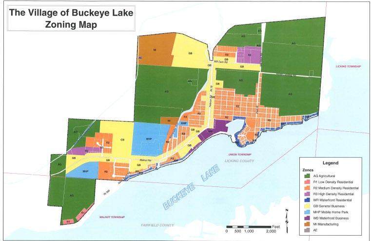
Figure 1 – Existing Zoning Map
General Observations
The existing Zoning Code is woefully unequipped to carry out the vision included in the Comprehensive Plan. The Code is out-of-date and not designed to assure the level of oversight desired for the future which calls for new development and redevelopment to be compact, walkable, and mixed-use. This deeper analysis identifies specific provisions of the Zoning Code that are ineffective, require improvement, or should be removed. However, we begin by providing general observations on the format and usability of the Zoning Code.
Subject General Observations
Organization
Graphics
Tables
Definitions
• Create an administration and procedures section, and place all procedures within this section, instead of scattering procedural information throughout the document.
• Create an introductory chapter that lays out the purpose, order of the document, conformance, effective date of adoption, etc.
• The “District” sections should contain only the permitted uses, base development standards within tables, references to the generally applicable section, and graphics as needed.
There are currently no graphics throughout the document, which should be included in districts where there is a desire to facilitate the kind of community character promoted in the Plan. The Future Typologies standards and graphics included in the “Planning Framework” section of the Comprehensive Plan would be a good starting point for inclusion of graphics to illustrate the desired development pattern of zoning districts.
Regulatory and numeric standards should be placed in a base regulation table to enable easy use and access by users of the Zoning Code.
Many definitions are missing from the definitions section. Although it will take a thorough review to assess all missing definitions, the following were observed: most forms of signage, many common developments standards, terms relating to administration, and technical terms for buildings/sites.
Improvements Necessary to Support Compact, Walkable Development.
The ideas below provide a regulatory environment that supports compact, mixed-use development built at a pedestrian scale with an emphasis on housing options and commercial vibrancy. Some of these ideas require coordination with the subdivision regulations. Others can be significantly enhanced through coordination with agencies like a business owner’s association, or with grants and incentives facilitated by the Village or Licking County Community Development Block Grant program.
Change to R-2 districts. Although provisions in Section 403 and 803 allow lots of record to be developed if they aren’t smaller than when originally platted, many of these lots are smaller than the minimum area required by the R-2 requirements (6,000 sq. ft. for one-family, 7,000 sq. ft for two-family). As a means to promote density and enable development to occur without need for variances, an inventory of the existing lot sizes for properties zoned R-2 is necessary.
Use permissions. Consider prohibiting parking lots as a primary use of a property. Parking lots do not serve as destinations for vibrant, walkable communities. Consider allowing parking lots only as accessory uses to businesses, institutions, and dwellings, thereby reducing the likelihood that valuable commercial land is used passively for temporary automobile storage.
Dimensional standards Consider implementing a maximum permitted setback from a public right-of-way to establish a consistent street wall. A maximum setback in coordination with street frontage activation standards will help emphasize pedestrian connections along the public rightof-way.
Parking standards
o Consider prohibiting parking between any buildings and the public right of way. Doing so will maintain the emphasis on walkability and pedestrian connections to active uses and destinations.
o Consider adoption of access management rules, including a comprehensive plan for the entirety of Hebron/Walnut Roads to limit future curb cuts to promote coordinated access points and/or shared drives especially in areas where vehicles cross over sidewalks or multimodal pathways. This will reduce potential conflicts between pedestrians and vehicles and increase the comfort of walking in commercial areas of the Village.
o Consider incentivizing and supporting shared parking agreements for parking lots.
o Consider establishing parking maximums to avoid the construction of more parking than is necessary This can help conserve land as well as avoid large expanses of unused paved surfaces.
o An alternative to parking maximums which is being implemented in many communities is to eliminate parking minimums altogether. Rather than establishing formulaic requirements for parking, jurisdictions allow the property owner and market forces to determine how much parking is needed while simultaneously promoting revitalization, encouraging pedestrianoriented development, reducing excessive paved surface areas, and supporting environmental sustainability. If implemented, parking standards (stall size, aisle widths, landscaping, etc.) still apply and require review by the community but the number of spaces provided are not regulated.
Bicycle Parking. To promote multi-modal transportation options, including bicycles, parking minimums could be further reduced by requiring bike parking spaces. At a minimum, bike parking facilities (i.e. racks) should be provided as part of future commercial development approvals. Consider adopting regulations to allow bike parking to replace a fraction of the minimum parking required.
Multi-modal pathways. Consider incentivizing the donation of easements for multi-modal pathways in the areas identified in the Comprehensive Plan. Incentives in the Zoning Code could include density bonuses, reduced parking requirements (if they remain in place), and review fee reductions or waivers. Consider also requiring connections to established adjacent multi-modal pathways in new developments. Further, consider requiring a minimum setback that is wide enough along planned corridors to accommodate multi-modal pathways, movable tables and chairs, bike racks, and similar public-oriented amenities. If the Village is interested in expanding the right-of-way in strategic areas to accommodate a multi-modal path, consider expressing this goal directly to supplement current and future transportation plans. Shared-use paths are typically approximately 10 feet wide, allowing sufficient space for two directions of pedestrians or cyclists at slower speeds to share a pathway.
Missing Concepts.
The following analysis identifies major concepts or ideas that are absent in the current Zoning Code These topics are not covered in the definitions or regulations and should be given consideration for inclusion in the rewrite of the Zoning Code.
Flood Hazard District. Section 800 does not appear to have a purpose. It merely requires all the various uses to follow their district’s dimensional requirements rather than requiring anything special to acknowledge location in the floodplain. Given that a large portion of the Village is located in the floodplain, at a minimum this district should contain stormwater management regulations in addition to restrictions for construction methods, materials, and locations as a means of reducing damage to investments in the event of flooding. In addition, this district is not listed on the legend of the Official Zoning Map and does not appear as a district. This district may be best implemented as an overlay zone to enable development patterns to be consistent with the vision in the Comprehensive Plan but subjected to common flood hazard regulations.
Alternative/Passive Energy Regulations. There is no mention of wind turbines or solar panels/facilities in the existing Zoning Code. Given the strong focus on energy reduction, the use of wind turbines and solar panels for on-site energy production is becoming more prevalent. Regulations that address the siting, design, operation, and similar aspects of wind energy turbines, solar panels/facilities and other passive energy collection systems should be added to the Zoning Code to enable greater energy capture potential for properties in and near Buckeye Lake.
Historic Preservation Regulations. The existing Zoning Code does not provide any method for protecting historic buildings in the Village. A goal of the Comprehensive Plan is to introduce preservation tools to enable preservation of historic buildings and sites significant to the history of the community. Such regulations would enable protection by introducing oversight measures to prohibit/encourage certain materials and to preserve the distinguishing qualities of historic features of existing structures. A wholesale set of regulations to govern such is necessary and
would also require a plan for how alterations to historic structures are reviewed. This is typically achieved through the appointment of a historic preservation professional or by the appointment of a special board to perform these reviews. While application/enforcement of such regulations is predicated on preforming the appropriate documentation of historic structures/sites in the Village, the adoption of the regulations as part of the code update would be appropriate as it would allow implementation as soon as the necessary survey work in completed.
Electric Charging Stations. Whether in a group or stand-alone, electrical charging stations will continue to be in demand as electric car usage increases. The current Zoning Code is silent on such uses. Regulations that require their approval using the least intrusive and bestcamouflaged means possible when they may be visible from the street should be considered.
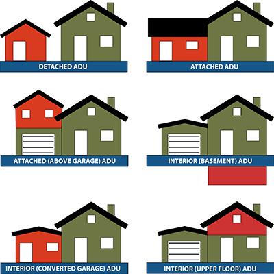
Accessory dwelling units The Zoning Code is silent on accessory dwelling units (ADU). ADUs can provide highly effective means of increasing property values and supporting populations that desire to age in place.
ADUs can take many forms but are, in essence, an individual dwelling unit located on the same property as a primary dwelling. An ADU can be attached to the primary dwelling as part of an addition, detached from a house in an accessory structure (including above a detached garage), located in an upper floor of a primary dwelling, or located in an accessible basement that provides proper ingress, egress, light, and air.
ADUs in any form can make multi-generational households more comfortable – providing space and independence for in-laws, and easier access to childcare for parents. ADUs can bring an additional source of income that provides important flexibility (or survival) for a household’s budget. And where individual property owners may choose to construct an ADU, they also end up providing different housing options that can meet the needs of a diverse range of households. For example, a single-person household may not desire to own a house or rent an apartment, but still wish to be close to a job opportunity in Buckeye Lake. Renting an ADU can be mutually beneficial, especially where the owner is aging and finds that retirement and/or social security benefits are not keeping up with rising costs; or where the owner is having difficulty affording childcare.
Some cities permit only certain kinds of arrangements for ADUs, and others allow greater flexibility. Consider permitting attached ADUs by right as an accessory use to primary dwellings on lots that meet dimensional requirements.
Marijuana/Cannabis. A cultivation and processing operation (Pharmacann) is located within the Village. Therefore, the various definitions associated with this use (both medical and recreational) should be included in the Zoning Code. Additionally, such uses should appear in a central Use Table. If the Village opts to allow or ban marijuana dispensaries in the future, they should appear in the Use Table to clarify if such is permitted, conditional, or not permitted at all.
Temporary Uses. Consider adding definitions and regulations for temporary uses. The current Zoning Code does not mention temporary uses such as garage/yard cells, festivals, short-term promotional events, etc. These uses should be defined, and regulations or clarifications added to understand how such events are regulated.
Urban Agriculture. Consider allowing for limited bee/chicken keeping and not limiting where residents can grow vegetables. Increasingly, urban residents are choosing more sustainable access to food and want to grow vegetables, keep bees, and raise chickens. Allow such uses with minimal limitations should be considered.
Telecommunication Towers. Consider adding definitions and regulations for telecommunication towers. While the State of Ohio has created some guardrails for how communities can regulate large and small cell towers, the Village does not define these uses nor does it have regulations to clarify where they are permitted. Given the growing reliance on mobile communications, standards to regulate these facilities should be created.
Bed & Breakfast. Consider adding provisions for bed and breakfast uses. Given the nature of the Village as a destination for recreation, this is a use that is likely to be desirable. A definition and standards should be added for this use.
Childcare. Consider adding references to childcare uses. The current Zoning Code fails to identify Type A and Type B (allowed in residential districts with conditions) as well as childcare centers. Given the growth pattern of the Village, it would be appropriate to define these uses as well as create standards for their review.
Figure 2 - Example ADU Arrangements (illustrated by the American Planning Association).
Environmental Performance Standards. Consider adding regulations to address stormwater management. The current Zoning Code lacks requirements for vegetated buffers, swales, watercourses, and wetlands which establish or maintain critical hydrological functions and prevent erosion and sedimentation while preserving high ground-water quality. Adding regulations to address the protection of sensitive or critical natural areas by identifying and requiring maintenance (and avoidance) of wetlands, riparian areas, water bodies, and other critical habitats would be advantageous to the Village, especially considering the degree to which flooding regularly occurs.
Recreation and Open Space Land. Consider requiring or incentivizing the development of multi-modal pathways constructed along or within recreation areas. Ideally, the Zoning Code would contain language that addresses the creation of multi-modal pathways, dedication of land for parks, playgrounds, open space, and other public sites, which potentially may include pathways. Consider explicitly requiring and/or incentivizing the establishment of multi-modal pathways in designated areas in accordance with adopted trail/recreation plans.
Ineffective or Flawed Items.
The following analysis identifies specific items or elements in the Zoning Code that are inappropriate, flawed or need to be addressed in some way.
District Descriptions. The districts lack purpose statements which can be helpful to describe the intent of the district. Additionally, in some cases, the regulations are overly complex and could be simplified by the introduction of a central Use Table and the introduction of graphic standards to indicate yard and bulk limitations.
Definitions. There are several definitions that include regulatory descriptions All applicable definitions should be revised to remove regulatory language from the definition and be replaced in the appropriate location in the Zoning Code (i.e. Home Occupation Regulations). A wholesale review of this section should occur as there are numerous definitions that should be added. For example, all the various sign types should be added. Additionally, there are no definitions for passive energy collection systems, electric charging stations, multi-modal pathways, and several other key items that are called out in the Comprehensive Plan. It would be beneficial to introduce definitions related to these elements to allow for clear regulations.
Outdated Terms/References. There are several outdated references included in the document. For example, Section 918 prohibits radioactivity (output of splitting atomic nuclei), an activity that likely violates federal and state law without issuance of a federal permit/license. These kinds of outdated references should be removed from the Zoning Code.
Church References. The term “church” is used in several locations in the document. A more appropriate term would be “religious assembly.” In a few locations, the descriptor “bona fide” is used in relation to a church. Given the broad nature of religious uses and the federal protections afforded by various religious land use cases, this descriptive term should also be avoided.
Signage Content Neutrality. The signage regulations (Section 1105) should be reviewed to determine compliance with the United States Supreme Court’s decision in Reed v. Town of Gilbert to assure content neutrality. On its surface, the regulations appear to largely meet content neutrality standards except as it relates to churches. In Section 1107, the Zoning Code makes a special exception for church directional signs allowing them to have four (4 sq. ft. each) off-premise signs located throughout the Village with permission of the property owner. This provision is a violation of the content neutrality rule and should be eliminated from the Zoning Code.
Sign Colors. The signage regulations limit signs to a maximum of five colors. There is no stated reason for this regulation and thus, has the potential to be deemed arbitrary. It could also be construed as a violation of free speech and or copyright infringement and therefore should be removed from the Zoning Code.
Abandoned Signs. In Section 1111, the Zoning Code includes regulations for abandoned signs including the right for the Village to remove signs that have been abandoned. While the nuisance abatement process is a definite legal remedy available to Ohio municipalities, a legal review to determine applicability to abandoned signs should be performed
Planned Mixed Use District. The PMUD section is a recently added section which does not appear in the Table of Contents of the Zoning Code. This section (Article 14) contains a separate set of definitions which adds unnecessary confusion and should be incorporated with the other definitions contained in the Zoning Code. Beyond this, the community should consider if including planned districts in the rewrite of the Zoning Code is necessary. Though the existing Zoning Code contains two planned district options (PDD and PMUD), none exist at present. The advantages of planned districts are that they can allow flexibility for the developer to modify components of the project for things like height, setback, building design, signage, etc. while giving the community oversight of the site and architectural designs, often negotiated through several public meetings. Many communities prefer this approach to reviewing large projects but the downside of such projects is that they introduce the need for long-term (perpetual) administrative oversight as anything on the site is modified over time. Alternatively, if the Village were to decide to omit planned districts from the future Zoning Code, a mixed-use district could be added that includes very clear and thorough standards, many of which could be derived from the existing PDD and PMUD districts. This would enable a similar development pattern typically only allowed by a planned district.
Tree & Landscaping Ordinance. Currently the Village has a separate Tree & Landscaping Ordinance. Rather than requiring applicants to reference two sets of regulations, these regulations should be incorporated into the Zoning Code.
Adult Entertainment. There is a small area in the northwest portion of the Village designated on the Official Zoning Map as “AE” for Adult Entertainment use. AE is not a district in the Zoning Code and should not appear in the list of districts on the Zoning Map. Because such uses are Conditional Uses in the Manufacturing (MI) zone, it should never appear on the Zoning Map even if approved for such use. It is recommended that the legend of the Zoning Map and the “AE” reference on the map be immediately removed.
Short Term Rentals. The Village has a separate ordinance governing the use and regulation of short-term rentals. This ordinance may remain as a separate ordinance or can be incorporated into the updated Zoning Code. In either case, a definition for short-term rental should be added to the Zoning Code.
Minimum Floor Area. In the Agriculture and Residential districts, the code sets minimum building square foot areas for residences. Consider reducing square footage minimum requirements, or eliminate them altogether, as they have a direct effect on pricing out potential property owners. They can also limit options for creative approaches to housing typologies found in the current marketplace. Many communities have eliminated these minimums, and this approach should be considered by Buckeye Lake.
ODOT Review. In two places, Section 303 and Section 605, for Zoning Permits and Zoning Amendments, the Zoning Code requires ODOT review of proposed developments and zone amendments for properties located within a specific distance of a proposed new highway or an existing highway where changes are proposed. The language included in these Sections is codified in the Ohio Revised Code and does not need to be repeated in the Zoning Code for emphasis. If a new roadway were planned or there was a substantial amount of undeveloped land in the jurisdiction that may necessitate the State to build a new road, this language may have some use. As is, the Sections have no applicability and should be removed.
Application Requirements. In various locations (Section 301, 512, 520, 603), the application requirements for things like obtaining a zoning permit and for filing a BZA appeal, conditional use application, etc. are enumerated in the Code. These requirements are best found in the application itself. As such, they can be easily modified/adjusted as needed rather than needing to amend the Zoning Code when minor changes are needed. These lists should be removed.
Duties of the Planning Commission. Section 503 identifies the duties of the Planning Commission. This Section fails to mention that the Planning Commission is the platting (subdivision) authority. Additionally, number 3 in this Section should be amended to indicate that the Planning Commission makes recommendations to the Village Council on Planned Mixed Use Developments as well. This was likely an oversight when Article 14 was added to the Code.
Zone Amendments. Article 6 contains the process for amending the text and map of the Zoning Code. However, Section 606 fails to point out that the review by the Planning Commission necessitates a public hearing Though the recommendation to the Village Council is an advisory recommendation, it should come after notifying surrounding property owners and soliciting public input. As written, it’s not clear that public input is required at all before a recommendation is made to the Village Council.
Annexations. Section 612 identifies the zoning designation for annexed land. As written, it retains the zoning designation from the Township. While it is not uncommon for land to remain under the previous community’s zoning classification upon annexation, this is not necessarily the most prudent approach as it requires a community to review/enforce regulations from another community. It would be more expedient to automatically classify it as either Agriculture or the largest single family residential classification. In this way, the land would be governed by the regulations of Buckeye Lake rather than another jurisdiction.
BZA Appeals. Section 512 identifies the standards for variances. While standards are identified in Section 512(4), it would be advisable to modify this section to include the Duncan standards. As written, it’s not clear if the community only hears bulk/height/dimensional variances or if use variances are also considered. If so, the differing sets of standards for each should be enumerated in the Code to make clear the distinct standards used for the differing situations.
Erosion. Section 923 does not contain any standards for review, nor does it reference another set of rules/regulations (i.e. Licking County) that applicants must follow. It is essential that new developments and redevelopment projects follow proper erosion control methods and therefore, the Village should consider adopting such regulations and referencing them in their Code update.
Parking Requirements. Article 10 is titled “Off-Street Parking and Loading Requirements for R3, General Business and Manufacturing Districts” suggesting that it does not apply to any use outside these districts. In cases where non-residential uses such as a church is located in a residential district, currently compliance with parking standards does not apply. This Article should be retitled “Off-Street Parking and Loading Requirements” to apply universally across all uses in the Village. Additionally, Section 1017 contains a page of uses listed by general category and the minimum number of parking spaces required. Unless the Village decides to eliminate parking minimums as discussed earlier in this document, a simpler approach like the example provided below should be considered. This approach reduces parking requirements
and preserves property for development rather than building parking lots that are larger than necessary.
Figure 3 - Example Parking Requirement Table
Type of Use
(Regardless of District)
Minimum Required Parking Spaces
Residential Uses 1 space per unit (1)
Commercial and Office Uses 1 space per 500 square feet of gross customer service floor area
Industrial Uses 1 space per 5,000 square feet of gross non-warehouse floor area
Mixed-Use Buildings 1 space per 600 square feet of gross floor area
Public Uses
Table Notes:
Decided by the Planning Commission
(1) A unit is a residential dwelling, not the number of bedrooms within a residential dwelling.
Diagrams would be helpful to avoid long descriptions of various parking lot requirements. Lastly, parking lot lighting, though required by Section 1006, does not contain any standards Establishing limits for the height of poles, maximum lumens at the property line, etc. should be considered.
Supplemental Standards. Article 9, in general, should be updated to include many additional, common supplemental standards commonly found in modern zoning regulations. A wholesale review and update to this portion of the Code is recommended.
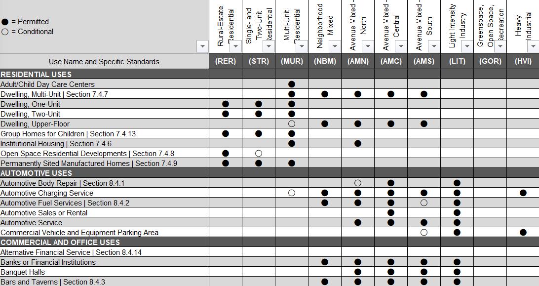
Comprehensive Use Table. Consider building a comprehensive principal use permissions table that shows in one place all the permitted principal uses across each district (see Figure 4Example Comprehensive Use Permissions Table).
Figure 4 - Example Comprehensive Use Permissions Table
Where the Zoning Code includes lists of permissions within each district, a comprehensive table provides one consistent reference point for all use permissions – making administration more efficient and interpretation more consistent. Such a table would combine the information for conditionally permitted uses with by-right permitted uses. Consider having an excerpt table within sections of the zoning code for each district that defers to the comprehensive table. This approach (a comprehensive table with excerpts) organizes the information to provide a userfriendly experience for two different perspectives of users: current property owners looking to improve or expand their building or potential developers looking to invest for the first time in Buckeye Lake.
Subdivision Regulations. Consider reviewing the current Subdivision Regulations to determine if the design standards are appropriate to achieve the desired outcome identified in the Comprehensive Plan. At present, it appears that the Village has adopted the Licking County Subdivision Regulations which may be more appropriate for a suburban development pattern and may not be able to address the compact nature of the Village and the desire to promote walkability and mixed-use development patterns.
Conclusion
The ideas presented above highlight potential adjustments that will simplify zoning processes and remove barriers for desired investments and development. These suggestions include developing comprehensive tables, consolidating uses into categories, improving organization, and updating illustrations. Collectively, these recommended changes will help property owners navigate the Zoning Code and produce better outcomes in the built environment of Buckeye Lake.
Proposed Table of Contents
The following is an example of how the Village’s updated Zoning Code could take shape. This is intended to be illustrative and is for discussion purposes only.
Article 1. Introduction to and How to Use the Code
1.01 Authority and Title
1.02 Minimum Requirements and Relationship Between Provisions
1.03 Purpose and Intent
1.04 Comprehensive Plan
1.05 Zones, Districts, and Overlays Established
1.06 Zoning Map
1.07 Rules for Interpreting Zoning Boundaries on the Zoning Map
1.08 Severability and Repeal
1.09 Rules of Measurements and Calculation
1.10 Permitted Encroachments into Required Setbacks
1.11 Rules of Interpretation
1.12 How to Use this Code
Article 2. Zones, Districts and Subdistricts*
2.01 Introduction
2.02 Zones
2.03 Districts
2.04 Overlay Districts
Each of the above Districts and Zones will include the following: Purpose and Intent Permitted and Conditional Uses* Lot and Setbacks Building and Design Standards
*Include reference to special use standards and conditional use standards
Article 3. Supplemental Use Standards
3.01 Purpose and Applicability
3.02 Mobile Homes
3.03 Accessory Dwelling Units (ADU)
3.04 Childcare (Type A, Type B, Centers)
3.05 Telecommunications Towers and Facilities
3.06 Electric Charging Stations
3.07 On-site Energy Production (Wind/Solar)
3.08 Home Occupations
3.09 Bed and Breakfasts and Short-term Rentals
3.10 Adult Entertainment Uses
3.11 Private Swimming Pools and Community or Club Swimming Pools
3.12 Portable Storage Units
3.13 Private Non-Commercial Garages
3.14 Temporary Uses
3.15 Temporary Construction-Related Structures
3.16 Medical (and/or Recreational) Marijuana
Article 4. Generally Applicable Regulations
4.01 Performance Standards
4.02 Accessory Uses and Structures
4.03 Lighting
Article 5. Landscaping, Screening, and Buffering
5.01 Purpose and Applicability
5.02 Landscape Plan Requirements
5.03 Tree Preservation
5.04 Street Tree Requirements
5.05 Perimeter Landscape Requirements
5.06 Bufferyard Requirements
5.07 Landscape Materials
5.08 Screening in Commercial or Industrial Districts
Article 6. Parking, Loading, and Drive-Throughs
6.01 Purpose and Applicability
6.02 Minimum Parking Space Schedule
6.03 Reductions to Minimum Parking Space Schedule
6.04 Minimum Parking Space Dimensions
6.05 Pick-Up and Drop-Off Parking Spaces
6.06 Shared Parking Spaces
6.07 Location of Parking Areas
6.08 Bicycle Parking
6.09 Pedestrian Walkways in Parking Areas
6.10 Parking Area Surfaces
6.11 ADA Parking Requirements
6.12 Parking Lot Landscaping
6.13 Drive-Through Standards
6.14 Loading Standards
Article 7. Sign Regulations
7.01 Purpose and Scope
7.02 Signs Permitted in all Zones
7.03 Prohibited Signs and Sign Elements
7.04 Regulations Applicable to all Sign
7.05 Sign Standards by Zone
7.06 Special Use Signs
7.07 Nonconforming Signs
7.08 Off-Premises Signs
Article 8. Administration and Procedures
8.01 Zoning Inspector/Administrator
8.02 Board of Zoning Appeals
8.03 Planning Commission
8.04 Zoning Permits and Applications
8.05 Appeals of Administrative Decisions
8.06 Variance Permits and Applications
8.07 Conditional Use Permits and Applications
8.08 Substantially Similar Uses
8.09 Zoning Map Amendments
8.10 Zoning Text Amendments
Article 9. Nonconformities
9.01 Continuance or Discontinuance
9.02 Determination of Vacancy or Abandonment
9.03 Restoration
9.04 Expansion or Substitution
9.05 Improvement on a Nonconforming Lot
9.06 Elimination of Nonconforming Status
Article 10. Enforcement
10.01 Violations
10.02 Remedies
10.03 Penalty
Article 11. Glossary of Terms (All definitions in this Article)