BG
Bowling Green
Zoning Code
Bowling Green
Zoning Code
This Chapter 150 shall be known and cited as the “City of Bowling Green Land Use and Development Code” and may be referred to herein as the “Zoning Code.”
This Zoning Code was adopted on June 12, 2023, with an effective date of July 12, 2023.
No regulation contained herein shall require any change in the overall layout, plans, construction, size, or designated use of any development, structure, or part thereof, for which official approvals and required zoning permits have been granted before the enactment of this Zoning Code, and the construction of which, conforming with such plans, shall have been started prior to the effective date of this Zoning Code, or within 30 days thereafter, and completion thereof carried on in a normal manner within the subsequent 12-month period and not discontinued until completion except for reasons beyond the owner’s control.
The purpose of this Zoning Code is to promote the public health, safety, and general welfare; to facilitate the provision of public utilities, schools, and other public requirements; to promote the preservation of historic resources; and to promote Bowling Green’s investment in building attractive, walkable, and vibrant neighborhoods.
A. No structure or land shall hereafter be used or occupied, and no structure or part hereof shall hereafter be erected, constructed, reconstructed, moved, or altered unless in conformity with all the provisions of this Zoning Code and after the lawful issuance of all permits and certificates required by this Zoning Code.
B. Lots created after the effective date of this Zoning Code shall comply with the requirements of this Zoning Code.
C. No building, site, or structure which is within a designated Historic Overlay Zone, as defined in Section 158.03 (M) of the City of Bowling Green Codified Ordinances, shall be erected or altered until a Certificate of Appropriateness has been granted by the Historic Preservation Commission.
D. All ordinances or parts of ordinances in conflict with this Zoning Code or inconsistent with the provisions of this Zoning Code are hereby repealed to the extent necessary to give this Zoning Code full force and effect.
E. The provisions of this Zoning Code are not intended to nullify, abolish, or repeal any easement, covenant, or other private agreement or restriction.
Should any section or provision of this Zoning Code be declared by the courts to be unconstitutional or invalid, such decision shall not affect the validity of the Zoning Code as a whole, or any part thereof other than the part so declared to be unconstitutional or invalid.
A. Whenever a defined word appears in this Zoning Code, its meaning is as defined in this Zoning Code. Words not defined in this Zoning Code are interpreted in accord with their dictionary meaning and customary usage.
B. All references to other regulations or manuals shall refer to the most current version and citation for those regulations or manuals, unless expressly indicated otherwise. When the referenced regulations or documents have been repealed and not replaced by other regulations or manuals, such reference or requirement for compliance is no longer in effect.
C. Illustrations, diagrams, and flowcharts are included in this Zoning Code to illustrate the intent and requirements of the text. In the case of a conflict between the text and any illustration, diagram, or flowchart, the text shall control.
D. The language of this Zoning Code shall be interpreted as follows:
(1) The w ord “person” includes a firm, association, organization, partnership, trust, limited liability company, corporation, or other legal entity, as well as an individual.
(2) The present tense includes the future tense; the singular number includes the plural; and the plural number includes the singular in each case if the context so requires.
(3) The w ord “shall” is mandatory; the word “may” is permissive.
(4) The wor ds “used” or “occupied” include the words “intended,” “designed,” “constructed,” “altered,” or “arranged” to be used or occupied.
(5) The w ord “lot” includes the words “plot,” “tract,” or “parcel.”
(6) The terms “standards,” “regulations,” and “requirements” are used to mandate a specific course of action or built outcome.
E. Section headings are provided for ease of use and organization and shall not be interpreted as regulatory.
F. Where a regulation involves two or more items, conditions, provisions, or events which are connected by a conjunction—”and,” “or,” or “either...or“— the conjunction shall be interpreted as follows:
(1) “And” indicates that all the connected items, conditions, provisions, or events shall apply.
(2) “Or” indicat es that the connected items, conditions, provisions, or events may apply singularly or in any combination.
(3) “Either... or” indicates that all the connected items, conditions, provisions, or events shall apply singularly but not in combination.
G. In the case of any conflict or inconsistency between two or more provisions of this Zoning Code or any other City ordinance, law, rule, or regulation, the provision which imposes the greater, higher, or more restrictive requirement or standard of performance shall control.
Step One: Locate your property and applicable zoning district on the Zoning Map.
Step Two: Locate the applicable zone or district regulations in Article II.
Step Three: Determine what uses are allowed in the zone or district in Article III.
Step Four: Determine if any generally applicable regulations apply in Article IV.
Step Five: Determine if any nonconformities exist and how to address them in Article V.
Step Six: Determine if any approvals are necessary and how to apply for them in Article VI.
This article provides standards for regulating lot and building dimensions.
A. Establishment of Zones and Districts. The zones and districts described in this article are hereby established.
B. Historic Overlay Zone. The Historic Overlay Zone may, from time to time, be designated or expanded in accordance with Chapters 150 and 158.
(1) Effect of De signation. The Historic Overlay Zone shall be applied to individually Listed Properties and/or Historic Districts. Once local historic designation is approved by City Council, the Planning Director must cause the historic designation to be shown on the official zoning map as a Historic Overlay Zone, without changing the base zone or district. Whenever there is a conflict between regulations applicable in a base zone or district and the regulations of the historic designation, the more restrictive will apply.
(2) Certifica tes of Appropriateness (COA). No contractor, owner, or agent of the owner may make any alterations as defined in Section 158.03 (A) to any Listed Property or Historic District unless a valid written COA has been issued by the Historic Preservation Commission. The COA procedures are listed in Section 158.07.
(3) Standar ds for the Treatment of Historic Properties. The U.S. Secretary of the Interior’s Standards for the Treatment
of Historic Properties have been adopted pursuant to Section 158.07. Compliance with the U.S. Secretary of the Interior’s Standards for the Treatment of Historic Properties is required for all Listed Properties and Historic Districts.
(4) Decisions. Decisions reached by the Historic Preservation Commission will be based on the Historic Preservation Commission’s interpretation of the U.S. Secretary of the Interior’s Standards for the Treatment of Historic Properties and the testimony of the applicant and other interested parties.
C. Adoption of the Zoning Map. The City of Bowling Green Zoning Map is hereby adopted and incorporated into this Zoning Code by reference. Each parcel of land within the city is classified under a zone or district hereby established by and designated on the Zoning Map. The Zoning Map shall be maintained on file in the City offices and updated on the City’s official website. No changes of any kind shall be made to the Zoning Map or any part thereof except in conformity with the procedures set forth in this Zoning Code.
A. Boundaries indicated as approximately following the centerlines of streets, highways, or alleys shall be construed to follow such centerlines.
B. Boundaries indicated as approximately following platted lot lines shall be construed as following such lot lines.
C. Boundaries indicated as approximately following city limits shall be construed as following such city limits.
D. Boundaries indicated as following rail lines shall be construed to be midway between the main tracks.
E. Boundaries indicated as parallel to or extensions of features listed above shall be so construed.
F. Distances not specifically indicated on the Zoning Map shall be determined by the scale of the map.
G. Where physical or cultural features existing on the ground are at variance with those shown on the Zoning Map, or in other circumstances not covered herein, the Planning Director or their designee shall interpret the district boundaries.
H. Where the street or lot layout actually on the ground or as recorded differs from the street or lot layout on the district map, the Zoning Board of Appeals shall, after notice to property owners affected, and after public hearing, interpret the map in such a way as to carry out the intent and purpose of this Zoning Code.
I. Where a zone or district boundary line divides a lot which was in single ownership at the time of passage of this Zoning Code, the Zoning Board of Appeals may permit, as a conditional use, the extension of the regulations for either
portion of the lot, but not to exceed fifty (50) feet beyond the zoning district line as drawn, into the remaining portion of the lot.
J. Whenever any street, alley, or other public way is vacated by official action of City Council, the boundary line(s) of any adjacent zone or district shall extend to the centerline of the vacated street, alley, or public way.
A. Structure height is the vertical distance between the average grade plane of the structure and the highest point of any flat roof or the midpoint of any pitched roof.
B. The height regulations prescribed herein shall not apply to telecommunications facilities, church spires, belfries, monuments, tanks, water and fire towers, cooling towers, ornamental towers and spires, cupulas, chimneys, elevator bulkheads, smokestacks, conveyors, and flagpoles, except where the height of such structures will constitute a hazard to the safe landing and takeoff of aircraft at an established airport.
ACCESSORY STRUCTURE
ACCESSORY STRUCTURE
PRINCIPAL STRUCTURE
PRINCIPAL STRUCTURE
STREET RIGHT-OF-WAY
INTERIOR LOT CORNER LOT
STREET RIGHT-OF-WAY
Figure 2: Illustrative graphic showing lot lines for an interior lot and a corner lot.
A. Lot Line. A lot line is a line dividing one lot from another lot or from a street or any public place.
B. Front Lot Line. A front lot line is a lot line dividing a lot from a public or private street and is the line from which the required front setback is measured. If a lot has more than one lot line that abuts a street right-of-way, such as is the case with a corner lot, the lot may have more than one front lot line. FLL
C. Side Lot Line. A side lot line is any lot line not considered a front lot line or a rear lot line. SLL
D. Rear Lot Line. The rear lot line is the lot line which is most opposite the front lot line. Each lot shall have one rear lot line. RLL
(1) In the case of a corner lot with more
than one fr ont lot line, the rear lot line is the lot line which is most opposite the shortest front lot line.
(2) In the case of an irregular or triangular-shaped lot, the rear lot line is a line 10 feet in length within the lot situated parallel to and at the maximum distance from the front lot line.
Lot Width. The lot width is the length of a lot’s shortest front lot line. LW
A. Lot Area. The lot area is the area of a horizontal plane bounded by vertical planes extending from the lot lines of a single lot, and not including any area within the right-of-way.
ACCESSORY STRUCTURE
PRINCIPAL STRUCTURE
PRINCIPAL STRUCTURE
Figure 3: Illustrative graphic showing yard setbacks and lot widths for an interior lot and a corner lot.
B. Lot Coverage. Lot coverage is the percentage of the total lot area that is covered by man-made surfaces, such as principal structures; accessory structures over 100 square feet, such as patios, decks, garages, carports, and pools; and other surfaces, such as driveways, sidewalks, parking lots, and areas of gravel, pavers, or pavement; but excluding service walks.
A. Front Yard Setback. A front yard setback is the shortest horizontal distance between a structure and the edge of the right-of-way. FYS
B. Side Yard Setback. A side yard setback is the shortest horizontal distance between a structure and a side lot line of the lot. SYS
C. Rear Yard Setback. A rear yard setback is the shortest horizontal distance between a structure and a rear lot line of the lot. RYS
D. Exceptions to Setbacks
(1) Open or lattice-enclosed fire escapes, outside stairways, balconies opening upon fire towers, and the ordinary projections of chimneys and flues into a rear yard may extend rearward of a principal structure by up to five horizontal feet.
(2) Ramps built t o provide wheelchair accessibility to entrances of dwellings are exempt from the setback requirements.
A. Irrespective of any other provision of this Zoning Code, no building or other STREET RIGHT-OF-WAY
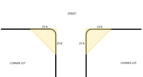
structure or fence or planting, of greater than two feet in height, shall be erected or maintained in any zone or district within a vision clearance triangle, except for at intersections controlled by traffic signals within the Central Business District.
B. A vision clearance triangle is present at all corners of intersecting streets. Each vision clearance triangle has two sides that commence at the corner of the corner lot. Each of these two sides extends 25 feet away from the corner along each lot line. The ends of these two sides are connected with a hypotenuse, forming the third side.
C. No vision clearance triangle is required for unimproved or unpaved alleys.
A. Residential Density. The residential density of a lot (RD) is equal to the number of dwelling units on the lot (DU) divided by the acreage of the lot (A).
RD = DU/A
For example, if two dwelling units are located on a lot of 0.5 acres, the residential density is equal to 2 units/0.5 acres, or four units per acre.
B. Minimum residential density regulations apply to structures erected after the adoption of this Zoning Code. Minimum residential density regulations do not apply to existing structures.
A lot within any district or zone shall be occupied only by one (1) principal structure, unless waived by specific provisions of a district or zone.
A zone is intended to promote harmonious land uses within a geographic area by limiting the use, placement, and scale of structures within that zone. One zoning designation may be applied to numerous, non-contiguous geographies across the city that share existing or desired development patterns.
Low Density Residential Zone (R-1)Medium Density Residential Zone (R-2)
The Low Density Residential Zone intends to preserve low density residential neighborhoods that are characterized by one-unit dwellings and adequate open space.
The Medium Density Residential Zone intends to maintain medium density residential neighborhoods with a mix of one-unit and two-unit dwellings.
The Multi-Unit Residential Zone intends to maintain high density residential neighborhoods with multi-unit dwellings.
Commercial Zone (C) Innovation and Employment Zone (IE) Mixed-Use Neighborhood Zone (MUN)
The Commercial Zone promotes a mix of lot sizes and uses to provide nearby residents with convenient access to shops, services, and employment opportunities.
The Innovation and Employment Zone promotes a broad mix of commercial and industrial uses that support economic activity by supplying services, products, innovations, and employment.
Institutional Zone (I) Agricultural Zone (A-1)
The Institutional Zone promotes institutional land uses, including schools, libraries, the public hospital, government offices and facilities, and centers for arts and sciences.
The Agricultural Zone intends to preserve the agricultural character of Bowling Green with large lots for agricultural production.
The Mixed-Use Neighborhood Zone promotes a mix of residential and commercial uses to provide residents with convenient access to shops, services, and employment opportunities within their neighborhood.
Recreational-Conservation Zone (R-C)
The Recreational-Conservation Zone protects and perpetuates a system of permanent parks and recreational areas for residents.
Low Density Residential Zone
Figure 5: The Low Density Residential Zone may include many distinct geographies, such as the area emphasized in the image above. For the complete Zoning Map, visit https://www.bgohio.org/departments/planning-department/zoning-map.
A. Intent. The Low Density Residential Zone intends to preserve low density residential neighborhoods that are characterized by one-unit dwellings and adequate open space.
B. Lot, Building, and Design Standards. Lot, building, and any applicable design standards are set forth in the following table.
C. Uses and Use Standards. Land in this zone may be used only for permitted and conditionally permitted land uses. Uses and use standards are set forth in Article III.
Lot Area 7,200 sq. ft. min.
Lot Width 60 ft. min.
Front Yard Setback25 ft. min.
Side Yard Setback10 ft. min.
Rear Yard Setback30 ft. min.
Structure Height35 ft. max.
Lot Coverage 50% max.
Permitted Sign TypesSee Section 150.82 for sign standards.
Table 1: Regulatory standards for lots in the R-1 Zone.
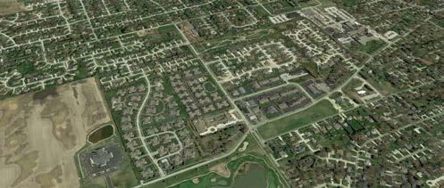
Figure 6: The Medium Density Residential Zone may include many distinct geographies, such as the area emphasized in the image above. For the complete Zoning Map, visit https://www.bgohio.org/departments/planning-department/zoning-map.
A. Intent. The Medium Density Residential Zone intends to maintain medium density residential neighborhoods with a mix of one-unit and two-unit dwellings.
B. Lot, Building, and Design Standards. Lot, building, and any applicable design standards are set forth in the following table.
C. Uses and Use Standards. Land in this zone may be used only for permitted and conditionally permitted land uses. Uses and use standards are set forth in Article III.
Lot Area 5,000 sq. ft. min.
Lot Width 40 ft. min.
Front Yard Setback20 ft. min.
Side Yard Setback5 ft. min. on at least 1 side
Rear Yard Setback20 ft. min.
Structure Height40 ft. max.
Lot Coverage 65% max.
Permitted Sign TypesSee Section 150.82 for sign standards.
Table 2: Regulatory standards for lots in the R-2 Zone.
Multi-Unit Residential Zone
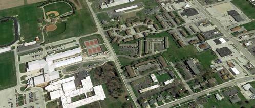
Figure 7: The Multi-Unit Residential Zone may include many distinct geographies, such as the area emphasized in the image above near Bowling Green High School. For the complete Zoning Map, visit https://www.bgohio.org/departments/planningdepartment/zoning-map.
A. Intent. The Multi-Unit Residential Zone intends to maintain high density residential neighborhoods with multi-unit dwellings.
B. Lot, Building, and Design Standards. Lot, building, and any applicable design standards are set forth in the following table.
C. Uses and Use Standards. Land in this zone may be used only for permitted and conditionally permitted land uses. Uses and use standards are set forth in Article III.
Lot Width 60 ft. min.
Front Yard Setback20 ft. min.
Side Yard Setback20 ft. min.
Rear Yard Setback20 ft. min.
Structure Height45 ft. max.
Lot Coverage 65% max.
Permitted Sign TypesSee Section 150.82 for sign standards.
Balcony LocationPermitted on any elevation.
Table 3: Regulatory standards for lots and structures in the R-3 Zone.
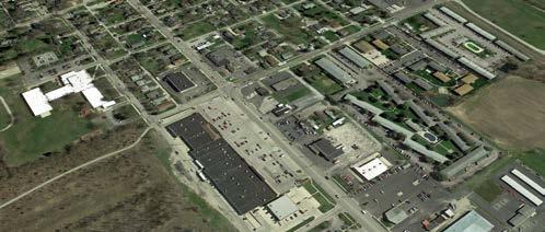
Figure 8: The Commercial Zone may include many distinct geographies, such as the area emphasized in the image above. For the complete Zoning Map, visit https://www.bgohio.org/departments/planning-department/zoning-map.
A. Intent. The Commercial Zone promotes a mix of lot sizes and uses to provide nearby residents with convenient access to shops, services, and employment opportunities.
B. Lot, Building, and Design Standards. Lot, building, and any applicable design standards are set forth in the following table.
C. Uses and Use Standards. Land in this zone may be used only for permitted and conditionally permitted land uses. Uses and use standards are set forth in Article III
Lot Width 30 ft. min.
Front Yard Setback0 ft. min.
Side Yard Setback10 ft. min.
Rear Yard Setback20 ft. min.
Structure Height25 ft. min.; 45 ft. max.
Lot Coverage 80% max.
Permitted Sign TypesSee Section 150.82 for sign standards.
Storefront Fenestration for Corner Lots
Storefront fenestration must wrap around the corner of the building and continue for at least 10 ft. along the side street frontage.
Table 4: Regulatory standards for lots and structures in the C Zone.
Innovation and Employment Zone
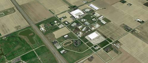
Figure 9: The Innovation and Employment Zone may include many distinct geographies, such as the area emphasized in the image above. For the complete Zoning Map, visit https://www.bgohio.org/departments/planning-department/zoning-map.
A. Intent. The Innovation and Employment Zone promotes a broad mix of commercial and industrial uses that support economic activity by supplying services, products, innovations, and employment.
B. Lot, Building, and Design Standards. Lot, building, and any applicable design standards are set forth in the following table.
C. Uses and Use Standards. Land in this zone may be used only for permitted and conditionally permitted land uses. Uses and use standards are set forth in Article III.
Lot Width100 ft. min.
Front Yard Setback 35 ft. min.
Table 5: Regulatory standards for lots and structures in the IE Zone.
Side Yard Setback
20 ft. min. when not abutting dwelling use or residential zone or district; at least one foot for every one foot of building height or 20 ft., whichever is greater, when abutting a dwelling use or residential zone or district.
Rear Yard Setback
Structure Height
20 ft. min. when not abutting dwelling use or residential zone or district; at least one foot for every one foot of building height or 20 ft., whichever is greater, when abutting a dwelling use or residential zone or district.
80 ft. max., except that structures may exceed 80 ft. of height if they provide an extra 0.5 ft. of side and rear yard setback for each 1 ft. of height exceeding 80 ft.
Lot Coverage 70% max.
Permitted Sign Types See Section 150.82 for sign standards.
Mixed-Use Neighborhood Zone
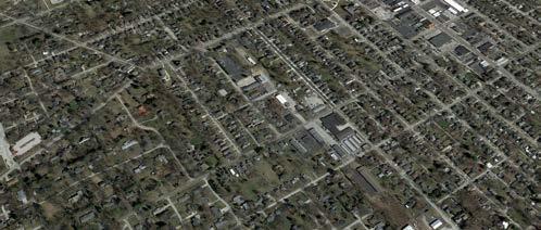
Figure 10: The Mixed-Use Neighborhood Zone may include many distinct geographies, such as the area emphasized in the image above. For the complete Zoning Map, visit https://www.bgohio.org/departments/planning-department/zoning-map.
A. Intent. The Mixed-Use Neighborhood Zone promotes a mix of residential and commercial uses to provide residents with convenient access to shops, services, and employment opportunities within their neighborhood.
B. Lot and Building Standards. Lot and building standards are set forth in the following table.
C. Uses and Use Standards. Land in this zone may be used only for permitted and conditionally permitted land uses. Uses and use standards are set forth in Article III.
D. Design Standards. All structures, except one- and two-unit dwellings, in the Mixed-Use Neighborhood (MUN) Zone that are newly developed, redeveloped, or undergoing facade renovations that affect more than 25% of the front facade after the effective date of this ordinance must comply with the following design standards.
Lot Width30 ft. min.
Lot Depth100 ft. min.
Front Yard Setback 0 ft. min.
Side Yard Setback 0 ft. min. if not adjacent to residential use; 10 ft. min. if adjacent to residential use
Rear Yard Setback 20 ft. min.
Structure Height 45 ft. max.
Lot Coverage 80% max.
Permitted Sign Types See Section 150.82 for sign standards.
Table 6: Regulatory standards for lots and structures in the MUN Zone.
Building Facade Articulation
Building Facade Materials
The entirety of street-facing building elevation must be articulated using one or more of the following techniques: (1) the building facade varies in color, material, or pattern at least every 40 linear ft. along the street, or (2) at least 20% of the building’s front elevation shall be set back at least 18 inches less or more than the remainder of the front elevation.
The entirety of street-facing building facades must consist of brick, stone, wood, or cement board.
Building RooflinesThe predominant roof form shall be flat and parapeted. Vertically projecting elements or elevated sloped roof forms are allowed at prominent building corners. Roofs shall be considered a visible elevation and shall be designed with features, materials and patterns that reflect the character of the building.
Building CornersBuilding corners should be emphasized through change of materials or patterns, stepping back at the corners, building projections, or additional height. Where additional height is used as a corner emphasis, the corner may exceed the maximum building height by up to 10 ft.
Floor-to-Floor HeightsFor retail uses, street-level floors must maintain at least 16 ft. of floor-to-floor height
Building TransparencyFor retail uses, street-level facades must maintain at least 50% transparency; for retail uses, street-level window sills shall be no higher than 3 ft. above the adjacent sidewalk and tops of windows shall be no less than 10 feet above the adjacent sidewalk. For residential uses, street-level and upper-level facades must maintain at least 10% transparency.
Building Mechanical Equipment No building mechanical equipment, such as HVAC compressors, heat exchangers, water towers, or exhaust fans, may be located within 20 feet of the street-fronting façade or corner. Any building mechanical equipment must be screened from view from any adjacent street using screening material with at least 50% opacity.
Outdoor StorageAny outdoor area used for waste storage or material storage must be screened from view from the right-of-way using 6-ft-high evergreen vegetation or a 6-ft-high, opaque fence.
Table 7: Design standards for all structures, except one- and two-unit dwellings, in the MUN Zone that are newly developed, redeveloped, or undergoing facade renovations that affect more than 25% of the front facade after the effective date of this ordinance.
Institutional Zone
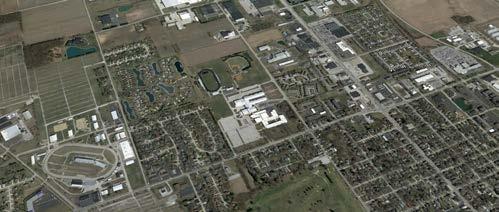
Figure 11: The Institutional Zone may include many distinct geographies, such as the area emphasized in the image above. For the complete Zoning Map, visit https://www.bgohio.org/departments/planning-department/zoning-map.
A. Intent. The Institutional Zone promotes institutional land uses, including schools, libraries, the public hospital, government offices and facilities, and centers for arts and sciences.
B. Lot, Building, and Design Standards. Lot, building, and any applicable design standards are set forth in the following table.
C. Uses and Use Standards. Land in this zone may be used only for permitted and conditionally permitted land uses. Uses and use standards are set forth in Article III.
Front Yard Setback50 ft. min.
Side Yard Setback10 ft. min.
Rear Yard Setback20 ft. min.
Structure Height60 ft. max.
Permitted Sign TypesSee Section 150.82 for sign standards.
Table 8: Regulatory standards for lots and structures in the I Zone.
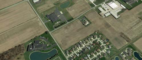
Figure 12: The Agricultural Zone may include many distinct geographies, such as the area emphasized in the image above. For the complete Zoning Map, visit https://www.bgohio.org/departments/planning-department/zoning-map.
A. Intent. The Agricultural Zone intends to preserve the agricultural character of Bowling Green with large lots for agricultural production.
B. Lot, Building, and Design Standards. Lot, building, and any applicable design standards are set forth in the following table.
C. Uses and Use Standards. Land in this zone may be used only for permitted and conditionally permitted land uses. Uses and use standards are set forth in Article III.
Lot Area
43,560 sq. ft. (1 acre) min.
Front Yard Setback40 ft. min.
Side Yard Setback40 ft. min.
Rear Yard Setback40 ft. min.
Lot Coverage 70% max.
Permitted Sign TypesSee Section 150.82 for sign standards.
Table 9: Regulatory standards for lots in the A-1 Zone.
Recreational-Conservation Zone
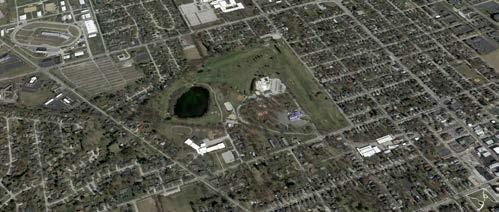
Figure 13: The Recreational-Conservation Zone may include many distinct geographies, such as the area emphasized in the image above. For the complete Zoning Map, visit https://www.bgohio.org/departments/planning-department/zoning-map/.
A. Intent. The Recreational-Conservation Zone protects and perpetuates a system of permanent parks and recreational areas for residents.
B. Lot, Building, and Design Standards.
The R-C Zone shall be developed and maintained in accordance with the following:
(1) The pre servation and appropriate management of timber and wildlife habitats shall be encouraged.
(2) The planting of vegetation for erosion control and wildlife habitat shall be encouraged.
(3) Land managemen t to reduce nonnative species shall be encouraged.
(4) Struct ures shall be constructed and situated so as to minimize their effect on scenic views, prevent the threat of pollution of waterways, and to complement the topography of the land in order to utilize natural contours and reduce required grading.
(5) A public re view process will be followed for all new structures located within the R-C Zone, according to guidelines established by the Parks and Recreation Board or any other governing authority, if applicable.
(6) Lands in the R-C Dis trict are considered permanent recreational areas.
(7) Building standards are set forth in the following table. These standards do not apply to walking or biking paths.
Front Yard Setback25 ft. min.A
Side Yard Setback25 ft. min.A
Rear Yard Setback25 ft. min.A
Structure Height35 ft. max.
Table 10: Regulatory standards for lots in the R-C Zone.
AWhen abutting a lot that permits dwelling units by-right, the setback shall be 50 ft. min.
C. Uses and Use Standards. Land in this zone may be used only for permitted and conditionally permitted land uses. Uses and use standards are set forth in Article III.
A district is a distinct area of the city with a unique identity and purpose, whether existing or desired. District regulations aim to respect the district’s unique identity and purpose through context-specific land use restrictions, building placement and scale regulations, and design standards.
Pedestrian-Residential District (PR)

The Pedestrian-Residential District promotes walkable neighborhoods with residential uses and some associated businesses. Residents in this district should be able to walk quickly, safely, and peaceably to nearby businesses.
University-Oriented Residential District (UR)

The University-Oriented Residential District promotes a mix of residential and commercial uses within walking distance of Bowling Green State University.

The Central Business District promotes the vitality of Bowling Green’s historic downtown with buildings close to the street, shopfronts with transparent facades, and a broad mix of uses.
The Bowling Green Gateway District promotes the development of a higher intensity, urban neighborhood center along E. Wooster Street, serving as a gateway and vibrant connection between Bowling Green State University and Downtown Bowling Green.
Interstate Commerce District (IC)

The Interstate Commerce District intends for a mix of lodging, commercial retail, and auto-oriented services.
Pedestrian-Residential District
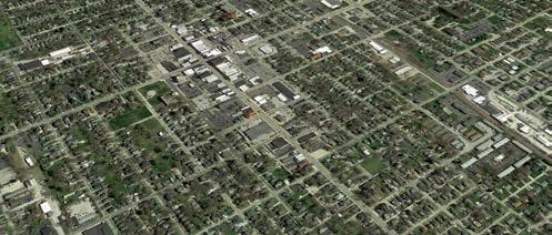
Figure 14: The Pedestrian-Residential District is one contiguous area and may include the residential area that surrounds the Central Business District, as emphasized in the image above. For the complete Zoning Map, visit https://www.bgohio. org/departments/planning-department/zoning-map.
A. Intent. The Pedestrian-Residential District promotes walkable neighborhoods with residential uses and some associated businesses. Residents in this district should be able to walk quickly, safely, and peaceably to nearby businesses. This intent is achieved through closeness between structures that encourages economical use of land and limits walking distances between neighborhood commercial spaces and adjacent residential streets
B. Lot, Building, and Design Standards. Lot, building, and any applicable design standards are set forth in the following table.
C. Uses and Use Standards. Land in this district may be used only for permitted and conditionally permitted land uses. Uses and use standards are set forth in Article III.
Lot Width
Lot Depth
40 ft. min.
100 ft. min.
Front Yard Setback20 ft. min.*
Side Yard Setback5 ft. min.
Rear Yard Setback20 ft. min.
Structure Height35 ft. max.
Lot Coverage 70% max.
Permitted Sign TypesSee Section 150.82 for sign standards.
Balcony LocationAllowed only in front and rear elevations.
Table 11: Regulatory standards for lots and structures in the PR District.
Asterisk (*) means that, when 50% or more of the frontage on one side of the street between two intersecting streets is improved with buildings that have front yards of greater or less depth than the required front yard in the PR District, no building shall project beyond the average front yard so established. However, a front yard depth shall not be required to exceed 50% in excess of the front yard otherwise required in the PR District.
University-Oriented Residential District
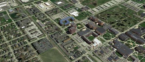
Figure 15: The University-Oriented Residential District is one contiguous area and may include the residential area adjacent to Bowling Green State University. For the complete Zoning Map, visit https://www.bgohio.org/departments/planningdepartment/zoning-map.
A. Intent. The University-Oriented Residential District promotes a mix of residential and commercial uses within walking distance of Bowling Green State University.
B. Lot, Building, and Design Standards. Lot, building, and any applicable design standards are set forth in the following table.
C. Uses and Use Standards. Land in this district may be used only for permitted and conditionally permitted land uses. Uses and use standards are set forth in Article III.
Lot Width
Lot Depth
30 ft. min.
100 ft. min.
Front Yard Setback20 ft. min.*
Side Yard Setback5 ft. min.
Rear Yard Setback20 ft. min.
Structure Height45 ft. max.
Lot Coverage 60% max.
Permitted Sign TypesSee Section 150.82 for sign standards.
Balcony LocationAllowed only in front and rear elevations.
Table 12: Regulatory standards for lots and structures in the UR District.
Asterisk (*) means that, when 50% or more of the frontage on one side of the street between two intersecting streets is improved with buildings that have front yards of greater or less depth than the required front yard in the UR District, no building shall project beyond the average front yard so established. However, a front yard depth shall not be required to exceed 50% in excess of the front yard otherwise required in the UR District.
Interstate Commerce District
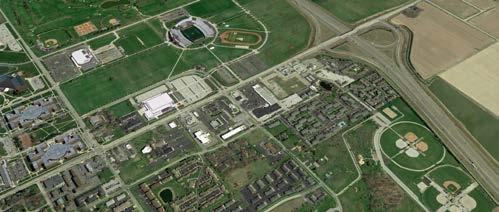
Figure 16: The Interstate Commerce District is one contiguous area and may include the automobile-focused commercial area adjacent to I-75, as emphasized in the image above. For the complete Zoning Map, visit https://www.bgohio.org/ departments/planning-department/zoning-map.
A. Intent. The Interstate Commerce District intends for a mix of lodging, commercial, and retail establishments.
B. Lot, Building, and Design Standards. Lot, building, and any applicable design standards are set forth in the following table.
C. Uses and Use Standards. Land in this district may be used only for permitted and conditionally permitted land uses. Permitted uses and use standards are set forth in Article III.
Lot Width 60 ft. min.
Front Yard Setback25 ft. min.; 60 ft. max.
Side Yard Setback0 ft. min. if not abutting a residential zone or district; 20 ft. min. if abutting a residential zone or district; 40 ft. max. for all lots
Rear Yard Setback30 ft. min.
Structure Height60 ft. max.
Lot Coverage 60% max.
Permitted Sign TypesSee Section 150.82 for sign standards.
Balcony LocationAllowed only on rear elevations and exposed side elevations.
Table 13: Regulatory standards for lots and structures in the IC District.
Central Business District
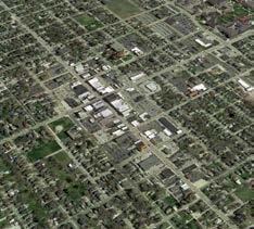
Figure 17: The Central Business District is one contiguous area and includes the historic downtown area emphasized in the image above. For the complete Zoning Map, visit https://www.bgohio.org/departments/ planning-department/zoning-map.
A. Intent. The Central Business District promotes the vitality of Bowling Green’s historic downtown with buildings close to the street, shopfronts with transparent facades, and a broad mix of uses.
B. Lot, Building, and Design Standards. Lot, building, and any applicable design standards are set forth in the following tables. The standards in Table 15 shall apply to any new development or an expansion of an existing building by more than 20% of GFA.
C. Uses and Use Standards. Land in this district may be used only for permitted and conditionally permitted land uses. Uses and use standards are set forth in Article III.
Front Yard Setback10 ft. max. for structures with no front patio; 15 ft. max. for structures with a front patio
Side Yard Setback0 ft. min.
Rear Yard Setback0 ft. min. and 30 ft. max. if rear yard does not abut a residential zone or district; 30 ft. min. and no max. if rear yard abuts a residential zone or district.
Structure Height35 ft. min.
Commercial Ground Floor Area 100% of building’s ground floor area min.
Permitted Sign TypesSee Section 150.82 for sign standards.
Balcony LocationAllowed only on rear elevations and exposed side elevations.
Table 14: Regulatory standards for lots and structures in the CB District.
Building Massing
Primary Façades
Buildings should be taller than they are wide and should appear as a row of buildings.
70% of street frontage must be devoted to front façade. No service drive curb cuts are allowed within the building street wall frontage. Building entrances shall be at the front façades and articulated as significant public entrances and may be emphasized with canopies or similar features to provide a minimum clearance of 9 ft. above the sidewalk.
Retail Floor to Floor Heights16 ft. min.
Building Corners
Building Rooflines
Building Transparency/ Fenestration
Storefronts
Gutters
Lighting
Building Equipment
Building corner height may be increased by up to 10 feet to articulate key architectural corners.
Predominant roof form shall be flat and parapeted. Vertically projecting elements or elevated sloped roof forms are allowed at prominent building corners. Roofs shall be considered a visible elevation and shall be designed with features, materials and patterns that reflect the character of the building.
The maximum length of any segment of a street-fronting ground-floor façade without transparency is 20 ft. Building fenestration at floors above street level shall include a minimum of 40% openings or windows. While punched windows are encouraged, substantially increased openings or all-glass walls are allowed in recessed or special corner feature areas. Reflective or dark tinted glass is prohibited. Street level storefronts shall have transparent glass.
Storefronts shall be provided for no less than 75% of the length of streetfronting ground floor front façades. Storefront sills shall be no higher than 3 ft. above the adjacent sidewalk and tops of storefront openings shall be no less than 10 ft. above the adjacent sidewalk. All ground-level retail shall have its own entrance opening directly to a street. Storefronts shall continue at the exposed side of buildings for no less than 40 ft. from the front façade.
Flat roofs should drain to internal roof drains and/or to the rear, leaving streetfronting façades free of gutters and downspouts. Roofs may be occupiable and embellished for amenity use. Stair and elevator access to roof shall be integrated into the core architecture.
Lighting shall be aimed downward at the building such that no light projects above the fixture.
No mechanical or utility equipment may be located within 20 ft. of the streetfronting façade or corner. No mechanical systems shall be visible from any street. Unit exhaust and louvers are not allowed on façades - systems shall route through roof.
Table 15: Building Design Standards for the Central Business District Table. These building standards shall apply to any new development or an expansion of an existing building by more than 20% of GFA.
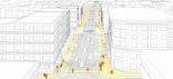
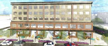
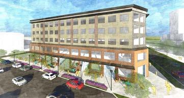
Bowling Green Gateway District
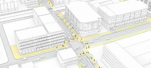
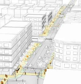
18: Illustrative view of desired development pattern looking west along E. Wooster Street at the intersection of Manville Avenue / Thurstin Street
A. Intent
(1) The Bowling Green Gateway District (“BG Gateway District”) is established to promote the development of a higher intensity, urban neighborhood center along E. Wooster Street between Manville Avenue/Thurstin Street and Enterprise Street serving as a gateway and vibrant connection between Bowling Green State University and Downtown Bowling Green. The BG Gateway District respects existing surrounding development patterns while promoting the desired development patterns along this important gateway.
(2) The following are the desired characteristics of the BG Gateway District:
(a) A mixture of storefront retail, professional offices, and dwelling units located in townhouses, apartment buildings, and in the upper stories or rear of mixed-use buildings;
(b) Buildings with active building façades set at or close to the sidewalk; and
(c) Pedestrian-oriented scale with sidewalks wide enough for activation, and regularly-spaced street trees that promote a walkable environment.
B. Applicability
This Section contains the use regulations for all property and development standards for new construction within the BG Gateway District.
C. Major Development Site
(1) The BG Gateway District includes an approximately four-acre major development site at the corner of Manville Avenue/Thurstin Street and E. Wooster Street, which is referred to as the “Major Development Site”. The Major Development Site forms the entrance gateway to the East Wooster mixed-use corridor and extends north along Thurstin Street to East Court Street, which is also well-traveled by students and the daytime worker population.
(2) This chapter contains specific use and development regulations applicable to the Major Development Site. Except as otherwise set forth herein, all regulations of the Zoning Code shall apply to the Bowling Green Gateway District, and, where any regulations conflict, the provisions of this Article II shall govern and control.
(3) Buildings and structures containing only one use are not permitted in the Major Development Site.
(4) Parking within the Major Development Site shall take place in parking structures only, provided, however, that up to 10% of the total parking area may be located on surface parking areas in the rear yard area.
D. Permitted Uses
(1) Land in this district may be used only for permitted and conditionally permitted land uses. Uses and use standards are set forth in Article III.
(2) Some uses may be permitted on the first floor of a structure in the Bowling Green Gateway District but may not be permitted on upper floors. Some other uses may not be permitted on the first floor of a structure in the Bowling Green Gateway District but may be permitted on upper
Street Level / First Floor Uses Upper Floor Uses
floors.
E. Lot and Site Standards
All uses, lots, and structures in the Bowling Green Gateway District must comply with the lot and site standards set forth in the following pages.
F. Massing and Facade
All uses, lots, and structures in the Bowling Green Gateway District must comply with the massing and facade standards set forth later in this section.
G. Building Design Elements
All uses, lots, and structures in the Bowling Green Gateway District must comply with the building design elements set forth later in this section.
Adjacent Lot
20: Regulatory graphic illustrating lot standards BOWLING GREEN GATEWAY DISTRICT
Right-of-Way
Lot Dimensions
Project Area (Min. Acres) N/A
Lot Size (Min.) N/A
Lot Size (Max.) N/A
Lot Width (Min. Ft.) - For New Lots 120
Lot Width (Max. Ft.) N/A
Front Yard Setback (Min. Ft.)0
Front Yard Setback (Max. Ft.)0*
Primary Structure Buildable Area
Adjacent Lot
Gateway
Front yard setback is 0’ (up to 5’ to undulate façade, up to 15’ if patio is located at front of building as stated below).
*Front yard setbacks may vary by up to 5 feet to undulate the façade to provide variety and interest. Maximum front yard setbacks can be increased to 15 feet if outdoor patio included for front yard activities such as outdoor dining.
Side Yard Setback (Min. Aggregate. Ft.)
Side Yard Setback (Max. Aggregate Ft.)
Rear Yard Setback (Max. Ft.)30 max. if not abutting a residential zone or district; 20 min. if abutting a residential zone or district
Table 16: Regulatory standards for lots and structures in the Bowling Green Gateway District.
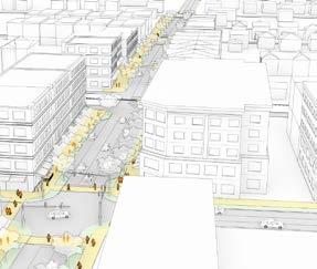
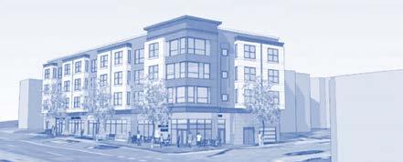
Figure 21: Illustrative view of building placement and desired development pattern looking west down E. Wooster Street at the intersection of Manville / Wooster / Thurstin Streets
Min. # Residential Units per Acre 12; Major Development Site, 20.
Lot Coverage (Min.)Excluding paved areas 80%
Parking Location
Minimum Lot Coverage 80% A
Primary Structure
Figure 22: Regulatory graphic illustrating lot coverage.
Structured parking within or below building; surface parking permitted in rear yard only and must be landscaped. Major Development Site shall have structured parking only; provided however, up to 10% of total parking may be located on surface parking areas in the rear of buildings.
Open Space (Min.) - Paved areas not included N/A
Buffering
Where a property abuts an ‘R’ zone (R-1, R-2, R-3), a 5’ foot buffer yard must be provided along the lot line(s) shared with adjacent ‘R’ zone property. The buffer yard must be planted with shrubs or ornamental trees that will reach a height of at least 6 feet at maturity, with plant spacing at the minimum recommended plant spacing for the particular plant genus.
Table 17: Lot and site standards in the Bowling Green Gateway District.
Building MassingBuildings should be taller than they are wide and should appear as a row of buildings. A strong unifying horizontal expression over the ground level retail area.
Primary Façades70% of street frontage must be devoted to front façade. No service drive curb cuts are allowed within the building street wall frontage. Building entrances shall be at the front façades and articulated as significant public entrances and may be emphasized with canopies or similar features to provide a minimum clearance of 9 feet above the sidewalk. The maximum length of any segment of a street-fronting ground floor façade without transparency is 20 feet.

Railings and Decorative Elements Iron, metal, or powder-coated aluminum
Retail Floor to Floor Heights (Min. Ft.)
Building Corners

Building Rooflines
16
Building massing should step back at the corners at intersections and building corner height may be increased by up to 10 feet to articulate and celebrate these key gateway corners. At building corners and façade segments at spaces between buildings, change of materials, projections and delineating features and additional height are allowed and encouraged.
Predominant roof form shall be flat and parapeted. Vertically projecting elements or elevated sloped roof forms are allowed at prominent building corners. Roofs shall be considered a visible elevation and shall be designed with features, materials and patterns that reflect the character of the building.
25:
Building Transparency/ Fenestration
Storefronts
Balconies
Gutters
Lighting
Building fenestration at floors above street level shall include a minimum of 40% openings or windows. While punched windows are encouraged, substantially increased openings or all-glass walls are allowed in recessed or special corner feature areas. Reflective or dark tinted glass is prohibited. Street level storefronts shall have transparent glass.
Storefronts shall be provided for no less than 75% of the length of streetfronting ground floor front façades.
Storefront sills shall be no higher than 3 feet above the adjacent sidewalk and tops of storefront openings shall be no less than 10 feet above the adjacent sidewalk.
All ground level retail shall have its own entrance opening directly to a street. Storefronts shall continue at the exposed side of buildings for no less than 40 feet from the front façade.
None allowed facing E. Wooster Street or Thurstin Avenue
Flat roofs should drain to internal roof drains and/or to the rear leaving street-fronting façades free of gutters and downspouts. Roofs may be occupiable and embellished for amenity use. Stair and elevator access to roof shall be integrated into the core architecture.
Lighting shall be aimed downward at the building such that no light projects above the fixture. Building lighting should be mounted at 8 feet or higher.
Table 19 (Continued): Design standards in the Bowling Green Gateway District.
Building Equipment No mechanical or utility equipment may be located within 20 feet of the street-fronting façade or corner. No mechanical systems shall be visible from any street. Unit exhaust and louvers are not allowed on façadessystems shall route through roof.
Table 19 (Continued): Design standards in the Bowling Green Gateway District.
Table 20: Building and lot standards by district or zone. A hyphen (-) indicates that no standard has been established.
An asterisk (*) indicates that a one-unit dwelling may be erected on a lot that is at least 40 feet wide and is of official record as of the effective date of this chapter (an “existing lot of record”), irrespective of the area of the lot, provided the owner of such lot does not own any adjoining property, and provided that the other required zone standards are met.
AWhen abutting a lot that permits dwelling units by right, the setback shall be 50 ft. min.
BSide yard setback must be maintained on one side of the lot only. All other side yards may have a zero-foot setback.
C20 ft. min. when not abutting dwelling use or residential zone or district; at least one foot for every one foot of building height or 20 ft., whichever is greater, when abutting a dwelling use or residential zone or district.
D0 ft. min. if not adjacent to a residential use; 10 ft. min. if adjacent to a residential use.
E80 ft. max., except that structures may exceed 80 ft. of height if they provide an extra 0.5 ft. of side and rear yard setback for each 1 ft. of height exceeding 80 ft.
Table 20 (Continued): Building and lot standards by district or zone.
A hyphen (-) indicates that no standard has been established.
EWhen 50% or more of the frontage on one side of the street between two intersecting streets is improved with buildings that have front yards of greater or less depth than the required front yard in the district, no building shall project beyond the average front yard so established. However, a front yard depth shall not be required to exceed 50% in excess of the front yard otherwise required in the district.
FFront yard setbacks may vary by up to 5 feet to undulate the façade to provide variety and interest. Maximum setback can be expanded in depth to 15 feet if an outdoor patio is included for outside activity, such as dining.
GApplies only if the yard does not abut a residential zone or district.
HApplies only if the yard abuts a residential zone or district.
IFor the Bowling Green Gateway District, specifically, lot coverage does not include paved surfaces.
JHowever, Major Development Sites require a minimum residential density of 20 units per acre.
This article sets forth the permitted and conditionally permitted principal and accessory uses for all zones and districts.
The Planning Director shall have the right to determine whether a use not listed herein is similar to a listed use and either permitted or conditionally permitted herein. In determining whether a use is similar, the Planning Director shall find that, in their professional opinion, the use:
A. Is similar in definition or purpose to a listed use;
B. Is expected to demand equal or lesser levels of government services, such as police, fire, water, sewer, and other infrastructure services than the similar listed use;
C. Is expected to have a equal or lesser negative impacts on public health, safety, and environmental quality than the similar listed use; and
D. Is expected to cause equal or lesser transmission of noise, light, vibration, and air pollutants to neighboring properties than the similar listed use.
The comprehensive use table included in this article describes which uses are permitted and conditionally permitted in each zone and district. Any use not expressly permitted or conditionally permitted herein and not determined by the
Planning Director to be similar to a listed use, in accordance with Section 150.41, shall be prohibited.
Table 21:Uses permitted in each district or zone.
P = Permitted principal use. Review later sections of this article for use-specific standards.
C = Conditional principal use. Conditional uses must be approved according to processes outlined in Section 150.98. Review later sections of this article for use-specific standards.
PA = Permitted accessory use. Review later sections of this article for use-specific standards.
Table 21: Uses permitted in each district or zone.
P = Permitted principal use. Review later sections of this article for use-specific standards.
C = Conditional principal use. Conditional uses must be approved according to processes outlined in Section 150.99. Review later sections of this article for use-specific standards.
PA = Permitted accessory use. Review later sections of this article for use-specific standards.
Primary or Secondary
Table 21: Uses permitted in each district or zone.
P = Permitted principal use. Review later sections of this article for use-specific standards.
C = Conditional principal use. Conditional uses must be approved according to processes outlined in Section 150.99. Review later sections of this article for use-specific standards.
PA = Permitted accessory use. Review later sections of this article for use-specific standards.
Those uses listed herein are specially regulated due to their unique nature and potential for impacts on surrounding uses. If a use is not listed in this section, no use-specific regulations apply; however, all uses must comply with the Generally Applicable Standards in Article IV.
A. Accessory uses must be secondary to and customarily associated with a principal use of the lot.
B. Accessory uses are permitted in any zone or district unless otherwise specified.
C. A zoning permit is required for any accessory use that occupies an accessory structure of more than 100 square feet.
D. An accessory use and any accessory structure in which it is conducted must be located on the same lot as the principal use with which it is associated unless a variance is granted by the Zoning Board of Appeals.
E. Accessory uses and their structures include, but are not limited to:
(1) Accessory dwelling units
(2) Car ports
(3) Decks
(4) Garages
(5) Gazebos
(6) Outdoor entertainment
(7) Patios
(8) Pergolas or trellises
(9) Rain gardens
(10) Sheds
(11) Solar panels and wind turbines
(12) Swimming pools, hot tubs, recreational ponds, and retention ponds
(13) Swing sets or play houses
(14) Tennis or other sport areas
(15) Outdoor storage
(16) Tree houses
(17) Radio or television antenna towers
F. Required Setbacks for Accessory Uses
(1) An acce ssory use must meet the setbacks as described in the accessory use setback table on the following page.
(2) Other setb ack requirements are as follows:
(a) The top of the bank of a retention pond must maintain a front yard setback of at least 10 feet, a side yard setback of at least 10 feet, and a rear yard setback of at least 10 feet.
(b) Fences and gardens are not required to comply with minimum setback requirements.
(c) Hot tubs are not required to comply with minimum setback requirements for accessory structures.
(d) Patios are not required to comply with minimum setback requirements for accessory structures. Patios are required to be located a minimum of three (3) feet from all lot lines, but cannot be located in a utility easement.
G. Swimming Pool, Hot Tub, Recreational Pond, and Retention Pond Fences
(1) In-ground s wimming pools and recreational ponds shall be enclosed with a solid fence at least four (4) feet high with a self-closing gate.
(2) Hot tubs shall be enclosed with a locking lid or cover or enclosed with a solid fence at least four (4) feet high with a selfclosing gate.
(3) In any district, a retention pond does not require a fence.
H. The outdoor display of commercial equipment, materials, or products for sale or rent is prohibited, unless the outdoor display is set back from the front lot
Accessory use type: Is the accessory use functionally attached to a principal structure? Is the accessory use 100 square feet or less?
Swimming Pool or Recreational Pond
Other Accessory Use
Table 22: Accessory use setback table.
line(s) a distance equal to the minimum front yard setback required for that zone or district. Any sign that is part of an outdoor display shall comply with the sign standards of this Zoning Code.
I. Outdoor entertainment is an accessory use of a commercial principal use.
J. Specific Use Regulations for Accessory Dwelling Units
(1) Definition. An accessory dwelling unit is a dwelling unit that facilitates a dwelling use customarily associated with and secondary to a principal use of a lot. If a lot contains a principal dwelling and an accessory dwelling, and if such accessory dwelling is detached from the principal dwelling, the accessory dwelling shall be the dwelling with the greater setback from the front lot line.
(2) Purpose. This Zoning Code permits the development of accessory dwelling units with the intent to increase the supply of housing units, allow property owners to increase the economic productivity of their land, provide housing diversity that may be more financially accessible to small households, and serve as accessible housing for older adults and people with disabilities.
(3) Eligibility. An accessory dwelling unit may be erected in a zone or district that permits accessory dwelling units and may be erected on any lot that conforms to applicable lot standards.
(4) Creation. An accessory dwelling unit may be created through new construction, the conversion of an existing structure, as an addition to an existing structure, or as a conversion of a qualifying existing house during the construction of a new principal dwelling unit on the site.
(5) Quantit y. No lot may contain more than one accessory dwelling unit.
(6) Occupancy and Use.
(a) An accessory dwelling unit must conform to all building code and
health code standards applicable to all dwellings.
(b) On any lot with an accessory dwelling unit, one of the dwelling units, either the principal dwelling unit or the accessory dwelling unit, must be occupied at least 180 days per calendar year by the owner of the lot or structure, or, in the case that the lot or structure has multiple owners or is owned by a corporation, one of the dwelling units must be occupied at least 180 days per calendar year by one of the those owners or by one of the members of the corporation in ownership.
(c) Occupancy of an accessory dwelling unit shall be limited by Section 150.59.
(7) Size and Height
(a) No accessory dwelling unit may exceed 1,200 square feet of GFA.
(b) If an accessory dwelling unit is detached from the principal structure, it shall not exceed 25 feet in height.
(c) If an accessory dwelling unit is detached from the principal structure, it shall be located in the rear yard.
(8) Screening. If an accessory dwelling unit is detached from the principal structure and includes living space on the ground floor, the rear yard of the lot shall be screened with six-foot-high opaque fencing where abutting any lot in a residential zone or district.
(9) Parking. Any off-street parking area must comply with parking area location requirements in Section 150.72.A.
(10) Setbacks of Accessory Dwelling Units
(a) If an accessory dwelling unit is attached to a principal dwelling unit, it shall maintain setbacks applicable to principal structures in the zone or district in which it is located. If the principal structure is nonconforming with applicable setbacks, an accessory
dwelling unit may be attached to the principal structure if its creation does not increase the degree of nonconformity.
See Article V.
(b) If an accessory dwelling unit is detached from a principal structure on the lot, it shall maintain setbacks as described in the Accessory Use Setback Table for non-garage accessory structures. If an accessory dwelling unit is constructed within or above a detached garage or as a replacement of a structure formerly intended for use as a garage, it shall maintain setbacks as described in the Accessory Use Setback Table for garages.
(c) Building Coverage. Accessory dwelling unit coverage shall be considered when calculating lot coverage.
A. Purpose for Regulation of Sexually Oriented Business.
(1) Additional regulations are imposed upon sexually-oriented businesses to: protect juveniles from harm or exposure to sexually-oriented materials; prevent the spread of communicable or sexually transmitted diseases; reduce and eliminate the negative impact that adult uses may have on property values and the character and quality of residential neighborhoods; prevent sexually-oriented businesses from diminishing or destroying the use of public facilities, particularly facilities expected to be used by children or used for religious purposes, and the like. These regulations are not adopted for the purpose of restricting or prohibiting any protected speech associated with sexually oriented business land uses. The Supreme Court and lower federal courts have recognized a number of possible secondary effects of sexually oriented businesses, including:
(a) Decline of character of a community’s neighborhoods and quality of life;
(b) Increase of crime (e.g., prostitution, drug sales);
(c) Spread of disease, particularly sexually transmitted diseases;
(d) Degeneration of the social and moral order; and
(e) Harm to children.
B. Given the documented harmful secondary effects of sexually oriented businesses on adjacent neighborhoods and specific land uses, the following specific, reasonable and uniform regulations have been developed to protect the public health and safety of the residents of the city.
C. A sexually oriented business use may not be an accessory use. No two sexually oriented businesses uses may be located in the same premises or on the same lot.
D. The following establishments or accessory uses of an establishment shall be prohibited within the city:
(1) Nude model studios;
(2) Sexual encounter centers;
(3) Sexually oriented escort agencies;
(4) Sexually oriented spas; or
(5) Sex ually oriented viewing booth or arcade booth facilities, each more specifically defined by this regulation.
E. The following are prohibited activities in a sexually oriented business establishment:
(1) No emplo yee, patron, or any other person at a sexually oriented business establishment shall perform or conduct any specified sexual activity with or for any other employee, patron, or any other person on the premises;
(2) No sex ually oriented business establishment games, machines, tables, or implements shall be used for gambling;
(3) No sex ually oriented business establishment employee or other person shall accept any form of a tip or gratuity offered directly or personally by a patron or other person for entertainment performances. Any such tips or gratuities must be placed into a receptacle provided by management for receipt of such tips and gratuities or shall be placed on the stage on which the employee or other person is performing.
(4) No sex ually oriented materials, or displays, promotions, or advertisement which display specified sexual anatomical areas or specified sexual activities, shall be displayed, distributed, or exhibited so as to be visible from the public right-of-way, or from any adjacent public or privately owned property, or by juveniles permitted within the establishment.
(5) All building openings, entries, windows, and doors of sexually oriented businesses shall be located, covered, or serviced in such a manner as to prevent a view into the interior from the public right-of-way, or from adjacent public or privately owned property. For new construction, the building shall be oriented so as to minimize any possibility of viewing from any public right-of-way or any public or private property.
(6) No screens, loudspeakers, or sound equipment used in sexually oriented motion picture theaters (enclosed or drive-in) or other sexually oriented businesses shall be operated in such a manner as to be seen or discerned from the public right-of-way or any public or privately owned property.
F. No animals, except service animals required to assist those that are differently abled, shall be permitted at any time or in any sexually oriented business establishment.
G. All restrooms in a sexually oriented business establishment shall be equipped
with standard toilets, sinks, and other customary lavatory facilities. No sexually oriented materials or live performances shall be provided or allowed at any time in the restrooms of a sexually oriented business establishment. Separate male and female restrooms shall be provided for and used by sexually oriented business establishment employees and patrons.
H. No person shall engage in a live performance of sexually oriented material except upon a stage elevated at least 18 inches above floor level.
I. All parts of the stage, or a clearly designated area thereof within which a person engages in a live performance of sexually oriented material, shall be a distance of at least six (6) feet from all parts of a clearly designated area in which patrons may be present.
J. The stage or designated area thereof shall be separated from the area in which patrons may be located by a barrier or railing the top of which is at least three (3) feet above floor level.
K. No person engaging in such live performances or patron may extend any part of their body over or beyond the barrier or railing. This requirement shall be noted in a sign affixed to the stage, barrier, or railing in such a manner to be easily visible and legible to patrons.
(1) No person under the age of 18 years shall be admitted to or employed by a sexually oriented cabaret or theatre;
(2) No person under the age of 18 years shall be allowed or permitted to purchase or receive, whether for consideration or not, any sexually oriented material or other goods or services at or from any sexuallyoriented business establishment; and
(3) No person under the age of 21 years shall be permitted to a sexually oriented business establishment that serves or otherwise provides alcoholic liquor and
pursuant to a liquor license.
M. Sexually oriented uses shall not be located in any of the following locations:
(1) Within 1,000 feet of any land zoned or used for primarily residential purposes (specifically the R-1, R-2, and R-3 Zones and the PR and UR Districts), libraries, educational institutions, training facilities for persons with mental or physical disabilities, museums, religious places of worship, child day care facilities, parks, playgrounds, swimming pools, pool and billiard halls, video arcades, pinball arcades, or other public gathering places, family-oriented uses, or recreational uses established for the activities of juveniles; and
(2) Within 1,000 feet of any other sexually oriented business, or within 1,000 feet of any bar, tavern, or other establishment regulated by the Ohio Division of Liquor Control offering the sale of beer or intoxicating liquor for consumption on the premises in combination with live entertainment.
(3) For the purpo se of this section, measurement shall be made in a straight line without regard to the intervening structures or objects, from the nearest point of the property line of a sexually oriented business, to the nearest property line of the protected district or premise listed above. The presence of a municipal, county, or other political subdivision boundary shall be irrelevant for the purpose of calculating and applying the distance requirements of this section.
N. Exterior identification signage of sexually oriented businesses is permitted subject to the other applicable provisions of these regulations. However, no exterior signage shall include verbal or written messages, graphics, drawings, or other illustrations which publicly display specified sexual anatomical areas or specified sexual activities.
O. The City shall reserve the right to review
facilities established under this section after it has been in operation for a period of one year.
A. Airports located partly within and partly outside of the city limits shall be subject to county airport zoning. Airports located entirely within the corporate limits shall be subject to this section.
B. A site plan is required prior to the granting of a zoning permit. The required site plan shall show the location of all landing strips, runways, taxiways, and aircraft parking areas; all buildings, hangars, and terminals; all drives and parking areas and screening and planting; and all clear zones and transition zones.
C. The Planning Director shall not grant a permit for the construction or operation of an airport or landing field until they have received evidence that the proposed traffic patterns will not conflict with traffic patterns of existing airports or interfere with FAA-approved instrument landing procedures.
D. The Planning Director shall ensure that adequate ingress and egress, parking, and protection of adjacent property is provided.
Outside runs or kennels must be more than 200 feet from any dwelling.
A. A site plan is required prior to the issuance of a zoning permit. The required site plan drawing shall include the location of buildings, drives, pumps, underground storage tanks, signs, and screening or fences.
B. No pump dispensing gasoline, diesel,
kerosene, natural gas, propane or other hydrocarbon shall be located within 100 feet of any lot occupied by a dwelling. A boundary buffer as described in Section 150.80 shall be provided on all lot lines adjacent to a lot occupied by a dwelling.
C. A side yard setback of at least 20 feet shall be maintained.
D. No permanent storage of inoperable vehicles shall be permitted on the site. Inoperable vehicles are defined in the City of Bowling Green Code of Ordinances Section 70.40.
E. A traffic impact study shall be prepared and reviewed in accordance with the City’s Access Management Policies and Guideline for purposes of determining access prior to the issuance of a zoning permit.
A. An eight-foot-high, 100%-opaque fence shall be required to screen all activities on the property.
B. No open burning, cutting, or processing is permitted.
A. A bed and breakfast inn use must be subordinate to a principal use. The principal use must be a dwelling. The dwelling must be the primary residence of the property owner or proprietor.
B. A live, evergreen vegetated screen shall be six feet tall at minimum and shall screen any off-street parking spaces from all adjoining properties.
C. No rented bedroom shall have an independent outside entrance, except where an emergency exit is provided and such exit is only capable of opening from the inside.
D. A maximum of five rented bedrooms are
permitted, and all such rooms shall be located in the principal structure.
E. Rented bedrooms may only be used by transient visitors and travelers and rented on a nightly, weekend, or weekly basis. No person, other than the principal resident and their family, may stay in the bed and breakfast inn for a period exceeding 120 consecutive days in a calendar year.
F. All applications for bed and breakfast inn use will be reviewed by the Fire Chief or their designee to ensure that all appropriate safety regulations are met.
A. The site occupied by any cemetery shall be at least 10 acres in area.
B. A site plan shall be required prior to the issuance of a zoning permit. The site plan shall show the location of all drives, structures, and parking so that the Planning Director shall ensure that adequate ingress, egress, and parking are provided.
A. A corner store use shall not be permitted on any lot unless such lot is a corner lot.
B. A corner store use shall not be conducted within any portion of a structure unless the corner store use is conducted fully within the basement or first floor of the structure.
C. The portion of a structure used or intended to be used as a corner store and its ancillary uses may not exceed 1,000 sq. ft.
D. A corner store use is limited to the following commercial uses. Such commercial use is permitted in a corner store even if the specific use is not listed as permitted or conditionally permitted in the zone or district at issue.
(1) Fo od or beverage sales for on-
premises consumption
(2) Foo d or beverage sales for offpremises consumption
(3) Retail
(4) Artisan manufacturing
(5) Household services, such as, but not limited to, launderer, tailor, cobbler, pet groomer, salon or spa, barber, child day care provider, and repair service.
E. The Planning Director, at their discretion, may allow additional commercial uses upon application.
A. An 80%-opaque fence of at least four feet of height shall be installed to screen adjacent uses from view of the play areas, provided, however, that no such fencing shall be installed within any front yard setback.
B. A screen of live, evergreen plantings shall be installed immediately outside of and adjacent to the required screen fence. An earthen mound of at least four (4) feet of height may be substituted for the evergreen plantings, but the required solid fence shall not be placed on any portion of the mound.
C. An enclosed recreation area, open or partially under roof, containing a minimum of 50 square feet per dayresident, shall be provided.
D. Any entry drive shall follow the City’s Access Management Policies and Guidelines.
E. A site plan is required prior to the issuance of a zoning permit. The required site plan shall show all drives, parking areas, building locations, recreation areas, and screening and plantings.
F. The Planning Director shall ensure that adequate ingress, egress, parking, and protection of adjacent property are provided.
A. A delivery distribution center shall not exceed 5,000 square feet per lot.
B. A delivery distribution center within 200 feet of a dwelling use shall not operate between the hours of 10:00pm and 7:00am.
A. A home occupation must be accessory to the principal use of the lot as a dwelling.
B. If a home occupation occupies a structure other than the principal structure on the lot, it must occupy a structure otherwise customarily associated with a principal dwelling, such as a garage or shed.
C. No display or indication shall be allowed that would indicate from the exterior of the structure or the land that any uses are being made of such structure or land other than that of a dwelling with the exception that one (1) commercial sign not exceeding one (1) square foot in sign area may be affixed to the exterior of the structure.
D. A home occupation shall not cause significant increases in traffic volumes on the street fronted by the home occupation by persons other than the persons occupying the home. For this regulation, a significant increase in traffic volume is defined as a 50% increase in vehicle trips in any 4-hour period.
E. A home occupation may not serve inperson customers between the hours of 10:00 PM and 6:00 AM.
A. The use may include an accessory retail shop for the sale of related equipment.
B. Any reconstruction of an existing
structure necessary to accommodate the indoor sports training facility use shall not permanently alter the structure so that it cannot be reused for industrial, office, or business purposes.
C. The applicant must submit a report as part of the zoning permit application from an architect, engineer, or contractor indicating the building is suitable for use as an indoor sports training facility and any building modifications required would not preclude the structure’s reuse for industrial, office, or business purposes.
D. Buildings and uses are subject to City inspections for zoning compliance.
A. A mobile home park shall constitute five acres unless the development is an extension of an existing mobile home park.
B. The mobile home park must have a minimum frontage, measured at the right-of-way line, on a major street of at least 200 feet.
C. All interior drives and parking areas shall be asphalt or concrete and the drive approach to the public street must be a minimum of 26 feet wide, with straight curb and gutter.
D. A sidewalk, built to the City Engineer’s specifications and at least five feet in width, shall be constructed alongside the public street within the right-of-way.
E. The utility plan, including storm drainage, shall meet the approval of the City Engineer.
F. The Access Management Committee, under the authority of the Access Management Policies and Guidelines, shall approve ingress and egress.
G. The Fire Chief shall approve the locations and types of fire hydrant, and all interior drives shall be designed to accommodate the City’s fire trucks.
A. The minimum lot area shall be 24,000 square feet, except in the CB, IC, C, PR, and UR Districts, where the minimum lot area shall be 12,000 square feet and where the principal structure may contain one accessory dwelling unit for the exclusive use of the mortuary’s on-call employee(s).
B. A site plan is required prior to the issuance of a zoning permit. The required site plan shall show the location of all structures, drives, parking, screening or screened planting, and the interior location and size of any parlors or service rooms.
C. A screening fence of at least four feet in height shall be provided for any parking area adjacent to any property occupied by a dwelling.
D. No more than one sign shall be permitted. The sign may not be illuminated and may not exceed 24 square feet in sign area.
E. The Access Management Committee, under the authority of the Access Management Policies and Guidelines, shall approve ingress and egress.
A. The minimum lot area shall be 12,000 square feet for the first 10 beds, plus 1,000 square feet for the first 10 occupants, plus 1,000 square feet per additional occupant.
B. An enclosed recreation area, open or partially under roof, containing a minimum of 50 square feet per bed, shall be provided.
C. There shall be a minimum of 60 feet of frontage on a major street, and the frontage shall contain at least one entry drive to the site.
D. The Access Management Committee,
under the authority of the Access Management Policies and Guidelines, shall approve ingress and egress.
150.60 ONE-UNIT DWELLING,
DWELLING,
DWELLING
A. Within each dwelling unit in a oneunit dwelling, a two-unit dwelling, or a mulitple-dwelling unit, occupancy is limited according to the following table.
Table 23: Dwelling Maximum Occupancy Table.
B. In the Central Business District (CB), no dwelling unit of a multiple-unit dwelling may occupy any ground floor portion of a structure.
C. The Access Management Committee, under the authority of the Access Management Policies and Guidelines, shall approve ingress and egress of multiple-unit dwellings.
A. Outdoor storage shall be accessory to a principal use on the same lot or an adjacent lot.
B. Outdoor storage areas must be set back
at least the minimum required front yard setback for the zone or district in which it is located.
C. Outdoor storage areas must be screened from view of residential zones or districts and any dwelling use using six-foot-high evergreen vegetation or a six-foot-high, opaque fence.
A. A fence of at least four (4) feet of height and at least 80% opacity shall be required on all property lines adjacent to a lot occupied by a dwelling.
B. A site plan is required prior to the issuance of a zoning permit. The required plan shall show the location of all buildings, drives, parking areas, and fencing or screening.
A scrap yard or junk yard must be screened from view from the right-of-way with a fence of at least eight feet in height and an opacity of at least 80%.
A. The entry drive shall be in compliance with the City’s Access Management Policies and Guidelines.
B. Any redevelopment of an existing structure required to accommodate the use shall not permanently alter the building so that it cannot be reused for industrial, office, or business purposes.
Personal vehicles, such as boats and recreational vehicles, that are stored at a selfstorage facility must be screened from public view with an opaque fence or wall of at least six feet in height.
A. Solar panels or wind turbines shall be considered accessory uses to the principal use on the lot.
B. If a solar panel or wind turbine use is the only use of a lot, and the lot is less than one acre in area and is adjacent to a lot owned by the same landowner, the solar panel or wind turbine use shall be considered accessory to the principal use of the adjacent lot under common ownership.
C. All electric generating facilities connected to the City of Bowling Green’s electric system are subject to the requirements of the Board of Public Utilities and approval by the Utilities Executive Director.
A. The passage of the Federal Telecommunications Act of 1996 (the “Act”) has permitted and fostered the rapid growth of wireless telecommunications services and has given rise to the concomitant need for adequate telecommunications facilities, including towers and other structures.
B. Section 704(a) of the Act generally preserves the authority of local governments over decisions regarding the placement, construction, and modification of such facilities, subject to the limitations specified in the Act and incorporated in this legislation. The City of Bowling Green, by adoption of its charter on October 31, 1972 exercises its home rule authority.
C. The City of Bowling Green, in order to properly address the requirements of the Act, enacted a moratorium on permits for placement, construction, and modification of such facilities until July 15, 1998.
D. This local government has examined the escalating facility needs of wireless telecommunications providers in the context of addressing, in comprehensive fashion, concerns regarding the placement, construction, and modification of telecommunications facilities generally. In an effort to balance the needs of the telecommunications industry and the health, safety and general welfare of the public, the City of Bowling Green has closely examined the competing considerations relating to the placement, construction, and modification of telecommunications facilities.
E. The intent of this legislation is to preserve the ability of telecommunications providers to operate facilities as necessary within the jurisdiction of this local government, while at the same time:
(1) Minimizing the adv erse visual impacts of telecommunications towers, attachments, poles, nodes, and related facilities;
(2) Protecting persons and property from injury and damage; and
(3) Pre serving and protecting natural resources and formations.
F. It is not the intent of this legislation, and consistent with the provisions of the Act, nothing in this legislation shall be construed:
(1) To permit unreasonable discrimination among providers of functionally equivalent personal wireless services, as defined in the Act;
(2) To pr ohibit or have the effect of prohibiting the provision of personal wireless services;
(3) To permit action on any request for the authorization to place, construct, or modify personal wireless services facilities other than within a reasonable period of time after the request is duly filed, taking into account the nature and scope of the
(4) To permit denial of an applica tion to place, construct, or modify personal wireless services facilities other than in writing and supported with substantial evidence contained in a written record; and
(5) To permit basing regulatory decisions of this nature on the environmental effects of radio frequency emissions to the extent that personal wireless services facilities comply with the regulations of the FCC concerning such emissions. The provisions of this legislation are subject to all applicable federal and state laws, rules, regulations, and orders.
G. Telecommunications facilities must meet the following standards, regardless of location.
(1) Telecomm unications facilities must be as aesthetically compatible with their environs as technically feasible and practicable under the circumstances. Each tower is required to be camouflaged, for example, by putting it inside an artificial tree, a clock tower, a church steeple, silos or a flagpole.
(2) Existing v egetation must be preserved as much as practicable. Any security fencing or barrier related to telecommunications facilities must be surrounded by a continuous row of hardy, evergreen hedges or trees not less than ten feet high, sufficient in height to screen adequately such fencing or barrier, and located within ten feet of the fencing or barrier. Such landscaping shall be continuously maintained and promptly restored, if necessary.
(3) Lights, beacons, or strobes attached to or illuminating telecommunications facilities shall be permitted only to the extent necessary to ensure safety or to comply with applicable law or regulation, and shall be designed to minimize direct light or glare onto surrounding properties.
(4) Signage on the sit e of telecommunications facilities shall be permitted only as may be required by applicable law or regulation or as specifically required or approved by the City. “No Trespassing” signs with a telephone number of whom to contact in the event of an emergency shall be required.
(5) The t elecommunications provider is responsible for the weed and trash removal related to, and general upkeep of, its telecommunications facilities and their grounds, and for ensuring that the surfaces of such facilities are maintained in good condition, free from flaking or peeling paint and rust. Outdoor storage of equipment, supplies and vehicles related to telecommunications facilities is prohibited, except to supply emergency power to such facilities during a power outage.
(6) Subject to the requirements for setbacks set forth herein, telecommunications towers are to be the sole use on a lot and the minimum lot size shall be the minimum lot size allowable for the applicable zone or district. Where other types of telecommunications facilities, except telecommunications towers, are to be placed on a lot with an existing use, the minimum lot area shall be that which is necessary to accommodate the telecommunications facilities, any guy wires, any security fencing, any buffer plantings, and the like, in conjunction with such existing use.
(7) Wh ere telecommunications facilities are to be placed on a lot with an existing use, such facilities must be fully automated and operationally unattended, with visits only for construction, emergencies, and periodic and necessary maintenance.
(8) All equipment and devices (including but not limited to cables, wires, pipes, and conduits) that service telecommunications facilities shall be located underground or within such telecommunications facilities, if technically feasible and unless otherwise request;
required by the Ohio Basic Building Code, the National Electric Code, and/or other applicable law.
(9) Telecomm unications towers and telecommunications attachments shall be designed to be buildable up to the maximum height permitted by this legislation, and shall be constructed in such a way as to permit at least two other telecommunications providers to colocate their telecommunications facilities thereon when and if built to the maximum height permitted by this legislation.
(10) Unless o therwise specified in this legislation, the setback requirements for all telecommunications towers shall be one foot for every foot of allowable height of such telecommunications attachment when attached. Any related fencing, screening, or other barriers shall be located behind the applicable setback lines. Notwithstanding the first sentence of this division and unless otherwise specified in this legislation or permitted by the City, telecommunications towers and telecommunications attachments shall be located not less than:
(a) Fifty feet from the nearest public right-of-way; and
(b) Five hundred feet from the lot line of any school.
H. Telecommunications towers must meet the following standards, regardless of location.
(1) The height of t elecommunications towers (including antenna and approved lightning rods, if any) may not exceed 200 feet above the average grade plane of the telecommunications tower’s base.
(2) The color of telecomm unications towers shall be non-contrasting gray or that color which best camouflages them against their surroundings, unless another color is required by applicable law or regulation.
I. Telecommunications attachments must
meet the following standards, regardless of location.
(1) The height of t elecommunications attachments may not exceed the greater of 20 feet above the top of the building or 20 percent higher than the height of the building or structure to which it is attached. In either case, the telecommunications attachments may not exceed 200 feet in height.
(2) The color of telecomm unications attachments shall be that which best camouflages them against their surroundings, unless another color is required by applicable law or regulation.
J. Telecommunications equipment shelters must meet the following standards, regardless of location.
(1) The maximum siz e of a telecommunications equipment shelter shall be 350 square feet for one shelter on a given plot, and 750 total square feet if there is more than one shelter on a given plot.
(2) The maximum heigh t of a telecommunications equipment shelter shall be the maximum building height for the applicable land use district.
(3) The setb ack requirements for all telecommunications equipment shelters shall be the setback requirements for the applicable land use district. Any related fencing, screening, or other barriers shall be located behind the applicable setback lines.
(4) Wh ere telecommunications facilities are to be placed on a lot with an existing use, the service access to any telecommunications equipment shelter shall be provided by way of the circulation driveways associated with the existing use to the extent possible.
(5) Telecomm unications equipment shelters shall not be used for offices or long-term vehicle storage.
(6) If telecomm unications equipment shelters are initially constructed to accommodate only one user, space shall be reserved on-site to accommodate at least two other telecommunications equipment shelters in the event of colocation.
K. Additional appearance-related standards applicable to non-residential districts. In addition to all standards that apply independent of location, the following standards also apply to telecommunications facilities located in non-residential districts.
(1) Notwithstanding any provision of this legislation to the contrary, the minimum distance from the center of the base of any telecommunications tower (or the base of any building or structure directly beneath the vertical center line of a telecommunications attachment) to any residential district shall be 190 feet.
(2) Not withstanding any provision of this legislation to the contrary, if telecommunications towers are to be located in an agricultural area or a vacant lot, the minimum lot size shall be the minimum lot size required to meet all applicable setback requirements.
L. Additional appearance-related standards applicable to residential districts. In addition to all standards that apply independent of location, the following standards also apply to telecommunications facilities located in residential districts.
(1) Wh ere telecommunications facilities are to be placed in a residential district, they must be fully automated and unattended on a daily basis, with visits only for construction, emergencies, and periodic and necessary maintenance.
(2) Where telecommunications towers or telecommunications attachments are to be placed or constructed on property with a non-residential use within a residential land use district (including, but not limited
to, government buildings, agricultural buildings, churches, utility buildings, and hospitals), such telecommunications towers or telecommunications attachments shall be set back from all lots occupied by dwellings by at least one 100 feet.
(3) Telecomm unications equipment shelters located in a residential district must be placed underground.
M. Safety-related standards. Telecommunications facilities must meet the following standards, regardless of location.
(1) All telecomm unications facilities must comply with all applicable laws and regulations, including but not limited to the Ohio Basic Building Code and the applicable regulations promulgated by the Federal Aviation Administration and the FCC (including radio frequency electromagnetic emissions standards) and by the Ohio Department of Transportation, and their respective successors.
(2) All telecomm unications towers and telecommunications attachments must be soundly constructed and, including any guy wires, must be securely anchored to a foundation appropriate for the applicable soil conditions, and must be able to withstand sustained winds of at least eighty (80) miles per hour and ice loads in accordance with the American National Standards Institute/Electronic Industry Association, Section 222-F (Annex H: Commentary on Ice Design Criteria for Communications Structures), as the same may be amended from time to time.
(3) Security fencing eight feet in height shall surround the telecommunications facilities (including any guy wires), or each of them, as required by applicable law or as may be determined by the appropriate unit of this local government. All outside storage of related vehicles or equipment shall be contained within the fenced area.
(4) Telecomm unications towers and
telecommunications attachments shall be fitted with anti-climbing devices.
(5) All telecommunications facilities must be regularly maintained as appropriate to ensure that safety is not compromised.
(6) No telecommunications facilities may interfere with any public safety, police, fire, ambulance, or other governmental telecommunications.
N. The placement, construction, or modification of telecommunications facilities shall comply with all natural resources protection laws and regulations, including those for floodplain, wetlands, and steep slopes.
O. Within areas that are technically feasible for telecommunications facilities, telecommunications facilities shall be situated in accordance with the following prioritization of location (with (1) and (a) being the most favored locations), and subject to the applicable land use regulations. In addition to all other applicable application requirements of this legislation, applications to place, construct, or modify telecommunications towers in a particular location must be accompanied by evidence demonstrating that locating such telecommunications towers in more preferable locations (as depicted in the above priority list) is not technically feasible or practicable under the circumstances.
(1) Permitted use.
(a) Co-location or attachment to nonresidential structures.
(b) Collocated on a lot with a government services use.
(2) Conditional use.
(a) Agricultural Zone;
(b) Interstate Commerce District;
(c) Innovation and Employment Zone;
(d) Institutional Zone;
(e) Commercial Zone;
(f) Low Density Residential Zone;
(g) Medium Density Residential Zone;
(h) Mixed-Use Neighborhood Zone;
(i) Multi-Unit Residential Zone;
(j) University-Oriented Residential District;
(k) Pedestrian-Residential District;
(l) Central Business District;
(m) Gateway District.
(1) Any person or entity desiring to place, construct or modify telecommunications facilities in the jurisdiction of this local government shall be required to obtain a permit from the City. Applications seeking to place, construct, or modify telecommunications facilities on land owned by a public entity other than this local government shall, to the fullest extent permitted by law, be considered under and be subject to this legislation. In addition to any application requirement detailed elsewhere in this legislation, applications to place, construct, or modify telecommunications facilities, regardless of the proposed location thereof, must include the following.
(a) Technical demonstration that the telecommunications facilities are necessary and must be located where proposed in order to adequately cover the applicant’s service area. This report shall also include:
1. The location of all of the applicant’s existing and other planned telecommunications facilities in the jurisdiction;
2. The location of all other potential sites for the proposed telecommunications facilities that are technically feasible;
3. The location of all other telecommunications facilities where
co-location is technically feasible;
4. The suitability of the proposed site for co-location, and
5. Any interference restrictions or considerations applicable to the proposed telecommunications facilities.
(2) The width, depth, height, color, type, specifications, capacity, functionality, and co- location potential of all proposed telecommunications facilities, certified by a state licensed professional engineer.
(3) Re asonably satisfactory evidence of compliance with all applicable structural, appearance, safety, and nature preservation standards set forth in this legislation and in applicable law (as certified by a state licensed professional engineer), including, but not limited to the following.
(a) The certification of a state licensed professional engineer as to compliance with applicable nationally accepted structural standards as published by the American National Standards Institute/ Electronic Industry Association, Section 222-F (ANSI/EIA-222-F), as the same may be amended from time to time; and
(b) A soil report which comports with the standards of ANSI/EIA-222-F (Annex I: Geotechnical Investigations for Towers), as the same may be amended from time to time, which report shall support the foundation and anchor specifications for the telecommunications facilities (including any guy wires).
(c) In the event that a telecommunications tower or telecommunications attachment is proposed to be constructed, evidence that the applicant has attempted in good faith to co-locate such telecommunications tower or telecommunications attachment at all technically feasible locations on reasonable terms. Those telecommunications providers
contacted by applicant for such purposes must be given at least thirty (30) days to respond to such contact. The applicant shall agree to permit co-location on a proposed telecommunications tower or telecommunications attachment (together with associated access and parking), to the extent technically feasible (but in no event fewer than two (2) additional antennae), on reasonable terms. The applicant shall agree that all disputes with future telecommunications providers concerning co-location and the terms and conditions of co-location shall be submitted to commercial arbitration under a system chosen by the parties in question, but if the parties are unable to agree upon such a system, then under the auspices of the Commercial Arbitration Provisions of the American Arbitration Association.
(d) In the event that a telecommunications tower is proposed to be constructed, evidence that a technically feasible location is not reasonably available to construct an alternative telecommunications attachment on an existing structure.
(e) A site plan detailing, within 300 feet of all proposed telecommunications facilities:
1. Existing and proposed telecommunications facilities;
2. Existing and proposed buildings and other man-made structures;
3. Existing and proposed natural features, including trees and shrubs;
4. Existing and proposed access easements and parking areas; and
5. Existing and proposed utilities to and within the site.
(f) A listing of lots (with property owners’ names and addresses, and uses of properties) within one-fourth mile of the proposed site, and a graphical depiction of the area within which the
facilities would be visible from ground level.
(g) A maintenance schedule (including, at a minimum, frequency of service, equipment needs, and traffic, safety and noise impacts) acceptable to the City in light of any manufacturer’s recommended maintenance schedule or otherwise.
(h) Evidence of continual legal access to the telecommunications facilities (regardless of other developments that may take place at the site) for the expected duration of the use of such telecommunications facilities, and evidence of a contractual right to place, construct, or modify such telecommunications facilities on the proposed site (through a siting agreement or grant of easement or otherwise).
(i) The agreement of the applicant to remove the telecommunications facilities (and any associated site improvements such as access drives) within 180 days of discontinued use of or failure to use them, and to thereafter return the entire site thereof to its prior state, at the applicant’s cost. Upon such discontinued use or failure to use, and if such telecommunications facilities are not removed as aforesaid, they shall be considered abandoned and the permit to use them shall be terminated. At any time thereafter, this governmental body, or its authorized designee, may give written notice to the applicant that it intends to remove such telecommunications facilities (and related site improvements), at the applicant’s cost, no sooner than 180 days after receipt by the applicant of the notice. Within that 180-day period, applicant must be given an opportunity to either reactivate or activate such telecommunications facilities, remove them (and related site improvements) and return the site thereof to its prior
state, or show good cause why such telecommunications facilities (and related site improvements) should not be removed. In the absence of such circumstances occurring within the 180day period, this governmental body may order that such telecommunications facilities (and related site improvements) be removed and the site be returned to its prior state, at the applicant’s cost. To cover the costs of such removal upon the occurrence of such events, the applicant shall post a bond or submit to escrow a cash deposit (or otherwise as approved by the City) in a reasonably sufficient amount to be determined by the City prior to issuance of a permit. The City may require periodic evidence of the continuing force and effect, or the deposit shall remain in escrow, as the case may be, until such telecommunications facilities are removed in accordance with this legislation.
(j) The agreement of the applicant to indemnify and hold harmless this local government, its officers, and employees from any claims, liabilities, costs and expenses incurred on account of or resulting from the construction, operation, maintenance, or removal of the proposed telecommunications facilities.
(k) Proof of insurance of the following types and in the following amounts, insuring both this local government (and its elected and appointed officers, officials, agents, and employees) and the applicant pursuant to this legislation:
1. Comprehensive general liability insurance with limits not less than:
a. $1,000,000 for bodily injury or death to each person;
b. $1,000,000 for property damage resulting from any one accident; and
c. $5,000,000 for all other types of liability;
2. Automobile liability for owned, non-owned, and hired vehicles with a limit of $100,000 for each person and $300,000 for each accident;
3. Worker’s compensation insurance within statutory limits;
4. Employer’s liability insurance with limits of not less than $1,000,000; and
5. Comprehensive form premisesoperations, explosions, and collapse hazard, underground hazard, and products completed hazard with limits of not less than $5,000,000. Such insurance shall be maintained until the proposed telecommunications facilities are removed in accordance with this legislation. The City may require the annual filing of a certificate of insurance evidencing the insurance amounts required herein, and evidencing that the City shall be notified by the insurer at least thirty (30) days before any expiration or cancellation of required coverage.
(l) To reimburse the City for reasonable costs related to the processing of applications under this legislation, the applicant shall submit with its application a non-refundable permit fee and a deposit in amounts comporting with the schedule posted and periodically updated by the City. Reasonable fees and costs of engineers and/or other consultants used by the City to verify initial compliance with this legislation shall be deducted from the deposit, and the balance returned to the applicant upon completion of the permitting process. Application requirements may be waived or modified by the City only if:
1. Required by applicable law;
2. Deemed to be in the best interests of the community on the basis of unique circumstances; or
3. Deemed to be inapplicable on the basis of unique circumstances.
Decisions of this local government on the application shall not be based on the environmental effects of radio frequency emissions to the extent that any proposed personal wireless services facilities (as defined in the Act) comply with FCC regulations. Applications submitted to this local government shall be acted upon within a reasonable period of time after the application is duly filed, taking into account the nature and scope of the application. Denials of applications shall be in writing and supported by evidence contained in a written record.
(4) A successf ul applicant shall commence placement, construction, or modification, as the case may be, of telecommunications facilities within 180 days of permit issuance.
(5) To ensure continuing compliance with this legislation, any permits issued to place, construct, or modify telecommunications facilities pursuant to this legislation are subject to annual review, and such telecommunications facilities are subject to annual inspection, by the City, at the successful applicant’s cost.
(6) Applicants shall co venant that they will not assign, transfer, convey, sublet, sell, mortgage, pledge, or encumber the telecommunications facilities by any other person or entity, without in each instance having first notified and obtained the approval of the City. Any person or entity to which such telecommunications facilities are assigned, transferred, conveyed, sublet, sold, mortgaged, pledged, or encumbered, or to which use of such telecommunications facilities has been allowed, shall fully be subject to the conditions of any related permit and to the provisions of this legislation.
(7) Upon adoption, the provisions of this legislation shall supersede any provisions of prior legislation directly in conflict therewith; otherwise, prior zoning and/or
building code provisions shall remain in full force and effect.
A. A lot with a dwelling use or uses may contain only one portable on-demand storage (POD) unit or similar structure per lot.
B. No portable on-demand storage unit or similar structure may be located on a lot with a dwelling use for a period exceeding 31 calendar days per calendar year.
C. A portable on-demand storage unit or similar structure on a lot with a dwelling use may not exceed 160 square feet.
A. A site plan is required. The required site plan shall also show the certification that the subdivision sales trailer unit meets the State building code;
B. No more than five off-street parking spaces shall be placed between the subdivision sales trailer unit and the required front yard setback(s); no parking is permitted within the required side yard setback(s).
C. The subdivision sales trailer unit shall comply with all setback requirements;
D. The subdivision sales trailer unit shall be secured in accordance with the building code and the carriage/frame shall be totally screened from view;
E. The subdivision sales trailer unit shall be located a minimum of 250 feet from the entrance to the subdivision from adjoining subdivisions or unplatted property;
F. Only one sign shall be allowed, either flush mounted or ground mounted, not exceeding 16 square feet. If the sign is ground mounted, the top of the sign cannot be more than four feet above
sidewalk elevation;
G. The subdivision sales trailer unit shall remain in place no longer than five years from the date of recording of the first plat in the subdivision; and
H. Upon removal of the subdivision sales trailer unit, the lot all foundation, offstreet parking, driveways, and the like shall be removed, curb cut(s) abandoned, and the lot shall be graded and seeded to the City’s satisfaction.
The lot occupied by the Type A Family Day-care Home must also be occupied by the permanent residence of the administrator of the Type A Family Day-care Home.
All providers of child day-care services of the Type B Family Day-care Home must reside on the lot.
(1) Off-street parking and its associated parking structures--including garages, parking lots, parking pads, and vehicular accessways--may not occur in a front yard, except in the following circumstances:
(a) The off-street parking and/or vehicular accessways are located on a lot that fronts Wooster Street or Main Street and complies with all regulations in Section 150.72 (D); or
(b) The off-street parking occurs on a driveway; or
(c) The off-street parking and/or vehicular accessways are located in the Interstate Commerce (IC) District or the Innovation & Employment (IE) Zone and conform to the minimum front
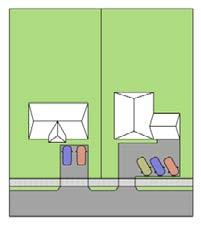
yard setback applicable to principal structures in the zone or district in which it is located.
(2) If off-street parking is located on a lot that does not contain a principal structure, the off-street parking area shall be considered a principal structure and shall conform to all setbacks applicable to principal structures in the zone or district in which it is located.
(3) Where serving a one-unit or two-unit dwelling use, a driveway may not exceed a width of 20 feet or the width of a garage to which it leads, whichever is greater. All driveways must follow the City’s Access Management Policies and Guidelines.
(4) All driveways must be set back from all side and rear lot lines by at least three (3) feet, except where a driveway adjoins a driveway of an adjacent lot. The area
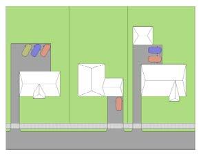
contained within the setback may not be paved.
(5) All off -street parking areas, including any vehicular accessways and any applicable parking lot perimeter landscaping strips, must be set back from all lot lines by at least three (3) feet, except where an off-street parking area adjoins an off-street parking area of an adjacent lot.
B. Parking Pad
No lot located in the R-1 Low Density Zone, R-2 Medium Density Zone, or PR Pedestrian-Residential District may contain more than one parking pad.
C. Landscaping for Parking Lots Not Fronting Wooster Street or Main Street
Any new parking lot, an expansion of an existing parking lot over 20 percent of the current square footage, an expansion of an
Interior Landscape IslandA,C
At least 1 interior landscape island must be installed for every 14 parking spaces or fraction thereof.
existing building by more than 20 percent of the GFA, or any new construction which does not front Wooster Street or Main Street and is more than 3,000 square feet in total size (not including the access drive) in any zone or district shall be landscaped in accordance with the Parking Lot Landscaping Table (Table 24).
D. Landscaping for Parking Lots Fronting Wooster Street or Main Street
Any new parking lot, an expansion of an existing parking lot over 20 percent of the current square footage, an expansion of an existing building by more than 20 percent of the GFA, or any new construction which includes parking located within the required front yard setback of lots fronting Wooster Street or Main Street shall be screened from the street right-of-way by the following elements:
(1) A planting strip between the fence and
Interior landscape island must be at least 9 ft. in width and at least 320 sq. ft. in area.
Perimeter LandscapingA,B
At least 1 tree and 4 shrubs must be planted for every 50 lineal ft. of parking lot perimeter.
Perimeter landscaping must be at least 5 ft. in width; perimeter landscaping may be reduced to 3 ft. in depth when a 3-foot-high masonry wall, wrought iron, or wood picket fence is erected on the outside edge of the perimeter.
Table 24: Parking Lot Landscaping Table. See regulation in Section 150.72, C.
AApplies only to parking lots of more than 3,000 square feet, not including access drives.
Interior landscape island must include one tree of at least 2-inch diameter per interior landscape island. Interior landscape islands, if multiple, must be distributed evenly throughout the parking area.
Shrubs must be at least 18 inches in height and capable of reaching a min. height of 3 ft. within 3 years of planting.
BDoes not apply to parking lots within the Central Business District or the Bowling Green Gateway District, or that front Main Street or Wooster Street that will have the required screening per 150.71(D).
CDoes not apply to parking lots solely used for heavy trucks.
piers and the public sidewalk. (Refer to Figure 27, Figure 28, and Figure 29.)
(a) Fifty (50) percent of the fence section shall include evergreen shrubs planted three (3) feet on center. Plant size to be fifteen (15) inches height minimum at time of planting and thirty (30) inches height maximum at maturity.
(b) The remainder of the frontage to be planted in deciduous shrubs or perennials planted twenty-four (24) inches on center. The maximum mature plant height shall be twenty-four (24) inches.
(c) The entire planting strip shall be included within a continuous hardwood mulch bed (minimum of three (3) inches deep).
(2) There shall be a t wo (2) foot wide overhang buffer strip between the right of way/back of pier and a concrete curb for any ‘head-in parking’ spaces along the buffer corridor. (Refer to Figure 27 and Figure 28.)
(3) A twenty (20) foot wide planting end cap island shall be installed between the parking bay and drive access. This island shall have a minimum fifteen (15) foot radius at the intersection of the drive aisle. (Refer to Figure 27 and Figure 28.)
(a) Low shrubs shall be massed within the island.
(b) The entire island shall be mulched with hardwood mulch (minimum of three (3) inches deep).
(c) The island shall contribute to any required parking island area otherwise required by this Zoning Code.
(4) A shade tree shall be planted every fifty (50) feet along the entire frontage. These trees shall be planted in a ten (10) foot wide planting island along with low shrubs. (See Figure 27 and Figure 28.)
(a) There shall be a maximum of five (5) nine-foot-wide parking spaces between planting islands along the corridor
frontage.
(5) An ornamental me tal fence with limestone piers as outlined below. (See Figure 29.)
(a) The fence shall be a four (4) foot industrial grade fence with four (4) rails (two (2) at the top and two (2) at the bottom).
(b) The post shall be three (3) inches by three (3) inches with a 0.125-inch wall thickness and shall have a ball finial.
(c) There shall be rings between the top two rails.
(d) The bottom of the fence shall not be enclosed.
(e) The rails shall be one and fiveeighths by one and five-eighths inches.
(f) The pickets shall be spaced three and three-quarter inches apart and shall have crimped tops.
(g) There shall be a maximum of four (4) eight-foot panel sections (32 feet maximum) between piers. These fence sections shall be of equal lengths.
(h) The color of the fence shall be black.
(i) The limestone piers shall be two (2) foot square and five (5) feet tall to the top of the capstone. The stone pattern shall be Fond du Lac Kensington Blend or approved equal. Mortar joints shall be heavily raked.
(j) The cap shall be limestone, and consisting of one piece - the bottom portion shall be two (2) feet, two (2) inches square and four (4) inches high, and the top portion shall be two (2) feet square and four (4) inches high with top two (2) inches and beveled on all four (4) sides.
(k) The entire assembly, including footings extending below the frost line, shall be designed by an architect or engineer.
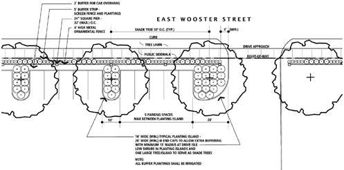
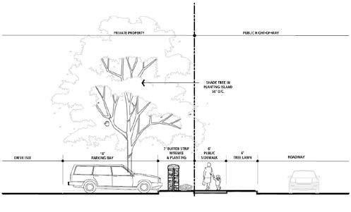
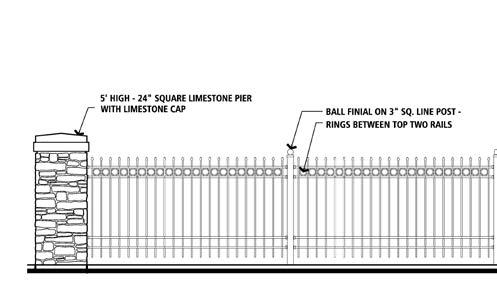
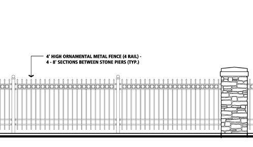
E. Paved off-street parking areas are included when calculating lot coverage. Parking lot landscaping areas are not included when calculating lot coverage.
F. Any off-street parking or loading space or driveway or storage area, for its entire length and area shall be of a hard, dustless surface (asphalt, concrete, brick paving blocks, porous pavement, or porous pavers) and drained according to sound engineering practices, and approved by the City Engineer.
G. Any parking area shall be maintained in a condition that provides a safe driving and walking surface.
H. Parking area drive aisles that facilitate two-way travel shall be a minimum of 24 feet in width in order to accommodate fire emergency response vehicles.
I. Off-street parking areas shall not discharge stormwater to adjacent properties, adjacent roadways, or storm sewer systems; all stormwater discharge from off-street parking facilities must be directed to detention basins, rain gardens, or dry wells.
J. Designated parking spaces shall be marked on the surface of the parking area with paint or permanent marking materials and maintained in a clearly visible condition.
K. Any parking space that (1) is associated with any use other than a one-unit or twounit dwelling and that (2) has a front or a rear end that abuts the perimeter of the parking area (or perimeter landscaping strip) must be equipped with a wheel stop.
(1) Each wheel stop shall be a singular block of durable material with a maximum height of six (6) inches and a maximum length of eight (8) feet.
(2) Wheel st ops are to be securely fastened to the ground and located no less than two (2) feet from the perimeter of the parking area and no less than four (4) feet from any structures, buildings, walls, or plant material, excluding ground cover.
L. For every use, except one-unit dwellings and two-unit dwellings, accessible parking spaces shall be provided as required in the Americans with Disabilities Act Section 208 and Section 502. The Americans with Disabilities Act can be reviewed at the United States Access Board website.
M. Any off-street parking space may be equipped with an electric vehicle charging station. The installation of an electric vehicle charging station does not change the principal use of a lot and shall be considered an accessory use of a parking lot, a parking structure, or a side yard or rear yard parking pad.
N. All required landscaping shall be maintained in a healthy condition, replacing it when necessary and keeping it free of refuse and debris.
A. In all zones and districts, bicycle parking must be provided on a lot where new construction or any alteration of an existing principal structure occurs or where a parking area is newly constructed or expanded and exceeds 6,000 square feet of parking area, even if such parking area is private or for lease only. Bicycle parking shall not be required on a lot with a one-unit dwelling or a twounit dwelling.
B. Bicycle parking spaces shall be provided at a rate of one (1) bicycle parking space per 6,000 square feet of motor vehicle parking area or fraction thereof, rounding up to the nearest whole bicycle parking space; however, not more than ten (10) bicycle parking spaces shall be required for any lot. The access drive to a motor vehicle parking area shall not be included in the calculation of motor vehicle parking area.
C. If one or more publicly installed bicycle parking space(s) is provided on the public right-of-way within 200 feet of a lot, such publicly installed bicycle parking space(s) shall contribute to the satisfaction of the minimum biycle parking spaces required by this section for that lot.
D. Bicycle parking areas shall be designed so that when fully occupied, bicycles, including bicycle trailers, shall not obstruct an adjacent sidewalk, path, or other pedestrian way.
E. Bicycle parking spaces shall be located not more than 200 feet from the main entryway into the principal structure. Alternatively, bicycle parking spaces may be located inside the principal structure if information about the structure’s hours of public access are clearly posted at the location of the indoor bicycle parking spaces.
F. Bicycle parking spaces should include infrastructure that allows a bicycle to be secured using a standard U-shaped
bicycle lock. Such infrastructure may be comprised of a bicycle rack, an enclosed bicycle storage compartment, a keyed indoor room, or a similar structure.
(1) The rack or similar structure should be secured to the ground or adjacent building in a way that reduces the risk of detachment by vandals, such as by anchoring the structure in concrete or by securing it to the pavement using antitheft-style nuts and bolts.
(2) The ra ck or similar structure must be reasonably accessible from the rightof-way by any users of the lot when maneuvering a standard bicycle. An area accessible only by steep stairwell, ladder, narrow hallway, or other confined space shall not be considered reasonably accessible while maneuvering a standard bicycle.
The parking of buses and commercial vehicles shall conform to the City’s traffic code.
A. The following requirements shall pertain to the location of loading berths:
(1) Loading or unloading may not interfere with, block access to, or encroach on fire and emergency vehicle lanes, sidewalks, or bike lanes.
(2) Lo ading areas must be located to the side or the rear of the building and may not be placed between the street and the building or any front façade of a building, except in the IE Innovation and Employment Zone.
B. Each off-street loading berth shall be designed with appropriate means of vehicular access to a street or alley in a manner which will least interfere with traffic movement.
C. Loading spaces that are constructed
below grade shall have a stormwater drainage system that complies with City engineering standards.
A. The following standards apply to all new or expanded drive-through facilities, and the addition of drive-through facilities on existing properties. The addition of a new drive-through lane constitutes an expanded drive through facility.
(1) No drive-thr ough menu board, stacking space, or pick-up window may be located within 100 feet of any lot occupied by a dwelling.
(2) If within 200 feet of a zone or district that lists dwellings as permitted uses, drive-throughs may not operate between the hours of 1:00 AM and 5:00 AM.
(3) Sta cking space. Drive-through stacking space requirements are intended to provide for queuing of vehicles in line for drive-through services provided by an establishment where drive-throughs are permitted in this Zoning Code. This provision provides for adequate space between vehicles and ensures that queuing vehicles are not stacking into public rights-of-way or easements and causing congestion therein.
(a) Queuing vehicles shall be located on the lot on which the drive-through services are being provided, shall not interfere with on-site parking or circulation, and shall not interfere with the circulation of the public roadway system.
(b) Each drive-through must contain a minimum of five (5) stacking spaces behind the menu board, or behind the pick-up window in the case that no menu board is provided.
(c) Each stacking space must be at least twenty (20) feet in length. Each stacking space must be at least ten (10) feet in width along straight segments
and at least twelve (12) feet in width along curved segments.
(4) Drive-thr ough lanes must be visibly striped along the outside boundary of the lanes and may not interfere with offstreet parking or the lanes utilized for maneuvering in and out of off-street parking spaces.
(5) All establishments with drive-throughs must provide a by-pass lane of at least eight (8) feet in width whereby vehicles may exit the lot at any point without proceeding through the drive-through lane.
(6) There must be one (1) trash receptacle provided per drive-through lane.
(7) Drive-thr ough lanes should be designed to avoid pedestrian walkways.
B. The following regulations shall apply to menu boards and directional signage within drive-through facilities:
(1) Menu board and directional signage within a drive-through facility does not require a zoning permit.
(2) A maximum of two (2) menu boards per drive-through aisle are permitted.
(3) Associated directional signage that gives directions to vehicles through the parking lot and drive-through is permitted.
(4) Dr ive-through directional signs may not be larger than five (5) square feet.
(5) Menu boards may not flash or have any visible bulbs or visible lighting elements.
(6) All menu bo ards must be oriented toward the drive-through aisle that they are serving.
(7) Drive-through speakers shall not emit outdoor music.
Dumpsters and other solid waste storage containers may not be located closer to the street right-of-way than the principal structure
on the lot, except that containers may be stored closer to the street right-of-way than the principal structure on the lot during a period within twenty-four (24) hours of a solid waste pick-up.
A. Except for lots in the Central Business District or the Bowling Green Gateway District which have parking areas fronting Main Street or Wooster Street and are regulated by Section 150.72.D: for any new development or an expansion of an existing building by more than 20% of GFA, street trees shall be planted at a rate of one (1) tree per forty (40) linear feet of frontage. A lot with less than forty (40) feet of frontage shall be required to plant a minimum of one (1) street tree. Existing street trees as determined in Section 150.78, B. or any trees planted by the City as part of a tree fee paid by a subdivider contribute to the fulfillment of this requirement.
B. The City will collect the applicable fee, as set forth in § 35.70 of the Bowling Green Code of Ordinances, for the required street tree(s). The Urban Forester will determine the type(s) and plant the street tree(s) in the City right-of-way in the proper location(s) adjacent to the applicable property address. The Urban Forester may provide an exemption to the requirement if there is not a suitable
location or if existing street tree(s) can count toward the requirement, provided that:
(1) Existing preserved trees are greater than two (2) inches in diameter;
(2) Existing vegetation is not an invasive species; and
(3) Existing vegetation is in good health or can reasonably be brought into good health.
The following are applicable to all fences erected on all property, except as otherwise set forth herein:
A. Except when fences are required by this Zoning Code for screening, a fence shall not exceed heights indicated in Table 25. When required by other provisions of this Zoning Code for screening, a fence shall be a minimum of six (6) feet in height.
B. Fence height at a given location along a fence line shall be the difference in elevation between the grade at the base of the fence and the top of the fence at that location. The grade at the base of the fence shall be the elevation of the ground surface before mounding or building-up of the ground surface, if any, occurred. If a fence occurs along a terraced portion of earth, such as a retaining wall, its height is measured from the higher
ft. max.; fences of more than 4 ft. in height in the side yard may not be extended closer to the street right-of-way than the front-facing elevation of any principal structure on the lot or an adjacent lot.
max. in any zone or district other than the IE District; 10 ft. max. in the IE District
ground elevation.
C. No fences shall be installed in the Vision Clearance Triangle.
D. Fence maintenance. All fences shall be maintained and in a safe and upright condition.
E. Fence permit. Any replacement of less than 50% of the length of an existing fence shall not require a fence permit.
F. All fences shall be installed so that, when a fence has a “finished,” “clean,” or “good” side, that side faces outward, toward adjacent lots; and the “unfinished” or “bad” side faces the interior of the lot. When a fence is installed on the property boundary between two lots, the “unfinished” or “bad” side shall face the lot of the landowner who is installing the fence.
G. Fence regulations for swimming pools, hot tubs, and retention ponds are described in Section 150.44.G.
A. Buffers are strips of land that provide insulation between incompatible neighboring land uses. The insulation is provided in the form of vegetation, earthen mounds, or opaque fences.
B. A buffer shall be provided as set forth in the Buffer Requirements by Zone or District, Table 26, for any new development or an expansion of an existing building by more than 20% of GFA. Buffer yard categories of Small, Large, and Mounding are defined in this section.
extending along 100% of the shared lot lines. Buffers may be broken where vehicle access-ways connect one lot to an adjacent lot.
D. It is not required that tree or shrub plantings be evenly spaced along the buffer. Tree or shrub plantings may be clustered.
E. A small buffer shall consist of a strip of land adjacent to the boundary of two zones or districts. The strip of land shall be 10 feet in depth. The strip of land shall be planted with at least three canopy or evergreen trees per 100 feet of length, at least two ornamental trees per 100 feet of length, and at least 10 shrubs per 100 feet of length.
C. Buffers shall be located along the outer perimeter of the lot, parallel to and Zone or District of Lot Adjacent to Proposed Development
Table 26: Buffer Requirements by Zone or District Table Legend: S = Small; L = Large; M = Mounding
F. A large buffer shall consist of a strip of land adjacent to the boundary of two zones or districts. The strip of land shall be 30 feet in depth. The strip of land shall be planted with at least five canopy or evergreen trees per 100 feet of length, at least four ornamental trees per 100 feet of length, and at least 20 shrubs per 100 feet of length.
G. Mounding shall consist of a four-foothigh vegetated, earthen mound. The mound shall have slopes no greater than 25 percent. The mound shall be erected between the principal structure or use area of a lot and the abutting incompatible zone or district. The ridge of the mound shall be planted with at least 20 shrubs per 100 linear feet, and the shrubs shall be of a variety that will mature to heights of at least six feet above the elevation of the ridge of the mound.
H. All dumpsters, except those temporarily located on the public right-of-way during an active construction activity, shall be screened by a fence of at least six (6) feet in height, 100% opacity, and made of brick, vinyl, or painted or stained wood.
A. Outdoor lighting intensity must be limited to reduce nuisances to neighboring uses and protect the night sky from light pollution.
B. All outdoor lighting, except sign illumination, shall comply with the following:
(1) Mea surements are to be made at ground level, with the light-registering portion of the meter held parallel to the ground pointing up.
(2) Lighting m ust not be oriented to direct glare or excessive illumination onto adjacent properties, streets or sidewalks.
(3) Be tween dusk and dawn, outdoor lighting other than sign illumination may not exceed a correlated color temperature
of 3000 Kelvins, in order to protect public health and wildlife.
(4) All lighting fixtures and poles within a common development shall be consistent in style, color, size, height, and design and are compatible with the architecture character of the development. Service connections for all freestanding lighting fixtures must be installed underground.
C. A photometric plan showing compliance with these standards shall be submitted along with all site plans for non-residential developments. The photometric plan may be incorporated into the site plan if all photometric plan components are included. The lighting plan shall include all of the following:
(1) All struct ure(s), parking spaces, building entrances, traffic areas (both vehicular and pedestrian);
(2) Vegetation that might interfere with lighting;
(3) Adjacent uses that might be adversely impacted by the lighting;
(4) All exterior lighting, including but not limited to, architectural, building-entrance, landscaping, flag, accent, etc.; and
(5) A layout of all proposed fixtures by location, orientation, aiming direction, mounting height and type.
D. The following exterior lighting is exempt from the requirements of this section:
(1) FAA-mandated lighting associated with a utility tower or airport;
(2) Lighting for the United States flag, Ohio flag, a County or City flag, a corporate flag, or any other flag;
(3) Fe stive lighting during the months of November, December, and January, provided the lighting does not create unsafe glare on street rights-of-way;
(4) Battery-powered emergency lighting;
(5) Architectural lighting using lamps of
800 lumens or less; and
(6) Public safety lighting.
Location or Use
R-1, R-2, R-3, MUN, PR, UR 0.5 footcandles max. at property line 15 ft. max.-
C, G, IE, I, R-C, A-1, CB, IC 2.0 footcandles max. at property line 30 ft. max.-
Parking lots 2.50 footcandles max. at property line 30 ft. max.Full cutoff fixtures required
Pedestrian areas 2.0 footcandles max. at boundary of pedestrian area 15 ft. max.-
Sports fields 50 footcandles max. at edge of play area 100 ft. max.
Under canopies5 footcandles max. N/A
(1) All lighting fixtures shall be equipped with an existing glare control package (e.g., louvers, shields, or similar devices) and aimed so that their beams are directed and fall within the primary playing or performance area only.
(2) The hours of operation for the lighting system for any game or event shall not continue more than one hour after the end of the game or event.
(1) Recessed fixtures must incorporate a lens cover that is either recessed or flush with the bottom of the canopy surface;
(2) Lighting fixtures must incorporate shields or must be shielded by the edge of the canopy itself;
(3) Surface mounted fixtures must incorporate flat glass that provides a cutoff design or shielded light distribution;
(4) Surface mounted fixtures may not measure more than 2 feet by 2 feet, with a lens cover that contains at least 2% white fill diffusion material; or
(5) Indirect lighting must be beamed upward and then reflected down from the underside of the canopy, provided the fixture is shielded so that direct illumination is focused exclusively on the underside of the canopy.
Flood lights and lamps N/A N/A
Table 27: Outdoor Lighting Regulations.
(1) Flood light fixtures must be either aimed down at least 45 degrees from the vertical or the front of the fixtures must be shielded so that no portion of the light bulb extends below the bottom edge of the shield.
(2) Any flood light fixture located within 50 feet of a street right-of-way must be mounted and aimed perpendicular to the right-of-way, with a side-to-side horizontal aiming tolerance not to exceed 15 degrees.
(3) All flood lamps emitting 1,000 or more lumens must be aimed at least 60 degrees down from horizontal or shielded so that the main beam is not visible from adjacent properties or the street right-of-way.
A. Each sign shall be kept in a safe condition and in good order and repair at all times, so as to constitute no danger or hazard to public safety. The use of bed linens, tarps, and untreated or unfinished plywood are prohibited.
B. No sign shall be erected, relocated, or maintained so as to prevent free ingress or egress from any door, window, or fire escape. No sign of any kind shall be attached to a fire escape.
C. The Planning Director shall cause the removal and/or repair of any sign found to be unsafe or defective to the extent that it creates an immediate and/or emergency hazard to persons or property.
D. It shall be unlawful for any owner of record, lessor, lessee, manager, agent, or other person having lawful possession or control over a building, structure, or lot to fail to maintain the property and all signage thereon.
E. In order to protect the public from safety hazards, any inflatable, flashing, blinking, moving, or fluttering element that is used to direct or command attention or emphasis from the right-of-way is prohibited.
F. No off-premise sign shall be permitted.
G. Electronic Message Center and Changeable Copy
(1) An electronic me ssage center shall not have any element that imitates motion, blinking, swiping, or changes in intensity.
(2) Copy changes must have a static hold time of at least ten (10) second.
(3) An electronic me ssage center may not have a brightness of more than 0.3 footcandles above ambient lighting conditions when measured at the appropriate distance from the sign. The brightness shall be measured using an
illuminance meter and shall be measured a distance from the sign equal to the square root of [100 times the sign area].
(4) No electronic message center sign shall be permitted in the Pedestrian Residential District.
H. Sign area is calculated as the area of the entire face of a sign, including the advertising surface and any framing, trim, or molding, but not including the supporting structure. For projecting or double-faced signs where the sign faces are parallel or where the interior angle formed by the faces is 60 degrees or less, only one display face shall be measured in computing sign area, provided that the two faces are attached to a common structure. If the two faces of a doublefaced sign are of unequal area, the area of the sign shall be taken as the area of the larger face.
I. Awning or Canopy Sign Regulations
(1) No Awning or Canop y Sign may be erected except with a permit.
(2) On ly one (1) Awning or Canopy Sign may be erected per building entrance.
(3) The sign area may not exceed 75% of the area of the awning’s sloped portion.
(4) For a Canopy Sign, the sign width may not exceed 75% of the width of the canopy.
(5) An A wning or Canopy Sign must maintain a minimum of 8 feet of clearance above a public or private sidewalk.
(6) An Awning or Canop y Sign may not be constructed of any material except for fabric or metal.
(7) Awnings are permitted over storefront windows and doors. No awning may be substantially wider than the storefront it covers. Awnings must be supported by the building facade and may not be supported by columns that impede pedestrian movement on a sidewalk or other pedestrian-way.
J. Building Identification Sign Regulations
(1) A permit is not required to erect a Building Identification Sign.
(2) No mor e than one (1) Building Identification Sign may be displayed per building entrance. No more than two (2) Building Identification Signs may be displayed per building.
(3) No Building Identification Sign may have a sign area that exceeds 6 square feet.
(4) No Building Identification Sign may be mounted higher than the top of the building entrance doorway.
(5) No Building Identification Sign may be displayed except for one constructed of wood or metal.
(6) No Building Identification Sign may display content other than that which identifies the name or address of the building or building tenants. While this Zoning Code regulates signs in a contentneutral manner, the content of Building Identification Signs is regulated in order to assist with the efficiency of emergency response.
K. Monument Signs Regulations
(1) No Monumen t Sign may be erected except with a permit.
(2) No more than one (1) Monument Sign may be displayed per street frontage per lot.
(3) No Mon ument Sign may have a sign area that exceeds 64 square feet.
(4) Mu lti-tenant signs are permitted on Monument Signs.
(5) No Mon ument Sign may have a sign height that exceeds 8 feet.
(6) No Monumen t Sign may be erected that does not have a base; no Monument Sign may have a base that is less than 2 feet in height. The solid supporting base must be equal to or greater than the
width of the sign face and be constructed of decorative and durable materials (e.g., masonry, brick, stone, or stucco). There must be no separation between the sign face and the base.
(7) A Monumen t Sign is required to be located a minimum of 5 feet from the rightof-way.
L. Projecting Sign Regulations
(1) No Projecting Sign may be erected except with a permit.
(2) No more than one (1) Projecting Sign may be erected per building entrance.
(3) No Projecting Sign may be erected unless the bottom of such sign is at least nine (9) feet above grade.
(4) No Projecting Sign that extends more than four (4) feet from the building face may be erected.
(5) No Projeting Sign may exceed a sign area of 16 square feet per sign face.
(6) No Projecting Sign may be erected except a Projecting Sign which is constructed of wood or metal.
(7) No Projecting Sign may be illuminated, except those that are externally illuminated.
M. Sandwich Board Sign Regulations
(1) A permit i s not required to display a Sandwich Board Sign.
(2) No Sandwich Boar d Sign may be displayed unless such sign is within 10 feet of a building entrance and does not obstruct pedestrian flow on a sidewalk or other pedestrian-way.
(3) No Sandwich Boar d Sign may be displayed which has a sign area that exceeds six (6) square feet per side.
(4) No Sandwich Boar d Sign may be displayed which has a sign width that exceeds two (2) feet.
(5) No Sandwich Boar d Sign may be
displayed which has a sign height that exceeds three (3) feet.
(6) No Sandwich Boar d Sign may be illuminated.
(7) No Sandwich Boar d Sign may be located within public right-of-way, except in the Central Business District after seeking and obtaining a permit from the City.
N. Temporary Sign Regulations
(1) A p ermit is required to display a Temporary Sign for commercial use in the C Commercial Zone, IE Innovation & Employment Zone, MUN Mixed-Use Neighborhood Zone, and IC Interstate Commerce District.
(2) No Temporary Sign shall be installed in the public right-of-way.
(3) No Temporary Sign may have a sign area that exceeds 12 square feet.
(4) No Temporary Sign may have a sign height that exceeds five (5) feet.
(5) No residential property of the same postal address may have Temporary Signs that, in total, have an aggregate sign area that exceeds 24 square feet. A business is allowed to have one (1) Temporary Sign per calendar year up to ninety (90) days. The time period can be split up into thirty (30) day increments for use throughout the calendar year.
(6) No Temporary Sign may be illuminated.
(7) A Tempor ary Sign may be flushmounted to a building or freestanding, but it cannot move (e.g., feather signs or inflatable signs, which are not permitted).
(8) A Real Estate Sign is not considered a Temporary Sign.
O. Wall Sign Regulations
(1) No Wall Sign may be erected except with a permit.
(2) No Wall Sign that extends more than nine (9) inches beyond the building face
may be erected.
P. Wayfinding Sign Regulations
(1) A permit is not required to erect a Wayfinding Sign.
(2) No Wayfinding Sign may have a sign height that exceeds three (3) feet or exceed three (3) square feet in size.
Q. Additional sign regulations are set forth for each zone or district. Such regulations are included in the following sections.
This section provides illustrations of some of the sign types used by this Zoning Code.


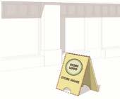
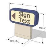

Zone/DistrictSign
Low Density
Residential (R-1)
Medium Density
Residential (R-2)
• Awning or Canopy Sign*
• Monument Sign*
• Projecting Sign*
• Real Estate Sign**
• Sandwich Board Sign*
• Temporary Sign**
• Wall Sign*
• Awning or Canopy Sign*
• Monument Sign*
• Projecting Sign*
• Real Estate Sign**
• Sandwich Board Sign*
• Temporary Sign**
• Wall Sign*
• Awning or Canopy Sign*
• Monument Sign*
• Projecting Sign*
Multi-Unit
Residential (R-3)
3 max.†
3 max.†
For residential uses: 10 sq. ft. For non-residential uses: 68 sq. ft. max., or [width of building front + 10] sq. ft. max., whichever is less
For residential uses: 10 sq. ft. For non-residential uses: 68 sq. ft. max., or [width of building front + 10] sq. ft. max., whichever is less
For residential uses: 15 sq. ft. max.
For nonresidential uses: 136 sq. ft. max.
For residential uses: 15 sq. ft. max.
For nonresidential uses: 136 sq. ft. max.
Commercial (C)
• Real Estate Sign**
• Sandwich Board Sign*
• Temporary Sign**
• Wall Sign*
• Wayfinding Sign*,** 3 max.†
• Awning or Canopy Sign
• Monument Sign
• Projecting Sign
• Real Estate Sign**
• Sandwich Board Sign
• Temporary Sign**
• Wall Sign
• Wayfinding Sign** 3 max.†
For residential uses: 10 sq. ft.
For non-residential uses: 68 sq. ft. max., or [width of building front + 10] sq. ft. max., whichever is less
For residential uses: 15 sq. ft. max.
For nonresidential uses: 136 sq. ft. max.
112 sq. ft. max., or [width of building front X 1.6, plus 40] sq. ft. max., whichever is less
336 sq. ft. max.
Table 28: Sign regulations table. *(Asterisk) indicates that such sign type is not permitted on lots with one-unit dwellings or two-unit dwellings. **(Double asterisk) indicates that such sign type does not count towards the number of signs allowed per business. †(Dagger or cross symbol) indicates a maximum of 2 signs are allowed if there are multiple businesses on the same parcel or located within the same building (i.e., a multi-tenant building or building with shared walls).
Zone/DistrictSign Types Permitted
Innovation & Employment (IE)
Mixed-Use Neighborhood (MUN)
• Awning or Canopy Sign
• Monument Sign
• Projecting Sign
• Real Estate Sign**
• Sandwich Board Sign
• Temporary Sign**
• Wall Sign
• Wayfinding Sign**
• Awning or Canopy Sign*
• Monument Sign*
• Projecting Sign*
• Real Estate Sign**
• Sandwich Board Sign*
• Temporary Sign**
• Wall Sign*
• No electronic message center signs are permitted in the MUN District 3 max.†
• Awning or Canopy Sign
• Building Identification Sign**
• Monument Sign
• Projecting Sign
Institutional (I)
or
of
For residential uses: 10 sq. ft. For non-residential uses: 68 sq. ft. max., or [width of building front + 10] sq. ft. max., whichever is less
For residential uses: 15 sq. ft. max.
For nonresidential uses: 136 sq. ft. max.
• Real Estate Sign**
• Sandwich Board Sign
• Temporary Sign**
• Wall Sign
• Wayfinding Sign**
Table 28: Sign regulations table (continued). *(Asterisk) indicates that such sign type is not permitted on lots with one-unit dwellings or two-unit dwellings. **(Double asterisk) indicates that such sign type does not count towards the number of signs allowed per business. †(Dagger or cross symbol) indicates a maximum of 2 signs are allowed if there are multiple businesses on the same parcel or located within the same building (i.e., a multi-tenant building or building with shared walls).
Zone/DistrictSign Types Permitted
Agricultural (A-1)
Recreational-
Conservation (R-C)
• Awning or Canopy Sign
• Monument Sign
• Projecting Sign
• Real Estate Sign**
• Sandwich Board Sign
• Temporary Sign**
• Wall Sign
• Awning or Canopy Sign
• Monument Sign
• Projecting Sign
• Real Estate Sign**
• Sandwich Board Sign
• Temporary Sign**
3 max.†
Pedestrian Residential (PR)
For residential uses: 10 sq. ft.
For non-residential uses: 68 sq. ft. max., or [width of building front + 10] sq. ft. max., whichever is less
For residential uses: 15 sq. ft. max.
For nonresidential uses: 136 sq. ft. max.
• Wall Sign 3 max.†32 sq. ft. max.64 sq. ft. max.
• Awning or Canopy Sign*
• Monument Sign*
• Projecting Sign*
• Real Estate Sign**
• Sandwich Board Sign*
• Temporary Sign**
• Wall Sign*
• No electronic message center signs are permitted in the PR District
3 max.†
For residential uses: 10 sq. ft.
For non-residential uses: 68 sq. ft. max., or [width of building front + 10] sq. ft. max., whichever is less
For residential uses: 15 sq. ft. max.
For nonresidential uses: 136 sq. ft. max.
Table 28: Sign regulations table (continued). *(Asterisk) indicates that such sign type is not permitted on lots with one-unit dwellings or two-unit dwellings. **(Double asterisk) indicates that such sign type does not count towards the number of signs allowed per business. †(Dagger or cross symbol) indicates a maximum of 2 signs are allowed if there are multiple businesses on the same parcel or located within the same building (i.e., a multi-tenant building or building with shared walls).
Zone/DistrictSign Types Permitted
University-Oriented
Residential (UR)
Interstate Commerce (IC)
• Awning or Canopy Sign*
• Monument Sign*
• Projecting Sign*
• Real Estate Sign**
• Sandwich Board Sign*
• Temporary Sign**
• Wall Sign*
• Awning or Canopy Sign
• Monument Sign
• Projecting Sign
• Real Estate Sign**
• Sandwich Board Sign
• Temporary Sign**
• Wall Sign
• Wayfinding Sign**
• Awning or Canopy Sign
• Monument Sign
• Projecting Sign
Central Business (CB)
Gateway (G)
• Real Estate Sign**
• Sandwich Board Sign
• Temporary Sign**
• Wall Sign
• Wayfinding Sign**
• Awning or Canopy Sign
• Building Identification Sign**
• Monument Sign
• Projecting Sign
• Real Estate Sign**
• Sandwich Board Sign
• Temporary Sign**
• Wall Sign
• Wayfinding Sign**
3 max.†
For residential uses: 10 sq. ft. For non-residential uses: 68 sq. ft. max., or [width of building front + 10] sq. ft. max., whichever is less
For residential uses: 15 sq. ft. max.
For nonresidential uses:
136 sq. ft. max.
3 max.†
112 sq. ft. max., or [width of building front X 1.6, plus 40] sq. ft. max., whichever is less
3 max.†
90 sq. ft. max., or [width of building front X 1.4, plus 20] sq. ft. max., whichever is less
336 sq. ft. max.
3 max.†
90 sq. ft. max., or [width of building front X 1.4, plus 20] sq. ft. max., whichever is less
Table 28: Sign regulations table (continued). *(Asterisk) indicates that such sign type is not permitted on lots with one-unit dwellings or two-unit dwellings. **(Double asterisk) indicates that such sign type does not count towards the number of signs allowed per business. †(Dagger or cross symbol) indicates a maximum of 2 signs are allowed if there are multiple businesses on the same parcel or located within the same building (i.e., a multi-tenant building or building with shared walls).
Any building or use which (1) exists at the time of the enactment of this Zoning Code and (2) conforms with the regulations of the Zoning Code in effect immediately prior to the enactment of this Zoning Code or is defined as a legal nonconforming use by the Zoning Code in effect immediately prior to the enactment of this Zoning Code but does not conform to the provisions of this Zoning Code for the zone or district in which it is located is considered a legal nonconforming building or use and may be continued. It is the intent of this section to permit these nonconformities to continue until they are discontinued or removed, but not to encourage their continuance or survival. Such uses are declared by this section to be incompatible with permitted uses in the district involved. It is further the intent of this chapter that nonconformities shall not be enlarged, expanded, or extended, or changed to any other nonconforming use, except as otherwise permitted herein or as approved by the Zoning Board of Appeals in accordance with the provisions specified in appropriate sections herein.
An existing nonconforming use may be hereafter extended throughout those parts of the building which were manifestly arranged or designed for such use at the time of the enactment of this Zoning Code. No building or premises containing a nonconforming use shall hereafter be extended unless such extension
shall conform to the provisions of the zone or district in which it is located and such extension is approved by the Zoning Board of Appeals as set forth in Section 150.105.
A. No building or lot where the intent of the owner to discontinue the use for a period of six (6) months or more is apparent or where a nonconforming use has been replaced by a use permitted in the zone or district in which such building or lot is located, shall again be devoted to any use not permitted in such zone or district.
B. If no structural alterations are made other than those necessary for maintenance, a nonconforming use of the building may be changed to another nonconforming use of an equal or more appropriate use for the zone or district in which it is located. Such determinations shall be made by the Planning Director and may be referred to the Zoning Board of Appeals for interpretation. In addition:
(1) Any change of one nonconforming use to a different nonconforming use shall only be permitted in parts of the building, structure, or premises where the previous nonconforming use had occurred.
(2) Whenev er a nonconforming use is changed to a conforming use, such use shall not thereafter be reverted to a nonconforming use.
(3) Any findings ma de by the Zoning Board of Appeals shall be made in a public hearing using procedures and requirements set forth in this Zoning Code.
No nonconforming structure shall be moved to another location on the same lot or any other lot unless the entire building, structure, facility or sign shall thereafter conform to the regulations of the zone or district in which it will be relocated. Moreover, no nonconforming land use shall be relocated, in whole or in part, to any other location on the same or any other lot unless such use shall thereafter conform to the regulations of the zone or district in which it is relocated.
Any nonconforming principal structure where 75% or more of its GFA above the foundations is damaged by fire, flood, explosion, earthquake, war, riot, or act of God or man shall not be reconstructed and used as before such casualty, unless such reconstruction and future use is in conformity with this Zoning Code. If less than seventy-five (75) percent of the GFA is so damaged, it may be reconstructed or used, provided that such reconstruction or use is accomplished within twenty-four (24) months of such casualty.
Any nonconforming accessory structure damaged by fire, flood, explosion, earthquake, war, riot, or act of God or man shall not be reconstructed and used as before such casualty, unless such reconstruction and future use is either (a) in conformity with this Zoning Code, or (b) accomplished within twenty-four (24) months of such casualty.”
A. Nothing in this Zoning Code shall prevent the strengthening or restoring to a safe condition of any part of any nonconforming building, structure, facility, or sign declared unsafe by the City or County.
B. If gravel or stone, a nonconforming offstreet parking area may be repaired and maintained, provided that the repair or maintenance does not expand or relocate the nonconforming off-street parking area.
C. If gravel or stone, a nonconforming offstreet parking area may be replaced with asphalt, concrete, or other similar paving material, provided that such replacement with asphalt, concrete, or other similar paving material is a complete replacement of the parking area and that no portion of the lot remains paved with gravel or stone and provided that the replacement does not expand the nonconforming portion of the off-street parking area.
D. If asphalt, concrete, or other similar paving material, a nonconforming offstreet parking area may be reconstructed with pre-approval from the City of Bowling Green Planning Department, provided that the reconstruction does not expand or relocate the nonconforming portion of the off-street parking area.
A. A sign, which is nonconforming on the effective date of this Zoning Code that does not conform with the regulations of this or a subsequent amendment, shall be deemed a nonconformity.
B. Any permanent graphic, sign, marquee, canopy, or awning, other than a temporary sign, which is deemed to be a nonconformity, and not erected pursuant to a City permit and in place on the
effective date of this chapter, and which remains or becomes a nonconformity upon the adoption of this chapter or any subsequent amendment thereto, may be continued only in accordance with the following regulations.
(1) Ordinar y repairs and nonstructural alterations may be made to a nonconforming sign. No structural alterations shall be made in, to, or upon such nonconforming sign, except those required by law to make the sign conform to the regulations of this chapter, unless the sign was erected pursuant to a City permit.
(2) A nonconforming sign shall no t be added to or enlarged in any manner, except to make the sign conform to the regulations of this Zoning Code and except when a variance is granted to allow such addition or enlargement.
(3) No nonconforming sign shall be moved in whole or in part to any other location unless such sign, and the use thereof, is made to conform to all regulations of this chapter.
A. It shall be unlawful for an owner, agent, or lessee to use or to permit the use of any structure, building, or land, or part thereof, hereafter created, erected, changed, converted, or enlarged, wholly or partly, until a zoning certificate shall have been issued by the zoning inspector. It shall be the duty of the zoning inspector to issue a certificate, provided they are satisfied that the structure, building, or premises and the proposed use thereof conforms to all the requirements of this chapter. The zoning inspector shall issue no permit for excavation or construction unless the plans, specifications, and the intended use conform to the provisions of this chapter.
B. Under written request from the owner, tenant, or optionee of the owner, the zoning inspector shall issue a zoning certificate for any building or premises existing at the time of the enactment of this Zoning Code certifying, after inspection, whether such use conforms to the provisions of this chapter. No charge shall be made for issuing a zoning certificate in accordance with this division.
C. A zoning certificate shall be valid for a period of one year from the date of application. Under reasonable and legitimate conditions, the zoning inspector may extend it for a period of one year. Such extension shall be noted on the original application.
D. A zoning certificate shall be issued for an expansion of a nonconforming building which conforms to the use regulations for the district in which it was situated provided the expansion of such building conforms to all setback requirements,
use regulations, and all other regulations in this Zoning Code.
E. Any improvements to any public right-ofway, public utility, or other public facility that is required as the result of the use of any structure, building, land or part thereof, hereafter created, changed, converted, or enlarged, wholly or partly, shall be financially guaranteed, by cash or bond, to the City prior to the issuance of a zoning certificate.
A. A zoning certificate shall be required for any of the following, except as herein provided.
(1) Construction or alteration of any building, including accessory buildings. Such construction or alteration shall include exterior modifications involving construction, reconstruction, or alteration but excluding painting, re-siding, reroofing, application of shutters or eaves spouting.
(2) Change in use of an existing building or accessory building to a use of a different classification or involving a change in required setbacks, screening, off- street parking or conditional use permit.
(3) Change in the use of land or buildings to a use of a different classification.
(4) Any change in the use of a nonconforming use.
(5) Erection of fences, swimming pools, and signs.
(6) Co nstruction of driveways and offstreet parking areas.
(7) If applicable , no zoning certificate
shall be issued unless a Certificate of Appropriateness (COA) is duly issued, under the provisions of Chapter 158 Historic and Architectural Preservation Code, by the Historic Preservation Commission and accompanies the application for a zoning certificate.
B. In all other situations where a minimum dollar amount of $2,500 is being expended on any building, structure, or land, a certificate of zoning compliance is to be obtained. There is a fee charged for a certificate of zoning compliance according to the adopted fee schedule, and application shall be made on form(s) available in the Planning Department.
A. Written application for a zoning certificate for the construction of a new building or for the alteration of an existing building shall be made at the same time as the application for a building permit. The certification shall be issued within ten days after a final inspection of the property and premises has been made by the zoning inspector or their agent, provided such construction or alteration is in conformity with the provisions of this chapter.
B. Written application for zoning certificate for the use of vacant land, or for a change in the use of land or of a building or for a change in nonconforming use, as herein provided, shall be made to the zoning inspector; if the application is complete and the proposed use is in conformity with the provisions of this chapter, the certificate shall be issued within 15 days after the final inspection of the property and premises for the same has been made.
C. Every application for a zoning certificate shall be accompanied by a plot plan drawn to scale which identifies: the
type of construction to take place, the location of the proposed construction, the measurements of the new construction from property lines and existing structures, the lot dimensions, the location and dimensions of all existing structures, including all impervious surfaces, and any other information as may be necessary to evaluate compliance with City Ordinances.
D. Every application for zoning certificate shall be accompanied by the applicable fee as set forth in Section 35.70 of the Bowling Green Code of Ordinances.
E. Every application for a zoning certificate, except for new one- and two-unit dwellings, additions or alterations to one- and two-unit dwellings, accessory structures associated with one- and two-unit dwellings, fences, signs, and changing the pitch of the roof, shall contain the following utilities information.
(1) Site bench mark. This shall meet the requirements of §12.02 of these Codified Ordinances.
(2) Existing ele vations on site and on adjacent properties. This information shall be sufficient to indicate directions of drainage flow.
(3) Proposed elevations.
(a) Finished grade at proposed building.
(b) Parking areas, drives, and alley improvements.
(c) Finished elevation and location of all grade changes of public sidewalks.
(4) Loca tions and sizes of all existing utilities (electric, natural gas, communication, water lines, storm sewers, and sanitary or combination sewers) and appurtenances thereto.
(5) Loca tions and sizes of any existing water and sewer service connections.
(6) Locations, sizes, types of material, and elevations of proposed sewers and water
lines.
(7) Loca tions of the proposed electric lines and tie to the electric system, electric service, and electric load.
(8) Locations of proposed natural gas and communication lines.
(9) Drawings shall show all right- of-way lines and property lines.
(10) All drawings must be prepared on reproducible paper.
(11) For plans of fiv e acres or less, the scale shall be an engineers scale, not less than one to 20. For plans for more than five acres, the scale shall be an engineers scale, not less than one to 40.
(12) All drawings must include a north arrow and legend that indicates existing and proposed electric, sewers, waterlines, and elevations.
(13) A note shall be on each plan to indicate that all construction and materials must meet the requirements of the city.
(14) A registered engineer shall prepare the drawing for new construction on vacant parcel(s) and the registered engineer shall seal the drawing.
(15) Complet ed stormwater pollution prevention plan forms as required by the storm design requirements of the city.
(16) Plans and calculations a ddressing storm detention, water quality volume, and storm sewers.
(17) After final approval by the City, the developer must supply the city with six (6) prints of the final drawings. Two approved sets of plans will be returned to the applicant and the applicant shall keep one set of approved plans on-site during construction. The developer must also supply the city with the final drawings in an electronic format compatible with the city’s computer assisted drawing program. The electronic copy shall be provided on a CD or other media acceptable to the
city. If applicable, the developer must also supply the city with two (2) prints and an electronic copy of the completed building plans depicting layout configurations and fire suppression information.
(18) Once the project is comple te, the developer must supply the city with two (2) copies of the “as built” plans. The developer must also supply the city with the “as built” plans in an electronic format compatible with the city’s computer assisted drawing program. The electronic copy shall be provided on a CD or other media acceptable to the city.
A zoning certificate shall be obtained for any lawful nonconforming building or use of land which is made nonconforming by the adoption of this Zoning Code. Application for such certificates for nonconforming use shall be filed with the zoning inspector by the owner or lessee of a building or land occupied by such nonconforming use within three years of the effective date of this Zoning Code. It shall be the duty of the zoning inspector to issue a certificate for a lawful nonconforming use and such certificate shall be conclusive evidence that the nonconforming use was lawfully in existence immediately prior to the effective date of this Zoning Code. No charge shall be made for issuing the zoning certificate in accordance with this section.
A. Before the zoning certificate is issued, the application, drawings, and plot plans required by 150.94 shall be submitted to the Utilities Executive Director. The Utilities Executive Director shall examine the application, drawings, and plot plans with respect to the water supply, electrical supply, and sewage disposal
facilities set forth therein. If the plans, drawings, and application as submitted show water supply, electrical supply, and sewage disposal facilities which are in accordance with the specifications of the Board of Public Utilities, the Utilities Executive Director shall approve the application, drawings, and plans as to utilities.
B. If any part of the proposed utilities installation is not in accordance with the specifications of the Board of Public Utilities, the Utilities Executive Director shall return the plans with recommendations for changes necessary to make them conform to the requirements of the Board of Public Utilities.
C. No zoning certificate shall be issued unless the plans, drawings, and application shall have been approved by the Utilities Executive Director as herein provided.
D. The Utilities Executive Director shall not approve any application for zoning certificate until the site has obtained all necessary permits, approvals, and easements required for full conformity with § 50.02 of the Code of Ordinances of the City of Bowling Green, Ohio.
The applicant will be notified in writing of any deficiencies in the completeness of the application and shall have thirty (30) days from the date thereof to correct any deficiencies and complete the application. If the deficiencies in the completeness of the application are not corrected within thirty (30) days, the application shall be deemed null and void, and any application fees will be forfeited to the City.
All interpretations of and decisions made under this Zoning Code not requiring the review and decision by the Planning Commission, the Board, or Council shall be made by the Planning Director, including interpretations of zone and district boundaries as indicated in Section 150.11.
All requests for a decision or approval under this Zoning Code begin with the property owner or an agent thereof, such as an architect or attorney, filing an application with the Planning Director on forms provided by the Planning Director and amended from time to time.
Uses set forth in any zone or district as conditional uses require a conditional use approval prior to the issuance of a zoning certificate. When an application for conditional use approval is submitted to the City, the Planning Director shall review the conditional use approval application. In order to grant a conditional use approval and zoning certificate, the Planning Director must first find, according to their professional opinion, that:
A. Adequate ingress and egress is provided;
B. The proposed use is not likely to pose a greater threat to public safety or health than all other uses listed as permitted by right for that zone or district;
C. The proposed use is not likely to overburden government services, such as police, fire, sewer, water, and other infrastructure;
D. The proposed use is not likely to cause a greater negative impact on the environmental quality than all other uses listed as permitted by right for that zone or district;
E. The proposed use does not conflict with objectives set forth in the most current adopted comprehensive plan; and
F. The conditional use will not substantially diminish or impair property values within its immediate vicinity.
If the Planning Director determines that one or more of the above criteria are not met by the proposed conditional use, the Planning Director may establish specific requirements of the proposed conditional use as conditions of the issuance of a conditional use approval and zoning certificate. The specific requirements may include, but are not limited to, more restrictive setbacks, buffers, hours of operation, noise transmission, height limits, and parking provisions. These specific requirements shall be recorded on the conditional use approval and zoning certificate at the time of issuance and shall remain in effect until the use becomes a listed permitted use through a Zoning Code amendment or until a new zoning certificate is issued for the lot.
Appeals from any determinations of the Planning Director shall be made to the Zoning Board of Appeals.
A. The Board shall have the power to hear and decide applications for appeals, exceptions, variances, conditional uses, extensions of use on the border of a zone or district, determination of a zone or district border in the case of differences in actual layouts and the map, and temporary uses and structures, all in accordance with the provisions of this chapter.
B. Such applications for appeals, exceptions, variances, conditional uses, extensions of uses on the border of a zone or district,
or determinations of a zone or district border in the case of differences in actual layouts and the map shall be brought to the Board by the property owner of each lot subject to the proposed use or determination.
C. The Board shall also have the power to hear and decide on appeals of actions of the Floodplain Administrator and any enforcement of the housing code or building code, as specified in Chapter 152 of the City of Bowling Green Code of Ordinances.
D. The Board shall also have the power to grant variances to the noise ordinance, as specified in Chapter 132 of the City of Bowling Green Code of Ordinances.
A. Members of the Zoning Board of Appeals shall be constituted and selected as provided in Charter § 7.03 and § 30.113 of the Codified Ordinances.
B. The Board shall organize annually to elect a chairperson, a vice-chairperson, and a secretary. It shall further adopt rules for its own government not inconsistent with the Zoning Code, the Charter of the City, general law, or any other ordinance of the municipality to carry into effect the provisions of this chapter.
C. Meetings of the Board shall be held at the call of the chairperson and at such other times as the Board shall determine. The chairperson, or in his or her absence, the vice-chairperson, may administer oaths and the Board may compel the attendance of witnesses. All Board meetings shall be open to the public. The Board shall keep minutes of its proceedings showing the vote of each member upon each question, or if a member is absent or failing to vote, indicating such fact, and shall keep records of its examinations and other
official actions, all of which shall be filed in the office of the Planning Department within seventy-two (72) hours after each meeting, examination, or other official action. A court stenographer shall take the verbatim testimony of all persons testifying at a zoning hearing, which shall be available to any party upon paying the cost thereof to the court stenographer. In event of appeal, the transcript shall be made for the Board by the court stenographer and shall be taxed to the applicant as part of the costs in the appeal.
D. Four (4) members of the Board shall constitute a quorum. The Board shall act by resolution, and the concurring vote of a majority of the members of the Board present shall be necessary to reverse any order of determination of the Planning Director or to grant any variance from the requirements of this chapter.
E. If any member of the Board shall be an owner, part owner, partner, or shareholder of an owner, part owner, tenant, or optionee of any premises for which an application is pending before the Zoning Board of Appeals for variance or by way of appeal or shall be financially interested in the sale or development of any such property, they shall not serve on the Board in making any determination with respect to such property.
F. The Board may call upon the various departments of the municipality for assistance in the performance of its duties and it shall be the duty of such departments to render such assistance to the Board as may reasonably be required.
G. The Board shall fix a reasonable time for the hearing of an appeal or for the hearing on any application on which the Board has original jurisdiction.
H. Notice of the hearing on an appeal, or on any application for variance or exception shall be given by publishing once in a newspaper of general circulation in
the city at least five (5) days prior to the hearing, and by posting in accordance with the administrative code. Notice in writing shall be sent by first class mail mailed at least ten (10) days before the hearing to the owner of the property for which the certificate, variance, or exception was requested, to all adjoining property owners, and to the applicant or appellant. A notice that an appeal or application for a variance or exception is pending shall be displayed on the property before the hearing.
I. The hearing of the Board shall be public. The Board may go into executive session for discussion but must take all official action in public.
J. On the day for hearing an application or appeal, the Board may adjourn the hearing to permit the obtaining of additional information or to cause such further notice as it deems proper to be served upon such other property owners or parties in interest it decides may be substantially interested in the application or appeal. In the case of an adjourned hearing, persons previously notified, and persons already heard need not be notified of the time of the resumption of the hearing unless the Board so decides.
A. An appeal from a decision of the Planning Director accompanied by the applicable fee as set forth in Section 35.70 of the Bowling Green Code of Ordinances.
B. The fees payable under this section shall be paid by the appellant to the fiscal court of the city for deposit to the credit of the general fund. Copies of proceedings and transcripts shall be made available at the cost of preparing such reproductions.
A. An appeal may be taken from a decision of the Planning Director with respect to the interpretation of or decision made under this chapter, or from the decisions of the Historic Preservation Commission under Chapter 158. Such appeal may be taken to the Board by any person aggrieved, or his or her agent, or by any officer of the City affected by such decision of the Planning Director, the City Attorney, or the Historic Preservation Commission. Appeals to the Board shall be filed within twenty (20) days after the decision of the Planning Director by filing a written notice of appeal to the Board. An appeal stays all proceedings to furtherance of the action appealed from, unless the Planning Director from whom the appeal is taken certifies to the Board after the notice of appeal is filed with him or her, that by reason of facts stated in the application, a stay would in his or her opinion, cause imminent peril to life and property. In such case, proceedings shall not be stayed other than by a restraining order which may be granted by the Board or by a court of record on application, on notice to the Planning Director from whom the appeal is taken on due cause shown.
B. An appeal shall stay all proceedings in furtherance of the action appealed from unless the Planning Director shall certify to the Zoning Board of Appeals, after the notice of appeal shall have been filed with it, that by reason of facts stated in the certificate a stay would, in their opinion, cause imminent peril to life or property; in which case proceedings shall not be stayed otherwise than by a restraining order from a court of general jurisdiction.
C. The Board may, in conformity with the provisions of this chapter, reverse or affirm, wholly or in part, or may modify the order, requirement, decision, or
determination appealed from and shall make such order, requirement, decision, or determination as in its opinion ought to be made in the premises; and to that end, shall have all powers of the Planning Director from when the appeal is taken.
The Board may grant the following extensions:
A. An extension of a nonconforming building upon a lot occupied by such building or on an adjoining lot, provided that such lot was under the same ownership as the lot in question at the time the use of such building became nonconforming, and that such extension is necessary and incidental to such existing nonconforming use; and provided that the extent of such extension shall not exceed in all twenty (20) percent of the existing ground floor area of the existing building devoted to a nonconforming use and that such extension shall be within a distance of not more than twenty-five (25) feet of the existing building or premises, and provided further only one (1) such extension will be permitted.
B. An extension of a use or building into a more restricted district immediately adjacent thereto but not more than twenty-five (25) feet beyond the dividing line of the two (2) zones or districts, under such conditions as will safeguard development in the more restricted zone or district.
C. An extension of a use or building into a more restricted zone or district when the district boundary divides a lot or lots in single ownership at the time of the adoption of this chapter. Such extension shall not be for more than twenty-five (25) feet or to the edge of the divided lot, whichever is greater.
Under a temporary and revocable permit, the temporary use of a structure or premises for a purpose or use that does not conform to the regulations prescribed elsewhere in this Zoning Code is permitted; provided that such use be of a temporary nature and does not involve the erection of a permanent or substantial structure that would require a building permit under applicable law. A temporary and revocable permit may be issued for not more than a twelve (12) month period, subject to such conditions as will safeguard the public health, safety, convenience, and general welfare.
A. The Board shall have original jurisdiction to grant variances from the provisions or requirements of this Zoning Code.
B. Criteria for Granting a Variance
In order to grant a variance to a numerical provision, the Board must find that the strict application of the Zoning Code would create practical difficulties for the property owner. In exercising its variance power, the Board may impose such reasonable conditions upon the applicant as it deems necessary to accomplish the purposes of this chapter. An application must present credible evidence of the following so that the Board may determine whether sufficient practical difficulties exist to warrant the variance. When determining whether the strict application of the Zoning Code would create practical difficulties for the property owner, the Board shall consider:
(1) Whether the property in question will yield a reasonable return or whether there can be any beneficial use of the property without the variance;
(2) Whether the variance is substantial;
(3) Whether the essential character of the neighborhood would be substantially altered or whether adjoining properties would suffer a substantial detriment as a result of the variance;
(4) Whether the variance would adversely affect the delivery of governmental services (e.g., water, sewer, garbage);
(5) Whe ther the property owner purchased the property with knowledge of the zoning restriction;
(6) Whether the pr operty owner’s predicament feasibly can be obviated through some method other than a variance, and;
(7) Whether the spirit and intent behind the zoning requirement would be observed and substantial justice done by granting the variance.
Appeals from the Zoning Board of Appeals shall be made to the Wood County Court of Common Pleas as provided by R.C. § 2506, et seq.
The Planning Commission is established and has the powers and duties granted by Chapter 713 of the Ohio Revised Code and the City of Bowling Green Code of Ordinances Sections 7.02 and 30.106.
Whenever the public necessity, convenience, general welfare, or good zoning practice require, the Council may, by ordinance, after receipt of recommendation thereon by the Planning Commission, and subject to the procedure prescribed by general law and by the Charter of the City, amend, supplement, or change the regulations, district boundaries,
or classification of property now or hereafter established by this chapter or amendments thereof. It shall be the duty of the Commission to submit its recommendations regarding all applications or proposals for amendments to the Council.
A. Applications for any change of district boundaries or classifications of property as shown on the zoning map shall be submitted to the Commission by the Commission, itself, the Council, or the property owner of the property proposed to be reclassified.
B. Upon filing the request for change in classification, the applicant, at their expense, shall erect a sign or signs conforming to the requirements below, legible from the public right-of-way, measuring two (2) feet by four (4) feet, at the property requested for change in classification the same day the application is filed. If the required sign(s) are not in place, the request shall be returned to the applicant as incomplete and not placed on the Commission’s agenda. In the case of parcels with frontage on more than one (1) public street, a minimum of one (1) sign shall be provided for each public street. In any event, one (1) sign shall be provided for every 600 feet of frontage. The sign shall give the applicant’s name, address, and telephone number and the present zoning classification. The sign shall state that the information concerning the request is on file at the Planning Commission’s public office and is available for inspection during normal business hours. The required signs shall remain in place until forty (40) days after final action on the legislation when they shall be removed by the applicant. Applications for amendments initiated by the Commission shall be accompanied by its motion
pertaining to such proposed amendment.
C. Before submitting its recommendations on a proposed amendment to Council, the Planning Commission shall hold a public hearing thereon. Notice of such hearing shall be given by one (1) publication in a newspaper of general circulation in the city and shall also be posted as provided in the City’s administrative code. The notice shall state the place or places where, and time when, the proposed amendment to the ordinance, including text and maps, may be examined, and the time and place for the public hearing.
D. If the proposed ordinance, measure, or regulation intends to rezone or redistrict ten (10) or fewer parcels of land as listed on the tax duplicate, notice of the hearing shall be mailed by the Planning Director by first class mail at least twenty (20) days before the date of the public hearing to the owners of property within, contiguous to, and directly across the street from such parcel or parcels, to the addresses of such owners appearing on the county auditor’s current tax list or the treasurer’s mailing list. Failure to receive notice as provided in this section shall not invalidate any such ordinance, measure, or regulation.
E. The Commission may call upon the various departments of the municipality, upon the Planning Director, or upon expert consultants for assistance in the performance of its duties, and it shall be the duty of such departments or staff to render such assistance to the Commission as may reasonably be required.
F. The Commission may recommend that the application be granted as requested, or it may recommend a modification of the zoning amendment requested in the application, or it may recommend that the application not be granted. The Commission’s recommendation shall be certified to Council.
G. After receiving the Planning Commission’s recommendations on the proposed amendment, and before acting on such amendment, the Council shall hold a public hearing thereon in accordance with the provisions of R.C. § 713.12. Council shall set the date of such hearing and shall give at least thirty (30) days’ notice of the time and place thereof in a newspaper of general circulation in the municipal corporation by publication twice. If the ordinance, measure, or regulation intends to rezone or redistrict ten (10) or fewer parcels of land, as listed on the tax duplicate, written notice of the hearing shall be mailed by the clerk of the legislative authority, by first class mail, at least twenty (20) days before the date of the public hearing to the owners of property within and contiguous to and directly across the street from such parcel or parcels, to the addresses of such owners appearing on the county auditor’s current list, or the treasurer’s mailing list, and to such other list or lists that may be specified by the legislative authority. The failure of delivery of such notice shall not invalidate any such ordinance, measure, or regulations. Notice shall be posted as provided by the administrative code. During such thirty (30) days, the text or copy of the text of such ordinance, measure, or regulations, together with the maps, plans, or copies thereof forming part of or referred to in such ordinance, measure, or regulation, and the maps, plans, and reports submitted by the Planning Commission, board, or officer shall be on file for public examination in the office of the clerk of the legislative authority or in such other office as is designated by the legislative authority.
H. No ordinance, measure, or regulation which violates, differs from, or departs from the plan or reports submitted by the Planning Commission shall take effect unless passed by a vote of four (4) members of Council. No ordinance, measure, or regulation which is in
accordance with the recommendation, plan, or reports submitted by the Planning Commission shall be deemed to pass or take effect without the concurrence of at least a majority of the members elected to Council.
I. In order to partially defray the costs of processing a property owner’s application for a change of the official zoning map, a fee as set forth in Section 35.70 of the Bowling Green Code of Ordinances must accompany the application. Under no conditional shall any of the aforementioned fee be or any part thereof be returned to the applicant for failure of the application.
J. If the application for change in zone or district, or for other change in the Zoning Code, originates in the Planning Commission on its own action without application from a property owner, no fee shall be charged.
After approval of an annexation by the Wood County Board of Commissioners, the Planning Director will examine the existing zoning on the parcel and will present a written report to the Planning Commission as to the zone classification in the city which most nearly corresponds to the present zoning of the parcel. If the parcel is not zoned, the Planning Director will certify to the Commission that zone classification in this chapter that most nearly corresponds to the present use of the parcel. The Planning Commission will consider the Planning Director’s report and, without public hearing, will recommend to Council interim zoning for the parcel which, in the opinion of the Commission, is most consistent with the existing zoning, existing use of the land, or a classification that implements the land use envisioned by the City’s future land use plan. The Planning Commission’s recommendation shall be considered by Council following the procedure set forth for a map amendment
herein. The interim zoning established shall remain in effect until amended. The procedure for change in interim zoning to permanent zoning shall be the same as for any district change, but the Planning Commission in considering permanent zoning shall consider all matters, including the wishes of the property owners of the parcel, the orderly development of the area, and the goals established for development in the master plan.
A. The Planning Director or their designee shall enforce this Zoning Code. It shall be the duty of all officials and employees of the municipality to assist the Planning Director by reporting to them any new construction, reconstruction, or land uses or apparent violations.
B. In case any building is or is proposed to be located, erected, constructed, reconstructed, enlarged, changed, or maintained, or used, or any lot is or is proposed to be used in violation of this chapter or any amendment or supplement thereto, the Planning Director or the legal representative of the municipality may institute injunction, mandamus, abatement, on any other appropriate action, actions, proceeding, or proceedings to prevent, enjoin, abate, or remove such unlawful location, erection, construction, reconstruction, enlargement, change, maintenance, or use.
C. Any person, firm, or corporation violating any regulation in or any provision of this chapter or any amendment or supplement thereto, shall be fined not more than $500 for each offense. Each day during which such illegal location, erection, construction, reconstruction, enlargement, change, maintenance, or use continues, may be deemed a separate offense. If the offender has previously been convicted of any violation
of this chapter, then any such subsequent violation shall be a misdemeanor of the second degree.
A.
ACCESSORY DWELLING USE. A dwelling unit that facilitates a dwelling use accessory to a principal use of a lot. An accessory dwelling use may be customarily associated with a one-unit dwelling use, a place of religious assembly use, a professional office use, or an agricultural use.
ACCESSORY STRUCTURE. Any structure of more than 100 square feet of GFA, other than a principal structure, used to facilitate an accessory use. Accessory structures include utilities above or below ground, such as all necessary pumps, transformers, distribution structures or terminals, and any generation, exchange, or treatment facility; garages, patios, detached decks, storage buildings, sheds, all swimming pools, terraces, and rain gardens. An accessory structure must be located on the same lot as the principal structure to which it is accessory, unless a variance is granted by the Zoning Board of Appeals. A structure that is functionally attached to the principal structure, such as a deck or porch to a principal dwelling, is treated by this Zoning Code as an extension of the principal structure and is not considered an accessory structure.
ACCESSORY USE. All activities that occur within an accessory structure of more than 100 square feet of GFA that are incidental to the principal use of the land or principal structure on the lot. An accessory use includes outdoor living uses; home occupations; and household agriculture.
ADDICTION TREATMENT FACILITY. Any building, structure, or space whose principal or primary function is the reception, housing, and/or care of
chemically dependent adults and/or their minor children, and by which distribution of synthetic narcotics or any other method attempts to control, suppress, and/or eliminate a person’s mental or physical dependence on any illegal or harmful substance.
ADJACENT. As it applies to structures, adjacent means touching or so close that it functions as attached.
ADULT BOOK STORE. An establishment which utilizes 25% or more of its retail selling area for the purpose of retail sale or rental, or for the purpose of display by coin or slug-operated, or electronically, electrically, or mechanically controlled still or motion picture machines, projectors, or other image-producing devices, or both; books, magazines, other periodicals, films, tapes and cassettes which are distinguished by their emphasis on adult materials as defined in this section.
ADULT CARE FACILITY. A residence or facility, licensed by an agency of the State of Ohio, that provides accommodations from three to 16 unrelated adults and may provide supervision and personal care. An adult care facility is not a rooming house, boarding house, or dormitory as defined in this section.
ADULT DRIVE-IN MOVIE THEATRE. An open-air drive-in theatre which is regularly used or utilized 15% or more of its total viewing time, for presenting material distinguished or characterized by an emphasis on matter depicting, describing, or related to adult material as defined in this Zoning Code.
ADULT ENTERTAINMENT BUSINESS or SEXUALLY ORIENTED BUSINESS. An adult bookstore, adult motion picture theater, adult drive-in movie theatre, or an
adult-only entertainment establishment as further defined in this section.
ADULT MATERIAL. Any book, magazine, newspaper, pamphlet, poster, print, picture, slide, transparency, video tape, figure, image, description, motion picture film, phonographic record, or tape, other tangible thing, or any service, capable of arousing interest through sight, sound, or touch; and
(1) Which mat erial is distinguished or characterized by an emphasis on matter displaying, describing, or representing sexual activity, masturbation, sexual excitement, nudity, bestiality, or human bodily functions of elimination; or
(2) Which ser vice is distinguished or characterized by an emphasis on sexual activity, masturbation, sexual excitement, nudity, bestiality, or human bodily functions of elimination.
ADULT MOVIE THEATER. An enclosed motion picture theater which is regularly used or utilized 15 percent or more of its total viewing time, for presenting material distinguished or characterized by an emphasis on matter depicting, describing or related to adult material as defined in this section.
An establishment where the patron directly or indirectly is charged a fee where the establishment features entertainment or services which constitute adult material as defined in this section, or which features exhibitions, dance routines, or gyrational choreography of persons totally nude, topless, bottomless, or strippers, male or female impersonators or similar entertainment or services which constitute adult material.
AGRICULTURE. Farming, dairying, pasturage, apiculture, plant cultivation, viticulture, animal and poultry husbandry, sod farming, and furbearing animal production.
AGRICULTURAL ANIMALS. Animals normally associated with agriculture including, but not limited to, cattle, goats, horses, poultry, rabbits, sheep, and swine. Domestic dogs and cats are not agricultural animals, but household pets.
AIRPORT. Any area of land or water designated, set aside, used, or intended for use, for the landing and take-off of aircraft, and any appurtenant areas designated, set aside, used, or intended for use, for airport buildings or other airport facilities, rightsof-way, or approach zones, together with all airport buildings and facilities located thereon.
ALLEY. A public right-of-way which yields secondary access to a lot.
ALTERATION. Any change in the supporting members of a building such as, but not limited to, bearing walls, columns, beams, girders, and roofs.
ANIMAL SERVICES. Activities for housing, training, exercising, and providing a medical service for large and small animals, including any outside runs, kennels, or training areas. This use excludes dog parks.
ARTISAN MANUFACTURING. An establishment, not exceeding 3,000 square feet of floor area, for the preparation, display, and sale of individually crafted artwork, jewelry, furniture, sculpture, pottery, leathercraft, hand-woven articles, or related items.
LARGE. A use in excess of two acres providing services to personal vehicles and the trucking industry, which may include but not limited to the following activities: dispensing of fuel, repair shops, automated washes, restaurants, and motels; all as part of the facility.
REFUELING STATION, SMALL. Any use up to two acres devoted to the sales of gasoline, diesel, kerosene, liquified natural gas, electricity, and other
B.
automotive products and with not more than three (3) stalls or bays devoted to the repair or servicing of motor vehicles.
AUTOMOTIVE REPAIR GARAGE. A land use involving the repair and servicing of motor vehicles. The sale of gasoline and supplies may be considered incidental to the repair and servicing function.
AUTOMOTIVE SALES. A land use devoted to the display and retail sales or leasing of automobiles and motor vehicles and their add-ons, such as trailers, including repair or servicing of motor vehicles.
AUTOMOTIVE WRECKING, TOWING, or IMPOUNDING. The towing or storage of motor vehicles or motor vehicle parts, or the disassembly thereof. This activity shall not include the assembly, processing, or smelting of motor vehicles or other parts or products.
AWNING. Any structure made of cloth, wood, or metal having a metal or wooden frame, being attached to a building and carried by a frame supported by the ground or sidewalk. The uppermost surface of the awning exposed to the elements may have a slope that exceeds 20 percent.
AVERAGE GRADE PLANE. A reference horizontal plane representing the average of finished ground level adjoining the structure or building at all exterior surfaces.
AWNING SIGN. A projecting sign made of non-rigid material such as heavy canvas supported by a framework that is attached to a building’s substrate. The awning sign extends outward from the building and so provides shaded cover and protection from weather for customers and pedestrians. An awning sign will have lettering and/or graphics painted or screen printed on its exterior surface. It may or may not be illuminated.
BAR or TAVERN. An establishment
devoted primarily to the sales and onpremises consumption of alcoholic beverages. Food service may be provided, but is secondary to the sale of alcoholic beverages. Indoor entertainment is included as an incidental use within this term, unless such entertainment qualifies as an adult entertainment business.
BARBER SHOP or BEAUTY SHOP. See DAY SPA.
BED AND BREAKFAST INN. An owneroccupied one-unit dwelling in which rooms are rented to paying transients or travelers on a nightly, weekend, or weekly basis, with only breakfast being served.
BEDROOM. A space located in a dwelling and which is a minimum of 70 square feet, measured not including closet space. A bedroom is not a hall, bathroom, kitchen, living room, dining room, family room, laundry room, attic, or closet or dressing room opening off a bedroom. A bedroom is used primarily for sleeping purposes. In order for a room to be considered a bedroom, it must also meet the description of bedroom in the Wood County Building Code.
BOTTOMLESS. Less than full opaque covering of male or female genitals, pubic area, or buttocks.
BUILDING. Any structure, including a roof supported by walls, designed or built for the support, enclosure, shelter, or protection of persons, animals, or property.
BUILDING FACE or FACADE. The outside flat surface of a building or structure. A building face does not include awnings, canopies, sills, and other projections of a similar nature.
BUILDING HEIGHT or STRUCTURE HEIGHT. The vertical distance between the average grade plane of the structure and the highest point of any flat roof or the midpoint of any pitched roof.
BUILDING IDENTIFICATION SIGN. A
C.
sign giving the nature, logo, trademark, or other identifying symbol; address; or any combination of the name, symbol, and address of a building, business, development, or establishment on the premises where it is located.
BUILDING SETBACK. The horizontal distance between a lot line and the exterior surface of a building on the lot.
BUILDING TRANSPARENCY/ FENESTRATION. The area of a façade composed of fenestration, typically measured as a percentage of the total façade area.
CANOPY. Any structure made of cloth, wood, or metal having a metal or wood frame attached to a building and carried by a frame supported by the ground, sidewalk, or building. The uppermost surface of the canopy exposed to the elements must have a slope of no more than 20 percent.
CANOPY SIGN. A structure that is attached to the building face which contains outdoor advertising. Such structure must be secured from the top only, be a minimum of eight feet above grade, and project no more than three feet above the exterior, level surface of the building. Such sign is considered flushmounted.
CAR WASH. A commercial use consisting of mechanical or manual means of washing, detailing, or waxing private automobiles, light trucks and vans, but not commercial fleets. A car wash may be a principal use or may be an accessory use to an automotive repair garage, automotive sales, or gasoline station or filling station principal use.
CEMETERY. A place used for interment of human or animal remains or cremated remains, including a burial park for earth interments, a mausoleum for vault or crypt interments, a columbarium for cinerary
interments, or a combination thereof.
CERTIFICATE OF APPROPRIATENESS. An approval granted by the Historic Preservation Commission indicating that the proposed project conforms to the design standards set forth for a historic overlay zone or district.
CHANGEABLE COPY SIGN or ELECTRONIC MESSAGE BOARD. An outdoor sign, either manual or electronic, that does not convey the visual sensation or appearance of motion.
CHECK-IN SERVICE FOR HOTEL. An accessory use involving the greeting, registration, and assistance of transient hotel guests but not involving the use of rented rooms or any other hotel amenity by transient hotel guests.
CITY COUNCIL. The City Council of the City of Bowling Green.
COA. Certificate of Appropriateness.
CO-LOCATION or COLLOCATION. The use of a telecommunications facility by more than one telecommunications provider.
CONDITIONAL USE. A use, which, because of the special nature of its activities or potential adverse effect on surrounding and adjoining properties, requires additional restrictions to those provided for other uses in the same district.
CONFERENCE CENTER. A facility used for service organizations, business and professional conferences, and seminars limited to accommodations for conference attendees. The accommodations can include sleeping, eating, and recreation.
CORNER STORE. A use in an enclosed structure offering a specified line of goods or services for sale and located on a portion of a lot that abuts the point of intersection of two or more streets.
CORNER LOT. A lot at the junction of and abutting two or more intersecting streets. A corner lot must maintain a front yard
D.
setback from each front lot line..
CREMATORIUM. A facility that contains a properly installed, certified apparatus and is used or intended to be used for the cremation of humans or animals.
DAY CARE CENTER. Any place, other than the residence of the owner or administrator, in which child day-care is provided for five or more infants, pre-school children, and/or school age children, in average daily attendance, other than the children of the owner or administrator of the center, with or without compensation.
DAY SPA. Any commercial establishment that offers to the public barbering or cosmetology services and massage therapy performed by persons licensed by the state.
DELIVERY DISTRIBUTION CENTER. A use where goods are received and/or stored for delivery to the customer.
An area where storm water is either detained or held. The only water which is held or detained is storm water from buildings and/or driveways and off-street parking lots and loading areas. Limited recreational use may be made of the area.
DOG PARK. A dog park is a park for dogs to exercise and play off-leash in a controlled environment under the supervision of their owners. Dog parks typically include a 4-foot fence and a double-gated entry.
DORMITORY. A building or place where lodging is provided (or which is equipped regularly to provide lodging by prearrangement for definite periods) for individuals or groups of individuals, for compensation, not open to transient guests, in contradistinction to hotels open to transients. Meals may be regularly prepared and served for compensation. In a dormitory, kitchen facilities are not
provided in every guest’s private quarters, and, thus, each guest’s private quarters shall not be considered a separate dwelling unit. A dormitory has no fewer than than 13 bedrooms.
DRIVER TRAINING SCHOOL. A business enterprise conducted by an individual, association, partnership, or corporation for the education and training of persons to operate or drive motor vehicles, that uses public streets or highways to provide training, and that charges a consideration or tuition for such services. The driver training school is licensed by the State of Ohio and inspected by the Ohio Highway Patrol.
DRIVEWAY. Any unenclosed, improved surface that is intended to provide motor vehicles with the most direct route as practicably possible between a primary accessway, such as a street or alley, and an off-street parking area of a one-unit or two-unit dwelling use, such as a garage (including a former garage converted to a non-vehicle-oriented use), a side parking pad, or a rear parking pad.
DWELLING. Any building or any portion thereof intended or designed to be built, used, rented, leased, let, or hired out to be occupied for sleeping, living, cooking, bathing, and dining purposes, having its own permanently installed cooking and sanitary facilities and shall include one or more dwelling units.
DWELLING UNIT. A dwelling unit is a suite of one or more rooms within a dwelling forming a single habitable unit with facilities which are used for sleeping, living, cooking, dining, sanitation, and bathing, whether or not such unit is occupied or vacant.
DWELLING USE. A use consisting of the sleeping, living, cooking, dining, sanitation, and bathing of primary occupants. This use shall not be deemed to include such transient occupancies as hotels or motels, bed and breakfast inns, or other such
E.
F.
lodging available for lease or rent for a duration of less than 15 days.
EASEMENTS. Authorization by a property owner for the use by another, and for a specified purpose, of any designated part of his or her property.
EVERGREEN. Any tree that retains its green living foliage the entire year.
EXTENDED STAY HOTEL. Any temporary occupancy living quarters able to be rented or leased for up to 270 consecutive days and not considered a Bed and Breakfast Inn, and which contains sleeping rooms. A living quarters containing sleeping rooms devoted to temporary occupancy by individuals or families. Eating facilities may be provided in rooms or in a restaurant located on the premises. Entry to the rooms is through a central lobby managed by a clerk, or, in the case of a motel, which is considered a hotel use, transient occupants enter rented rooms from exterior sidewalks or exterior elevated decks. A youth hostel is considered a hotel use.
FAA. Federal Aviation Administration.
FAMILY. An individual or married couple and natural or adopted children thereof, or foster children placed by a duly constituted state or county agency, occupying a dwelling for purposes of habitation, and including other persons related directly to the individual or married couple by blood or marriage.
FCC. Federal Communications Commission.
FEATHER SIGN. A sign that consists of flexible material shaped like a feather or similar shape that is attached on one side to a flexible or rigid pole, which is used for the primary purpose of advertising or attention-getting.
FENCE. Includes all structures used as
barriers or to demarcate a boundary, but shall not include ornamental structures of less than one foot in height.
FIFTH WHEEL TRAILER. A vehicle that is of such size and weight as to be movable without a special highway permit, that has a gross trailer area of 400 square feet or less, that is constructed with a raised forward section that allows a bi-level floor plan, and that is designed to be towed by a vehicle equipped with a fifth wheel hitch originally installed in the bed of a truck.
FLASHING LIGHTS or MOVING LIGHTS. Any light or lights which oscillate in intensity with a period of less than ten (10) seconds or that oscillate in intensity in a manner that gives an appearance of motion or the visual sensation or appearance of motion, or does not present a constant visual image to the eye of an observer in a continuous time frame of at least ten (10) seconds.
FOOD PANTRY. A public or private nonprofit organization that distributes non-prepared food, including food from sources other than the Department of Agriculture, to relieve situations of emergency and distress.
FRATERNITY OR SORORITY HOUSE. A building which is occupied only by a group who are associated together in a fraternity or sorority which is chartered by a national/international fraternity or sorority or recognized as a fraternity or sorority by Bowling Green State University, and receive from the fraternity or sorority or its agents lodging and/or meals on the premises. Occupants may also include employees and pledges of the fraternity or sorority or its agents. Occupants may also include non-members, but non-members may not exceed ten (10) percent of the occupancy of the building.
FREESTANDING SIGN. A sign principally supported by a structure affixed to the ground, and not supported by a building, including signs supported by one or more
G.
columns, poles, or braces placed in or upon the ground. A monument sign is differentiated from a freestanding sign in that it has a structure that is affixed to the ground but includes no voids between the base and the sign area.
FRONT LOT LINE. The property line dividing a lot from a public or private street and from which the required front setback is measured.
FRONT YARD. Any portion of a lot between the front lot line and the front yard setback line.
FRONT YARD SETBACK. The shortest horizontal distance between a structure and the edge of the right-of-way.
FRONT YARD SETBACK LINE. A line parallel with the edge of the right-of-way, tangent to that part of the building or structure (other than an open fire escape, stairway, or chimney) which is closest to a front lot line, and intersecting two other lot lines of the lot.
GARAGE. An enclosed detached accessory structure or an enclosed portion of a principal structure intended to be used or occupied for the parking or temporary storage of household goods, automobiles, travel trailers, or boats, with no facilities for mechanical service or repair of a commercial or public nature. A garage does not include an unenclosed parking area, such as a carport or breezeway.
GENERAL INDUSTRY. The manufacture or assembly of products and the storage and movement of goods associated with it. Electricity substations are considered general industry uses.
GFA. Gross Floor Area, or the sum of the areas of all floors of the interior of a building, including areas used for human occupancy in basements, attics, and penthouses, as measured from the exterior faces of the walls. It does not
include cellars, unenclosed porches, or attics not used for human occupancy, or any floor space in accessory buildings or in the main building intended and designed for the parking of motor vehicles in order to meet the parking requirements of this Zoning Code, or any such floor space intended and designed for accessory heating and ventilating equipment. It shall include the horizontal area at each floor level devoted to stairwells and elevator shafts.
GOVERNMENT SERVICES. A principal use that provides office space, garages and storage yards, hearing chambers, waiting rooms, and other facilities for administering government responsibilities, such as legal services, planning services, resource protection administration, education programming administration, and emergency services.
GRADE. The ground elevation as determined by the City Engineer.
GROSS FLOOR AREA. See GFA.
GROUP HOME OR COMMUNITY RESIDENCE. A dwelling occupied by unrelated individuals which is licensed or administered by the federal, state, county, or city government, or a contracted entity thereof. A group home or community residence is not a rooming house, boarding house, or dormitory as defined in this section. H.
An occupation, profession, activity, or use that is clearly a customary, secondary, and incidental use of a residential dwelling unit and that does not alter the exterior of the property or affect the residential character of the neighborhood.
HOMELESS SHELTER SERVICES. The provision of temporary housing to homeless or housing-insecure persons and/or the provision of ancillary services such as counseling and vocational training.
HOT TUB. An artificial container of water with a liquid capacity greater than 100 gallons and less than 1000 gallons and designed with a mechanical air injection system and/or recirculating device and intended to heat water to temperatures of 100 degrees Fahrenheit or greater. These devices may filter and/or disinfect the water for reuse and are not intended to be drained between uses.
HOTEL. Any temporary occupancy living quarters able to be rented or leased for up to 30 consecutive days and not considered a Bed and Breakfast Inn, and which contains sleeping rooms. A living quarters containing sleeping rooms devoted to temporary occupancy by individuals or families. Eating facilities may be provided in rooms or in a restaurant located on the premises. Entry to the rooms is through a central lobby managed by a clerk, or, in the case of a motel, which is considered a hotel use, transient occupants enter rented rooms from exterior sidewalks or exterior elevated decks. A youth hostel is considered a hotel use.
ILLEGAL SIGN. Shall be identified as all signs except the following:
(1) Signs allowed by this chapter and not requiring a permit;
(2) Signs allowed by this chapter requiring a permit and carrying a valid permit;
(3) Signs not allowed by this chapter but which have been legalized by variance and proper permit; and
(4) Nonconforming signs as defined in this chapter.
IMPROVED SURFACE. Any all-weather surface, including asphalt, concrete, brick, cobblestone, or pavers, that can support the compressive force of parked and moving motor vehicles and does not contribute sediment to waterways or neighboring properties. An improved surface does not include dirt or grass.
SPORTS TRAINING FACILITY. A wholly enclosed facility devoted exclusively to advanced and/or professional instruction and training relating to specific physical sports activities including, but not limited to, baseball, basketball, batting cages, boxing, cheerleading, dance and yoga classes, gymnastics, health and fitness clubs, martial arts, soccer, and volleyball courts. The term “sports training facility” does not include uses catering to the general public, including, ice and roller skating rinks, bowling alleys, racquet and tennis clubs, paintball arenas, billiard halls, archery, and shooting ranges.
A building of closed construction fabricated in an off-site facility, that is substantially self-sufficient as a unit or as part of a greater structure, and that requires transportation to the site of intended use. Industrialized unit includes units installed on the site as independent units, as a part of a group of units, or incorporated with standard construction methods to form a completed structural entity. An industrialized unit is also known as a modular unit. The term INDUSTRIALIZED UNIT does not include a manufactured home as defined by R.C. § 3781.06(C) (4) or a mobile home defined by R.C. § 4501.01(O).
JUVENILES/HARMFUL TO JUVENILES. A juvenile is a person under the age of 18. Any sexually oriented material or performance is HARMFUL TO JUVENILES if it is offensive to prevailing standards in the adult community with respect to what is suitable for juveniles, and if any of the following apply:
(1) It tends t o appeal to the prurient interest of juveniles;
(2) It co ntains a display, description, or representative of specified anatomical areas or specified sexual activities;
(3) It makes repeated use of foul language;
(4) It contains a displa y, description, or representation in lurid detail of the violent physical torture, dismemberment, destruction, or death of a human being; or
(5) It co ntains a display, description, or representation of criminal activity that tends to glorify or glamorize the activity, and that, with respect to juveniles, has a dominant tendency to corrupt. K. None.
LIGHT INDUSTRY. The manufacturing, assembling, processing, storage, or movement of goods in a manner that is not associated with the generation of noise, smoke, odors, outside storage, or assembly of materials or having large volumes of truck or rail traffic. Solar panels or wind turbines that occupy more than one acre of a lot are considered light industry uses.
LIMITED COMMERCIAL. The sale of goods and services which are geared toward either residents living within a specific area or a larger marketing area.
LOT. A parcel of land occupied or intended for occupancy by a use permitted in this chapter, including one main building together with its accessory buildings, the open space and parking spaces required by this chapter, and having its principal frontage upon a street open to the public.
LOT COVERAGE. Lot coverage is the percentage of the total lot area that is covered by man-made surfaces, such as principal structures; accessory structures over 100 square feet, such as patios, decks, garages, carports, and pools; and other surfaces, such as driveways, sidewalks, parking lots, and areas of gravel, pavers, or pavement; but excluding service walks.
LOT WIDTH. The width of a lot measured at the right-of-way line.
MAINTENANCE. The replacing or repairing of a part or portion of a sign or other structure made unusable or unsafe by ordinary wear, tear, or damage beyond the control of the owner.
MAJOR STREET. Such street shall be those streets designated as such in the master plan as approved by the City Council. Major streets in the city shall include the following: Bishop Road; Brim Road; Conneaut Avenue; Dunbridge Road; Gypsy Lane Road; Haskins Road; Main Street; Manville Avenue; Mercer Road; Mitchell Road; Napoleon Road; Newton Road; North College Drive; Poe Road; South College Drive; Thurstin Avenue; Van Camp Road; Wintergarden Road; and Wooster Street.
MANUFACTURED HOME. A building or unit or assembly of closed construction that is fabricated in an off- site facility and constructed in conformance with the federal construction and safety standards established by the Secretary of Housing and Urban Development pursuant to the Manufacturing Housing Construction and Safety Standards Act of 1974, 88 stat. 700, 42 U.S.C.A. 5401, 5403 and that has a permanent label or tag affixed to it, as specified in 42 U.S.C.A. 5415, certifying compliance with all applicable federal construction and safety standards.
MEDICAL SERVICES. A principal use consisting of services provided by medical personnel that may include emergency room care, trauma care, addiction treatment facilities, or overnight care. Emergency ambulance services may frequently visit medical with emergency or in-patient services uses.
MENU BOARD. A permanently mounted sign displaying the fare offered at a drivethrough.
MICROBREWERY or MICRODISTILLERY. An establishment where alcoholic beverages are manufactured. The term may include a bar or tavern
M.
use or a restaurant use when such uses are operated in conjuction with the manufacturing of alcoholic beverages. This term applies only to the manufacturing capacity of 20,000 gallons per year or less; a manufacturing capacity of more than 20,000 gallons per year constitutes a general industry use.
MINOR STRUCTURAL ALTERATION. Development or redevelopment activities that result in little or no land disturbance such as second-story additions, maintenance of existing structures, or interior renovations or remodeling.
MOBILE HOME or TRAILER. A building or assembly of closed construction that is fabricated in an off- site facility, is more than thirty-five (35) body feet in length or, when erected on site, is 320 or more square feet, is built on a permanent chassis, is transportable in one or more sections, and does not qualify as a manufactured home as defined in R.C. § 3781.06(C)(4) or as an industrialized unit as defined in R.C. § 3781.06(C)(3).
MOBILE HOME PARK. A site with required improvements and utilities for the long-term parking of mobile homes and which may include services and facilities for the residents.
MODEL HOME. A house constructed to serve as a temporary sales office and as an example of the style of home that can be built in a given housing development. Only one (1) model home shall be permitted in a residential subdivision, regardless of the number of plats, and a model home shall only be permitted at a residential parcel undergoing subdivision into fifteen (15) or more lots.
MONUMENT SIGN. A base-mounted, freestanding sign placed in the ground and not attached to any building or structure.
MORTUARY or FUNERAL HOME. A building or part thereof used for human funeral services. Such building may contain space and facilities for the
embalming and the performance of other services used in preparation of the dead for burial; the performance of autopsies and other surgical procedures; the storage and/or sale of caskets, funeral urns, and other related funeral supplies; the storage of funeral vehicles; and a funeral chapel, but shall not include facilities for cremation unless in a zone or district which permits crematory uses.
MOTOR HOME. A self-propelled recreational vehicle that is constructed with permanently installed facilities for cold storage, cooking and consuming food, and for sleeping.
MULTIPLE-UNIT DWELLING. A use consisting of three or more dwelling units on a lot.
NONCONFORMING STRUCTURE. A structure or a portion thereof which was lawfully erected and which has been lawfully maintained, but which, because of the application of the provisions of this Zoning Code (or a prior zoning ordinance, the applicable provisions of which are continued in this Zoning Code) to it, no longer conforms to the regulations and requirements of the zone or district in which it is located.
NONCONFORMING USE. The occupancy or use of any residence, building, or other structure and of any land or premises which does not conform to the use regulations contained in this chapter for the zone or district in which it is situated.
NUDE or NUDITY. The showing, representation, or depiction of human male or female genitals, pubic area, buttocks, or female breast(s) below the top of the nipple, with less than full opaque covering of any portion thereof, or of covered male genitals in a discernibly turgid state.
NURSING HOME. Any home or structure used for the residence and care of three
or more persons who, by reason of illness, physical, or mental impairment, require skilled nursing care. A nursing home is licensed to provide such personal assistance as required and skilled nursing care. The term NURSING HOME also includes assisted care living facility, medical rehabilitation home, convalescent home, home for the aged, rest home, and nursing care facility. The term NURSING HOME does not include addiction treatment facility.
OBSCENE. Any material or performance that when considered as a whole and judged with reference to ordinary adults or, if it is designed for sexual deviates or other especially susceptible group, is judged with reference to that group, is obscene if it contains a series of displays or descriptions of specified sexual anatomical areas or specified sexual activities, the cumulative effect of which is a dominant tendency to appeal to prurient or scatological interest, when the appeal to such an interest is primarily for its own sake, or in a way that inspires disgust or revulsion in persons with ordinary sensibilities, or for commercial exploitation, rather than primarily for a genuine scientific, educational, sociological, moral, or artistic purpose.
OFF-PREMISE SIGN. An outdoor sign displaying advertising that pertains to a business, person, organization, activity, event, place, service, or product not principally located or primarily manufactured or sold on the premises on which the sign is located.
OFF-STREET PARKING AREA. Any vehicle parking space located wholly off any public street, alley, or right-of-way. Off-street parking includes garages, carports, side yard parking pads, rear yard parking pads, parking structures, and parking lots. Off-street parking area does not include loading, unloading, and refueling areas.
ONE-UNIT DWELLING. A dwelling use consisting of no more than one dwelling unit on a lot and having no more than five bedrooms.
OPEN PORCH. A porch open on three sides. On three sides, an open porch may be enclosed by insect screening only.
OUTDOOR STORAGE. The storage of a vehicle, material, or other product in an open-air area of a lot and customarily associated and accessory to the principal use of that lot or an adjacent lot. If the vehicle, material, or other product is stored in the outdoors and visible to the public, it shall be considered an outdoor display, which is regulated in Article IV, Generally Applicable Standards.
OWNER. Any person who, alone or jointly or severally with others has legal or equitable title to any premises, structure, building, dwelling or vacant lot with or without accompanying actual possession; or any person who has charge, care of, or control of any premises, structure, building, dwelling, or vacant lot, as owner, operator, or as agent, executor, administrator, trustee or guardian of the estate of the owner.
PARKING AREA. Any off-street area improved for the temporary storage of motor vehicles. Parking area includes the drive aisle area between rows of parking spaces.
PARKING PAD. A ground-level parking area of 1,200 square feet or less, not including the access driveway. A parking pad is considered a side parking pad if it is located in a side yard; a parking pad is considered a rear parking pad if it is located in a rear yard.
PARKING/DIRECTIONAL SIGN. Any onpremises sign that includes information assisting in the flow of pedestrian or vehicular traffic such as enter, exit, and one-way.
PARKING LOT. A ground-level parking area of more than 1,200 square feet for residential or commercial use.
PARKING STRUCTURE. A structure designed to accommodate vehicular parking spaces that are fully or partially enclosed or located on the deck surface of a building and are partially or fully above or below grade. This definition includes parking garages, deck parking, and underground or under-building parking areas.
PARTY IN INTEREST. An owner of record or tenant under a lease of one year or more of record of any real property included in a proposed rezoning or for which a zoning application, conditional use, exception, or variance has been requested. They party in interest is also any owner of record or tenant under a lease of one year or more of record of any real property adjacent to, across the street from, or diagonal to any property included in a proposed rezoning or for which a zoning application, conditional use, exception, or variance has been requested.
PASSIVE GREENSPACE. An open space available for unstructured recreation, its landscaping consisting of grassy or naturalized areas and trees.
PATIO. A level surfaced area often adjacent to a building at finished grade, without permanent walls or a roof. A patio is typically constructed from concrete, brick, or other masonry material, including pervious pavers, and not used for parking.
PENTHOUSE. An enclosed roofed structure extending not more than 12 feet above the roof of a building and having an area not exceeding more than 25 percent of the area of the floor immediately below. A penthouse shall not be construed as a story.
PERMANENT SIGN. Any sign which is intended to be so constructed as to be of a lasting and enduring condition, remaining unchanged in character, condition (beyond
normal wear), and position.
HOME. A manufactured home that meets all of the following criteria:
(1) The struct ure is affixed to a permanent foundation and is connected to appropriate facilities;
(2) The structure, excluding any addition, has a width of at least 22 feet at one point, a length of at least 22 feet at one point, and a total living area, excluding garages, porches or attachments of at least 900 square feet;
(3) The structure has a minimum 3-to-12 residential roof pitch, conventional siding, and six-inch minimum eave overhang, including appropriate guttering;
(4) The structure was manufactured after January 1, 1995; and
(5) The struct ure is not located in a manufactured home park as defined by R.C. § 3733.01.
PERSON. Any person, firm, partnership, association, corporation, company, or organization of any kind.
PICK-UP WINDOW. An opening in a building, including windows, doors, chutes, or mechanical devices, through which occupants of a motor vehicle or persons on foot are passed or otherwise receive or obtain a product or service.
A principal use consisting of a building, together with its accessory buildings and use, where persons regularly assemble for religious purposes and related social events and which building, together with its accessory buildings and uses, is maintained and controlled by a religious body organized to sustain religious ceremonies and purposes. A place of religious assembly may sometimes include an accessory dwelling unit intended to provide residence to a participant or leader of the religious assembly use.
PLANNING COMMISSION. The Planning Commission of the City of Bowling Green, Ohio.
PLANNING DIRECTOR. A City staff person who is responsible for enacting the provisions of the Zoning Code.
PLANT CULTIVATION. The cultivation of crops, horticulture, floriculture, viticulture, including fruit trees, nursery stock, truck garden products, and similar plant materials.
PORCH. A covered platform, usually having a separate roof, at an entrance to a dwelling, or an open or enclosed gallery or room, which is not heated or cooled, that is attached to the outside of a building.
PRIMARY FACADE. An exterior wall of a building that is adjacent to or fronts on a public street, park, or plaza.
PRINCIPAL STRUCTURE. A building in which the main occupation or habitation occurring on the premises is carried out. A principal structure shall consist of a building and all structural attachments thereto.
PRINCIPAL USE. The main use to which the premises is devoted and the primary purpose for which the premises exists.
PROFESSIONAL OFFICES. The use of offices and related space for professional services such as provided by doctors, dentists, lawyers, accountants, engineers, and the like, but not including emergency or in-patient medical services.
PROJECTING SIGN. A sign attached to and projecting out from a building face or wall, generally at right angles to the building.
PROPRIETOR. The owner of a business or the holder of property.
PUBLIC DISPLAY. The act of exposing, placing, posting, exhibiting, or in any fashion displaying in any location, whether public or private, an item in such a manner that it may be readily seen and its content
or character distinguished by normal unaided vision viewing it from a street, highway, or public sidewalk, or from the property of others, or from any portion of the premises where items and material other than sexually-oriented materials are on display to the public.
RAIN GARDEN. A man-made depression that is used as a landscaped storm water retention area that collects, stores, and permits the infiltration of storm water. A rain garden is strategically placed to intercept storm water runoff from down spouts, roofs, sump pumps, etc. Organic material (20%) is blended into sandy soil (50%) and topsoil (30%) and planted with species that tolerate extremes, general riparian species.
REAL ESTATE SIGN. A free-standing or wall sign advertising the sale, lease or rent of the premises or part of the premises on which the sign is displayed. Such signs shall be removed within 14 days of the closing date of the sale or lease of the property.
REAR LOT LINE. A lot line which is most opposite from the front lot line; in the case of a corner lot with more than one front lot line, the rear lot line is the lot line which is most opposite from the shortest front lot line; in the case of an irregular or triangular-shaped lot, a rear lot line is a line 10 feet in length within the lot parallel to and at the maximum distance from the front lot line. Each lot shall have one rear lot line.
REAR YARD. Any portion of a lot between the rear lot line and the rear yard setback line.
REAR YARD OR SIDE YARD PARKING PAD. An outdoor, at-grade off-street parking area of 1,200 square feet or less located wholly in the side or rear yards.
REAR YARD SETBACK. The shortest horizontal distance between a structure and a rear lot line.
REAR YARD SETBACK LINE. A line parallel with the rear lot line, tangent to that part of the building or structure (other than an open fire escape, stairway, or chimney) which is closest to the rear lot line, and intersecting two other lot lines of the lot.
RECREATION CLUB OR LODGE. An organization and its premises catering exclusively to members and their guests for social, intellectual, recreational, or athletic purposes that are conducted for profit or not for profit.
RECREATIONAL CAMP. Any tract of land upon which five (5) or more portable camping units or recreational vehicles are placed and including any roadway, building, structure, vehicle, or enclosure used or intended for use as a part of the facilities of the camp. A tract of land that is subdivided for lease or other contract of the individual lots is a recreation camp if five or more portable camping units are placed on it for recreation, vacation, or business purposes.
RECREATIONAL VEHICLE. A vehicular portable structure that is designed and constructed to be used as a temporary dwelling for travel, recreation, and vacation uses and is classed as follows: travel trailer, motor home, truck camper, park trailer, or fifth wheel trailer.
RESIDENTIAL TEMPORARY STORAGE STRUCTURE. A portable on-demand storage structure to be used, or intended to be used, for the private noncommercial, nonindustrial storage uses by the property owner prior to the construction of a residence on the property or for the temporary storage of household goods during the relocation of dwellings.
RESIDENTIAL ZONE OR DISTRICT. The R-1, R-2, R-3 Zones and the PR and UR Districts.
RESTAURANT. A structure used for the sale of prepared food products to the general public. Alcoholic beverages may be sold while prepared food is available for sale. Indoor entertainment may occur on the premises. This term includes internet cafes and board game cafes that have food service.
RETAIL CENTER. One or more commercial establishments located in a single structure of a minimum size of 100,000 square feet.
RETAIL SALES. The sale of products from the premises to the general public.
RETAIL SERVICES. The sale of services to the general public, such as repair services, barber or beauty shops, accounting services, internet cafes and board game cafes without food sales, and the like.
RETENTION POND. See DETENTION POND.
RIGHT-OF-WAY. Any strip or area of land, including surface, overhead, or underground, granted by a deed, plat, or easement, for public use, such as for roadways, sidewalks, drainage and ditches, electric power, telephone lines, gas, water, sewer and other pipelines, and those uses the City by ordinance will grant or allow.
ROOMING HOUSE or BOARDING HOUSE. A building or place where lodging is provided (or which is equipped regularly to provide lodging by prearrangement for definite periods) for individuals or groups of individuals, for compensation, not open to transient guests, in contradistinction to hotels open to transients. Meals may be regularly prepared and served for compensation and where food is placed upon the table family-style, without service or ordering of individual portions from a menu. In a rooming house or boarding house, kitchen facilities are not provided in every guest’s private quarters, and, thus, each guest’s private quarters shall not be considered a separate dwelling unit. A
rooming house or boarding house has no more than 12 bedrooms.
SANDWICH BOARD SIGN. An advertising or business ground sign constructed in such a manner as to form an “A” or tentlike shape, hinged or not hinged at the top with each angular face held at an appropriate distance by a supportive member.
SANDWICH BOARD SIGN HEIGHT, MAXIMUM. The maximum height allowed for a sandwich board as measured from the base of the sign where it meets the ground to the top ridge in the apex of the sign frame.
SANDWICH BOARD SIGN WIDTH, MAXIMUM. The maximum width of the flat, front portion of a sandwich board sign; the full portion of the face where the advertisement or information is posted, including the frame.
SCHOOL, PRIMARY OR SECONDARY. A principal use consisting of an educational institution providing instruction for children or other degree-seeking students and including accessory facilities traditionally associated with a program of study. This definition applies to facilities that are owned and operated privately or publicly, not-for-profit or for-profit, but not those that constitute vocational training schools.
SCHOOL, VOCATIONAL TRAINING. A principal use consisting of a school, other than a primary school, a secondary school, and a post-secondary school, established to provide for the teaching of industrial, clerical, managerial, or artistic skills. This definition applies to schools that are owned and operated publicly or privately, for-profit or not-for-profit, and that may or may not offer a complete educational curriculum (e.g., beauty school, modeling school).
SCRAP YARD or JUNK YARD. Premises
used for the storage, disassembly, and movement of scrap or junk materials.
SCREEN FENCE. A fence which, by its construction, is opaque and screens from view.
SCREEN PLANTING. A continuous planting of evergreen plant material providing a visual barrier and maintained at a height of between three (3) and seven (7) feet.
SELF-STORAGE. A use consisting of a structure containing separate storage spaces, which may be of various sizes, leased or rented on an individual basis. The use may also include storage areas for large personal vehicles, such as boats and recreational vehicles.
SERVICE WALK. A sidewalk, not exceeding four feet in width, on private property and connecting a public right-ofway or a driveway and a point of ingress to a principal or accessory structure.
SEXUAL ACTIVITY. Sexual conduct or sexual contact, or both.
SEXUAL CONDUCT. Vaginal intercourse between a male and female; anal intercourse, fellatio, and cunnilingus between persons regardless of sex; and, without privilege to do so, the insertion, however slight, of any part of the body or any instrument, apparatus, or other object into the vaginal or anal opening of another.
SEXUAL CONTACT. Any touching of an erogenous zone of another, including without limitation, the thigh, genitals, buttock, pubic region, or, if the person is a female, a breast, for the purpose of sexually arousing or gratifying either person.
SEXUAL EXCITEMENT. The condition of the human male or female genitals when in the state of sexual stimulation or arousal.
SEXUALLY ORIENTED BUSINESS. An establishment where a substantial
portion of the use is distinguished or characterized by its emphasis on sexually oriented materials. Sexually oriented businesses include sexually oriented cabarets/theatres, sexually oriented media stores, and sexually oriented motels, more specifically defined hereunder this regulation. Sexually oriented businesses shall not include nude model studios, sexual encounter centers, sexually oriented escort agencies, sexually oriented spas, or sexually oriented viewing booth or arcade booth facilities each more specifically defined by this regulation and prohibited as principal or accessory uses in the city pursuant to § 150.29 (C)(4).
(1) SEXUALLY ORIENTED CABARET/ THEATRE. A sexually oriented auditorium, bar, concert hall, movie house, nightclub, restaurant, theatre, or similar business establishment which for any form of consideration displays or depicts sexuallyoriented materials to patrons in a seating area exceeding 600 square feet as a substantial portion of its entertainment or presentation time, including: on-site live performances on a stage that features horizontal and/or physical barriers to prevent contact between the performers and the audience, including exhibitions, dance routines, gyrational choreography, strippers (male or female), female impersonators, lingerie modeling, or lingerie dancers; or other media, including films, motion pictures, computer files or software, laser discs, video cassettes, DVD’s, slides, and similar photographic reproductions.
(2) SEXUALLY ORIENTED MEDIA STORE. A sexually oriented business establishment which offers sexually oriented materials for retail sale or rental for any form of consideration as a substantial portion of its stock in trade, including books, magazines, periodicals, or other printed matter, visual representations, instruments, devices or paraphernalia.
(3) SEXUALLY ORIENTED MOTEL. A sexually oriented hotel, motel, or similar
business establishment that offers accommodations to the public for any form of consideration and provides patrons with close-circuit television transmissions, films, motion pictures, laser discs, videocassettes, DVD’s, slides, or other photographic reproductions that are characterized by the depiction or description of sexually-oriented material which is harmful to juveniles or obscene, and:
(a) Has a sign visible from the public right-of-way that advertises the availability of adult and/or sexually explicit materials along with room rentals;
(b) Offers a sleeping room for rent for a period of time that is less than ten (10) hours; or
(c) Allows a tenant or occupant of a sleeping room to sub-rent the room for a period of time that is less than ten (10) hours.
(4)
. An establishment where a person who exhibits specified sexual anatomical areas is to be observed, sketched, drawn, painted, sculptured, photographed, or similarly depicted by other persons for any form of consideration. A NUDE MODEL STUDIO shall not include a proprietary school licensed by the State of Ohio or a college, junior college, or university supported entirely or in part by public taxation, a private college or university that maintains and operates educational programs in which credits are transferable to a college, junior college, or university supported entirely or partly by taxation, or in a structure, provided such institution meets all the following criteria:
(a) There is no sign visible from the exterior of the structure and no other advertising that indicates a person exhibiting specified sexual anatomical areas is available for viewing;
(b) In order to participate in a class
a student must enroll at least three (3) days in advance of the class; and
(c) No more than one (1) person exhibiting specified sexual anatomical areas is on the premises at any one time.
(5) SEXUAL ENCOUNTER CENTER.
An establishment that for any form of consideration, offers facilities for physical touching activities, including wrestling or tumbling, lap dancing, or body painting, between male and female persons and/ or persons of the same sex in a private or semi-private area 600 square feet or less and where one or more of the persons, displays or exhibits specified sexual anatomical areas or performs specified sexual activities.
(6) SEXUALLY ORIENTED ESCORT AGENCY. An establishment which for any form of consideration advertises, offers, or furnishes a companion, guide, or date for a service which includes the exposure of specified sexual anatomical areas or specified sexual activities, the modeling of lingerie, or private striptease performances in a private or semi-private area of 600 square feet or less.
(7) SE XUALLY ORIENTED SPA. An establishment which for any form of consideration provides massages by persons who are not medical professionals or certified massage therapists, or provides patrons with bathing, sauna, shower, or hot tub services in a private or semi-private area of 600 square feet or less, and which provides sexually oriented materials or engages in or offers to engage patrons in specified sexual activities, or activities commonly associated with a sexual encounter center.
(8) SEXUALLY ORIENTED VIEWING BOOTH OR ARCADE BOOTH FACILITY.
An establishment which for any form of consideration provides a booth, cubicle, stall, or compartment less than or equal to 600 square feet in area that is primarily designed, constructed, or used to hold or seat patrons to view sexually-oriented
materials, including live entertainment or any photographic, electronic, magnetic, digital, or other means or media (including, but not limited to, film, video or magnetic tape, laser disc, CD-ROM, books, magazines, or periodicals.)
Media, matter, visual representations, performances, or services distinguished or characterized by the emphasis on specified sexual anatomical areas or specified sexual activities or which are otherwise harmful to juveniles or obscene. Sexually oriented materials may include any one or more of the following: books, magazines, newspapers, periodicals, pamphlets, posters, prints, pictures, photographs, slides, transparencies, figures, images, descriptions, motion picture films, previews, trailers, video cassettes, compact discs, laser discs, DVDs, computer files or software, phonographic records, tapes, or other printed matter, visual representations, tangible devices or paraphernalia designed for use in connection with specified sexual activities, plays, shows, skits, dances, exhibitions, or any service capable of arousing prurient or scatological interests through sight, sound or touch.
SHADE TREE. A tall growing woody plant with one or more perennial main stems or trunk which develops branches from the aerial section of the stem rather than from the base, capable of being pruned to provide at least 6 feet of clear, branchless trunk below the crown within 5 years of planting.
SHRUB. A low-growing woody plant with one or several perennial main stems producing branches, shoots, or multiple stems from or near the base of the plant and incapable of being pruned to provide at least six feet of clear, branchless trunk within five years of planting.
SIDE LOT LINE. Any lot line not considered a front lot line or rear lot line.
SIDE YARD. Any area of a lot not occupied by a structure and not contained in the front yard or the rear yard.
SIDE YARD OR REAR YARD PARKING PAD. An outdoor, at-grade off-street parking area of 1,200 square feet or less located wholly in the side or rear yards.
SIDE YARD SETBACK. The shortest horizontal distance between a structure and a side lot line.
SIGN. Any device for visual communication, including any display of any letter, numeral, figure, emblem, picture, outline, character, or announcement, that is identifiable or legible beyond the boundaries of the lot or parcel of property on or over which the sign is located, but not including any flag, badge, or insignia of any government or governmental agency, and further, not including any item of merchandise normally displayed within a show window of a merchant. Any element of a lot that is not integral to the architectural style of a principal structure but that commands emphasis or attention, even if not through letters, numerals, figures, emblems, pictures, outlines, or characters, such as hanging pennants, ribbons, or balloons, may be defined as signs.
SIGN AREA. The entire face of a sign including the advertising surface and any framing, trim, or molding, but not including the supporting structure. For projecting or double-faced signs where the sign faces are parallel or where the interior angle formed by the faces is 60 degrees or less, only one display face shall be measured in computing sign area, provided that the two faces are attached to a common structure. If the two faces of a doublefaced sign are of unequal area, the area of the sign shall be taken as the area of the larger face.
SITE PLAN. A scaled drawing of a proposed project showing grade, property lines, building locations, drives, walkways,
parking areas, fencing, screening, setbacks, and signs.
SOCIAL SERVICE AGENCY. A facility operated by an organization which provides services such as training, counseling, health, or the distribution of food or clothing. This term includes but is not limited to a facility offering life skills training, substance abuse counseling, and housing services. This term does not include emergency medical care or inpatient services.
SOLAR PANEL. An object that uses solar radiation for electrical power generation through the utilization of photovoltaic cells, typically building-integrated, nonmechanical semiconductor devices that convert sunlight into direct current electricity.
SOLID FENCE. A fence which has no gap greater than four inches in any dimension.
SPECIFIED SEXUAL ACTIVITIES. Includes the display or depiction of any of the following activities as part or in connection with any of the uses of an establishment set forth in this chapter:
(1) The fondling, rubbing, or er otic touching of human genitals, pubic region, buttocks, anus, or female breasts by any bodily part of another person or stimulating device under the control of another person, including lap-dancing, friction dancing, table dancing, straddle dancing, face dancing, or any other method of erotic touching, but not including casual touching;
(2) Human male genitals in a discernible t urgid state even if completely and opaquely covered;
(3) Sexual activity, normal or perverted, actual or simulated, including intercourse, oral copulation, sodomy, bestiality, sadomasochistic activities, or other extreme or bizarre violence, cruelty, or brutality used to arouse lust;
(4) Actual or simulated masturbation, or
the penetration of an orifice with a sex toy; or
(5) Excr etory functions, actual or simulated, including urination, defecation, male ejaculation, or the aftermath of male ejaculation.
Less than completely and opaquely concealed human genitals, human pubic region, human buttock or anus, or human female breast below a point immediately above the top of the areola; or human male genitals in a discernibly turgid state, even if completely and opaquely concealed.
STOREFRONT. A display window of a building housing a commercial use visible from a street, sidewalk, or other pedestrian way and accessible to the public or to an adjacent public or private property.
STORY. A space in a building between the surface of any floor and the surface of the next floor above, or if there is no floor above, then the space between such floor and the ceiling or roof above; provided, however, that where the floor level of the first story is at least five feet below the average grade plane, the space shall be considered a basement and not counted as a story.
STREET RIGHT-OF-WAY. A public right-ofway which provides the primary means of access to abutting lots. A STREET RIGHTOF-WAY does not include an alley, which provides secondary means of access to abutting lots.
STREET TREE. A tree with a trunk originating within the right-of-way. A street tree must be at least two inches in diameter at breast height at the time of planting.
STRUCTURE HEIGHT or BUILDING HEIGHT. The vertical distance between the average grade plane of the structure and the highest point of any flat roof or
the midpoint of any pitched roof.
A measurement, count, or ratio used in the determination whether an establishment is a sexually oriented business computed as follows:
(1) For retail sales or rental of sexuallyoriented materials in displays visible or self-accessible to the public — more than 10% of the content, stock-in-trade, shelf space, or inventory of the establishment;
(2) For retail sales or rental of sexuallyoriented materials of a media nature only (i.e., not including sexually-oriented toys or novelties, lingerie which reveals specified sexual anatomical areas, or leather goods marketed or presented in a context to suggest their use for sadomasochistic practices) displayed in separate rooms or areas with access controls which isolate the room or area from other parts of the store and prevents patrons from viewing sexually-oriented material from the rest of the establishment — more than 40% of the gross floor area of the establishment; or
(3) For perf ormance activities or the showing of films, motion pictures, video cassettes, slides, or similar visual or photographic reproductions — more than 10% of the presentations or performances within any 90-day period in the establishment are characterized by the depiction or description of:
(a) Presentations emphasizing specified sexual activities, specified sexual anatomical areas, or material that is harmful to juveniles or obscene; or
(b) The showing of movies where the Motion Picture Association of America Movie Rating System or a rating system using similar constitutionally acceptable standards would apply an “adults only” rating, including, but not limited to; “NC17,” “X,” “XX,” or “XXX,” or unrated films with comparable content.
SWIMMING POOL. Any structure
designed to contain at least one and onehalf feet, or 18 inches, of water, erected above or below grade, but not including lakes or ponds created for retention or detention purposes and not including hot tubs.
SWIMMING POOL, IN-GROUND. A swimming pool where at least 10% of the volume of the water is below grade.
TELECOMMUNICATIONS. The exchange of information through the transmission of voice, video, or data signals by means of electrical or electromagnetic systems.
TELECOMMUNICATIONS ANTENNA.
The exterior physical device designed to transmit and/or receive electromagnetic signals authorized by the FCC in furtherance of electronic telecommunications. Antennae used by amateur radio operators are not included within this definition.
TELECOMMUNICATIONS ATTACHMENT.
A structure designed primarily to support telecommunications antennae, which is not self-supporting, but rather is attached to a building or other structure (other than a residence) such as, but not limited to, a church steeple, clock or bell tower, smoke stack, government building, agricultural building, utility building, apartment building, or water tower.
TELECOMMUNICATIONS EQUIPMENT
SHELTER. An unmanned building, structure, or casing that is used to house telecommunications facilities such as reception, relay, and transmission equipment.
TELECOMMUNICATIONS FACILITY. Any structure, tower, antenna, pole, node, wire, cable, line, wave guide, device, equipment, or any other physical object, and all appurtenances thereto, used to connect electrical or electromagnetic signals used in telecommunications, except as such facilities have been preempted from
regulation by applicable law. Amateur radio operators’ equipment and satellitesignal reception dishes for residential use are not included within this definition, but may be otherwise regulated by the City.
TELECOMMUNICATIONS PROVIDER. A person or entity engaged in the business of providing telecommunications services to consumers, or a governmental entity, such as a police or fire department, that employs telecommunications facilities in its communications network. An amateur radio operator is not a telecommunications provider for purposes of this legislation.
TELECOMMUNICATIONS TOWER. A free-standing structure designed primarily to support telecommunications antennae. A telecommunications tower is a principal structure.
TEMPORARY SIGN. Any sign, banner, pennant, or advertising display constructed of cloth, canvas, light fabric, cardboard, plastic, wallboard, or other like materials intended to be displayed for a short period of time only, not to exceed 90 days.
TEMPORARY STORAGE. The storage of a vehicle, material, or other product in an authorized facility in a district where such facilities are a permitted use. Temporary storage is limited to a maximum period of 90 days. If the vehicle, material, or other product is stored in the outdoors and visible to the public, it shall be considered an outdoor display, which is regulated in Article IV, Generally Applicable Standards.
TOPLESS. The showing of a female breast with less than a full opaque covering any portion thereof below the top of the nipple.
TRAFFIC-CONTROL DEVICE. Any sign, signal, or marking placed by a public body having jurisdiction, for the purpose of regulating, warning, or guiding traffic, including signs denoting names of streets and highways.
TRAILER, SUBDIVISION SALES. A dwelling unit temporarily used for the sale or rental of dwelling units within a particular subdivision or other residential development approved by the Municipality, such as a model home.
TRAVEL TRAILER. A self-propelled recreational vehicle that does not exceed an overall length of 35 feet, exclusive of bumper and tongue or coupling, and contains less than 320 square feet of space when erected on site. TRAVEL TRAILER includes a tent-type foldout camping trailer as defined in R.C. § 4717.01.
TREE or SHADE TREE. A tall growing woody plant with one or more perennial main stems or trunk which develops branches from the aerial section of the stem rather than from the base, capable of being pruned to provide at least six feet of clear, branchless trunk below the crown within five years of planting.
TREELAWN. The unpaved portion of street right-of- way.
TRUCK CAMPER. A non-self-propelled recreational vehicle that does not have wheels for road use and is designed to be placed upon and attached to a motor vehicle. Truck camper does not include truck covers that consist of walls and a roof, but do not have floors and facilities enabling them to be used as a dwelling.
TWO-UNIT DWELLING. A dwelling use consisting of two dwelling units on a lot.
TYPE A FAMILY DAY-CARE HOME. A permanent residence of the administrator in which child day-care is provided for four (4) to twelve (12) children at one time, if four (4) or more children are under two (2) years of age. In counting children for purposes of this definition, any children under six (6) years of age who are related to a licensee, administrator, or employee and who are on the premises shall be counted. The term TYPE A FAMILY DAYCARE HOME does not include a residence in which the needs of children are
administered to, if all such children are siblings or the same immediate family and the residence is their home.
TYPE B FAMILY DAY-CARE HOME. A permanent resident of the provider in which child day-care or child day-care services are provided for one (1) to six (6) children at one time and in which no more than three (3) children may be under two (2) years of age at any one time. In counting children for the purposes of this definition, any children under six (6) years of age that are related to the provider and are on the premises of the Type B Family Day-Care Home shall be counted. The term TYPE B FAMILY DAY-CARE HOME does not include a residence in which the needs of children are administered to, if all such children are siblings or the same immediate family and the residence is their home.
V.
UNRELATED Not being related by blood, marriage, adoption, or by custody assignment by a duly constituted state or county agency.
UPPER FLOOR. A story above the first floor or ground floor of a building.
VEHICLE. Any device, including a motorized bicycle, in, upon, or by which any person or property may be transported or drawn upon a highway, except devices moved by power collected from overhead electric trolley wires, or used exclusively upon stationary rails or tracks, and except devices other than bicycles moved by human power.
The triangular area adjacent to the intersection of any two streets where the heights of vegetation, fences, and other structures are controlled to enhance the safety of turning vehicles. Each vision clearance triangle has two sides that commence at the corner of the corner
W.
lot. Each of these two sides extends 25 feet away from the corner along each lot line. The ends of these two sides are connected with a hypotenuse, forming the third side.
VOCATIONAL TRAINING SCHOOL. A facility or school established to provide for the teaching and training of technical skills required to perform the tasks of a particular and specific job. A vocational training school may be publicly or privately owned and/or operated.
WALL SIGN. A sign attached to or painted on the exterior wall of a building.
WAREHOUSE. A structure designed for the storage and redistribution of materials. This term does not include the assembly or manufacturing of goods or products. This term does include the wholesale of warehoused goods or materials.
WAYFINDING SIGN. A sign intended to provide direction to pedestrians, bicyclists, and motorists on the proper traffic flow and routes within the site where the sign is located. Only the company logo or name shall be permitted on the sign.
WHEEL STOP. A physical obstruction used to prevent a car from moving beyond a predetermined point, usually installed on the pavement.
WIND TURBINE. An alternate energy device which converts wind energy by means of a rotor to mechanical or electrical energy.
X. None.
Y.
YARD. An open space at grade lying between a structure and the adjoining lot lines.
YOUTH HOSTEL HOUSE PARENTS. Two (2) or fewer related or unrelated
individuals, enrolled in the Health, Physical Education and Recreation Department of Bowling Green State University residing in the Youth Hostel Facility for purposes of habitation, and approved by the Board of Parks and Recreation. Z.
ZONING CERTIFICATE or ZONING PERMIT. A document issued by the Planning Director authorizing initial use of land or buildings or changes in use of the same and certifying conformance with provisions of this chapter.
ZONING DISTRICT MAP. A map or maps of the city containing the location of all zones and districts as designated in this chapter or amendments thereto, and which shall be a part of this chapter.