Comprehensive Plan Analysis
The Comprehensive Plan includes nine goals, eight of which relate specifically to enhancing or improving street corridors, multi-modal mobility, open space and parks, public spaces, development/redevelopment of key corridors, vacant buildings, and quality of life of Batavia residents and businesses. The recommendation to “Update [the] zoning ordinance to reflect goals of the Comprehensive Plan” supports the Comprehensive Plan Goal to “Promote and support a business-friendly environment.” The Comprehensive Plan recognizes that zoning is the primary tool for implementing desired future land uses because zoning dictates the form and use of properties.
Our analysis of the Comprehensive Plan and the current Zoning Code uncovered several substantive opportunities for improvement. These recommendations, if implemented, would impact both the public realm (right-of-way and publicly owned lands) and private property. The City has the power to transform the public realm through City funded improvement projects, but private property is improved on a more incremental basis. When property is developed or redeveloped, it is critical to have development regulations in place that support the adopted Goals and Recommendations of the Comprehensive Plan. In the absence of such, the outcome may not match the Vision of the community.
The goals of the Comprehensive Plan related to physical improvements and enhancing the character of the City and the related recommendations that can be addressed in an updated Zoning Code are as follows:
Goal:
Enhance key street corridors to improve the City’s image and boost economic activity.
Ensure safe multi-modal mobility access throughout the community.
Recommendations:
• Develop a “Welcome to the south side” Corridor Revitalization Strategy for Ellicott Street/Route 63
• Create a bikeable Batavia
Create a functional and healthy open space network.
• Implement low-pact development techniques in parks and open spaces
• Manage trees as an important part of the urban environment
Preserve and protect the natural environment.
• Re-imagine the areas of the City that lie within the 100 and 500 year floodplains
• Develop and adopt a resiliency policy statement
• Support renewable energy projects
Redevelop the BOA sites.
Promote and support a business-friendly environment.
Create pride and ownership within existing neighborhoods.
• Continue to Redevelop the Batavia Opportunity Area Strategic Sites
• Update zoning ordinance to reflect goals of the Comp Plan
• Redevelop vacant and underutilized buildings and parcels downtown
• Investments in housing should strive to include a diverse range of housing types, creating a seamless integration of low income, workforce, and market rate housing options throughout the City
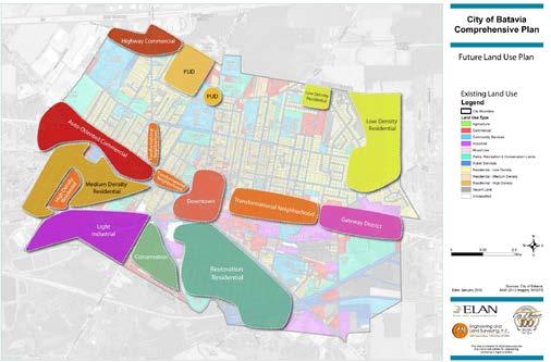
In addition to these goals and recommendations, the Comprehensive Plan includes a Future Land Use Map and definitions of land use categories for which it would like to see implemented in the future.
Each of the sections of the Zoning Code has been reviewed in light of the above goals and recommendations and the future land use categories in the Plan. The considerations in this report are made in light of advancing all of the items that can be influenced by the content of the Zoning Code. The following code analysis identifies a broad array of suggestions to allow these recommendations to be realized.
Figure 1 - Future Land Use Map
Zoning Code Analysis
Decisions on the scope and content of revisions are ultimately that of the City Council and the electorate. The considerations written here are subject to change as the project progresses. We present this report as a means of engaging the community to gather input and develop meaningful and desirable revisions to the Zoning Code.
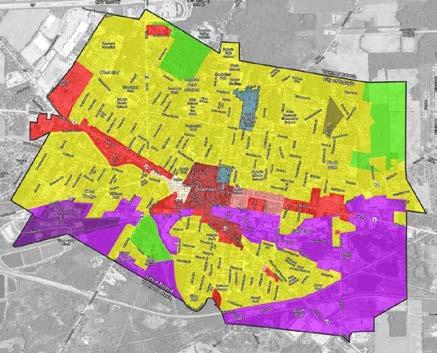
Figure 1 - Existing Zoning Map
Zoning Map
The overarching goal of this Zoning Code rewrite project is to craft custom-tailored, clear, consistent, user-friendly, resilient, equitable, and defensible zoning regulations that advance the City’s quality-of-life vision. The new code should be streamlined, more userfriendly, and more effective at achieving the City’s desired outcomes. Batavia is not a onesize-fits-all community, and its zoning regulations should not be one size fits all.
Code Snapshot
Although the history of the City dates back to its founding in 1802, the first Zoning Code was not adopted until 1981. Since adoption, the Zoning Code has been amended 28 times affecting approximately half of the sections in the code. As a result, portions of the code are more up to date than others, almost half of the code remains as written over 40 years ago. This piecemeal approach to updates is usually a reaction to a zoning code that is not comprehensively keeping up with an evolving community.
Ch. 190 “Zoning” contains eleven (11) articles:
Articles I - Title
Articles II – Establishment of Districts
Articles III – Residential Districts
Article IV – Commercial Districts
Article V - Industrial Districts
Article VI – Adult Uses
Article VII – Special Districts
Article VIII – Area, Yard and Height Regulations
Article IX – Supplementary Regulations
Article X – Administration
Article XI – Amendments and Penalties
The Zoning Code has been regularly updated to address the land use issues of the day, which has created a set of regulations that do not reflect a cohesive and consistent vision for the City. The Zoning Code should be written so that it proactively promotes the community’s vision. For example, setting forth a clear vision for the size, scale, massing, and location of all structures should be as important, and in some instances, more important than their function.
The Zoning Code is decidedly outdated in key areas that adversely affect the usability, clarity, and overall effectiveness of the regulations. Some examples include antiquated definitions and a lack of graphics or tables to help convey complex concepts. It also uses an Appendix (Schedule I) for the bulk standards, which if integrated into the code would make it easier to use and administer. The Zoning Code should be read as a cohesive set of regulations promoting a commonly understood vision.
Analysis and Considerations
Article I – General Provisions
Article I primarily includes the Title, Purposes and Definitions of the Zoning Code. This section should introduce the ordinance and outline how to use and interpret the Zoning Code. Ideally, it would provide a clear explanation of how the Zoning Code is connected to the Comprehensive Plan and the vision of the community. This Article should also explain the intent and applicability of the document. Please see the following considerations:
Considerations:
• Include “how to” provisions at the beginning of the code in a “Introduction and How to Use This Code” section. Modern zoning codes typically locate the administration, procedures, and glossary sections toward the end of the code to focus the reader’s attention on answers to the primary questions: what can I do with my property and how can I do it?
• Glossaries/definitions tend to be long and despite previous conventional thinking not introductory or a helpful or an effective way to begin a code. Move the definitions to a comprehensive glossary at the end of the code.
• Update the code’s purpose and intent statements to reflect the Comprehensive Plan goals and objectives. The current purpose language has not been updated since 1981.
• How to measure, interpret language, and how to read the zoning map are essential elements of using the code and should be clearly spelled out with concise wording and graphics/charts.
Article II – Establishment of Districts
This section outlines the zoning districts, the interpretation rules, and how to address a property located in more than one zoning district.
Considerations:
• With the exception of the section that introduces zoning districts, all the content in this Article should be consolidated with Article I to streamline the document and keep related information in one section.
• The Zoning Code contains fourteen districts. For a community of just over five square miles, fourteen districts may be excessive, especially given that some of the
land area of the City which suggests that there are some districts that have very limited applicability or are rarely used. An analysis should occur to determine if it is possible to merge or eliminate some districts.
Article III – Residential Districts
This section contains the list of permitted uses, accessory uses, and uses allowed with a special use permit for all the residential districts contained in the Zoning Code. The City is largely zoned for residential uses – 59% of the City is categorized in one of the four residential zoning districts. Conversely, only 31-32% of the City is utilized for residential purposes; 26% of the City is utilized for low density residential uses, 5% is utilized for medium residential uses, 0.5% is utilized for high density residential uses, and 0.8% is utilized for mixed uses.
Considerations:
• Generally, the text included in this section could be replaced by a comprehensive use table. Rather than listing all uses allowed in each district, a single matrix that identifies if the use is allowed by right or requires a special use permit would replace the existing text. Information for permitted accessory uses could also be combined in a single table.
• Schedule I, which identifies the dimensional standards for all the districts, should be reformatted and added into the code rather than being an Appendix to make the Zoning Code more concise and user friendly.
• The list of permitted uses has several out-of-date terms such as “boardinghouse,” “lodging house,” “tourist home,” etc… A review of existing land uses and definitions would clarify what is allowed in the “R” districts.
• All multi-family buildings (greater than two stories) require a Special Use permit. It is unusual to not have a district where multi-family uses are allowed by right. The City should consider the creation of a zone that allows multi-family uses by right in stand alone and mixed-use contexts.
• Uses three-stories or taller are defined as a “high rise” which is confusing because this definition is typically one connected to the building code. High-rise construction is usually construction of 75 feet or higher, which is significantly higher than three stories. Use of this term should be reconsidered.
• This R-1A district is very similar to the R-2 district. The City should consider combining these two zoning districts for simplification.
Article IV – Commercial Districts
This section contains the list of permitted uses, accessory uses, and uses allowed with a special use permit for all the commercial districts contained in the Zoning Code. Approximately 10% of the City is zoned for commercial uses and 11% of the City is used for commercial purposes.
Considerations:
• As with the Residential Districts, the text included in this article could largely be replaced by a comprehensive use table. Rather than listing all uses allowed in each district, a single matrix that identifies if the use is allowed by right or requires a special use permit would replace the existing text. Information for permitted accessory uses could also be combined in a single table.
• Schedule I, which identifies the dimensional standards for all the districts should be reformatted and added into the code rather than being an Appendix to make the Zoning Code more user friendly.
• All development activity in this district requires Site Plan Review (process is outlined in Article IX).
• The C-3 District contains an extensive set of design guidelines. A goal of the Comprehensive Plan is to add form-based concepts into the Zoning Code. Expansion of the design guidelines beyond the C-3 District would help address this goal.
Article V – Industrial Districts
This section contains the list of permitted uses, accessory uses and uses allowed with a special use permit for all the industrial districts contained in the Zoning Code. Approximately 20% of the City is zoned for industrial uses while only 5% of the City is used for industrial purposes.
Considerations:
• As with the residential and commercial districts, the text included in this article could largely be replaced by a comprehensive use table. Rather than listing all uses allowed in each district, a single matrix that identifies if the use is allowed by right or requires a special use permit would replace the existing text. Information for permitted accessory uses could also be combined in a single table.
• Schedule I, which identifies the dimensional standards for all the districts should be reformatted and added into the code rather than being an Appendix to make the Zoning Code more user friendly.
• All development activity in this district requires Site Plan Review (process is outlined in Article IX). For a discussion of comparing land use statistics of a community, see https://www.planning.org/pas/reports/report14/. For a discussion of comparing land use statistics of a community, see https://www.planning.org/pas/reports/report14/.
Article VI – Adult Uses
This section establishes rules for adult uses to address the negative effects such uses can have on surrounding properties especially when concentrated with other such uses. The language in this section was first adopted in 1994 and it has been updated twice, last in 2001 when definitions were modified.
Considerations:
• Given that these regulations have not been update for over 20 years, it may be appropriate to subject these to a review by the City’s legal counsel.
• In the rewrite, this section should be moved to the Supplemental Use area of the code which contains standards for other singular uses that have specific rules or development standards.
Article VII – Special Districts
This section establishes the regulations for all special districts. These districts include Land Conservation, Planned Developments and the Historic Overlay districts.
There are 1,113 acres of FEMA flood zones within the City of Batavia, equating to approximately 20% of the City’s land area. Of the 1,113 acres, 68% are part of the designated 100 year flood zone, and 32% are part of the 500 year flood zone. A 2013 GIS analysis revealed that 1,030 single and two-family homes are located within the 100-year floodplain. Despite nearly 20% of the City located in the floodplain, only 7% of the City is zoned for land conservation.
The approach to Planned Development Districts (PDDs) is uncommon in that the standards included in the approved are codified into the Zoning Code. Additionally, unlike other zoning districts, the boundaries of the PDD are also described in the Zoning Code. The current regulations indicate that any change to the PDD requires a public hearing and review by the City Council.
Considerations:
• Given the breadth of the floodplain area, an evaluation should occur to determine if the Land Conservation District is the most effective way to address properties located in the floodplain. Perhaps this district should be reserved for other conservation areas not located in a floodplain.
• At a minimum the Land Conservation District should contain storm water management regulations in addition to restrictions for construction methods, materials, and locations as a means of reducing damage to investments in the event of flooding. This district may be best implemented as an overlay zone to enable development patterns to be consistent with the vision in the Comprehensive Plan but subjected to common flood hazard regulations.
• Currently, it appears that any change to an approved PDD requires legislative review without any discretion given to the planning staff or Planning Board. Most communities establish thresholds that allow the staff or Planning Board to grant minor changes to a PDD without requiring public notice and reserves legislative review only for major changes. The City should consider establishing standards that define minor and major modifications to a PDD and identifies the appropriate process for reviewing such requests.
Article VIII – Area, Yard and Height Regulations
This section contains standards for area, yard, height and coverage restrictions including a few specific standards for how to treat existing lots and making modifications/reductions. It also contains customary language regarding yard exceptions and allowable projections.
Considerations:
• This section is largely unnecessary as it requires compliance with Schedule I, which should be put into the text of the Zoning Code to be more user friendly.
• The section regarding “Existing Lots (§190-31) contains confusing text because single family homes are permitted in several districts with different minimum lots sizes. This language needs clarification.
• Yard Regulations §190-33-E should be revised to reference “Clear Sight Triangle” and a diagram should be added to make it easier to understand the application of this section.
• Diagrams should be added to this section to clarify how to interpret yard locations, height, etc.
Article IX – Supplementary Regulations
This article contains Supplementary regulations, more commonly called “Generally Applicable” standards. It contains regulations for landscaping/buffering, accessory uses, nonconforming uses, special use permits, parking, signage, and several other miscellaneous regulations in addition to the standards for site plan review.
Considerations:
• The definitions in the landscaping/buffering section should be moved to the general definitions section. There is information in the section that would be better displayed in a Table. Additional Figures should be added to better illustrate landscaping requirements.
• Landscaping regulations should be updated to include a native species and prohibited species list and should include pervious surface requirements and limits on new impervious surfaces to address the impacts of development on stormwater runoff.
• The section regarding accessory uses could be eliminated or greatly streamlined by adding accessory use permissions into a comprehensive use table with all the other district permissions. Additionally, the specific standards for parking of motor vehicles, swimming pools, etc. could be moved to a new section titled “Specific Use Standards”.
• Many customary uses are only allowed through a Special Use Permit. With site plan review being required for most uses, the City should evaluate if it is duplicative to require common uses to be subject to the Special Use Permit process as well. Such an approach would allow uses in alignment with the goals of the Comprehensive Plan to be easier to establish.
• The signage regulations were updated in 2019 and appear to be compliant with the content neutral standards required by the United States Supreme Court’s decision in Reed v. Gilbert. This section contains sign diagrams; however, this section could be reorganized to present the information in an easier to read format.
• The Miscellaneous Regulations section contains rules regarding disparate matters. As part of a code reorganization, these items should be moved to the appropriate section of the revised Zoning Code.
• The City should consider moving the Site Plan Review process to the section of the code containing the other administrative procedures. At present, it is the only regulatory process contained in this Article.
Article X – Administration
This section outlines the role of the Code Enforcement Officer, the process for obtaining a permit, and the role of the Board of Zoning Appeals including the standards for reviewing area and use variances.
Considerations:
• The administrative section could be improved and clarified for ease of use, streamlining, and administration.
• The bulk of the language in this Section dates to the original adoption of the Zoning Code in 1981. It may be appropriate to perform a legal review of this section to assure language and standards are up to date.
Article XI – Amendments and Penalties
This section contains the standards for penalties, information about zoning amendments, performance bond standards and interpretation rules.
Considerations:
• This section contains an odd mix of standards. In the rewrite of the Zoning Code, these items should be moved to the appropriate section of the code.
• Consider having all processes in the same Article (Amendments, Variances, Appeals, Special Uses, etc.)
• Include tables and graphics to organize procedures where appropriate. For example, a comprehensive procedures summary table is helpful for the user and administrator.
Improvements Necessary to Support Comprehensive Plan
The following provides a regulatory environment that supports the development patterns identified in the Comprehensive Plan. Several suggestions address ways to improve development patterns along commercial corridors while other suggestions address housing development.
Future Land Use. The Future Land Use Map included in the Comprehensive Plan should form the foundation of the changes to the Zoning Code. To achieve the future identified in the Comprehensive Plan, zoning districts and corresponding development standards need to be designed to assure that these desires are achieved. A review of all the existing districts against the future land use definitions should be undertaken.
For areas such as “Downtown” and “Transformational Neighborhood” where there are specific design considerations in addition to allowing a mix of uses, the code will need to be revised to allow for flexibility while establishing guardrails to assure compatibility with existing and surrounding uses. Diagrams and schematics will be essential to inform the Planning Board and property owners/developers to make it clear what the expectations are for these areas.
A great deal of study will be required to achieve the vision included in the “Restoration Residential” areas of the City. The Comprehensive Plan indicates that the City must “Reimagine the areas of the City that lie within the 100- and 500-year floodplains.” Finding a way to enhance residential uses located within the floodplain in light of the likelihood of future flooding will require a great deal of consideration. An obvious goal is to enhance existing uses while balancing against changes needed for more resilient building standards.
Commercial Corridors. The Comprehensive Plan places a strong emphasis on improving the form of new buildings along commercial corridors. To this end, the City should consider including design typologies with accompanying development standards in the Zoning Code. Outside of the regulations for the downtown contained in the C-3 District, it appears that decisions regarding building massing, scale, setback, etc. are dictated by the dimensional and yard standards contained in Schedule I and direction from the Planning and Development Committee required as part of the Site Plan Review process. The current approach should be reconsidered for an approach that is more consistent and predictable for both the City staff and property owners.
Use permissions. Currently, parking lots can be constructed as a primary use if approved as by Special Use permit. Parking lots do not serve as destinations for vibrant, walkable communities. Parking lots should only be allowed as accessory uses to businesses, institutions, and dwellings, thereby reducing the likelihood that valuable commercial land is used passively for temporary automobile storage. Consider removing parking lots as a permissible Special Use.
Dimensional standards. In areas where the Comprehensive Plan prescribes stronger design considerations, especially in the Commercial districts, consider implementing a maximum permitted setback from a public right-of-way to establish a consistent street wall. A maximum setback in coordination with street frontage activation standards will help emphasize pedestrian connections along the public right-of-way.
Parking standards.
• Consider prohibiting parking between any buildings and the public right of way. Doing so will maintain the emphasis on walkability and pedestrian connections to active uses and destinations.
• Consider incentivizing and supporting shared parking agreements for parking lots.
• Consider establishing parking maximums to avoid the construction of more parking than is necessary. This can help conserve land as well as avoid large expanses of unused paved surfaces.
• Many communities are choosing to eliminate parking minimums altogether. Others are putting the responsibility in the hands of property owners to prepare a parking analysis to verify their parking needs instead of the municipality determining the minimum requirements. It is difficult to know whether the current off-street parking standards are adequate without undertaking a comprehensive parking demand study. Like most places, parking may be at a premium at certain times and readily available at others, depending on the location with the City. If parking minimums are desired, improvements the parking requirements with tables and diagrams could make the standards more user friendly.
Bicycle Parking. The Comprehensive Plan identifies the desire to put a stronger focus on bicycling infrastructure. If standard parking minimums are kept, the City should consider modifying the code to allow for a reduction in spaces when bicycle parking facilities are provided. If parking minimums are eliminated, the code should still require businesses to provide bicycle parking as a way to promote cycling as an alternative to driving. At a minimum, bike parking facilities (i.e. racks) should be provided as part of future commercial development approvals.
Tree Management. The Comprehensive Plan indicates that the City should “Manage trees as an important part of the urban environment.” At present, it does not appear that the Zoning Code contains standards for tree management or protection. The City should consider adding standards to limit unnecessary tree removal which can be achieved through various approaches. Standards that require an arborist report accompany any tree removal to determine the health of the tree and the reason for the removal, can be required. Alternatively, tree replacement could be required for any trees that are removed as part of a development expansion or new project. Credits can be given for existing trees to incentivize modification of a site plan to keep trees rather than removing mature trees and replacing them with smaller/younger ones.
Accessory dwelling units (ADUs). The Comprehensive Plan recommends investments in housing that includes a diverse range of housing types, including low income, workforce and market rate seamlessly integrated across the City.
ADUs can take many forms but are, in essence, an individual dwelling unit located on the same property as a primary dwelling. An ADU can be attached to the primary dwelling as part of an addition, detached from a house in an accessory structure (including above a detached garage), located in an upper floor of a primary dwelling, or located in an accessible basement that provides proper ingress, egress, light, and air.
ADUs in any form can make multi-generational households more comfortable – providing space and independence for in-laws, and easier access to childcare for parents. ADUs can bring an additional source of income that provides important flexibility (or survival) for a household’s budget. And where individual property owners may choose to construct an ADU, they also end up providing different housing options that can meet the needs of a diverse range of households. For example, a single-person household may not desire to own a house or rent an apartment, but still wish to be close to a job opportunity in Batavia. Renting an ADU can be mutually beneficial, especially where the owner is aging and finds that retirement and/or social security benefits are not keeping up with rising costs; or where the owner is having difficulty affording childcare.
Currently, the Zoning Code allows for accessory dwelling units (ADUs) by Special Use Permit. There is a growing trend across the country to allow ADUs by right rather than requiring a public review process. Given the increasing cost of housing and the lack of available housing, the City should consider permitting ADUs by right as an accessory use to primary dwellings on lots that meet dimensional requirements and the standards established by the City.
Currently, the Zoning Code allows for accessory dwelling units (ADUs) by Special Use Permit. There is a growing trend across the country to allow ADUs by right rather than requiring a public review process. Given the increasing cost of housing and the lack of available housing, the City should consider permitting ADUs by right as an accessory use to primary dwellings on lots that meet dimensional requirements and the standards established by the City.

Residential District Lot Sizes. The minimum lots sizes that exist in the Code were established in 1981 when zoning regulations were first adopted. Most of the homes in the City pre-date the existence of zoning regulations. Schedule I (appendix to Zoning Code) indicates that the minimum yard requirements only apply to new construction. Given that the Comprehensive Plan calls for a diversity in housing, establishing standards that allow for infill development to occur should be considered. The City should inventory existing lot sizes and zoning districts establish lot sizes and setbacks that allow for infill construction to match existing development patterns. If larger lots are desired in new developments, then a separate district may need to be added to the Zoning Code.
Figure 3 - Example ADU Arrangements (illustrated by the American Planning Association)
Missing Concepts
The following analysis identifies major concepts or ideas that are absent in the current Zoning Code. These topics are not covered in the definitions or regulations and should be given consideration for inclusion in the rewrite of the Zoning Code.
Adult Use of Marijuana/Cannabis. As the roll-out of adult-use marijuana continues in New York, the City should define this use and determine where such uses are allowed. State law prohibits cities from banning these uses, but like any other use, the Zoning Code should clarify where such uses are permitted.
Alternative/Passive Energy Regulations. There is no mention of wind turbines or solar panels/facilities in the existing Zoning Code. Given the focus on resiliency and renewable energy in the Comprehensive Plan, the use of wind turbines and solar panels for on-site energy production should be considered. Regulations that address the siting, design, operation, and similar aspects of wind energy turbines, solar panels/facilities and other passive energy collection systems should be added to the Zoning Code to enable greater energy capture potential for properties in and near the City.
Electric Charging Stations. Whether in a group or stand-alone, electrical charging stations will continue to be in demand as electric car usage increases. The current Zoning Code is silent on such uses. Regulations that require their approval using the least intrusive and best-camouflaged means possible when they may be visible from the street should be considered.
Outdoor Lighting. The Zoning Code does not contain standards for outdoor lighting. Considerations for minimum and maximum lighting standards should be added. These standards should incorporate the most recent technology standards to avoid unnecessary light pollution.
Short Term Rentals. It does not appear that the City regulates short-term rentals. At a minimum, this use should be defined and added to the Zoning Code. If limitations for such uses are desired, they should also be incorporated into the code.
Telecommunication Towers. Consider adding definitions and regulations for telecommunication towers. The City does not define large or small cell telecommunication uses in the Zoning Code nor does it have regulations to clarify where they are permitted. Given the growing reliance on mobile communications, standards to regulate these facilities should be created.
Temporary Uses. Consider adding definitions and regulations for temporary uses. The current Zoning Code does not mention temporary uses such as garage/yard cells, festivals, short-term promotional events, etc. These uses should be defined, and regulations or clarifications added to understand how such events are regulated.
Urban Agriculture. Consider allowing for limited bee/chicken keeping and not limiting where residents can grow vegetables. Increasingly, urban residents are choosing more sustainable access to food and want to grow vegetables, keep bees, and raise chickens. Allowing such uses with minimal limitations should be considered.
Ineffective or Flawed Items
The following analysis identifies specific items or elements in the Zoning Code that are ineffective, flawed, or need to be addressed in some way.
Comprehensive Use Table. Consider building a comprehensive principal use permissions table that shows in one place all the permitted principal uses across each district.
Residential Zones Use Permissions
Figure 4 - Example Comprehensive Use Permissions Table
● = Allowed with Permit
◑ = Conditionally Allowed
= Allowed as Accessory Use
Where the Zoning Code includes lists of permissions within each district, a comprehensive table provides one consistent reference point for all use permissions – making administration more efficient and interpretation more consistent. Such a table would combine the information for uses requiring Special Use Permits as well as those permitted by-right. Consider having an excerpt table within sections of the code for each district that defers to the comprehensive table. This approach (a comprehensive table with excerpts) organizes the information to provide a user-friendly experience for two different perspectives of users: current property owners looking to improve or expand their building or potential developers looking to invest for the first time in the City of Batavia.
Definitions. A wholesale review of this section should occur as there are numerous definitions that should be added. There are no definitions for passive energy collection systems, electric charging stations, multi-modal pathways, and several other key items that are called out in the Comprehensive Plan. It would be beneficial to introduce definitions related to these elements to allow for clear regulations.
District Descriptions. The districts lack purpose statements which can be helpful to describe the intent of the district. Additionally, in some cases, the regulations are overly complex and could be simplified by the introduction of a central Use Table and the introduction of graphic standards to indicate yard and bulk limitations.
Planning Board v. Planning and Development Committee. The Zoning Code refers to both the Planning Board and the Planning and Development Committee in different parts of the code. It is unclear if these are separate groups or one in the same. Without the responsibilities of the Planning Board and/or the Planning and Development Committee identified within the context of the zoning regulations, it is unclear who does what. While these roles are identified in other parts of the codified ordinances, it is not likely a user of the code would go outside the Zoning Code to review roles/responsibilities of any given board or committee. In essence, this arrangement is not user friendly. The City should consider clarification of the roles and responsibilities of these two groups (if indeed they are two different groups) and identify their duties within the Zoning Code .
Parking Requirements. Unless the City decides to eliminate parking minimums as discussed earlier in this document, a simpler approach like the example provided below should be considered. This approach reduces parking requirements and preserves property for development rather than building parking lots that are larger than necessary.
Notes: A unit is a residential dwelling, not the number of bedrooms within a residential dwelling.
Supplemental Standards. Article IX, in general, should be updated to include many additional, supplemental standards commonly found in modern zoning regulations. A wholesale review and update to this portion of the Zoning Code is recommended.
Subdivision Regulations. Consider reviewing the current Subdivision Regulations to determine if the design standards are appropriate to achieve the desired outcome identified in the Comprehensive Plan. Typically, most cities have adopted subdivision regulations that are more appropriate for a suburban development pattern and may not be able to address the development pattern desired in the older parts of the City.
Figure 5 - Example Parking Requirement Table
Conclusion
The ideas presented above highlight potential adjustments that will simplify zoning processes and remove barriers for desired investments and development. These suggestions include developing comprehensive tables, consolidating uses into categories, improving organization, and updating illustrations. Collectively, these recommended changes will help property owners navigate the Zoning Code and produce better outcomes in the built environment of the City of Batavia.
In summary, the existing Zoning Code has been piecemeal updated since 1981 to address the zoning and development issues of the day. While some more recent updates have been made to address more recent issues, the piecemeal nature of the revisions to date has created a disjointed code with inconsistencies and ambiguities that does not portray a unified or clear vision for the City. The code lacks tables to organize lists such as uses. It also lacks illustrations and graphics to explain complex concepts more simply.
Every provision in the new Zoning Code should promote one or more of the Comprehensive Plan Goals or Recommendations. A new Zoning Code should be simplified to reflect the relatively small size of the City and its current development patterns. Furthermore, the new code should focus on desired outcomes relative to new construction, additions, and infill development. The code could be further streamlined by combining certain existing districts.
As this report details, there is much that can be done to establish clear, consistent, userfriendly, streamlined, resilient, and defensible land use regulations that are custom tailored to the Batavia of today and tomorrow.
Proposed Table of Contents
The following is an example of how the City’s updated Zoning Code could take shape. This is intended to be illustrative and is for discussion purposes only.
Article 1. Introduction to and How to Use the Code
1.01 Authority and Title
1.02 Minimum Requirements and Relationship Between Provisions
1.03 Purpose and Intent
1.04 Comprehensive Plan
1.05 Zones, Districts, and Overlays Established
1.06 Zoning Map
1.07 Rules for Interpreting Zoning Boundaries on the Zoning Map
1.08 Severability and Repeal
1.09 Rules of Measurements and Calculation
1.10 Permitted Encroachments into Required Setbacks
1.11 Rules of Interpretation
1.12 How to Use this Code
Article 2. Zones, Districts and Subdistricts
2.01 Introduction
2.02 Districts
2.03 Overlay Districts
Each of the above Districts and Zones will include the following:
Purpose and Intent
Permitted and Special Uses
Lot and Setbacks
Building and Design Standards
Article 3. Supplemental Use Standards
3.01 Purpose and Applicability
3.02 Accessory Dwelling Units (ADU)
3.03 Childcare
3.04 Telecommunications Towers and Facilities
3.05 Electric Charging Stations
3.06 On-site Energy Production (Wind/Solar)
3.07 Home Occupations
3.08 Bed and Breakfasts and Short-term Rentals
3.09 Adult Entertainment Uses
3.10 Private Swimming Pools and Community or Club Swimming Pools
3.11 Portable Storage Units
3.12 Private Non-Commercial Garages
3.13 Temporary Uses
3.14 Temporary Construction-Related Structures
3.15 Adult Use Marijuana
Article 4. Generally Applicable Regulations
4.01 Performance Standards
4.02 Accessory Uses and Structures
4.03 Lighting
4.04 Landscaping, Screening and Buffering
Purpose and Applicability
Landscape Plan Requirements
Tree Preservation
Street Tree Requirements
Perimeter Landscape Requirements
Bufferyard Requirements
Landscape Materials
Screening in Commercial or Industrial Districts
4.05 Parking and Loading
Purpose and Applicability
Minimum Parking Space Schedule
Reductions to Minimum Parking Space Schedule
Minimum Parking Space Dimensions
Pick-Up and Drop-Off Parking Spaces
Shared Parking Spaces
Location of Parking Areas
Bicycle Parking
Pedestrian Walkways in Parking Areas
Parking Area Surfaces
ADA Parking Requirements
Parking Lot Landscaping
Drive-Through Standards
Loading Standards
4.06 Signage
Purpose and Scope
Signs Permitted in all Zones
Prohibited Signs and Sign Elements
Regulations Applicable to all Sign
Sign Standards by Zone
Special Use Signs
Nonconforming Signs
Off-Premises Signs
Article 5. Administration and Procedures
5.01 Code Enforcement Officer
5.02 Board of Zoning Appeals
5.03 Planning and Development Committee
5.04 Zoning Permits and Applications
5.05 Appeals of Administrative Decisions
5.06 Variance Permits and Applications
5.07 Special Use Permits and Applications
5.08 Substantially Similar Uses
5.09 Zoning Map Amendments
5.10 Zoning Text Amendments
Article 6. Nonconformities
6.01 Continuance or Discontinuance
6.02 Determination of Vacancy or Abandonment
6.03 Restoration
6.04 Expansion or Substitution
6.05 Improvement on a Nonconforming Lot
6.06 Elimination of Nonconforming Status
Article 7. Enforcement
7.01 Violations
7.02 Remedies
7.03 Penalty
Article 8. Glossary of Terms
(All definitions in this Article)