


Zoning significantly affects where people can or cannot live, purchase goods, own land, start businesses, raise children, age in place, find employment, and seek education, among other pursuits of happiness. Zoning regulations impact many aspects of a city, including the natural environment, housing availability, the feel of a neighborhood, access to greenspace, health and walkability, entrepreneurial opportunities, and economic stability. Therefore, an effective and efficient zoning code is paramount to achieving a community’s desired outcomes.
This report evaluates the efficiencies and deficiencies of the current Zoning Code in its ability to achievethecommunity’sobjectivesasstatedinthe We Make U City Comprehensive Plan,or“the Comprehensive Plan,” as well as modern planning best practices.
This report was produced by a team of planning professionals that relied on the Comprehensive Plan, professional expertise in the planning discipline, and familiarity with the national best practices. However, it is important to note that this analysis is not scientific or absolute. Revising a zoning code to better align it with a community’s vision and desired outcomes is an iterative process among residents, officials, and aconsultant team.
This report is the beginning not the end of the discussion. It is intended to start the conversation in earnest by recognizing where the current land use regulatory scheme falls short of achieving thegoalssetforthbytheComprehensivePlan.Anysuggestedconsiderationswillbethefocusof robust policy discussions in the future, but ultimately, decisions on the scope and content of revisions are that of the community. The considerations in this report are subject to change as the Zoning Code rewriteproject evolves.
How to use this document.
Thisreportaimstosetaclear visionfortheupcomingZoningCoderewriteprojectbyhighlighting wherethecurrentcodepromotesorpreventsdesireddevelopmentoutcomes.Toaccomplishthis, this document starts by establishing a history of planning directives in University City country before exploring various regulatory approaches and tools that can be used to achieve these planninggoals.Then,thisdocumentpresentstheshortcomingsofthecurrentcodeandsuggests solutions to solving those problems. The report accomplishes this by examining each section of the current code against the land use objectives established in the Comprehensive Plan as well as a set of modern zoning principles established by the consultant team. Where issues with the current code arerecognized, a problem is described with one or more solutions being presented below. This structure takes the form shownin the simple problem below:
1.A. Edward’s shoelaces come undone whilewalking and running. EverytimeEdwardleaveshishouse,hisshoelacescomeundone,requiringhimtospend considerable time re-tying them. This annoys his friend, Lewis, and presents a problem for their friendship. Currently, Edward ties his shoes with one knot. If Edward does not figure out a better way totie his shoes, he will lose his friendship with Lewis.
1.A.1. Edward should use adouble-knot method to tie his shoes.
Double-knotting one’s shoes is a widely-accepted method for ensuring that one’s shoes become untied less often. As opposed to single-knotting, double-knotting provides an extra layer of protection against untied shoes by utilizing two knots instead of just one.
In1902,EdwardGardnerLewispurchased85acresoflandjustoutsidethecitylimitsofSt.Louis, Missourifortheconstructionofhiscompany’snewheadquartersandestablishmentofanewcity. Incorporatedfour years later onthe sameland, University City, alsoknown as“U. City,” is one of St. Louis’ oldest suburbs and, as such, hosts a complex history of zoning and land use that continue toimpact the City’s character.
When Lewis broke ground on the City, he envisioned a model city inspired by the City Beautiful movement that aimed to introduce beautification and monumental grandeur into American cities. As a result, the first planning efforts in U. City established Delmar Boulevard as a grand commercial corridor complete with notable architecture including an Egyptian temple, Art Academy, and the Lion Gates.
Inthedecadesthatfollowed,U.Citygrewinatraditionaldevelopmentpatternthroughthecreation ofsubdivisionsanddevelopmentofamixofhousingtypes.Intheseyears,localzoningseparated residential and commercial uses to create single-use districts. Unlike many American suburbs, however, U. City restrained the use of bulldozers in favor of respecting natural contours in residential areas, making housing more attractive and stable than elsewhere. This strategy worked. On the eve of the Great Depression, the City boasted a population of over 25,000.
While development stalled during theGreat Depression and Second WorldWar, U. City boomed between1945and1960,reachingitscurrentsizeof5.8squaremilesin1960.Duringtheseyears, the City also began to address historic planning inequities that had promoted racial segregation in the early years. Inthe 1960s, City leaders decided tomake integration a top priority as African Americans moved to the suburb in response to being displaced by urban renewal projects in St. Louis. The City approved the University City Home Rental Trust in 1968 to try to maintain integration despite whiteresidents fleeing tonewer suburbs as aresult of shifting demographics. The rental trust had a lasting, if limited, success in keeping certain neighborhoods integrated through 1990, when the trust dissolved.
However, these City did little to address historic discriminatory practices in the region that contributed to contrasting cultural practices, socioeconomic levels, and public policies along the “Delmar Divide.” As a result, significant differences in racial populations persist between the northern and southern parts of the city.
Since 1999, University City has undertaken several planning initiatives toaddress these disparities and improve quality of life for all residents. Today, the city is focused on addressing modern urban challenges such as housing density, transportation infrastructure, economic development, and environmental sustainability through the creation of a new, forward-looking zoning code. These efforts mark acontinued commitment toshaping a more inclusive and resilient community.
Adopted in 2024, The We Make U City Comprehensive Plan is intended to guide the University City’s development and address longstanding challenges. Developed over 18 months with extensive community engagement, key components of the plan include strategies to rectify the impacts of historic segregation by promoting equitable access to housing and amenities, recommendations tomitigate environmentalrisksinflood-proneareas,andinitiativestoleverage regionaltrendsforeconomicandcommunitydevelopment.Belowarethemaingoalsestablished in the plan that will serve as the basis for the observations made in this report.
2.A. Preserve and enhance great places.
Maintain existing character while encouraging creation development, and building resilient, vibrant places.
2.B. Advance shared prosperity.
Support and expand a diverse local economy, quality education, and a strong workforce that improves opportunities for allresidents.
2.C. Connect community.
Investincommunityconnectiontoincreasemobilityoptions,improvesocialcohesion,and encourage civic involvement.
2.D. Leverage assets.
Capitalize on University City’s diverse cultural, historical, and physical assets while investing in new amenities.
2.E. Strengthen livability.
Enhance neighborhoods as the building block of the community and center of day-to-day life and provide community members with choicein where they live in the city.
2.F. Improve collaboration.
Prioritize commitment to action through response governance and strategic partnerships to realize the community’s vision.
The City and region have also undertaken other significant planning efforts in the last 25 years. These plans each contributed to the development of the Comprehensive Plan and remain important documents guiding the future of University City.
2.G. North Central Neighborhood Plan (2002)
In 2002, to meet the goals of the 1999 Comprehensive Plan, University City analyzed specific neighborhoods throughout the city. The North Central Neighborhood Plan identifiedsixkeyconcernsfromresidents:streetupkeep,noiselevels,howlandwasused onOlive Boulevard, trash andillegal dumping,trafficflow,andthecondition of properties.
2.H. Northeast Neighborhood Plan (2002)
In 2002, to meet the goals of the 1999 Comprehensive Plan, University City analyzed specificneighborhoodsthroughoutthecity.TheNortheastNeighborhoodPlanfocusedon five main issues identified by residents: investment in the area, the quality of housing, public infrastructure, the neighborhood's overall feel and appearance, and public safety.
2.I. Northwest Neighborhood Plan (2004)
In 2004, to meet the goals of the 1999 Comprehensive Plan, University City analyzed specific neighborhoods throughout the city. The Northwest neighborhood highlighted seven priority areas for residents: housing, how the neighborhood looks, public facilities and services, public health, noise and nuisances,public safety, and communication.
2.J. Centennial Greenway Plan (2006)
The2006CentennialGreenwayPlanwasaregionalefforttoconnectparksinandaround St. Louis. This greenway goes through UniversityCity, withthe plan emphasizing Delmar Boulevard and the Loopas popular destinations for people using the greenway.
2.K. Parks Master Plan (2008)
The 2008 Parks Master Plan reviewed existing parks and evaluated their performance againstnationalstandards.Residentswerealsosurveyedabouttheirparkvisitsandideas for improvements to helpset goals and priorities for the park system.
2.L. Urban Forestry Strategic Plan (2009)
This plan reviewed UniversityCity'sexistingrulesand plansrelatedtoits trees and green spaces. It established a vision, goals, and recommendations for the best way to manage the city's urban forest, expanding on the work of the annual Community Forestry Plan.
2.M. SustainabilityStrategic Plan (2011)
Created in 2011 by the University City Green Practices Commission, this plan set goals andactionstointegratesustainabilityintothecity'soperationsandprograms.Thesegoals are organized into seven areas: ecosystems and habitats, water and stormwater management, air quality and transportation, water and resource conservation, land use, open spaces, and parks, energy use, and green building practices.
2.N. Delmar Loop Area Retail Plan & DevelopmentStrategy (2011)
Funded by Washington University and developed with University City staff and local businesses, this 2011 plan detailed strategies to revitalize the Delmar Loop area after a decline in popularity in the late 2000s. Proposed actions included more residential buildings, dense mixed-use developments, and areas with a focus on transit-oriented development.
2.O. Bicycle and Pedestrian Master Plan (2013)
The 2013 University City Bicycle and Pedestrian Plan outlined projects to improve infrastructure,policies,andinitiativestoincreaseaccesstosafewalkingandbikingroutes. The plan aimed to create fair access to transportation options for everyone in University City.
2.P. Olive Boulevard Design Guidelines (2009)
The 2009Olive Boulevard DesignGuidelines aimto encourageeconomic growth, protect historic buildings, and make meaningful improvements to the street. The guidelines provide a framework for how streets should look, what types of buildings are appropriate, signage, and landscaping, among other elements.
2.Q. Sustainable Development Guidelines (2019)
These 2019 guidelines provide a complete list of sustainable building practices, categorized by what the City recommends, encourages with incentives, and requires. These guidelines aregiven todevelopersandareregularlyupdatedwith new sustainable practices that don't hinder construction.
2.R. St. Louis CountyAction Plan for Walking and Biking (2021)
Following the passage of the St. Louis County Complete Streets Ordinance, the County created this 2021 action plan to help achieve the ordinance's goals. The plan guides decisions about infrastructure, programs, and policies related to active transportation like walking and biking.
2.S. Economic Development Strategy (2021)
This 2021 plan aims to create along-term strategy for economic growth inUniversity City followingtheCovid-19pandemic.Theplanoutlineskeyeconomicprinciplesandidentifies ten distinct commercial areas to guide where and how development strategies are implemented. This plan helped start the work for the comprehensive plan by promoting local growth strategies and identifying key areas for development.
2.T. FOR THETHIRD WARD Housing &Revitalization Plan (2024)
Through TaxIncrementFinancing (TIF) fromtheMarket at Olive development, University City will generate $15 million for Third Ward revitalization. The FOR THE THIRD WARD Housing & Revitalization Plan outlines strategies to invest these funds to boost housing values, support economic diversity, promote homeownership, and revitalize the historically overlooked area.
Modern planning best practices.
Strong planning is for naught if a zoning code impedes its own effectiveness. Implementing modernbestzoningpracticesensuresthatanewzoningcodeisfinelytailoredandhasapositive impact on a community, These following is a list of practices that enhance the zoning code by making it mor cohesive, more accessible, more resilient, and less vulnerable to legal conflicts.
2.U. Regulate onlywhen necessary.
Zoning is essential for organized development, butregulationsmust belegally sound and promote legitimate state interests like public health and safety. Overly restrictive can contribute toinequitable development and be overturned.
2.V. Respect developmentpatterns.
Zoning should align with a community's current and future development goals to encourage investment and avoid creating unnecessary hurdles and costs, particularly for lower-income residents.
2.W. Zoning should not be a barrier to the plan.
Zoning should effectively translate a community's vision from its plans into clear and consistent regulations. When zoning is not aligned with long-term planning it can hinder rather than support development goals.
2.X. Promote environmental and social equity.
If done without consideration to the local environmental or social context, zoning can contribute to environmental degradation, segregation, unequal access, and climate change.
2.Y. Codes should be accessible to everyone.
Simplifyingazoningcode’slanguageandstructurecanempowercommunityparticipation in planning, reduce misunderstandings, and promotefair enforcement.
Plan Objective 1: Preserve and enhance great places.
University City has traditionally functioned as a “bedroom community,” with zoning and codes designed around car-dependent suburban living and single-use districts, particularly favoring single-family residential areas. The current zoning framework separates land uses and emphasizes compatibility of use over building form, which limits flexibility in shaping community character and promoting walkability. To meet the goals of the Comprehensive Plan, the new Zoning Code should support more mixed-use development, reduce reliance on cars, and encourage moreinclusive, accessible, and pedestrian-friendly neighborhoods.
3.A. Observation: Unnecessary dimensional and bulk requirements restrict otherwise permissible and desirable development outcomes.
Dimensional standards and bulk requirements are valuable tools in establishing strong community character and promoting preferred development outcomes. Regulations like lot size, setbacks, and building height limit the size and scale of development, ensuring adjacent buildings are compatible. However, each additional standard requires defined measurementsandconsistentenforcement.NotonlyisthisonerousfortheCity,butitcan also make code compliance more challenging. This has not always been the case. Table 3-1: 1926 Zoning Ordinance Development Standards shows the relatively simple constructionofdimensionalstandardsinUniversityCity’soriginal1926ZoningOrdinance. Where the table is left blank, the copy of the ordinance provided to the consultant was unclear. When compared Table 3-2: 2025 Zoning Code Dimensional Standards - SR District – which shows the dimensional standards for just one district, the simpler nature of the 1926 ordinance becomes clear.
Thereareadditionaltakeawaysfromcomparingthe1926ZoningOrdinancetothecurrent Zoning Code. For example, the minimum lot area has increased across the districts. For example, the most restrictive minimum lot area requirement for residential districts in the 1926 Ordinance was 2,000 square feet. In the 2025 Code, the least restrictive minimum lot area requirement for residential districts is 6,000 square feet. Furthermore, the maximum height is lower in the current commercial districts than the “G Commercial District”inthe1926Ordinance.ThedifferencesbetweenthesecodesshowhowUniversity City’s zoning practices have evolved since their inception, suggesting that a more simplified code is possible.
LotArea(min.) 6,000sq.ft.
LotWidth(min.) 50ft.
FrontSetback(min.) 25ft.orprevailingpatternifthereisnoplatted buildingline,whicheverisgreater.
SideSetback(min.) 5ft.
RearSetback(min.) 30ft.
BuildingHeight(max.) 35ft.or3.5stories,whicheverisless.
Public Utilities Facilities
LotArea(min.) Variable.
LotWidth(min.) Variable.
LotArea(min.)
Other Permitted or Conditional Uses
6,000sq.ft.ormoreifrequiredtoprovide adequatespaceforsetbacksandrequiredparking.
LotWidth(min.) 50ft.ormoreifrequiredtoprovideadequatespace forsetbacksandrequiredparking.
FrontSetback(min.) 25ft.orprevailingpatternifthereisnoplatted buildingline,whicheverisgreater.
SideSetback(min.) 5ft.,except15ft.whereasideyardofanondwellinguseabutsaSRorLRDistrict.
RearSetback(min.) 30ft.
BuildingHeight(max.) 35ft.or3.5stories,whicheverisless.
3.A.1. Suggestion: Provide consistent dimensional standards for all uses in each district.
The current Zoning Code provides different dimensional standards for each use permitted in each zoning district. While this approach is context sensitive, it can also lead to situations where the reconfiguration of an existing lot to a different permitted use is impractical. To prevent this undesirable outcome and increase clarity, the new code should replace this format with one set of dimensional standards for each district. Individual requirements for a specific use can then be reduced or increased in the use standards for that use, if necessary.
3.A.2. Suggestion: Regulate maximum building height through feet rather than stories.
IntheSRandLRdistricts,themaximumheightofabuildingis “threeandone-half (3½) stories or thirty-five (35) feet in height, whichever is less.“ (Section 400.160.C.) This requirement is unnecessarily complicated and can be easily reduced tojust 35 feet. Providing simpler standards will allow for the creation of a user-friendly dimensional standards table.
3.A.3. Suggestion: Create a dimensional standards table for each district.
One way to make dimensional standards easier to recognize is to compile these standards into a matrix. When paired with a graphic as shown in Figure 3-1: Dimensional Standards Table Example - Gaithersburg, MD, dimensional standardstables allow for easyreferencetoeachstandardand howthatstandard affects development. Furthermore, the use of tables reduces the code’s dependence on language that is subject to interpretation.
3.B. Observation: Information regarding what constitutes specific uses, where those uses are allowed, andhow they are regulated is difficult to locate.
To establish a balanced and harmonious separation of land uses, the different uses allowedorrestrictedbythecodemustbeeasilydistinguishable,convenientlylocated,and clearly regulated. The current Zoning Code falls short of this goal.
To start, the code currently provides use allowances for each zoning district at the beginningofthedistrict’ssection,wheretheyarelistedone-by-one.Thisapproachcauses the same use to be listed in multiple ways, complicates the code user experience, and hinders the City’s ability to update the code.
Furthermore, use regulations are scattered throughout the code, making it difficult for the codeusertoidentifythestandardsthatapplytotheirdesireduse.Whencodeuserscannot decipher the code, they are forced to hire experts, disregard the code, or opt not to develop. All three options discourage the restoration and evolution of University City’s neighborhoods.
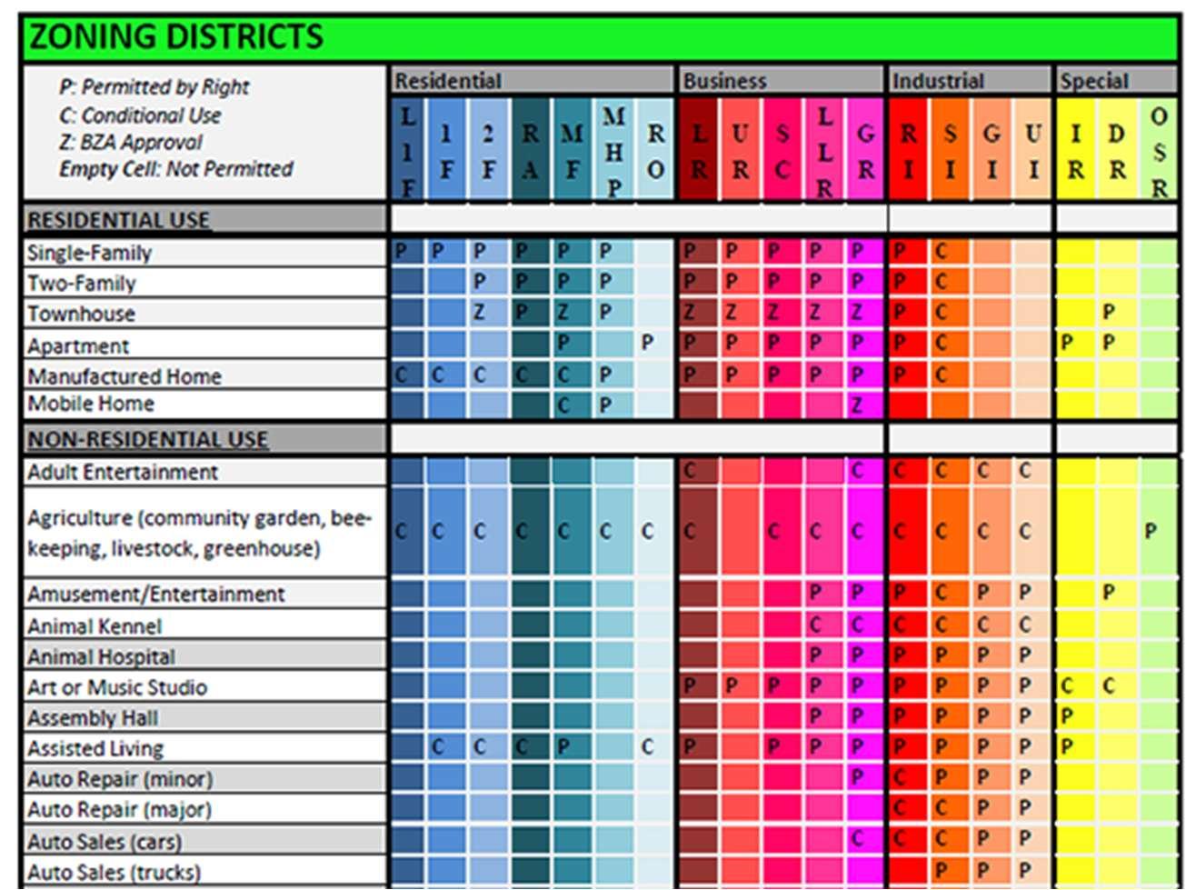
3.B.1. Suggestion: Eliminate listed use allowances by creating a comprehensive use table.
Manycontemporaryzoningcodesincludeacomprehensiveusetablethatconsists of a matrix of all uses identified in the code and all zoning districts. Like many codes of its time, the current Zoning Code does not meet this modern standard. The new Zoning Code should employ a comprehensive use table to display use permissions and orient users towards applicable use standards. Figure 3-2: Comprehensive Use Table Example - Cleveland, OH provides a sample of a comprehensive use table. In providing a similar table, the code can allow a code user to quickly understand where a given use is permitted without reading the entire code.
3.B.2. Suggestion: Convert conditional uses to permitted uses with supplemental use standards.
The current Zoning Code permits some uses by-right and others through the issuance of a conditional use permit. While providing an intermediate use permission between outright prohibition and outright permission, conditional use permits serve an important role. However, conditional use permits can take up to 60 days to review and require approval by the City Council, making their approval lengthy and burdensome. The number of uses permitted by issuance of a conditional use permit could be reduced by permitting more uses by-right subject to supplemental usestandards. The currentZoning Code doesthisfor some uses such as for town-house dwellings and attached single-family dwellings in Section 400.1120andSection400.1125,respectively.Convertingusescurrentlypermitted by issuance of conditional use permit to uses permitted subject to supplemental use standards and consolidating all these standards into one article or division could improvethe code’s accessibility and promote development.
3.B.3. Suggestion: Define all uses and eliminate duplicated terms.
A code is only as strong as its definitions. Even with perfectly tailored use permissions and use standards become difficult to enforce if all uses are not adequately defined. Strong use definitions create clear boundaries between separate uses without creating arbitrary distinctions between uses with similar or identical effects.For example, computer shopsand retailestablishmentscouldbe classified as different uses; however, when considering their effects on the surrounding community, their differences are harder to identify. As such, the new code might opt to include both these uses as “retail establishments” uses. Once these uses are consolidated, the new Zoning Code should define every term in a manner that minimizes confusion and overlap.
3.C. Observation:Restrictinglotstooneprincipaluselimitsopportunitiesformixed-use development.
Currently, all uses in University City are divided into principal and accessory uses with only one principal use being allowed per lot whereas each lot is afforded multiple accessory uses. However, this system prevents mixed-use development and contributes to inefficient land use. While some communities work around this by allowing a use titled “mixed use,” these solutions mostly highlight the arbitrary nature of restricting lots to one use.
3.C.1. Suggestion: Allow multiple principal uses per lot in districts where mixeduse development is desirable.
The new Zoning Code should allow multiple principal uses per lot where mixedusedevelopmentisdeemeddesirable.TheFutureLandUseMapencouragesthis development pattern in the “Activity Center” designation along Kingsland Avenue and the “Community Corridor” designation along Olive Boulevard. These areas can continue to thrive if multiple uses can coexist on one lot. The zoning districts containing the bulk of these areas should provide a strong basis for wheremixeduse development is desirable.
While the median household income in University City is greater than that of the St. Louis Metropolitan Statistical Area and the State of Missouri, income is unevenly distributed. Despite thehighermedianhouseholdincome,UniversityCity’spovertyrateishigherthanitsregionaland state counterparts. Income mapping suggests that economic opportunity unevenly distributed towardsthesouthernhalfoftheCity,reaffirmingtheexistenceofthe“DelmarDivide.”Additionally, analysis of property values in University City reveals a similar trend, with the highest property values concentrated in the First Ward. If the City is to address these disparities, it will need to expand its economy. The Comprehensive Plan reveals that education and health services comprise over 30% of economic activity in the City but is not an industry with major potential for growth. As such, the new Zoning Code must address economic inequality by expanding opportunities for new industries such as retail trade and professional, scientific, and technical services.
3.D. Observation: Allow for greater economic opportunity and housing supply North of Olive Boulevard.
The current zoning allows for few economic opportunities North of Olive Boulevard. Specifically, Sections 400.730-400.770 (SR and MR Districts) – which constitute the majority of parcels North of Olive Boulevard — create barriers to neighborhood-scale economic development in residential areas in the north. This contributes to the widening of the “Delmar Divide” in the City. This divide is characterized by pronounced disparities in income, education, housing, and health outcomes between the predominantly minority communities tothe north and the largely white neighborhoods to the south.
The economic stagnationresulting fromthesezoning constraints contributes to acycle of poverty. With fewer businesses and employment opportunities, residents face higher unemployment rates and lower household incomes. This economic disparity is further reflected in educational outcomes; schools in the northern neighborhoods, funded primarily through local property taxes, receive less funding due to lower property values. Consequently, students have access to fewer resources, leading to lower educational attainment and limited upward mobility.
Moreover, the lack of economic development and investment exacerbates health disparities. Residents north of Delmar Boulevard experience limited access to healthcare facilities, nutritious food, and safe recreational spaces, contributing to poorer health outcomescomparedtotheirsoutherncounterparts.Forinstance,infantmortalityratesare significantly higher, and life expectancy is notably lower inthese northerncommunities.
3.D.1. Suggestion: Enable the creation of neighborhood-scale commercial developments in residential districts north of Olive Boulevard to allow neighborhood-serving retail, professional services, and small businesses without requiring extensive rezoning.
Neighborhood-scale commercial development often functions asthe best place to launch a small business. However, the area north of Olive Boulevard consists almost entirely of the SRand LRdistricts, which prevent this form of development and many of the uses that might occupy such a use. As a result, the creation of new barber shops, markets, and other neighborhood amenities are prevented,
limitingthearea’seconomicopportunities.Thenewcodeshouldallowthesetypes of uses in a limited context to support small business opportunities in the area.
3.D.2. Suggestion: Provide expedited permitting and reduced fees for areas north of Olive Boulevard to attract investment in underserved neighborhoods.
Another waytosupportsmallbusinessesintheareanorthofOliveBoulevardisto provide expedited permitting andreducedfeesfor newuses inthearea.For small businesses, the timeandmoney invested in permitting can be asignificant barrier to establishing a successful business. Reducing these barriers could help spur economic growth in these neighborhoods by encouraging a range of neighborhood-focused businesses. This strategy could be achieved through a base district or an overlay designed to promote economic development.
3.E. Observation: The current home occupation regulations (Section 400.2060) are overlyrestrictive,limitingentrepreneurshipopportunitiesforresidents,particularly in lower-income areas.
The current Zoning Code prohibits customer visits, limits employees, and restricts business types, hindering wealth-building through entrepreneurship. These restrictions disproportionately impact residents without capital to lease commercial space.
3.E.1. Suggestion: Revise thehome occupation regulations.
As partofcreatinganewchapterforspecificusestandards,theusestandards for homeoccupations currentlyfoundin Section 400.1310throughSection400.13.40 could be revised to provide more flexibility for residents working from home. Creating a tiered system of home occupations with expanded allowances for customer visits, employees, and business types could provide this flexibility while still ensuring appropriate safeguards are in place to maintain neighborhood character.Forexample,thecurrenthomeoccupationregulationsallowforjustone employeethat doesnot reside on-site. However,new homeoccupation standards could allow for more off-site employees if certain neighborhood compatibility standards aremet.
3.E.2. Suggestion: Establish a new live-workuse.
Live-work uses differ from home occupations by providing more permissive standardsforcommercialuseswithinresidences.Thisdifferencederivesfromliveworkunitstypicallybeinglocatedintransitionalrather thanresidentialareas.Ifthe new code adopts a transitional zoning district (see below), live-work units could provide an ideal method for promoting these areas as links between residential neighborhoods and commercial areas.
University City is connected by a network of county, city, state, private, and unimproved streets; however,notallstreetsrequireequalattention.TheComprehensivePlanfoundthataccidentson Olive Boulevard result in an outsized numbers of injuries, suggesting the street requires safety improvements. In addition to streets, the City also has a network of bikeways and public transportationinfrastructurethatcanbeleveragedtocreatemoreequitablemobilityforresidents.
Improvingstreetscapes,capitalizingontransportationcorridors,andpromotingwalkingandbiking can improve connectivity for all residents.
3.F. Observation: The current zoning does not provide for a transition from residential to commercial uses.
Currently,theLCDistrictoffersstandardsthatallowforsmall-scaleretailandserviceuses that are desirable adjacent to residential areas. However, this district lacks mixed-use characteristics that could help integrate residential and commercial areas. Instead of proliferating the use of buffer areas and performance standards, mixed-use zoning embraces the collocation of different uses. While the planned development districts offer flexibility, they require case-by-case approvals rather than systematic integration.
3.F.1. Suggestion: Create a new transitional zone that allows for a greater mix of residential and commercial uses, bridging the gap between residential and commercial areas.
A transitional zoning district could bridge the gap between the LC district and the planned development districts by providing standardized design guidelines and use permissions that embrace the comingling of residential and commercial activities. This could provide valuable space for higher density housing and neighborhood-focused commercial uses. In turn, such areas would improve neighborhoods by providing businesses to shop at and strengthen commercial areas by increasing the number of nearby consumers. Linking these areas could help reduce the noise, traffic, and visual incompatibility between residential and commercial areas and promote walkability by encouraging the development of context-sensitive commercial uses near residential neighborhoods.
3.G. Observation: The Zoning Code treats parking as a mode to store cars instead of being comprehensively focused on mobility and parking management.
In many places, off-street parking can be an inefficient use of land. While developments need parking to accommodate customers, employees, and community members, overparking should be avoided. Overparking can disrupt land use patterns, increase the urban heat island effect, negatively impact stormwater drainage basins, add extra costs to development, and promote greater reliance on the automobile. The current Zoning Code sets minimum parking requirements for various types of uses in Section 400.2140. Some of these parking requirements utilize inconsistent measures such as barber and beauty shops having to provide “1 space for eachstyling station, nail station, or massage room...” Such requirements can contribute to overparking in University City and inhibit desired development outcomes.
3.G.1. Suggestion: Establish parking fee in-lieu program for new development in high-activity nodes.
A parking fee in-lieu program allows a new development to pay a fee into a designatedcity-controlledfundusedtobuildnewparkingfacilitiesandimprovethe parking infrastructure. This program could be either voluntary or required, dependingonthecommunity’scollectivepreferences. Althoughparkingfeein-lieu programs are relatively uncommon throughout America, they are common in jurisdictions where parking is at a premium, land prices are high, and tourism is a
chief economic driver. Tourist towns like Breckenridge have effectively and successfully used parking fee in-lieu programs to increase public parking, relieve developers of paying, building, and maintaining on-site parking facilities, and curb overparking in walkable areas. In Breckenridge, CO, a developer can pay into the Town’s parking fund at a rate of $19,236 per required parking space. If the Town fails to use the site’s collected funds within 10 years, the Town refunds the collectedfundsbacktothedeveloperwithinterest.AlthoughBreckenridgecharges a high rate per parking space, the code can provide a parking fee in-lieu program that modifies the parking space rate to a price point that fits University City. Furthermore, the new code can limit the program to areas where dense, walkable development is desirable such as areas along Delmar Boulevard, Skinker Boulevard, and Olive Boulevard. Such an approach to parking could not only benefit the developer, but the community at-largeby encouraging shared parking, infill and adaptivereuse,and improved walkability.
3.G.2. Suggestion:Reduceparkingminimumsbyimplementingparkingmaximums or requiring parking studies.
In modern codes, conventional parking requirements like parking minimums can be reduced, replaced, or supplemented with parking maximums and Traffic Demand Management plans. These plans allow for a reduction or elimination of parkingstandardsifausecanprovideanadequatevarietyofpedestrianortransitoriented features such as bicycle parking, on-site residences, and streetscape improvements. These features award “points” to a development, which can then be used to lower the minimum parking requirement. In 2023, Cleveland, Ohio implemented Traffic Demand Management plans as part of its goal to establish retail and service centers within a 15-minute walk, bike ride, or transit trip of residentialareas.Cleveland’sapproachoffersanideaforhowthenewcode could reduce the minimum parking spaces required along corridors such as Olive Boulevard and Delmar Boulevard. No matter what method of reduction is desirable,theminimumrequiredparkingspacesthroughoutUniversityCityshould generally be reduced by50% to align with contemporary practices.
3.G.3. Suggestion: Right-size parking regulations by identifying different parking ratios and matching them with certain development contexts.
Most modern codes do not use a one-size-fits-all parking approach because it promotesoverparkingandautomobilereliance.ThecurrentZoningCodeemploys one parking standard for each use, regardless of the context of its zoning district or neighborhood. The new ordinance should offer flexible parking requirements in higher density, mixed use areas for certain uses to achieve a more pedestrianfriendly environment. Loudoun County, VA employs a similar approach asseen in Figure 5 8: Example Context-Sensitive Parking Ratios - Loudon County, VA. This allows the City to implement a tailored parking approach that ties together development context, neighborhood character, and the City’s long-term planning goals to enable pedestrian-friendly, mixed-use developments. For instance, in a conventional commercial district it may still be suitable to accommodate more parking since the automobile is the primary mode of transportation, whereas in a
mixed-use district, it is ideal to provide less parking and use other parking management techniques to achieve a vibrant, walkable mixed use area.
3.G.4. Suggestion:Allowdevelopmentstoreceiverelieffromparkingrequirements by supporting local transit connections.
To promote sustainable transportation and reduce reliance on personal vehicles, the Zoning Code should allow developments to receive partial or full relief from minimum parking requirements if they actively support local transit infrastructure. This could include investments in nearby bus stops or shelters, contributions to shuttles or micro transit services, or providing on-site amenities such as transit passes or secure bicycle parking. By tying parking flexibility to tangible transit enhancements,thecodecouldimprovemobilityoptions,reducetheenvironmental impacts of driving and parking, and foster more walkable, connected neighborhoods.
3.G.5. Suggestion: Add front yard setback maximums in commercial districts where multiple modesof transportation are desirable.
Front yard setback maximums can encourage buildings to be constructed closer to the right-of-way by limiting front yard parking lots to a single row of parking or eliminatingthemaltogether.Toprovideasinglerowofparkingwithatwowaydrive aisle, a front yard setback maximum would need to be at least 55 feet to provide 20 feet for parking spaces, 24 feet for a two-way drive aisle, and about 10 feet for anylandscapingbuffersorpedestrianareas.Asetbackmaximumofapproximately this size could improve pedestrian access without preventing the convenient automobile parking.
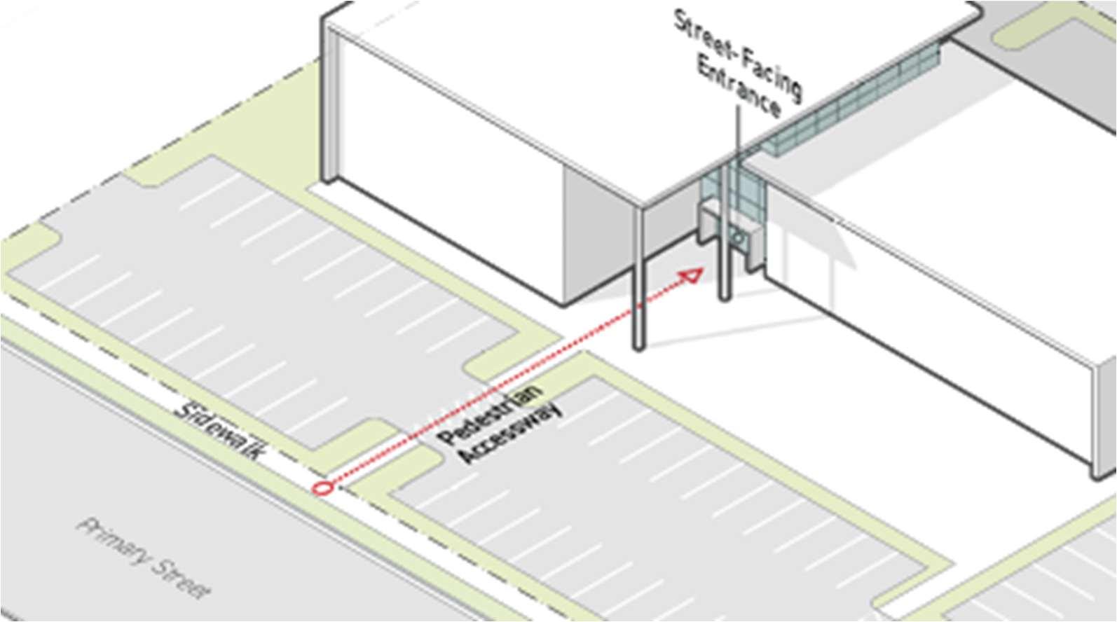
3.G.6. Suggestion: Improve site design and encourage more forms of transportation byproviding pedestrian access requirements.
Front yard parking can provide convenient access to commercial uses for automobile users. However, parking lots can be inhospitable to pedestrian traffic, discouragingwalkers,cyclists,andtransitusersfromaccessingthesespaces.The Zoning Code should promote a more diverse array of transit options by requiring new developments to include some level of adequate pedestrian access through any front yard parking areas. Charlottesville, Virginia offers strong, contextsensitive guidelines for connecting entrances to pedestrian paths. Figure 3-3: Pedestrian Access Development Outcome - University City, MO and Figure 3-4: Pedestrian Access Requirement Example - Charlottesville, VA show a development outcome on Olive Boulevard compared to the access requirements set forth in Charlottesville.
3.G.2. Suggestion: Include use specific standards that encourage amenities for pedestrians.
One way the pedestrian experience can be improved is through use specific standards. Uses that could be frequently visited by pedestrians should contain amenitiesthatpromoteasafeandenjoyableexperiencefornon-automotiveusers. When a use lacks such amenities it can become auto-dependent and nonautomotivemodes of transportation can be discouraged.
3.G.3. Suggestion: Require food services facilities with drive-up windows to includea pedestrian patio at thefront of the building.
When restaurants and food services facilities contain drive-up windows, they can quickly become hostile to pedestrians as the stacking area for vehicles using the drive-up window can often create a barrier between pedestrian paths and entrances. To counteract this effect, food service facilities with drive-up windows could be required to include a pedestrian patio near the front entrance to the building. This patio should include tables, bike parking, and trash receptacles to improve the pedestrian experience without inhibiting the use of drive-up windows.
University City is home to a variety of local and national cultural assets that the City should continuetopreserveandsupport.Furthermore,theCityshouldconsiderprotectingculturalassets in parts of the city other than the southeastern portion. These cultural assets include historic buildings, parks, and community facilities such as schools and libraries. The City’s land use policies should continue to preserve, support, and capitalize on these cultural assets. The Plan recommendsenhancingthevisitorexperienceasawaytopromotetheseculturalassetsinaway that benefits the City.
3.H. Observation:Theprotectionofculturalassetsislargelylimitedtothesoutheastern portion of the City.
The Zoning Code currently protects historic assets through Historic District designations, primarily located in southeastern neighborhoods like the Loop and University Heights. However,theseprotections donotextendtothenorthernandwesternpartsofthecity.Of the22historicdistrictsandlandmarks,justthreearenorthofOliveBoulevard.Thisleaves many historically significant churches, businesses, and other community assets vulnerable to redevelopment without adequate review. The zoning code should be expanded to include new tools like a Cultural Review Overlay District that recognizes social and cultural significance, not just architectural merit. These changes would ensure more equitable preservation and better reflect thefull diversity of the city’shistory.
3.H.1. Suggestion: Create a Cultural Review Overlay District that provides a more flexible structure to protect cultural assets.
While the current Zoning Code’s Historic District designations provide strong protections for nationally and locally recognized sites, this level of formality may notbeappropriateinareasliketheThirdWard,wherearchitecturalpedigreemight be less of afactor in determining cultural significance. To bridge the gap between the Historic District designation and no protections, the City could consider adopting a Cultural Review Overlay District that would allow for the review of culturallysignificantsiteswithoutimposingtherigidconstraintsassociatedwithfull historicdesignation.Thisoverlaycouldfacilitateabalancedapproachbyrequiring proposed developments to undergo a community-centered review process, assessing compatibility with nearby cultural landmarks or traditions. Such a mechanism might empower residents and local leaders to help shape neighborhood change while still encouraging investment and redevelopment. Ultimately, this approach promotes preservation through inclusion, allowing developmenttoproceedinawaythatrespectsandupliftsthecommunity’scultural identity.
3.I. Observation: The development process does little to support the preservation of existing and creation of new cultural assets.
Outside of the historic districts, the current development review process does not adequately provide for development’s impact on cultural resources. Currently, large developments are not required to address how they might affect or enhance nearby cultural assets.
3.I.1. Suggestion: Require a Cultural Impact Study (CIS) as part of the site plan approval process for developments nearidentified cultural assets.
The new Zoning Code should require a CIS as part of the site plan approval process for any development within a designated radius of identified cultural assets, such as historic churches, community centers, or long-standing locally ownedbusinesses.Thisstudycouldevaluatethepotentialeffectsoftheproposed development on the surrounding cultural environment, including risks of displacement, impacts on neighborhood character, and opportunities for communitybenefitagreements.Incorporatingthisrequirementcouldpromotenew developments that respect and enhance the social and historical fabric of University City’s neighborhoods.
3.I.2. Suggestion: Create new design guidelines that address how new developmentsalongkeynodesshouldrespectandenhancecultural assets.
To encourage mixed-use development and enhance walkability, the city should adopt form-based codes along major corridors like Olive Boulevard and Delmar Boulevard. These codes would focus on building form and public realm design ratherthansolelyonlanduse,facilitatingvibrant,pedestrian-friendlyenvironments that align with the comprehensive plan's vision for active, mixed-use nodes.
The City’s neighborhoods are vital to its character. In recent years, new development, housing costs, and stormwater management have threatened University City’s neighborhoods. The ComprehensivePlanrecommendsaddressingtheseissuesbyprotectingthedistinctivecharacter of each neighborhood, providing form-based standards for housing construction, developing a plan for Accessory Dwelling Units, and modernizing the terminology in the zoning ordinance. Furthermore,proactivelyaddressing stormwater management throughflood mitigationplans and improved open space standards could make neighborhoods more resilient to changing environmental conditions.
3.J. Observation: The current housing options restrict housing availability.
OneofthemostvitalsetsoflandusesobjectivessetforthbytheComprehensivePlanare those related to housing. Recently, housing has become increasingly relevant in national planning efforts. If improperly managed, limited housing options can increase home and rental prices, encourage sprawl, and decrease walkability. To ensure that University City continues to be an ideal place to live, providing for in-demanding housing will prove vital.
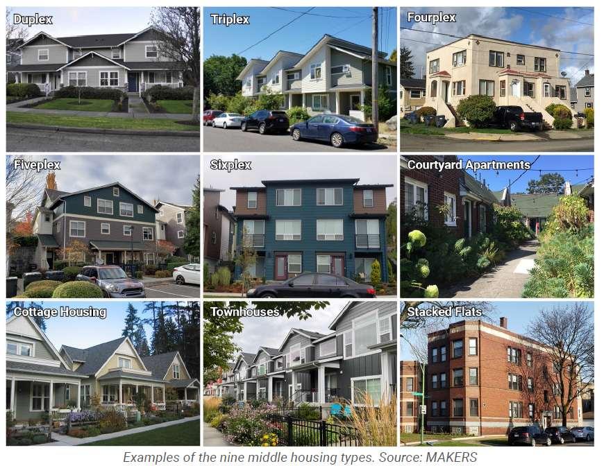
3.J.1. Suggestion: Expand the housing typologies allowed in University City.
ThenewZoningCodeshouldaimtoexpandhousingoptionstoaccommodatethe differentneeds ofresidents.Thecodeshould actonthis approachby establishing arobusthousingtypologyofvarioussizes,styles,anddensitiestoaddressmissing housing gaps. “Missing middle” housing, as displayed by Figure 3-5: Missing Middle Housing Types Examples - Kennewick, WA, like triplexes, multiplexes, cottage courts, courtyard apartments, and build-to-rent communities should be provided throughout the city and allowed in zoning districts where a diverse housing palette is encouraged or preferred.
Figure 3-5: Missing Middle Housing Types Examples - Kennewick, WA
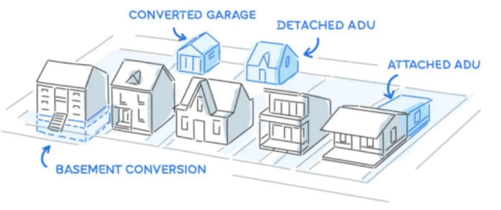
3.J.1. Suggestion: Develop regulationsfor accessory dwelling units.
Accessorydwelling units,or ADUs,for short, aresmaller dwelling units located on the sameproperty as alarger residential use. ADUs can beattachedto, detached from, or inside the principal residential use and can take the form of a garage, basement,orouthouse.Figure3-6:ADULayoutsExample-Cincinnati,OHshows how these different layouts might be developed. Internal, attached, and detached ADUs can enhance housing affordability for both homeowners and tenants, expand the variety of housing options within the community, allow seniors to remain close to family as they age, and optimize the use of existing housing in established neighborhoods. As a result, University City should adopt regulations
for ADUs that encourage the safe and aesthetically pleasing development of accessory dwelling units.
Figure 3-6: ADU Layouts Example - Cincinnati, OH
3.K. Observation: The current landscaping requirements lack context-sensitivity and providefew methods of relief when compliance burdens development. Thecurrentlandscapingarticleisrobust,butitsinflexibilityhindersdevelopmentandlacks context sensitivity. Without context-sensitive regulation, landscaping can become overburdensome for developers, pushing developments towards special approvals and away from the vision set forth in the code. The current code does offer some options for alternative compliance by counting trees with an eight inch or more diameter at breast height as multiple trees. This is a good starting point; however, more alternative complianceoptionscouldbeutilizedtoencouragemorethanjustthepreservationofolder trees.
3.K.1. Suggestion: Create a landscaping and screening matrix to better illustrate which uses require landscaping and how such requirements can bemet.
The current code, through Sections 400.1180 through 400.1230, provides landscaping standards for a variety of different uses. However, their organization makesfindingtheappropriaterequirementdifficult. Consolidatingthesestandards into a landscaping matrix would make navigating the landscaping requirements easier.
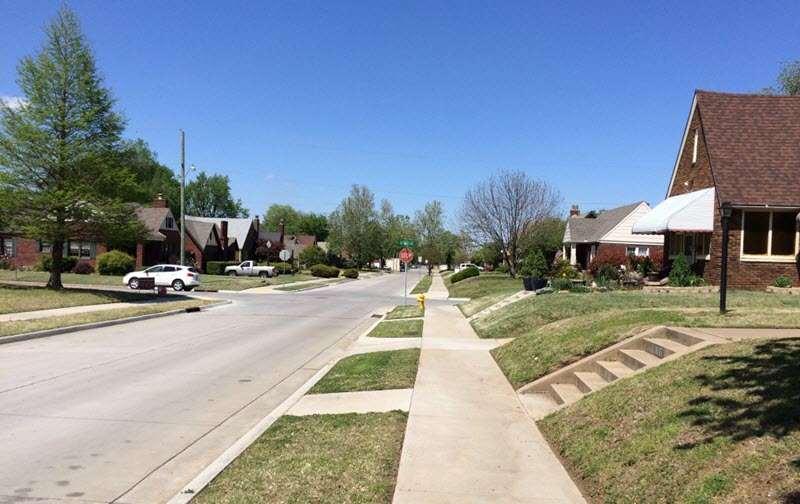
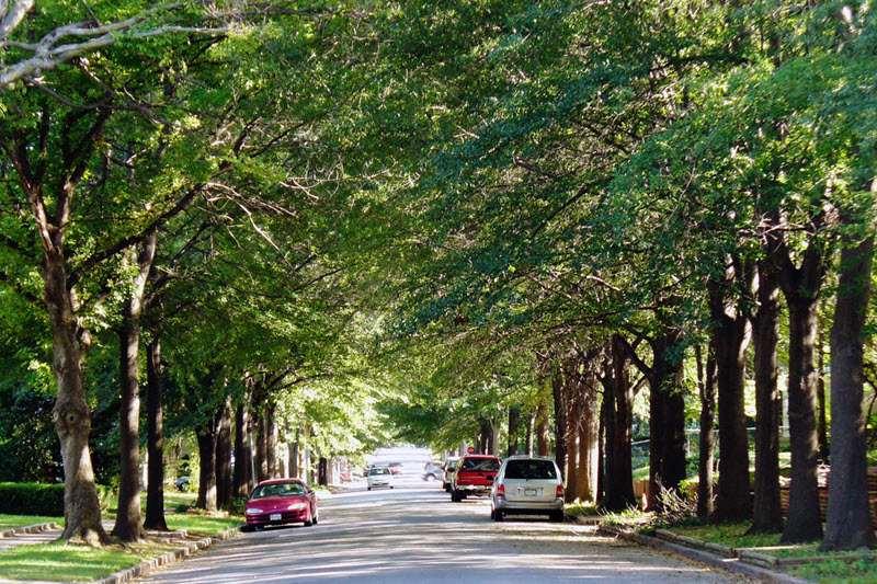
3.K.2. Suggestion: Require trees to be planted within the public right-of-way. Street trees provide important benefits to users of all modes of transportation. Automotive users benefit from increased safety as trees planted within the rightof-way create a visual narrowing effect, slowing traffic and, in turn, improving safety.Pedestriansandcyclistsalsobenefitfromthecoolingprovidedbytreesand aphysicalbarriertofastmovingvehiclesintheright-of-way.Furthermore,property ownersbenefitfromon-sitenoisereduction,energysavingscausedbyshade,and increased privacy benefits. Figure 3-7: Street Without Trees Example and Figure 3-8: Street With Trees Example – Tulsa, OK show the difference between streets with street trees and those without. In short, street trees are a win-win-win for the
community. Residents recognize this. Surveys conducted as part of the 2024 “For the3rd Ward”planshowedthatresidentsbelievethat improvedlandscapingwould contributetothegreatestincreaseintheward’swalkability.ThenewZoningCode should require a certain number of trees to be planted within the right-of-way for both residential and nonresidential uses. This would make University City’s landscaping requirements more robust and improve safety, appearance, and property values throughout the City.
3.K.2. Suggestion:Establishastreet-treefundforthemaintenanceoftreesplanted within the publicright-of-way.
Street trees represent a significant long-term investment that requires ongoing care beyond initial planting. Without dedicated funding, maintenance often becomes neglected when municipal budgets tighten, leading to unhealthy trees, infrastructure damage, and eventual costly removals. Establishing a dedicated street tree fund would ensure that routine maintenance like pruning, disease treatment,andeventuallyreplacementcanoccuronaregularscheduleratherthan reactively. This proactive approach is more cost-effective over time and prevents the public safety hazards that neglected trees can create, such as falling limbs or sidewalk damage. A city-managed fund would allow for professional arborist services and coordinated care across the entire urban forest, treating it as critical public infrastructure rather than placing the burden on individual propertyowners.
3.K.3. Suggestion: Allow for greater flexibility in the design of landscaping areas.
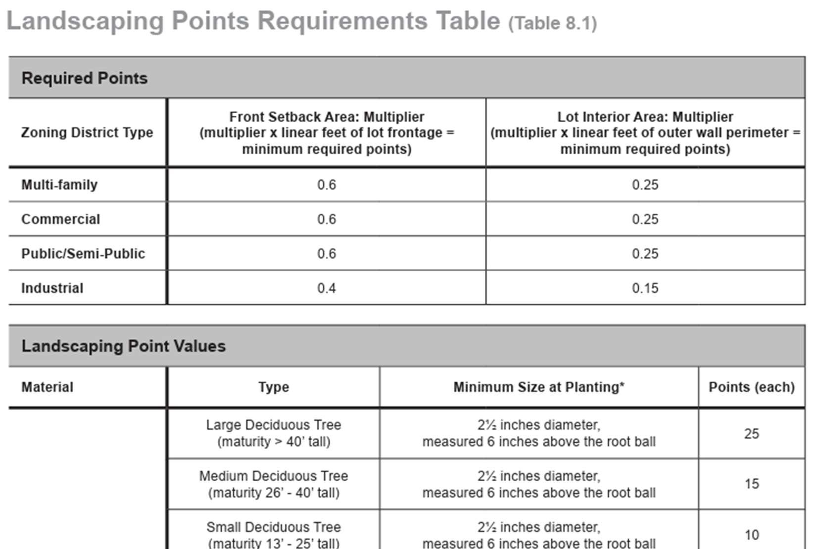
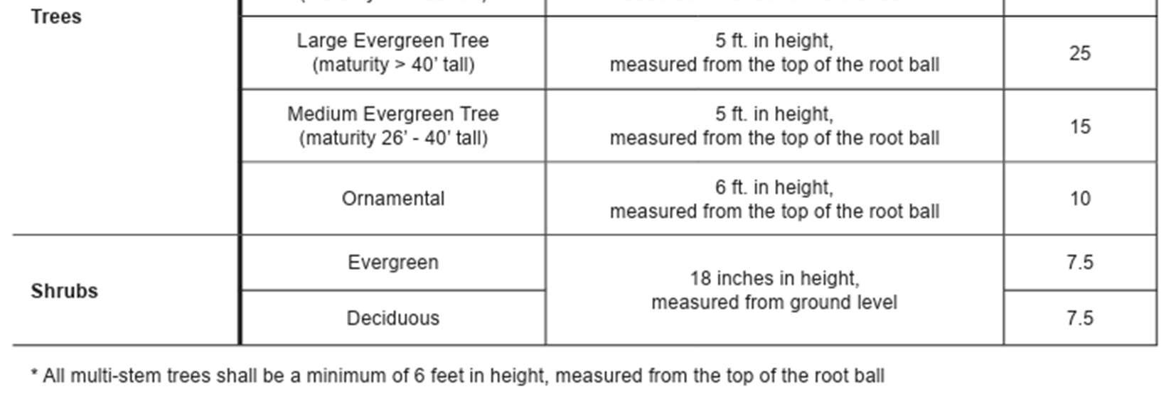
While Sections 400.1180 through 400.1230 provide a variety of standards for the plantingandupkeepof avariety of landscapingmaterials,thecurrentlandscaping requirements are largely confined to minimum tree plantings. Trees are important for creating aesthetically pleasing landscaping areas; however, they are only part oftheequation.Onewaytoallowfor greaterflexibility inlandscapingdesigncould be through a points-based regulatory framework. The new Zoning Code could establish a points-based system where the developer chooses from a menu of landscaping elements to provide sufficient on-site landscaping. For instance, the new code couldrequirevarying landscaping points for different buffer stripwidths, the number of trees on-site, the size and spacing of those trees, use of shrubs, implementationofnativeplantmaterialsandxeriscapingtechniques.Forexample, Columbus,Indianautilizesapoints-basedlandscapingsystemwheretheminimum amountofrequiredpointsissetbyzoningdistrictandlotareaandpointvaluesare calculatedbythematerialandtypeofaplantingasdisplayedinFigure3-9:PointsBased Landscaping Example - Columbus, IN
Figure 3-9: Points-Based Landscaping Example - Columbus, IN
To administer its policies, the City collaborates with citizen entities. However, in recent years, poor communication and lack of involvement have made collaboration more difficult. Developing a better relationship with citizen entities such as The School District of University City and Washington University can allow the City to effectively address areas of concern and implement the goals of the Comprehensive Plan.
3.L. Observation: The current Zoning Code provides little to no opportunities for institutional partners to participate in theplanning process.
WhiletheJointDevelopmentOverlayallowsUniversityCitytocollaboratewithneighboring Olivette, the Zoning Code offers minimal roles for institutional stakeholders like Washington University and the School District of University City to engage in the development review process. As a result, major institutions are treated as standard property owners rather than long-term community partners with significant investments
and impacts. There exists room for proactive coordination to pair institutional planning efforts with the City’s development goals.
3.L.1. Suggestion: Establish a formal consultation procedure with major institutional partners for developments within a specified radius of their properties or that may impact their operations.
To improve coordination on land use decisions, University City should amend its zoning code to establish a permanent advisory committee composed of representatives from Washington University, theSchool District of University City, neighboringmunicipalities,andpublicutilities.Thiscommitteecouldmeetregularly to review proposed zoning changes, long-range plans, and major developments by offering non-binding input to ensure decisions reflect shared priorities. Seattle, Washington employs a similar group to collaborate with its colleges and hospitals through its Major Institution Advisory Committees. Formalizing similar collaboration would promote transparency, align planning efforts across jurisdictions, and help the city proactively address issues like housing, infrastructure, and school capacity ina more integrated and informedmanner.
The structured development and use of land and buildings require comprehensive regulation through the implementation of planning and zoning controls. However, when zoning regulations extend beyond their fundamental purpose of furthering a legitimate state interest such as protecting health, safety, and welfare, they can violate the law, reinforce or create inequalities, andrestrict economicdevelopment. Ifaregulationisnot groundedinalegitimatestateinterest, it risks being overturned in court. For zoning regulations to be effective, they must also be legally defensible and equitable. The best way to ensure their effectiveness is by avoiding unnecessary restrictions and aligning the zoning ordinance withthe Comprehensive Plan’s stated goals.
4.A. Observation: The Zoning Code includes occasional inconsistencies with the Revised Ordinances of Missouri.
When zoning codes have not been updated for an extended period, outdated definitions and provisions can create conflicts with more recent amendments to state law. For example, changes to the Revised Statutes of Missouri (RSMo) may redefine how cities must conduct public hearings, treat nonconforming uses, or enforce zoning decisions through the Board of Adjustment. If the code still references outdated terminology or procedures, it can create legal ambiguity, complicate code enforcement, and expose the city to legal challenges.
4.A.1. Suggestion:Alignalltermswithanyrecent changestotheRevisedStatutes of Missouri.
Since State law is frequently updated, the new Zoning Code should address any inconsistencies between the existing code, the Revised Statutes of Missouri, and other State regulations that address development. This can be best achieved by aligning definitions and terminology with State law.
4.B. Observation: The Zoning Code frequentlyregulates religiousland uses.
The current code differentiates between “churches” and “religious and philanthropic institutions.” As such, some religious uses are permitted in districts where other religious landusesarenot.Additionally,usingtheterm“church”toregulateallreligiousassemblies is an outdated practice. In the spirit of complying with the Religious and Institutionalized Persons Act (RLUIPA), it is best practice to either allow any form ofreligious land uses in a district or not allow them. Including conditional standards for specific types of religious land uses could leavethe City vulnerable to legal challenges in thefuture.
4.B.1. Suggestion: Consolidate religious land uses into oneterm.
Instead of employing the term “church” and “religious or philanthropic institution,” the new Zoning Code should establish a single term such as “religious institution” or “religious land use” to provide religious entities with broad authority touse their land in theirbest interest.
4.B.2. Suggestion: Limit regulations on religious land use to only those standards that are necessary.
The new Zoning Code shouldemploy the simplestpossibleframeworkto regulate religious land useso as to not treat such uses as different from any other use that constitutestheassemblyofsmallorlargegroupsofpeoplewithinaconfinedarea. As such, the new code should only designate where religious land uses are allowed and where they are not allowed. Requirements that treat religious land uses differently from other similar uses should be eliminated.
Zoningregulationsshouldrelatetoacommunity’sexistinganddesireddevelopmentpatternsand shouldfosteraclimatethatfacilitatesinvestmentandredevelopmentwithinthecommunity.When regulations are out of context with existing or desired development patterns, landowners may need to apply for numerous approvals for typical development projects that increase the cost of investment in a community and provide barriers to lower income community members. Further, antiquated or burdensome zoning regulations may disincentivize investment and development, hindering growth.
4.C. Observation: The Zoning Code does not adequately provide for infill development.
Like missing middle housing types, infill development provides attainably-priced housing, reduces urban sprawl, and promotes walkability. Infill development occurs when undeveloped or underdeveloped lots are converted to housing, retail, or other uses that contributeto neighborhood character. The vast majorityof development inUniversity City is infilldevelopment. Assuch, standardsfor infill developmentmust existto allow the City to grow while protecting the surrounding community. The current code includes few standards that are sensitive to this development pattern. An example of these standards is below.
“Prevailing pattern. If a lot is located within a subdivision where the prevailing pattern of development has lot areas greater than six thousand (6,000) square feet or lot widths greater than fifty (50) feet, the minimum lot area or width shall conform to that prevailing pattern in the subdivision. In determining the prevailing pattern of a subdivision, the lot area or lot width of at least ten (10) of the closest lots on the same block frontage in the subdivision shall be considered or, if there are fewer than ten (10) lots, additional lots on the nearest intersecting block frontage, that is "around the corner", may be considered.” (Section 400.160).
4.C.1. Suggestion: Expand flexible infill development standards or create an infill zoning district to allow greater flexibility for infill development.
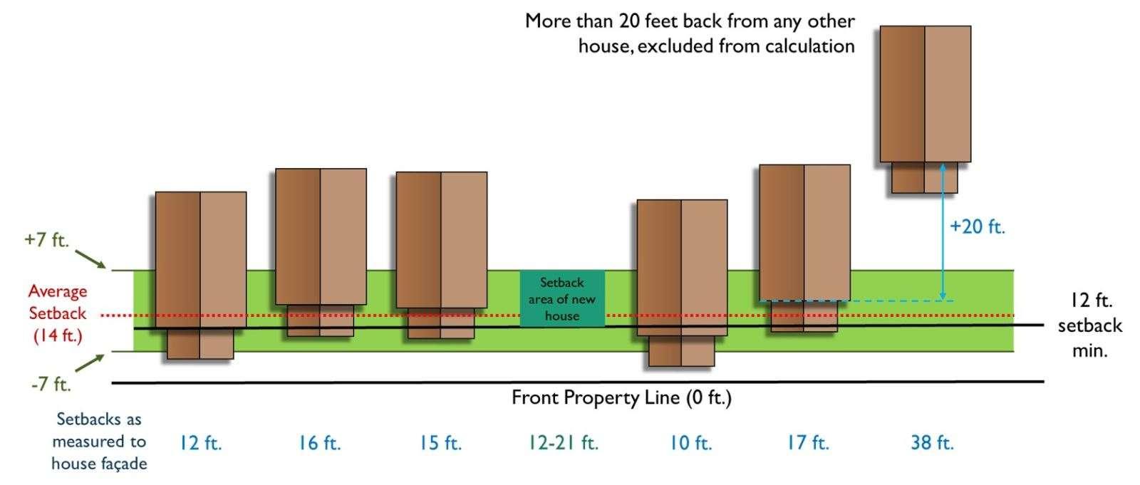
The special standard for lot dimensions in the SR District recognizes that infill development can require relief from the strict requirements of the code. Similar standardsshouldbeextendedtosetbacks,buildingheights,andotherdimensional standards.Figure4-1:SetbackAveragingExample-Manhattan,KSoffersauseful example of how setback averaging can lead to more flexible development standards.AstheThirdWardpreparestocapitalizeonthefundsgeneratedbythe TIF district and Market at Olive development, providing flexible standards to encourage the efficient use of TIF district funds will help improve the ward as a whole.
4-1: Setback Averaging Example - Manhattan, KS
4.D. Observation:ThecurrentZoningCodeprovideslittlerelieffortheadaptivereuseof existing structures.
The zoning code contains rigid use permissions, dimensional standards, and parking requirements can make it difficult to adapt historic structures for new purposes. Furthermore, the code offers too few forms of relief from these provisions. As a result, developersmaychoosenottoredevelopahistoricstructureortoappealforitsdestruction.
4.D.1. Suggestion:Provideflexibilityinuseregulations,parkingrequirements,and dimensional standards for the adaptive reuse of buildings.
Development standards such as parking minimums, landscaping requirements, and dimensional standards should be relaxed or waived where appropriate, recognizing the constraints of retrofitting existing buildings. The newZoning Code could also allow pre-approved adaptive reuse templates or design guidelines to make approvals more efficient while preserving neighborhood character.This tool wouldbeespeciallyeffectiveinpartsofthe3rdWardandalongcorridorslikeOlive Boulevard, where vacant or underutilized buildings could be transformed into affordable housing, community-serving businesses, or nonprofit spaces. By codifying adaptive reuse exceptions, University City can reduce demolitionwaste, preserve architectural character, and catalyze reinvestment in historically underserved areas.
Zoning should be a tool to implement a community’s vision as expressed through planning, development, and Comprehensive Plans. In many instances, a community invests time, funds, andenergyintothedevelopment of aplan, butzoningregulationsareoverlookedor revisedover time in a disjointed manner. This scenario leads to outdated, inconsistent, and disorganized zoning regulations that are cumbersome, intimidating, and costly for property owners and administrators alike, impeding planning goals and economic development. On the other hand, a comprehensive update to the zoning ordinance within the long-term planning process allows for clear, usable, defensible, and consistent regulations that operate efficiently to protect the public interests and encouragedesired outcomes.
4.E. Observation: Too many uses require lengthy conditional use permitapproval. Whileitistypicaltoallowusesby-rightandbyconditionalusepermit,itisgenerallyabest practice to reduce the need for conditional use permit approval asmuch as possible. The currentcoderequiresconditionaluseapprovalfortoomanyuses.Thishindersprocedural efficiency and impedes desired development outcomes. Furthermore, conditional use permit processes causegreater uncertaintysince the City Council usestheir discretionto decide whether the use should be allowed in a district.
4.E.1. Suggestion:Reducethenumberofusesthatrequireconditionalusepermits and provide alternatives.
Asanalternativetotheoveruseofconditionalusepermits,theZoningCodeshould find ways to reduce administrative hearings by implementing the aforementioned use-specific standards and staff-level approvals where necessary. As previously mentioned, these standards are helpful for regulating development scale and use compatibility without a full City Council hearing.
4.F. Observation: Site Plan Review is required for too many uses, including many housing types.
Site Plans can be useful tools to ensure that developments meet the City’s land use standards before construction begins. However, they can also pose barriers to development by introducing detailed approvals for issues like zoning, environmental impact, and infrastructure that can be time-consuming and costly to navigate. These barriers can discourage investment and hinder timely project completion, especially for smaller developers. Evaluatingwhetherthecurrent SitePlanReviewprocessfurthersthe goals of the Comprehensive Plan is important to assessing the tool’s success.
4.F.1. Suggestion: Exclude triplexes and quadplexes from Site Plan Review Requirements.
The current code requires Site Plan Review Requirements all new construction, reconstruction, and expansions except for single-family detached dwelling units. requirementisgoodbecauseitencouragestheconstructionofhousingbyallowing more one and two unit dwellings to be built without the burden of the Site Plan Review Requirements. However, this exception could be expanded to include triplexes and quadplexes to further promote housing creation in University City. Many triplexes and quadplexes can fit the same footprint as a one or two-unit dwelling and contribute to a diversified housing market.
4.F.2. Suggestion: Create aminor site plan review process for development under a certain size.
One way to decrease the number of developments hindered by the Site Plan ReviewprocessistocreateaminorsiteplanreviewprocessthatenablesCitystaff to review and approve development under a certain size. By shifting the decisionmakingauthoritytoCitystaff,theMinorSitePlanReviewProcessismoreefficient and poses less of a barrier to development. The new Zoning Code should allow this expedited approval process for developments under a given gross floor area.
Zoningcodesarecomplexandmulti-disciplinarydocuments,andgiventheubiquity andpowerof zoning, thereisrelativelylittleresearchregardingallthemyriadwaysthatzoninghas contributed to environmental degradation, segregation and differential access to opportunity, and climate change within the United States. At a minimum, zoning has reduced the availability, affordability, and diversity of housing options in communities across the country and impeded investment in older and obsolete properties. Inefficient use of land and excess impervious cover has degraded the built environment and ecosystems. All zoning amendment processes should be developed withconsciousnessandunderstandingofhowzoningpolicycancontributetoinequityandclimate change.
4.G. Observation: The Zoning Code lacks alternative transportation considerations. ThecurrentUniversityCityZoningCodepredominantlyemphasizesvehicularaccessand parking requirements, with minimal attention given to alternative transportation modes such as walking, biking, micromobility (e.g., e-scooters), and public transit. This vehiclecentric framework does not align with contemporary best practices and overlooks opportunities to advance the city’s sustainability, equity, and economic development goals.
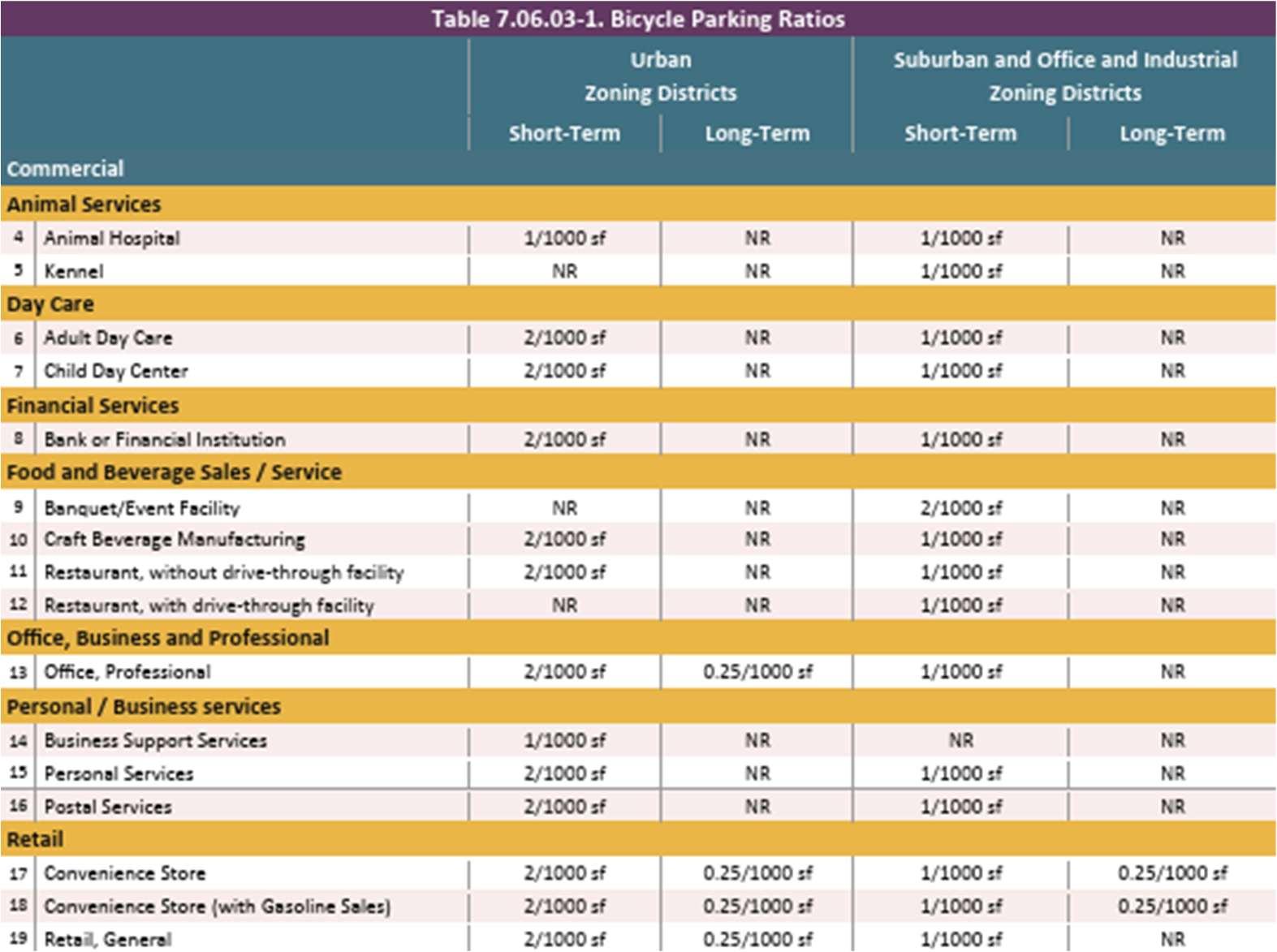
4.G.1. Suggestion: Updatethe bicycle parking requirements.
While the current code contains minimum bicycleparking requirements inSection 400.2145, the new code should emphasize bicycle infrastructure in nodes where pedestrian-oriented and transit-oriented development is desirable. While bicycle parking should be accommodated, it should be done so in practical, contextsensitive manners so that bicycle parking standards are provided and assigned contextually throughout the City. For example, Loudoun County, Virginia employs five development contexts: urban, suburban, transition, rural, and joint land management areas with bicycle parking only required for development in urban and suburban contexts as seen in Figure 4-2: Bicycle Parking Ratios - Loudoun County, VA. University City could follow a similar approach to expanding parking regulationstoincludebicyclefacilitiestoencouragemultimodaltransportationand pedestrian-oriented development in areas near Delmar Boulevard and Olive Boulevard.
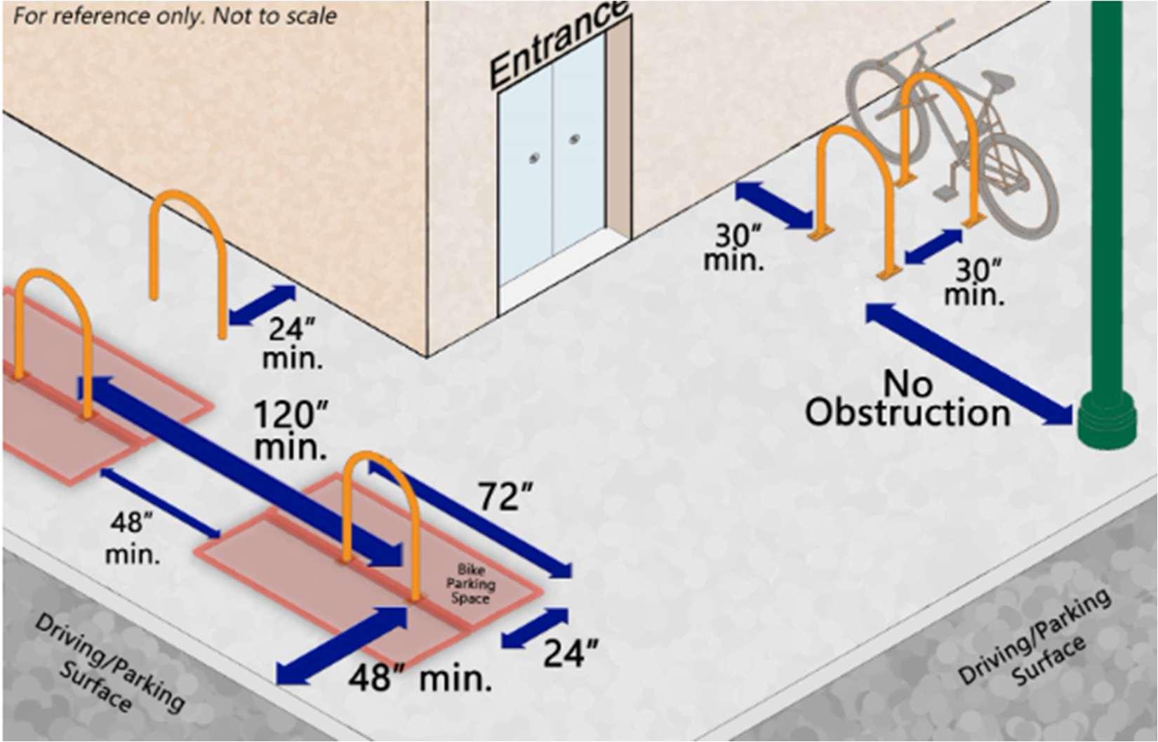
Additionally, while bicycle ratios shouldbe provided, the new Zoning Code should also implement robust standards and specifications to ensure that bicycleparking is not only provided but accommodated in an aesthetically appealing manner through design requirements. Figure 4-3: Bicycle Parking Design Standard Graphic Example - Manhattan, KS offers a variety of structural, locational, and access standards that regulate bicycle parking and its associated facilities in their zoning code. These requirements also encourage amenities such as bike pumps and storage lockers.
4.H. Observation: The code needs electric vehiclecharging stations regulations. In the last decades, electric vehicles (EVs) have gone from a rarity to commonplace. As such, EV charging stations have become crucial for ensuring safe, accessible, and
efficient infrastructure that meets this growing demand. Modern codes can integrate EV charging stations into a community by establishing clear design guidelines, managing congestion, and supporting environmental sustainability.
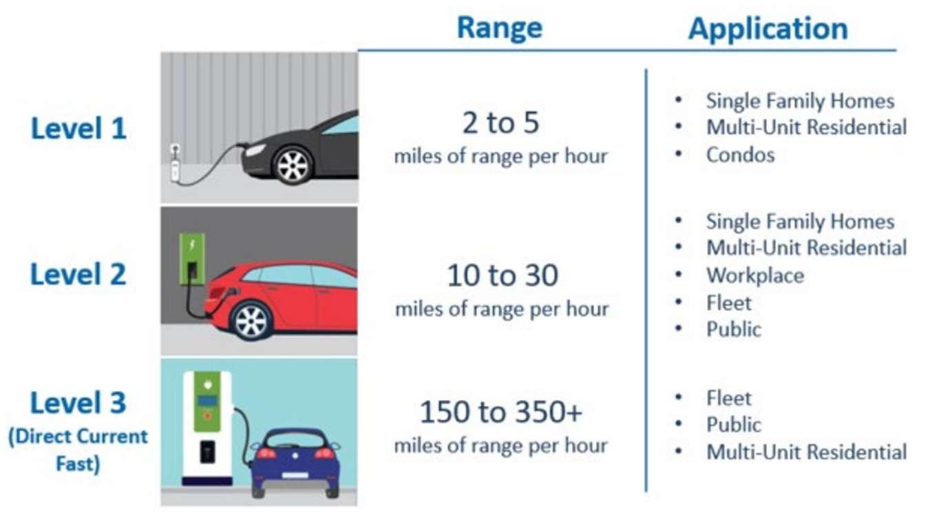
4.H.1. Suggestion: Update the electric vehicle charging station regulations to match thequickly changing popularity of electric vehicles.
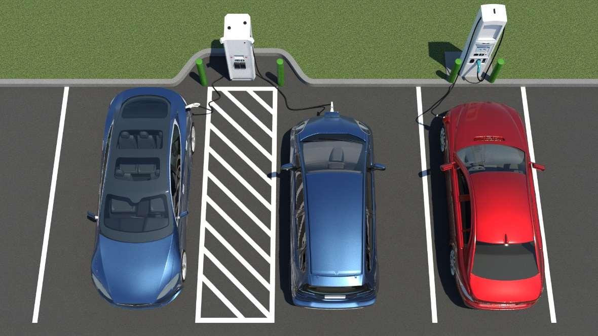
The new Zoning Code should provide guidelines that are consistent with contemporary EV charging station best practices, making sure that the requirements are permissive enough to ensure the construction of the necessary number of EV charging stations. Adequate and context-sensitive screening or buffer requirements canallow for the provision of EV charging stationsthat do not disturbthecharacterofadjacentresidentiallots.Additionally,graphicssuchasthe oneseeninFigure4-4:EVChargingStationGraphicExample-BucksCounty,PA could help illustrate the definition of an EV charging station and explain the requirements of this section. Meanwhile, Figure 4-5: Accessible Electric Vehicle Charging Example - Access-board.gov shows an accessible EV charging station – a development context that should be addressed and encouraged.
4.I. Observation: The lackof renewable energy regulations inhibits thedevelopment of well-designed green energy infrastructure.
The absence of clear renewable energy regulations creates significant uncertainty for developers, investors, and property owners interested in implementing green energy solutions. Without established standards for the placement, size, appearance, and operationofsolararrays,geothermalenergysystems,andotherrenewableinfrastructure, projects face inconsistent approval processes and potentially arbitrary decisions. This regulatoryvoidcouldresultinunnecessarilyprolongedpermittingtimelinesandincreased developmentcosts,especiallyasrenewableenergybecomesmorepopularinthecoming years.Iflackingregulationscreateinefficiencies,UniversityCitycouldloseoutonvaluable investment in sustainable energy systems. Additionally, the lack of thoughtful regulations means that if renewable installations are approved, they may be poorly integrated with surroundingdevelopmentpatternsorfailtoaddresslegitimatecommunityconcernsabout aesthetics, noise, or safety.
4.I.1. Suggestion: Encourage and regulate solar and geothermal energy systems.
The new Zoning Code should create uses and use standards for solar energy systems and geothermal energy systems that regulate the location, size, appearance, screening, and design of such renewable energy systems. Establishing clear regulations can encourage the development of renewable energy systems in residential areas by limiting the costs associated with approval and shortening the development process. Once installed, renewable energy can provide valuable economic relief for households and improve a neighborhood’s stability. For example, rooftop solar panels can decrease a household’s external energy demand, decreasing their utility bill and the burden on utilities. Provided that standards protect the community from the potentially negative side effects of associated equipment, renewable energy systems should be encouraged in University City.
4.J. Observation: The current Zoning Code does not encourage proactive flood mitigation techniques.
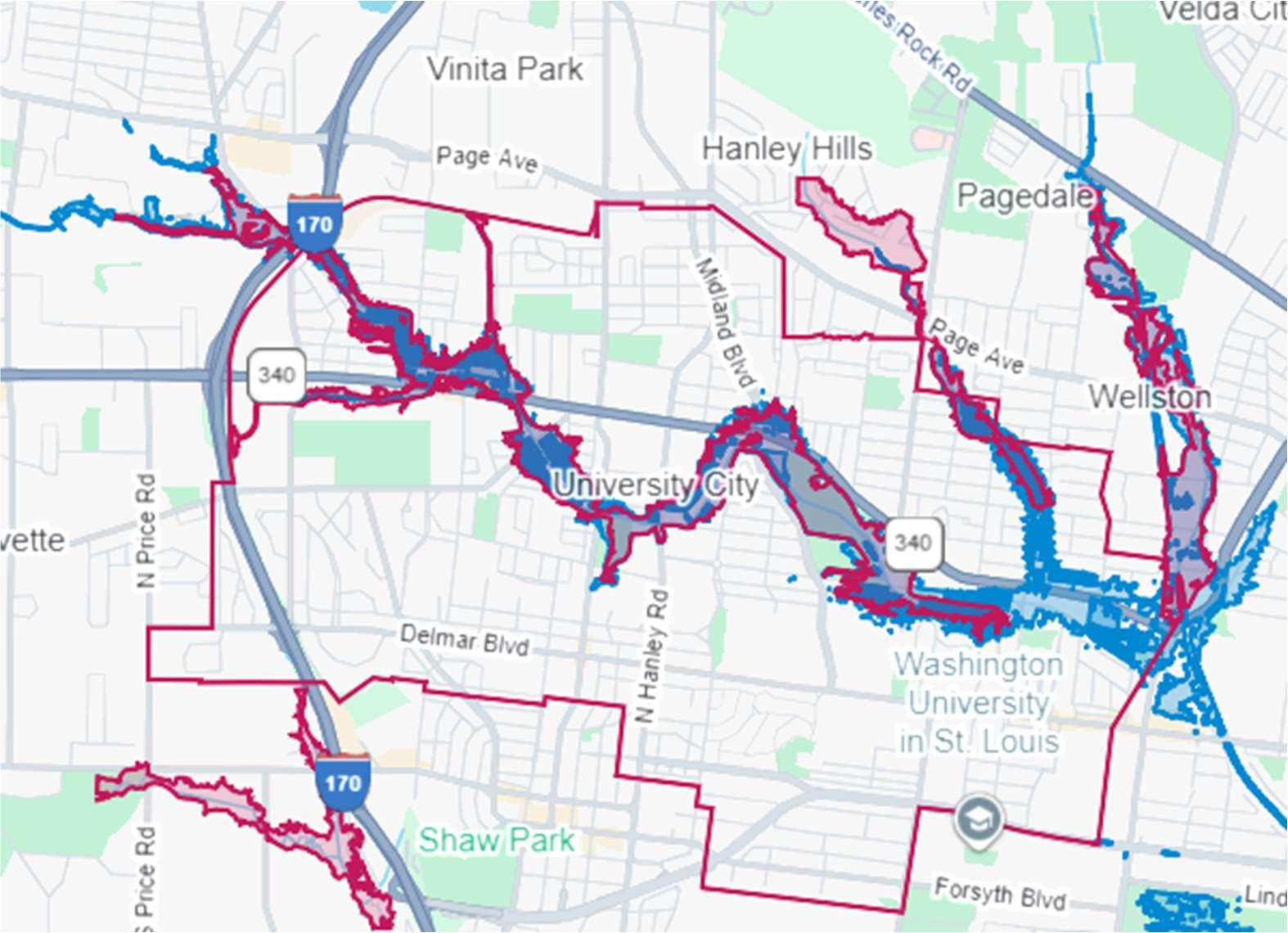
University City includes significant areas within designated floodplains which have experienced considerable infrastructure strain in recent years. Most notably, the River de Peres flooded in 2022, destroying more than 300 homes and causing almost $30 million in damage. The environmental vulnerabilities highlighted by this flood suggest that there are too few proactive flood mitigation strategies in place. This not only threatens property and public safety but also deters long-term investment and development, specifically in theThirdWard.Withoutpropersafeguardsinplace,newconstructionandredevelopment could exacerbate drainage and flooding issues, further burdening an already stressed infrastructure system. Figure 4-6: 2022 River Des Peres Flood Map, published by Holly, Criss, Stein, and Nelson, shows where the 2022 flood impacted University City.
Figure 4-6: 2022 River Des Peres Flood Map
4.J.1. Suggestion: Require site designsto include green infrastructure.
Requiring or incentivizing green infrastructure such as green roofs, bioswales, permeable pavers, and stormwater detention systems for new construction could help address these challenges. One way to implement these standards could be through a floodplain overlay district that reflects FEMA guidance, ensuring all developments within or near flood-prone areas undergo enhanced site design review with a focus on long-term resilience. These changes would help reduce runoff, manage stormwater more sustainably, and protect both residents and property from future flood risks.
Many zoning codes are written by and for city officials, lawyers, and developers, leading to textheavy documents that are difficult to navigate and filled with complicated language. However, all membersofthecommunity,notjustthosewithexpertise,shouldbeabletounderstandthecode. Simple and transparent zoning codes empower people to participate in local planning decisions andadvocatefortheirneeds.Clearregulationsalsoreducecostlymisunderstandingsandensure fair, consistent enforcement for all.
4.K. Observation: The current code in ineffectively organized with information deeply embedded into the document in difficult-to-find locations.
The Zoning Code’s multiple-article structure has significant room for organizational improvement. There are instances where regulations should be in logically connected places but are embedded in seemingly random locations. Furthermore, it takes the code user a long timeto get to the most relevant and important parts of the code.
4.K.1. Suggestion: Modernize the Zoning Code's organizational structure to adhere to contemporary best practices.
The new code needs to place similar and related regulations in nearby locations asopposedtohavingthemsporadicallylocatedacrossmultiplecodes.Thecurrent organizational system should also be rearranged to establish a modern code structure that makes provisions accessible and easy to understand for a wider audience as provided in Chapter 5 Proposed Zoning Code Outline.
4.K.2. Suggestion: Locate high-priority content nearthe beginning of thecode.
The new Zoning Code should emphasize placing the most pertinent information upfront after an introductory title to improve ease and quickness of use. This prevents code users from having to spend considerable time searching for important information.
4.L. Observation: First-timecodeuserscaneasilybedeterredbythecode'scomplexity and arrangement.
Nothing is more important than creating a document that is navigable and easy to understand. Without a strong baseline for how to approach the code, many code users will have to turn to professionals to gather a full understanding of their issue. Failing to provide an adequate explanation of the code discourages or delays small-scale development.
4.L.1. Suggestion: Provideinstructions on how to use the Zoning Code.
Before the code presents the applicable regulations, there should be an instructional guide to educate users on how to navigate the Zoning Code and generally inform the user of the development processes outlined in the code.
4.M. Observation: The Zoning Code contains outdated terms, complex language, vague measurements, and gendered language.
Difficult-to-understand language has its advantages and disadvantages. For instance, vague language can afford more authority for staff and other decision-makers. However,
vaguelanguagecanalsocreateproblemsbymakingregulationsreliantoninterpretations that are both uncertain and inconsistent. Furthermore, complex language can take the form of “legalese” – jargon frequently used in contracts and legislation but are difficult for the average code user to understand. The current Zoning Code contains technical and legal jargon that lengthens the document’s text. There are many sentences containing unnecessary legalese terms such as “thereby, hereto, hereafter, said, hereinafter, etc.” which elongate sentences and make them difficult to understand. An audit found at least 119 vague terms and at least 273 “legalese” terms in the current Zoning Ordinance as seen in Table 4-1: Vague Terms Audit and Table 4-2: Legalese Audit, respectively. Additionally, the code contains numerous instances of explicitly gendered terms such as “his obligation” and “his measurement.” Complex and gendered language hurts a code user’s efforts to understand regulation and the city’s efforts to implement consistent development outcomes.
4.M.1. Suggestion: Clarify all vague language.
While vague language can accomplish policy aims, it should be reevaluated and used sparingly when replacing vague clauses with concrete standards are not applicable.
4.M.2. Suggestion: Reduce legal jargon and use Plain English to improve the code user experience.
These terms should be converted into plain English to improve readability and code comprehension. For example, “hereafter” could be replaced with the phrase “fromthispointforward,”providingaclearerstatementofthelanguage’sintent.By using plain English, the code will be more straightforward, conversational, and easier for the average code user to understand.
4.N. Observation: Graphics are sparinglyused and difficult to understand when used.
The current Zoning Code utilizes only a handful of graphics, making for a text-rich document. This inundation of text makes regulations dense and burdensome for the user by adding to the time needed to understand the Zoning and Subdivision Ordinances’ content. The primarily text-based format of the code does not give readers much of an ideaofwhattheCityrequireswithoutdelvingintothedetailsandcarefullyreadingthetext.
4.N.1. Suggestion: Use reference images, graphics, or diagrams to depict dimensional and design requirements when appropriate.
Graphicsshould illustrate dimensional relationships and development concepts to help explain or amplify content that is sometimes difficult for casual or nontechnical users to understand. Improving the graphics in this code can help address other shortcomings and readability issues mentioned elsewhere in this report.
4.O. Observation: Procedural information is difficult to follow and understand.
Development processes should avoid wasteful and time-consuming processes without preventingopportunitiesformeaningfulpublicinput.Itisessentialtoallowcitizenstovoice input on projects that affect them. As previously discussed in this report, the bestmodern practice is to assign as many processes as possible to staff when a public hearing is not necessary. Usually, public hearings are unnecessary when a use is subject to very clear regulations defined in the code or where the application is the final step in multi-step approval processes where discretionary decisions have already been made. Where development has unique impacts or impacts that are incapable of resolving completely through the standards of the zoning ordinance, public hearings may be needed to give residents an opportunity to weigh in on applications that affect them. Whether or not hearings arerequired,the development process shouldbe as clear and easy-to-follow as possible.
4.O.1. Suggestion: Create a new Chapter for all procedural information.
Procedural information is currently spread across Articles IX through XV causing this information to be spread out and not uniformly formatted. This can make it difficult for code users and administrators to locate the information needed to complete an application or make a decision. Creating a centralized chapter for all procedural information would make the code more user friendly and allow for a more consistent displayof important information.
4.O.2. Suggestion: Map each development process with a newly-established common procedural format.
ThecurrentZoningCodedoesagoodjobat usingarelativelysimilarformat when establishingprocedures.However, byfollowingauniformlayoutfor eachprocess, the development process can become easier to follow all code users. Each development application or process should have subsections that address the questionsfoundinTable4-3:QuestionsToBeAnsweredByCommonProcedural Format below. Answering these questions is a necessary feature that improves code,transparency,readability,andusability.Figure4-7:ApprovalBodySummary Example - Dublin, OH offers a way to display the answers to the the “Action” component in a clear, concise manner.
Component Question to beAddressed
Applicability
Initiation
Completeness
Notice and Hearing
Action
Standards
Subsequent Applications
Appeals
Scope of Approval
Recordation
Who needs to go through this process?
How and to whom is an application submitted?
What is required when an application is ready to process?
What noticing requirements apply toa development application? Are thereany public hearing required? If so, how many?
Who reviews, recommends, and makes decisions? How are decisions made?
What specific standards or criteria apply to the application?
If an applicant withdraws or is denied, can they file a new application? When can a new application be filed?
Who and how can an applicant appeal a decision?
What does this approval allow the applicant to do? What is the next step inthe process?
Who records thefinal document and where can it be found?
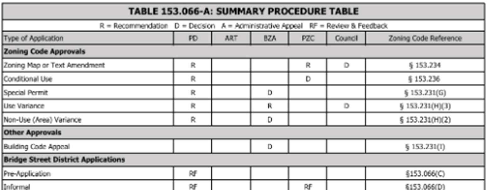
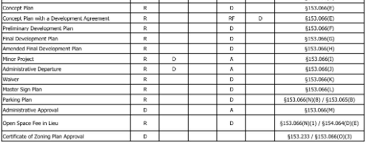
4.O.2. Suggestion: Provide procedural flow charts to better display otherwise complicated procedural information.
The current code does not display important procedural information in a user friendly manner. However, flow charts such as the one seen in Figure 4-8: ProceduralInformationGraphic-CanalWinchester,OH,couldprovideaneffective meansofdisplayingthisinformation.Thenewcodeshouldincludesimilargraphics to display such content-saturated processes in a visually appealing manner and locatesuchgraphicsinanewproceduralinformationchapterasrecommendedby this report.
4-8: Procedural Information Graphic - Canal Winchester, OH
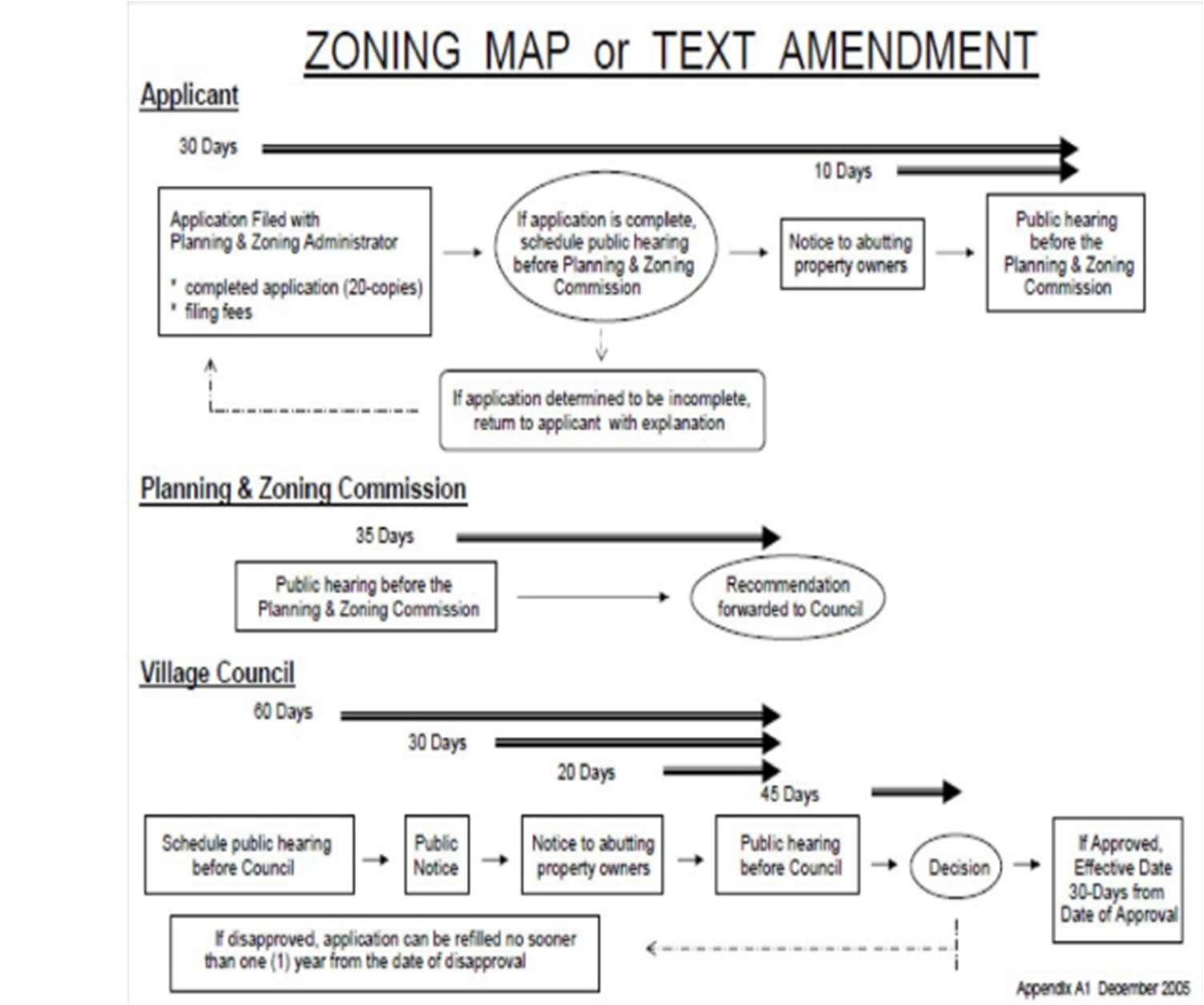
4.P. Observation: Sign standards are difficult for the average code user to understand. Atthestore,ontheirwaytowork,andintheirneighborhoods,peopleseesignseveryday.
However, few people stop to distinctly classify signs. While the practice is necessary for the application of a sign code, sign classifications can confuse code users, especially when those codes heavily rely on text descriptions.
4.P.1. Suggestion: Provide graphics for sign types and measurements.
ThecurrentZoningodereliesentirelyontexttodescribeeachsigntype.Whilethe current language is straightforward, graphics,diagrams, andpictures can improve code users’ abilities to identify which sign types apply. Middleton, WI offers an example of how sign diagrams can provide useful aids to a sign code as seen in Figure 4-9: Sign Graphics Example- Middleton, WI.
4-9: Sign Graphics Example - Middleton, WI
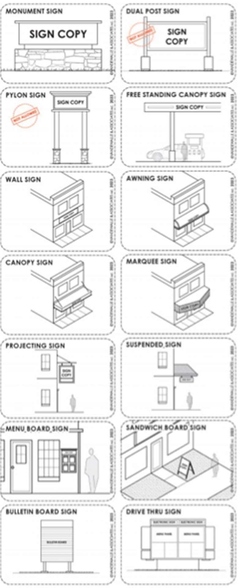
4.P.2. Suggestion:Organizesign standardsintoacomprehensivetabledisplaying sign standards and permissions in each district.
The current ZoningCode includestablesthatsummarizesign allowancesthrough text-heavy regulations located in Article VIII Sign Regulations. This approach complicates finding useful information such as the number of signs allowed per use, the dimensional requirements for said sign, and the illumination standard for signs in the district. These tables can be expanded and improved to show which sign types are allowed by district in amore understandableformat. An exampleof simplifiedsigntablescanbeseeninFigure4-10:SignPermissionMatrixExample - Raleigh, NC where sign allowances by district are summarized at the beginning of the sign regulations.
4-10: Sign Permission Matrix Example - Raleigh, NC
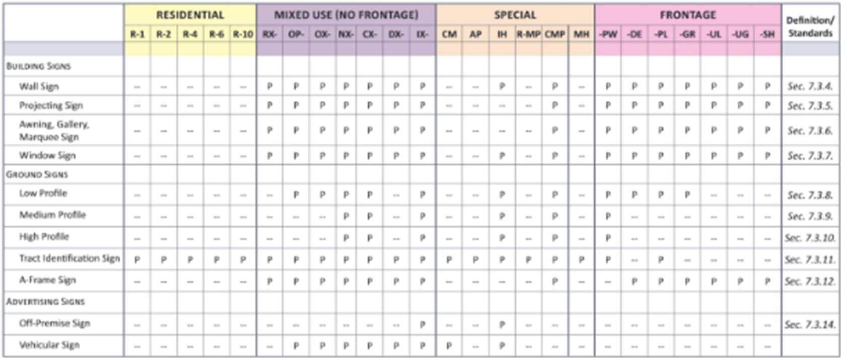
4.Q. Observation: Information about how measurements are calculated is difficult to find.
Nomatterthestructure,allcodesutilizeaseriesofmeasurementtoregulatedevelopment. As such, clearly explaining how to calculate measurements is crucial to ensuring consistency and fairness in a code. Precise measurement guidelines help prevent ambiguity, reduce lengthy appeals, and ensure that all code users follow the same standards. The current Zoning Code lacks a centralized chapter that defines a fair and consistent set of measurements.
4.Q.1. Suggestion: Create a section dedicated to measurements.
Like with definitions, measurements should contain their own section where all measurements are described to prevent ambiguity and confusion. This section should be complete with instructions that explain how to measure various components and graphics that display what certain components look like. Providing this level of clarity will help ensure that all code users understand how to comply with the new Zoning Code’s regulations.
4.Q.2. Suggestion: Remove unnecessary and difficult-to-understand measurements.
Difficult-to-understand measurements can prevent a standard or exception from providing its desired effect. Ensuring that all measurements included in the new Zoning Code are easy to understand will augment the new code’s ability to promote desired development outcomes in University City.
Overview.
The current Zoning Code’s, while containing some valuable provisions, largely fall short of supporting the City's evolving planning goals and objectives, necessitating comprehensive updates across most sections. Significant revisions are needed to align regulations with contemporary urban design principles, sustainability standards, and community development prioritiesthat haveemerged sincetheoriginal code's adoption. Athoughtful reorganization of the codestructurewouldgreatlyimproveusabilityfordevelopers,propertyowners,andcitystaffalike, replacing technical jargon with clear language and incorporating visual aids such as diagrams, charts, and illustrations to clarify complex requirements. By restructuring content logically, rewritingprovisionsinplainlanguage,andaddingvisualguide,thenewZoningCodewillnotonly become more accessible and easier to interpret but will also foster higher quality development outcomes that better reflect the community's vision for growth and preservation.
This report is one of the initial steps in the process as it sets the road map for the new Zoning Code. Therewriteprocesswillbuildontherecommendationswithinthisreportandwillbefurther discussed to determine the best approach to each of the issues presented. Once this report is finalized, the drafting phase of the project will commence.
The following table displays each section of the existing zoning code and analyzes its ability to achieve the goals set forth in the Comprehensive Plan as well as the best zoning practices established in Chapter 1 of this report. Where a section supports a goal or practice, a green box isdisplayed. Where a section prevents the goal or practice from being achieved, ared box is displayed.
Table A-1: Zoning Code Analysis Matrix
ARTICLEI Intent, Purpose and Legal Clauses
Section 400.010 Intent and Purpose.
Section 400.020 Interpretation.
ARTICLEII Definitions
Section 400.030 Definitions.
Section 400.040 Abbreviations.
ARTICLEIII General Provisions
Section
Section 400.050Other Applicable Regulations.
Section 400.060 Establishment of Zoning Districts.
Section 400.070Official Zoning Map.
Section 400.080 Zoningof Streets, Alleys, Public Ways and Railroad Rights-of-Way.
Section 400.090 District Boundaries.
Section 400.100 Rules of Construction.
Section 400.110 Computation of Time.
ARTICLEIV District Regulations
Division 1 "SR" Single-Family Residential District
Section 400.120General.
Section 400.130 Intent and Purpose.
Preserve & Enhance Great Places.AdvanceSharedProsperity.Connect Community. Leverage Assets.Strengthen Livability. Improve Collaboration.
Regulate Only When Necessary.Respect Development Patterns.Zoning Should Not Be a Barrier to the Plan. Promote environmental and social equity. Codes Should Be Accessible to Everyone.
Section
Section 400.140 Permitted Uses.
Preserve & Enhance Great Places.AdvanceSharedProsperity.Connect Community. Leverage Assets.Strengthen Livability. Improve Collaboration.
Regulate Only When Necessary.Respect Development Patterns.Zoning Should Not Be a Barrier to the Plan. Promote environmental and social equity. Codes Should Be Accessible to Everyone.
Section 400.150 Conditional Uses.
Section 400.160 Densityand Dimensional Regulations.
Section 400.170Other Development Standards.
Division 2 "LR" Limited Residential District
Section 400.180General.
Section 400.190 Intent and Purpose.
Section Preserve & Enhance Great Places.AdvanceSharedProsperity.Connect Community. Leverage Assets.Strengthen Livability. Improve Collaboration. Regulate Only When Necessary.Respect Development Patterns.Zoning Should Not Be a Barrier to the Plan. Promote environmental and social equity. Codes Should Be Accessible to Everyone.
Section 400.200 Permitted Uses.
Section 400.210 Conditional Uses.
Section 400.220 Densityand Dimensional Regulations.
Section 400.230Other Development Standards.
Division 3 "MR"Medium Density Residential
Section 400.240General.
Section 400.250 Intent and Purpose.
Section 400.260 Permitted Uses.
Section 400.270 Conditional Uses.
Section 400.280 Densityand Dimensional Regulations.
Section 400.290Other Development Standards.
Section
Division 4 "HR' High Density
Residential District
Section 400.300General.
Section 400.310 Intent and Purpose.
Section 400.320 Permitted Uses.
Section 400.330 Conditional Uses.
Section 400.340 Densityand Dimensional Regulations.
Section 400.350Other Development Standards.
Division 5 "HRO" High Density
Residential/ Office District
Section 400.360General.
Section 400.370 Intent and Purpose.
Section 400.380 Permitted Uses.
Section 400.390 Conditional Uses.
Section 400.400 Densityand Dimensional Regulations.
Section 400.410Other Development Standards.
Division 6 "LC" Limited Commercial District
Section 400.420General.
Preserve & Enhance Great Places.AdvanceSharedProsperity.Connect Community. Leverage Assets.Strengthen Livability. Improve Collaboration. Regulate Only When Necessary.Respect Development Patterns.Zoning Should Not Be a Barrier to the Plan. Promote environmental and social equity. Codes Should Be Accessible to Everyone.
Section
Section 400.430 Intent and Purpose.
Section 400.440 Permitted Uses.
Section 400.450 Conditional Uses.
Section 400.460 Densityand Dimensional Regulations.
Section 400.470Other Development Standards.
Division 7 "GC" General Commercial District
Section 400.480General.
Section 400.490 Intent and Purpose.
Section 400.500 Permitted Uses.
Section 400.510 Conditional Uses.
Section 400.520 Densityand Dimensional Regulations.
Section 400.530Other Development Standards.
Division 8 "CC" CoreCommercial District
Section 400.540General.
Section 400.550 Intent and Purpose.
Section 400.560 Permitted Uses.
Section 400.570 Conditional Uses.
Preserve & Enhance Great Places.AdvanceSharedProsperity.Connect Community. Leverage Assets.Strengthen Livability. Improve Collaboration. Regulate Only When Necessary.Respect Development Patterns.Zoning Should Not Be a Barrier to the Plan. Promote environmental and social equity. Codes Should Be Accessible to Everyone.
Section
Section 400.580 Densityand Dimensional Regulations.
Section 400.590Other Development Standards.
Division 9 "IC" Industrial Commercial District
Section 400.600General.
Section 400.610 Intent and Purpose.
Section 400.620 Permitted Uses.
Section 400.630 Conditional Uses.
Section 400.640 Densityand Dimensional Regulations.
Section 400.650Other Development Standards.
Division 10 "PA" Public Activity District
Section 400.660General.
Section 400.670 Intent and Purpose.
Section 400.680 Permitted Uses.
Section 400.690 Conditional Uses.
Section 400.700 Densityand Dimensional Regulations.
Section 400.710Other Development Standards.
Preserve & Enhance Great Places.AdvanceSharedProsperity.Connect Community. Leverage Assets.Strengthen Livability. Improve Collaboration. Regulate Only When Necessary.Respect Development Patterns.Zoning Should Not Be a Barrier to the Plan. Promote environmental and social equity. Codes Should Be Accessible to Everyone.
Section
Division 11 "PD" Planned Development Districts
Section 400.720 Intent and Purpose.
Section 400.730 Relationship of Planned Development Districts to Zoning Map.
Section 400.740 Coordination With Chapter 405"Subdivision and Land Development Regulations" and Article XIV"Amendments".
Section 400.750 Types of Planned Developments.
Section 400.760 Permitted Uses.
Section 400.770Minimum Planned Development SiteSize.
Section 400.780 Densityand Dimensional Regulations and Performance Standards.
Section 400.790Other Development Regulations For "PD" Districts.
Section 400.800 Dedication and Reservation of Land.
Section 400.810 Sketch Plan Meeting.
Preserve & Enhance Great Places.AdvanceSharedProsperity.Connect Community. Leverage Assets.Strengthen Livability. Improve Collaboration. Regulate Only When Necessary.Respect Development Patterns.Zoning Should Not Be a Barrier to the Plan. Promote environmental and social equity. Codes Should Be Accessible to Everyone.
Section Preserve & Enhance Great Places.AdvanceSharedProsperity.Connect Community. Leverage Assets.Strengthen Livability. Improve Collaboration. Regulate Only When Necessary.Respect Development Patterns.Zoning Should Not Be a Barrier to the Plan. Promote environmental and social equity. Codes Should Be Accessible to Everyone.
Section 400.820 Plan Commission Work Session.
Section 400.830 Preliminary Development Plan Procedure.
Section 400.840 Public Hearing On Preliminary Development Plan and Rezoning Request.
Section 400.850 City CouncilAction On Preliminary Development Plan and Rezoning Request.
Section 400.860 Effect of Approval of Preliminary Development Plan and Period of Validity.
Section 400.870 Final Development Plan Procedure.
Section 400.880 Recording of Final Development Plan.
Section 400.890 Amendments to Final Development Plan.
Section 400.900 FailureTo Initiate Construction After Final Development Plan Approval.
Division 12 "JDO" Joint Development ZoningOverlay
Section 400.910General.
Section
Section 400.920 Intent and Purpose.
Section 400.930 Definitions.
Section 400.940 Boundaries, Applicability and Minimum Developed Area.
Section 400.950 Pre-Application StaffMeeting.
Section 400.960 Conceptual Development Review.
Section 400.970 "JDO" Planned Development District.
Section 400.980 Final Development Review.
ARTICLE V Supplementary Regulations Division 1 Generally
Section 400.990 Intent and Purpose.
Section 400.1000Number of Principal Buildings On A Zoning Lot.
Section 400.1010Conformity With Dimensional and Off-Street Parking Regulations.
Section 400.1020Lot Area and Width Exceptions.
Preserve & Enhance Great Places.AdvanceSharedProsperity.Connect Community. Leverage Assets.Strengthen Livability. Improve Collaboration. Regulate Only When Necessary.Respect Development Patterns.Zoning Should Not Be a Barrier to the Plan. Promote environmental and social equity. Codes Should Be Accessible to Everyone.
Section
Section 400.1030Height Exceptions. Division 2 Setback Exceptions
Section 400.1040General Setback Exceptions.
Section 400.1050Side Yard Setback Exception For Detached SingleFamily Dwellings.
Section 400.1060Setbacks Established By Recorded Subdivision Plat.
Section 400.1070Front Yard Setbacks For Corner Lots of Record.
Division 3 Accessory Uses, Buildings, and Structures
Section 400.1080Permitted Accessory Uses, Buildings and Structures.
Section 400.1090Dimensional Regulations.
Section 400.1100Other Use Limitations.
Division 4 SupplementalResidential Development Standards
Section 400.1110General.
Preserve & Enhance Great Places.AdvanceSharedProsperity.Connect Community. Leverage Assets.Strengthen Livability. Improve Collaboration. Regulate Only When Necessary.Respect Development Patterns.Zoning Should Not Be a Barrier to the Plan. Promote environmental and social equity. Codes Should Be Accessible to Everyone.
Section
Section 400.1120Town-House Dwellings.
Preserve & Enhance Great Places.AdvanceSharedProsperity.Connect Community. Leverage Assets.Strengthen Livability. Improve Collaboration.
Regulate Only When Necessary.Respect Development Patterns.Zoning Should Not Be a Barrier to the Plan. Promote environmental and social equity. Codes Should Be Accessible to Everyone.
Section 400.1125Attached SingleFamily Dwellings.
Section 400.1130Garden Apartment Buildings.
Section 400.1140Elevator Apartment Buildings.
Section
Section 400.1150Common Open Space Requirements For Residential Developments.
Section 400.1160Conversion or Change in Use of Single-Family Dwellings.
Division 5 Multiple-Family Occupancy of A Dwelling Unit Prohibited
Section 400.1165Changing Number of Dwelling Units.
Section 400.1170Occupancy By More Than One Family.
Division 6 Landscaping and Screening Requirements
Section 400.1180Planting Specifications.
Section 400.1190Screening Between Non-Residentialand Residential Zoning Districts.
Section 400.1200Screening of Building Mechanical or Electrical Equipment.
Preserve & Enhance Great Places.AdvanceSharedProsperity.Connect Community. Leverage Assets.Strengthen Livability. Improve Collaboration. Regulate Only When Necessary.Respect Development Patterns.Zoning Should Not Be a Barrier to the Plan. Promote environmental and social equity. Codes Should Be Accessible to Everyone.
Section
Section 400.1210Screening of Rubbish, Garbageand Dumpster Containers.
Section 400.1220Landscaping of Off-Street Parking Areas.
Section 400.1230Installation and Maintenance of Landscaping. Division 7 Fence Regulations
Section 400.1240Height Limitations.
Section 400.1250FenceLocation.
Section 400.1260FenceMaterials.
Section 400.1270Fence Surrounding SwimmingPools.
Section 400.1280Tennis Court Backstop Fences.
Section 400.1290Fences At Street Intersections.
Section 400.1300Permits Required For New and Replacement Fences.
Division 8 HomeOccupations
Section 400.1310Generally. Section 400.1320Restrictions and Limitations.
Preserve & Enhance Great Places.AdvanceSharedProsperity.Connect Community. Leverage Assets.Strengthen Livability. Improve Collaboration. Regulate Only When Necessary.Respect Development Patterns.Zoning Should Not Be a Barrier to the Plan. Promote environmental and social equity. Codes Should Be Accessible to Everyone.
Section Preserve & Enhance Great Places.AdvanceSharedProsperity.Connect Community. Leverage Assets.Strengthen Livability. Improve Collaboration. Regulate Only When Necessary.Respect Development Patterns.Zoning Should Not Be a Barrier to the Plan. Promote environmental and social equity. Codes Should Be Accessible to Everyone.
Section 400.1330Examples of Uses That Frequently QualifyAs Home Occupations.
Section 400.1340Prohibited Home Occupations.
Division 9 Temporary Uses
Section 400.1350Temporary Use Permit Required.
Section 400.1360Temporary Uses Permitted.
Section 400.1370Temporary Commercial Structures Prohibited. Division 10 Wireless Communication Facilities
Section 400.1380Purpose.
Section 400.1382Definitions.
Section 400.1385Application Procedures; Timing.
Section 400.1387General Requirements.
Section 400.1390Permitted Use.
Section 400.1392Administrative Approval.
Section
Section 400.1395Conditional Use Permit Required.
Section 400.1397Commercial Operation Of Unlawful Wireless Communications Facilities.
Section 400.1400Removal of Support Structure.
Section 400.1402Violations And Penalties.
Section 400.1405Appeals.
Division 11 Visibility At Intersections
Section 400.1410Visibility At Intersections Division 12 Performance Standards
Section 400.1420Purpose and Intent.
Section 400.1430Applicability.
Section 400.1440Performance Standards.
Section 400.1450Enforcement of Performance Standards.
Division 13 Adult Business Regulations
Preserve & Enhance Great Places.AdvanceSharedProsperity.Connect Community. Leverage Assets.Strengthen Livability. Improve Collaboration. Regulate Only When Necessary.Respect Development Patterns.Zoning Should Not Be a Barrier to the Plan. Promote environmental and social equity. Codes Should Be Accessible to Everyone.
Section
Section 400.1460Location Restrictions.
Division 14 Utility Facilities Permits and Regulations
Section 400.1470Definitions.
Section 400.1480Facilities Permits.
Section 400.1490Facilities Regulations.
Division 15 Marijuana Regulations
Section 400.1495Standards for Cultivation, Dispensary, Infused Product Manufacturing,Testing And Warehouse Facilities.
ARTICLE VI HistoricLandmarks and Districts
Division 1 Generally
Section 400.1500Intent and Purpose.
Section 400.1510(Reserved).
Division 2 Historic Preservation Commission
Section 400.1520Establishment.
Section 400.1530Membership.
Preserve & Enhance Great Places.AdvanceSharedProsperity.Connect Community. Leverage Assets.Strengthen Livability. Improve Collaboration.
Regulate Only When Necessary.Respect Development Patterns.Zoning Should Not Be a Barrier to the Plan. Promote environmental and social equity. Codes Should Be Accessible to Everyone.
Section Preserve & Enhance Great Places.AdvanceSharedProsperity.Connect Community. Leverage Assets.Strengthen Livability. Improve Collaboration. Regulate Only When Necessary.Respect Development Patterns.Zoning Should Not Be a Barrier to the Plan. Promote environmental and social equity. Codes Should Be Accessible to Everyone.
Section 400.1540Chairperson and Staff.
Section 400.1550Powers and Duties.
Division 3 Designation of Historic Landmarks and Districts
Section 400.1560Application.
Section 400.1570Application Review Procedures.
Section 400.1580Permitted Uses, Use Regulations and Use Limitations
For A Historic Landmark or Within A Historic District.
Section 400.1590Conditional Uses For A Historic Landmark or Within A Historic District.
Section 400.1600Variance To A Historic Landmark or Within A Historic District.
Division 4 Building Permits For A Historic Landmark or Within A Historic District or Within300 Feet of A Historic District or Properties On the National Historic Register
Section
Section 400.1610Building Permit Required.
Section 400.1620Referral to Historic Preservation Commission.
Section 400.1630Review of Building Permit Application.
Section 400.1640Decision and Issuance.
Section 400.1645Appeals.
Division 5 Demolition Permits Reviewed By Commission
Section 400.1650Permit Review.
Section 400.1660Review Procedures.
Section 400.1670Standards of Review For A Permit ToDemolish. Section 400.1680Decision and Issuance.
Section 400.1690Appeals.
Section 400.1700Amendments to Zoning Code.
Division 6 Deterioration
Section 400.1710Abandoned Buildings or Structures.
Preserve & Enhance Great Places.AdvanceSharedProsperity.Connect Community. Leverage Assets.Strengthen Livability. Improve Collaboration. Regulate Only When Necessary.Respect Development Patterns.Zoning Should Not Be a Barrier to the Plan. Promote environmental and social equity. Codes Should Be Accessible to Everyone.
Section
Section 400.1720Unfit Structures.
Section 400.1730City Records.
Division 7 University City Civic Complex Historic District
Section 400.1740Historic District Established.
Section 400.1750District Regulations.
Section 400.1760District Standards.
Division 8 Sutter-Meyer House
Section 400.1770Historic Landmark Established.
Section 400.1780Landmark Regulations.
Section 400.1790Landmark Standards.
Division 9 University City Education Complex Historic District
Section 400.1800Historic District Established.
Section 400.1810District Regulations.
Section 400.1820District Standards.
Preserve & Enhance Great Places.AdvanceSharedProsperity.Connect Community. Leverage Assets.Strengthen Livability. Improve Collaboration.
Regulate Only When Necessary.Respect Development Patterns.Zoning Should Not Be a Barrier to the Plan. Promote environmental and social equity. Codes Should Be Accessible to Everyone.
Section
Division 10 Linden-Kingsbury Historic District
Section 400.1830Historic District Established.
Section 400.1840District Regulations.
Section 400.1850District Standards.
Division 11 Parkview Historic District
Section 400.1860Historic District Established.
Section 400.1870District Regulations.
Section 400.1880District Standards.
Division 12 Theodore Salorgne House
Section 400.1890Historic Landmark Established.
Section 400.1900Landmark Regulations.
Section 400.1910Landmark Standards.
Division 13 Olive Boulevard Historic District
Preserve & Enhance Great Places.AdvanceSharedProsperity.Connect Community. Leverage Assets.Strengthen Livability. Improve Collaboration. Regulate Only When Necessary.Respect Development Patterns.Zoning Should Not Be a Barrier to the Plan. Promote environmental and social equity. Codes Should Be Accessible to Everyone.
Section
Section 400.1915Historic District Established.
Section 400.1920District Regulations.
Section 400.1930District Standards. Division 14 Clifford Row Historic District
Section 400.1940Historic District Established.
Section 400.1950District Regulations.
Section 400.1960District Standards.
ARTICLE VII Off-StreetParking and Loading Requirements
Division 1 Generally
Section 400.1970Intent and Purpose.
Section 400.1980Applicability. Division 2 Design and Location Requirements
Section 400.1990Construction Requirements.
Section 400.2000Vehicular Access and Circulation.
Preserve & Enhance Great Places.AdvanceSharedProsperity.Connect Community. Leverage Assets.Strengthen Livability. Improve Collaboration. Regulate Only When Necessary.Respect Development Patterns.Zoning Should Not Be a Barrier to the Plan. Promote environmental and social equity. Codes Should Be Accessible to Everyone.
Section
Section 400.2010Location of Parking Areas.
Section 400.2020Parking and Loading Area Setback Requirements.
Section 400.2030Dimensional Standards.
Section 400.2040Landscaping Requirements.
Division 3 Supplementary Off-Street Parking and Loading Regulations
Section 400.2050Determination of Required Number of Spaces.
Section 400.2060Disabled Accessible Parking.
Section 400.2070Parking For Multiple Use Buildings.
Section 400.2080Prohibited OffStreet ParkingActivities and Uses.
Section 400.2090Use of Parking Spaces.
Section 400.2100Use of Loading Spaces.
Section 400.2110Lighting.
Preserve & Enhance Great Places.AdvanceSharedProsperity.Connect Community. Leverage Assets.Strengthen Livability. Improve Collaboration. Regulate Only When Necessary.Respect Development Patterns.Zoning Should Not Be a Barrier to the Plan. Promote environmental and social equity. Codes Should Be Accessible to Everyone.
Section
Division 4 Minimum Required OffStreet Parkingand Loading Spaces
Section 400.2120General.
Section 400.2130Exceptions To The Minimum Off-Street Parking and Loading Space Requirements.
Section 400.2140Schedule of OffStreet ParkingSpace Requirements.
Section 400.2145Off-Street Bicycle Parking Requirements.
Section 400.2150Schedule of OffStreet Loading SpaceRequirements.
ARTICLE VIII Sign Regulations
Division 1 Generally
Section 400.2160Intent and Purpose.
Section 400.2170Applicability.
Section 400.2180(Reserved).
Division 2 Sign RegulationsGeneral
Section 400.2190Sign Permit Required.
Preserve & Enhance Great Places.AdvanceSharedProsperity.Connect Community. Leverage Assets.Strengthen Livability. Improve Collaboration. Regulate Only When Necessary.Respect Development Patterns.Zoning Should Not Be a Barrier to the Plan. Promote environmental and social equity. Codes Should Be Accessible to Everyone.
Section
Section 400.2200Determination of Sign Area.
Section 400.2210Maintenance.
Section 400.2220Miscellaneous Regulations.
Section 400.2225Banners, Etc.Permit.
Division 3 Sign Regulations - All Zoning Districts
Section 400.2230Prohibited Signs.
Section 400.2240Permitted Signs.
Section 400.2250Subdivision or Development Identification Signs.
Section 400.2260Sign Placement.
Division 4 Sign RegulationsResidential Uses
Section 400.2270General.
Section 400.2280Single-Family and Two-Family Residential Uses.
Section 400.2290Multi-Family Residential Uses.
Division 5 Sign Regulations - NonResidential Uses
Section 400.2300General
Preserve & Enhance Great Places.AdvanceSharedProsperity.Connect Community. Leverage Assets.Strengthen Livability. Improve Collaboration. Regulate Only When Necessary.Respect Development Patterns.Zoning Should Not Be a Barrier to the Plan. Promote environmental and social equity. Codes Should Be Accessible to Everyone.
Section
Section 400.2310Classification of Signs.
Section 400.2320Primary Signs.
Section 400.2330Secondary Signs.
Section 400.2340Special Purpose Signs.
Division 6 Off-PremisesAdvertising.
Section 400.2350Generally.
Section 400.2360Location of Signs.
Section 400.2370Size of Signs.
Section 400.2380Height of Signs.
Section 400.2390Spacing of Signs.
Section 400.2400Lighting of Signs.
Section 400.2410Permits.
Section 400.2420Miscellaneous.
Division 7 Non-Conforming Signs
Section 400.2425Definition.
Section 400.2430Continuance of Non-Conforming Status.
Section 400.2440Replacement of Components and Repairs.
Section 400.2450Discontinuance.
Preserve & Enhance Great Places.AdvanceSharedProsperity.Connect Community. Leverage Assets.Strengthen Livability. Improve Collaboration. Regulate Only When Necessary.Respect Development Patterns.Zoning Should Not Be a Barrier to the Plan. Promote environmental and social equity. Codes Should Be Accessible to Everyone.
Section
ARTICLEIX Administration and Enforcement
Division 1 Zoning Administrator
Section 400.2460Appointment.
Section 400.2470Duties.
Division 2 Plan Commission
Section 400.2480Plan Commission.
Section 400.2490Responsibilities.
Division 3 Permits
Section 400.2500Building Permit.
Section 400.2510Commercial or Institutional OccupancyPermit.
Section 400.2520Sign Permit.
Section 400.2530Schedule of Fees.
Division 4 Enforcement
Section 400.2540Construction and Use Must Comply With Applications, Plans and Permits.
Section 400.2550Entry and Inspection of Land and Buildings.
Division 5 Violation of This Chapter
Section 400.2560Unlawful Acts.
Preserve & Enhance Great Places.AdvanceSharedProsperity.Connect Community. Leverage Assets.Strengthen Livability. Improve Collaboration. Regulate Only When Necessary.Respect Development Patterns.Zoning Should Not Be a Barrier to the Plan. Promote environmental and social equity. Codes Should Be Accessible to Everyone.
Section Preserve & Enhance Great Places.AdvanceSharedProsperity.Connect Community. Leverage Assets.Strengthen Livability. Improve Collaboration. Regulate Only When Necessary.Respect Development Patterns.Zoning Should Not Be a Barrier to the Plan. Promote environmental and social equity. Codes Should Be Accessible to Everyone.
Section 400.2570ViolationsPenalties.
Section 400.2580Other Remedies.
ARTICLE X Site Plan Review Requirements
Division 1 Generally
Section 400.2590Developments Subject To SitePlan Review.
Section 400.2595Site Plan Approval Required For CertainExempt Institutions.
Section 400.2600Site Plan Submittal Requirements. Division 2 Site Plan Review Procedures
Section 400.2610Site Plan Submission and Distribution.
Section 400.2620Staff Review.
Division 3 City Council Review and Action.
Section 400.2630City Council Review.
Section 400.2640City Council Action.
Section Preserve & Enhance Great Places.AdvanceSharedProsperity.Connect Community. Leverage Assets.Strengthen Livability. Improve Collaboration. Regulate Only When Necessary.Respect Development Patterns.Zoning Should Not Be a Barrier to the Plan. Promote environmental and social equity. Codes Should Be Accessible to Everyone.
Division 4 Site Plan Changes and Amendments.
Section 400.2650Minor Changes.
Section 400.2660Site Plan Amendments.
ARTICLE XI Conditional Uses
Division 1 Generally
Section 400.2670Intent and Purpose.
Division 2 Procedures
Section 400.2680Initiation of The Conditional Use PermitProcess.
Section 400.2690Application and Plan Requirements.
Section 400.2700Review Procedure.
Division 3 Standards For Conditional Use Permit Approval
Section 400.2710Review Criteria.
Section 400.2720Findings of Fact.
Section 400.2730Standards For Motor Vehicle OrientedBusinesses.
Division 4 Terms and Limitations
Section Preserve & Enhance Great Places.AdvanceSharedProsperity.Connect Community. Leverage Assets.Strengthen Livability. Improve Collaboration. Regulate Only When Necessary.Respect Development Patterns.Zoning Should Not Be a Barrier to the Plan. Promote environmental and social equity. Codes Should Be Accessible to Everyone.
Section 400.2740Permit Effective Date.
Section 400.2750Site Plan Approval and Issuance of Permit.
Section 400.2760Failure To Commence Construction or Operation.
Section 400.2770Revocation of Conditional Use Permit.
Section 400.2780Transferability.
Section 400.2790Procedure To Amend A Conditional Use Permit.
Section 400.2800Resubmittalof Conditional Use Request. ARTICLE XIIAppeals and Variances Division 1 Board of Adjustments
Section 400.2810Establishment.
Section 400.2820Membership.
Section 400.2830Powers and Duties.
Section 400.2840Procedures.
Section 400.2850Required Vote.
Section
Section 400.2860Judicial Review of Decision of Boardof Adjustment.
Division 2 Appeals
Section 400.2870Authorization.
Section 400.2880TimeFor Appeals.
Section 400.2890Filing.
Section 400.2900Stay of Proceedings.
Section 400.2910Decision on Appeals.
Division 3 Variances
Section 400.2920Authorization.
Section 400.2930Filing and Submission Requirements.
Section 400.2940Review Considerations.
Section 400.2950Standards For Granting Variances.
Section 400.2960Non-Conforming Situation As A Basis For Variance.
Section 400.2970Conditions and Restrictions.
Preserve & Enhance Great Places.AdvanceSharedProsperity.Connect Community. Leverage Assets.Strengthen Livability. Improve Collaboration. Regulate Only When Necessary.Respect Development Patterns.Zoning Should Not Be a Barrier to the Plan. Promote environmental and social equity. Codes Should Be Accessible to Everyone.
Section Preserve & Enhance Great Places.AdvanceSharedProsperity.Connect Community. Leverage Assets.Strengthen Livability. Improve Collaboration. Regulate Only When Necessary.Respect Development Patterns.Zoning Should Not Be a Barrier to the Plan. Promote environmental and social equity. Codes Should Be Accessible to Everyone.
Section 400.2980Decisions On Variance Application.
ARTICLE XIII Non-Conforming Situations
Division 1 Generally
Section 400.2990Applicability.
Section 400.3000Definitions.
Division 2 Non-Conforming Uses
Section 400.3010Authority To Continue Use.
Section 400.3020Change of Use.
Section 400.3030Discontinuance of Use.
Section 400.3040Non-Conforming Accessory Uses.
Section 400.3050Status of Conditional Uses or Uses Approved Under Site Plan Review.
Section 400.3060Exceptions.
Division 3 Dimensional NonConformities
Section 400.3070Generally.
Section 400.3080Non-Conforming Lots of Record.
Section Preserve & Enhance Great Places.AdvanceSharedProsperity.Connect Community. Leverage Assets.Strengthen Livability. Improve Collaboration. Regulate Only When Necessary.Respect Development Patterns.Zoning Should Not Be a Barrier to the Plan. Promote environmental and social equity. Codes Should Be Accessible to Everyone.
Section 400.3090Non-Conforming Structures.
Section 400.3100Exceptions To Non-Conforming Residential Structures.
Section 400.3110Other Dimensional Non-Conformities.
Section 400.3120Damage or SubstandardConditions.
ARTICLE XIVAmendments
Division 1 Generally
Section 400.3130Typesof Amendments.
Division 2 Application and Submission Requirements
Section 400.3140Application.
Section 400.3150Limitations On Filing An Application.
Section 400.3160Submission Requirements.
Division 3 Application Review Procedure
Section 400.3170Staff Review.
Section Preserve & Enhance Great Places.AdvanceSharedProsperity.Connect Community. Leverage Assets.Strengthen Livability. Improve Collaboration. Regulate Only When Necessary.Respect Development Patterns.Zoning Should Not Be a Barrier to the Plan. Promote environmental and social equity. Codes Should Be Accessible to Everyone.
Section 400.3180Plan Commission Review.
Section 400.3190Public Hearing.
Section 400.3200City Council Action.
Section 400.3210Withdrawal or Application.
ARTICLE XVPublicNotices
Division 1 Generally
Section 400.3220Notice of Public Hearing.
Division 2 Notification of Property Owners
Section 400.3230Regarding Proposed Amendments To The Official Zoning Map.
Section 400.3240Regarding Applications For Conditional Use Permits or Variances.
Section 400.3250Exceptions.