


Canal Winchester, OH
Canal Winchester, OH
This report evaluates the efficiencies and deficiencies of the current Planning and Zoning Code in its ability to achieve the community’s objectives as stated in the 2023 Canal Winchester Community Plan as well as modern planning best practices. This report was produced by a team of planning professionals that relied on the 2023 Community Plan, professional expertise in the planning discipline, familiarity with national best practices, and an in-person visit to CanalWinchester.
This report aims to set a clear vision for the upcoming Planning and Zoning Code rewrite project by highlighting where the current code promotes or prevents desired development outcomes.
Formally known as “Canal Winchester: A Community in Action”, the 2023 Community Plan isthecity’sgeneral comprehensive plan. The document is a long-rangeguide for policy-making in the city and provides a vision for future development in Canal Winchester based on a Statement of Core Values. The plan evaluates topics including land use, community character, housing, neighborhoods, transportation, economic development, natural and cultural resources, and public utilities and services. The following goalsfor land useand zoning were identifiedin theplan:
1. Support land usesthat respect existing neighborhoodsand open spaces.
2. Encourageresidential development that meetsmarket demand.
3. Promote the development of mixed-use, walkable development patterns.
4. Incorporate unique and functional community design components.
5. Identify gateway locationstoannounce arrival into Canal Winchester.
6. Emphasize high quality development and design.
The 2018 Thoroughfare Plan, as amended in 2021, provides a classification of streets in the city by identifying their purpose, function, and importance within the overall roadwaynetwork.Theplanevaluatessevenalternativeroadwaynetworkscenarioswith the goal of addressing the increased traffic demand expected to impact Central Ohio by 2050. Theplan further identified the following land useand zoninggoals:
1. Enhancenorth-south and east-west connectivity.
2. Promote the utilization of Diley Road, BixbyRoad, and US-33.
3. Alleviate congestion on Gender Road.
The 2017 Parks and Recreation Plan establishes a holistic and informed blueprint for the future growth and development of public and open spaces within the city. To capitalize on the city’s economic success in the mid-2010s, the plan aims to improve thequalityoflife forCanalWinchester’sresidents,employees,and visitorsby settinga
vision for the City’s parks. Through quantitative and qualitative analyses alongside public input, the planestablishedthe following goals:
1. Improve parks in hierarchical order.
2. Expand city-wide bikinginfrastructure.
3. Increasethe number of waste disposal receptacles.
4. Improve signage to increase awareness of parks.
5. Strengthen landscaping.
6. Upgrade furnishing.
The Old Town District is a combination of the Historic and Preservation Districts of CanalWinchester.AdoptedinJanuary2017,theOldTownPlanfocusesonpromoting this district by evaluating the wants and needs of residents and stakeholders in the community, identifying focus areas for redevelopment, and developing a vision and strategy for these areas to help the City respond to opportunities in the regional marketplace. Additionally, the Old Town Plan established principles to guide the City inthedevelopmentofpublicprojectsthatenhancethepedestrianrealmandpromote future growth. After receiving public input and analyzing regional market trends, the Old Town Plan set forth the followinggoals
1. Preserve historic architectural styles intheOldTown.
2. Establish a refined vision for theOld Town.
3. Identify the opportunity for new catalyst projects that will generate City revenue whileenhancing the character and brand of the community.
4. Support future development throughcreative redevelopment strategiesand incentives.
5. Create a plan that has broad public and private sector support.
6. Support futurefunding initiatives.
The 2012 Old Town Guidelines provide guidance for preservation, rehabilitation, and development efforts within the oldest portions of the community. The need for guidance was established in the 1999 Community Plan and grew in importance as Canal Winchester continued to thrive. In addition to providing
1. Preserve historic architectural styles intheOldTown.
2. Encouragedesign that complements historic buildings.
Community Plan Objective 1: Support a system of organized and balanced land uses within the community that respects existing neighborhoods and open spaces.
A. Observation: Dimensional and bulk requirements may restrict otherwise permissibleanddesirabledevelopmentoutcomes.
A.1. Recommendation: Remove or consolidate unnecessary or redundant dimensional or bulk requirements.
To increase clarity and reduce the negative effects of overregulation, eliminate unnecessary or redundant dimensional standards and bulk requirements. Unnecessary requirements in the current code include required basements.
A.2. Recommendation: Choose a single dimensional standard for a minimum floorareainsteadofpresentingtwodifferentminimummeasurementsbased on number of stories.
The current dimensional standards provide both a minimum ground floor area and a minimum finished floor area for multiple types of dwellings; the newPlanning andDevelopmentCodeshould provide onlyonestandard for floor area or eliminate suchrequirement altogether.
A.3. Recommendation:Decreasethefrontsetbackrequirementsforlow-intensity commercial uses to promote pedestrian-friendly storefronts.
The Neighborhood Commercial District is currently designed to promote small retail and personal service establishments within a short distance of residentialareas.Toencouragethisdevelopmentpattern,theseusesshould belocatedclosetothestreettoaccommodatepedestriansandcyclistsfrom nearby neighborhoods. However, the minimum front setback in this district is50feet,thesamefrontsetbackthatisrequiredfortheGeneralCommercial District which is designed for more auto-oriented development. Bringing storefrontsintheNeighborhoodCommercialDistrictsclosertothestreetwill encourageneighborhood retail within walking distance of nearby residents.
A.4. Recommendation: Reduce the required setback and increase the maximum height for accessory structuresin theOld Town.
Since 2007, the City of Canal Winchester has provided 10 variances of setback or height requirements for accessory structures. This figure represents over 50% of the variances granted within that same time period, indicating that updating the dimensional standards for accessory structures
in districts where such structures are desirable could contribute to desired development outcomesandreducethenumberofvarianceapplications.To betteralignthedimensionalstandardsforaccessorystructures,therequired setbacks should be reduced and maximum height increased in the Old Town.
A.5. Recommendation: Adjust lot dimensional standards to match desired development outcomes.
Lot dimensional standards serve as a critical tool for cities to regulate development density by establishing minimum requirements for lot area, coverage, and frontage within zoning districts. For Canal Winchester, these parameters directly influence project layouts, density outcomes, and permissiblelanduses.TheupdatedPlanningandZoningCodeshouldrevise thesestandardstoalignwiththecity’svisionforfuturegrowth,ensuringthey reflect community members’preferences.
A.6. Recommendation: Create dimensional standardstablesfor each district. While building floor area standards are currently presented in a table, there is considerable room for improvement. Locating all dimensional standards for each district in a table, as seen in Figure 3-1: Example Dimensional Standards Table - Reynoldsburg, OH, would improve the code user experience by making information easier to find and simpler to understand. Suchtablescanbecombinedwithgraphics,asshowninFigure3-2:Example Dimensional Standards Table - Gaithersburg, MD below.
Figure 3-1: Example Dimensional Standards Table - Reynoldsburg, OH
B. Observation: Information regarding what constitutes specific uses, where thoseusesareallowed,andhowtheyareregulatedisdifficulttofind.
Toestablishabalancedandharmoniousseparationoflanduses,thedifferentuses allowed or restricted by the code must be easily distinguishable, conveniently located, and clearly regulated. The current Planning and Zoning Code falls short of this goal.
To start, the code currently provides use allowances for each zoning district at the beginningofthedistrict’ssection,wheretheyarelistedone-by-one.Thisapproach causes the same use to be listed in multiple ways, complicates the code user experience,and hinders theCity’sability to update the code.
Furthermore,useregulationsarescatteredthroughoutthecode,makingitdifficult for the average code user to identify the standards that apply to their desired use. When code users cannot decipher the code, they are forced to hire experts, disregard the code, or opt not to develop. All three options fail to contribute to a systemof balanced and desirable land use in theCity.
Further complicating these issues is the fact that many land uses are duplicated, undefined, or definedmultiple times. Whenthedistinctionbetweendifferent land uses is not clear, code users can become unnecessarily deterred, discouraging development.
B.1. Recommendation: Eliminate listed use allowances by moving the comprehensive usetable.
Many contemporary zoning codes include a comprehensive use table that consists of a matrix of all uses identified in the code and all zoning districts. The current Planning and Zoning Code hides this table in Appendix C, making it difficult to find. The new Planning and Zoning Code should locate thecomprehensiveusetablewithinachapterwithotherusepermissionsand standards.
B.2. Recommendation: Replace Chapter 1181 Special Provisions with a section called "use specific standards" whereall use regulations arelocated. In its current form, Chapter 1181 Special Provisions mostly consists of additional regulations relating to specific uses. While many of these regulationsprovidevaluablecontrols,theyaredifficulttolocatebecausethe title “Special Provisions” is vague. This chapter should be made a section, renamed to “Use Specific Standards,” and relocated to thechapter covering use permissions and standards as recommended above. Furthermore, any use standards located elsewhere in the code should be relocated to this sectionto centralizeusestandards.
B.3. Recommendation: Definealluses and eliminate duplicated terms.
A code is only as strong as its definitions. Even with perfectly tailored use permissions and use standardsbecomedifficult to enforce if all uses are not adequatelydefined.Strongusedefinitionscreateclearboundariesbetween separate uses without creating arbitrary distinctions between uses with similaroridenticaleffects.Forexample,dentistofficesandbarbershops are certainly different uses; however, when considering their effects on the surroundingcommunity,theirdifferencesarehardertoidentify.Assuch,the new code might opt to include both these uses as “personal services” uses. Once these uses are consolidated, the new Planning and Zoning Code should define every term in a manner that minimizesconfusion and overlap.
B.4. Recommendation: Definea “banquet hall”or “event center” use.
The new Planning and Zoning Code should establish a definition for a "banquet hall" or "event center” to address the unique operational characteristics and impacts of these facilities. Such a definition might look like the following: “a facility or building available for lease by private parties that may include kitchen facilities for the consumption of food or the sale of alcoholic beverages on premises during a scheduled event.” This designationwouldallowforappropriateregulationofparkingrequirements,
hours of operation, noise limitations, and other performance standards specific to venues that host large gatherings. By defining this use, Canal Winchester can better manage the potential neighborhood impacts such as noiseandtrafficwhileprovidingclearguidancetotheownersandoperators of such facilities.
B.5. Recommendation: Provide usespecific standards for mobile vendors. The new Planning and Zoning Code should establish use-specific standards for mobilevendors,such asfood trucks,to addresslocationalrequirements, operating hours, design standards, and permitting processes. These standards could balance the growing popularity of food trucks and other mobile businesses with considerations for public safety, aesthetics, and potential impacts on brick-and-mortar establishments. By incorporating dedicated mobile vendor regulations, the City can support this dynamic sector of the local economy while ensuring appropriate oversight and community integration.
C. Observation: The zoning of newly annexed land limits the City’s ability to implement desired development outcomesoutlined in the 2023 Community Plan.
Canal Winchester currently zones all newly annexed land as “Exceptional Use” by default.Theareaisthenrezonedafteradevelopmentplanissubmitted.Whilethis procedure does not present a significant barrier to development, it does limit the City’sinfluenceonthecharacterofrecentlyannexedland.Throughfocusareasand mapping, respectively, both the 2023 Community Plan and Future Land Use Plan promote greaterinfluencefromtheCityincontrollingthedevelopmentoutcomes of theseareas. Thenew Planningand Zoning Code should reflect thischange and enable the City to better control development outcomes.
C.1. Recommendation: Create a process for zoning newly annexed land that enablesthe City to efficiently implement its visionforfuture land use. Instead of automatically applying a restrictive zone to newly annexed land and allowing developers to apply for rezoning, the City should determine howtozonenewlyannexedland.Thispre-applicationofzoningwouldallow the City to establish its vision for future development in the area. Creating a consistent process that affords the City broad planning power without violating individuals’ property rights is key to accomplishing the objectives set forth through focus areas in the 2023 Community Plan and the Future Land Use Plan.
D. Observation: Restricting lots to one principal use limits opportunities for mixed-usedevelopment.
Currently, all uses in Canal Winchester are divided into principal and accessory uses;onlyoneprincipaluseisallowedperlot,whereaseachlotisaffordedmultiple
9
accessory uses. This system, while similar to peer communities across the country, prevents mixed-usedevelopment and contributesto inefficient land use.
D.1. Recommendation: Allow multiple principal uses per lot in mixed-use and commercialdistricts.
ThenewPlanningandZoningCodeshouldallowmultipleprincipalusesper lot where mixed-use development is deemed desirable. In the Old Town, near Waterloo Road, and in various commercial areas, the Future Land Use Plan encourages development patterns that thrive when multiple uses can coexist on one lot.
E. Observation:Thecurrenthousingoptionsrestricthousingavailability.
Housing, particularly in communities like Canal Winchester, tends to be limited in diversity, offering mostlydetached, single-unit dwellings. Limited housing options increases home and rental prices, encourages sprawl, and decreases walkability. AsCanalWinchesterisset togrowincomingyears,providingforamixof housing typeswillprove vital.
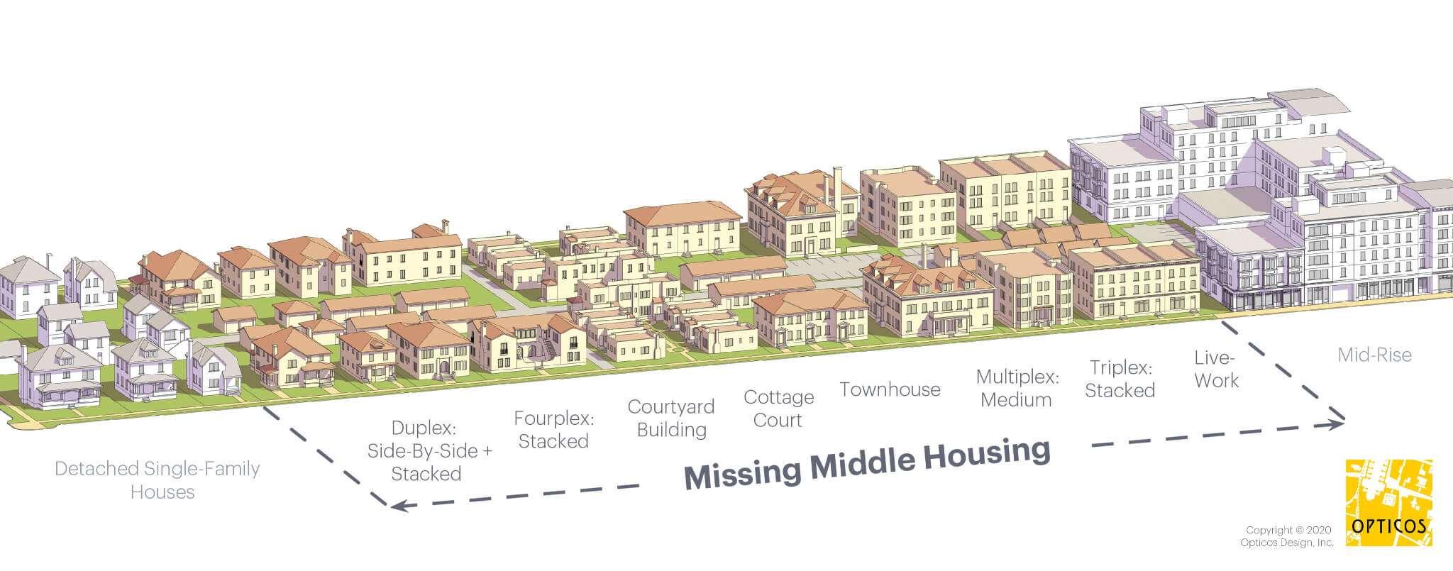
E.1. Recommendation: Expand the housing typologies allowed in Canal Winchester.
“Missing middle” housing, as displayed by Figure 3-3: Missing Middle Housing Types, like triplexes, multiplexes, cottage courts, and courtyard apartments should be allowed in zoning districts where a diverse housing paletteisdesired.Thesehousingtypesshouldeachincludeacleardefinition andarobustsetofstandardscontrollingtheirdevelopment.Thefollowingis a list of housing typologies that could be implemented in Canal Winchester along with a brief definition.
Triplexes aredwellingsdividedintothreeindependentunitscontainingtheir own kitchen, bathroom, and living space. These units can be organized either vertically, horizontally, or in somecombination of both.
Multiplexes aredwellingsdividedinto four ormoreunits.Whilesimilarto an apartment building, multiplexes are typically smaller in scale and provide fewer dwellingunits.
Cottage courts are group of detached dwellings arranged around a shared, central open space or courtyard. These dwellings are typically smaller in scale than the average detached dwelling and are granted a reduced setback from other units within the cottage court development, although their setback fromadjacent propertiesis typically unchanged.
Courtyard apartments are apartment buildings typically containing more thantenunitsorganizedaroundashared,commonopenspaceorcourtyard.
3-3: Missing Middle Housing Types
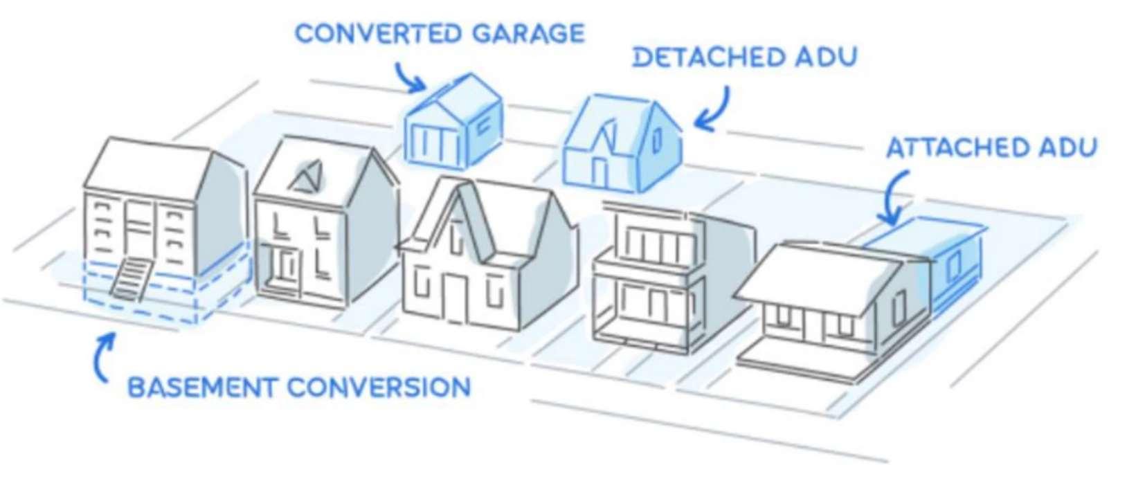
E.2. Recommendation: Develop regulations for detached accessory dwelling units.
Accessory dwelling units (commonly referred to as “ADUs”) are smaller dwellingunitslocatedonthesamepropertyasalargerresidentialuse.ADUs canbeattachedto,detachedfrom,orinsidetheprincipalresidentialuseand can take the form of a garage apartment, carriage house, or basement unit. Figure3-4:ExampleADULayout-Cincinnati,OH,showshowthesedifferent layouts might be developed; however detached ADUs and converted garages are the most appropriate layouts for ADUs in Canal Winchester. Furthermore, enhanced ADU guidelines should ensure that utilities are sharedbytheprimaryresidenceandtheADUto prevent overburdeningthe sanitary and sewer network. However, if implemented properly, ADUs can enhancehousingaffordabilityforbothhomeownersandtenants,expandthe variety of housing options within the community, allow seniors to remain close to family as they age, and optimize the use of existing residential properties in established neighborhoods.
3-4: Example ADU Layout - Cincinnati, OH
E.3. Recommendation: Develop regulationsfor “in-law suite” conversions.
Permitting “in-law suite” conversions would enable homeowners to transform existing basements, garages, and detached structures into secondary dwelling units. To uphold safety standards, neighborhood compatibility, and infrastructure capacity, the new Planning and Zoning Code should also develop standards regulating the design of these conversions. Establishing clear guidelines for parking, utilities, and occupancy would help prevent overcrowding and preserve the character of residential areas. This strategy promotes multigenerational living, expands affordablehousingoptions,andofferspropertyownersgreaterflexibility,all in alignment with community goals.
F. Observation:ThePlanningandZoningCodedoesnotadequatelyprovidefor infilldevelopment.
Like“MissingMiddle”housingtypes,infilldevelopmentprovidesattainably-priced housing, reduces urban sprawl, and promotes walkability. Infill development occurs when undeveloped or underdeveloped lots are converted to housing, retail, or other uses that contribute to neighborhood character. The current Planning and Zoning Code does not provide appropriate standards for infill development; for example, infill developments may struggle to meet setback requirementsas they oftensit on smaller lots.
F.1. Recommendation: Align standards to encourage infill development.
The new Planning and Zoning Code should calibrate its development standards based on the existing development patterns, allowing for infill development that matchesthe neighborhood character.
F.2. Recommendation: Provide building typestandards.
Toeasethedevelopmentprocess,thenewPlanningandZoningCodecould providebuildingtypestandardsthatestablishclearguidelinesforthedesign of infill development. Preapproved guidelines such as those in the Housing Ohio Tools for Development guide provide a useful starting point for regulations that encourage infill development. While not all of these home types are appropriate for Canal Winchester, others could provide the basis for providingstrong,preapproved designstandards for infilldevelopment.
Pedestrian-oriented development promotes physical and mental well-being, strengthens the local economy, and fosters a stronger sense of community. The 2023 CommunityPlansupportsthisdevelopment patternbyencouragingthedevelopment of mixed-use zones that accommodate a diverse range of uses. To allow for the realization of this objective, the new Planning and Zoning Code should implement more inclusive use permissions and should implement form-based standards that ensurenew construction harmonizes with the existing built environment.
G. Observation:ThePlanningandZoningCodetreatsparkingasamodetostore cars instead of being comprehensively focused on mobility and parking management.
While developments need parking to accommodate customers, employees, and community members, overparking should be avoided. Overparking can disrupt land use patterns, increase the “heat island effect,” negatively impact stormwater drainagebasins,addextracoststodevelopment,andpromotegreaterrelianceon the automobile. The current Planning and Zoning Code sets minimum parking requirements for various types of uses in Section 1185.03 Schedule of Parking Spaces. Such requirements contribute to overparking in Canal Winchester and inhibit desired development outcomes.
G.1. Recommendation: Eliminate parking standards that contribute to the inefficient useof land.
While standards for parking areas are necessary for high-quality design, safety, environmental quality, and walkability, certain standards may encourage parking to spread further than otherwise required and exacerbate the issues created by parking minimums. The new code should allow and encourage dense parking setups and structured parking to promote better site design and walkable development. This could be achieved by establishing prescriptive standards and incorporating environmentally-conscious features suchas bioswales.
G.2. Recommendation:Prohibitthestorageofinoperablevehicleswithinparking and loading areas.
Required parking and loading areas are intended to provide access and deliverytononresidentialuses.Wheninoperableorrecreationalvehiclesare stored in these areas, they diminish the effect of parking and loading areas at achieving their goals. The new code should prevent the storage of such vehicles in the required parking and loading areas to ensure that all
businesses have adequate space dedicated to customers, employees, and deliveries.
H. Observation: The subdivision regulations do not encourage the variety of transportationoptionsdeemeddesirablebythe2023CommunityPlan.
Subdivision regulations play an important role in defining the layout of a city’s streets and, as such, help determine which transportation options are viable in a city. As Canal Winchester continues to be subdivided, the Planning and Zoning Code should provide for multiple transportation options. In many instances, the current code establishes requirements that proliferate car-oriented growth patternsand discourages thedevelopment of multi-modal transportation.
H.1. Recommendation: Increase the minimum sidewalk width to reflect best practices.
Thecurrentcoderequiresminimumsidewalkwidthsofonlyfourfeetonnonarterial roads per Section 1115.03 Streets. Narrow sidewalks threaten the safetyofpedestriansanddetractfromthepedestrianexperience.Increasing the minimum sidewalk width to 5 feet (and allowing permeable pavement) for all streets could encourage pedestrian-oriented development without disturbing the character of existing neighborhoods. However, the feasibility ofthispolicychangeshould beevaluated againstthe maintenanceneedsof utilities,whicharegenerallywithintheright-of-way.Increasingthewidthofa sidewalk should be reconsidered if doing so would cause utilities to be installed underneath an impervioussurface such as asphalt.
H.2. Recommendation: Provide right-sized access management standards to reduce driveway proliferation.
Accessmanagementstandardsarecriticalcodecomponents.Withoutthem, developmentcouldbecomedisjointed,safetyrisksincrease,andcongestion mounts.Thesestandardstypicallyincludedrivewaylocationsandalignment, the number of driveways per development, connectivity, and shared cross access between developments. While it is best practice to provide at least twopointsofaccessfornonresidentialdevelopmentstofacilitateemergency vehicle access, such access points can be provided from adjacent lots, alleviatingadditionaldrivewaysfromtheright-of-wayandencouragingsafer streets. The Franklin County Access Management Regulations for the Unincorporated Areas of Franklin County, Ohio offers a strong guide for access management standards in central Ohio.
Additionally, it is important that the Planning and Zoning Code provides adequate driveway spacing standards to reduce congestion, reduce the frequencyofpedestriancrossingsofvehiclepaths,andimprovetrafficsafety. Developments that have multiple driveways spaced closely together create conflict points because vehicles must constantly start and stop entering and exiting the development. Driveway spacing standards should be evaluated
15
against the development needs for detached dwellings to promote strong designwithout inhibiting development opportunities.
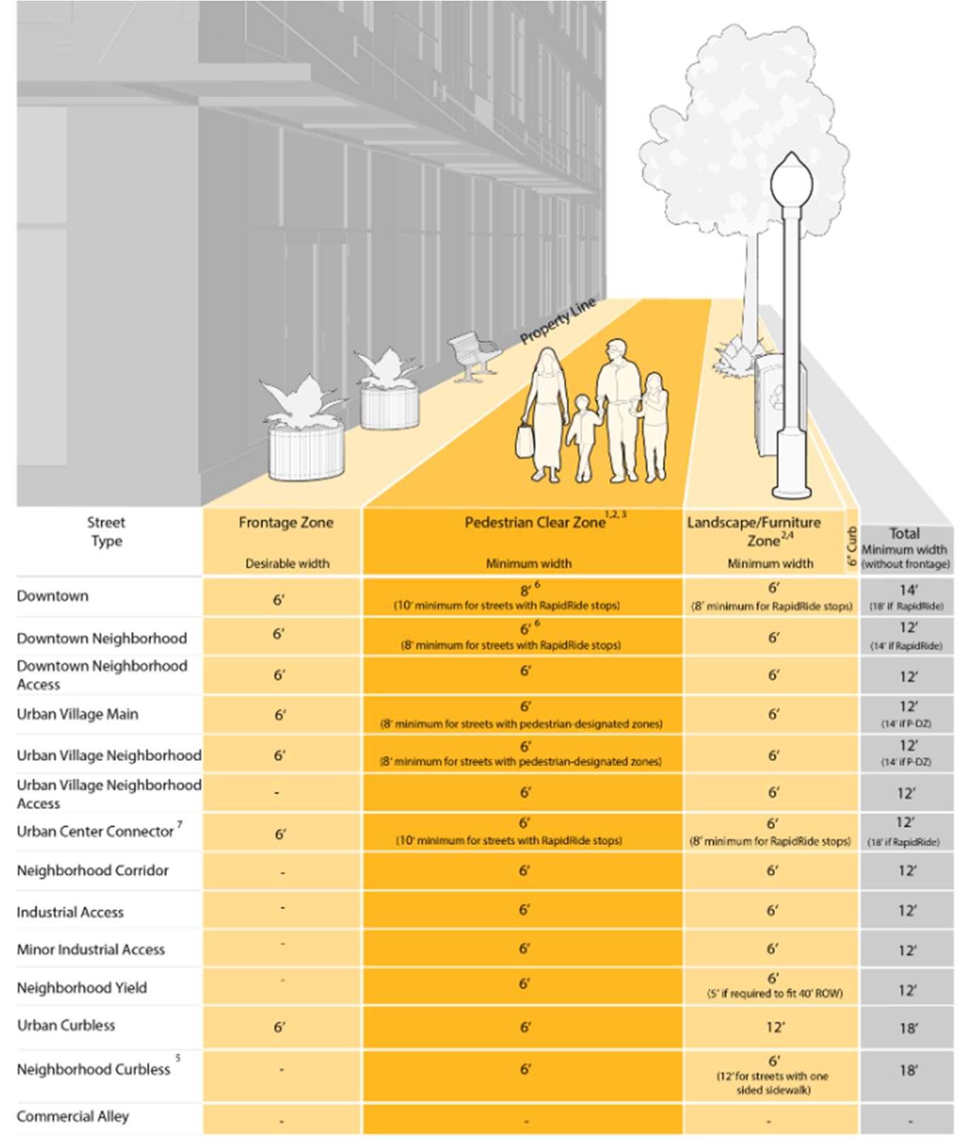
H.3. Recommendation: Establish pedestrian facilities zones such as bike paths, sidewalks, on-street parking,and street furniture within public rights-of-way. Some of the most critical components of a street right-of-way are its accompanying facilities. Streets should not be simply a paved set of travel lanesforvehicularmovement,butaholisticsetofamenitiesandfeaturesthat accommodatemultiplemodesoftransportationandimprovetrafficsafetyas shown in Figure 3-5: Example Pedestrian Facilities Zone - Seattle, WA. Establishing pedestrian facilities zones further Transportation Objective 5 of the 2023 Community Plan: promote active mobility, and alternatives to single-occupant vehicles.
Figure 3-5: Example Pedestrian Facilities Zone - Seattle, WA
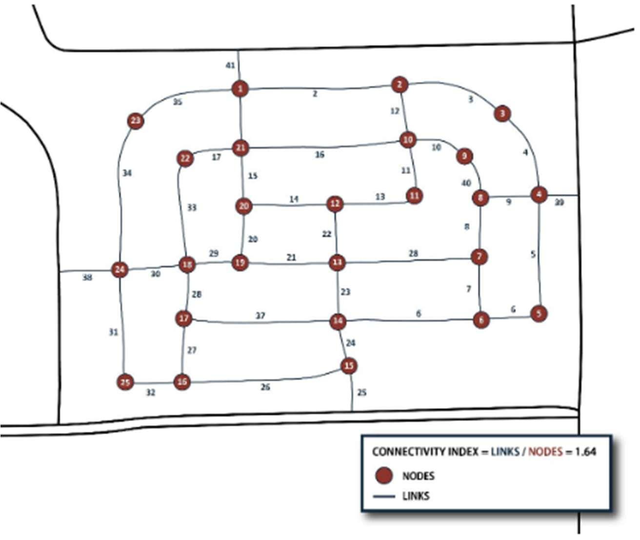
H.4. Recommendation: Provide connectivityregulations, includinga connectivity index, aspart of the subdivision designrequirements.
Connectivity and access management go hand-in-hand. Residential subdivisions should strive to be a place where residents can navigate the neighborhood conveniently and easily engage in city-wide amenities like parks and trails. While the current code regulates street layout in Section 1115.03(b), the code lacks connectivity standards employed by other cities. A connectivity index can indicate the level of connectedness within a subdivision during the platting process as found in Figure 3-6: Example
Connectivity Index - Brownsville, TX. Canal Winchester should consider a similar approach to implementing a connectivity index but should include amenitiesliketrailsandopenspaceascomponentsoftheconnectivityindex equation. Intentionally designed and well-implemented connectivity standards are preferable given the City’s planning policies on enhancing community amenities, improving walkability, and encouraging more accessible neighborhoods.
Shortening the maximum block length is an alternative means of creating more intersections. Currently, new blocks in Canal Winchester can be up to 1,500 feet long. The new Planning and Zoning Code should require shorter blocks and, in turn, improve the pedestrian and vehicular experience. According to the Congress for New Urbanism, shorter blocks reduce traffic fatalities, obesity, and heart disease rates. Whether a connectivity index, shorter block length, or neither is adopted, the new Planning and Zoning Code should work to reduce cul-de-sacs and improve access to new developments.
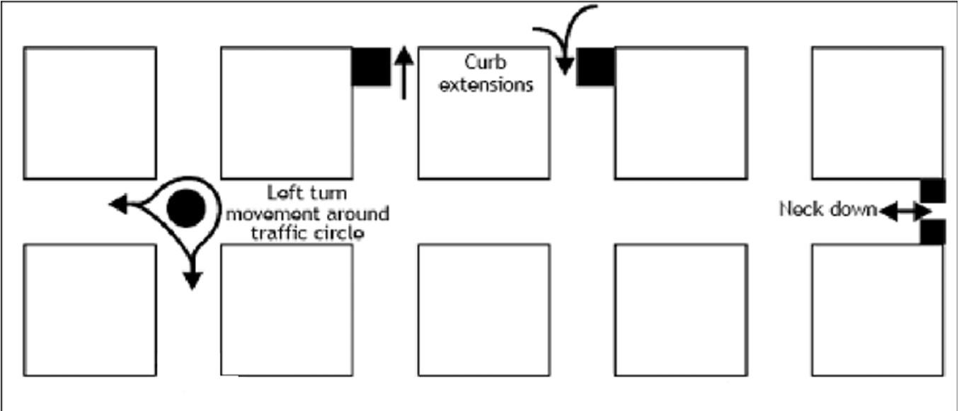
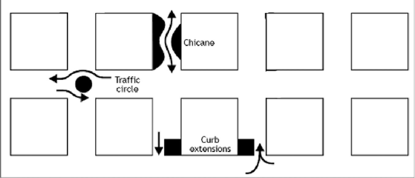
H.5. Recommendation: Require the implementation of traffic calming devices for new street segments to produce safer streets.
The current code encourages the development of long, straight streets within new subdivisions. Especially when subdivisions are new and street trees have yet to reach maturity, such streets encourage higher speeds and detract from safety. As a result, the new Planning and Zoning Code should consider requiring or incentivizing traffic calming devices within new subdivisions.Trafficcalmingdevicesarefeaturesthatreducevehiclespeeds, improve safety, and enhance the pedestrian experience such as chicanes, curb extensions, and traffic circles as seen in Figure 3-7: Traffic Calming Devices. Like with the connectivity index discussed above, a certain ratio of trafficcalmingdevicestonodescouldberequired.Alternatively,travellanes could be made narrower and on-street parking could be encouraged to further slow traffic and improve pedestrian safety. Making streets safer improves the transportation experience of everyone in Canal Winchester by improving safety for drivers, pedestrians, and cyclists. This would advance Transportation Objectives 3 and 4 of the 2023 Community Plan: ensure the design of new and existing facilities lends to a visually appealing environment and maximize the safety and connectivity of the local roadway, respectively.
H.6. Recommendation: Permit through-traffic in new subdivisions to encourage well-connected streets.
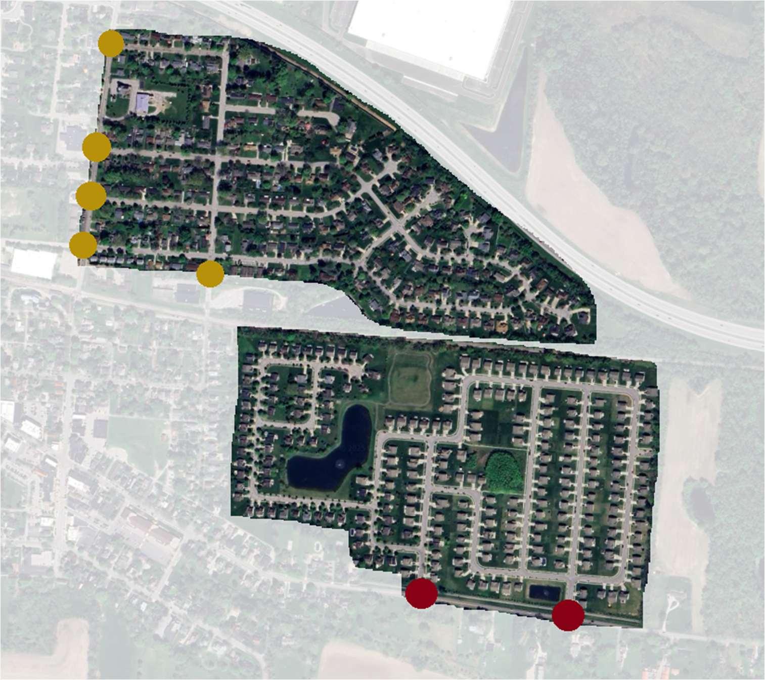
Section 1115.03(b)(3) of the current Planning and ZoningCode discourages the layout of residential streets in a manner that allows for through-traffic. While this type of street layout is commonplace across the United States, it greatly increases the minimumdistancerequired for an individual to leave a subdivision by encouraging fewer points of entry. Furthermore, this development pattern is relatively new in Canal Winchester; newer subdivisions have fewer connections to arterial and collector streets than older developments of a comparable size, as displayed in Figure 3-8: Effect of Limiting Points of Entry. This furthers Transportation Objective 4 of the 2023 Community Plan: maximize the safety and connectivity of the local roadway network.
Figure 3-8: Effect of Limiting Points of Entry. Note that the development to the north has four points of entry, whereas the development to the south has only two points of entry.
Community Plan Objective 4: Incorporate unique and functional community design components with all new developments, public spaces and streetscapes.
Many modern codes pair zoning standards and use permissions with required amenities and site design standards to offset potential drawbacks and encourage positivedevelopmentoutcomes.CanalWinchestercanadvanceitslanduseobjectives by enhancingstandards for landscaping, bike parking, lighting,trashreceptacles, and open spaces. These amenities can transition from mere add-ons to essential elements of community design, fostering a cohesive and uniform aesthetic in public spaces citywide.
I. Observation:Thecurrentlandscapingrequirementslackcontext-sensitivity.
I.1. Recommendation: Create a landscaping and screening matrix to better illustratewhichusesrequirelandscapingandhowsuchrequirementscanbe met.
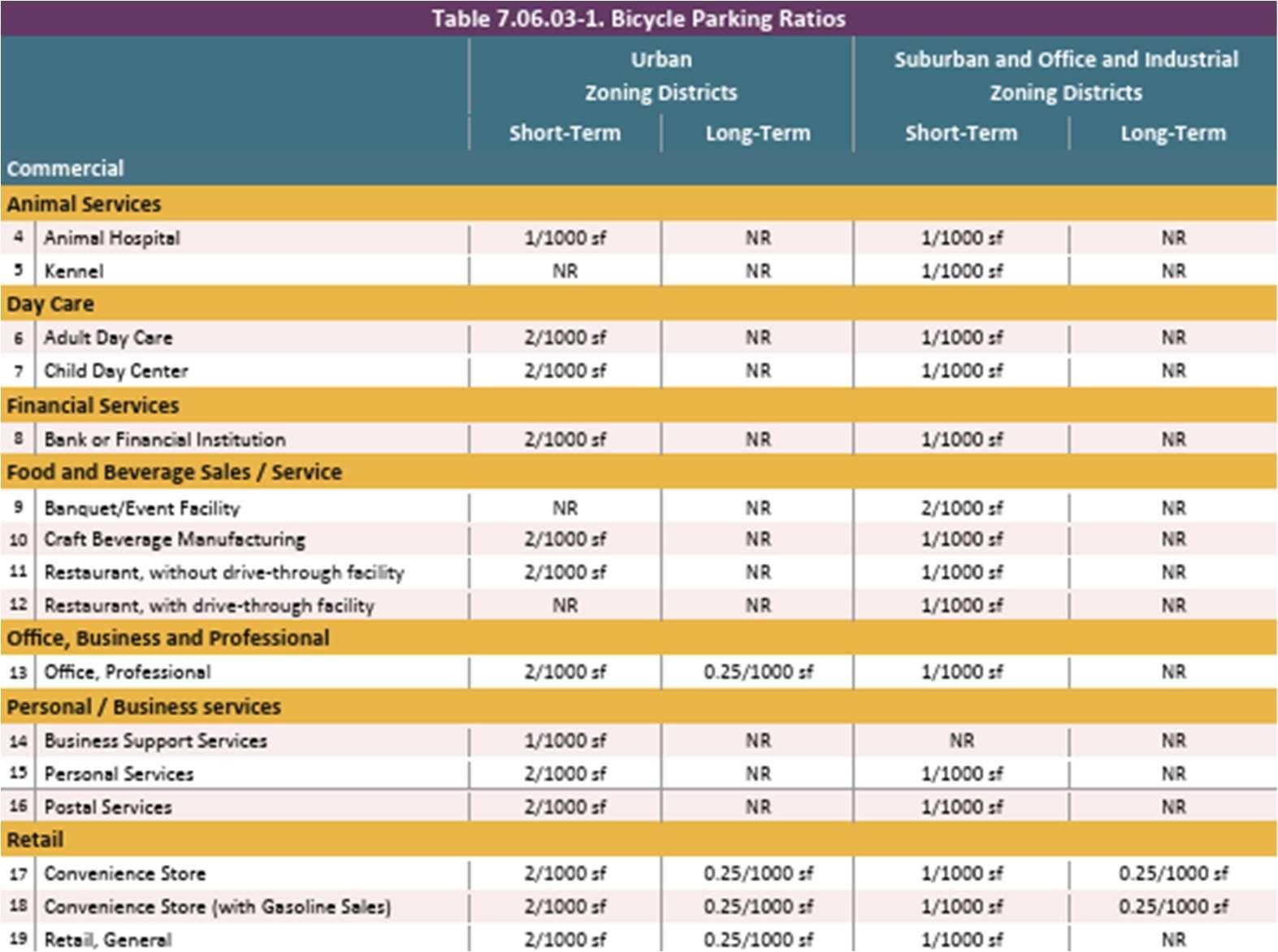
The current code, through Section 1191.05 Development Standards provides landscaping standards for many different uses. However, its organization makes finding the appropriate requirement difficult. Consolidatingthesestandardsintoalandscapingmatrix(similarin formatto Figure 3-10: Example Context-Sensitive Bicycle Parking Ratios - Loudoun County, VA) would makenavigating the landscaping requirements easier.
I.2. Recommendation:Requiretreestobeplantedwithinthepublicright-of-way. ThenewPlanningandZoningcodeshouldrequireacertainnumberoftrees to be planted within the right-of-way for both residential and nonresidential uses. Street trees provide important benefits, including traffic calming, environmental cooling effects, wildlife habitat, noise dampening, general aesthetics, energy savings, and increased privacy. This promotes Transportation Objective 3 and Sustainability Objective 4 of the 2023 Community Plan: ensure the design of new and existing facilities lends to a visually appealing environment and enhance urban tree canopy and woodland preservation efforts to promote sustainable urban ecosystems, mitigate climate change impacts, and improve community well-being, respectively.
I.3. Recommendation: Require tree lawns to be a minimumwidth. Treelawnsaretheareaoflandscapedlandbetweenastreetright-of-wayand a sidewalk. Requiring new sites to include a tree lawn of a certain width enables the planting of street trees and their associated advantages. Lancaster, OH requires tree lawns to be a minimum of 9 feet wide to ensure that street trees are provided with adequate space to grow. A similar
21
regulation could improve the aesthetic quality and safety of Canal Winchester’s streets. Such a standard, however, must be sensitive to the different road types and right-of-way widths to account for traffic demand and utility maintenanceneeds, respectively.
I.4. Recommendation: Require all mechanical equipment to be screened in a context-sensitive manner.
The new Planning and Zoning Code should require screening on at least three sides for all mechanical equipment, including heating, ventilation, air conditioning, generators, and other building systems. Such requirements could preserve aesthetics. Furthermore, drafting standards in a contextsensitive manner would ensure that screening methods are appropriately tailored to each zoning district by requiring materials and designs that are compatible with the primary structuresand surroundingenvironment.
J. Observation: Site design standards lack strong pedestrian access requirements.
The current regulations lack effective stipulations to encourage connections between rights-of-way and building entrances. As a result, some developments in Canal Winchester are accessible effectivelyonly by car.
J.1. Recommendation: Improve site design by providing pedestrian access requirements.
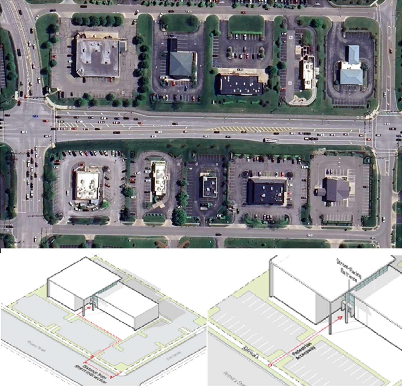
The Planning and Zoning Code should promote a more diverse array of transit options by requiring new developments to include some level of adequate pedestrian access. Charlottesville, Virginia, offers strong, contextsensitive guidelines for connecting entrances to pedestrian paths. Figure 3-9: Comparison of Pedestrian Access - Charlottesville, VA shows a development outcome in Canal Winchester compared to the access requirements set forth in Charlottesville. This standard would improve building and site design in the Regional Commercial/ Office category discussed in the 2023 Community Plan.
Figure 3-9: Comparison of Pedestrian Access - Charlottesville, VA. The upper image is a commercial district in Canal Winchester; the bottom image is pedestrian access guidelines from the Charlottesville, VA, code.
Community Plan Objective 5: Identify gateway locations to target urban design treatments that announce arrival into Canal Winchester.
Thoughtfully designed signs, lighting fixtures, and other public features can welcome residents and visitors to Canal Winchester, reinforcing the city's aesthetic and strengtheningits community identity.
K. Observation:Thecurrentcodelacksdesignstandardsforgatewaycorridors.
ManyvisitorstoCanalWinchestermayonlyexperiencethepartsoftownclosest to the US-33 and Gender Road. The current code does not take advantage of this area’s potential to express Canal Winchester’s small-town, community-centered character. Much of this land is zoned in the General Commercial (GC) District, which provides no design standards beyond the development standards found in Section 1167.04.
K.1. Recommendation: Create gateway enhancement design standards. The new Planning and Zoning Code should consider requiring distinctive entrance signs, coordinated landscaping, harmonious architecture, and adequate street furniture in areas near the US-33, Diley Road/ Busey Road, Washington Street/ Lithopolis Road, and McGillPark areas.
Existing design standards for residential, commercial, and Old Town areas promote cohesive, functional, and visually appealing environments throughout the city. By auditing these standards, ineffective or overly burdensome requirements can be adjusted to better align with Canal Winchester’s development goals.
L. Observation: Commercial building and site designs standards lack contextsensitivity.
The current Planning and Zoning Code provides site design standards for commercial buildings in Chapter 1199 Commercial Development Standards. These standards provide a strong base for commercial development throughout Canal Winchester by regulating site, parking, lighting, and sign design. However, these standards provide little context-sensitivity for different development situations. Without context sensitivity, development can be pushed towards the Planned Commercial District designation, unnecessarily lengthening the development processand weakeningthe force of the new code.
L.1. Recommendation: Create context-sensitive building and site design standards for commercial districts that recognize the different desired development outcomes in each district.
The new Planning and Zoning Code should establish tailored building and site design standards for commercial districts that reflect the desired development outcomes for each zone. These context-sensitive standards would acknowledgethat different commercialzonesservedistinct purposes within the City, from the pedestrian-oriented Old Town Commercial District to the more auto-centric General Commercial District off Gender Road. By creating customized design requirements for elements such as building placement, façade treatments, parking configurations, and landscaping, the new code can ensure development outcomes that enhance existing neighborhood patterns.
M. Observation: Thestandards for projectionsare complicatedandlackcontext sensitivity.
Many houses in Canal Winchester's most desirable neighborhoods contain large porches. Porches foster a sense of community and connection between residents and their surroundings, provide a buffer between private interiors and public streets, and may contribute to the aesthetic appeal of neighborhoods, adding architectural variety and humanizing the streetscape. However, Section 1183.02 Yard Projections limits the design of new porches in the City by only allowing
uncovered porches to extend into required yard areas. While Section 1198.04 includescoveredporchesasanacceptableprojection,thisnonethelesspresentsa contradiction in the code that should be clarified. By limiting the types of porches covered by thisexception,many housesinclude noporches at all.
M.1. Recommendation: Permit porchesto project into therequired front yards.
The new code should permit covered porches to project into the required front yard area in order to create more inviting streets, prioritize human connection, and enhance walkability. If the City wants to promote porches to a greater extent, front porches at least 4 feet wide in all or some residential zoning districts. If such an approach is undertaken, measuring existing porches could provide important dimensional standards for future porches.
N. Observation: Design guidelines encourage varying design without concern foraestheticquality.
The current code provides design standards for residential areas in Section 1198 Residential Appearance Standards. These standards require that neighborhoods are designed in a manner that promotes safety and encourages a strong sense of community. However, there are instances where the guidelines focus more on diversity of design than quality of design.
N.1. Recommendation: Replace the required change in materials used for construction with a minimum percentage of high-quality materials like masonry.
To encourage architectural variation, Section 1198.04 Residential Design Requirementsencouragesthe“Changeinmaterialofsignificantproportions (40%) of the house façade.” Different materials are beneficial to the design of a building; however, variation for variation’s sake can create unsightly results. Two materials are better than one, but six are not necessarily better than five. Furthermore, requiring variation in the design of individual structures does not discourage the development of monotonous neighborhoods with identical architecture. The new Planning and Zoning Code should reevaluate this provision to provide a new standard that incentivizesstrong, varying design. This standard could look likeaminimum percentageofthefaçadethatmustbe constructedofhigh-qualitymaterials, such as masonry, that promote sustainability and enhance the visual appeal of buildingswithin neighborhoods.
Additionally, the new Planning and Zoning Code could encourage high qualitydesignbyrequiring“heavierappearing”materialssuchasstoneclose to the ground, with lighter, siding materials onmiddle and upperlevels.
N.2. Recommendation: Allow residential developments to include only sideloaded garages.
Section 1198.01(a)(3) states a goal of Canal Winchester’s residential appearance standards to limit “the garage appearance within the front elevation [to] limit thenegative impact.” Thisstatement is then counteracted in Section 1198.04(a)(8): “All single-family residential developments shall havea mixof frontloadedandsideloaded garages.”Whilevarietyisusually good, requiring a mix of front-loaded and side-loaded garages effectively requires a certain percentage of garages to be front-loaded, thereby requiring the negative impacts of garages on the front elevation deemed undesirable in 1198.01(a)(3). Removing the requirement for residential developmentsto include both front-loaded and side-loaded garages would allowdevelopmentstoreducegarages’negativeimpactsontheappearance of residential areas without preventing the front-loaded garages where desirable. One way to reduce the negative impacts of front-loaded garages is to require the garage door be set back fromthe building façade.
O. ThePlanningandZoningCodelacksdesignstandardsforindustrialuses.
While the code provides clear and detailed design standards for residential and commercial uses, it remains silent on the design of industrial developments. This lack of guidance can lead to inconsistencies in site planning, building aesthetics, landscaping, and compatibility with surrounding land uses. Without established design criteria, industrial projects may fail to address important considerations such as buffering from residential areas, integration with transportation infrastructure, environmental sustainability, or visualimpact.
O.1. Create Industrial Design Standards to be integrated with theLM District. Integrating Industrial Design Standards into the LM District will ensure industrial projects are visually cohesive, functional, and compatible with surroundingareas.Thissolutionpromoteshigher-qualitydevelopmentwhile providing clarity for both developers and the community.
P. Observation:Thereisambiguityinthe2012OldTownDesignGuidelines.
The standards in the 2012 Old Town Design Guidelines are not prescriptive enoughtoensurethatthehistoricandarchitecturalcharacteristicsoftheOldTown are preserved. While the guidelines provide a strong explanation of acceptable building types and design features, its standards can be vague and difficult to understand.
P.1. Recommendation: Create Old Town Design Standards within the new Planning and Zoning Code.
Creating Old Town Design Standards within the new Planning and Zoning Code will make the regulations controlling development in the Old Town easiertofindandunderstand.Furthermore,movingtheseregulationscould
allow for the review of any unnecessary, redundant, or vague language, whichcould then be altered or removed as necessary.
General Planning Best Practice 1: Zoning should regulate only what needs to be regulated in order to protect the public health, safety, and welfare.
When regulations exceed their purpose of protecting health, safety, and welfare, they can create inequalities, hinder economic growth, or, worse, become unlawful. To remain effective and legally defensible, zoning ordinances should avoid unnecessary restrictions and should maintain alignment with the Community Plan’s goals.
Q. Observation: The Planning and Zoning Code includes occasional inconsistencieswiththeOhioRevisedCode.
Canal Winchester’s Planning and Zoning Code has a few instances where definitionsarenot adequately aligned with state law.
Q.1. Recommendation: Align all terms with any recent changes to the Ohio Revised Code.
The new Planning and Zoning Code should address any inconsistencies between the existing code and the Ohio Revised Code and any other State regulationsthat addressdevelopment.
Q.2. Recommendation: Update the subdivision regulations to reflect changes in the caselaw.
As a result of Wesolowski v. Broadview Heights Planning Commission, 2019 Ohio 3713, Canal Winchester’s subdivision procedures are likely subject to legal challenges. The code affords the Planning and Zoning Commission 35 daystodecideonasubdivisionplanandanother35daystodecideonafinal plat. However, both of these decisions should now be made within a 30 day period. Updating the administrative procedure for subdivision approval would help bring the code closer to alignment with the Ohio Revised Code.
R. Observation: The Planning and Zoning Code frequently regulates religious landuses.
Thecurrentcodepermits“churchesandothersimilarplacesofworshipandparish houses” as conditional usesin the R-1, R-3, MF-A, MF-C, and SO Districts. As such, religious uses are regulated by lot size, lot width, off-street parking, and traffic connection requirementsthat do not applyto similar uses.
R.1. Recommendation: Limit regulations on religious land use to only those standards that are necessary.
The new Planning and Zoning Code should employ the simplest possible framework to regulate religious land use so as to not treat such uses as different from any other use that constitutes the assembly of small or large groupsofpeoplewithinaconfinedarea,bettercomplyingwiththeReligious
and Institutionalized Persons Act (RLUIPA). Ideally, the Planning and Zoning Code would only regulate where religious land uses may operate. For example, these uses might be allowed by-right in all residential districts and prohibited in the GC and LM Districts.
S. Observation: The layout of zoning districts interferes with desired developmentoutcomes.
S.1. Recommendation: Simplify the subdistricts found in the Multi-Family Residential District.
The current code does a good job limiting the overall number of zoning districts. However, within the Multi-Family Zoning Districts, the use of subdistricts adds complication to the code. The code could be clarified and theuserexperienceimprovedbyreorganizingorsimplifyingthesubdistricts within the code. For example, the MF-A and MF-C have identical standards other than the distinction between apartment units and condominium units. This might be a useful distinction to make between uses; however, it is unnecessary to limit apartments to one district and condominiums to another. Instead, these districts should be consolidated into one multi-unit residential district.
S.2. Recommendation: Refine the use of overlay districts.
Thecurrentcodeprovidesfouroverlaydistricts:theOldTownOverlay,Violet Pointe Overlay, Adult Entertainment Facilities, and Stream Corridor Protection Zone Districts. These districts should be refined to not duplicate other districts. For example, the Old Town Overlay District accomplishes many of the same goals as the Old Town Single Family, Old Town MultiFamily, and Old Town Commercial Zoning Districts. As such, the standards foundintheOldTownOverlaycouldbemovedtoaconsolidatedOldTown ZoningDistrict(abasedistrict).Meanwhile,theAdultEntertainmentFacilities Districtisanimportantcomponent ofensuringCanalWinchesterremainsan attractive place for families; however, creating an overlay district for these uses is unnecessary. Instead, these uses could be subject to the exceptional usepermit.However,someoverlaydistricts,suchastheOldTownandViolet Pointe Overlay Districts, should be carried forward.
S.3. Recommendation: Refine the use of the Exceptional Use District.
The current Planning and Zoning Code places any use incompatible or unaddressed by the rest of the code in the Exceptional Use District. The conceptofprovidingspecialreviewforunordinaryusesiscommonplaceand beneficialtothecode;however,accomplishingthisthroughaspecialzoning district can add confusion, complicate the code, and slow the development process. Reconsidering when and how the Exceptional Use District is employed could allow the City to provide increased development opportunities without forfeiting the control afforded to the City by the ExceptionalUseDistrict’sexistence.
General Planning Best Practice 3: Zoning should be the implementation of a plan, not a barrier to achieving the community vision.
T. Observation: The Planning and Zoning Code requires lengthy approval processes.
T.1. Recommendation: Expand opportunities for staff-level approval of development applications.
Thenewcodeshouldclarifyregulationsandsetwell-definedparametersthat empower staff to evaluate the conformity of simple proposals with the regulations of the code. Allowing staff to make decisions can expedite the development process, improve staff confidence, ensure a fair development process, and reducetaxpayer spending.
U. Observation: Density requirements create barriers to higher-intensity development.
Although regulating density is a common practice, it is one that is becoming increasinglyoutdated.Densityhasbeenatopicofconcernformanysuburbanand rural communities, but low development densities may strain a community’s infrastructure and place a greater tax burden on its residents.
U.1. Recommendation: Remove density requirements and allow the lot dimensional standards to regulatedensity.
U.2. Recommendation:Increasethemaximumdensityallowedfortheconversion of nonresidential uses to dwellings.
Section 1153.03 Conversion to Dwellings provides an important regulatory tool for encouraging the development of housing options across Canal Winchester. However, the current requirement that all conversions are subjecttothesamelot,yard,anddensityrequirementsasnewconstructions could present development challenges. The standards for conversions to dwellings would ideally allow more permissive standards, such as greater density, that encourage thereuseof existing buildings within the City.
V. Observation:Thecoderequireslengthyconditionalusepermitapprovals.
The current code requires conditional use approval for too many uses. For example, the R-1 District allows four uses by right but an additional eight through conditional use approval while the NC District allows only three uses by right but an additional 11 throughconditional use approval.
V.1. Recommendation: Reduce the number of uses that require conditional use permits and provide alternatives.
Asanalternativetotheoveruseofconditional usepermits,thePlanningand Zoning Code should find ways to reduce administrative hearings by implementing use-specific standards and staff-level approvals where appropriate.However,thisshouldbedonecarefullyandthecodeshouldnot eliminate the conditional uses altogether as they can provide a medium between permitting a useby-right and prohibiting a use.
W. Observation:SiteDevelopmentPlansarerequiredfortoomanyuses.
Site Development Planscan beusefultools toensurethatdevelopmentsmeetthe City’slandusestandardsbeforeconstructionbegins.However,theycanalsopose barriers to development by introducing detailed approvals for issues like zoning, environmentalimpact,andinfrastructurethatcanbetime-consumingandcostlyto navigate. These barriers can discourage investment and hinder timely project completion, especially for smaller developers. Evaluating whether the current Site Development Plan process furthers the goals of the Community Plan is important to assessing the tool’s success.
W.1. Recommendation: Expand exceptionsfound in Section 1141.02(b)(1).
The current code requires Site Development Plans for all new construction, reconstruction, and expansions “except for single-family detached dwelling units, duplexes, or accessory structures in residential districts.” This requirement is good because it encourages the construction of housing by allowing more one- and two-unit dwellingsto be built without theburden of Site Development Plan approval. However, this exception could be expanded to include triplexes, quadplexes, and small-format mixed-use buildings to further promote the development of these building types in Canal Winchester.
W.2. Recommendation: Increase the maximum floor area allowed for minor site plan approval.
One way to decrease the number of developments hindered by the Site Development Plan approval process is to increase the maximum number of gross floor area allowed for a Minor Site Plan. Minor Site Plans differ from MajorSitePlansinthatthePlanningandZoningAdministratorreviewsMinor Site Plans while the Planning and Zoning Commission reviews Major Site Plats. By shifting the decision-making authority to the Planning and Zoning Administrator,theMinorSitePlanprocessis moreefficientandposeslessof a barrier to development. The new Planning and Zoning Code should increase the maximum gross floor area that qualifies for Minor Site Plan review, allowing more development to receive approval without going in front of the Planningand Zoning Commission.
W.3. Recommendation: Provide exemptions from environmental analysis requirementsfor sites under a certain size. While environmental regulations provide necessary protections, these regulations can also pose barriers to development. The Environmental Analysis requirement stipulated in Section 1141.12 Environmental Analysis ensures that nearby slopes and wetlands are not adversely impacted by construction in Canal Winchester. However, unlike Site Development Plans, the environmental analysis requirement provides no relief for site under a certain size. This poses a barrier to smaller development by requiring expensive surveying before construction can begin. Furthermore, many of the goals advocated for by the environmental analysis requirement are standardsenforcedbytheStateofOhioandfederalgovernments.Providing an exemption from this requirement for small sites would help promote development inCanal Winchester.
General Planning Best Practice 4: Achieving equity, resiliency, and sustainability should be cornerstones of any code update.
X. Observation: The Planning and Zoning Code lacks alternative transportation considerations.
X.1. Recommendation: Implement bicycle parking requirements applicable to certain development contexts, such as the Old Town.
Similar to Loudoun County, VA, as seen in Figure 3-10: Example ContextSensitive Bicycle Parking Ratios - Loudoun County, VA, Canal Winchester should expand parking regulations to include bicycle facilities in mixed-use districts and areas where the Future Land Use Plan determines such developmentsdesirable.
Additionally, the new Planning and Zoning Code should also implement robuststandardsandspecificationstoensurethatbicycleparkingisnotonly provided but accommodated in an aesthetically appealing manner through design requirements. Manhattan, Kansas offers a variety of structural, locational, and access standards that regulate bicycle parking and its associatedfacilitiesintheirzoningcode.Theserequirementsalsoencourage amenities such asstorage lockers.
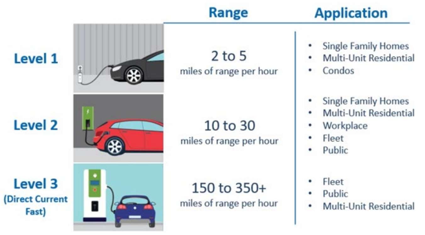
Y. Observation: The current electric vehicle charging stations regulations are outdated.
In the last decade, electric vehicles (EVs) have grown in popularity. As such, EV charging stations have become critical for ensuring safe, accessible, and efficient infrastructure that meets this growing demand. Canal Winchester last updated its EV charging station regulations in2012.
Y.1. Recommendation: Update theelectric vehiclecharging station regulations. The new Planning and Zoning Code should provide new guidelines that are consistent with modern EV charging stations, making sure that the requirements are permissive enough to ensure the construction of the necessary number of EV charging stations. For example, Section 1181.09(c)(2) currently requires additional screening for a group of five or more EV charging stations on a residential property. Because many EV charging stations are inconspicuous, this regulation could be removed or couldbereworkedto alignthescreeningor bufferrequirementwiththatfor parking on residential lots in general. Additionally, graphics such asthe one seen in Figure 3-11: Example EV Charging Station Graphic - Bucks County, PA could help illustrate the definition of an EV charging station and explain the requirements of thissection.
3-11: Example EV Charging Station Graphic - Bucks County, PA
Z. Observation: The lack of renewable energy regulations may inhibit the developmentofwell-designedgreenenergyinfrastructure.
Z.1. Recommendation: Regulate solar and geothermal energy systems to encouragetheir proliferation.
AA.Observation: The current code includes information in difficult-to-find locations.
The Planningand Zoning Code’s multiple-article structure has significant room for organizational improvement.
AA.1.Recommendation: Modernize the Planning and Zoning Code's organizational structure to adhere to contemporary best practices.
AA.2.Recommendation: Locate high-priority content near the beginning of the code.
The new Planning and Zoning Code should place the most pertinent informationupfronttoimprove theeaseand quickness ofuse.This prevents code users from having to spend considerable time searching for important information.
BB.Observation: The Planning and Zoning Code contains outdated terms, complexlanguage,vaguemeasurements,andgenderedlanguage.
ThecurrentZoningandSubdivisionOrdinancescontaintechnicalandlegaljargon that lengthens the document’s text, such as “thereby,” “hereto,” “hereafter,” and “hereinafter,”whichelongatesentencesandmakethemdifficulttounderstand.An auditfoundatleast176vaguetermsandatleast356“legalese”termsinthecurrent Planning and Zoning Ordinanceas seen in
Table 3-1: Vague Term Audit and Table 3-2: Legal Jargon Audit , respectively. Additionally, the code contains numerous instances of explicitly gendered terms suchas “his obligation” and “hismeasurement.”
Table 3-1: Vague Term Audit
8
BB.1. Recommendation: Clarify all vaguelanguage.
BB.2. Recommendation: Replace outdated terminology and gendered language to reflect contemporary best practices.
The new Planning and Zoning Code should always use a title or position when referring to authority. So, instead of reading “his decision,” the new code might read “the PlanningAdministrator’sdecision.”
BB.3. Recommendation:ReducelegaljargonanduseplainEnglishtoimprovethe code userexperience.
The terms in Table 6-2: Legal Jargon Audit should be converted into plain English to improve readability and code comprehension. For example, “hereafter” could be replaced with the phrase “from this point forward,” providingaclearerstatementofthelanguage’sintent.ByusingplainEnglish, the code will be easier for the average code user to understand and, therefore, morereflectiveof a democratic governancesystem.
CC.Observation: Graphics are used sparingly and are difficult to understand whenused.
The current Zoning and Subdivision Ordinances utilizeonly a handful of graphics.
CC.1.Recommendation: Use reference images, graphics, or diagrams to depict dimensional and design requirements when appropriate.
DD. Observation:Proceduralinformationisdifficulttounderstand.
DD.1.Recommendation: Create a new chapter forall procedural information.
While Title Three Zoning Administration currently houses all the code’s procedural information, this information may be difficult for code users and administrators to locate. Creating a centralized chapter for all procedural information would make the code more user-friendly and allow for a more consistent display of important information.
DD.2.Recommendation:Mapeachdevelopmentprocesswithanewly-established common procedural format.
The current Planning and ZoningCode doesa good job at using a relatively similar format when establishing procedures. However, by following a uniform layout for each process, the development process can become easier to follow all code users. Each development application or process should have subsections that address the questions found in Table 3-3: Questions to be Answered by Common Procedural Format below. Answering these questions is a necessary feature that improves code, transparency, readability, and usability.
Table 3-3: Questions to be Answered by Common Procedural Format
Initiation
Completeness
Notice and Hearing
Action
How and to whom is an application submitted?
What is required when an application is readytoprocess?
What noticing requirements apply to a development application? Are there any publichearingrequired?Ifso,howmany?
Who reviews, recommends, and makes decisions?Howaredecisionsmade?
Standards
Subsequent Applications
Appeals
Scope of Approval
Recordation
What specific standards or criteria apply totheapplication?
Ifanapplicantwithdrawsorisdenied,can they file a new application? When can a newapplicationbefiled?
Who and how can an applicant appeal a decision?
What does this approval allow the applicant to do? What is the next step in theprocess?
Who records the final document and wherecanitbefound?
DD.3.Recommendation:Improveclarityofproceduralflowchartstobetterdisplay otherwise complicated proceduralinformation.
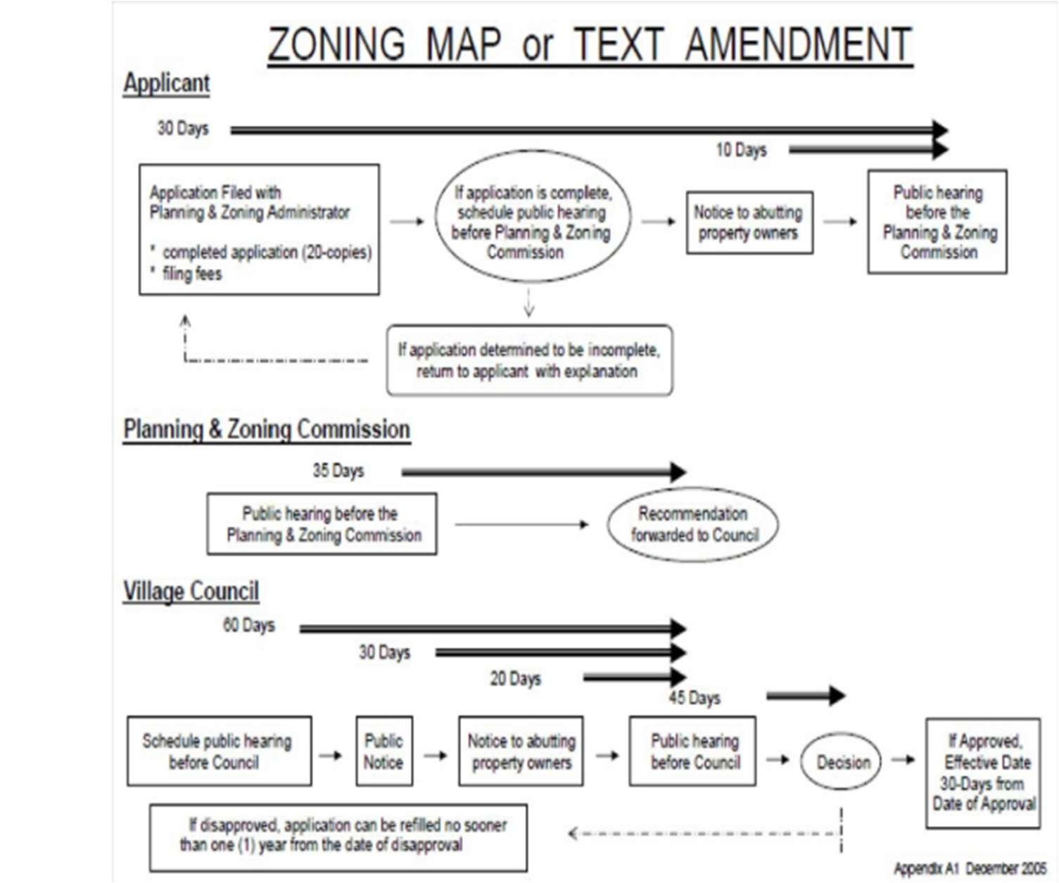
The current code contains graphics in Appendix A that display important procedural information in a user-friendly manner as seen in Figure 3-12: ExistingProceduralInformationGraphic.Thenewcodeshouldupdatethese graphicsand locate such graphics in a new procedural information chapter.
Figure 3-12: Existing Procedural Information Graphic
EE. Observation: The purpose, roles, and responsibilities of the approval bodies areunclear.
ThePlanningandZoningCommission,ZoningBoardofAppeals,andCityCouncil each have distinct functions that contribute to the overall framework of land use regulation.Their roles are not clearly defined.
EE.1. Recommendation: Map each approval body with a newly established, common format.
While the current Planning and Zoning Code addresses who acts on each development application, the code can be improved by providing an authority summary table as seen in Figure 3-13: Example Approval Body Summary - Dublin, OH. This table can provide clarity to the user regarding who reviews and acts on a specific application without sifting through each developmentapplicationprocedure.Thecommonunderstandingisthatthe City staff, Planning and Zoning Commission, and City Council play critical roles in the development process by making recommendations and approving the numerous development applications. Since these bodies are frequently involved with the development process, it is imperative that the code user knows how these bodies interact with the development process without wasting timecombing throughthe code’stext.
FF. Observation: Definitions are located throughout the Planning and Zoning Code,makingthemdifficulttofind.
In the current code, definitions for the subdivision regulations are largely found in Chapter 1103 Definitions, while those for the zoning regulations are found in Chapter 1133 Definitions. However, there remain instances where definitions are found outside of the definition article. For example, Chapter 1193 Wireless CommunicationFacilitiesincludesitsownsetofdefinitions.Thiscanaddconfusion about wheredefinitionscan be found, and which terms have official definitions.
FF.1. Recommendation: Create an article at the end of the code exclusively for definitions,acronyms, and commonly used phrases.
While it can seem appealing to have definitions in locations where a term is applicable,itisbestpracticetolocatealldefinitionsinthesamearticleatthe end of the code.
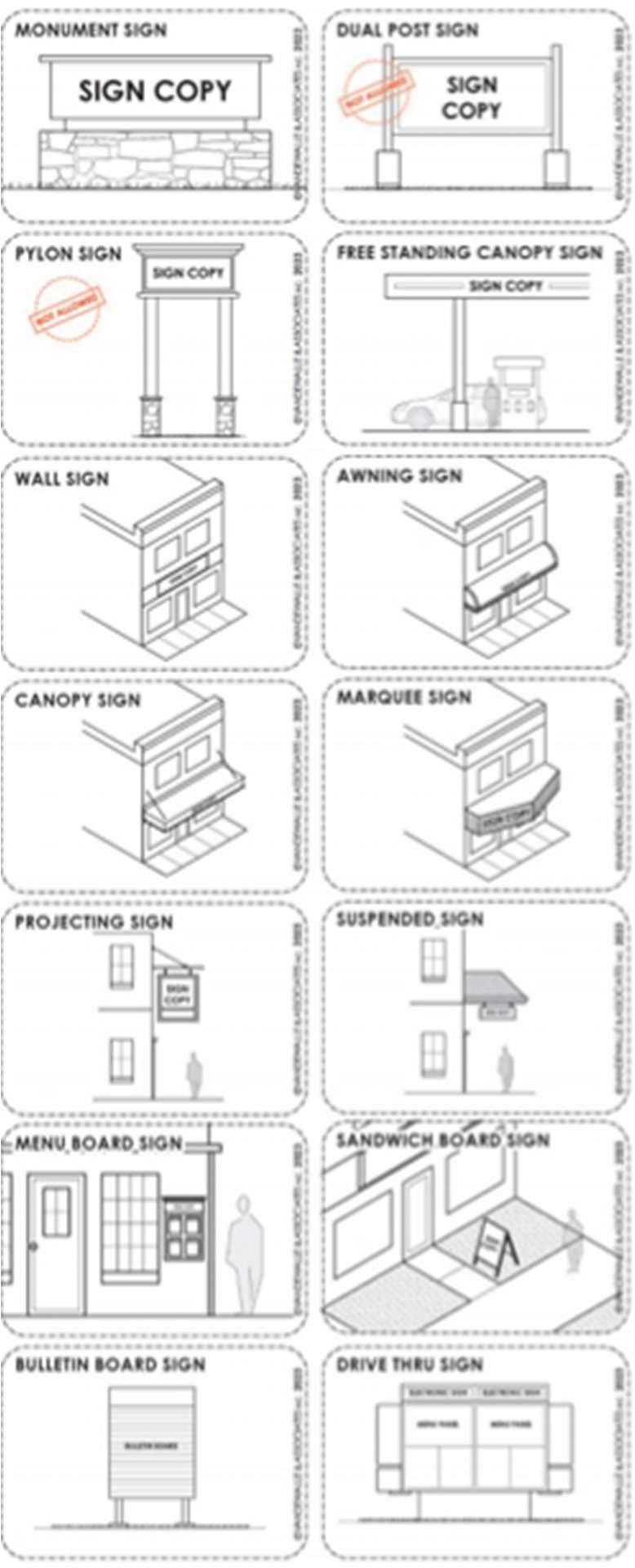
GG. Observation:Signstandardsaredifficulttounderstand.
GG.1.Recommendation: Provide graphics for sign types and measurements. The current Zoning Ordinance relies entirely on text to describe each sign type. While the current language is straightforward, graphics can improve code users’ abilities to identify which sign types apply. Middleton, WI offers an example of how sign diagrams can provide useful aids to a sign code as seenin Figure 3-14: Example Sign Diagrams- Middleton, WI.
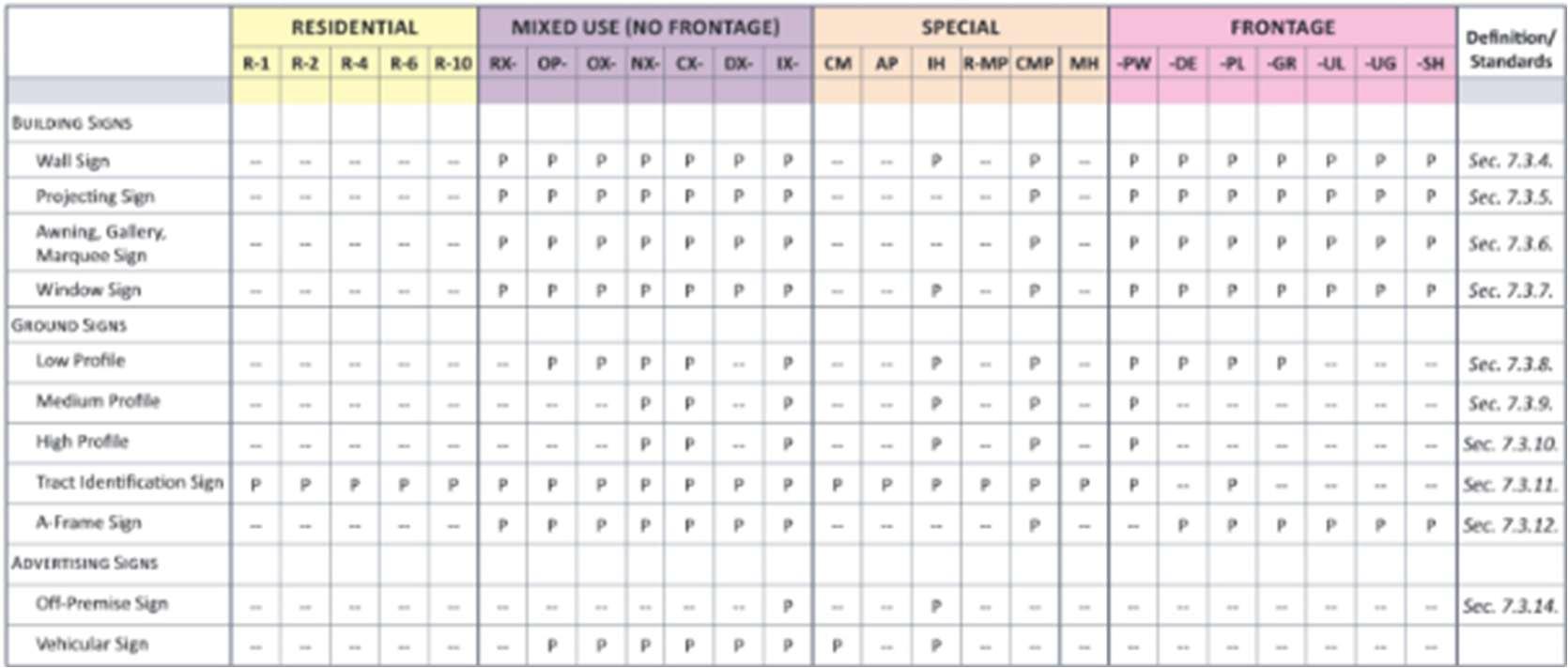
GG.2.Recommendation: Organize sign standards into a comprehensive table. The current Zoning Ordinance includes tables that summarize sign allowances through text-heavy regulations located in Chapter 1189 Signs. Thisapproach complicates finding usefulinformation such as thenumber of signs allowed per use, the dimensional requirements for said sign, and the illumination standard for signs in the district. These tables can be expanded and improved to show which sign types are allowed by district in a more understandable format. An example of simplified sign tables can be seen in Figure 3-15: Example Sign Typology and District Allowances - Raleigh, NC
where sign allowances by district are summarized at the beginning of the signregulations.
Figure 3-15: Example Sign Typology and District Allowances - Raleigh, NC
HH.Observation:Informationabouthowmeasurementsarecalculatedisdifficult tofind.
The current Planning and Zoning Code lacks a centralized chapter that defines a fairandconsistentmethodologytomeasuringlotarea,buildingheights,setbacks, etc.
HH.1.Recommendation: Create a sectiondedicated to measurements. Like with definitions, measurements should contain their own section where all measurements are described to prevent ambiguity and confusion. This section should be complete with instructions that explain how to measure variouscomponentsandgraphicsthatdisplaywhatcertaincomponentslook like. Providing this level of clarity will help ensure that all code users understand how to comply with the new Planning and Zoning Code’s regulations.
HH.2.Recommendation: Remove unnecessary and difficult-to-understand measurements.
Forexample,Section1183.04AssignedYardsforArrangementofStructures introduces an alternative measurement referred to as an “assigned yard.” Whiletheapplicabilityofthemeasurementisclear,themannerofmeasuring an assigned yard is complicated and confusing. Difficult-to-understand measurementslikethesecanpreventastandardorexceptionfromproviding its desired effect. Ensuring that all measurements included in the new Planning and Zoning Code are easy to understand will augment the new code’s ability to promote desired development outcomes in Canal Winchester.
II. Observation: The notification of hearing procedure for subdivision approval isoutdated.
WhiletheCityupdateditsnotificationofhearingrequirementsin2023toallowfor hearing notices to be posted on official website of the City of Canal Winchester, some parts of the code still require the old practice for public notification. Section 1105.03 Variances by the Planning and Zoning Commission still require the notification of public hearing to be given “at least ten (10) days prior to the public hearinginoneormorenewspapersofgeneralcirculationinthemunicipality.”This practice isout of touchwith the rest of thecode’spolicy for publicnotification.
II.1. Recommendation: Update the notification of hearing procedure for subdivisionapprovaltomatchthenotificationstandardsfoundinthezoning regulations.
Ensuringtheentirecodemaintainsauniformstandardforpublicnotification allows citizensto be sure of wheresuch notificationscan be located. If some notifications are posted in the newspaper while others are posted on the City’s website, property owners could miss a notification and lose their opportunity to participate in local government. Furthermore, resolving this discrepancy will make the development process clearer and, in turn, more efficient.
The current Planning and Zoning Codes, while containing some valuable provisions, largely fall short of supporting the City's evolving planning goals and objectives, necessitating comprehensive updates across most sections. Significant revisions are needed to align regulations with contemporary urban design principles, sustainability standards, and community development priorities that have emerged since the original code's adoption. A thoughtful reorganization of the code structure would greatlyimproveusabilityfordevelopers,propertyowners,andcitystaffalike,replacing technical jargon with clear language and incorporating visual aids such as diagrams, charts, and illustrations to clarify complex requirements. By restructuring content logically, rewriting provisions in plain language, and adding visual guide, the new Planning and Zoning Code will not only become more accessible and easier to interpret but will also foster higher quality development outcomes that better reflect the community'svision for growth and preservation.