BARRIERS AND BRIDGES
Danville Code
Diagnostic Report

4.4.2
5.2.1
Danville Code
Diagnostic Report
4.4.2
5.2.1
Nothing contained in this document shall be deemed or considered to be legal advice. Although some ZoneCo professionals are also attorneys who may be separately engaged to provide legal representation in states where we are licensed to practice law, ZoneCo is not a law firm. ZoneCo professionals do not provide legal representation or services and are not engaged in the practice of law in any jurisdiction. Engaging ZoneCo does not form an attorney-client relationship and, as such, the protections of the attorney-client relationship do not apply. If you wish to create an attorney-client relationship, you are encouraged to contact an attorney of your choosing.
The development of this Diagnostic Report is the first step in rewriting the Zoning and Subdivision Ordinances of the City of Danville, VA. This report evaluates the Zoning and Subdivision Ordinances in its ability to achieve the community’s objectives as stated in the Comprehensive Plan and meet regional and national best planning practices. Danville’s long-range planning efforts have been active since the start of the millennium. The consultant team reviewed several other long-range plans, studies, and projects that affect this rewrite project. However, the primary focus of this document is to understand the efficiencies and deficiencies of the current Zoning and Subdivision Ordinances pertaining to the Comprehensive Plan and best planning practices.
While the Diagnostic Report and Zoning and Subdivision Ordinances further the objectives identified in the Comprehensive Plan, all are distinct documents. The Comprehensive Plan was the result of a robust, longrange planning process involving community engagement, visioning, and goal setting. The Comprehensive Plan was adopted by the local legislative body; however, it functions as a high-level roadmap to guide future development decision-making. The Zoning and Subdivision Ordinances, in contrast, are legally binding documents that dictate planning, land use, and development regulations. This Diagnostic Report functions as a critical bridge between the Comprehensive Plan’s long-term vision and the legal framework of the Zoning and Subdivision Ordinances.
This report was produced by a team of unbiased professionals through review of existing adopted plans, policies, and regulations. Professionals working on this report used the Comprehensive Plan, professional expertise in the planning discipline, experience working with peer cities, and familiarity with national best practices to evaluate the Danville Zoning and Subdivision Ordinances and generate recommended revisions or areas for additional analysis.
Located on the banks of the Dan River, Danville dates to the 18th century when settlers were drawn to the area’s fertile land and access to waterways. Officially established in 1793, Danville quickly became an important center for trade and transportation, particularly due to its location along the river, which facilitated commerce in tobacco and textiles. The city's growth accelerated with the arrival of the Richmond and Danville Railroad in the mid-19th century, further solidifying its status as a key economic hub in the region. During the Civil War, Danville played a significant economic and political role for the Confederacy as a supply depot and temporary, final capital.
Following the war and throughout the 20th century, the city's textile manufacturing and tobacco warehouse jobs provided stable income for many residents. However, as these industries declined in the late 20th century, Danville faced economic challenges and a period of transition. In response to changing conditions, the city actively engaged in long-term planning, guided by its comprehensive plans, which are reviewed and revised every five years. Since the last comprehensive plan in 2015, Danville’s circumstances have been impacted by a variety of developments, including a global pandemic, economic uncertainty, renewed recognition of systemic inequality, and multiple floods along the Dan River. At the same time, the city has experienced an economic boost from the construction of Caesars Casino and the investment of federal grants for infrastructure improvements. Recognizing the need for a renewed and
focused approach, the City of Danville launched comprehensive planning process in 2023, a collaborative effort laying the groundwork for future generations to thrive while preserving its rich history and small -town charm.
In recent years, Danville has engaged in meaningful planning efforts on multiple occasions. These efforts each produced plans that provide values, intentions, and goals for the future of the community. For the purposes of producing a new Zoning and Subdivision Ordinances, these plans should be understood as complimentary documents that establish the government’s interest in policy-making. Each change to the Zoning and Subdivision Ordinances should advance one or more of the goals laid out in these plans.
The Danville Comprehensive Plan, A Comprehensive Plan for a Unified Future, is the city’s long-range guide for growth and development, providing a strategic vision for Danville’s future. The plan outlines a broad range of policy areas, including land use, economic development, housing, transportation, community character, public services, and natural and cultural resources. Through extensive community input and analysis, it establishes a clear set of goals and priorities to shape the city’s future, focusing on fostering sustainable growth, enhancing quality of life, and preserving Danville’s unique identity. The key land use objectives include the following.
2.2.1
Danville residents are connected to and proud of their neighborhoods with many preferring the preservation and revitalization of Danville’s existing neighborhoods over the demolition of existing buildings and new construction Updating the Zoning and Subdivision Ordinances to provide more flexibility and reduce barriers to development can help spur these preferred development patterns. Furthermore, the Zoning and Subdivision Ordinances should promote neighborhood character by allowing a variety of housing types and establishing design guidelines driven by the history, topography, and natural features of a neighborhood. Where new construction is desirable, the Zoning and Subdivision Ordinances should prevent the over-development of greenfield and rural areas to preserve large tracts of green space in the city’s periphery, hillsides, and floodplains. Finally, new subdivision regulations should be adopted to reinforce community character, transportation goals, resiliency goals, and stormwater mitigation objectives.
Mixed-use centers serve as focal points for community activity, bringing people and resources together in concentrated locations that support a vibrant sense of place. The new Zoning and Subdivision Ordinances should build on existing developments and infrastructure while minimizing the environmental impacts of urban sprawl by focusing growth and development in already established areas. Near existing and new mixed-use centers, the Zoning and Subdivision Ordinances should encourage affordable housing, infill
1 There is a section at the end of the outline addressing the Comp Plan policies. Those policies could be included in this section instead of at the end.
developments, and adaptive reuse by allowing higher density and a more diverse range of uses. Enhancing these centers can make Danville more resilient by enabling them to serve “resource hubs” during times of emergencies.
Transportation is a key challenge in Danville, and focusing investments along primary roadways will improve connectivity by placing more residents within walking distance of cross-city connectors. This will also support public transportation, which requires a critical mass of people for regular routes and frequent stops. The Zoning and Subdivision Ordinances should promote higher density and mixed-use development along transportation corridors to enhance accessibility. The Zoning and Subdivision Ordinances should also aim to promote safe and desirable corridors for all modes of transportation by improving safety, minimizing the visual impact of parking lots, and prioritizing pedestrian-friendly spaces that can encourage walking, biking, and public transportation. These spaces can also act as gateways to help reinforce the unique identities of Danville’s neighborhoods while enhancing the city’s overall character.
Danville’s residents seek economic growth and prosperity without compromising the character of their neighborhoods. By strategically utilizing commercial areas, businesses can thrive while minimizing disruption to surrounding residential areas. Rethinking underutilized land can help activate vacant commercial and industrial properties within the city. In rewriting the Zoning and Subdivision Ordinances, potential tools and policies – such as strategic property acquisitions, proactive rezoning, expedited permitting, waived fees, real estate investment trusts (REITS), and community benefit agreements – should be considered to help promote ideal development patterns. To ensure these efforts are effective, it’s important to conduct a cross-departmental inventory of existing incentives, strategies, and processes for land assembly, site development, and public land use or sale, ensuring they meet current community needs and staff capacity.
2.3.1
As part of their Averett 2025, Bigger Dreams, Bolder Futures Strategic Plan, the Impressions Ascending –Transforming the Campus Experience set out to improve the Averett University campus through new construction and revamped open spaces. The plans aim to establish a new welcome center to serve as the initial point of contact for prospective students, families, and visitors, creating a positive first impression and streamline the campus visit experience. Furthermore, the plan calls for a redesigned campus commons area to foster a sense of community and enhancing campus life. The plan also includes the modernization of existing residential facilities and construction of new housing options. A 10-year, $28 million master plan has been proposed to renovate current dormitories and add up to 300 new beds, accommodating anticipated enrollment growth and improving the quality of student housing. Together, these plans intent to increase housing supply, improve campus design, and make Averett University a greater asset to Danville.
The 2023 Schoolfield District Plan aims to revitalize the historic Schoolfield district by leveraging the development of the Caesars Virginia casino at the Dan River Mills site. The plan focuses on preserving the industrial history of the neighborhood, expanding both retail and residential opportunities, beautifying and preserving green spaces, and improving alternative transportation options. In addition to preserving and celebrating Schoolfield's history and legacy, the plan addresses displacement concerns and identifies equitable strategies for revitalization and development. Furthermore, the plan aims to enhance community involvement through improving open spaces and promoting cultural opportunities for neighbors. By implementing these strategies, the plan seeks to transform Schoolfield into a vibrant, inclusive district that honors its past while embracing future growth and development.
As part of the Opportunity Neighborhoods program, residents from North Danville, Southside, and Westside collaborated to develop the 2018 Quality of Life Plan. This plan serves as a comprehensive guide, outlining strategies for neighborhood improvement and emphasizing a holistic approach to community development. The Quality of Life Plan encourages increased resident participation in neighborhood planning and developments, improved access to education and jobs, and enhanced housing options. To capitalize on these planned improvements, the plan also calls for the creation of safe outdoor spaces and the reduction of crime through increased mental health and wellness programs. The plan’s communitydriven approach ensures that the plan addresses the unique needs and aspirations of each neighborhood, promoting equitable opportunities and fostering a sense of pride among residents.
Building off recent momentum in revitalizing Danville’s housing stock, the 2022 Housing Strategy addresses Danville’s existing housing stock as regional growth ensues. This document parsed out Danville’s current and projected housing demand revealing significant shortfalls in housing supply, especially in affordable rental units and single-family homes within the entry-level and move-up categories Addressing these issues, the document emphasizes the need for ways to revitalize neighborhoods, promote homeownership, accommodate temporary housing, and ensure the availability of quality housing options for all residents. These strategies aim to improve neighborhood conditions, promote mixed-use development in areas other than single-unit neighborhoods, and allow proactive code enforcement to prevent dilapidation.
Formally titled “Danville 2030 Comprehensive Plan,” the 2014 City of Danville Comprehensive Plan was designed to guide the city’s growth and development through the year 2030 by focusing on economic expansion, neighborhood revitalization, and public safety. Unlike the 2025 and 2001 Comprehensive Plans, the 2014 plan did not propose new Zoning and Subdivision Ordinances, as those had been updated in 2004. Instead, the plan built upon previous planning efforts by setting land use policies that promote a balanced mix of residential, commercial, and industrial development to support both existing businesses and the city’s growing population. A major goal of the plan was to encourage strategic development and redevelopment opportunities that would attract new businesses and residents while fostering a vibrant and sustainable community. At the same time, the plan emphasizes the importance of preserving
Danville’s historic, architectural, cultural, and natural assets, ensuring that new development complements the city’s character and heritage.
The 2012 Monument Berryman Master Plan developed as a response to the ongoing efforts to reduce blighted structures and revitalize key areas of Danville. The plan focuses on the district bounded by Monument, Lee, Berryman, and Colquhoun Streets, identifying targeted strategies to improve housing conditions, public spaces, and overall neighborhood livability. A central recommendation of the plan was the strategic removal of deteriorated or obsolete housing stock that contribute to urban blight. Additionally, the plan emphasizes the importance of preserving and improving the non-blighted housing stock by assisting low- to moderate-income residents in rehabilitation efforts through significant subsidies. Beyond housing improvements, the plan also sought to enhance the streetscape by upgrading sidewalks, street lighting, and landscaping. Furthermore, the plan highlights the need for new open spaces within the neighborhoods, such as parks, community gardens, or recreational areas, to provide residents with accessible green spaces that contribute to a better quality of life. While work remains, Danville successfully removed much of its blighted housing stock in the years following the plan, leaving the door open for infill and open space development in the near future.
The 2001 City of Danville Comprehensive Plan serves as a strategic guide for the city's development, outlining a vision for growth and improvement. Adopted by the City Council on May 15, 2001, the plan emphasizes a harmonious mix of residential, commercial, and industrial areas to support sustainable growth, a diverse array of economic activities, and a comprehensive transportation plan. Key to fulfilling these planning goals, the 2001 Comprehensive Plan set in motion the 2004 Zoning Ordinance rewrite, the most recent all-encompassing code rewrite project undertaken by the city. This plan reflects the underlying motivations for the decisions undertaken in Danville’s prior code rewrite.
3.1.1 Euclidean Zoning
3.1.1.1 What is it?
Euclidean zoning divides a city into districts that establish uniform uses and dimensional standards, such as setbacks, height, and density.
3.1.1.2 Advantages
Euclidean zoning is one of the most common zoning approaches used in American cities. Because of its frequent use, it is widely familiar to zoning administrators and applicants. This approach is effective at controlling development scale and reducing dimensional standards to accommodate preferred development patterns.
3.1.1.3 Limitations
While there are some advantages to conventional zoning, there are noticeable limitations of the approach. Euclidean zoning does not comprehensively regulate design as it is primarily focused on use alignment. Additionally, segregating uses, excessive building setbacks, or height regulations can pose barriers to preferred development outcomes described in newly adopted planning goals.
3.1.1.4 Applicability to Danville
Euclidean zoning will continue to play a role in Danville, particularly in residential and commercial areas outside of downtown where uses and spatial arrangement are critical to development patterns.
3.1.2.1 What is it?
Form-based zoning divides a city into zones where the regulations vary by physical design characteristics and compatibility of an area rather than by use.
3.1.2.2 Advantages
Form-based zoning is beneficial in that it directly addresses site design and gives landowners flexibility with a greater use allowance. Because site design is the focal point of form-based zoning instead of use classification, this approach applies well to urban or pedestrian-oriented contexts, such as downtown cores, special districts, and gateway corridors.
3.1.2.3 Limitations
Form-based zoning is a newer zoning approach that has gained popularity within the past two decades. Due to its unfamiliarity compared to Euclidean zoning, form-based zoning tends to be complicated for zoning administrators and code users. Additionally, form-based zoning is typically limited in scope as it does not generally address issues like congestion, suburban development, auto-centric corridors, and other context-specific issues.
3.1.2.4 Applicability to Danville
Form-based zoning may not practical throughout all of Danville, but instead most applicable in targeted areas such as the River District, Averett University, Downtown, and other pedestrianoriented sectors where the look, feel, scale, and function of development are critical to the success of those areas
3.1.3.1 What is it?
Rather than having zoning districts of just one component (a list of use-based districts), composite districts provide separate and independent zoning components such as use, site, and architectural
characteristics. One of each of these components then can be combined to create a "composite" zoning district.
3.1.3.2 Advantages
Composite zoning provides a very flexible approach to zoning, while preserving the basic standards that code users are familiar with. The various options and layered approach help achieve the preferred development outcomes.
3.1.3.3 Limitations
Composite zoning has the effect of a series of overlay districts, so it can become more complicated than other zoning approaches.
3.1.3.4 Applicability to Danville
A composite approach could apply throughout Danville, however given the City’s current development practices, it may be too complex to implement. Composite zoning would best be applicable at focused areas near the River District, Schoolfield, and Danville Mall where use, site, and architectural components are critical to achieving the desired character.
3.1.4 Performance-Based
3.1.4.1 What is it?
Like form-based zoning, performance-based zoning does not focus on use classification, but instead divides districts by prescriptive ratio-based metrics to control development impacts. For example, regulations prescribe minimum ratios for landscaping and open space, along with maximum impervious surface, building coverage, or floor area metrics by district to achieve a jurisdiction’s preferred development outcomes.
3.1.4.2 Advantages
Performance-based zoning is more flexible than Euclidean zoning since the emphasis is on performance metrics instead of use classification. Standards, such as impervious surface, limits effectiveness in controlling development within natural features.
3.1.4.3 Limitations
Performance-based zoning can be complicated given the assortment of metrics and calculations. Also, development ratios tend to have a very weak relationship to design and are largely limited to restricting the scale and footprint of development.
3.1.4.4 Applicability to Danville
Performance-based zoning could play a limited role in Danville, particularly in residential and agricultural areas.
3.1.5 Hybrid Zoning
3.1.5.1 What is it?
Hybrid zoning is the combination of Euclidean, Form-Based, Composite, and Performance-Based zoning approaches used to create a completely context-sensitive regulatory framework for a community.
3.1.5.2 Advantages
Hybrid zoning takes the best of each code approach which offers distinct regulatory responses akin to a community.
3.1.5.3 Limitations
There are not many limitations to hybrid zoning since its customized to the jurisdiction’s liking, but due to it being a combination of multiple code approaches, sometimes the code can be overinvolved, leading to a complicated and unpleasant user experience.
3.1.5.4 Applicability to Danville
Given Danville’s unique development characteristics, diverse demographic profile, and various activity nodes, hybrid zoning would probably suit Danville the best. There are many opportunities to utilize form-base standards in high-activity nodes, use Euclidean standards for conventional residential and nonresidential development patterns, and implement performance-based standards for agricultural and preservation areas.
3.2 Code Tools
3.2.1 Overlays
3.2.1.1 What is it?
Overlays are zoning districts that overlap base zoning districts to establish additional standards or incentives.
3.2.1.2 Advantages
Overlays allow a city to supplement existing districts with additional design standards and are frequently used in conventional zoning regulations. Due to the common use of overlays, code users understand how overlays work.
3.2.1.3 Limitations
Overlays can complicate development because they involve several layers of regulations that can vary in detail and scope. Also, while some overlays have excessive regulations, many overlays provide little regulatory effects, simply limiting a few uses or slightly modifying development
standards. Because of this the intent of overlays are frequently assessed, and can be deemed as an unnecessary layer of regulation.
3.2.1.4 Applicability to Danville
Overlays could still apply to Danville if the City elects to use Euclidean zoning but in a more limited capacity. While there currently are a few overlays that provide additional regulations to encourage the preferred development patterns like the West Main Street Corridor Overlay (WMC-O), Airport Overlay (A-O), and the Planned Shopping Center Overlay (PSC-O), some of these overlays would probably be incorporated into base districts. Although these overlay district regulations may be more appropriately reclassified as base districts, the Floodplain Overlay (FP-O) and Historic Preservation Overlay (HP-O) may not. Furthermore, overlays should generally fixate on specific areas or issues rather than applying generally across the corporate limits.
3.2.2.1 What is it?
Planned Unit Developments (PUDs) allow negotiated development standards modifications for master planned developments. This development tool provides more creative approaches to development that are outside the scope of conventional development proposals.
3.2.2.2 Advantages
PUDs are a fairly common practice. Code users are familiar with the functionality and applicability of PUDs. Applicants and zoning administrators often like the PUD tool because of its flexibility to allow standards to be negotiated on a case-by-case basis through a basic set of parameters.
3.2.2.3 Limitations
While PUDs spur specific advantages, they are limited in certain ways. Because PUDs vary from each other and sometimes the code itself, unpredictable and undesirable development outcomes can occur. Additionally, this can result in an uncertain and lengthy approval process.
3.2.2.4 Applicability to
The City currently uses PUDs so this tool is not unfamiliar to Danville. Although parts of Danville have been developed through this tool, the use of PUDs does not seem as necessary as it once was. Instead of using PUDs, Danville should rely on other zoning approaches to deliver the desired development outcomes. PUDs should be retained but used sparingly on an as-needed basis for large, complex, and innovative developments that are hard to achieve due to the scale and scope of the City’s regulations.
3.2.3 Design Guidelines
3.2.3.1 What is it?
Design guidelines are documents typically maintained separately from the code that contain flexibly written, and typically nonbinding, considerations for site design. These guidelines are usually administered by a board, such as the Planning Commission or a separately created design review board.
3.2.3.2 Advantages
Design guidelines are flexible in that a city and applicants retain more discretion in negotiating design solutions and can better customize design objectives to specific projects than through specific standards. Because of this flexibility, design guidelines can be amended more readily than the zoning regulations.
3.2.3.3 Limitations
Design guidelines are limited in that they can scatter design considerations among separate documents, which can lead to confusion and complexity. Additional confusion occurs because design guideline applicability can become unclear to applicants and administrators whether a guideline is binding. This can further complicate the development process with delays and unpredictable results because of constant back-and-forth compliance negotiations.
3.2.3.4 Applicability to Danville
Design guidelines will continue to shape development outcomes, particularly for distinctly branded areas like Downtown, the Riverfront, and Casino district. Design guidelines may be incorporated as standards in a form-based or composite zoning approach or retained outside of the code where Euclidean zoning is used.
4.1 Organization
4.1.1 The current Zoning and Subdivision Ordinances are ineffectively organized.
4.1.1.1 Modernize both the Zoning and Subdivision Ordinances’ organizational structure to adhere to contemporary best practices by establishing a Unified Development Code (UDC) in a similar format as provided in Appendix C: UDC Annotated Outline 2 .
The Zoning and Subdivision Ordinances’ multiple-article structure has significant room for organizational improvement. There are instances where regulations should be in logically connected places but are embedded in seemingly random locations. The newly established UDC needs to place similar and related regulations in nearby locations as opposed to having them sporadically located across multiple codes. The current organizational system should also be
2 A detailed outline of the UDC as it relates to the current Zoning and Subdivision Ordinances will be provided after discussion with staff.
rearranged to establish a modern code structure that makes provisions accessible and easy to understand for a wider audience.
4.1.2 Finding the most important information is challenging.
4.1.2.1 Locate high-priority content near the beginning of the Zoning Ordinance. In the Zoning and Subdivision Ordinances’ current format, it takes the code user a long time to get to the most relevant and important parts of the code. The new UDC should emphasize placing the most pertinent information upfront after an introductory title to improve ease and quickness of use.
4.1.3 First-time code users can easily be deterred by the code’s complexity and arrangement.
4.1.3.1 Provide instructions on how to use the UDC.
Nothing is more important than creating a document that is navigable and easy to understand. Before the details of the UDC are presented to code users, there should be an instructional guide to educate users on how to navigate the UDC and generally inform the user of the development process outlined in the UDC.
4.1.4 The Zoning and Subdivision Ordinances lack context sensitivity.
4.1.4.1 Create a hybrid UDC that incorporates a mix of Euclidean, Form-Based, and PerformanceBased components that appropriately fits the context, character, and goals of Danville. UDCs can take many forms; however, the best ones are those that adequately address the various contexts and goals of their respective jurisdictions. The current Zoning and Subdivision Ordinances lack context-sensitivity, allow for arbitrary decisions, and encourage antiquated development practices that fail to capture Danville’s preferred development outcomes. The new UDC should tackle these problems by balancing the issues important to Danville with the best regional and national practices. The new UDC should incorporate components from Euclidean, Form-Based, and Performance-Based approaches discussed in Chapter 3 of this report.
4.2.1 Too many instances of vague language.
4.2.1.1 Clarify all vague language.
Vague language has its advantages and disadvantages. For instance, vague language can afford more authority to staff and other decision-makers. However, vague language can also create problems by making regulations more difficult to use. Vague language relies on interpretations that are both uncertain and inconsistent. Therefore, vague language hurts a code user’s efforts to understand a regulation and the city’s efforts to implement consistent development outcomes. An audit of vague language found at least 166 instances of regulations that rely on vague language as
found in Table 4.2.1-1: Vague Term Audit. While vague language can accomplish policy aims, it should be reevaluated and used sparingly when replacing vague clauses with a concrete standards are not applicable.
Table 4.2.1-1: Vague Term Audit
4.2.2 The Zoning and Subdivision Ordinances contain outdated terms and gendered language.
4.2.2.1 Replace outdated terminology and gender-neutral language to reflect contemporary best practices.
The current Zoning and Subdivision Ordinances explicitly state terms like “his designee” and “his opinion” numerous times. Modern UDCs provide gender neutral language and strike gender preferred language to eliminate gender bias.
4.2.3 The Zoning and Subdivision Ordinances contain confusing language.
4.2.3.1 Reduce legal jargon and use Plain English to improve the code users experience.
The current Zoning and Subdivision Ordinances contain technical and legal jargon that lengthens the document’s text. There are many sentences containing unnecessary legalese terms such as “thereby, hereto, hereafter, said, hereinafter, etc.” which elongate sentences and make them difficult to understand. An audit found as least 281 legalese terms in the current Zoning Ordinance alone as found in Table 4.2.3-1: Legal Jargon Audit. These terms should be converted into plain English to improve readability and code comprehension. By using plain English, the UDC will be more straightforward, conversational, and easier for the average code user to understand.
4.2.3-1: Legal Jargon Audit
4.3.1 Graphics are sparingly used and difficult to understand when used.
4.3.1.1 Use reference images, graphics, or diagrams to depict dimensions and design requirements when appropriate.
Graphics should illustrate dimensional relationships and development concepts to help explain or amplify content that is sometimes difficult for casual or non-technical users to understand. The current Zoning and Subdivision Ordinances utilize only a handful of graphics, making for a text-rich document. This inundation of text makes regulations dense and burdensome for the user by adding to the time needed to understand the Zoning and Subdivision Ordinances’ content. The primarily text-based format of the code does not give readers much of an idea of what the City requires without delving into the details and carefully reading the text. Additionally, when graphics are provided, they are grainy and hard to understand such as in Figure 4.3.1-1: Unclear Graphic Example below. Figure 4.3.1-2: Example Graphic - Kenton County, KY offers a clearer and more attractive version of a similar graphic. The graphic shortcomings of the current code exacerbate the readability issues mentioned elsewhere in this report.
Development processes should be streamlined, avoiding wasteful and time-consuming processes, but should include meaningful public input. It is essential to allow citizens to voice input on projects that affect them. The best modern practice is to assign as many processes as possible to staff when a project proposal meets the code’s standards and public hearings are not necessary.
Usually, public hearings are unnecessary when a use is subject to very clear regulations defined in the code (leaving no room for interpretation or discretion), or where the application is the final step in multistep approval processes where discretionary decisions have already been made. Where development has unique impacts or impacts that are incapable of resolving completely through the standards of the zoning ordinance, public hearings may be needed to give residents an opportunity to weigh in on applications that affect them.
4.4.1 The Zoning and Subdivision Ordinances’ procedures are not the easiest for code users to understand.
4.4.1.1 Map each development process with a newly established common procedural format, beginning with applicability, and continuing to initiation and completeness decision making, appeals, and scope of approval.
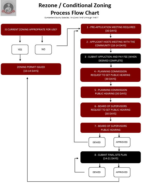
By following a uniform layout for each process, the development process will become easier to follow all code users. Each development application or process should have subsections that address the questions found in Table 4.4.1-1: Procedural Questions below. Answering these questions and incorporating graphics such as Figure 4.4.1-1: Example Development Approval Flow Chart – Cumberland County, VA to depict content-saturated processes are necessary features that improve code, transparency, readability, and usability.
Table 4.4.1-1: Procedural Questions
Component
Question To Be Addressed Applicability Who needs to go through this process?
Initiation
Completeness
Notice and Hearing
Action
Standards
Subsequent Applications
Appeals
Scope of Approval
Recordation
How and to whom is an application submitted?
What is required when an application is ready to process?
What noticing requirements apply to a development application? Are there any public hearings required? If so, how many?
Who reviews, recommends, and makes decisions? How are decisions made?
What specific standards or criteria apply to the application?
If an applicant withdraws or is denied, can they file a new application? When can a new application be filed?
Who and how can an applicant appeal a decision?
What does this approval allow the applicant to do? What is the next step in the process?
Who records the final document and where can it be found?
4.4.2 The purpose, roles, and responsibilities of the approval bodies are unclear.
4.4.2.1 Clearly establish the approval bodies such as the City Council, Planning Commission, Zoning Boad of Appeals, River District Design Commission, and the Commission of Architectural Review and outline each of their unique roles in the development process.
While the current Zoning and Subdivision Ordinances address who acts on each development application, the code can be improved by providing an authority summary table as seen in Figure 4.4.2-1: Procedural Approval Summary – Dublin, OH. This table can provide clarity to the user regarding who reviews and acts on a specific application without sifting through each development application procedure. The common understanding is that the City staff, Planning Commission, and City Council play critical roles in the development process by making recommendations and approving the numerous development applications. Since these bodies are frequently involved with the development process, it is imperative that the code user knows how these bodies interact with the development process without wasting time combing through the UDC’s text.
4.4.3 The Zoning and Subdivision Ordinances generates an overreliance on decisions made by approval bodies like the City Manager, Planning Commission, and City Council.
4.4.3.1 Expand staff-level approval opportunities for development applications.
The development process often takes a long time to navigate. The development process can be shortened if the UDC empowers staff to make decisions. While leaving decision making to approval bodies like the Planning Commission has been a historically acceptable practice, it can come with a litany of problems. The biggest potential problem is that developers can become subject to the preferences of the approval body rather than the regulations contained in the code. To prevent this, the UDC should clarify regulations and set well-defined parameters that empower staff to make decisions on nonlegislative applications. Ultimately, the Planning Commission and the City Council should only make decisions on quasi-legislative and legislative applications. Reducing the approval bodies’ obligations and allowing staff to make decisions can expedite the development process, improve staff confidence, ensure a fair development process, and reduce taxpayer spending. The new UDC can improve the development process by allowing staff to decide nonlegislative development applications.
4.4.4 The Zoning and Subdivision Ordinances have limited forms of regulatory relief.
4.4.4.1 Provide regulatory relief tools approved by staff such as alternative compliance and minor modifications to alleviate code rigidity and expedite the development process. Like many codes, the current Zoning and Subdivision Ordinances fail to do much in terms of development flexibility. While the Zoning Ordinance allows minor modification relief for PUDs via the Zoning Administrator, the main option for regulatory relief is through variances. As Danville looks to expand housing options, development flexibility should be maximized by establishing additional relief options. For instance, many modern codes provide regulatory relief tools such as alternative compliance, special exceptions, minor modifications, and design exceptions to accommodate development scenarios that meet the intent of the regulation but fail to strictly adhere to all the regulation’s requirements. Furthermore, these options provide relief for developments that may not meet the hardship requirement for a variance. The new UDC should encourage development relief that produces similar development outcomes consistent with the spirit and intent of the regulations.
4.5.1 Definitions are located throughout the Zoning and Subdivision Ordinances making them difficult to find.
4.5.1.1 Create an article at the end of the UDC exclusively for definitions, acronyms, and commonly used phrases.
In the current Zoning Ordinance, definitions are largely found in Article 15 at the end of the code; however, definitions are missing in the Subdivision Ordinance. Although it is atypical to have two ordinances with only one definitions article, this practice should continue with the establishment of the UDC. However, in the Zoning Ordinance, there remain instances where definitions are found outside of the definition article, adding confusion about where definitions can be found. While it can seem appealing to have definitions in locations where a term is applicable, it is best practice to locate all definitions in the same article.
4.5.2 The Zoning and Subdivision Ordinances have occasional inconsistencies with State Law.
4.5.2.1 Align UDC terms and definitions with any recent State Law changes. Often when codes have not been updated for a while, there are instances where definitions are inconsistent with amendments to State Law. Danville’s Zoning and Subdivision Ordinances have occasional instances where terms and definitions are not adequately aligned with State Law. As such, the UDC should address these inconsistencies by aligning definitions and terminology with that of the Code of Virginia, Virginia Administrative Code, Constitution of Virginia, and any other State regulations applicable to planning and development.
Zoning districts establish what land uses are permitted on a given piece of land and govern the characteristics, design, construction, and spatial relationship of such uses. Creating zoning districts allows cities to promote the development of cohesive and harmonious neighborhoods, commercial center, mixed-use corridors, and employment areas. Originally used to separate noxious industrial uses from residential areas, contemporary zoning districts are used as a tool to build walkable, attractive, and sustainable communities. Zoning district standards typically contain the following elements.
1. Use Permissions. In each district, some uses are permitted, some are prohibited, and others are regulated through discretionary review such as special use permit approval. Many uses have conditions or standards that apply whether the use is permitted or requires special use permit approval.
2. Dimensional Standards. Dimensional standards are crucial for maintaining orderly development and ensuring compatibility between different land uses. These regulations maintain orderly development by establishing requirements such as lot sizes, building heights, and setbacks, and density. Together, they provide the framework for balanced development that aligns with a city’s planning goals.
3. Design Standards. These standards are used to describe how a site or building should be located, designed, and developed. Regulations that are typically included in design standards include minimum parking, landscaping, fencing, and fenestration requirements. Carefully considered design standards can encourage development that complement the surrounding area and contribute to the city’s preferred development outcomes.
In Danville, the current Zoning Ordinance establishes 17 base zoning districts, including 7 overlay districts as found in Table 4.5.2-1: Existing Districts below.
Table 4.5.2-1: Existing Districts District
Sandy River Residential SR-R Purple
Threshold Residential T-R Light Yellow
Suburban Residential S-R Dark Green
Neo-Traditional Residential NT-R Lime Green
Residential
Old Town Residential OT-R Maroon
Attached Residential A-R Orange
Multi-Family Residential M-R Light Orange
Manufactured Home Park MHP-R Grey
Transitional Office
Nonresidential
Light Blue
Neighborhood Commercial N-C Indigo
3 This section will identify the current code’s barriers to the preferred development outcomes as envisioned in the Comp Plan. Also, this section will propose bridges (i.e., solutions or recommendations) that can be figuratively constructed to create the preferred development outcomes.
Overlay
Central (Downtown) Business
Commercial CB-C Navy
Tobacco Warehouse Commercial TW-C Light Green
Highway Retail Commercial HR-C Light Purple
Planned Shopping Center
Commercial PS-C Pink
Light Economic Development LED-I Red
Cyber Park One CP-1 Light Red
Manufacturing M-I Pink
Historic Preservation Overlay HP-O Red Outline
Airport Overlay A-O Blue Outline
Floodplain Overlay FP-O Varying
Planned Shopping Center PSC-O
Casino Entertainment C-E
River District Overlay RD-O Green Outline
West Main Street Corridor Overlay WMCO
5.1.1 Zoning district purpose statements are long and include unnecessary regulations.
5.1.1.1 Condense the purpose statements to be less regulatory in nature.
Purpose statements offer valuable opportunities to state the city’s intent in establishing a zoning district or regulatory requirement. For example, staff and the Planning Commission can use a purpose statement to determine if a proposed development fits the character of a neighborhood. While purpose statements can have regulatory force, they should not strive to be regulatory. The purpose statements found in the current Zoning Ordinance are lengthy and often include requirements such as minimum floor area, minimum parking requirements, and maximum density. These requirements should be removed from the purpose statement to other sections within the zoning district. The new purpose statements should be no more than one paragraph, sometimes in a bullet format, and lay out the visions and objectives of the zoning district as it relates to the city’s long-range planning policies. Loudoun County, VA offers a good example of a purpose statement for a residential district in Figure 5.1.1-1: Example Purpose Statement - Roanoke, VA below. While some communities provide zoning district purpose statements in a bullet format, others do so in a conventional manner similar to Arlington County, VA (see Figure 5.1.1-2: Example Purpose Statement – Arlington County, VA). Either way, the UDC should use a modern district purpose statement approach in a streamlined format.
Figure 5.1.1-1: Example Purpose Statement – Loudoun County, VA
Figure 5.1.1-2: Example Purpose Statement – Arlington County, VA

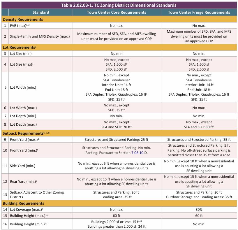
5.1.2 It is inconvenient to find district dimensional standards.
5.1.2.1 Create dimensional standards tables for each district.
Dimensional standards such as minimum lot areas, minimum lot width, setbacks, and maximum building height requirements are useful tools in establishing preferred district-specific development outcomes. However, the current Zoning Ordinance makes these standards difficult to find. For example, the Threshold Residential (T-R) District includes separate sections for maximum density, lot size, developable area, and bulk requirements with individual requirements typed one after another. While this is a good starting place, dimensional standards could be made easier to find and more digestible by creating a dimensional standard matrix for each zoning district or for all
zoning district within a category. Figure 5.1.2-1: Example Dimensional Standard Matrix – Loudoun County, VA is an example of a dimensional standard matrix from Loudoun County, VA.
5.1.3 Unnecessary required district area minimums limit development opportunities.
5.1.3.1 Remove district area minimum requirements and simply rely on lot dimensional requirements.
Minimum district area requirements are effective tools for preventing single districts with only one lot. In theory, this practice encourages advantageous neighborhood design by ensuring that the same rules apply to neighboring lots. Under the current Zoning Ordinance, the Sandy River Residential (SR-R) District requires a minimum district size of five acres. Thus, the current Zoning Ordinance would allow five one acre lots to be rezoned but not three one acre lots. The UDC should refrain from continuing its existing preference for district minimums to ensure single lots are able to be rezoned as long as it complies to the district’s intent. The current practice creates barriers to
redevelopment because lot splits and the desire to create smaller lots for dwellings as indicated by market trends, is not possible unless requesting a rezoning or asking for a form of regulatory relief. Additionally, the current practice is outdated and not appropriate given that these types of standards are best suited for communities with abundant greenfield development opportunities. This is the case because a community can easily apply required district area minimums to larger tracts of undeveloped tracts with a unified vision; however, in Danville, greenfield opportunities are not as available as they once were. As such, the current practice directly limits infill and redevelopment opportunities for Danville residents, particularly for residential development, ultimately creating conflict with the Comprehensive Plan’s housing goals. Such a practice, which is inherently arbitrary and intentional, undercuts Danville’s desire to add housing, encourage housing affordability, and increase diversity in housing. The UDC should not be in the business of continuing arbitrary practices that blatantly ignore the Comprehensive Plan’s goals and make redevelopment an even bigger challenge than it already is in Danville. Instead, the UDC should eliminate the minimum district area requirement practice to facilitate more housing and reduce barriers to redevelopment.
5.1.4 Predetermined density requirements create barriers to higher-intensity development.
5.1.4.1 Remove density requirements and let the lot dimensional requirements self-regulate density. Although regulating density is a common practice, it is one that is becoming increasingly outdated. Density has always been a topic of concern for many suburban and rural communities, but data shows the lower the development density, the more strain a community places on its infrastructure system and greater tax burden placed on its residents. To offset this situation, communities with modern zoning codes are starting to increase density, provide density thresholds for certain development types/uses, or eliminate the density requirement all together. While some communities are increasing density through regulation, others are relying on the market to do so. High land prices, homebuyer purchasing power constraints, steep interest rates, building material costs, and inflation limit the income potential for conventional, large lot single-family homes, making developers reluctant to build. Instead of requiring certain densities that are hard to manage especially when redevelopment occurs, the UDC should allow for low-density, single-family development but enable the market to self-regulate Danville’s appropriate density.
5.1.5 Consistent unnecessary dimensional and bulk requirements restrict otherwise permissible and desirable land uses.
5.1.5.1 Remove or consolidate unnecessary and redundant dimensional and bulk requirements. Dimensional standards and bulk requirements are valuable tools in establishing strong community character and promoting preferred development outcomes. Regulations like lot size, setbacks, and building height limit the size and scale of development, ensuring adjacent buildings are compatible. However, each additional standard requires defined measurements and consistent enforcement. Not only is this onerous for the city, but it can also make code compliance more
challenging, encouraging developers to seek relief. To increase clarity and reduce the negative effects of overregulation, the UDC should eliminate unnecessary and redundant dimensional standards and bulk requirements.
5.1.6 An abundance of outdated, single-use zoning districts interferes with desired development patterns.
5.1.6.1 Revise and reduce the number of districts through the consolidation of similar districts. The current Zoning Ordinance provides eight residential districts throughout Danville. While some of these districts are commonly found throughout the city, others are seldom used. Many of the less-used residential districts are single-use districts that allow only one housing type. Such districts present barriers to the walkable, diverse neighborhoods called for in the Comprehensive Plan. Furthermore, the same issue persists in Danville’s eight nonresidential districts, preventing mixed-use development and corridor-focused growth. For that purpose, the UDC should reduce the number of single- or limited-use districts through consolidation. For example, S-R and OT-R are some residential zoning districts in Danville that offer nearly identical use permissions that are prime for district consolidation. Furthermore, less-used zoning districts such as the NT-R and T-R districts should be reassessed and considered for district consolidation. If this approach is utilized, the UDC could have three or four residential districts instead of eight. While that may seem like an oversimplification to zoning consolidation that fails to consider various single-family housing contexts, it does not mean that these districts cannot have additional regulations to provide residential variety. This can be addressed by establishing criteria for housing variety. If the City prefers to keep multiple single-unit residential districts, it will be critical to allow more missing middle housing types such as duplexes, triplexes, and cottage courts in the higher density residential districts.
For the nonresidential districts, consolidation should be targeted to align with best practices. Modern codes are deviating from the conventional district classification system of office, commercial, and industrial and moving towards a more holistic, flexible classification system. For example, codes have started combining office and commercial districts together, and in some instances, have consolidated industrial districts with office and heavy commercial districts. In Danville, the separation of office, commercial, and manufacturing districts is unnecessary and should gravitate towards the modern zoning model. As such, the UDC should consider consolidating the HR-C and PSC, the TO-C and N-C, and the LED and CP-1 districts into single districts. This consolidation is even more attainable because of office space trends. Since the pandemic, office space demand has drastically decreased resulting in less office development. Unsure of the demand for new office space given market conditions, it is reasonable to consolidate the office and commercial districts.
5.2 Uses
5.2.1 Prescriptive use allowances make it difficult to determine where a specific use is permitted.
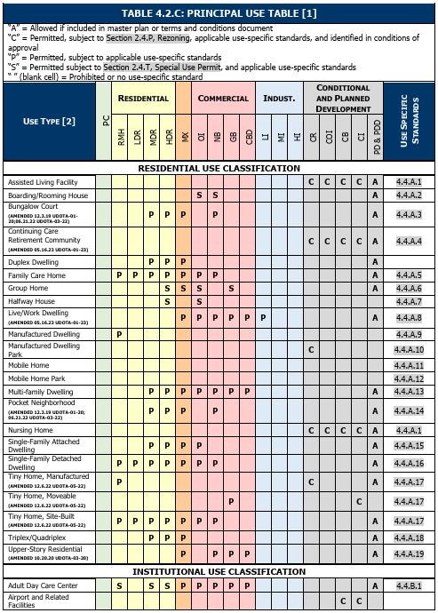
5.2.1.1 Eliminate prescriptive use allowances by zoning district and establish a Use Table. The current Zoning Ordinance provides use allowances for each zoning district at the beginning of the district’s section. While the use allowances are clearly identified, the current approach is outdated. Previously, zoning ordinances listed all the permitted uses in each district, which would lead to missing use allowances in other districts. Best practices have evolved by establishing a Use Table that lists all uses and assigns allowances by zoning district in one location. This type of best practice is becoming increasingly prevalent as seen in Figure 5.2.1-1: Example Use TableBurlington, NC. Danville should follow a similar approach to Burlington and allocate uses in a comprehensive, succinct, and understandable manner starting with a use table.
5.2.2 Use regulations are scattered throughout the Zoning Ordinance.
5.2.2.1 Create a section called “use specific standards” where all use regulations are located.
The current Zoning Ordinance is careful to limit the negative effects of many permitted uses through regulations that apply to specific uses, regardless of their district. For example, a retail store could be allowed in all commercial zoning districts with the use-specific standards regulating the size, location, and form of that use for each district. This is an impactful strategy that allows cities to implement finely tailored solutions to problems associated with uses ranging from apartment complexes to industrial manufacturing. However, the current Zoning Ordinance displays these uses in seemingly random places including district purpose statements, use permissions, and term definitions. Without a centralized set of “use specific standards,” it is difficult for a code user to verify that their use complies with these standards. By consolidating these standards into a single section, code users can quickly find if their use is regulated by any additional standards. To increase ease of use, the comprehensive use table described in Section 5.2.1.1 of this report could include the section number of each use’s standards as shown in Figure 5.2.1-1: Example Use Table - Burlington, NC.
5.2.3 Unrefined uses and inconsistent use references.
5.2.3.1 Define all uses and eliminate duplicated terms.
Since the current Zoning Ordinance lacks an organized list of all uses allowed in the city, there are many instances of duplicated or redundant uses. A preliminary audit of the uses allowed through the current Zoning Ordinance’s prescriptive use allowance system revealed close to 500 different use terms throughout the document. Many of these use terms are nearly identical to one another or draw an unnecessary distinction between two uses. For example, “call centers” do not need to be distinguished from “professional offices, including accountant, architect, engineer, landscape architect, lawyer, etc”. Instead, these uses could be combined into a single “office” use.
Consolidating similar uses will enable code users to easily navigate the use table described above. Furthermore, combining use terms will ensure that all uses are fully defined. In the current Zoning Ordinance, many use terms remain undefined because they include examples, regulatory language, and exceptions. The UDC will define each use while the regulatory language for each use is located in a “use standards” section.
5.2.4 The current housing typology restricts housing options and availability.
5.2.4.1 Expand the housing typology.
One of the most vital sets of land uses recommended for Danville by the Comprehensive Plan are those related to housing. Recently, housing has become increasingly relevant in national planning efforts. Housing, particularly in communities like Danville, tends to be limited in diversity, offering mostly single-unit, detached dwellings. The UDC should aim to expand those options to accommodate the different needs of residents. The UDC should act on this approach by establishing a robust housing typology of various sizes, styles, and densities to address missing
housing gaps. Housing uses like triplexes, multiplexes, cottage courts, courtyard apartments, and build-to-rent communities should be provided throughout the city and allowed in zoning districts where a diverse housing palette is encouraged or preferred. While many communities struggle with housing, jurisdictions in the mid-Atlantic region are moving in a positive direction. For instance, Raleigh, NC recently overhauled their UDO, including a completely revamped housing framework that provides tiny houses, cottage courts, and accessory dwelling units. Although Danville and Raleigh are not of the same stature and feel, Danville should build on a similar housing typology to that of Raleigh’s to increase residential options, accelerate housing development, and provide more attainable housing than the current housing stock.
5.2.5 Too many uses require lengthy special use permit approval.
5.2.5.1 Reduce the number of uses that require special use permits by implementing use-specific standards.
While it is typical to allow uses by-right and by special use permit, it is generally a best practice to reduce the need for special use permit approval as much as possible. Special use permit processes cause greater uncertainty since the Planning Commission and City Council use their discretion to decide whether the use should be allowed in a district. As an alternative to the overuse of special use permits, the UDC should find ways to reduce administrative hearings by implementing the aforementioned use-specific standards where necessary. As previously mentioned, these standards are helpful for regulating development scale and use compatibility without Planning Commission and City Council intervention.
5.3.1 Minimum required parking spaces and high parking ratios provided in the Zoning Ordinance create barriers to development.
5.3.1.1 Reduce parking minimums by implementing parking maximums or requiring parking studies. While developments need parking to accommodate customers, employees, and community members, overparking should be avoided. Overparking can disrupt land use patterns, increase the urban heat island effect, negatively impact stormwater drainage basins, add extra costs to development, and promote greater reliance on the automobile. In modern codes, conventional parking requirements like parking minimums can be reduced, replaced, or supplemented with parking maximums and Traffic Demand Management plans, such as in Charlottesville, Virginia which eliminated parking minimums in favor of required Traffic Demand Management plans for developments with more than 50,000 square feet of gross floor area. While the Charlottesville approach would be a drastic change in direction for Danville, it offers an idea for how the new Zoning Ordinance could reduce the minimum parking spaces required in Article 8. No matter what method of reduction is desirable, the minimum required parking spaces should generally be reduced by 50% to align with best practices.
5.3.2 Parking regulations lack context sensitivity to different development patterns.
5.3.2.1 Right-size parking regulations by identifying different parking ratios and matching them within certain development contexts.
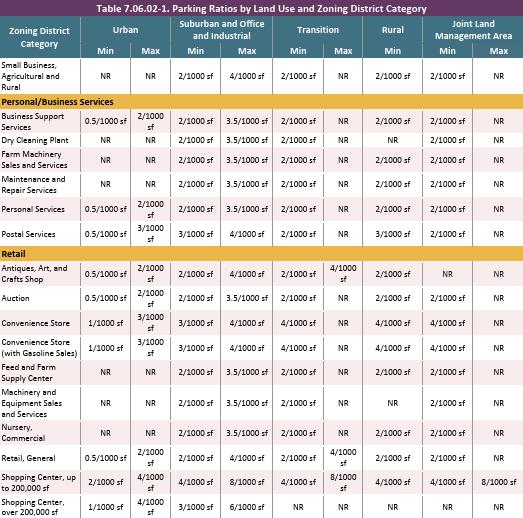
Most modern codes do not use a one-size-fits-all parking approach because it promotes overparking and automobile reliance. The current Zoning Ordinance employs one parking standard for each use, regardless of the context of its zoning district or neighborhood. Most modern codes do not approach parking with a one-size-fits-all strategy because it promotes overparking and automobile reliance where other modes of transportation could be employed. The UDC should offer flexible parking requirements in higher density, mixed use areas for certain uses to achieve a more pedestrian-friendly environment. Loudoun County, VA employs a similar approach as seen in Figure 5.3.2-1: Example Context-Sensitive Parking Ratios - Loudoun County, VA where minimum and maximum parking ratios are scaled according to zoning district category. This means the City will implement a tailored parking approach that ties together development context, neighborhood character, and the goals of the City’s long-range planning policies to deliver on pedestrian-friendly, mixed-use development. For instance, in a conventional commercial district it may still be suitable to accommodate more parking since the automobile is the primary mode of transportation, whereas in a mixed-use district, it is ideal to provide less parking and use other parking management techniques to achieve a vibrant, walkable mixed use area.
5.3.2.2 Provide a variety of alternatives to off-street parking that can be used to meet minimum parking space requirements.
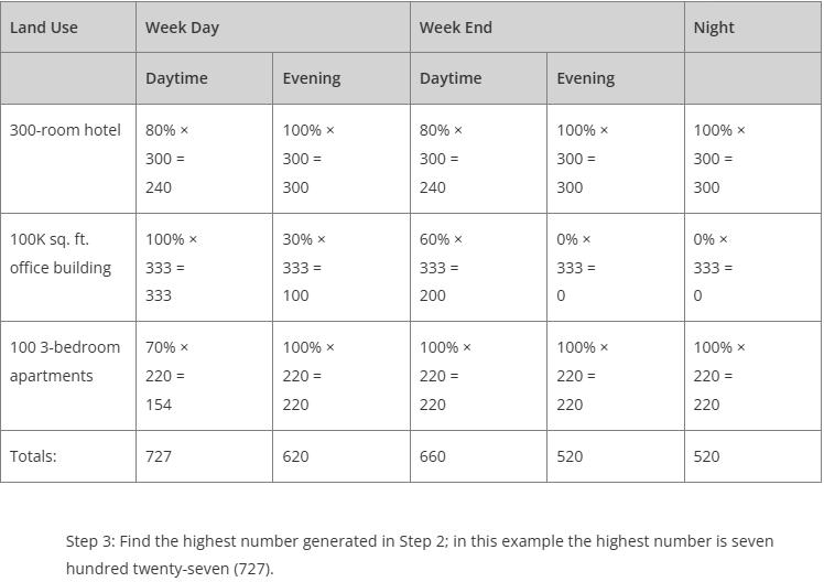
Excessive parking has been a constant development theme over the past decade, and while reducing parking minimums may be a start, sometimes it is not enough to curb overparking. Communities can provide relief to ill-fitting parking requirements through adjustments and reductions. Shared parking ratios, public and on-street parking credits, and structured parking facilities are all useful methods that alleviate the burden placed on developers and businesses by minimum parking ratios. In 2015, Hampton, Virginia adopted a shared parking credit system that reduces the overall number of required parking spaces by allowing uses with different peak parking demand times to share parking spaces as found in Figure 5.3.2-2: Example Shared Parking Credit System - Hampton, VA. Danville should consider these types of parking adjustments and encourage other ways to control overparking in addition to lowering minimum parking ratios.
5.3.3 The Zoning Ordinance lacks alternative transportation considerations.
5.3.3.1 Implement bicycle parking requirements applicable to certain development contexts like downtown and mixed-use areas.
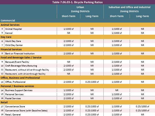
Although parking regulations tend to focus on vehicle accommodations, parking standards should be expanded to include other modes of transportation such as cycling. Bicycle parking should be prioritized particularly in areas like downtowns and mixed-use nodes where pedestrian-oriented development is preferred. While bicycle parking should be accommodated, it should be done so in practical, context-sensitive manners as seen in Loudoun County, VA; Edmond, OK; and Valparaiso, IN. In these communities, bicycle parking standards are provided and assigned contextually throughout the jurisdiction. For instance, Loudoun County employs five development contexts: urban, suburban, transition, rural, and joint land management areas with bicycle parking only required for development in urban and suburban contexts as seen in Figure 5.3.3-1: Example
Context-Sensitive Bicycle Parking Ratios - Loudoun County, VA Danville should follow a similar approach to expanding parking regulations to include bicycle facilities to encourage multimodal transportation and pedestrian-oriented development in some of the City’s premier locations like the River District and near Averett University.
4 In the example displayed above, the uses would individually require 853 spaces; however, the minimum can be reduced to 727 since these uses do not share the same time for peak parking demands. This reduces the overall number of parking spaces by 126 spaces, or almost 15 percent.
Additionally, while bicycle ratios should be provided, the UDC should also implement robust standards and specifications to ensure that bicycle parking is not only provided but accommodated in an aesthetically appealing manner through design requirements. Fairfax County, Virginia offers a variety of structural, locational, and access standards that regulate bicycle parking and its associated facilities in their 2024 Fairfax County Bicycle Parking Guidelines. These requirements also encourage amenities such as bike pumps and storage lockers.
5.3.4 The Zoning Ordinance treats parking as a mode to store cars instead of being comprehensively focused on mobility and parking management.
5.3.4.1 Establish a parking fee in-lieu program for new development in high-activity nodes such as Downtown, Casino, and River District.
In high-growth corridors where development is expected to increase, off-street parking can be an inefficient use of land. To encourage this pattern of dense development, cities can establish fees that are in-lieu of minimum off-street parking requirements. Instead of offering parking spaces, new development pays a fee into a designated city-controlled fund used to build new parking facilities and improve parking infrastructure. These programs can be either voluntary or required, depending on the community’s collective preferences. Although parking fee in-lieu programs are seldom seen throughout America, they are common in jurisdictions where parking is at a premium, land prices are high, and tourism is a chief economic driver. Tourist towns like Breckenridge have
effectively and successfully used parking fee in-lieu programs to increase public parking, relieve developers of paying, building, and maintaining on-site parking facilities, and curb overparking in walkable areas. In Breckenridge, CO, a developer can pay into the Town’s parking fund at a rate of $19,236 per required parking space. If the Town fails to use the site’s collected funds within 10 years, the Town refunds the collected funds back to the developer with interest. Although Breckenridge charges a high rate per parking space, the code can provide a parking fee in-lieu program that modifies the parking space rate to a price point that fits Danville. While these parking fee in-lieu programs are most common in ski/resort towns, such programs have made its way to the mid-Atlantic states. In Montgomery County, MD, in-lieu fees chosen by developers instead of building required on-site parking are used to finance the construction and management of parking spaces in centrally located public garages that serve multiple developments. Such an approach to required parking not only benefits the developer, but the community at-large by encouraging shared parking, infill and adaptive reuse, and improved safety. The UDC should consider implementing a parking fee in-lieu program where higher-intensity growth is most probable.
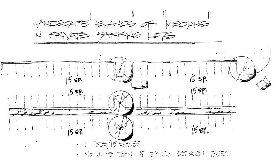
5.4.1 The current landscaping requirements lack context-sensitivity and provide few methods of relief when compliance burdens a development.
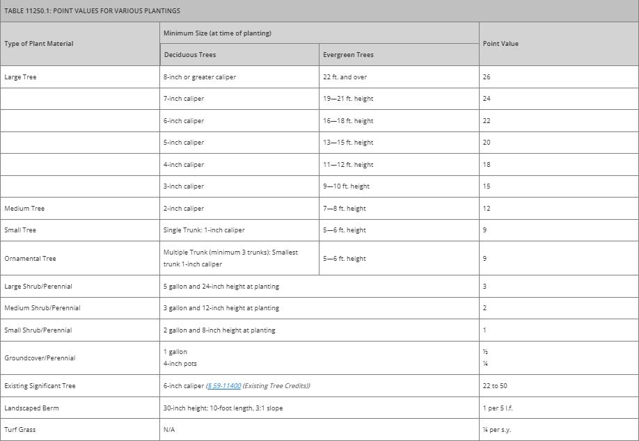
5.4.1.1 Require landscaping for nonresidential development but do so in a context-sensitive manner. The current landscaping article is robust, but its inflexibility hinders development and lacks context sensitivity. Although this may be reflective of a one-size-fits-all regulatory approach, there are other options for alternative methods of compliance. One way to allow for alternative methods of compliance is through a points-based regulatory framework. Instead of requiring 10 percent of a site to be covered by tree canopy or all coniferous trees must be at least six feet in height, the UDC could establish a points-based system where the developer chooses from a menu of landscaping elements to provide sufficient on-site landscaping. For instance, the UDC could require varying landscaping points for different buffer strip widths, the number of trees on-site, the size and spacing of those trees, use of shrubs, implementation of native plant materials and xeriscaping techniques. For example, Oklahoma City utilizes a points-based landscaping system where points are calculated by the number of site points, parking lot points, and frontage tree requirements applicable to zoning district in which those points determine the percentages and location of plantings, quantity, type, and size of plant materials needed on site as displayed in Figure 5.4.1-1: Example Point-Based Landscaping System - Oklahoma City, OK While Oklahoma City is a significantly larger city than Danville, this type of flexible landscaping approach is something that could be implemented in Danville.
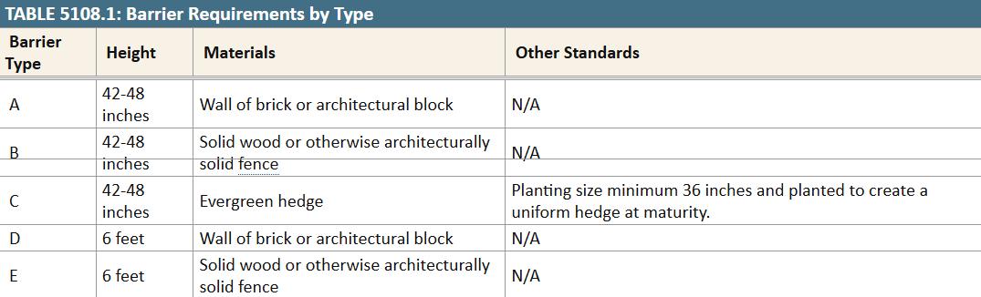
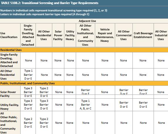
5.4.2 Screening standards are difficult to navigate.
5.4.2.1 Provide a screening matrix that indicates the screening type, design specifications, and how a screen type applies in different development contexts.
Although the screening standards are relatively straightforward, the requirements could be better communicated to the reader. Instead of requiring the reader to scour through sentences of regulations, the UDC should reduce these sentences by providing the relevant content into a master screening matrix that indicates where screening is required, which screening types are permissible, and what specifications are required Fairfax County, Virginia employs this approach as seen in Figure 5.4.2-1: Example Screening Matrix - Fairfax County, VA below.
5.4.3 Screening standards are inadequate during parts of the year.
5.4.3.1 Require year-round plant materials for any proposed vegetative screen.
The current Zoning Ordinance allows either deciduous or evergreen trees for screening purposes so long as they are approved by the Director of Planning or the Planning Commission. By allowing deciduous plantings, year-round screening may not be provided since deciduous trees lose foliage
5 Table 5108.1 of the Fairfax County Zoning Ordinance sets out the types of permitted screening while Table 5108.2 establishes where such types of screening are permitted.
each winter. For any required vegetative screening, year-round plant materials should be used to ensure a continuous screening effect. Vegetative screens that do not use evergreen plant materials are susceptible to missing gaps within the screen, so it is essentially vegetative screening provides coverage year-round.
5.5.1 No architectural standards are provided to promote aesthetically pleasant development.
5.5.1.1 Provide architectural/form standards by incorporating the City’s existing architectural guidelines into the UDC.
While design guidelines regulate some of Danville’s neighborhoods including the River District and the Old West End, many parts of the city solely rely on use and dimensional standards to achieve desirable development outcomes. To better enable the desired place types established in the Comprehensive Plan, Danville should build on the existing design guidelines and create architectural or form standards that encourage aesthetically attractive development that achieves the community’s desired development outcomes These standards can establish building typologies, architectural styles, and acceptable building materials to facilitate consistent and comprehensive site design. The UDC can achieve this by implementing design standards throughout the city for all development or with district-specific standards. For instance, the City could have basic, straightforward standards that are universally district agnostic controlling for things like building materials and architectural elements or enhance those standards for each district to where each district has a unique and cohesive design aesthetic. Danville’s existing design guidelines should provide the basis for any new design-related regulations.
5.5.2 Site design standards lack strong pedestrian access requirements.
5.5.2.1 Improve site design and encourage more forms of transportation by providing pedestrian access requirements.
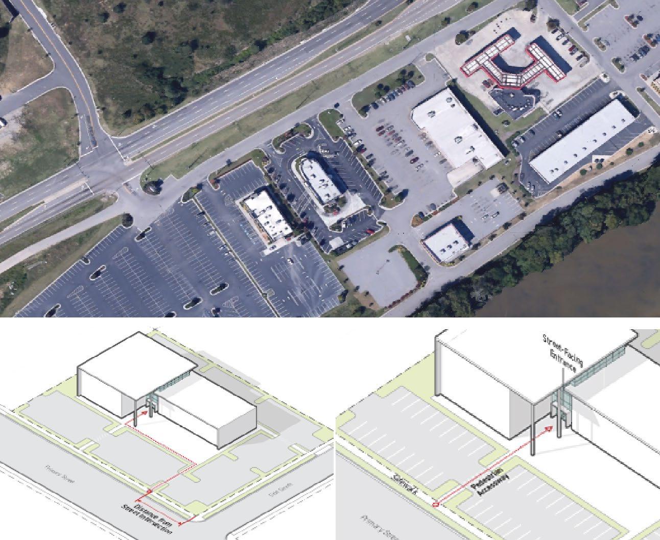
In many car-oriented communities, sites are not required to have access paths beyond what is required by the Americans with Disabilities Act. In many cases, this lack of requirements further prioritizes car-oriented development by separating businesses from any pedestrian rights-of-way, meaning pedestrians and public transit users must traverse unfriendly and dangerous vehicle access drive to access their desired location. The current regulations lack effective stipulations to encourage connections between rights-of-way and building entrances. As a result, some developments in Danville are accessible effectively only by car. The UDC should promote a more diverse array of transit options by requiring new developments to include some level of adequate pedestrian access. Charlottesville, Virginia offers strong, context-sensitive guidelines for connecting entrances to pedestrian paths. Figure 5.5.2-1: Comparison of Pedestrian Access -
Charlottesville, VA shows a development outcome in Danville compared to the access requirements set forth in Charlottesville.

5.6.1 Restrictive sign allowances limit expression.
5.6.1.1 Consolidate sign types and provide more permissive regulations.
The current Zoning Ordinance’s sign regulations classify more than 20 different types of signs. While providing a comprehensive set of sign standards is necessary, it is important not to distinguish between two types of signs just because they can be differentiated. Like all zoning regulations, sign regulations should only regulate what is necessary Sign types should be consolidated practically according to function and form, and regulations should be loosened to reduce restrictions and allow for greater freedom of expression.
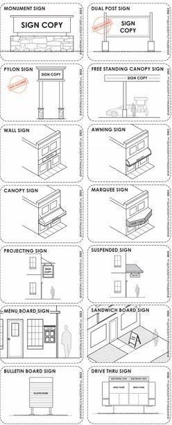
5.6.1.2 Provide visual aids through graphics or examples of desirable signs.
At the store, on their way to work, and in their neighborhoods, people see signs every day. However, few people stop to distinctly classify signs. While the practice is necessary for the application of a sign code, sign classifications can confuse code users, especially when those codes heavily rely on text descriptions. The current Zoning Ordinance relies entirely on text to describe each sign type. While the current language is straightforward, graphics, diagrams, and pictures can improve code
users’ abilities to identify which sign types apply Middleton, WI offers an example of how sign diagrams can provide useful aids to a sign code as seen in Figure 5.6.1-1: Example Sign DiagramsMiddleton, WI.
5.6.2 Noncompliant sign regulations with Constitutional principles and case law.
5.6.2.1 Continue regulating signs in a manner that protects constitutional principles.
Overall, the Zoning Ordinance does an average job of protecting constitutional principles guaranteed by the 1st and 14th Amendments. There are lapses where constitutional principles need to be revised. For instance, signs like “Real Estate Signs” and “Business Identification Signs”
should be modified to align with 1st Amendment liberties because the sign type regulates the content of the sign. The UDC should clean up all content-based restrictions and strengthen constitutional principles by ensuring sign standards only regulate the time, manner, and place of signs.
5.6.2.2 Organize signs standards into comprehensive tables to increase ability to identify what standards are required for each sign type in each district. The current Zoning Ordinance includes tables that summarize sign allowances in Residential, N-C, TO-C, CB-C, TW-C, HR-C, PS-C, CP-1, LED-I, and M-I districts. The tables provide useful information such as the number of signs allows per use, the dimensional requirements for said sign, and the illumination standard for signs in the district. These tables can be expanded and improved to show which sign types are allowed by district in a more understandable format An example of simplified sign tables can be seen in Raleigh, NC where sign allowances by district are summarized at the beginning of the sign regulations.

5.7.1 The Zoning Ordinance does not adequately account for infill development.
5.7.1.1 Create infill development standards or an infill zoning district to allow greater flexibility for infill developments.
In addition to being an eyesore to neighbors, undeveloped and underdeveloped lots within an existing development fabric contribute to urban sprawl, higher costs of living, and reduced climateresiliency. Zoning ordinances should encourage the development or redevelopment of these lots through infill development. The current Zoning Ordinance provides little flexibility for infill development, often requiring them to meet all applicable district standards. The new Zoning
Ordinance should accommodate infill development in those instances where development would not conform to the underlying district standards. Infill standards can be achieved by modified dimensional standards, dimensional standard averaging, or a floating zoning district.
Fredericksburg, Virginia offers infill-specific calculations that average the setbacks of similarly sized lots within the same or opposing block faces. This regulation allows for the meaningful redevelopment of lots that are otherwise untenable.
5.8.1 The Subdivision Ordinance does not encourage the variety of transportation options deemed desirable by the Comprehensive Plan.
5.8.1.1 Increase the minimum sidewalk width to reflect best practices.
The Subdivision Ordinance does not currently require a minimum sidewalk width for new subdivisions Furthermore, the Comprehensive Plan calls for wider sidewalks with better connectivity. To meet these desired mobility improvements, the UDC should require new subdivisions to include sidewalks that implement best practices or meet current standards from the Virginia Department of Transportation or the Federal Highway Administration This furthers the goals of the Comprehensive Plan by encouraging connectivity and better community amenities for residents to enjoy.
5.8.1.2 Provide rightsized access management standards that reduce driveway proliferation. Access management standards are critical code components. Without them, development becomes disjointed, safety risks increase, and congestion mounts. These standards typically include driveway locations and alignment, the number of driveways per development, connectivity, and shared cross access between developments. It is best practice to provide at least two points of access for nonresidential development to facilitate emergency vehicle access and distribute through traffic. Furthermore, the UDC should specify instances requiring cross access consistent with best practices and current Virginia Department of Transportation guidance and standards. Cross access for three or more adjoining nonresidential lots located on arterials can alleviate additional driveways, improve site circulation, and encourage safer streets.
Additionally, it is important that the UDC provides adequate driveway spacing standards to reduce congestion and improve traffic safety. Developments that have multiple driveways spaced closely together create conflict points because vehicles must constantly start and stop entering and exiting the development. Driveways should be minimized and sufficiently spaced from one another to eradicate conflict points. The UDC should include this approach and explore ways to improve traffic safety and circulation by referencing informational documents and guidance provided by the Virginia Department of Transportation
5.8.1.3 Require the implementation of traffic calming devices for new street segments to produce safer streets.
Street designs that prioritize the movement of vehicles can create challenges to the overall safety of that street. Streets are an important part of a city’s development fabric. Street design should use a holistic approach that encompasses varied travel lane widths, improved pedestrian facilities, multi-modal thinking, when practical, and traffic calming devices to create safe streets and protect pedestrians. While there are street design standards in the Subdivision Ordinance, these standards are limited. For instance, specific requirements like crosswalks, street jogs, and traffic calming devices are not mentioned Street design standards should reference best practices and Virginia Department of Transportation guidance or standards for potential pedestrian measures and traffic calming measures. This guidance can be used to determine if traffic calming measures are appropriate for the street being considered and if so, what measures may be effective for the desired results.
There are cities across the nation that provide a complete assortment of design criteria that address all the critical street components. Some cities specify acceptable traffic calming devices, list bicycle facilities specifications, and provide detailed street design standards for each street type. However, other cities take similar standards further by providing tables and graphics that show street design criteria and additional streetscaping standards like street furniture and planting requirements. Ultimately, robust street design standards should be calibrated to Danville’s preferences and should reference existing Virginia Department of Transportation guidance or standards to create a safer street network.
5.8.1.4 Establish a pedestrian facilities zone such as bike paths, sidewalks, on-street parking, and street furniture within public rights-of-way
Some of the most critical components of a street right-of-way are its accompanying facilities. If appropriate, consideration should be given to amenities and features that promote multimodal transportation and safety.. Street rights-of-way should not only include space for bike facilities, sidewalks, on-street parking, and street furniture but require dedicated areas within the right-ofway to achieve safer, more complete streets As previously mentioned, the street design standards should be expanded, and establishing pedestrian facilities zones are another way to meet the City’s complete streets goals.
5.8.1.5 Provide connectivity regulations, including a connectivity index, and embed these regulations as a part of subdivision design.
Connectivity and access management go hand in hand. Residential subdivisions should always strive to be a place where residents can navigate the neighborhood conveniently and easily engage in city-wide amenities like parks and trails. Some cities establish a connectivity index to indicate the level of connectedness within a subdivision during the platting process as found in Figure
5.8.1-1: Example Connectivity Index - Brownsville, TX Such an index means new subdivisions must meet a minimum connectivity ratio by taking the number of links and dividing it by the number of nodes. Links are defined as non-arterial roadway segments that connect the nodes, whereas nodes are the intersection and terminus of non-arterial streets. Nodes include any location where a street name changes and any curve that exceeds 75 degrees. This type of approach improves connectivity by assuring a well-designed, minimum level of access to and from destinations in a new subdivision. Danville should consider a similar approach to implementing a connectivity index but should include amenities like trails and open space as components of the connectivity index equation. Intentionally designed and well-implemented connectivity standards are preferable given the City’s planning policies on enhancing community amenities, improving walkability, and encouraging more accessible neighborhoods, when feasible.
5.8.1-1:
5.8.1.6 Provide sensible baseline lot standards with built in flexibility through the subdivision design. The Subdivision Ordinance provides a variety of subdivision design standards regulating the design of streets, lots, and utilities within proposed subdivisions. While it is typically conventional best practice to establish baseline lot design standards, there is some utility allowing deviations from the baseline standards in certain circumstances. For example, in parts of Danville with challenging terrain or areas facing land scarcity, flag lots are appropriate because it eradicates vacant land parcels and allows meaningful development. While flag lots are currently prohibited by the Subdivision Ordinance, development on flag lots should be allowed when it is impossible to create a standard lot. However, flag lot development should not be a preferred development solution and
a practice that is frequently used There should be exceptions for when flag lots are acceptable depending on specific criteria. Such criteria could include requiring a certain amount of street frontage, obtaining an additional access easement, and pledging to provide enhanced fire/life safety features. The UDC should not only provide basic lot standards, but allow flexible relief in situations where atypical lots may pose development difficulties.
5.8.2 The Subdivision Ordinance lacks effective adequate public facilities regulations.
5.8.2.1 Consider changing adequate public facilities (APF) or level of service standards to determine the appropriateness of development and potential impact on existing infrastructure systems.
Growing cities can easily become prone to infrastructure strain. Roads, schools, emergency services, water and sewer capacity are all affected by development and growth pressure. Future growth concerns can be addressed by adequate public facilities (APF) regulations or level of service standards. These regulations are designed to balance the timing of new development with planned public expenditures such as roads, transit facilities, water and sewer service, and emergency services. APF regulations condition the approval of new development on a finding that sufficient public facilities and services are in place or will be provided within a reasonable time frame to serve the new development. These can be accomplished by requiring calculation thresholds to condition development intensity. For instance, Howard County, MD uses APF regulations to determine if a proposed development can be supported by the County’s existing infrastructure. If a development cannot by supported, then the developer must provide the required infrastructure for development approval. The UDC should consider APF regulations and determine a calculation system to ensure new development is feasible and the City grows responsibly.
6.1.1
The current Zoning and Subdivision Ordinances have some effective provisions, but most sections will require significant updates, revisions, or additions to adequately reach the City’s planning goals and objectives. To achieve the goals set forth in the Comprehensive Plan, practices such as outdated zoning classifications, restrictive land-use policies, and a lack of flexibility for mixed-use and infill development should be addressed as they hinder the realization of Danville’s desired development outcomes. By addressing these gaps, the City can create a regulatory environment that supports both current development needs and long-term community goals. Further reorganizing, rewriting, and illustrating existing and revised development requirements will make the UDC easier to read and create higher quality development.
6.1.2
This report is one of the initial steps in the rewrite process as it sets the road map for the new UDC The rewrite process will build on the recommendations within this report and will be further discussed to
determine the best approach to each of the issues presented. Once this report is finalized, the drafting phase of the project will commence.
4.1
4.2
4.1.1
4.1.2
4.1.3
4.1.4
The current Zoning and Subdivision Ordinances are ineffectively organized.
Finding the most important information is challenging.
First-time code users can easily be deterred by the code’s complexity and arrangement.
The Zoning and Subdivision Ordinances lack context sensitivity.
4.1.1.1
4.1.2.1
Modernize both the Zoning and Subdivision Ordinances’ organizational structure to adhere to contemporary best practices by establishing a Unified Development Code (UDC) in a similar format as provided in Appendix C: UDC Annotated Outline.
Locate high-priority content near the beginning of the Zoning Ordinance.
4.1.3.1 Provide instructions on how to use the UDC.
4.1.4.1
Create a hybrid UDC that incorporates a mix of Euclidean, FormBased, and Performance-Based components that appropriately fits the context, character, and goals of Danville.
4.2.1 Too many instances of vague language. 4.2.1.1 Clarify all vague language.
4.2.2 The Zoning and Subdivision Ordinances contain outdated terms and gendered language.
4.2.3
4.3
The Zoning and Subdivision Ordinances contain confusing language.
4.3.1 Graphics are sparingly used and difficult to understand when used.
4.4.1
The Zoning and Subdivision Ordinances’ procedures are not the easiest for code users to understand.
4.4.2
4.4.3
4.4.4
The purpose, roles, and responsibilities of the approval bodies are unclear.
The Zoning and Subdivision Ordinances generates an overreliance on decisions made by approval bodies like the City Manager, Planning Commission, and City Council.
The Zoning and Subdivision Ordinances have limited forms of regulatory relief.
4.2.2.1
4.2.3.1
4.3.1.1
4.4.1.1
Replace outdated terminology and gender-neutral language to reflect contemporary best practices.
Reduce legal jargon and use Plain English to improve the code users experience.
Use reference images, graphics, or diagrams to depict dimensions and design requirements when appropriate.
Map each development process with a newly established common procedural format, beginning with applicability, and continuing to initiation and completeness decision making, appeals, and scope of approval.
4.4.2.1
Clearly establish the approval bodies such as the City Council, Planning Commission, Zoning Boad of Appeals, River District Design Commission, and the Commission of Architectural Review and outline each of their unique roles in the development process.
4.4.3.1
Expand staff-level approval opportunities for development applications.
4.4.4.1
Provide regulatory relief tools approved by staff such as alternative compliance and minor modifications to alleviate code rigidity and expedite the development process.
5.1
4.5.1
4.5.2
5.1.1
5.1.2
5.1.3
5.1.4
5.1.5
5.1.6
5.2.1
5.2.2
5.2
5.2.3
5.2.4
Definitions are located throughout the Zoning and Subdivision Ordinances making them difficult to find.
The Zoning and Subdivision Ordinances have occasional inconsistencies with State Law.
Zoning district purpose statements are long and include unnecessary regulations.
It is inconvenient to find district dimensional standards.
Unnecessary required district area minimums limit development opportunities.
Predetermined density requirements create barriers to higher-intensity development.
Consistent unnecessary dimensional and bulk requirements restrict otherwise permissible and desirable land uses.
An abundance of outdated, single-use zoning districts interferes with desired development patterns.
Prescriptive use allowances make it difficult to determine where a specific use is permitted.
Use regulations are scattered throughout the Zoning Ordinance.
Unrefined uses and inconsistent use references.
The current housing typology restricts housing options and availability.
5.2.5 Too many uses require lengthy special use permit approval.
5.3.1
5.3
5.3.2
Minimum required parking spaces and high parking ratios provided in the Zoning Ordinance create barriers to development.
Parking regulations lack context sensitivity to different development patterns.
4.5.1.1
Create an article at the end of the UDC exclusively for definitions, acronyms, and commonly used phrases.
4.5.2.1 Align UDC terms and definitions with any recent State Law changes.
5.1.1.1 Condense the purpose statements to be less regulatory in nature.
5.1.2.1 Create dimensional standards tables for each district.
5.1.3.1
5.1.4.1
5.1.5.1
5.1.6.1
5.2.1.1
5.2.2.1
Remove district area minimum requirements and simply rely on lot dimensional requirements.
Remove density requirements and let the lot dimensional requirements self-regulate density.
Remove or consolidate unnecessary and redundant dimensional and bulk requirements.
Revise and reduce the number of districts through the consolidation of similar districts.
Eliminate prescriptive use allowances by zoning district and establish a Use Table.
Create a section called “use specific standards” where all use regulations are located.
5.2.3.1 Define all uses and eliminate duplicated terms.
5.2.4.1 Expand the housing typology.
5.2.5.1
5.3.1.1
5.3.2.1
5.3.2.2
Reduce the number of uses that require special use permits by implementing use-specific standards.
Reduce parking minimums by implementing parking maximums or requiring parking studies.
Right-size parking regulations by identifying different parking ratios and matching them within certain development contexts.
Provide a variety of alternatives to off-street parking that can be used to meet minimum parking space requirements.
Diagnostic Report
5.3.3
5.3.4
5.4.1
5.4
5.5
5.4.2
5.4.3
5.5.1
5.5.2
5.6.1
The Zoning Ordinance lacks alternative transportation considerations.
The Zoning Ordinance treats parking as a mode to store cars instead of being comprehensively focused on mobility and parking management.
The current landscaping requirements lack context-sensitivity and provide few methods of relief when compliance burdens a development.
Screening standards are difficult to navigate.
Screening standards are inadequate during parts of the year.
No architectural standards are provided to promote aesthetically pleasant development.
Site design standards lack strong pedestrian access requirements.
Restrictive sign allowances limit expression.
5.3.3.1
5.3.4.1
Implement bicycle parking requirements applicable to certain development contexts like downtown and mixed-use areas.
Establish a parking fee in-lieu program for new development in highactivity nodes such as Downtown, Casino, and River District.
5.4.1.1
5.4.2.1
5.4.3.1
5.5.1.1
5.5.2.1
5.6.1.1
Require landscaping for nonresidential development but do so in a context-sensitive manner.
Provide a screening matrix that indicates the screening type, design specifications, and how a screen type applies in different development contexts.
Require year-round plant materials for any proposed vegetative screen.
Provide architectural/form standards by incorporating the City’s existing architectural guidelines into the UDC.
Improve site design and encourage more forms of transportation by providing pedestrian access requirements.
Consolidate sign types and provide more permissive regulations.
5.6.1.2 Provide visual aids through graphics or examples of desirable signs.
5.6.2.1
5.6
5.6.2
Noncompliant sign regulations with Constitutional principles and case law.
5.7 5.7.1
The Zoning Ordinance does not adequately account for infill development.
Continue regulating signs in a manner that protects constitutional principles.
5.6.2.2
5.7.1.1
Organize signs standards into comprehensive tables to increase ability to identify what standards are required for each sign type in each district.
Create infill development standards or an infill zoning district to allow greater flexibility for infill developments.
5.8.1.1 Increase the minimum sidewalk width to reflect best practices.
5.8.1.2
Provide rightsized access management standards that reduce driveway proliferation.
5.8 5.8.1
The Subdivision Ordinance does not encourage the variety of transportation options deemed desirable by the Comprehensive Plan.
5.8.1.3
5.8.1.4
5.8.1.5
Require the implementation of traffic calming devices for new street segments to produce safer streets.
Establish a pedestrian facilities zone such as bike paths, sidewalks, on-street parking, and street furniture within public rights-of-way
Provide connectivity regulations, including a connectivity index, and embed these regulations as a part of subdivision design.
5.8.2
The Subdivision Ordinance lacks effective adequate public facilities regulations.
5.8.1.6
5.8.2.1
Provide sensible baseline lot standards with built in flexibility through the subdivision design.
Consider changing adequate public facilities (APF) or level of service standards to determine the appropriateness of development and potential impact on existing infrastructure systems.
LU 1
LU 2
Neighborhood Character. Support different neighborhood types across the City, from rural to suburban to urban, integrating a variety of housing options.
Centers with Access to Services. Build up vital services in key areas to make sure all residents can easily access them.
1.2
Preserve Rural Landscapes. Prevent overdevelopment of greenfield and rural areas to preserve their environmental integrity and promote sustainability through cluster development.
Maintain Community Character. Implement place type recommendations of this chapter through zoning amendments to better encourage density and character in these areas.
Encourage Growth in Existing Developed Areas. Maximize the impact of infrastructure investments and minimize the environmental impacts of urban sprawl by promoting growth and development in already developed areas of the city. LU 3
3.1
Connected Corridors. Align land use and transportation enhancements to better connect people with resources.
LU 4
Special Districts. Optimize land availability for economic development.
3.2
Concentrate Corridor Development. Encourage the development of community resources along key transportation corridors to provide residents with expanded access to essential amenities.
Organize Parking and Access. Limit the impacts of parking and access management on the character and flow of corridors.
Rethink Underutilized Land. Use tools such as land swaps, “right sizing” and infill development
Category
Recommendation
T 1
Enhanced Walkability. Promote pedestrian-friendly streets, sidewalks, and interconnected neighborhoods to encourage active living and community engagement.
LU 4.2
T 2
Transportation
T 3
Public Transit Investment. Make strategic investments in public transportations to make it more reliable, extensive, and accessible.
T 1.1
T 1.2
T 2.1
T 2.2
Action
to better activate underutilized commercial and industrial land, which will better support the local economy.
Update Land Use and Zoning. Implement place type recommendations of this chapter through zoning amendments to better encourage density and character in these areas.
Walkable Nodes. Establish activity centers within the existing transportation network that integrate pedestrian infrastructure, transit options, and smart land use and organized parking.
Comprehensive Sidewalk Network. Build out a safe and comprehensive sidewalk network guided by prioritization measures
Density-Driven Transit Design. Strategically invest in transit network as activity centers densify to build towards reliable, frequent service and equitable coverage.
Regional Transit. Continue to work towards regional public transit to expand service range and staff capacity.
Bicycle Infrastructure. Improve bicycle infrastructure to promote cycling as a safe, convenient, and sustainable more of transportation.
T 3.1
T 4.1
Strengthen Existing Bicycle Network. Grow Danville's bike network through "All Ages and Abilities" infrastructure starting with the riverfront.
Design Guidelines. Use design recommendations.
T 4
Safe and Accessible Mobility. Prioritize safety and comfort for all users on Danville roadways.
T 4.2
Commitment to Complete Streets. Deepen commitment to Complete Streets, with an emphasis on speed reduction measures, to increase the safety of all road users, especially in high-injury and sensitive areas.
Infrastructure IN 1
Efficient and Affordable Energy. Adopt, implement, and promote energy efficient policies that reduce carbon emissions, conserve resources, support the Danville IN 1.1
Resilient Power Systems. Develop resilient power systems designed for both current and future needs to decrease Danville's greenhouse gas emissions.
Recommendation
Environmental Stewardship Plan, and promote sustainable practices citywide.
IN 1.2
IN 1.3
IN 2.1
IN 2
IN 3
Quality Water Systems. Enhance water infrastructure across the city to help homes and businesses use water more efficiently.
IN 2.2
IN 2.3
IN 3.1
Enhanced Telecommunications. Create a plan for better communications both every day and during emergencies, which will help emergency responders react quickly and keep the public safe.
IN 3.2
IN 3.3
IN 3.4
Action
Energy Efficient Homes. Encourage home weatherization and energy efficient upgrades for renters and homeowners across the city.
Commercial Energy Optimization. Provide programming for businesses to reduce operational energy demands.
Water Efficiency and Conservation. Develop a water efficient community by decreasing the amount of water used per home, business, and industry.
Adaptable Stormwater Systems. Educate residents and promote practices to fortify Danville's homes and businesses against flooding.
Modernized Water Distribution. Enhance existing physical infrastructure for better water management and operations.
Equitable Emergency Communications. Utilize multiple communication platforms to relay emergency information to residents across the city.
Expanded Internet Coverage. Expand internet coverage to ensure residents have access to fast and reliable Internet services.
Digital Literacy Improvements. Encourage and support increased digital literacy for all residents.
Enhance Communications Management. Improve communication outlets between community members and city staff.
IN 4.1
IN 4
Waste Management. Optimize waste diversion, minimize landfill usage, and promote recycling and composting to minimize environmental and health impacts.
IN 5
Community Health and Emergency Preparedness. Invest in healthcare infrastructure to promote community health.
Enhance Recycling Participation Rates. Improve recycling collection rates by increasing participation in curbside recycling programs.
IN 4.2
IN 5.1
Improve Waste Education. Provide programming for recycling, compost, and food waste reduction practices.
Public Safety. Continue to work with public safety providers to maintain community trust
Recommendation
H 1.1
H 1
H 2
Housing Options. Increase housing options throughout the city.
H 1.2
H 2.1
H 2.2
Displacement Prevention. Prevent displacement of long standing and low-moderate income residents.
H 2.3
H 3.1
Action
and provide high quality and prompt delivery of services.
Increased Housing Production. Increase housing stock and diversity to meet current and future demand.
Promote Alternative Forms of Homeownership. Expand the definition and options for homeownership beyond single-unit detached across income-levels.
Stabilized Ownership. Strengthen policies and practices to prevent owner displacement.
Boost Renter Protections and Support.
Enhance policies and procedures that protects renters and ensure their access to high-quality, affordable housing.
Establish Regulations that Support Residents. Update city regulations and codes to address housing needs, preserve existing affordable housing, maintain community character, and promote neighborhood revitalization.
Expand Housing Access. Broaden the ways individuals can access information about housing programs, obtain housing accommodations, and secure land for future housing development.
Improve Communication and Education.
H 3
Housing Advocacy. Provide inclusionary housing support for all community members.
H 3.2
Expand education around housing and increase the frequency of housing discussion at the city level and among housing stakeholders.
H 3.3
Strengthen Programming and Support. Fill gaps in existing programs and supports to unhoused, families, disabled, and older adults. Develop strong partnerships to build a network of community support surrounding housing and related issues.
Economy E 1
Economic Resilience. Promote environmentally friendly and socially responsible food and agricultural businesses to stimulate sustainable agriculture, increase food
E 1.1
Promote Sustainable Businesses. Promote environmentally friendly and socially responsible food and agricultural businesses to stimulate
E 2
Recommendation
security, protect natural resources, promote rural development, and create economic opportunities for farmers and rural communities.
E 1.2
E 1.3
E 1.4
E 1.5
E 2.1
Economic Development. Implement a holistic economic development strategy to attract investments, create jobs, and boost prosperity.
E 2.2
Action
sustainable agriculture, increase food security, protect natural resources, promote rural development, and create economic opportunities for farmers and rural communities.
Support the Business-to-Business Industry. Expand industries that are focused on providing goods and services to other businesses through infrastructure development, access to finance, networking opportunities, and skills development programs.
Support Accessible Healthcare. Incentivize the growth and innovation of healthcare businesses like maternal health, clinics, and other medical facilities to enhance both physical and financial access to healthcare services within the community.
Encourage the Growth of Green Industries. Foster the growth and innovation of businesses that specialize in sustainable infrastructure solutions such as renewable energy, eco-friendly construction, green transportation, and water management.
Strengthen Tourism. Build and strengthen the tourism sector, building off Danville’s existing assets and resort development.
Strengthen the Redevelopment Process. Enhance the efficiency and effectiveness of the redevelopment process for industrial and commercial business hubs within the city to attract new businesses, stimulate economic growth, create job opportunities, and enhance the overall vibrancy.
Invest in Commercial Districts. Enrich the distinctive character of Danville’s commercial districts through strategic investments in physical assets to attract visitors, encourage business growth, stimulate economic activity,
E 3
Recommendation
E 3.1
Small Business Support. Support small businesses and entrepreneurs by providing resources, technical assistance, and financial incentives to promote their success.
E 3.2
E 4.1
E 4
Talent Recruitment. Foster a welcoming and inclusive environment that attracts and retains skilled professionals and encourages a variety of people to make the city their home.
E 4.2
EN 1.1
Action
and foster a sense of pride and belonging among residents.
Advance Equity and Inclusion. Take proactive steps to promote equity and inclusion in small business development to facilitate economic empowerment, reduce disparities, encourage diversity, and establish a more equitable and resilient small business ecosystem that benefits the entire community.
Support and Grow Small and Independent
Retail. Bolster the vitality and sustainability of small and independent retail businesses within the community to preserve neighborhood character, stimulate economic activity, create jobs, and foster a sense of community pride and connection.
Support Related Workforce Readiness and Preparation Efforts. Build a more skilled, adaptable, and resilient workforce and bridge the gap between job seekers and available opportunities, promote economic mobility, and address workforce shortages in key sectors.
Strengthen Infrastructure to Support Workers. Address disparities in access to essential services and opportunities to better support the needs of workers within the community.
River Reconnection. Reconnect residents to the Dan River and celebrate the legacy of this natural asset as a central element of Danville's story.
EN 1
Environment
Environmental Systems. Protect and emphasize the benefits of healthy environmental systems and ecosystem services throughout Danville.
EN 1.2
EN 1.3
EN 1.4
Tree Canopy Expansion. Expand Danville's tree canopy to offset urban heat island impacts.
Vacant Land Activation. Promote vacant land activation for green space enhancement when applicable.
Low Impact Development. Prioritize low impact development across the city.
EN 2 Parks and Open Spaces. Ensure equitable access to parks and open spaces.
EN 2.1
Green Space Access. Fill the gaps in community access to parks, open space, and recreation
EN 3
C 1
C 2
Recommendation
Education and Health. Advocate for and support environmental education programs.
Historic Preservation. Honor and maintain the city's shared heritage and significant past.
Cultural Celebration. Create paths for all community members to celebrate their unique community identity.
EN 2.2
EN 3.1
EN 3.2
C 1.1
C 2.1
C 2.2
Action
offerings considering distance to facilities, staff capacity, and programming for a variety of age groups.
Climate Resiliency. Advocate for climateresilient green spaces.
Educational Opportunities. Use parks and open spaces as learning opportunities.
Mental Health. Work with local healthcare organizations, trauma support groups, and county resources to connect residents to mental health services.
Continued Preservation. Continue historic structure and neighborhood preservation.
Justice. Celebrate the rich history of the city while acknowledging past injustices.
Representation and Inclusion. Create paths for all community members to celebrate their unique community identities using the arts and programming.
C 3
Placemaking. Create vibrant and inclusive social spaces that reflect the unique identity and character of the community.
Appendix C: UDC Annotated Outline
C 3.1
Cultural Hubs and Gateways. Build off Downtown as an arts and cultural hub, as acknowledged in the 2024 Danville Arts and Culture Plan, with cultural corridors extending to Danville's various neighborhoods.