6.Analysis & Recommendations: General Comprehensive Plan Goals, Planning Areas, and Articles
A. Comprehensive Plan Comparison to Districts and Zones
Given that many of the more granular recommendations from the Comprehensive Plan apply to the 17 Planning Areas, the analysis of zoning districts has been broken out by Planning Area for ease of review. Utilizing the planning areas provides a unit of organization for the extensive land use recommendations contained within the Comprehensive Plan. Contrary to many comprehensive plans, the zoning recommendations within Rockville 2040 are highly specific. Usually, Diagnostic Reports must build the nexus between general land use goals and how they should apply to zoning text or standards. In contrast, in Rockville 2040, zoning recommendations are specific, and apply to highly specific areas.
Generally applicable zoning-related policies and actions from the Comprehensive Plan are included in the tables below. Some Elements do not include any zoning-related policies and actions and so are not addressed here.
All the goals from the Land Use element of the Comprehensive Plan are reviewed in the initial tables, and they are also woven into the recommendations found in the Planning Areas below. The goals are as follows:
1. Craft a land use plan that reflects existing uses and provides guidance and flexibility for future growth and redevelopment.
2. Allow for greater flexibility and affordability in residential land use types, while maintaining a high quality of life in new and existing neighborhoods.
3. Integrate land use and transportation planning to maximize the value of Rockville’s transportation assets.
4. Promote a walkable and bikeable city with connected neighborhoods and amenities.
5. Encourage and support office clusters in areas with good regional access.
6. Provide areas for service industrial and other high intensity uses.
7. Support a robust commercial base.
8. Plan for parks and rich civic and cultural life.
9. Provide zoning tools for major development projects, and master plans as needed, for development of large areas.
Within each of Rockville’s primary land use goals above, there are recommended action steps, which have also been pulled out and reviewed in the table below. The primary land use goals and Planning Area goals cover all of the zoning districts; zoning district recommendations covering Articles 10 through 14 are embedded within the specific zoning recommendations below.
Rockville 2040 contains highly specific zoning recommendations that apply both to the entire city (Elements) and to specific geographies (Planning Areas). Common themes were extracted and are described below.
• Administration and Procedures. The Economic Development Element calls for an efficient, rapid, and transparent development review and permitting process. Though City staff have
made many improvements through implementation of the Faster, Accountable, Smart, and Transparent (FAST) Initiative, there is still significant opportunity for improvement. This review identified numerous areas where additional clarity regarding processes is needed, or where information could be organized so that processes are easier to navigate for the average user. Additional evaluation and recommendations will be provided during the Calibration Module in close coordination with City staff.
• Organization, Clarity, and Consistency. There is significant opportunity for reorganization of the zoning ordinance for clarity and consistency. The organization of a zoning ordinance can make it easy, or difficult, for code users to identify the requirements that are applicable to their project. Clarity is critical to allow users and staff to understand applicable requirements, processes, and procedures and to eliminate discretion, and therefore the opportunity for bias, where possible. The zoning ordinance has been updated in a piecemeal fashion since the last significant rewrite in 2009, which has resulted in internal inconsistencies within the zoning ordinance and in relation other chapters of the City Code. Prior to the Codify Module, the project team will conduct a consistency review and evaluate existing language (applicability, approval criteria, etc.) for clarity and equitable outcomes.
• Housing Diversity. The Comprehensive Plan calls for diversifying housing types throughout the city by allowing a range of housing types (such as middle housing, defined by the Comprehensive Plan as duplex, triplex, fourplex, and six plex units), and to improve the supply of affordable and attainable housing and moderately priced dwelling units (MPDUs). There are accompanying goals and actions to establish design standards to ensure consistency with the existing urban fabric.
• Provision of Open Space and Neighborhood Amenities. The Comprehensive Plan calls for developing metrics for the provision of and design of open space and neighborhood amenities and considering ways to provide open space in areas of redevelopment or conversion from non-residential to residential uses.
• Create Standards for Community Nodes. The Land Use Element calls for the establishment of “community nodes” throughout the city and calls for developing standards for these areas that would foster neighborhood amenities, foster walkability and multi-modal movement, and create a sense of place. These standards will be explored during the Calibration Module.
• Coordinate Land Use and Transit. There is a desire to seize the opportunities for walkable urbanism and good design near high-capacity transit stops through the development of new development metrics and reduction of off-street parking requirements. New development standards to encourage more intense uses (transit-oriented development, or TOD) near Metro and BRT stations are recommended and will be further evaluated during the Calibration Module.
• Employment Uses Should be Modernized, Provided Flexibility. The Economic Development Element calls for expanding permitted uses in commercial and industrial districts and focusing on expanding sectors such as Life Sciences. Given that office and retail properties
have been in flux over the past several years, diversifying permitted land uses in commercial districts can be beneficial and foster flexibility and economic development.
• Establish Design Standards for Residential Development and Pedestrian Areas. The Housing Element calls for the development of design standards for middle housing types, and numerous Planning Areas call for the establishment of design standards for detached and attached residential dwellings. Development of citywide standards1 for detached and attached housing is recommended. Existing RMD and MX zone design standards should be reviewed and revised to ensure that they are achieving the desired outcome.
• Transitions Between Differential Scales and Uses. Maintaining appropriate transitions between both varying uses and varying scales is mentioned throughout Rockville 2040 and in almost every Planning Area. Approaches to ensuring sensitive transitions between higher density development and single detached neighborhoods, while balancing Comprehensive Plan policies regarding intense development around Metro and BRT stations, will need to be evaluated during the Calibration Module.
• Review and Revise Parking Standards Throughout Rockville. Several Comprehensive Plan Elements and Planning Areas call for reviewing and revising (reducing) parking standards to ensure that minimum standards are balanced appropriately to each use and reductions are recommended near transit stations. Additionally, a review of requested waivers indicates that the majority of waivers requesting reductions to off-street parking are approved, suggesting that existing parking requirements are excessive. Existing parking standards should be evaluated and adjusted according to Comprehensive Plan policies and best practices. In most situations, this is likely to result in reduced off-street parking requirements.
Specific recommendations are addressed below.
LAND USE ELEMENT
Recommendations pertain to “Uses,” “Development Standards,” “Design Standards,” or “General”
Action 2.2 Allow one Accessory Dwelling Unit (ADU), attached or detached from the primary building, subject to size, parking, and development standards for Single Unit Detached lots. Revise the Zoning Ordinance and any applicable design guidelines to set standards for accessory dwelling units, assure neighborhood
Complete.
Ord. 17-23 was adopted on October 9, 2023, and permits one accessory apartment (attached accessory dwelling unit) per residential lot. A zoning text amendment to permit detached accessory dwelling units is underway.
Recommendations pertain to “Uses,” “Development Standards,” “Design Standards,” or “General”
LAND USE ELEMENT
Comprehensive Plan Zoning Recommendations
Status and Zoning District Recommendation
compatibility, and define applicability of adequate public facilities standards.
Action 2.4 Change the Zoning Ordinance to make one accessory apartment, internal to the structure, a permitted use on a Residential Detached lot.
Action 3.1 Allow the introduction of limited areas of attached residential housing types within predominately single unit detached neighborhoods, mapped as Residential Attached (RA) on the Land Use Policy Map.
ADUs are exempt from adequate public facilities standards; no change is anticipated.
Ord. 17-23 was adopted on October 9, 2023, and permits one accessory apartment (attached accessory dwelling unit) per residential lot.
Partially complete.
Rockville 2040 defines allowed Residential Attached housing types as:
• Single-unit detached homes;
• Duplexes;
• Triplexes;
• Fourplexes;
• Townhouses/row houses; and
• Small apartment buildings with up to six units, though some RA areas only allow up to four-unit apartments.
The RMD-Infill zone was developed to implement these housing types, with the exception of small apartment buildings of up to six units. The zoning ordinance will be revised to permit these housing types where identified by the land use map and within Planning Areas.
Action 8.4: Require commercial or amenity space on the ground level of In process.
Recommendations pertain to “Uses,” “Development Standards,” “Design Standards,” or “General”
LAND USE ELEMENT
Comprehensive Plan Zoning Recommendations
Status and Zoning District Recommendation
designated pedestrian-oriented commercial streets in Town Center.
Action 8.5: Establish urban design regulations for Town Center that require active, street-fronting groundfloor uses, pedestrian-oriented buildto lines, and prohibition of off-street parking between buildings and the public right-of-way.
Action 10.2: Allow small, multiple-unit and attached residential types on blocks in the Twinbrook neighborhood adjacent to the east side of the Twinbrook Metro Station, mapped as Residential Attached (RA) on the Land Use Policy Map
Action 11.1: Create new community nodes with small-scale commercial, diversified housing, and civic amenities. (See Figure 6)
Zoning amendments will be coordinated with the ongoing Town Center Master Plan update.
In process.
Zoning amendments will be coordinated with the ongoing Town Center Master Plan update.
Adjust the zoning map to reflect a new or amended zone where attached residential structures would be permitted within the use table. The RMD-Infill zone may be appropriate here.
Action 16.2: Allow service industrial uses to remain along Stonestreet Avenue and Lewis Avenue, while also allowing a transition to a wider mix that includes residential, commercial, arts and cultural, or office uses.
Develop use and development standards that apply to community nodes designated by the Comprehensive Plan. These uses should include neighborhood-serving businesses, coffee shops, civic amenities, and a comfortable pedestrian environment. Also consider greatly reduced parking requirements.
No change recommended.
Recommendations pertain to “Uses,” “Development Standards,” “Design Standards,” or “General”
LAND USE ELEMENT
Comprehensive Plan Zoning Recommendations
Status and Zoning District Recommendation
Development & Design Standards
Action 16.3: Change the Light Industrial (IL) zone on south Lewis Avenue to Mixed Use Business (MXB), to permit a wider mix of uses.
Action 2.3 Establish development standards for Accessory Dwelling Units (ADUs) in the Zoning Ordinance and design guidelines that address compatibility of architectural design, use of pervious surface materials, and retention of established tree canopy and landscaped settings. Standards should be developed in consultation with the Rockville community and take into consideration the unique character and development patterns of different neighborhoods in the city.
Action 3.2 Draft new zoning regulations and development standards to allow a varied mix of residential housing types on the same block, from duplexes to small apartment buildings, in areas mapped for Residential Attached (RA) and Residential Flexible (RF).
Action 3.3 Consider approaches to allowing small single unit detached homes on lots with narrower minimum frontages and smaller lots, including through lot assembly or subdivision.
Action 5.2: Promote the design and division of massive multi-unit residential structures into smaller functional
Adjust the zoning map to apply the MXB zone in this area.
Ord. 17-23 was adopted on October 9, 2023, and permits one accessory apartment (attached accessory dwelling unit) per residential lot and adopts design and development standards.
These regulations and standards will be drafted as part of the ZOR project.
The RMD-Infill Zone was adopted to implement this recommendation in part.
Review the lotting standards of Article 21 to allow narrow and smaller lots.
Though zoning does not typically direct the type of HVAC systems used and the layout internal vertical circulation,
Recommendations pertain to “Uses,” “Development Standards,” “Design Standards,” or “General”
LAND USE ELEMENT
Comprehensive Plan Zoning Recommendations
Status and Zoning District Recommendation
buildings with shorter internal corridors and their own unique facades, entrances, vertical circulation, HVAC systems, and street addresses.
Action 5.3: Encourage architectural variety for townhouse and row house developments, and individual outdoor space that allows for individual expression and landscape variety.
portions of this action could be addressed through design standards that require articulation and limit the length of individual buildings.
Expand existing mixed-use development and design standards to apply specifically to townhouse and row house developments and consider standards for individual open space in addition to or in place of open space and public use space.
Action 5.6: Encourage the inclusion of usable private balconies or terraces in multiple unit residential developments.
Action 5.5: Recognize that higher density development requires provision of an improved street environment and public or private open spaces within the immediate area.
Evaluate the existing open space and public use standards and consider standards for individual open space.
Assess whether additional mechanisms for the provision and dedication of open space, street trees, and tree canopy are needed. If so, consider whether they should be added to Article 17, applicable to high density development specifically.
Action 6.1: Coordinate provision of neighborhood amenities as part of the approval process for conversions of commercial uses to residential uses. Allow for publicly and/or privately built and maintained parks, recreation amenities, and open space to serve this need, as appropriate.
The provision of neighborhood amenities should be better defined, then the use table should be revised to ensure that Accessory Commercial Uses or small-scale retail or services are permitted within the zoning districts/areas where office-to-residential conversions are anticipated. Consider tying park and open space provisions to development intensity rather than site area.
Recommendations pertain to “Uses,” “Development Standards,” “Design Standards,” or “General”
LAND USE ELEMENT
Comprehensive Plan Zoning Recommendations
Status and Zoning District Recommendation
Action 7.1: Develop standards and regulations for short-term rentals to ensure safe and healthy living conditions, adequate off-street parking, preservation of neighborhood character, and an income-generating opportunity for property owners.
Action 10.4: Continue a transition from highway-oriented commercial forms to a more urban Pike, based on a mix of uses, including residential, employment, and retail uses, in places oriented to bicyclists and pedestrians.
In process.
Amendments to Chapter 18, establishment of a new Chapter 18.5, and amendments to the zoning ordinance to add short-term rentals as a permitted use are underway.
There is already a strong mix of uses permitted by right in the MXCD zone which covers much of Rockville Pike. Additional review for drive-throughs should be maintained and otherwise consider ways to incentivize smallerscale commercial uses like small lot sizes, reduced parking, combined with other non-zoning incentives for small business activity.
Action 13.2: Require a portion of the mixed-use development to include storefronts that create walkable and bikeable commercial or civic destinations.
Action 15.2: Consider reducing the minimum parking requirement for office uses to promote economic development.
Develop use and development standards that apply to community nodes designated by the Comprehensive Plan. These uses should include neighborhood-serving businesses, coffee shops, civic amenities, and a comfortable pedestrian environment.
The line between various types of employment uses is blurring and the need for workers to be in-person is waning.
Employment uses, to the greatest degree possible, should have flexibility to set their own parking needs which necessitates decreased parking minimums for all employment uses.
Recommendations pertain to “Uses,” “Development Standards,” “Design Standards,” or “General”
LAND USE ELEMENT
Comprehensive Plan Zoning Recommendations
Status and Zoning District Recommendation
Action 15.7: Coordinate provision of neighborhood amenities as part of the approval process for conversions of office to residential uses.
Action 17.1: Review and revise regulations, specifically parking minimums, that limit the use of existing commercial space.
The provision of neighborhood amenities should be better defined, then the use table should be revised to ensure that Accessory Commercial Uses or small-scale retail or services are permitted within the zoning districts/areas where office-to-residential conversions are anticipated.
All parking minimums will be examined. It is especially important that flexibility is given for multi-tenant buildings to allow tenants to move in and out without necessitating a change in applicable minimum parking standards. Other strategies would be to generally reduce commercial minimums or provide an explicit, staff-reviewed parking waiver for these instances.
Action 17.2: Allow off-site signage, where deemed useful and beneficial, to direct customers to Rockville’s shopping areas that are not visible from major arterials.
Action 19.1: Amend the zoning ordinance to create a Planned Development approval process while simplifying and shortening the process for amending approved Planned Developments.
Review Article 18 and determine appropriate circumstances to permit offsite signage for retailers.
Currently, amendments to Planned Developments (PDs) require Project Plan approval. Amend the zoning ordinance to create a Planned Development approval process and identify a simplified process for amending approved PDs.
Recommendations pertain to
“Uses,” “Development Standards,” “Design Standards,” or “General”
LAND USE ELEMENT
Comprehensive Plan Zoning Recommendations
Status and Zoning District Recommendation
Recommendations pertain to
“Uses,” “Development Standards,” “Design Standards,” or “General.”
Development & Design Standards
Action 19.2: Explore phasing out older Planned Development zones, specifically for projects that are complete, and where another existing or proposed zoning district can be applied.
Action 19.3: Amend the Zoning Ordinance to establish an optional method of development review to allow development incentives or zoning relief in exchange for significant public amenities and facilities of importance to the community.
In advance of phasing out older Planned Developments, the City’s legal department should review. If no legal issues are present, older PDs should be consolidated into new zones that do not create nonconformities within those PDs.
In establishing an optional method of development review, the consultant team should review/better understand the desired public amenities to ensure that any incentives developed would act appropriately as incentives for builders.
TRANSPORTATION ELEMENT
Comprehensive Plan Zoning Recommendations
Status and Zoning District Recommendation
Action 13.2: Consider changing parking and other requirements based on widespread adoption of shared and/or autonomous vehicles, and any associated reduced demand for vehicle storage.
Action 14.7: Reduce off-street parking requirements to disincentivize driving, especially in mixed-use, high-density, and transit-served areas.
Add incentives for shortterm/shared/pick-up and drop-off spaces in the parking section. These spaces could be counted as greater than 1.0 parking spaces to act as an incentive.
All parking minimums will be reviewed, with special attention to providing greater certainty for parking standards in multi-tenant or mixed-use structures.
Recommendations pertain to “Uses,” “Development Standards,” “Design Standards,” or “General.”
TRANSPORTATION ELEMENT
Comprehensive Plan Zoning Recommendations
Status and Zoning District Recommendation
Recommendations pertain to “Uses” “Development Standards,” “Design Standards,” or “General.”
Action 18.1: Initiate amendments to the Zoning Ordinance to add access management standards that promote vehicular and non-vehicular connectivity for new developments.
Access management standards should be added to Article 21. This goal could additionally be addressed through site connectivity standards and shared parking standards that promote connectivity between properties and limit curb cuts.
RECREATION AND PARKS ELEMENT
Comprehensive Plan Zoning Recommendations
Status and Zoning District Recommendation
Policy 1: Provide access to a public park or recreation facility within a tenminute walk [1/2 mile] of every residence in the city.
Action 1.6: Recognize that development density in relation to the presence and size of parks is a crucial factor in determining adequacy.
Action 3.1: Continue to categorize parkland owned by the City of Rockville as “Park Zone” under the zoning ordinance (25.14.06).
Action 5.3: Acquire and create parkland as part of new and large-scale development projects.
Consider ways to develop metrics to meet this goal and incorporate them into the zoning ordinance.
Consider how to connect development density to parkland provision, perhaps by calculating park provision by dwelling unit or development square footage rather than site area.
No changes recommended.
The existing open space set-aside standards are most robust in Article 13. Assess whether these standards are providing functional open space and will effectively apply in all locations where this goal applies.
Recommendations pertain to “Uses” “Development Standards,” “Design Standards,” or “General.”
RECREATION AND PARKS ELEMENT
Comprehensive Plan Zoning Recommendations
Status and Zoning District Recommendation
Action 5.5: Seek opportunities to incentivize large development projects to provide privately developed, publicly accessible park and open space beyond what is required as a minimum by City Code, in return for greater density, intensity, or other project benefits.
Action 6.1: Deposit any park and open space fee-in-lieu payments into the park development fund as part of a process for developing public parks.
Calibrating incentives correctly requires substantial research and understanding of a community. Additional research will be needed to develop carefully calibrated incentives that will be motivating to provide that scale of park/open space dedication.
Establish a fee-in-lieu payment option for park and open space development.
Further definition is needed regarding whether the park development fund excludes other uses of fee-in-lieu payments, like being used to “improve another more usable public space in the vicinity of the project.”
Action 6.6: Define metrics and standards for park dedication for large development projects and provide an option for dedication of land and/or a fee-in-lieu payment.
Action 14.2: Develop performance standards and recommended size for each type of park space.
Some of the existing parkland dedication standards calculate the set-aside as a percentage. Where there are large developments, parkland dedication would be proportional. Further conversation will be needed to discern the appropriate metrics.
Develop size, amenity, and locational requirements to address parks in different parts of the city. Parks in Town Center, mixed use or transit-oriented areas may differ from parks in residential zones.
Recommendations pertain to “Uses,” “Development Standards,” “Design Standards,” or “General.”
Uses
ENVIRONMENT ELEMENT
Comprehensive Plan Zoning Recommendations
Status and Zoning District Recommendation
Development & Design Standards
Action 7.4: Preserve existing and identify new community garden sites on public property, including parks, recreation and senior centers, public easements and right[s]-of-ways, and surplus property.
Action 5.4: Factor in changing rain patterns, increased temperatures, and heat events, shifting ecosystems, and more intense weather events in city site planning and building design standards to ensure that new development is more resilient to the impacts of climate change.
Action 6.1: Provide education, outreach, and incentives for new commercial and residential buildings to exceed city code and/or be certified by a high-performance ‘green’ building standard. ‘Green’ building techniques that should be encouraged include, but are not limited to, stormwater management treatments, biophilic design, ‘green’ roofs, pervious surfaces, shade trees or structures, and smallscale energy generation.
Action 6.3: Promote the use of ‘green’ building techniques and materials to make older structures more energy efficient as well as healthier and comfortable for occupants.
Add a “community garden” use to the use table for appropriate zones.
In addition to parkland, consider incentives for net-zero construction and green building. Coordinate with ongoing updates to Chapter 5.
In addition to parkland, consider incentives for net-zero construction and green building. Coordinate with ongoing updates to Chapter 5.
Coordinate with ongoing updates to Chapter 5 to ensure zoning regulations complement building code requirements.
Promote/incentivize green building techniques within older and historic structures.
Recommendations pertain to “Uses,” “Development Standards,” “Design Standards,” or “General.”
ENVIRONMENT ELEMENT
Comprehensive Plan Zoning Recommendations
Status and Zoning District Recommendation
Action 6.7: Encourage ‘green’ retrofitting or redevelopment of large, older commercial, office and light industrial properties by adding environmental elements, such as stormwater management treatments, biophilic design, ‘green’ roofs, pervious surfaces, shade trees or structures, small-scale energy generation, etc. […]
Action 10.4: For new development on land with existing forest stands and/or significant tree canopy, the city should encourage the preservation of tree canopy and natural features to the greatest extent possible, through site and architectural design that integrates existing natural features and/or minimizes impacts, protective construction measures, and development review incentives or relief, especially for development projects in Planning Areas 11 (Woodmont) and 12 (Tower Oaks).
Action 11.4: Implement policies and programs that encourage the use of native plants and sustainable landscaping practices and discourage invasive species.
Action 13.3: Promote the use of ‘green’ building techniques and materials to make older structures more energy efficient as well as healthier and comfortable for occupants.
Promote/Incentivize green building techniques within older and historic structures.
Furthermore, green infrastructure techniques can be incentivized, although this may be more applicable to Chapter 19.
A natural resources inventory and a tree preservation plan is already required by the FTPO. The FTPO establishes requirements for reforestation and afforestation, as well as replacements for trees to be removed for development.
No additional requirements recommended.
A native species list should be developed. Revise any regulations that mandate or promote plantings to refer directly to the native species list.
Promote/Incentivize green building techniques within older and historic structures.
Recommendations pertain to “Uses,” “Development Standards,” “Design Standards,” or “General.”
ECONOMIC DEVELOPMENT ELEMENT
Comprehensive Plan Zoning Recommendations
Status and Zoning District Recommendation
Action 8.1: Ensure that city policies and regulations are supportive of the retention and growth of light and service industrial uses, where suitable.
Action 8.2: Consider allowing other compatible uses in light and service industrial areas if those uses are supportive of and a benefit to the existing industrial areas.
Uses
Action 9.6: Continue a transition from highway-oriented commercial forms to a more urban Rockville Pike, based on a mix of uses, including residential, employment, and retail uses, in places oriented to bicyclists and pedestrians.
Revise use terms and definitions to account for the growing range of light industrial uses, which are often more akin to office and tech uses.
Commercial areas, in order to provide access to the largest possible tenant pool, should permit non-emitting light industrial uses. This will also boost the already growing biotech uses within Rockville.
There are several ways to incentivize less highway-oriented uses. Form and site standards can incentivize smallerscale lots and structures, articulation can also reduce the appearance of scale, and relaxed parking standards will be helpful for smaller businesses. Ensure that desired uses are permitted by-right.
Action 5.8: Achieve an efficient, rapid, and transparent development review and permitting process.
Ensure that the recommended changes from the FAST (Faster, Accountable, Smarter, and TransparentImproving the development review and permitting process) project charter are being implemented, which means special scrutiny of revisions to Articles 5, 6, and 7. The consultant will do a more direct inventory of these chapters in the Calibration module, ensuring direct comparison to the FAST objectives. This includes simplifying the process and removing non-value adding steps.
Recommendations pertain to “Uses,” “Development Standards,” “Design Standards,” or “General.”
HOUSING ELEMENT
Comprehensive Plan Zoning Recommendations
Status and Zoning District Recommendation
Uses
Action 2.7: Consider alternative housing solutions, such as modular units, ‘tiny houses,’ and micro-unit apartments.
Action 12.1: Reduce regulatory barriers to the placement and operation of shelter facilities and supportive
• Consider allowing micro-unit apartments or co-living arrangements as residential uses. These types of housing arrangements often include shared kitchens and other common spaces and so differ from conventional multi-unit dwelling types.
• ‘Tiny houses’ on foundations could be permitted as detached ADUs once those provisions are adopted; it will be important not to prevent these types of dwellings through minimum dwelling unit size requirements.
• Incorporate definitions for these housing types if permitted
• Ensure that any proposed design standards accommodate manufactured/modular housing types that cannot be easily customized.
The APA Equity in Zoning Policy Guide recommends:
Allow manufactured and modular homes in many residential districts, protect existing manufactured housing parks, and allow the creation of new manufactured housing parks with quality common open space and amenities
.
Consider whether some of the supportive housing formats in the use table, like large group homes, housing for seniors/persons with disabilities, or life
Recommendations pertain to “Uses,” “Development Standards,” “Design Standards,” or “General.”
HOUSING ELEMENT
Comprehensive Plan Zoning Recommendations
Status and Zoning District Recommendation
services in appropriate locations of the city. care facilities should be permitted byright in a greater number of districts.
The APA Equity in Zoning Policy Guide recommends:
Treat assisted living facilities, congregate care communities, retirement villages, and supportive housing types as residential (not commercial) uses and allow them in a wide variety of residential zoning districts where the scale of the facility is similar to other permitted uses in the district
Development & Design Standards
Action 2.2: Develop design guidelines for ‘missing middle’ housing types, as infill product or at the edges of existing neighborhoods, so that the new product will be compatible with existing neighborhoods.
Action 4.2: Encourage developers to incorporate barrier-free design features in new and rehabilitated residences so that those units may be occupied by a wide range of people, including aging adults.
Action 10.5: In areas near transit, consider reducing parking requirements to build parking spaces for MPDU units in exchange for more affordable units, while requiring that occupants of MPDUs have equal access to parking spaces built in the overall project.
The RMD-Infill zone was adopted in 2021 and includes design standards for permitted housing types (middle housing). Review and determine if additional standards or revisions are needed.
The City should explore incentives for Universal Design, given the challenges of promoting this through zoning regulations, which do not typically apply to the interior of buildings.
Consider whether these reductions would apply only to Metro stops or include BRT stops. Implement these incentives for affordable units, MPDUs and parking access.
Recommendations pertain to “Uses,” “Development Standards,” “Design Standards,” or “General.”
HOUSING ELEMENT
Comprehensive Plan Zoning Recommendations
Status and Zoning District Recommendation
Action 2.1: Explore revising zoning regulations that may present obstacles to new housing types.
Open up housing types that are allowed within the single detached residential zones.
Consider reducing the minimum lot areas in Article 11 and make most of the housing typologies permitted by-right (up to six-plexes).
Consider also relaxing the units/acre standards.
General
Action 4.5: Where appropriate, consider reducing minimum parking requirements for senior housing in exchange for more. affordable housing or other city priorities.
Action 9.5: Promote the preservation and development of projects with large (two or more bedroom) rental dwelling units with a goal of providing more affordable housing for families and larger households.
This is an allowance in the existing zoning ordinance. Retain and consider establishing clear approval criteria for transparency.
Develop incentives that are tied to the unit size (number of bedrooms) for renovated or new multi-unit development.
Recommendations pertain to “Uses,” “Development Standards,” “Design Standards,” or “General.”
HISTORIC PRESERVATION ELEMENT
Comprehensive Plan Zoning Recommendations
Status and Zoning District Recommendation
Recommendations pertain to
Action 4.13: Consider alternative preservation strategies such as easements, area plans, and conservation districts when historic designation is not feasible or desired.
Action 10.1: Develop a designation and preservation strategy for underrepresented and diverse contexts, populations, and periods of development in Rockville to increase appreciation, understanding and equity in historic preservation.
Easements are being considered and area plans have been adopted for many neighborhoods in the city.
The only conservation district in the city is the Lincoln Park Conservation District, which is proposed to be repealed and replaced with a new Lincoln Park Design Guidelines document that will apply to single detached dwellings.
There is not a strict criterion for the establishment of these types of districts, therefore, the City must ensure that the process described in 25.14.01 is being pursued for these sites by a person or a body that has standing to do so (City Departments are not currently listed, only official bodies or officials).
MUNICIPAL GROWTH ELEMENT
“Uses,” “Development Standards,” “Design Standards,” or “General.” Comprehensive Plan Zoning Recommendations Status and Zoning District Recommendation
Policy 11: Analyze the potential impacts of each proposed annexation on public services.
In general, there needs to be a more explicit, easy-to-find section describing the process for annexation. Upon development of a cohesive section, public impacts shall be evaluated.
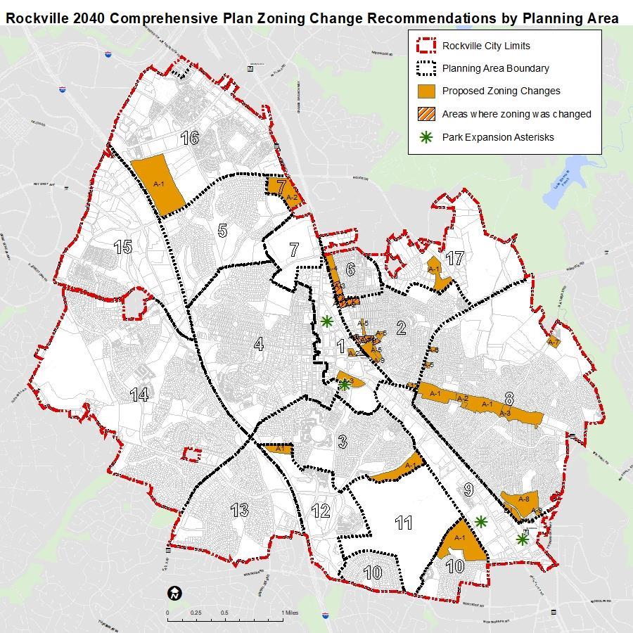
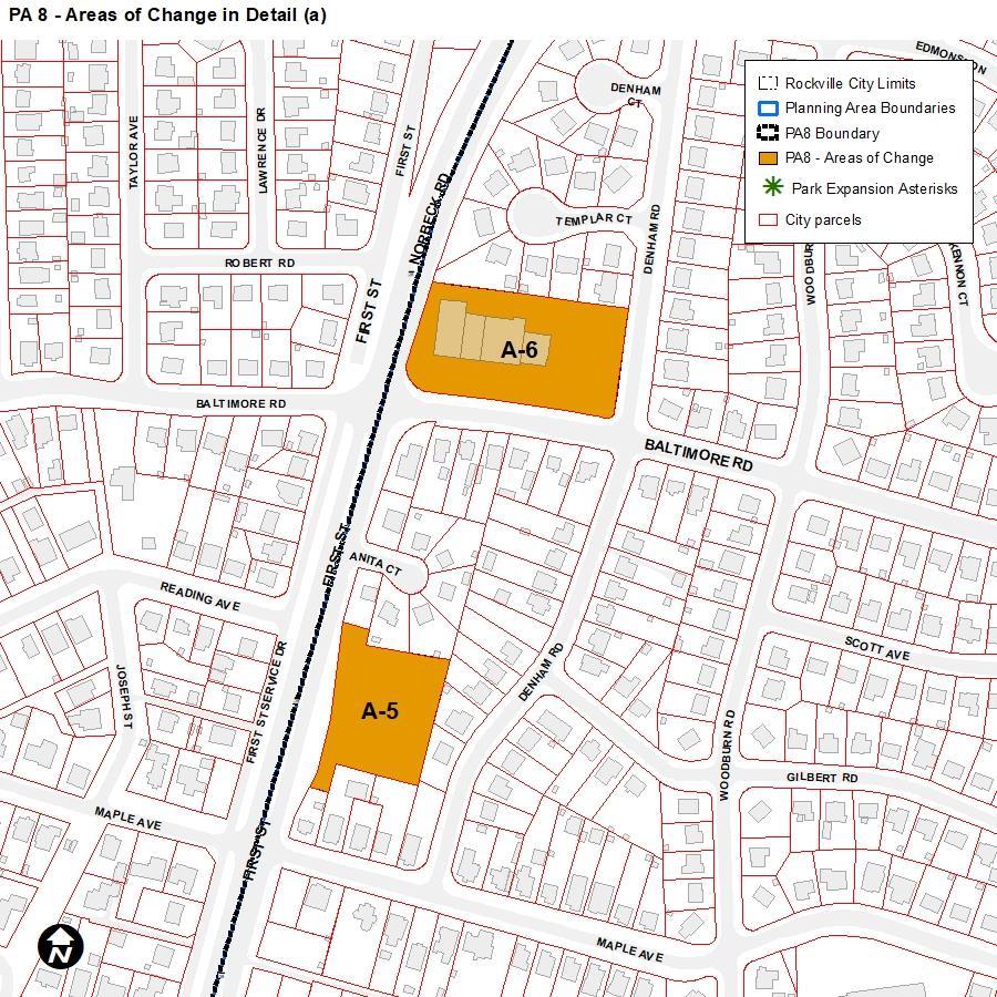
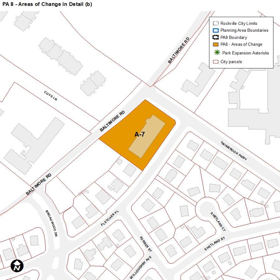
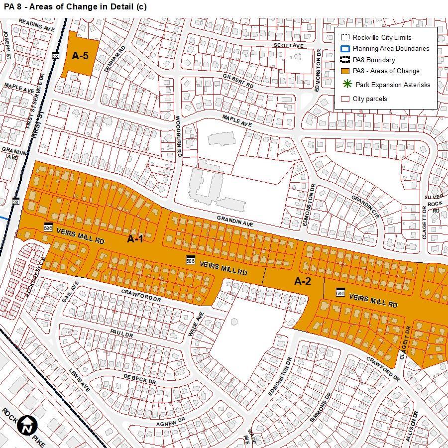
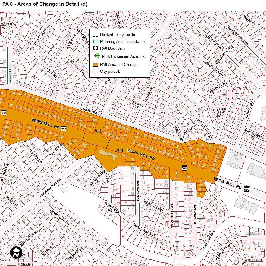
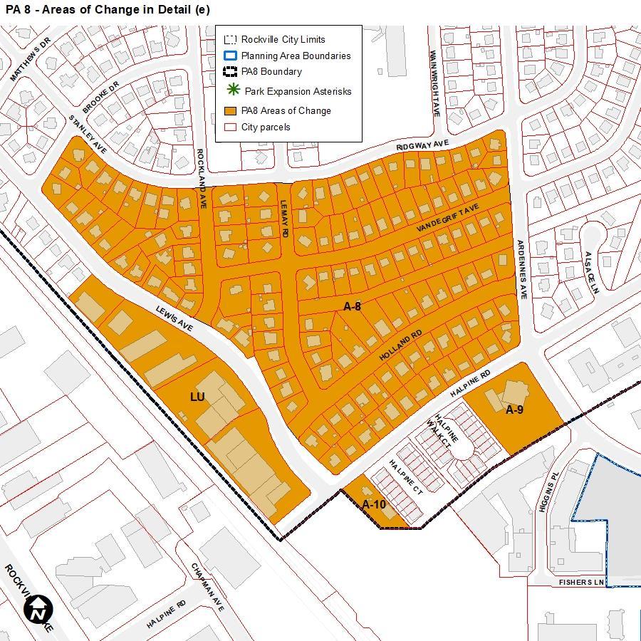
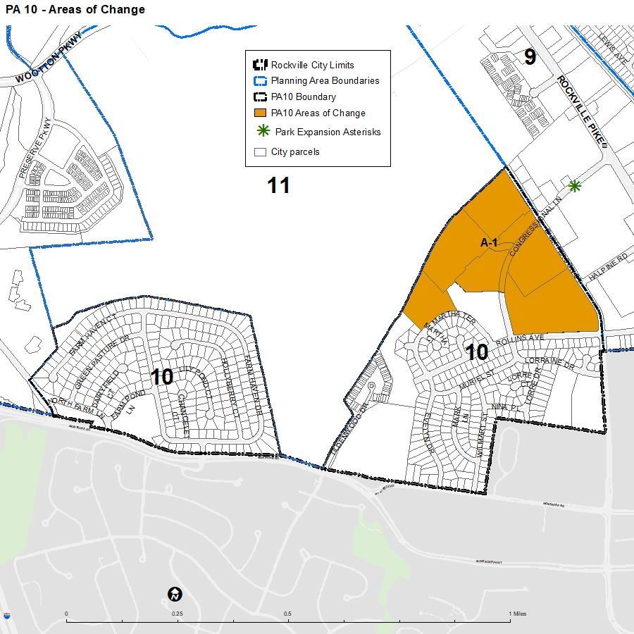
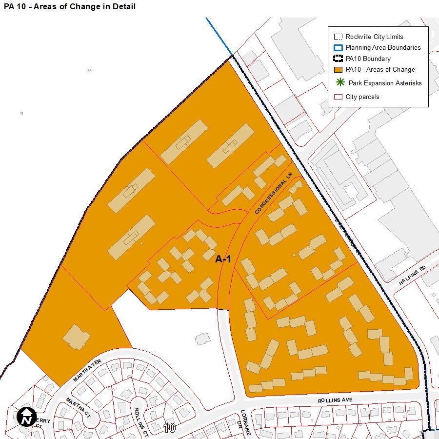
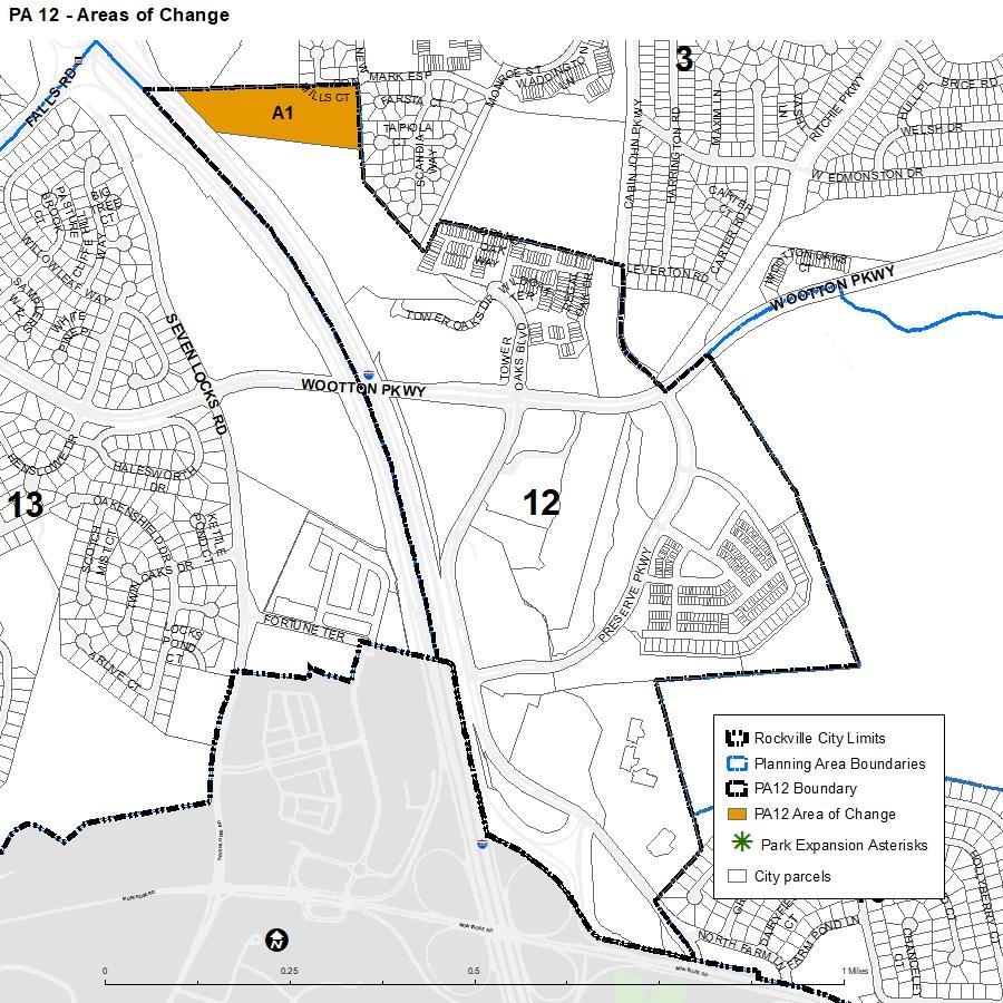
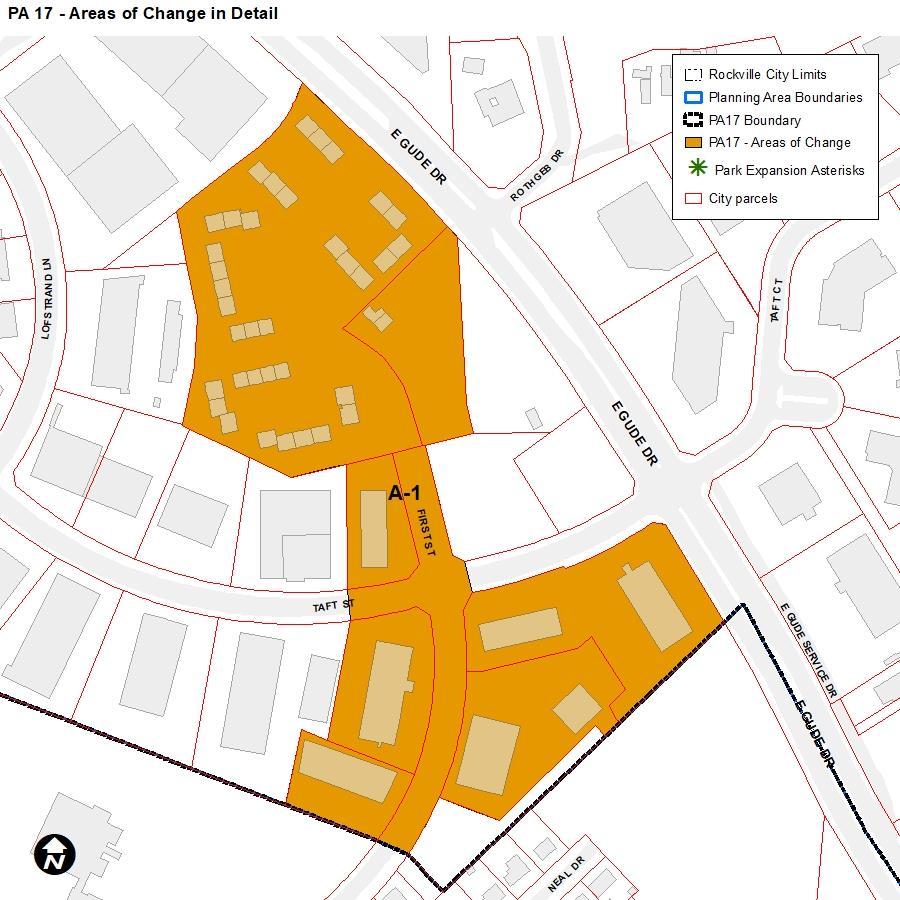
The tables below are organized by Planning Area, then focus area (which are units of spatial analysis in the plan), and plan goals and zoning recommendations are laid out simply for ease of review. See Attachment A for maps of the Planning Areas and specific parcels recommended for zone changes.
NOTE: Planning Area 1 will be replaced by the Town Center Master Plan update, which is in process and is anticipated for adoption in 2024. As a result, the policies and zoning recommendations below are likely to change. This information is provided for reference.
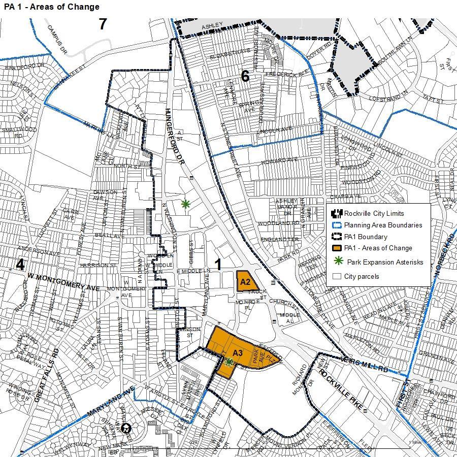
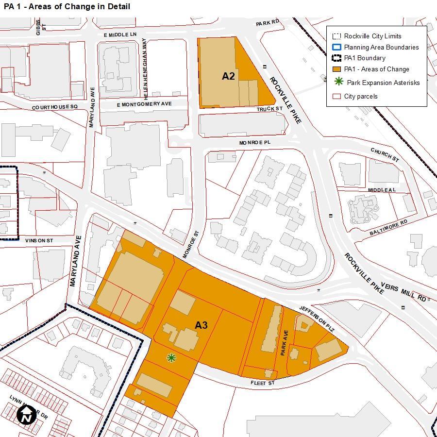
PLANNING AREA 1: Rockville Town Center
Recommendations pertain to “Uses,” “Development Standards,” “Design Standards,” or “General.”
Comprehensive Plan Zoning Recommendations Specifically for Planning Area 1
A# = Indicates the focus area that the recommendation applies to, which are also numbered in the Comprehensive Plan within each Planning Area
All of PA1: Provide an environment conducive to and supportive of living, working, shopping, and entertainment.
Status and Zoning District Recommendation
Uses
All of PA1: In order to serve Economic Development goals, several recommendations were put forth pertaining to uses: retain employers, recruit forprofit and non-profit employers especially for locations around transit, attract anchors that bring traffic/patrons, attract cultural centers, and remove regulatory barriers for desired uses.
A03: Continue development of the Lshaped ‘spine’, extending along East Montgomery Avenue and Maryland Avenue, with a mix of ground-floor commercial, service, and entertainment uses; and office, residential, and institutional uses located above.
A1: Given its close proximity to the core of Town Center, this area is planned for a mix of uses under the
Within PA1, where the MXNC, MXTD, MXCD zones are located, ensure that uses are evaluated to include the flexible and modern uses conducive to work, live, shop, play environment.
Within PA1, where the MXNC, MXTD, MXCD zones are located, ensure that the use table is updated to reflect modern employers like the biotechnology and tech companies drawn to Rockville, especially those compatible with commercial and residential uses. Consider simplifying the approval process to make the city more attractive to these types of uses.
The “spine” concept is not planned to be carried forward into the 2024 Plan. Explore other street-oriented uses that may contribute to this goal but not fit within the broad use categories.
Ensure that the MXNC within A1 can accommodate a mix of residential, employment, and commercial uses. As
Recommendations pertain to “Uses,” “Development Standards,” “Design Standards,” or “General.”
PLANNING AREA 1: Rockville Town Center
Comprehensive Plan Zoning Recommendations Specifically for Planning Area 1
A# = Indicates the focus area that the recommendation applies to, which are also numbered in the Comprehensive Plan within each Planning Area
Status and Zoning District Recommendation land use designation of OCRM (Office Commercial Residential Mix). Residential uses are particularly desired for this area, though development should be sensitive to the historic buildings and residents immediately to the west.
A1: Services and cultural/educational institutions are encouraged, as are commercial uses if the market supports them.
A4: Building frontages should include ground-floor uses that attract customers or regular visitors, enhanced pedestrian areas and amenities, attractive landscaping, and bicycle infrastructure.
recommended in other sections, explore a cohesive section for design guidelines which respect areas with historic urban fabric.
All of PA1: Provide sufficient parking for new mixed-use development and visitors to the Town Center.
Additional institutional/cultural uses should be changed to by-right permissions in the MXNC.
Existing standards require retail or service uses on the ground floor along the ‘pedestrian spine’ within Town Center. Within Town Center.
Provide incentives for ground floor non-residential uses within other areas of the MXCD ensuring that it does not conflict with housing objectives (or create an excess of leasable space)
Although parking for persons with disabilities should always be accommodated, consider the removal of parking minimums in Town Center and around Rockville Station in coordination with the Town Center Master Plan Update project.
A1: The current zoning for most of these properties is MXNC (Mixed Use Neighborhood Commercial), which limits building heights to 45 feet, with
Height maximums should remain the same in the MXNC. Consider revising incentives for additional height in
Recommendations pertain to “Uses,” “Development Standards,” “Design Standards,” or “General.”
PLANNING AREA 1: Rockville Town Center
Comprehensive Plan Zoning Recommendations Specifically for Planning Area 1
A# = Indicates the focus area that the recommendation applies to, which are also numbered in the Comprehensive Plan within each Planning Area
an opportunity to build somewhat taller based on providing such community needs as additional parks or open space and/or affordable housing. No change in height limits is recommended, though adjustments to the incentives for permitting additional height should be addressed.
Development & Design Standards
A05: Buildings with ground-level parking and blank building walls should not be allowed along street edges, especially along Maryland Avenue, East Middle Lane, North Washington Street, Courthouse Square, and East Montgomery Avenue.
A06: Streets in Town Center should be designed to encourage interaction and activity for people on the sidewalk, through the provision of wide sidewalks, gathering places, and interesting ground-floor uses. Sidewalk activity, such as outdoor café seating and other retail displays visible from the street, should be encouraged.
All of PA1: Utilize urban design to establish zoning and density requirements that will assist in defining the Rockville Town Center.
Status and Zoning District Recommendation
coordination with the Town Center Master Plan Update project.
Existing MX design standards require façade treatment and screening for parking structures. All of Town Center should have design standards that mandate cladding and shielding for parking structures.
Zoning in Town Center should have setback maximums with exceptions for ancillary uses like patios that activate the streetscape.
Design guidelines and standards exist for all of the MX zones, and some of them apply specifically within Town Center. Review the existing design guidelines and standards to verify that they are resulting in the desired outcomes.
Recommendations pertain to “Uses,” “Development Standards,” “Design Standards,” or “General.”
PLANNING AREA 1: Rockville Town Center
Comprehensive Plan Zoning Recommendations Specifically for Planning Area 1
A# = Indicates the focus area that the recommendation applies to, which are also numbered in the Comprehensive Plan within each Planning Area
A1: Buildings facing North Washington Street, as well as the public realm of sidewalks and amenities, should be designed to facilitate interaction and interest at the ground level, where they interact with a redesigned North Washington Street.
A1: On the west side of this area, buildings should be designed so as not to dominate the scale of the single-unit detached homes or commercial structures immediately to the west; designs should be sensitive to the views that those structures will have of new buildings.
A2: It is recommended that the city take an active role in the redevelopment of this area [255 Rockville Pike] as a prominent site in Rockville’s downtown. Redevelopment of this property should contribute to the realization of the Town Center downtown L-shaped ‘spine’ and incorporate an expanded pedestrian promenade over MD 355 to the Rockville Transit Station [Prioritize pedestrian-oriented design].
A3: New developments should orient primary building facades and front doors toward a street or public open space to frame the edges of streets, parks, and open spaces, and to foster activated pedestrian areas. Building frontages should include ground-floor
Status and Zoning District Recommendation
These requirements exist as guidelines for development in the MX zones. Within the MXNC, consider developing language for form-based standards that activate the public realm (pedestrian projections, transparency, façade variation, etc.)
Layback slope requirements exist in the MX zones. Consider establishing step-down or similar requirements for buildings abutting zones with lower height allowances.
This site is within the PD-RCI zone, which includes PD-specific design and development standards.
No further zoning changes recommended.
A3 is largely comprised of the MXCT zone. Design guidelines/standards for the MX zones exist. Review these standards and consider whether additional language for form-standards that activate the public realm (pedestrian
Recommendations pertain to “Uses,” “Development Standards,” “Design Standards,” or “General.”
PLANNING AREA 1: Rockville Town Center
Comprehensive Plan Zoning Recommendations Specifically for Planning Area 1
A# = Indicates the focus area that the recommendation applies to, which are also numbered in the Comprehensive Plan within each Planning Area
uses that attract customers or regular visitors, enhanced pedestrian areas and amenities, attractive landscaping, and bicycle infrastructure.
A4: Redevelopment of property in this area should contribute toward a pedestrian-oriented, urban-scale streetscape. New developments should orient primary building facades and front doors toward a street or public open space to frame the edges of streets, parks, and open spaces, and to foster activated pedestrian areas.
A2: Increase the number of residents and housing density in Town Center, to provide additional housing options for residents across the full range of income levels and to provide additional demand for the commercial uses in this mixed-use environment.
A3: The current zoning for these properties is MXNC (Mixed Use Neighborhood Commercial) in the portion north of Fleet Street and MXT (Mixed Use Transition) south of Fleet Street. A change in zoning to MXCT (Mixed Use Corridor Transition) is recommended for all properties within this focus area in order to permit heights of up to 75 feet.
Status and Zoning District Recommendation
projections, transparency, façade variation, etc.) is needed.
A4 is largely comprised of the MXCD zone. Design guidelines/standards for the MX zones exist. Review these standards and consider whether additional language for form-standards that activate the public realm (pedestrian projections, transparency, façade variation, etc.) is needed.
Existing incentives for affordable units and MPDUs should be implemented through consultation with builders.
Apply the MXCT zone to these properties. The MXCT zone permits heights up to 75 feet.
Where the MXCT abuts lower density zones, evaluate existing layback slope requirements and/or consider built-in height transitions (such as stepdowns)
Recommendations pertain to “Uses,” “Development Standards,” “Design Standards,” or “General.”
PLANNING AREA 1: Rockville Town Center
Comprehensive Plan Zoning Recommendations Specifically for Planning Area 1
A# = Indicates the focus area that the recommendation applies to, which are also numbered in the Comprehensive Plan within each Planning Area
A4: No zoning changes are recommended for the properties in this area, which are all zoned MXCD (Mixed Use Corridor District) with the exception of 255 N. Washington Street, which is in the planned development zone, PDKSI.
A4: A future public park is recommended in the general location where the green asterisk is placed on the Land Use Policy Map.
Status and Zoning District Recommendation
No changes recommended.
Recommendations pertain to “Uses,” “Development Standards,” “Design Standards,” or “General.”
Uses
Consider approaches to acquiring a public park as part of future development.
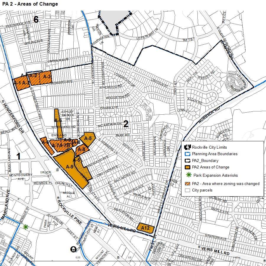
PLANNING AREA 2: East Rockville
Comprehensive Plan Zoning Recommendations Specifically for Planning Area 2
A# = Indicates the focus area that the recommendation applies to, which are also numbered in the Plan within each Planning Area
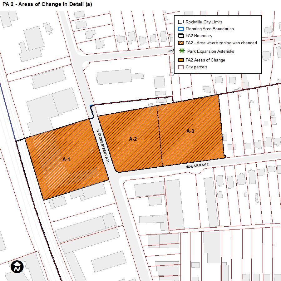
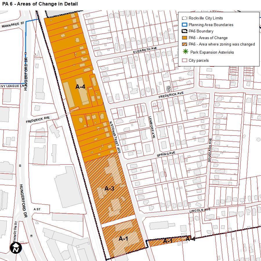
A1: Rezone the property from R-60 (Single Unit Detached Dwelling) to a mixed-use zone that allows for uses including multi-unit residential, commercial, spaces for artists and makers, and community facilities.
A2: Rezone the property from R-60 (Single Unit Detached Dwelling) to a neighborhood-scale mixed-use zone that allows a mix of residential and limited commercial.
Status and Zoning District Recommendation
Complete.
A1 was rezoned to MXCT as part of the Stonestreet Corridor map and Text Amendment in 2021 (MAP202100120).
Complete.
A2 was rezoned to MXNC as part of the Stonestreet Corridor map and Text Amendment in 2021 (MAP202100120).
PLANNING AREA 2:
East Rockville Recommendations pertain to “Uses,” “Development Standards,” “Design Standards,” or “General.”
Comprehensive Plan Zoning Recommendations Specifically for Planning Area 2
A# = Indicates the focus area that the recommendation applies to, which are also numbered in the Plan within each Planning Area
A3: Rezone the property from R-60 (Single Unit Detached Dwelling) to a zone specifically designed for infill residential.
Status and Zoning District Recommendation
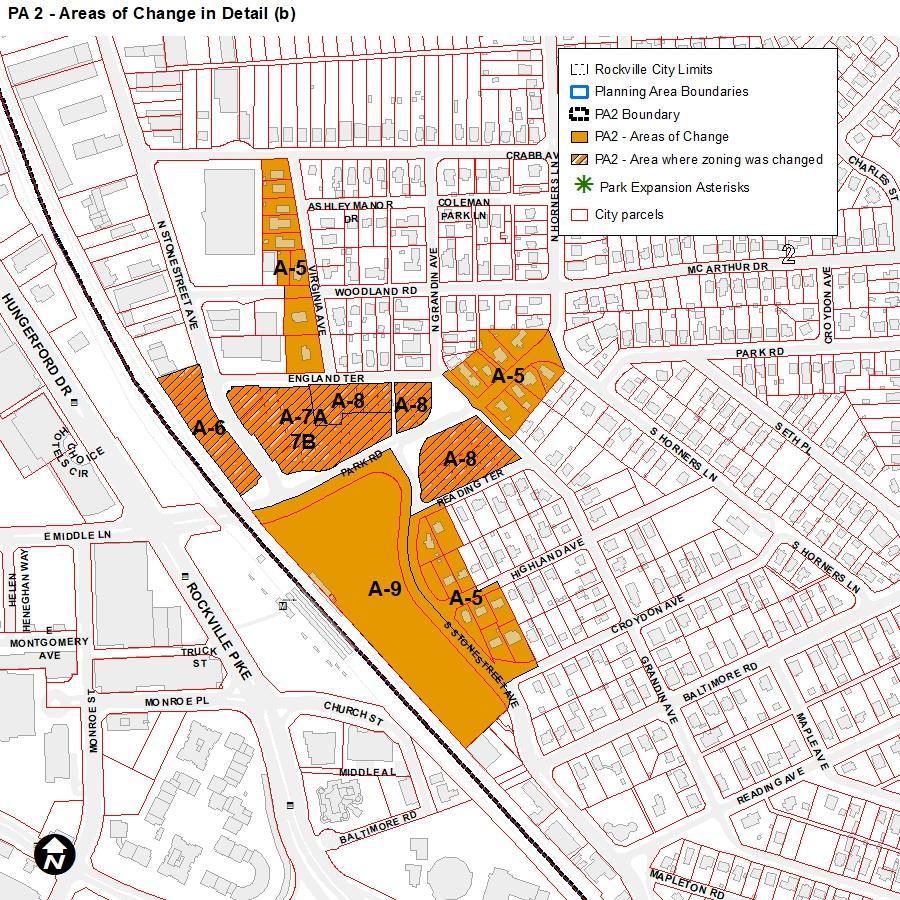
A4: The MXB zone is mapped in areas where service industrial is currently the main use, but allowing the incorporation of residential, commercial, office, and other uses within the area is desired. [Given that many of these uses are permitted in MXB], the properties within these areas are zoned MXB (Mixed-Use Business). No change to the zoning is recommended.
A5: Rezone the properties in this area from R-60 (Single Unit Detached Dwelling) to a new zone that allows a diverse range of housing types, including duplexes, triplexes, fourplexes, and row houses, in addition to single-unit detached dwellings. Fourplexes should only be allowed on corner lots in the zone. Multiplexes of greater than four units are not appropriate in this area.
Complete.
A3 was rezoned to RMD-10 as part of the Stonestreet Corridor map and Text Amendment in 2021 (MAP202100120).
No recommended changes.
Rezone the R-60 in A5 to the RMD-Infill, a new zone that was adopted as part of the Stonestreet Corridor map and Text Amendment in 2021 (MAP2021-00120).
A6: Rezone the properties from MXB (Mixed-Use Business) to a mixed-use zone that allows for uses including retail, office, neighborhood services, and artisan/craft manufacturing with Complete.
A6 was rezoned to MXNC as part of the Stonestreet Corridor map and Text Amendment in 2021 (MAP202100120).
PLANNING AREA 2:
East Rockville Recommendations pertain to “Uses,” “Development Standards,” “Design Standards,” or “General.”
Comprehensive Plan Zoning Recommendations Specifically for Planning Area 2
A# = Indicates the focus area that the recommendation applies to, which are also numbered in the Plan within each Planning Area
building heights up to 4-5 stories (or 50-65 ft).
A7a: Rezone the properties from MXB (Mixed-Use Business) to a mixed-use zone that promotes a mix of local retail and service uses and multi-unit residential across from the Rockville Metro Station with building heights up to 4-5 stories (or 50-65 ft).
A7b: Rezone the properties from R-60 (Single Unit Detached Dwelling) to a mixed-use zone that promotes a greater mix of uses, including smallerscale multi-unit residential, attached townhouses/row houses, and limited commercial at this transit center.
A8: Rezone the properties from R-60 (Single Unit Detached Dwelling) to a zone that promotes a mix of infill housing types, compatible in scale with single-family homes, including duplexes, triplexes, fourplexes, and townhouses/row houses. Multiplexes of greater than four units are not appropriate in this area.
A9: Rezone the properties from MXNC (Mixed-Use Neighborhood Commercial) to MXCD (Mixed-Use Corridor District) to allow for higher intensity transit-oriented development if the parking lot is proposed for redevelopment.
Status and Zoning District Recommendation
Complete.
A7a was rezoned to MXNC as part of the Stonestreet Corridor map and Text Amendment in 2021 (MAP202100120).
Complete.
A7b was rezoned to MXNC as part of the Stonestreet Corridor map and Text Amendment in 2021 (MAP202100120).
Complete.
A8 was rezoned to RMD-Infill, a new zone that was adopted as part of the Stonestreet Corridor map and Text Amendment in 2021 (MAP202100120).
Rezone to MXCD and also ensure that there are effective incentives to construct structured parking in this location given its proximity to Rockville Station.
PLANNING AREA 2: East
Comprehensive Plan Zoning Recommendations Specifically for Planning Area 2
Rockville Recommendations pertain to “Uses,” “Development Standards,” “Design Standards,” or “General.”
Status and Zoning District Recommendation
Standards
Development & Design
A# = Indicates the focus area that the recommendation applies to, which are also numbered in the Plan within each Planning Area
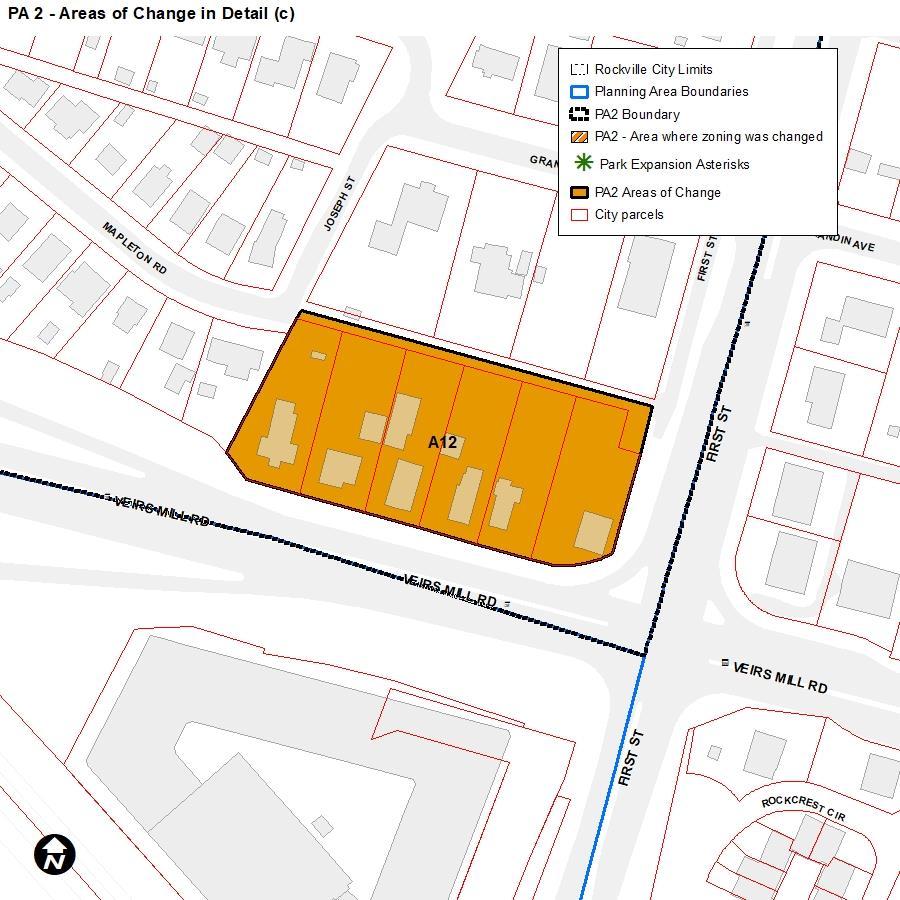
A12: Rezone the properties from R-60 (Single Unit Detached Dwelling) to a new zone that allows a diverse range of housing types, including duplexes, triplexes, fourplexes, and townhouses/row houses, in addition to single-unit detached dwellings. Multiplexes of greater than four units are not appropriate in this area.
A5: The visibility and prominence of parking facilities should be minimized. Parking at the rear or to the side of the building is encouraged. Front yard pavement should be minimized as much as possible and permeable paving materials are highly encouraged throughout the site.
A9: Rezone the properties from MXNC (Mixed-Use Neighborhood Commercial) to MXCD (Mixed-Use Corridor District) to allow for higher intensity transit-oriented development if the parking lot is proposed for redevelopment.
A1, A2, A3: Provide sensitively scaled transitions between new development and existing neighborhood homes.
Rezone the R-60 in A12 to the RMD-Infill, a new zone that was adopted as part of the Stonestreet Corridor map and Text Amendment in 2021 (MAP2021-00120).
A1, A2, A3: In general, orient the primary facades of buildings and front
The East Rockville Design Guidelines minimize paving and parking facilities at the front of structures. Throughout the zoning code, incentives for permeable pavers should be developed. Consider implementing this recommendation City-wide.
Rezone the MXNC in the A9 to MXCD prior to development.
Where consideration is being given to rezonings for mixed-use, add height buffers standards to the new district to mitigate incompatible form with residential properties. These standards already exist in the existing mixed-use districts.
Development design standards for attached residential, nonresidential, and
PLANNING AREA 2:
East Rockville Recommendations pertain to “Uses,” “Development Standards,” “Design Standards,” or “General.”
Comprehensive Plan Zoning Recommendations Specifically for Planning Area 2
A# = Indicates the focus area that the recommendation applies to, which are also numbered in the Plan within each Planning Area
doors parallel to the street or to a public open space to frame the edges of streets, parks, and open spaces, and to activate pedestrian areas.
A1, A2, A3: Incorporate accessible community use space, including parks and other contiguous outdoor green space into the overall redevelopment concept.
A1, A2, A3: In general, parking areas should be set back behind front building lines, away from the public realm and screened from public view. New structured parking should be located internal to new development. For attached dwellings, rear garage access is preferred, whether the garage is integrated into the primary structure or whether it is a separate structure; front-loaded garages should be avoided.
A4: Multiple properties with service industrial uses about properties with residential dwellings. Sensitively scaled transitions (heights, facade articulation, etc.) and ample screening between new development and existing neighborhood homes should be provided.
A9: Provide sensitively scaled transitions between new development and existing neighborhood homes.
Status and Zoning District Recommendation
mixed-use development and apply them citywide.
The project team should confer on changing the standards around public use space to ensure that Plan objectives are being met. Additional information is needed and there are no recommendations at this time.
A1, A2, and A3 have been rezoned per the recommendations of this Planning Area. Standards for parking area screening and location should be developed or refined for all MX and RMD zones.
Add additional setbacks for height and mandatory screening to the MXB zone.
Add additional setbacks for height and mandatory screening to the MXNC zone.
PLANNING AREA 2: East
Rockville Recommendations pertain to “Uses,” “Development Standards,” “Design Standards,” or “General.”
Comprehensive Plan Zoning Recommendations Specifically for Planning Area 2
A# = Indicates the focus area that the recommendation applies to, which are also numbered in the Plan within each Planning Area
A9: New structured parking or parking garages should be located internal to new development and be oriented so as not to face the public street or adjacent residential homes.
A6-8: There were several recommendations for urban design standards including tapering buildings down when adjacent to single-family homes, full cut-off for outdoor lighting, establish building frontages along Park Road and North Stonestreet Avenue to include ground-floor commercial, enhanced pedestrian areas and amenities, landscaping, and bicycle infrastructure, incorporate community space into redevelopment.
Status and Zoning District Recommendation
A10-11: There are several urban design objectives including incorporating community gathering space into development, framing the street corner with commercial uses to activate pedestrian areas and create an inviting focal point through unique and interesting design, providing sensitively scaled transitions between new development and existing neighborhood homes.
The proposed MXCD zone should minimize paving and parking facilities at the front of structures. Throughout the zoning code, incentives for permeable pavers should be developed.
A8 has been rezoned to RMD-Infill, which does not permit commercial uses. A6 and A8 have been rezoned to MX zones, which permits ground floor commercial and requires buildings to be placed near the street. Citywide development standards require cut-off for outdoor lighting, pedestrian areas and amenities, landscaping, and bicycle infrastructure to be provided with development.
Metrics for and design of community space should be developed during the next phase of the project.
No change is recommended for the MXNC zone given that most of these objectives are met within this zone.
PLANNING AREA 3:
Hungerford, New Park Commons, Lynfield, and Fireside Park Recommendations pertain to “Uses,” “Development Standards,” “Design Standards,” or “General.”
Uses
Comprehensive Plan Zoning Recommendations Specifically for Planning Area 3
A# = Indicates the focus area that the recommendation applies to, which are also numbered in the Plan within each Planning Area
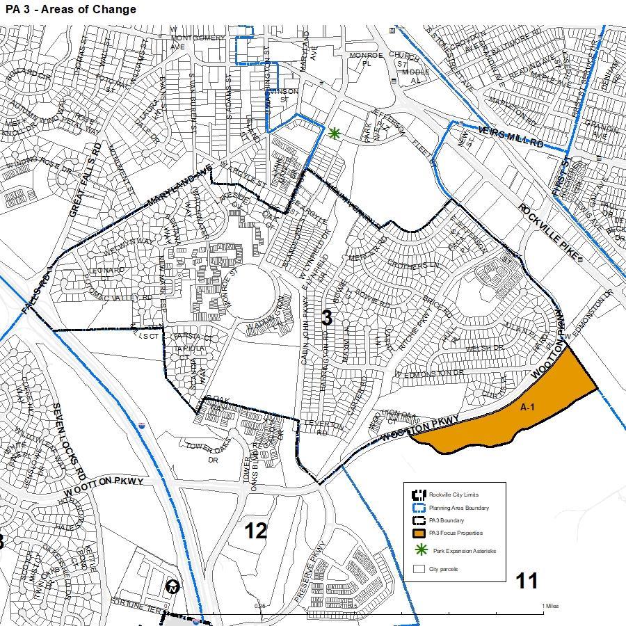
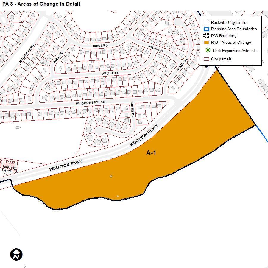
A1: Allow future rezoning of the 27acre Wootton Parcel from R-400 (Residential Estate) to RMD-25 (Residential Medium Density) or a similar zone that is consistent with the range of housing types of the RF land use designation.
Status and Zoning District Recommendation
Development & Design Standards
All of PA3: Maintain residential character of the planning area and consider the creation of residential design guidelines that include a residential facade improvement program to improve aging housing stock. Guidelines should include standards to avoid “mansionization” and incompatible residential styles.
The RF land use designation describes a range of housing including a mix of townhouses/row houses, apartment buildings, and detached houses. Smallscale commercial uses are an included option if integrated into the residential development.
Evaluate whether the RMD-25 zone will implement this designation or if revisions are needed.
“Residential character” should be maintained through consistent use permissions, though the use of the term “character” should be deleted and replaced with clearly understood descriptions of the physical community characteristics to be protected.
Develop design standards for single detached zones and apply them citywide.
All of PA3: Consider enlarging the Dawson Farm Houses Local Historic District boundary to include the adjacent city owned Dawson Farm Park property, which is listed on the National Register of Historic Places, but not currently designated as a local historic district.
No zoning recommendation.
HDC will consider designation and make a recommendation to Mayor and Council.
PLANNING AREA 4:
West End and Woodley Gardens East-West Recommendations pertain to “Uses,” “Development Standards,” “Design Standards,” or “General.”
Comprehensive Plan Zoning Recommendations Specifically for Planning Area 4
A# = Indicates the focus area that the recommendation applies to, which are also numbered in the Plan within each Planning Area
All of PA4: Explore the impacts of revising the zoning ordinance to permit only single-unit detached homes, duplexes, and residential townhouses for the block of townhouses on the east side of the 200 block of North Adams Street, north of Beall Avenue. The townhouse communities at Courthouse Walk, Rose Hill, Rose Hill Falls, and Cambridge Cluster (Martins Square Lane) are not expected to redevelop during the life of this plan (estimated to be approximately 20 years). They are identified as Residential Attached on the Land Use Map and should remain as townhouses.
Uses
All of PA4: The Dawson Avenue Apartments between North Van Buren Street and Forest Avenue are conducive to a wider range of Residential Attached housing and could be redeveloped with single-unit detached homes, similarly scaled multi-unit residential buildings (containing 6 or fewer units), duplexes, triplexes, fourplexes, stacked flats, or townhouses. Consideration must be given to good architectural design, massing and building heights that are compatible with existing nearby single-unit detached houses, and adequate offstreet parking so that the new development fits well into the surrounding residential neighborhood.
Status and Zoning District Recommendation
Consider applying an RMD zone to this area; the RMD-10, RMD-15, and RMD25 zones permit single detached, duplex, and townhouse dwellings along with multiple unit dwellings at various densities.
This area is currently zoned RMD-25, which permits a variety of housing types, with the exception of rowhouse dwellings. However, the number of dwelling units is limited to 25 du/acre with a minimum site area of 2 acres.
Consider whether this zone should be modified to allow smaller site area for more flexibility.
PLANNING AREA 4:
West End and Woodley Gardens East-West Recommendations pertain to “Uses,” “Development Standards,” “Design Standards,” or “General.”
Comprehensive Plan Zoning Recommendations Specifically for Planning Area 4
A# = Indicates the focus area that the recommendation applies to, which are also numbered in the Plan within each Planning Area
All of PA4: Allow multi-unit residential housing as a use in historic houses in limited transitional locations near Town Center, as indicated on the Land Use Policy Map (Figure 51), to provide opportunities for affordable market-rate housing.
All of PA4: Establish a new zone to implement the Residential and/or Office (RO) land use designation that reflects the limited land uses (residential and/or office only) for properties in Planning Area 4 along its border with Planning Area 1 (Town Center).
All of PA4: Explore the impacts of amending zoning for all properties currently in the MXT zone within Planning Area 4, except for those that abut North Adams Street between West Jefferson Street and West Montgomery Avenue (4, 10, 12, and 14 South Adams Street and 101 West Jefferson Street) as shown in Figure 52, so as not to allow retail uses, but to allow office uses and both single-unit detached and multi-unit residential uses. This could be achieved via a new zone or an overlay district.
The five properties outlined in red in Figure 52 (one of which is a commercial retail use now) would allow, in addition to residential and office uses, limited small, neighborhood-serving retail uses, as described above,
Status and Zoning District Recommendation
Broader use allowances can encourage the designation of historic properties and support their maintenance. Develop unique use provisions for houses within historic districts that allow multi-unit residential housing by right.
Develop a new zone or overlay for this area.
Rather than revise the MXT use standards for the whole city, an overlay zone may be an appropriate approach. As noted above, there are a number of recommended revisions to the MXT zone that will need to be evaluated and balanced.
PLANNING AREA 4:
West End and Woodley Gardens East-West Recommendations pertain to “Uses,” “Development Standards,” “Design Standards,” or “General.”
Comprehensive Plan Zoning Recommendations Specifically for Planning Area 4
A# = Indicates the focus area that the recommendation applies to, which are also numbered in the Plan within each Planning Area
if they are determined to have no adverse impacts in terms of traffic, parking, or erosion of the historic, residential character of the block.
All of PA4: Promote the continued use and preservation of other historic buildings in the transition area adjacent to Town Center, listed in Table 1, by allowing use options including single-unit detached homes, multi-unit residential buildings, and business and professional offices, as long as the historic integrity of the exterior is preserved. … The land use designation of these buildings is Residential and/or Office on the Land Use Policy Map. Revise zoning to indicate the change from MXT zoning to a zone that reflects the Residential and/or Office (RO) land use designation.
All of PA4: Explore the impacts of amending the Zoning Ordinance to limit the number of Major homebased businesses allowed within a concentrated geographic area.
All of PA4: Explore the impacts of amending the findings required for a Special Exception to indicate that there is a presumption that the residential character of the neighborhood would be changed if the number of Major home-based businesses on any residential block exceeds 25% of the
Status and Zoning District Recommendation
Develop a new zone or overlay for this area.
This type of limitation could have broad-reaching equity implications and will need to be carefully evaluated.
This action would require an amendment to the approval criteria for Special Exceptions. The project team will further evaluate this recommendation during the next phase.
PLANNING AREA 4:
West End and Woodley Gardens East-West Recommendations pertain to “Uses,” “Development Standards,” “Design Standards,” or “General.”
Comprehensive Plan Zoning Recommendations Specifically for Planning Area 4
A# = Indicates the focus area that the recommendation applies to, which are also numbered in the Plan within each Planning Area
residences on that block. This policy applies to Planning Area 4 and may be accomplished by creating an overlay zone.
All of PA4: Explore the impacts of amending the Zoning Ordinance to prohibit Major home-based businesses in residences that share a driveway with a neighboring residence, unless the owners of all residences that share the driveway are supportive.
All of PA4: Review and explore amending Special Exception and Conditional Use provisions in the Zoning Ordinance to ensure that they prevent cumulative, undesirable consequences that are incompatible with residential neighborhoods, such as extensive aggregation of land for expansion, increased vehicular traffic, and reduced pedestrian safety.
All of PA4: Explore the impact of limiting the number of children allowed, or increasing the minimum lot area, for Special Exceptions for a home-based or center-based child care facility when that home or center is adjacent to residences in single-dwelling unit residential zones. Explore the impacts of amending the findings required for a Special Exception to indicate that if the number of child care centers exceeds 15% of the residences on a
Status and Zoning District Recommendation
This action would require an amendment to the approval criteria for Special Exceptions. The project team will further evaluate this recommendation during the next phase.
Undesirable consequences would need to be clearly identified and quantified in order to be supportable. The project team will further evaluate this recommendation during the next phase.
Any limitations will need to be balanced against equity and livability considerations.
The APA Equity in Planning Policy Guide notes that “…serious shortages of convenient childcare have a disproportionate impact on single-parent, often female-headed, households.”
PLANNING AREA 4:
West End and Woodley Gardens East-West Recommendations pertain to “Uses,” “Development Standards,” “Design Standards,” or “General.”
Comprehensive Plan Zoning Recommendations Specifically for Planning Area 4
A# = Indicates the focus area that the recommendation applies to, which are also numbered in the Plan within each Planning Area
residential block, there is a presumption that the residential character of the neighborhood would be changed. This policy would apply to Planning Area 4 and may be accomplished by creating an overlay zone.
All of PA4: Explore amending the findings required for a Special Exception to indicate that if the total number of childcare centers and Major homebased businesses, combined, exceeds 25% of the residences on a residential block, there is a presumption that the residential character of the neighborhood would be changed.
All of PA4: Explore changing the underlying zone for the parcels currently owned or occupied by the Rockville United Methodist Church from MXT to a zone that would indicate the Residential and/or Office (RO) land use designation that would be compatible with the immediate neighborhood (residential and/or office, but not retail), although no change in use is anticipated for this historic church.
All of PA4: Allow Jefferson House, located at 111 West Jefferson Street, to continue operating as a personal living quarters or group home under any new zoning.
Status and Zoning District Recommendation
Any limitations will need to be balanced against equity and livability considerations.
The APA Equity in Zoning Policy Guide notes that “…serious shortages of convenient childcare have a disproportionate impact on single-parent, often female-headed, households.”
Consider developing a new zone for the RO land use designation and apply here and in other RO areas.
Group homes (8 residents or less) are permitted by right in all zones per state law. Personal living quarters are permitted in all of the MX zones. No change recommended.
PLANNING AREA 4:
West End and Woodley Gardens East-West Recommendations pertain to “Uses,” “Development Standards,” “Design Standards,” or “General.”
Comprehensive Plan Zoning Recommendations Specifically for Planning Area 4
A# = Indicates the focus area that the recommendation applies to, which are also numbered in the Plan within each Planning Area
IU 09: Explore changing the underlying zone for the parcels currently owned or occupied by the Rockville United Methodist Church from MXT to a zone that would indicate the Residential and/or Office (RO) land use designation that would be compatible with the immediate neighborhood (residential and/or office, but not retail).
LUZ 01-20: There are over a dozen recommendations for the MXT zone within the RO designation that apply to highly specific geographic areas. The project team will need to discuss how that level of geographic granularity can be captured within a single zoning district. For example, within the MXT, several of these small geographic areas call for retail, while others state that it should be prohibited.
All of PA4: Explore requiring screening from adjacent and abutting residential lots when modifications or additions to institutional properties are approved to accommodate or expand a Special Exception use to prevent negative impacts on the residences.
All of PA4: Home-based businesses may alter the historic character or incentivize alteration of historic architectural features.
Status and Zoning District Recommendation
Rezone the properties in question from MXT to a flexible residential district that permits offices and institutions.
Resolve the conflicting guidance for revisions to the MXT zone through accommodating some properties through rezoning or special use standards that would mitigate/accommodate the reasons for wanting to prohibit some uses.
The Landscaping, Screening, and Lighting Manual currently requires screening between institutional uses in residential zones and residentially zoned property. Retain these provisions in the rewrite.
The zoning code should provide more clarity around the types of alterations that are permissible for locally designated historic structures, with the intent of providing flexibility while not critically altering historic facets of the structure.
Recommendations pertain to “Uses,” “Development Standards,” “Design Standards,” or “General.”
PLANNING AREA 4: West End
and Woodley Gardens
Comprehensive Plan Zoning Recommendations Specifically for Planning Area 4
A# = Indicates the focus area that the recommendation applies to, which are also numbered in the Plan within each Planning Area
East-West
Status and Zoning District Recommendation
All of PA4: Develop design guidelines for single-unit detached housing, with the purposes of a) addressing potential adverse impacts of new structures and additions on abutting houses (such as reduction of access to sunlight, unhealthy noise levels, and loss of privacy), and b) preserving the existing character of the neighborhood.
The APA Equity in Zoning Policy Guide recommends:
Update home occupation regulations to broaden the types of activities allowed to be conducted from dwelling units of all types. Ensure that any restrictions on home occupations are based on documented neighborhood impacts and eliminate special permit requirements where possible.[…]
Develop design standards for single detached housing and apply them throughout the city.
Any reference to preserving existing character should be deleted and replaced with clearly understood descriptions of the physical community characteristics to be protected.
Standards that address massing, articulation, fenestration, and building location can ensure that new development is compatible with existing development.
All of PA4: The subdivision of parcels should not detract from the existing character of the surrounding neighborhood. Where a large property is being subdivided into smaller parcels, the new parcels should be similar in size to those in the immediate vicinity.
This is an existing subdivision requirement. However, requiring subdivided parcels to reflect existing lotting sizes and patterns can exacerbate inequity in development. As noted in Section 6.C of this report, the existing provision is recommended for removal.
Comprehensive Plan Zoning Recommendations Specifically for Planning Area 5
PLANNING AREA 5: Woodley Gardens and College Gardens Recommendations pertain to “Uses,” “Development Standards,” “Design Standards,” or “General.”
Status and Zoning District Recommendation
Uses
A# = Indicates the focus area that the recommendation applies to, which are also numbered in the Plan within each Planning Area
A1: This area is designated OSP (Open Space Private) in recognition of its primary current use as a private recreation facility. If this land use proves impractical, residential development consistent with the RD (Residential Detached) designation may be considered, due to its proximity to nearby residential homes.
A1: No zoning change is recommended to the existing R-90 (Single Unit Detached Dwelling, Restricted Residential) zone.
The current zoning of the Woodley Gardens Swim Club is R-90. No changes recommended.
Development & Design Standards
A1: If a private recreation/education use proves impractical, the property should redevelop into residential housing that is compatible in size, scale, and design with the surrounding neighborhood.
No change recommended.
Other 01: Maintain the residential character of the planning area.
New development on the site must comply with the R-90 zone standards.
“Residential character” should be maintained through consistent use permissions, though the use of the term “character” should be deleted and replaced with clearly understood descriptions of the physical community characteristics to be protected.
PLANNING AREA 6: Lincoln Park Recommendations pertain to “Uses,” “Development Standards,” “Design Standards,” or “General.”
Comprehensive Plan Zoning Recommendations Specifically for Planning Area 6
A# = Indicates the focus area that the recommendation applies to, which are also numbered in the Plan within each Planning Area
A1: Rezone the property from Single Unit Detached Dwelling (R-60) to a mixed-use zone that allows for uses including multi-unit residential, commercial, spaces for artists and makers, and community facilities.
A3: Rezone the property from Single Unit Detached Dwelling (R-60) to Residential Medium Density (RMD-15) or to a new zone specifically designed for infill residential to promote a mix of housing types, compatible in scale with the single-unit homes to the north and east, including townhouses and small multi-unit development.
Uses
A1-A3: Lincoln Park Neighborhood Conservation District (LPNCD)
Boundary Adjustment: In addition to property-specific recommendations, it is also recommended that the LPNCD boundary be amended to remove this area from the District since the LPNCD includes regulations geared toward single-unit detached development on individual lots rather than large-lot, non-residential parcels.
A4: Rezone the properties in this area from R-60 (Single Unit Detached Dwelling) to a new zone that allows a diverse range of housing types, including duplexes, triplexes, fourplexes, and row houses, in addition to single-unit detached dwellings.
Status and Zoning District Recommendation
Complete.
This property has been rezoned to MXCT.
Complete.
This property has been re-zoned to RMD-15.
LPNCD boundary will be amended through a separate process, to be coordinated with the ZOR.
Rezone the R-60 properties in A4 to a land use designation that permits middle housing by-right. The RMD-Infill zone may be appropriate here as it allows all of the listed housing types.
PLANNING AREA 6: Lincoln
Park Recommendations pertain to “Uses,” “Development Standards,” “Design Standards,” or “General.”
Comprehensive Plan Zoning Recommendations Specifically for Planning Area 6
A# = Indicates the focus area that the recommendation applies to, which are also numbered in the Plan within each Planning Area
Fourplexes should only be allowed on corner lots in the zone. Multiplexes of greater than four units are not appropriate in this area.
A5: Rezone the property from its current industrial zoning (County Zoning IM-2.5) to a zone consistent with its land use designation. (Note: Re-zoning should be considered upon annexation)
A1-A3: Incorporate accessible community use space, including parks and other contiguous outdoor green space, into the overall redevelopment concept. In addition to connected and accessible open space within private developments, opening and enhancing public green and community space on the grounds of the former Lincoln High School/current church would provide a central gathering area for existing and future residents.
A5: If a residential use is developed, a contiguous, well-connected park or open space, usable to the public, should be provided on this property. The park should be comparable in size, at a minimum, to the Wilma Shelton Bell Park, located to the southeast of 1000 Westmore Avenue [1.1 acres].
Status and Zoning District Recommendation
Assess current land uses in the A5 and re-zone away from IM-2.5 (County Zoning) at the time of annexation.
Revise the current public/community use space policies in order to better meet City objectives and Comprehensive Plan goals.
Connect this goal back to the public use space policies if this could be accomplished through that policy or pursue this goal through the Recreation and Parks Department parkland equity standards at the time of annexation. This could be part of an annexation agreement.
PLANNING AREA 6:
Lincoln Park Recommendations pertain to “Uses,” “Development Standards,” “Design Standards,” or “General.”
Comprehensive Plan Zoning Recommendations Specifically for Planning Area 6
A# = Indicates the focus area that the recommendation applies to, which are also numbered in the Plan within each Planning Area
A5: If any non-residential uses are developed, the forest conservation easement should remain and continue to provide a significant buffer to the existing residences to the south. Should a residential use be proposed, development should be contingent on the Montgomery County Planning Board approving the Forest Conservation Easement being flipped to the north side of the site, and the development being focused to the south on Ashley Avenue to buffer any new residential from the industrial uses to the north. This Plan does not recommend approving isolated residential development adjacent to industrial uses.
A1-A3: Neighborhood Transitions: Orient maximum building heights along North Stonestreet Avenue, away from the existing single-unit residential.
New buildings should taper down in height and scale toward existing single-unit homes to establish a compatible relationship between buildings.
Status and Zoning District Recommendation
A1-A3: In general, orient the primary facades of buildings and front doors parallel to the street or to a public open space to frame the edges of streets, parks, and open spaces, and to activate pedestrian areas.
If a residential use is proposed, work with the developer to pursue a forest conservation easement to the north of the site at the time of annexation.
For A1, height at the street in the MXCT zone is limited to 50 ft. For A3, the height in the RMD-15 zone is limited to 40 ft. The maximum height in the R-60 zone to the east is 35 ft. Evaluate existing standards and adjust as necessary.
Evaluate existing layback slope requirements of Sec. 25.13.05 and consider whether to retain, revise, or replace.
Design standards for attached dwellings, non-residential and mixed-use developments should be developed and applied citywide.
PLANNING AREA 6: Lincoln
Park Recommendations pertain to “Uses,” “Development Standards,” “Design Standards,” or “General.”
Comprehensive Plan Zoning Recommendations Specifically for Planning Area 6
A# = Indicates the focus area that the recommendation applies to, which are also numbered in the Plan within each Planning Area
A1-A3: Create an architectural feature at the corner of North Stonestreet Avenue and Howard Avenue by focusing new development at that intersection, incorporating high-quality design features, and enhancing the public realm.
A1-A3: In general, parking areas should be set back behind front building lines, away from the public realm and screened from public view.
A1-A3: For attached dwellings, rear garage access is preferred, whether the garage is integrated into the primary structure or whether it is a separate structure; front-loaded garages should be avoided.
Status and Zoning District Recommendation
A1-A3: Mitigate impacts on new development, particularly residential developments, related to the area being proximate to the rail line.
Design standards for attached dwellings, non-residential and mixed-use developments should be developed and applied citywide.
A4: Buildings should be designed and oriented in a manner that is inviting, promotes walkability, and contributes
Design standards for attached dwellings, non-residential and mixed-use developments should be developed and applied citywide.
Design standards for attached dwellings and mixed-use developments should be developed and applied citywide.
For A1, the MXCT zone requires buildings to be located at the front property line and limits access to commercial development from the rear or side street. This provision should be expanded to all allowed development types.
Develop general buffering standards for rail lines and other heavy infrastructure.
Development in the MX zones is subject to a noise mitigation plan.
The Lincoln Park Design Guidelines are in process and will address these recommendations for single detached dwellings.
PLANNING AREA 6:
Lincoln Park Recommendations pertain to “Uses,” “Development Standards,” “Design Standards,” or “General.”
Comprehensive Plan Zoning Recommendations Specifically for Planning Area 6
A# = Indicates the focus area that the recommendation applies to, which are also numbered in the Plan within each Planning Area
Status and Zoning District Recommendation positively to the neighborhood context.
Porches or enhanced entryways are encouraged, and entrances should be oriented toward the street, connected by a walkway, to provide more opportunities for “eyes on the street” and community interaction.
The siting of new buildings should be consistent with the established setback pattern along the block. If too much variation exists between existing buildings, a new building should be placed in a manner that establishes a street presence and enhances neighborhood character.
Mature trees and tree canopy should be prioritized and preserved.
A4: Open spaces should be consolidated into larger usable areas and designed as an integral part of the project, rather than scattered throughout the site, rendering them unusable.
Design standards for attached dwellings and mixed-use developments should be developed and applied citywide.
A4: New residential attached buildings should be proportional in height, mass, and scale with adjacent homes and blend well into the existing neighborhood.
Develop metrics for open space that ensure it is functional (minimum dimensions, minimum amenities, etc.).
Revise the definition of open space to state that it must be contiguous, not scattered around a site in slivers.
The Lincoln Park Design Guidelines are in process and will address these recommendations for single detached dwellings.
Design standards for attached dwellings and mixed-use developments
PLANNING AREA 6: Lincoln
Park Recommendations pertain to “Uses,” “Development Standards,” “Design Standards,” or “General.”
Comprehensive Plan Zoning Recommendations Specifically for Planning Area 6
A# = Indicates the focus area that the recommendation applies to, which are also numbered in the Plan within each Planning Area
When adjacent to a lower-scaled structure, a gradual transition should be utilized. This recommendation can be accomplished through design elements, including stepping back upper stories, varying roof lines, recessing a portion of the wall plane, and lowering the roof pitch.
Side elevations should include windows of consistent proportion and placement as the front elevation. Large, blank walls should be avoided.
On corner lots, both facades should be similarly designed and detailed and have similar opening proportions, placements, and alignments.
A4: Parking considerations should be balanced between taking advantage of proximity to high capacity transit stops (existing and planned); keeping construction costs down by not requiring more parking than is needed at transit-proximate sites; and considering the surrounding neighborhood’s parking constraints, especially in areas with limited-to-no off-street parking.
The visibility and prominence of parking facilities should be minimized. Parking at the rear or to the side of the building is encouraged. Front yard pavement should be minimized as much as possible and permeable
Status and Zoning District Recommendation
should be developed and applied citywide.
If the RMD-Infill zone is applied to this area, development would be subject to special development and design standards to ensure articulation.
If the RMD-Infill zone is applied to this area, development would be subject to special parking lot design and placement requirements that require parking to be placed to the side or rear of buildings.
PLANNING AREA 6:
Comprehensive Plan Zoning Recommendations Specifically for Planning Area 6
Lincoln Park Recommendations pertain to “Uses,” “Development Standards,” “Design Standards,” or “General.”
Status and Zoning District Recommendation
A# = Indicates the focus area that the recommendation applies to, which are also numbered in the Plan within each Planning Area
paving materials are highly encouraged throughout the site.
A5: Ensure that any future use will not diminish the residential character of Lincoln Park and that a significant buffer is in place to mitigate any potentially negative impact on the neighborhood.
A5: For residential developments, a portion of the development’s residences should front Ashley Avenue to establish a relationship with the existing residences to the south and establish a pedestrian-friendly street presence.
Evaluate existing buffering standards to mitigate incompatibility when property is adjacent to the IM-2.5.
In process
The Lincoln Park Design Guidelines are in process and will address these recommendations for single detached dwellings.
Design standards for attached dwellings, nonresidential and mixed-use developments should be developed and applied citywide.
Other 01: Review the existing 2007 Lincoln Park Neighborhood Conservation District (LPNCD) standards to determine whether updates or amendments are warranted. In process.
The Lincoln Park Design Guidelines are in process and are intended to replace the LPNCD.
Recommendations pertain to “Uses,” “Development Standards,” “Design Standards,” or “General.”
PLANNING AREA 6: Lincoln Park
Comprehensive Plan Zoning Recommendations Specifically for Planning Area 6
A# = Indicates the focus area that the recommendation applies to, which are also numbered in the Plan within each Planning Area
Other 02: Partner with the neighborhood to establish design criteria, whether through an overlay district, floating zones, or base rezoning, that provides guidance for new development within the area identified for RA (Residential Attached) land uses along North Stonestreet Avenue. (See the Land Use Policy Map for specific areas). Focus on compatibility with, and appropriate transitions.
Other 09: For new or expansions to existing institutional uses, examine whether shared parking agreements can be established with other institutional uses to 1) meet parking needs by sharing existing resources, and 2) minimize additional surface parking in the neighborhood.
Status and Zoning District Recommendation
Recommendations pertain to
“Uses,” “Development Standards,” “Design Standards,” or “General.”
In process.
The Lincoln Park Design Guidelines are in process and will address these recommendations for single detached dwellings.
Design standards for attached dwellings, nonresidential and mixed-use developments should be developed and applied citywide.
The current zoning code includes options for shared off-site parking agreements. Evaluate provisions and adjust as needed.
PLANNING AREA 7: Montgomery College Area
Comprehensive Plan Zoning Recommendations Specifically for Planning Area 7
A# = Indicates the focus area that the recommendation applies to, which are also numbered in the Plan within each Planning Area
A1: Collaborate with Montgomery College to improve its frontage on MD 355, to increase visibility of the college, improve the visual appeal of the MD 355 corridor and potentially accommodate a new mixed-use area
Status and Zoning District Recommendation
The current zoning for the campus is R-200. In order to develop a new mixed-use area, an amendment to the existing Special Exception approval would be required or a new zone
Recommendations pertain to “Uses,” “Development Standards,” “Design Standards,” or “General.”
PLANNING AREA 7: Montgomery College Area
Comprehensive Plan Zoning Recommendations Specifically for Planning Area 7
A# = Indicates the focus area that the recommendation applies to, which are also numbered in the Plan within each Planning Area
Status and Zoning District Recommendation with retail shops, restaurants, and services that have a beneficial economic impact. applied to the site. No recommendations at this time.
A2: A zoning change from the current MXCD (Mixed-Use Corridor District) is not recommended, though potential creation of a future bus rapid transit [BRT] station at the intersection of MD 355 and E/W Gude Drive may warrant consideration of the MXTD (MixedUse Transit District) zone in the future.
P4: Study the potential for a community node on MD 355, between Mannakee Street and North Campus Drive, creating improved frontage for the college campus on MD 355. Housing, retail, and other services that complement Montgomery College’s educational offerings and serve the Montgomery College community would be significant components of this node.
The 30% plans for the BRT show the location of a BRT station in the referenced location.
Consider application of a transit-oriented district (MXTD) to compliment the future BRT alignment.
Develop use and development standards that apply to community nodes designated by the Comprehensive Plan. These uses should include neighborhood-serving businesses, coffee shops, civic amenities, and a comfortable pedestrian environment.
Recommendations pertain to “Uses,” “Development Standards,” “Design Standards,” or “General.”
Development & De sign Standards
Recommendations pertain to “Uses,” “Development Standards,” “Design Standards,” or “General.”
PLANNING AREA 7: Montgomery College Area
Comprehensive Plan Zoning Recommendations Specifically for Planning Area 7
A# = Indicates the focus area that the recommendation applies to, which are also numbered in the Plan within each Planning Area
A2: This plan supports a long-term solution for College Plaza Shopping Center that results in redevelopment of the site into a more cohesive, walkable, urban-scale pattern with a mix of housing, educational, and commercial uses. The West Gude Office Park is similarly envisioned as a potential mixed-use and mixed-income district with either infill buildings and amenities or a completely redeveloped site in the future.
Status and Zoning District Recommendation
A zone change from MXCD is not recommended, but ensure that this zone can meet the mixed-use, mixed income needs that will be present at this site.
Uses
PLANNING AREA 8: Twinbrook and Twinbrook Forest
Comprehensive Plan Zoning Recommendations Specifically for Planning Area 8
A# = Indicates the focus area that the recommendation applies to, which are also numbered in the Plan within each Planning Area
A1: Rezone the properties in this area from R-60 (Single Unit Detached Dwelling) to a new zone that allows a diverse range of housing types, including duplexes, triplexes, fourplexes, and townhouses, in addition to single-unit detached dwellings. Fourplexes should only be allowed on corner lots in the zone. Multiplexes of greater than four units are not appropriate in this area.
Status and Zoning District Recommendation
Rezone the R-60 properties in A1 to RMD-Infill, a new zone developed and adopted as part of the Stonestreet Corridor map and text amendment in 2021.
A2 & A3: Rezone these properties from R-60 (Single Unit Detached In A2 & A3, rezone the R-60 to MXNC.
PLANNING AREA 8: Twinbrook and Twinbrook Forest Recommendations pertain to “Uses,” “Development Standards,” “Design Standards,” or “General.”
Comprehensive Plan Zoning Recommendations Specifically for Planning Area 8
A# = Indicates the focus area that the recommendation applies to, which are also numbered in the Plan within each Planning Area
Dwelling) to MXNC (Mixed-Use Neighborhood Commercial).
A5: Rezone the property from PARK (Park Zone) to RMD-10 (Residential Medium Density) to allow residential development.
A6: Rezone the property from MXC (Mixed-Use Commercial) to MXNC (Mixed-Use Neighborhood Commercial).
A7: Rezone 1000 Twinbrook Parkway from R-60 (Single Unit Detached Dwelling) to RMD-15 (Residential Medium Density).
A8: Rezone the properties in this area from R-60 (Single Unit Detached Dwelling) to a new zone that allows a diverse range of housing types, including duplexes, triplexes, fourplexes, and townhouses, in addition to single-unit detached dwellings. Fourplexes should only be allowed on corner lots in the zone. Multiplexes of greater than four units are not appropriate in this area.
A10: Rezone the property from R-60 (Single Unit Detached Dwelling) to a new zone that allows a diverse range of housing types, including duplexes, triplexes, fourplexes, and townhouses, in addition to single-unit detached dwellings.
Status and Zoning District Recommendation
In A5, rezone PARK to RMD-10.
In A6, rezone MXC to MXNC.
In A7, rezone R-60 to RMD-15.
Rezone the R-60 properties in A4 to RMD-Infill, a new zone developed and adopted as part of the Stonestreet Corridor map and text amendment in 2021.
Rezone the R-60 properties in A10 to RMD-Infill, a new zone developed and adopted as part of the Stonestreet Cor-ridor map and text amendment in 2021.
PLANNING AREA 8: Twinbrook and Twinbrook Forest Recommendations pertain to “Uses,” “Development Standards,” “Design Standards,” or “General.”
Comprehensive Plan Zoning Recommendations Specifically for Planning Area 8
A# = Indicates the focus area that the recommendation applies to, which are also numbered in the Plan within each Planning Area
A1: Open spaces should be consolidated into larger usable areas and designed as an integral part of the project.
Status and Zoning District Recommendation
Development & Design Standards
A9: Any redevelopment of the property should provide a sensitive transition to the adjacent and confronting residential uses through height stepdowns, massing articulation, and landscaping. Established forest conservation areas adjacent to this property should be protected.
A1, A2, A3, A5, A8: Buildings should be designed and oriented in a manner that is inviting, promotes walkability, and contributes positively to the neighborhood context.
A1, A2, A3, A5, A8: Porches or enhanced entryways are encouraged, and entrances should be oriented toward the street, connected by a walkway, to provide more opportunities for “eyes on the street” and community interaction.
A1, A2, A3, A5, A8: The siting of new buildings should be consistent with the established setback pattern along the block. If much variation exists between existing buildings, a
Develop metrics for open space that ensure it is functional (minimum dimensions, minimum amenities, etc.).
Revise the definition of open space to state that it must be contiguous, not scattered around a site in slivers.
In process.
An application for a Floating Zone Map Amendment to apply the MXNC zone to this property has been submitted (MAP2024-00120).
Citywide design guidelines for single detached dwellings should be developed.
Citywide design guidelines for attached dwellings should be developed.
Citywide design guidelines for attached dwellings should be developed.
PLANNING AREA 8:
Twinbrook and Twinbrook Forest Recommendations pertain to “Uses,” “Development Standards,” “Design Standards,” or “General.”
Comprehensive Plan Zoning Recommendations Specifically for Planning Area 8
A# = Indicates the focus area that the recommendation applies to, which are also numbered in the Plan within each Planning Area
new building should be placed in a manner that establishes a street presence and enhances neighborhood character.
A1, A2, A3, A5, A8: Mature trees and tree canopy should be prioritized and preserved.
Status and Zoning District Recommendation
A1, A2, A3, A5, A8: New residential attached buildings should be proportional in height, mass, and scale with adjacent homes and blend well into the existing neighborhood.
A1, A2, A3, A5, A8: When adjacent to a lower-scaled structure, a gradual transition should be utilized.
A1, A2, A3, A5, A8: Side elevations should include windows of consistent proportion and placement as the front elevation. Large, blank walls should be avoided.
A1, A2, A3, A5, A8: On corner lots, both facades should be similarly designed and detailed and have similar opening proportions, placements, and alignments.
Citywide design guidelines for attached dwellings should be developed.
Ensure that the zoning code has the proper nexus with the Forest and Tree Preservation Ordinance (FTPO) in order to accomplish this goal.
Citywide design guidelines for attached dwellings should be developed.
Citywide design guidelines for attached dwellings should be developed.
Citywide design guidelines for attached dwellings should be developed.
Citywide design guidelines for attached dwellings should be developed.
PLANNING AREA 8: Twinbrook and Twinbrook Forest Recommendations pertain to “Uses,” “Development Standards,” “Design Standards,” or “General.”
Comprehensive Plan Zoning Recommendations Specifically for Planning Area 8
A# = Indicates the focus area that the recommendation applies to, which are also numbered in the Plan within each Planning Area
A1, A2, A3, A5, A8: Parking considerations should be balanced between taking advantage of proximity to high-capacity transit stops (existing and planned); keeping construction costs down by not requiring more parking than is needed at transitproximate sites; and considering the surrounding neighborhood’s parking constraints, especially in areas with limited-to-no off-street parking.
A1, A2, A3, A5, A8: The visibility and prominence of parking facilities should be minimized. Parking at the rear or to the side of the building is encouraged. Front yard pavement should be minimized as much as possible and permeable paving materials are highly encouraged throughout the site.
A4: Redevelopment of property in this area should contribute toward a pedestrian-oriented, urban-scale streetscape. New developments should orient primary building facades and front doors toward a street or public open space to frame the edges of streets, parks, and open spaces, and to foster activated pedestrian areas. Building frontages should include ground-floor uses that attract customers or regular visitors, enhanced pedestrian areas and
Status and Zoning District Recommendation
Consider developing special development, design, and parking standards for sites near high capacity transit (Metro and BRT) stops.
Design standards should be developed to apply specifically to parking facilities.
Maintain the existing MXNC zoning designation in the A4.
PLANNING AREA 8: Twinbrook and Twinbrook Forest Recommendations pertain to “Uses,” “Development Standards,” “Design Standards,” or “General.”
Comprehensive Plan Zoning Recommendations Specifically for Planning Area 8
A# = Indicates the focus area that the recommendation applies to, which are also numbered in the Plan within each Planning Area
Status and Zoning District Recommendation amenities, attractive landscaping, and bicycle infrastructure.
A6: Redevelopment of property in this area should contribute toward a pedestrian-oriented, urban-scale streetscape while respecting the proximity of new higher density housing to existing residences by limiting impacts from height, massing, ancillary equipment, and parking facilities on adjacent or nearby single-unit residential properties. New developments should orient primary building facades and front doors toward a street or public open space to frame the edges of streets, parks, and open spaces, and to foster activated pedestrian areas. Building frontages should include ground-floor uses that attract customers or regular visitors, enhanced pedestrian areas and amenities, attractive landscaping, and bicycle infrastructure. New buildings facing the street should also present an aesthetic appearance that blends into the neighborhood.
A9: Rezone the property from R-60 (Single Unit Detached Dwelling) to RMD-15 (Residential Medium Density) or MXNC (Mixed-Use Neighborhood Commercial) to allow for attached residential or multi-unit residential development and ancillary commercial uses. A church and/or daycare is allowed in both zones. Allow a
Maintain the existing MXNC zoning designation in the A6.
In process.
An application for a Floating Zone Map Amendment to apply the MXNC zone to this property has been submitted (MAP2024-00120).
PLANNING AREA 8: Twinbrook and Twinbrook Forest Recommendations pertain to “Uses,” “Development Standards,” “Design Standards,” or “General.”
Comprehensive Plan Zoning Recommendations Specifically for Planning Area 8
A# = Indicates the focus area that the recommendation applies to, which are also numbered in the Plan within each Planning Area
maximum height of up to 50 feet as an urban infill project within a quarter mile of a high frequency transit station, the Twinbrook transit station.
A10: Any redevelopment of the site should limit the height and massing impacts on the sides of the property facing the adjacent townhouses and single unit detached homes, through step-downs, massing articulation, and landscaping.
Other 01: Maintain the residential character of the planning areas.
Status and Zoning District Recommendation
P10: Study the potential for a community node at the intersection of Veirs Mill Road and Edmonston Drive. (See Figure 6 of the Land Use Element)
If the RMD-Infill zone is applied as recommended above, the height of new development will be limited to 40 ft. Consider if additional transitional provisions are needed.
“Residential character” should be maintained through consistent use permissions, though the use of the term “character” should be deleted and replaced with clearly understood descriptions of the physical community characteristics to be protected.
Develop use and development standards that apply to community nodes designated by the Comprehensive Plan. These uses should include neighborhood-serving businesses, coffee shops, civic amenities, and a comfortable pedestrian environment.
Recommendations pertain to “Uses,” “Development Standards,” “Design Standards,” or “General.”
PLANNING AREA 9: Rockville Pike
Comprehensive Plan Zoning Recommendations Specifically for Planning Area 9
A# = Indicates the focus area that the recommendation applies to, which are also numbered in the Plan within each Planning Area
Uses
Other 03: Amend the zoning district boundary on the property at 1601 Rockville Pike such that the building addressed as 1626 East Jefferson Street is entirely within the MXCD (Mixed-Use Corridor District) zone and not partially located in the MXCT (Mixed-Use Corridor Transition) zone.
Development & Design Standards
P2: This plan amends the 2016 Rockville Pike Neighborhood Plan’s Street Master Plan by establishing that the street grid should not be required as part of any future development on the Woodmont Park apartment property in order to preserve and support continuation of the existing residential community.
Other 01: Ensure that any amendments to the Twinbrook Commons Planned Development (PD-TC) are consistent with the policies of the 2016 Rockville Pike Neighborhood Plan and compatible with development in the Core portion of the planning area, west of the Twinbrook transit station.
Other 02: Work with property owners to improve the function and aesthetics of Rockville Pike, as outlined in the 2016 Rockville Pike Neighborhood Plan.
Status and Zoning District Recommendation
Rezone the described properties to MXCD.
No zoning changes recommended.
No zoning changes recommended.
If the PD-TC zone is revised, ensure that development approvals require compliance with the Comprehensive Plan, including the 2016 Rockville Pike Neighborhood Plan.
No zoning changes recommended.
Recommendations pertain to “Uses,” “Development Standards,” “Design Standards,” or “General.”
PLANNING AREA 10: Montrose and North Farm
Comprehensive Plan Zoning Recommendations Specifically for Planning Area 10
A# = Indicates the focus area that the recommendation applies to, which are also numbered in the Plan within each Planning Area
A1: This area is planned for residential apartment development through the RM (Residential Multiple Unit) land use designation. This zoning district is consistent with the existing use and future redevelopment of high density units.
A1: envisions neighborhood-serving commercial along East Jefferson Street that can better serve the residential neighborhood to the west than the regional shopping destinations currently found along the Pike.
Uses
The extent and depth of redevelopment under the RM or CRM designation should be considered at the time of a future development application.
A1: Rezone the strip of land along the west side of East Jefferson Street, designated as CRM in the Land Use Policy Map, from RMD-25 (Residential Medium Density) to MXCT (MixedUse Corridor Transition), to allow for redevelopment with a mix of commercial and residential uses.
A1: A new, higher-density residential zone, limited to residential uses, is appropriate for the remainder of the site to permit new investment and upgrades, though it should not result in resident displacement.
Status and Zoning District Recommendation
No zoning changes recommended.
Consider application of one of the MX districts within the A1 along East Jefferson St.
In A1, rezone RMD-25 to MXCT.
Assess whether the RMD-25 zone, already applied in this Planning Area, is high-density enough to satisfy this goal.
Recommendations pertain to “Uses,” “Development Standards,” “Design Standards,” or “General.”
PLANNING AREA 10: Montrose and North Farm
Comprehensive Plan Zoning Recommendations Specifically for Planning Area 10
A# = Indicates the focus area that the recommendation applies to, which are also numbered in the Plan within each Planning Area
Development & Design Standards
A1: Any redevelopment should include a mix of housing types: highrise apartments overlooking the golf course and a mix of low- to mediumheight buildings that feature appropriate transitions between the new community and the adjacent single-unit detached homes on Rollins Avenue and Martha Terrace. Units providing multiple bedrooms would be encouraged, to continue to house families with children.
A1: Adequate public open space, trails, and recreation amenities should be included as part of any redevelopment plans for the Rollins Park and Congressional Tower properties.
Status and Zoning District Recommendation
Recommendations pertain to “Uses,” “Development Standards,” “Design Standards,” or “General.”
Uses
The RMD-25 should be able to accommodate the listed goals within A1. The existing height transition requirements would apply to properties adjacent to Park zones and single detached residential zones.
Incentives for larger dwelling units should be considered.
No zoning changes recommended.
PLANNING AREA 11: Woodmont
Comprehensive Plan Zoning Recommendations Specifically for Planning Area 11
A# = Indicates the focus area that the recommendation applies to, which are also numbered in the Plan within each Planning Area
A1: No change in zoning is recommended in this plan from the current R-400 (Residential Estate) zone, since any future substantially scaled development of the Woodmont Country Club that might implement the land use policy designation will be
Status and Zoning District Recommendation
Maintain R-400 zoning for the Woodmont Country Club.
PLANNING AREA 11:
Woodmont Recommendations pertain to “Uses,” “Development Standards,” “Design Standards,” or “General.”
Comprehensive Plan Zoning Recommendations Specifically for Planning Area 11
A# = Indicates the focus area that the recommendation applies to, which are also numbered in the Plan within each Planning Area
reviewed in a more holistic way when, and if, it is proposed.
A1: The northern section of the area is designated CRM (Commercial Residential Mix) to encourage mixed-use development.
A1: The southern section is designated RF (Residential Flexible) to allow a range of residential development types
Status and Zoning District Recommendation
A2: The current zoning is R-400 (Residential Estate), largely as a placeholder for the private golf course, and is not recommended to change.
A1: Development should be sensitive to on-site environmental and historical resources, as well as to neighboring properties.
A2: Any proposed development should preserve existing tree stands and forested areas to the greatest extent possible.
A2: Any conceptual master plan prepared for the property should consider inclusion of a large-scale community amenity, such as an educational, sports, or cultural facility.
Maintain R-400 zoning for the Woodmont Country Club.
Any future substantially scaled development of the Woodmont Country Club that might implement the land use policy designation will be reviewed in a more holistic way when, and if, it is proposed.
Maintain R-400 zoning for the Woodmont Country Club.
No zoning changes recommended. The existing NRI/FSD requirements evaluate environmental and historical resources.
Conceptual master plans prepared for this site will need to be subject to criteria which encapsulates the objectives listed for A2 and will be subject to compliance with the FTPO.
Conceptual master plans prepared for this site will need to be subject to criteria which encapsulates the objectives listed for A2.
Recommendations pertain to “Uses,” “Development Standards,” “Design Standards,” or “General.”
PLANNING AREA 11: Woodmont
Comprehensive Plan Zoning Recommendations Specifically for Planning Area 11
A# = Indicates the focus area that the recommendation applies to, which are also numbered in the Plan within each Planning Area
A2: Any conceptual master plan prepared for the property should retain a minimum of 35% open space for both passive and active recreational use including any wetland, stream buffer, and/or floodplains that are on the site.
P2: A future public park (or parks) and/or a community amenity (such as a community center) should be part of any significant development or conceptual master plan of the club property, to serve the expected population and/or employment growth.
Development & Design Standards
A2: Any proposed redevelopment or construction that impacts the Lyddane-Bradley House should seek to preserve the structure and its environmental setting.
Status and Zoning District Recommendation
Other 03: If the southern area of Woodmont Country Club is proposed for development, street, and path connections to, and compatible land uses with, the North Farm and Montrose neighborhoods should be encouraged. The redeveloped area should also be considered to join the North Farm and Montrose planning area to enhance its cohesion.
Conceptual master plans prepared for this site will need to be subject to criteria which encapsulates the objectives listed for A2.
Maintain R-400 zoning for Woodmont and evaluate public use space and park needs.
No zoning changes recommended.
Establish requirements for a master plan, including a street connectivity plan, prior to development of this area.
Recommendations pertain to “Uses,” “Development Standards,” “Design Standards,” or “General.”
PLANNING AREA 11: Woodmont
Comprehensive Plan Zoning Recommendations Specifically for Planning Area 11
A# = Indicates the focus area that the recommendation applies to, which are also numbered in the Plan within each Planning Area
Other 03: If all or a significant portion of the site is proposed for development, such a project should be considered in a broader context, which may include the approval of a conceptual master plan in the context of a planned development.
Redevelopment of the Wootton Parcel (See Planning Area 3) would not trigger the need for a plan for the broader site.
Status and Zoning District Recommendation
Maintain R-400 zoning for Woodmont.
Recommendations pertain to “Uses,” “Development Standards,” “Design Standards,” or “General.”
PLANNING AREA 12: Tower Oaks
Comprehensive Plan Zoning Recommendations Specifically for Planning Area 12
A# = Indicates the focus area that the recommendation applies to, which are also numbered in the Plan within each Planning Area
A1: Rezone the northern parcel from R-90 (Single Unit Detached Dwelling, Restricted Residential) to RMD-25 (Residential Medium Density).
Uses
A1: The southern parcel is not recommended for rezoning because it is within the PD-TO (Planned Development - Tower Oaks) overlay zone, which was established as part of approving the Tower Oaks Planned Development project.
Status and Zoning District Recommendation
In the northern parcel, rezone R-90 to RMD-25.
No zoning change recommended.
PLANNING AREA 12:
Tower Oaks Recommendations pertain to “Uses,” “Development Standards,” “Design Standards,” or “General.”
Comprehensive Plan Zoning Recommendations Specifically for Planning Area 12
A# = Indicates the focus area that the recommendation applies to, which are also numbered in the Plan within each Planning Area
Other 02: Any additional proposed conversion of entitled non-residential development under the Tower Oaks Planned Development to residential use must be assessed on the basis of transportation capacity (both vehicular and non-vehicular) that will accommodate a greater number of residents while considering ways to minimize potential adverse environmental impacts.
Standards
Development & Design
Other 03: New developments should be designed to protect and enhance existing forest stands and tree canopy to the greatest extent possible.
Other 04: Future development projects in the planning area should incorporate community-oriented elements, such as greater transit access, commercial destinations, outdoor open space and amenities, and nonvehicular connections to nearby activity centers, including Park Potomac and Rockville Town Center.
Other 01: If the Tower Oaks area continues to evolve away toward more of a residential district, seek cohesion among the various projects. Preservation of natural features, bike and pedestrian infrastructure, parkland and other community amenities should be incorporated into new projects, helping to serve the entire area, as was
Status and Zoning District Recommendation
Any amendments to the Tower Oaks PD should consider traffic capacities as currently required by the CTR.
The City’s FTPO includes requirements for tree protection. Ensure that the zoning code is supporting the goals of the Forest and Tree Preservation Ordinance.
Ensure that zoning requirements include connectivity requirements.
Ensure that there is an effective definition for open space and public use space which ensure that set asides for public space are usable.
Recommendations pertain to “Uses,” “Development Standards,” “Design Standards,” or “General.”
PLANNING AREA 12: Tower Oaks
Comprehensive Plan Zoning Recommendations Specifically for Planning Area 12
A# = Indicates the focus area that the recommendation applies to, which are also numbered in the Plan within each Planning Area
envisioned with the original CPD. Through the CPD and its relevant development agreements, adjustments may be made to the original plan that would be consistent with an equivalent zone of MXE (Mixed-Use Employment).
Status and Zoning District Recommendation
PLANNING AREA 13: Potomac Woods, Potomac Springs, Falls Ridge and Orchard Ridge
Recommendations pertain to “Uses,” “Development Standards,” “Design Standards,” or “General.”
Uses
Comprehensive Plan Zoning Recommendations Specifically for Planning Area 13
A# = Indicates the focus area that the recommendation applies to, which are also numbered in the Plan within each Planning Area
A1: No change in the current zoning of MXCD (Mixed-Use Corridor District) is recommended.
Development & Design Standards
A1: Visual and noise buffering along I270 may be needed, particularly if residential uses are proposed adjacent to the interstate. Redevelopment should also require improvements to Fortune Terrace and/or Seven Locks Road, as applicable, including completion of the sidewalk network. The developer should provide funding for, or construct, such buffering as is deemed necessary.
Status and Zoning District Recommendation
Maintain MXCD zoning within the A1.
11511 Fortune Terrace Rd directly abuts I-270 and is currently under development as Potomac Woods. The other properties within A1 do not directly abut I-270 and no additional buffering is proposed.
New development is subject to the CTR and improvements to adjacent public rights-of-way. Improvements to Fortune Terrace Rd are being completed with the Potomac Woods project.
PLANNING AREA 13: Potomac Woods, Potomac Springs, Falls Ridge and Orchard Ridge
Recommendations pertain to
“Uses,” “Development Standards,” “Design Standards,” or “General.”
Comprehensive Plan Zoning Recommendations Specifically for Planning Area 13
A# = Indicates the focus area that the recommendation applies to, which are also numbered in the Plan within each Planning Area
Other 01: Maintain the residential character of the planning area.
General
Recommendations pertain to
“Uses,” “Development Standards,” “Design Standards,” or “General.”
P4: Study the potential for a community node at the intersection of Falls Road and Wootton Parkway, should the existing church cease to continue operating.
Status and Zoning District Recommendation
“Residential character” should be maintained through consistent use permissions, though the use of the term “character” should be deleted and replaced with clearly understood descriptions of the physical community characteristics to be protected.
Develop use and development standards that apply to community nodes designated by the Comprehensive Plan. These uses should include neighborhood-serving businesses, coffee shops, civic amenities, and a comfortable pedestrian environment.
PLANNING AREA 14: Rockshire and Fallsmead
Comprehensive Plan Zoning Recommendations Specifically for Planning Area 14
A# = Indicates the focus area that the recommendation applies to, which are also numbered in the Plan within each Planning Area
Uses
A1: Amend the approved planned development for the property to allow residential uses (preferably singleunit detached homes or attached townhouses/row houses) if the proposed residential development includes neighborhood-serving retail and/or community gathering space.
Status and Zoning District Recommendation
In process.
An application (PJT2024-00017) has been submitted to revise the approved planned development; the proposed development plan is a mix of single detached homes and attached homes, as well as a neighborhood serving retail use and a 1-acre private park.
Comprehensive Plan Zoning Recommendations Specifically for Planning Area 14
PLANNING AREA 14: Rockshire and Fallsmead Recommendations pertain to “Uses,” “Development Standards,” “Design Standards,” or “General.”
Status and Zoning District Recommendation
Uses
A# = Indicates the focus area that the recommendation applies to, which are also numbered in the Plan within each Planning Area
A2: This plan maintains an OSP (Open Space Private) land use designation for the property [the Lakewood Country Club] and recommends retaining the existing low-density residential zoning of R-400 (Residential Estate).
A2: If any substantially scaled portion of the [Lakewood] country club property, or its entirety, is proposed for development as anything other than its current use, a conceptual master plan is recommended that considers the relationship of the proposed development with any potential future phases.
A1: Building heights adjacent and close to existing housing should complement existing conditions.
Maintain the R-400 Zoning District in the A2.
Other 01: Maintain the residential character of the planning area.
Encourage or require the development of a conceptual master plan/project plan if development of a portion of the site is proposed. Identify the minimum development area that would trigger this requirement.
Consider city-wide height transition standards between single detached dwelling zones and other zones.
“Residential character” should be maintained through consistent use permissions, though the use of the term “character” should be deleted and replaced with clearly understood descriptions of the physical community characteristics to be protected.
PLANNING AREA 15:
Comprehensive Plan Zoning Recommendations Specifically for Planning Area 15
Fallsgrove and Research Boulevard Recommendations pertain to “Uses,” “Development Standards,” “Design Standards,” or “General.”
Status and Zoning District Recommendation
Uses
A# = Indicates the focus area that the recommendation applies to, which are also numbered in the Plan within each Planning Area
A1-A3: Area 1 is zoned PD-FG (Planned Development – Fallsgrove), Which is regulated in accordance with the concept plan as approved by the Mayor and Council. The area was planned for “Office / Research & Development” in the concept plan. It remains an undeveloped site but, as of this plan’s adoption, is planned for residential development.
The MXE(Mixed-Use Employment) zone is the equivalent zone for this area within the Fallsgrove Planned Development and is not recommended to be changed. Similarly, areas 2 and 3 are zoned MXE (MixedUse Employment) and are not recommended to change.
Other 01: The Research Boulevard corridor should remain focused on employment-generating office and commercial development, with some flexibility:
- To provide amenities and uses that would support and complement office and commercial uses in the area; and
- For properties facing Shady Grove Road that are appropriate for mixeduse development, including office, residential and commercial uses.
No zoning changes recommended.
Ensure that the existing MXE zoning permits the desired amenities and uses.
PLANNING AREA
Comprehensive Plan Zoning Recommendations Specifically for Planning Area 15
15: Fallsgrove and Research Boulevard Recommendations pertain to “Uses,” “Development Standards,” “Design Standards,” or “General.”
Status and Zoning District Recommendation
Development & Design Standards
A# = Indicates the focus area that the recommendation applies to, which are also numbered in the Plan within each Planning Area
A2-A3: [For a community node…] Any commercial uses should be as close to the corners of the West Gude Drive intersection as possible. Significant public open space, such as a plaza, urban park, or other amenity should also be encouraged as part of this node.
Redevelopment of property in this area should contribute toward a pedestrian-oriented, urban-scale streetscape with primary building facades and front doors toward a street or public open space, ground-floor uses that attract customers or regular visitors, enhanced pedestrian areas and amenities, attractive landscaping, and bicycle infrastructure.
P2: Study the potential for a community node at the intersection of West Gude Drive and Research Boulevard.
(See Figure 6 of the Land Use Element)
The MXE currently has development and design standards that address building location, articulation, and open space requirements. Review for potential revisions.
Develop use and development standards that apply to community nodes designated by the Comprehensive Plan. These uses should include neighborhood-serving businesses, coffee shops, civic amenities, and a comfortable pedestrian environment.
Recommendations pertain to “Uses,” “Development Standards,” “Design Standards,” or “General.”
Uses
PLANNING AREA 16: King Farm and Shady Grove
Comprehensive Plan Zoning Recommendations Specifically for Planning Area 16
A# = Indicates the focus area that the recommendation applies to, which are also numbered in the Plan within each Planning Area
A1: Rezone these properties from MXE (Mixed-Use Employment) to MXCD (Mixed-Use Corridor District) to allow for a greater mix of land uses and community destinations.
A1: Redevelopment projects in this area should incorporate street improvements, pedestrian connections, bus routes, and public spaces into their designs.
Development & Design Standards
Other 10: Ensure that any new development or redevelopment provides park space to meet the needs of existing and new residents, in accordance with the city’s park proximity standard.
Status and Zoning District Recommendation
Other 01: Seek opportunities for annexation of properties at and near the Shady Grove Metro Station, and at the corner of Shady Grove and MD 355. Offering increased development opportunities, as compared to Montgomery County government regulations, may be appropriate.
Within the A1, rezone the MXE to MXCD.
Ensure zoning code requires conformance with the Bikeway Master Plan and Pedestrian Master Plan as well as base zoning.
The MXCD zone includes design and development standards for new development. Review and ensure that the desired improvements are captured.
Establish a nexus between the RPD Strategic Plan and the zoning ordinance.
Ensure that there is an effective definition for open space and public use space which ensure that set asides for public space are usable.
In process.
The Mayor and Council authorized this annexation on October 23, 2023.
Current City zoning permits fewer development opportunities than County zoning. Consider revised regulations for areas in proximity to Metro and/or BRT stops.
Recommendations pertain to “Uses,” “Development Standards,” “Design Standards,” or “General.”
PLANNING AREA 16: King Farm and Shady Grove
Comprehensive Plan Zoning Recommendations Specifically for Planning Area 16
A# = Indicates the focus area that the recommendation applies to, which are also numbered in the Plan within each Planning Area
Other 01: Reference the Shady Grove Sector Plan Minor Master Plan Amendment, adopted by the County in April 2021, which includes recommendations for this area.
Status and Zoning District Recommendation
Recommendations pertain to “Uses,” “Development Standards,” “Design Standards,” or “General.”
Uses
In process.
Determine whether Shady Grove Sector Plan recommendations should be incorporated into the zoning ordinance.
When analyzing this focus area in the calibration module, ensure that Master Plan amendment is referenced.
PLANNING AREA 17: Southlawn and RedGate
Comprehensive Plan Zoning Recommendations Specifically for Planning Area 17
A# = Indicates the focus area that the recommendation applies to, which are also numbered in the Plan within each Planning Area
A1: Rezone the properties from IL (Light Industrial) to MXE (Mixed-Use Employment) to allow continuation of existing light industrial uses while permitting a mix of office, and residential uses, including live/work units. Commercial and non-profit uses that provide services and amenities to the nearby residents are also encouraged.
P5: Seek opportunities for fresh food and other goods and services for residents of David Scull Courts and other nearby residents and workers.
Status and Zoning District Recommendation
Within the A1, rezone IL properties to MXE. Retain live/work units as a permitted use in the MXE zone.
Ensure that the code contains standards that mitigate food deserts, like small grocery uses with flexible permissions and a minimum square footage devoted to fresh food, urban farms, and community gardens.
PLANNING AREA 17: Southlawn and RedGate Recommendations pertain to “Uses,” “Development Standards,” “Design Standards,” or “General.”
Comprehensive Plan Zoning Recommendations Specifically for Planning Area 17
A# = Indicates the focus area that the recommendation applies to, which are also numbered in the Plan within each Planning Area
Status and Zoning District Recommendation
Development & Design Standards
2: Encourage unique light industrial businesses to locate in the Southlawn light industrial area and areas of the city within the Rock East District (RED), including ‘maker’/creative/artisan uses that are compatible with the light industrial district and can also provide services and destinations for local area residents
Other 06: Amend the Zoning Ordinance to allow some portion of onstreet parking spaces in the IL (Light Industrial) zone to count toward the minimum parking requirements of uses in the zone. This change is intended to provide some flexibility to meet the parking requirements of uses compatible in the light industrial district, such as gyms, restaurants, breweries, or other assembly uses, that have higher parking requirements than light industrial uses
The APA Equity in Zoning Policy Guide recommends:
Ensure access to healthy food by allowing grocery stores, local cuisine restaurants, and artisanal food producers with limited operational impacts within and near low-density residential neighborhoods and in food deserts.
Retain Artisan Craft Production and Research and Development as permitted uses in the IL zone. Explore allowing additional creative uses and flexible industrial spaces.
Consider amending minimum parking calculations to include property-adjacent on-street parking spaces. This approach could apply citywide.
Consider whether restaurants should be allowed as Permitted uses or Conditional uses rather than Special Exceptions.
Comprehensive Plan Zoning Recommendations Specifically for Planning Area 17
PLANNING AREA 17: Southlawn and RedGate Recommendations pertain to “Uses,” “Development Standards,” “Design Standards,” or “General.”
Status and Zoning District Recommendation
General
A# = Indicates the focus area that the recommendation applies to, which are also numbered in the Plan within each Planning Area
A1: Building frontages should be oriented toward the street so as to create a safe and activated pedestrian corridor, especially for residents of David Scull Courts apartments and workers who may use transit to reach their places of employment or walk to school at Maryvale Elementary School.
Other 01: Preserve industrial land as a valuable freight and economic development resource while mitigating impacts on surrounding communities.
Design standards for multi-unit, nonresidential, and mixed-use development should be applied citywide.
Retain landscape buffering standards to effectively buffer all industrial uses from other types of development and reduce potential conflict.
B. Analysis of Generally Applicable Standards
In addition to the analysis and recommendations above, which lay out specific zoning recommendations by zoning district, the following analysis compares development standards that are generally applicable to the comprehensive plan goals. Below, for articles 9, 15, 16, 17, 18 and 19, all sections are listed alongside the consultant’s observations or the applicable guidance from the Comprehensive Plan and the subsequent recommendations for zoning revisions. A specific code section might not be included below if there were no recommendations.
ARTICLE 9. ACCESSORY USES; ACCESSORY BUILDINGS AND STRUCTURES; ENCROACHMENTS; TEMPORARY USES; HOME-BASED BUSINESS ENTERPRISES; WIRELESS COMMUNICATION FACILITIES*
Comprehensive Plan Guidance:
*Given that the comprehensive plan does not mention the standards in this section, this section was reviewed through the lens of best practices.
Sec. 25.09.01. Accessory uses. Many of the provisions pertaining to accessory uses are standard and customary. However, the provision that an accessory use operated in a non-residential structure may not exceed 10% of the gross floor area of the structure might be limiting.
It should be noted that oftentimes, accessory non-residential uses can provide the opportunities for economies of scale for small-businesses, similar to what is provided for big box stores. There are also equity implications in that we must provide small businesses with the opportunity that large, national tenants have, where accessory uses are increasingly common within large big box stores. Ten percent of a smaller structure is limiting.
The provision that an accessory use may not comprise more than 10% of the GFA of a non-residential structure is likely limiting to small businesses that may operate within a larger complimentary use. Remove or provide more flexibility in place of this provision.
Sec. 25.09.02. Accessory structures.
This language is standard and customary, however, consider if there are any small accessory structures that could be exempt, and may potentially not require additional review and permitting due to their small size.
Consider whether accessory structures under a certain size threshold can be explicitly exempt from review (for example, a prefabricated shed or storage structure that is under 40 GFA is exempt from review).
ARTICLE 9. ACCESSORY USES; ACCESSORY BUILDINGS AND STRUCTURES; ENCROACHMENTS; TEMPORARY USES; HOME-BASED BUSINESS ENTERPRISES; WIRELESS COMMUNICATION FACILITIES*
Comprehensive Plan Guidance:
Sec.
25.09.03. Accessory buildings and structures.
*Given that the comprehensive plan does not mention the standards in this section, this section was reviewed through the lens of best practices.
The language for accessory structures that exceed 12 feet in height, and whether they do or do not require additional side setbacks when exceeding said height, is highly confusing. Furthermore, more clarity could be given to what is referred to as the "apparent rear yard" for a through lot, and how this relates to the accessory building or structure.
The language permitting a breezeway connecting the accessory structure is conflicting with 25.09.02 where no connections between buildings are permitted where attached by a common roof or wall. Breezeway roofs often appear as an extension of the main structure's roof.
The dimensional standards for accessory structures and building are reasonable.
Amend text in this section to provide more clarity for accessory structures that exceed 12 feet.
Ensure that enough clarity is given for breezeway permissions, which is potentially conflicting with 25.09.02.
Further clarification/guidance may be needed for structures like solar canopies. Also consider clarifying canopy size and encroachment considerations in Sec. 25.09.05.1. b and f. - Setback Encroachments.
Sec.
25.09.04. Temporary uses.
Consider adding innovative temporary commercial uses like pop-up shops, food trucks, holiday markets, vendor spaces, etc. that can activate public space and provide sales venues for small businesses.
Review the permitted temporary uses section to ensure that it is capturing new and innovative commercial concepts.
DPW coordination is required for events that include public right-ofway or road closures; include a reference to Chapter 21.
The APA Equity in Zoning Policy Guide recommends:
ARTICLE 9. ACCESSORY USES; ACCESSORY BUILDINGS AND STRUCTURES; ENCROACHMENTS; TEMPORARY USES; HOME-BASED BUSINESS ENTERPRISES; WIRELESS COMMUNICATION FACILITIES*
Comprehensive Plan Guidance:
Sec.
25.09.05. Setback encroachments.
*Given that the comprehensive plan does not mention the standards in this section, this section was reviewed through the lens of best practices. Reduce zoning barriers for temporary events, entertainment, and outdoor sales, including garage/ yard sales, “pop-up retail” sidewalk sales, street vending, and mobile food vendors where those barriers are likely to hinder social and economic opportunities for historically disadvantaged and vulnerable individuals.
It is positive that there is a robust list of permitted encroachmentsthis is ensuring that a range of reasonable encroachments are permitted with due attention to their application on the structure/site.
There are provisions for setback encroachments for structures such as wheelchair ramps. These provisions are approved administratively.
However it appears that basic fencing standards are located only within this section, which could make it challenging to find for code users.
Fences and walls should have their own dedicated section to address basic fence standards (type of materials, etc.) within the respective residential, and non-residential zoning districts.
Sec. 25.09.06. Height encroachments.
It is positive that there is an extensive and inclusive list of permitted height encroachments, as well as a process for permitting architectural features not listed.
A recent zoning text amendment removed the 25% limitation on rooftop mechanical equipment for buildings below the height limit.
No further change is recommended for this section.
ARTICLE 9. ACCESSORY USES; ACCESSORY BUILDINGS AND STRUCTURES; ENCROACHMENTS; TEMPORARY USES; HOME-BASED BUSINESS ENTERPRISES; WIRELESS COMMUNICATION FACILITIES*
Comprehensive Plan Guidance:
Sec.
25.09.07. Homebased business enterprise.
*Given that the comprehensive plan does not mention the standards in this section, this section was reviewed through the lens of best practices.
It is positive that home-based businesses have been sub-divided into two tiers, which are the no-impact home based businesses and major home-based businesses.
Sec.
25.09.08. Wireless communication facility.
Ensure that all recent changes to state law and the 5G text amendment are included in this section. Further clarify that wireless facilities in the right-of-way are regulated through Chapter 21.
The definition of Home Based Business Enterprise clarifies that an employee's remote work is not considered to be a home-based business. This should be included in the regulations.
The APA Equity in Zoning Policy Guide recommends:
Regulations should allow those who occupy housing as their primary residence to also use that home as an economic asset to participate the “gig” economy. Regulations should focus on preventing negative impacts on the surrounding area rather than trying to list specific permitted home businesses. Limits on the use of accessory buildings, prohibitions on employment of even one person from outside the household, additional requirements for off-street parking, and prohibitions on cottage food operations all create significant barriers to economic activities and likely have a disproportionate impact on historically disadvantaged and vulnerable communities.
Amend text to account for any recent changes in state law and the 5G text amendment.
Code Section Observation / Comp. Plan Guidance Recommendation
ARTICLE 15. - SPECIAL EXCEPTIONS
Comprehensive Plan Guidance:
Sec. 25.15.01.Special exceptions.
Sec. 25.15.02.Additional requirements for certain special exceptions.
*Given that the comprehensive plan does not mention the standards in this section, this section was reviewed through the lens of best practices.
Determination of whether a modification is minor or major is made by the Chief of Zoning based on fairly broad criteria; additional clarity could assist with understanding for the user and application by staff.
Consider whether there needs to be clearer standards for the distinction between a minor and major modification to a special exception.
Consider the reorganization of this section into a section that focuses on general "specific use" standards. The use table would reference this section for any use whereby additional standards are stated, whether the use is a special exception, conditional use, or permitted by-right. As part of the zoning code exercise, staff with institutional knowledge should assist with a review of this section to assess which special use standards are necessary and should be carried forward, which may be acting as barriers, and if any special use standards should be added.
Both Articles 9 and 15 could be reorganized to consolidate any use standards that apply to a specific use.
Furthermore, add an applicability section and clarifying that facilities in the ROW are subject to the provisions of Chapter 21.
Re-organize this section and create a new section entitled "special use" standards, which could reduce the need for special exceptions. Work with staff to critically assess practical application of existing special use standards and explore whether there are any current issues that could be addressed by additional use standards.
This new section could apply to any special use standards that apply to any use, whether permitted byright, special exception, or conditional use.
Comprehensive Plan Guidance:
The Comprehensive Plan’s guidance on parking has been summarized and listed below next to the appropriate section.
Sec. 25.16.01. Purpose. This section highlights several other important objectives other than provision of automobile storage, which is very positive.
Based on the Comprehensive Plan recommendations, consider adding a statement about ensuring that parking standards are not acting as
ARTICLE 16. - PARKING AND LOADING
Comprehensive Plan Guidance:
Sec. 25.16.02. General requirements.
The Comprehensive Plan’s guidance on parking has been summarized and listed below next to the appropriate section. a barrier to either economic development, or desired uses.
It is positive that this section addresses different particularities of parking spaces by district, however, consider whether a new section could be created that specifically addresses storage of commercial vehicles, instead of listing these standards under a "general requirements" heading which could make them difficult to find.
Consider adding a new section that addresses commercial parking generally.
Retain allowances for the storage of one commercial vehicle in residential zones.
The APA Equity in Zoning Policy Guide notes that “Examples of development standards that place disparate burdens include bans on …parking of a single commercial vehicle ”
Sec. 25.16.03. Number of spaces required.
It is positive that this section addresses different particularities of parking spaces by district, however, consider whether a new section could be created that specifically addresses storage of commercial vehicles, instead of listing these standards under a "general requirements" heading which could make them difficult to find.
Many communities are moving toward consolidation of parking tables, grouping many non-commercial uses, and avoiding minimum standards that result in overparking. As part of the Calibration Module, we will go through every use and re-evaluate the minimum standards.
The inclusion of flexible parking standards is positive. The
Comprehensively revise the parking standards.
Consider consolidating parking table by use groups and based on recommendations from the Comprehensive Plan, revise parking standards to protect against overparking, conform with TOD objectives around facilitating transit and mobility, and to balance the needs of all residents.
Staff indicates that administering parking standards by number of employees is creating administrative challenges. Develop a new metric for these standards.
Sections e. through j. should be completely re-organized. Where parking standards apply to specific
ARTICLE 16. - PARKING AND LOADING
Comprehensive Plan Guidance:
The Comprehensive Plan’s guidance on parking has been summarized and listed below next to the appropriate section. Comprehensive Plan promotes studying potential reductions to minimum parking requirements and other parking measures in order to promote non-vehicular modes of transport, as well as economic development (offices and senior housing uses and TOD areas are mentioned specifically), while ensuring sufficient access for those who to drive by choice or necessity.
The Plan states reductions should consider Rockville’s older and mobility-challenged residents and visitors who may not be able to take advantage of the city’s transit or walking and bicycling infrastructure to reach their destination.
zoning districts or specific uses, they should be broken out as special parking standards by use or district. As organized, these standards are hard to find. Furthermore, things like shared parking should have their own sections.
Consider expanding the flexible parking provisions for mixed-use zones near Metro stops to other zones and to areas near BRT stops.
Of note, there should always be a reduction for shared parking - the reduction would be greater for complimentary uses, but it should still exist for similar uses to reduce construction of service parking and assist with meeting city environmental goals. Ensure that the shared parking calculations are easy to understand and calculate.
Consider a broad waiver provision for parking that can provide a more tailored approach to assessing parking needs. Also, flexibility should be given where EV and pickup/drop-off spaces are provided.
The APA Equity in Zoning Policy Guide recommends:
Eliminate or reduce minimum offstreet parking requirements in areas where those requirements serve as significant barriers to investment and are not necessary to protect public safety of pedestrians,
Code Section Observation / Comp. Plan Guidance Recommendation
ARTICLE 16. - PARKING AND LOADING
Comprehensive Plan Guidance:
The Comprehensive Plan’s guidance on parking has been summarized and listed below next to the appropriate section. bicyclists, motorists, older adults, or persons with disabilities.
…
Do not require minor building expansions, minor site redevelopment projects, or adaptive reuse of existing buildings to provide additional parking unless the change will create significant impacts on public health or safety.
Sec. 25.16.04. Location of parking and loading facilities.
Sec. 25.16.05. Location in relation to use served.
Sec. 25.16.06. Parking design standards.
There are no recommendations for this section.
The flexibility provided by this provision/section is positive.
This section of the code is robust and provides strong guidance for the design of parking lots and their associated facilities. The provision for pedestrian connections is positive and should be carried forward and perhaps expanded or clarified to include pedestrian connections to entrances, and then within a parking lot.
The code does not currently have provisions for compact parking spaces, though they have existed in the past.
The paving standards are onerous for single detached dwellings and may not be necessary.
There are no recommendations for this section.
There are no recommendations for this section.
This section is robust compared to many other codes, however, consider adding provisions for EV parking/facilities that align with the state requirements and the City’s in-process EV Readiness Plan, and what the provision of pick-up/drop-off/delivery spaces could look like.
It is good practice to permit businesses to provide pick-up/drop-off spaces per their individual business needs; given that they promote turnover of parking spaces they should be encouraged.
Provisions for compact spaces should be developed, including minimum dimensions and the
ARTICLE 16. - PARKING AND LOADING
Comprehensive Plan Guidance:
The Comprehensive Plan’s guidance on parking has been summarized and listed below next to the appropriate section. amount of parking that can be compact.
Specify that pedestrian connections should connect to building entrances and public sidewalks and also provide safe pedestrian passage within parking lots.
The paving standards should be reviewed internally to ensure they are staying apace of modern paving materials/methods, and to determine applicability.
Sec. 25.16.07. Parking structures design.
The Comprehensive Plan calls for parking garage design that is wrapped or interior to a site.
Sec. 25.16.08. Automated parking structures.
Sec. 25.16.09. Bicycle parking.
There are no recommendations for this section.
There are existing design standards for parking garage design. Review and consider whether additional language for parking garage design that is required in order to meet the goals of the Comprehensive Plan to either shield visuals of the parking garage or provide cladding that improves aesthetics.
Consider whether additional best practices and design standards are appropriate given the increasing use of automated parking in developments.
The provisions for bicycle parking are robust and cover both shortterm and long-term bicycle parking, and the design standards are robust.
The recommendations in the Comprehensive Plan for bicycle parking
Add public uses to the minimum bicycle parking table and ensure that these spaces are required for public uses.
Retain requirements that require directional signage if bicycle parking spaces aren't immediately visible.
ARTICLE 16. - PARKING AND LOADING
Comprehensive Plan Guidance:
The Comprehensive Plan’s guidance on parking has been summarized and listed below next to the appropriate section. largely apply to provision of additional parking for public uses.
Incorporate any relevant provisions of the Bicycle Parking Guide into the zoning ordinance, including dimensional and locational standards for long-term bicycle parking and acceptable bike rack designs for private property. Code Section Observation / Comp. Plan Guidance Recommendation
ARTICLE 17. PUBLIC USE SPACE, LANDSCAPING AND SCREENING, UTILITY PLACEMENT AND SCREENING, LIGHTING, SIDEWALKS, AND SHADOWS
Comprehensive Plan Guidance:
Sec.
25.17.01. Public use space.
The Comprehensive Plan’s guidance on these provisions has been summarized and listed below next to the appropriate section.
Both the Comprehensive Plan and Department interviews revealed a desire to review this portion of the zoning code to better provide usable open space as part of new developments, especially larger development where public use space provisions have the opportunity to provide larger contiguous usable open spaces. Interviews further revealed that the language itself was confusing and hard to follow for both staff and code users.
Key requirements for public use space are contained in the definition rather than in this code section.
Revise the definition to remove standards/requirements and relocate them with related language.
Streamline language and consider whether this section would be more intuitively located with other site design or subdivision standards. Also, the outcomes of the application of this section should be studied in greater detail to understand the degree to which public space set asides are/are not meeting the Comprehensive Plan goals.
Consider revising thresholds to reflect intensity of development rather than the size of the development site.
ARTICLE 17. PUBLIC USE SPACE, LANDSCAPING AND SCREENING, UTILITY PLACEMENT AND SCREENING, LIGHTING, SIDEWALKS, AND SHADOWS
Comprehensive Plan Guidance:
Sec.
The Comprehensive Plan’s guidance on these provisions has been summarized and listed below next to the appropriate section.
25.17.02. Landscaping and screening. The Comprehensive Plan does not mention landscaping in great detail; the vast majority of the standards applicable to landscaping reside in the Landscaping, Screening, and Lighting Manual (“Landscaping Manual). Although fairly comprehensive, the Landscaping Manual is difficult to follow - it lacks a table of contents to provide an overview of what is contained in the document, and the information is not presented in an intuitive manner.
Consider whether the Landscaping Manual should be updated and/or reorganized, streamlined, and codified. In instances where standards are specific to zoning districts, those standards should be referenced within those zoning districts so that the code user is aware of these zoning district-specific provisions.
Furthermore, in order to help meet the Comprehensive Plan's goals for biodiversity, consider mandating that plantings prioritize native species, plant diversity, and pollinators.
Sec.
25.17.03. Underground installation of utility lines required; screening or underground installation of transformers; and equipment lockers required.
There are some facets of this section whereby greater clarity should be provided.
Department interviews indicate that undergrounding of utilities is desired with development, but developers frequently request, and are granted, waivers to this requirement.
Standards in this section should ensure that buildings are located a safe distance from utility lines for infrastructure.
It should be clarified whether there are permit requirements for dry utilities when they are located outside the ROW & PUE.
Exceptions to the requirement to underground utilities should be identified and criteria for approval developed.
ARTICLE 17. PUBLIC USE SPACE, LANDSCAPING AND SCREENING, UTILITY PLACEMENT AND SCREENING, LIGHTING, SIDEWALKS, AND SHADOWS
Comprehensive Plan Guidance:
The Comprehensive Plan’s guidance on these provisions has been summarized and listed below next to the appropriate section. Sec.
25.17.04. Lighting.
The Comprehensive Plan largely addresses lighting through two lenses: in pedestrian oriented areas, lighting should improve or enhance the pedestrian environment through aesthetics and safety conscious placement and design; and ensuring that light trespass is mitigated for residents.
Lighting standards are contained within the Landscaping Manual. However, there are no requirements to provide lighting in any situation.
Consider whether the lighting provisions of the Landscaping Manual should be codified. The Landscaping Manual is very comprehensive, which will translate into a lengthy code section.
While it addresses lighting design, it does not require lighting in any situation such as within parking lots or along walkways. This topic should be further discussed within the Calibration Module.
There is opportunity to streamline and re-organize the lighting manual to make it more user-friendly and incorporate best practices regarding LED and environmentally sensitive lighting in coordination with the Environmental Management division.
The APA Equity in Zoning Policy Guide recommends:
Require adequate levels of lighting of sidewalks, crosswalks, walkways, public transit stops, and parking lots to protect the health and safety of vulnerable populations.
ARTICLE 17. PUBLIC USE SPACE, LANDSCAPING AND SCREENING, UTILITY PLACEMENT AND SCREENING, LIGHTING, SIDEWALKS, AND SHADOWS
Comprehensive Plan Guidance:
Sec.
25.17.05. Sidewalks.
Sec.
25.17.06. Shadows, general regulations.
The Comprehensive Plan’s guidance on these provisions has been summarized and listed below next to the appropriate section.
The Comprehensive Plan contains several goals related to studying where new sidewalks are needed, bringing existing sidewalks up to city standards, ensuring sidewalks are buffered from cars on city roads, and ensuring sidewalks are wide and connected in pedestrianoriented areas.
The Pedestrian Master Plan includes additional policy direction regarding sidewalks and pedestrian facilities.
Per City staff, these regulations exist in the zoning ordinance because they predate the development of street design standards. Now that the City (DPW) has developed street design standards, this section is not needed. Any retained standards should refer only to onsite sidewalks/pedestrian paths.
This section should reference Chapter 21 and public sidewalk design standards should be deleted from the zoning ordinance. References to the Pedestrian Master Plan may also be appropriate.
Sec. 25.17.07. Environmental guidelines.
The inclusion of this provision is positive in ensuring that light and air for adjacencies are considered early in the processes of design and construction.
These standards can provide barriers to dense urban development in those areas where it is called for by the Comprehensive Plan, such as Town Center.
Consider whether many of the design standards in this section could be included in a new code section for “environmental design,” which could include standards like this one, others that prioritize environmental goals, and design standards which improve the built realm and often encourage pedestrian activity.
Remove the provision whereby minimum sunlight is measured for specific hours on December 21st; it is unlikely this will ever be referenced, required, or enforced.
Although the City's environmental guidelines date to the 1990s, the Comprehensive Plan does not mention this document. The Comprehensive Plan has an entire chapter dedicated to the environment, and
This section largely references the Environmental Guidelines document. Given the scope and breadth of topics covered in the Environmental Guidelines, the zoning code user will be overwhelmed when
ARTICLE 17. PUBLIC USE SPACE, LANDSCAPING AND SCREENING, UTILITY PLACEMENT AND SCREENING, LIGHTING, SIDEWALKS, AND SHADOWS
Comprehensive Plan Guidance:
The Comprehensive Plan’s guidance on these provisions has been summarized and listed below next to the appropriate section. the guidelines should be updated to ensure consistency with the updated Comprehensive Plan.
trying to understand where provisions within the guidelines apply to their properties.
The Zoning Ordinance should either contain the relevant environmental provisions or provide the user with a clearer indication of how the guidelines apply to development (by listing/cross-referencing specific sections).
Consider whether allowances for certain improvements such as rain barrels and rain gardens are appropriate in this section, or if they should be integrated into the Sec. 25.09. Clarify applicability of these allowances and their relationship to the environmental guidelines, if retained.
Sec.
25.17.08. Building restriction lines and build-to lines.
The Comprehensive Plan does not reference build-to-lines. The 2016 Rockville Pike Neighborhood Plan establishes build-to lines along Rockville Pike. The source of the Hungerford Drive building restriction lines were established by the 1979 Town Center Urban Design Plan, which has been superseded by the 2001 Town Center Master Plan.
Language should be added at the beginning of this section to clarify the purpose of establishing and enforcing building restrictions and build-to lines and clarifying any distinction between the two (i.e. are these both minimum and maximum setbacks?). This will be unclear to an average code user that is not a developer or architect.
Where possible, ensure that these standards are connected back to zoning districts so that they are not overlooked by code users unaware of the presence of these provisions.
Code Section Observation / Comp. Plan Guidance Recommendation
ARTICLE 18. SIGNS
Comprehensive Plan Guidance:
Sec. 25.18.01. Legislative findings; purposes
The Comprehensive Plan’s guidance on these provisions has been summarized and listed below next to the appropriate section.
The language should be revised to present an objective statement that does not attribute specific desires to the "Mayor and City Council." This approach ensures that the statement remains factual and applicable to both current and future legislative bodies.
Sec. 25.18.02. Severability. There are no recommendations for this section.
Sec. 25.18.03. Sign variances.
The text should be revised for clarity by specifying what is meant by "other conditions." It's essential to eliminate ambiguity to prevent misinterpretation regarding the application of variances to signs.
Sec. 25.18.04. Only allowed signs lawful; signs specifically prohibited. The chapter heading should be made more straightforward and clearer to avoid confusion.
Department interviews identified a desire for additional signage types, such as banners to promote special events.
Sec. 25.18.05. Exemptions. There are no recommendations for this section.
The statement could be revised to: "The Mayor and City Council have enacted policies recognizing the role of signage in communicating various commercial and noncommercial messages."
There are no recommendations for this section.
It is recommended to either omit the term "other conditions" or to define it explicitly, drawing from historical precedents of approved projects that met this criterion. This clarification will promote equitable and unbiased administration of variances.
The title of this section should be revised to "Specifically Prohibited Signs" for clarity.
Consider what additional types of signage might be appropriate to support the business community.
Exemptions include "Signs and other visual displays erected by, or at the direction of, federal, state, or local governmental or quasi-governmental agencies,” but these agencies are not defined. Some clarity regarding what is intended by this exemption would be useful.
ARTICLE 18. SIGNS
Comprehensive Plan Guidance:
Sec. 25.18.06. Construction, design, illumination, and maintenance of signs.
Sec. 25.18.07. Measurement of sign area and height.
Sec. 25.18.08. Sign plans; sign permits; appeals.
The Comprehensive Plan’s guidance on these provisions has been summarized and listed below next to the appropriate section.
There are no recommendations for this section.
There are no recommendations for this section.
Reference to Chapter 5 of the Rockville City Code and IBC Appendix H should be added. The Building Department currently reviews signs for conformance with these requirements.
This section does not include a description or measurement of an awning sign, though they are commonly used. Add both.
Subsection (a) may be redundant, as it adds an extra step of approval for signs already authorized in other parts of this chapter. The requirement to devise a new sign plan for every new business extends the permitting time. Except for instances involving historic design considerations, the decision on the sign plan should be at the discretion of the business owner.
For subsection (e), the stipulation is that the Chief of Zoning is to review sign permit applications within fifteen (15) business days following the submission date and accompanying fee, to either approve, deny, or return incomplete applications. It is necessary to assess the practicality of this timeframe and confirm if it is a mandated period. While a definitive period should be set for the review and issuance of sign permits, the current fifteen business day window may be insufficient.
This section heading should be updated to "Sec. 25.18.08. Sign Permits; Appeals." In particular, subsection (a) should be discussed. Though requiring a sign plan can extend permitting time for new signs, it can and has also resulted in higher-quality signage for older or smaller developments. If omitted, any reference to "sign plan" should be removed from subsequent subsections.
It is recommended that the review period for sign applications, as stipulated in subsection (e), be reviewed, and adjusted based on empirical data, including the number of applications and historical approval times. This will ensure the timeframe is realistic and accommodates both the zoning department’s workflow and applicant expectations. The zoning department should be consulted to establish a revised, data-driven timeline that is both efficient and administratively feasible.
ARTICLE 18. SIGNS
Comprehensive Plan Guidance:
Sec. 25.18.09. Nonconforming signs.
The Comprehensive Plan’s guidance on these provisions has been summarized and listed below next to the appropriate section.
Subsection (a) should be amended to permit sign refacing, enabling maintenance or repair without the need to replace the sign's structure, which can significantly reduce costs. Moreover, subsection (c) warrants reconsideration, as it unfairly compels businesses/tenants to modify existing nonconforming signs whenever a new or additional sign is installed by another tenant, an obligation that is unreasonable and impractical.
It is recommended that subsection (a) be revised to permit the refacing of signs. This change would acknowledge the cost benefits of maintaining and repairing signs without necessitating structural replacement.
Additionally, it is recommended that subsection (c) be reexamined to remove the requirement for businesses/tenants to alter existing nonconforming signs due to the installation of new or additional signage by others. These amendments would both streamline the sign regulation process and relieve existing businesses from onerous obligations.
Consider revising the cost threshold for upgrading nonconforming signs.
Sec. 25.18.10. Removal of signs.
There are no recommendations for this section.
Sec. 25.18.11. Signs allowed for residential uses in all zones.
Sec. 25.18.12. Signs allowed for nonresidential uses in
There are no recommendations for this section.
There are no recommendations for this section.
Previous iterations of this section required removal of election signs within seven days of the election. Consider reinstating.
Add provision that DPW may also remove signs from the public rightof-way.
There are no recommendations for this section.
There are no recommendations for this section.
ARTICLE 18. SIGNS
Comprehensive Plan Guidance:
The Comprehensive Plan’s guidance on these provisions has been summarized and listed below next to the appropriate section. residential zones.
Sec. 25.18.13. Signs allowed in the industrial zones.
Sec. 25.18.14. Signs allowed in other mixed-use zones MXTD, MXCD, MXCT, MXNC, MXE, MXB, MXC and MXT.
There are no recommendations for this section.
Given that the Comprehensive Plan advocates for pedestrian-oriented signage, and Sec. 25.18.04. restricts large auto-centric freestanding signs within public rights-of-way, it is considered that this section is already in alignment with the comprehensive plan's objectives for pedestrian-oriented design.
Applicant feedback is that the freestanding sign provisions are highly restrictive. Staff and code users find the linear measurement of the tenant area confusing, and application of permitted sign area based on a single-tenant building can result in very large signs.
There are no recommendations for this section.
Consider revisions to MXE freestanding sign allowances.
Measurement of building/tenant linear frontage - clarify that it is the whole building or revise to include only street-facing.
Sec. 25.18.15. Reserved.
Sec. 25.18.16. Signs on public property and the public right-ofway.
There are no recommendations for this section.
Cross-reference to Chapter 21 language regarding installations in the public right-of-way. Establish clear regulations for scenarios where private signage is permitted in the public right-of-way through a liability and maintenance agreement, and whether and how the zoning regulations apply to these signs.
ARTICLE 19. ADEQUATE PUBLIC FACILITIES
Comprehensive Plan Guidance:
Sec. 25.20.01. Adequate public facilities standards.
Sec. 25.20.02. Applicability.
The Comprehensive Plan’s guidance on these provisions has been summarized and listed below next to the appropriate section.
There are no recommendations for this section.
Sec. 25.20.03. Adequate public facilities determination Validity period; extension; redetermination.
There are numerous references to desired improvements to the streetscape or road network in specific Planning Areas or on specific sites. These improvements would be established by the APFO review.
This chapter references an APF ordinance but does not include a link or any other information regarding the applicable standards.
There are no recommendations for this section.
Department interviews indicated a desire to reduce the validity period for APF determinations. Some Project Plan approvals are valid for as long as 20 years, and the APF determination could change significantly during that time.
With the expansion of the Mayor and Council from five members to seven, the number needed to authorize a waiver to these standards has increased. Update.
Link the adopted APF resolution within the online code.
Consider incorporating the contents of the APF resolution into the section for ease of review and understanding.
Consider shortening the validity period for development.
If the alternative site plan review process is retained, clarify how the APF determinations made at the time of the project plan approval do or not apply.
Sec. 25.20.04. Applicability to previously approved planned development.
There are no recommendations for this section.
Planned Development approvals can remain valid for up to 25 years.
The most recent Planned Development (Champion Billiards) was approved in 2006.
Consider revising applicability permissions, particularly if a Planned Development process is reinstated through this project.
C. Plats and Subdivisions Assessment
Although subdivisions are not mentioned explicitly in Rockville 2040, subdivision standards can have a significant impact on land use and development patterns. The City’s subdivision standards were first adopted in 1957 and have been revised in a piecemeal fashion in the years since.
18The subdivision standards have been reviewed through the lens of best practices. Where sections require additional review to assess their compliance with state law, it was denoted in the recommendation column. Sections are not listed if there were no observations or recommendations.
Code Section Observation / Comp. Plan Guidance
ARTICLE 21. PLATS AND SUBDIVISION REGULATIONS
Comprehensive Plan Guidance:
Recommendation
*Given that the comprehensive plan does not mention the standards in this section, this section was reviewed through the lens of best practices.
Sec. 25.21.01. Plats. There are several clarifications needed within this section.
Review this section for compliance with state law.
Clarify whether an ownership lot/plat is subject to subdivision regulations. It is included under this article, but Sec. 25.21.13 indicates, “the lots shown on the ownership plat do not constitute a re-subdivision of the original record lot.”
Discuss whether mandatory public dedication of new roads should be included in recordation required.
Sec. 25.21.04. Subdivision approval required None.
Sec. 25.21.05. Applications.
Existing procedure follows that a Project Plan can be accepted in lieu of a preliminary subdivision plan.
Review this section for compliance with state law.
Within this section, state that a Project Plan can also serve as a preliminary subdivision plan and establish expiration dates of these approvals as necessary.
18 The subdivision standards were not addressed during the 2009 zoning ordinance rewrite.
ARTICLE 21. PLATS AND SUBDIVISION REGULATIONS
Comprehensive Plan Guidance:
*Given that the comprehensive plan does not mention the standards in this section, this section was reviewed through the lens of best practices. Sec. 25.21.07. Waivers; modification. The description of a hardship may be overly broad.
Review this section for compliance with state law.
Undertake additional conversations to understand the frequency of use of provision 25.21.08, and whether any issues have come up with ambiguity concerning the term “undue hardship.”
Sec. 25.21.09. Preliminary plan approval procedure.
Additional study is needed for several sections. Specific timeline and noticing provisions may be required by state law.
Review this section for compliance with state law.
Assess whether Planning Commission action requires additional review to ensure compliance with state law.
Also review current procedures alongside current staff practices, for example physical submissions versus electronic submissions.
Sec. 25.21.10. Plats and data for final approval.
Additional study or clarification is needed for several sections.
Review standards for final plats given that staff sees room for better aligning submission requirements and what is either easier for the applicant or ameliorates the review process, especially for digital submissions.
Easements that are to be dedicated concurrently with or following plat recordation should be documented separately (e.g., Stormwater Management, Forest Conservation, etc.)
Assess whether the owner statement should be revised to include the terms of easement.
ARTICLE 21. PLATS AND SUBDIVISION REGULATIONS
Comprehensive Plan Guidance:
Sec. 25.21.11. Final record plat approval procedures Generally.
*Given that the comprehensive plan does not mention the standards in this section, this section was reviewed through the lens of best practices. The certification that the subdivider owns the land should also include consent by lienholders/trustees.
Additional study or clarification is needed for several sections. Requiring Planning Commission approval of a Final Plat is onerous and does not provide additional value to the process.
Process descriptions should be updated when a State Highway Administration Donation plat is concurrently required.
Consider allowing the Planning Commission to delegate final plat approval to an administrative officer per Md. Land Use Code Ann. § 5203.
Sec. 25.21.12. Resubdivision and minor subdivisions.
Sec. 25.21.14. Cluster development.
Review definitions per staff comment.
Sec. 25.21.15. Performance guarantees.
Review standards and methods of density calculation to ensure that they are meeting the desired objectives of the cluster development policy.
Additional study or clarification is needed for several sections.
Ensure that the definition of a minor subdivision is consistent with state law.
Further analyze the inclusion or exclusion of floodplain or open space within the density calculation. Assess whether both should be treated the same within the calculation given the intent of preservation.
Assess whether the performance guarantees should be handled through the Department of Public Works. Regardless, bond requirements should be standardized and discuss whether bond amounts should include costs for repair of existing public facilities.
Sec. 25.21.16. Streets and public infrastructure.
The Comprehensive Plan includes policies regarding multimodal connectivity and street networks. The street requirements do not appear to implement those policies or the policies of the Pedestrian Master Plan.
Some of the technical specifications within this section should be further discussed given the technical nature of some needed updates; meetings should be held with DPW to review.
ARTICLE 21. PLATS AND SUBDIVISION REGULATIONS
Comprehensive Plan Guidance:
*Given that the comprehensive plan does not mention the standards in this section, this section was reviewed through the lens of best practices.
Cul-de-sac requirements of this section do not comply with minimum Fire Department requirements, which can cause confusion for applicants.
Sec. 25.21.17. Mid-block access.
Sec. 25.21.18. Easements and rights-of-way.
Mid-block access can be positive for pedestrians and other alternative modes, but some other provisions listed here are no longer best practices. The Pedestrian Master Plan further refines the City’s policy.
Additional study or clarification is needed for several sections.
Consider adding compliance with the Comprehensive Plan as an approval criterion.
Sec. 25.21.19. Public sites and open spaces.
Sec. 25.21.20. Floodplain regulations.
Language around dedicated public space should be stronger. There should be a nexus here between the RPD Strategic Plan performance standards and Comprehensive Plan Recreation and Parks Element.
Many codes contain protections for steep slopes or karst formations. Further discussions are warranted regarding potential additional language for this section.
Consider combination of sections 25.21.20, 25.21.23 and 25.21.24.
Where additional access points are listed, over/underpasses should be replaced with at-grade crossings which include safety installations, and potentially other multi-modal paths.
This section has been understood to refer to Public Utility Easements (PUE) for dry utilities. A min. 1-ft wide Public Improvement Easement (PIE) is also typically required where sidewalk maintenance area is not already provided for within ROW. Consider adding language or cross-reference to appropriate standards.
Greater clarity is needed regarding the priorities for public space dedication, and the conditions under which it would be required. “At the option of the Commission” is likely not providing sufficient guidance.
Consider whether provisions related to floodplains, erosion, sediment control could be combined.
As with other documents that contain requirements referenced in the zoning code, it should be considered whether any of the Environmental Guidelines should be codified.
ARTICLE 21. PLATS AND SUBDIVISION REGULATIONS
Comprehensive Plan Guidance:
*Given that the comprehensive plan does not mention the standards in this section, this section was reviewed through the lens of best practices.
Cross-reference waiver provisions for use as a private recreation or conservation use with Chapter 10.
Sec. 25.21.21. Tree planting. Within the calibration phase of this project, further scrutiny should be given to tree planting provisions to ensure that the provision of trees and tree canopy is occurring in a manner that is consistent with plans, ensures proper maintenance, and ensures plantings are sufficient, healthy, and ecologically appropriate.
Staff that interfaces with tree canopies have identified numerous provisions within this section that deserve further scrutiny. For example, planting should apply to both public and private streets (where permitted); minimum tree lawn widths for plantings should be increased; mandatory tree diversity and native species; and more specific approval processes.
Cross-reference with Chapter 21 requirements for street design standards, which determine the width of the tree lawn.
Sec. 25.21.22. Lots.
Sec. 25.21.23. Sediment control and stormwater management.
Re-subdivision of existing residential lots must reflect the average size and frontage of nearby lots, even if the resulting lot size is larger than the minimum required by the zone.
This may lead to the perpetuation of established exclusionary development patterns.
Consider combination of sections 25.21.20, 25.21.23 and 25.21.24.
Where large-lot subdivision and economically exclusive zoning policies have created inefficient use of land in order to foster exclusivity, a requirement that lots shall maintain their existing size could be perpetuating exclusion.
Consider deleting this provision.
Consider whether provisions related to floodplains, erosion, sediment control could be combined.
Code Section Observation / Comp. Plan Guidance Recommendation
ARTICLE 21. PLATS AND SUBDIVISION REGULATIONS
Comprehensive Plan Guidance:
*Given that the comprehensive plan does not mention the standards in this section, this section was reviewed through the lens of best practices. Sec.
25.21.24. Erosion area regulations.
Consider combination of sections 25.21.20, 25.21.23 and 25.21.24.
Consider whether provisions related to floodplains, erosion, sediment control could be combined.
D. Waiver and Variance Application Assessment
i. Variance Applications
Variances that were requested, granted, and denied were compiled and provided by City staff for review. The majority of variances were requested for the purpose of constructing an addition to an existing home. In a region like the Washington DC metro area, with constrained housing supply and steady growth, it is expected that these types of requests would be common. The zoning districts of the applicant properties were not analyzed so we cannot discern if there is one particular zone creating impractical constraints to home additions, although it is most likely that the smaller lot zones such as R-60 and R-75 would impose the most constraints. Relief for installation of sheds, accessory structures, and fences, with standards generally consistent across zones, also made up a portion of the variance requests, but the requests were not excessive.
There were a small number of variances for non-conforming properties. Where property owners are burdened by requiring planning approvals for their non-conforming properties, the city could consider allowing for an existing non-conforming encroachment to continue under certain circumstances to provide relief to property owners. There are otherwise no other recommendations based on the review of variance requests.
ii. Waiver Applications
Waivers that were requested, granted, and denied were compiled and provided by City staff for review. The majority of waivers were requested for parking reductions of between 10% and 25%19 and for height exemptions to permit rooftop mechanical equipment over more than 25% of the roof area. All requests were granted.
A recent zoning text amendment removed the 25% limitation on rooftop mechanical equipment for buildings below the maximum height limit of the zone. For parking reductions, the minimum parking standards should be generally evaluated to assess whether they can be decreased to
19 Per Sec. 25.16.03.h.3, the Approving Authority can approve a reduction of up to 10% if the property is in a mixed-use zone and within 7/10 mile of a Metro station.
permit more flexibility. Further evaluation to assess the uses on the properties where reductions were requested would be helpful.
E. Organization, Consistency, Clarity Analysis
i. Overview
Rockville’s zoning ordinance has been amended dozens of times since the last holistic rewrite in 2009. As a result, the document can be disjointed and inconsistent. There is ample opportunity to improve the organization and flow of the document to ensure that information is placed in an intuitive manner, and that information that is like is grouped together. While the zoning code was being reviewed, observations were recorded about deficiencies within the zoning document itself, and how it could be improved for both the ease-of-use of the end user and for administration of the zoning code by staff.
The observations are organized below based on “Organization and Clarity” and “Consistency and Interpretation.”
ii. Organization and Clarity
1. The zoning ordinance should be renumbered to reflect the numbering standards of the city code.
2. Each section should clarify the purpose and applicability of the regulations.
3. Group like information in a manner that is more intuitive.
4. Consider whether it would be valuable to create a chapter focused on uses whereby use permissions are located alongside any special use standards, which could apply to any use whether it requires a conditional use approval, a special exception approval, or it is permitted by right (currently, special use standards are listed for uses which require a special exception within Article 15, a standalone chapter, and “special regulations for conditional uses” are located within districts chapters). This would consolidate information about use permissions.
5. Within the use permission tables, the “key” which indicates what P, C, S, N stand for should be at the top of the table. The user must scroll to the bottom of the entire table to understand what the lettering system indicates.
6. District-specific regulations should be referenced or listed in district standards wherever possible. Given that there are a substantial number of district specific regulations within this code, the City should consider whether standards should be organized by individual zoning districts, or whether the current organization, by groupings of zoning districts, should be maintained. This decision should be viewed through the lens of usability and access to information. Some standards are scattered, which affect usability – for example, parking and loading are partially located in the district sections, and partially located in Article 16. These issues should be rectified.
7. Implement better utilization of tables to replace long passages of text.
8. Consider whether lengthy documents like the Landscaping Manual could be streamlined and codified; at the very least, the zoning code should more clearly lay out the nexus
between the two documents, how they relate to each other, and what is expected of the applicant/property owner in terms of compliance with the manual.
9. Within individual articles, there is opportunity to create new sections to point to information that is important for the applicant/user to locate. Creating a special section is more likely to attune the user to a specific standard. For example, within Article 16 –Parking and Loading there is an extensive section explaining the nuances of evaluating shared parking and varying unique scenarios which is buried under the section for parking space minimum standards. Given that shared parking should be incentivized to better meet several Comprehensive Plan goals, a new section should be created explicitly for shared parking and to attenuate the code user to this section. There are several instances of this throughout the code where important standards get lost buried under a section heading that is somewhat disjointed from the content.
10. Design standards are scattered throughout the zoning code. In the next phase of the project, inventory and evaluate whether or how design standards could be consolidated.
11. Utilize graphics strategically to illustrate complex concepts, for example, a graphic would greatly assist in communicating the concepts behind the complex text within Sec. 25.17.08. - Building Restriction Lines and Build-To Lines.
12. Although the definitions for height are fairly clear, where possible, work with other City departments with the aim of consistent height measurement techniques both within the zoning ordinance and across City codes.
13. Add modern employers, like biotechnology firms, to the use list – at present, there are no uses present in the code that effectively correspond to and capture these modern uses.
iii. Consistency and Interpretation
1. Consider developing a glossary at the end of the Zoning Ordinance and develop an expanded section for interpretation and measurement (currently within Sec. 25.02). This would necessitate removing definitions from individual chapters and consolidating them into one glossary to create a cohesive, consistent location for term definitions.
2. Remove regulatory language from definitions.
3. Ensure that definitions are consistent with State definitions where applicable.
4. Providing a definition of family is problematic and presents equity issues. Remove the term family from the code, and based on the context, replace with the word household, unit, or defer to the existing definition/term “single housekeeping group.”
5. Consider whether it would assist in administration to break definitions out by general terms and uses.
6. This applies to the use table/listed uses generally but ensure that new and modern uses are both listed and defined.
7. It is positive that the code tries to anticipate different forms of a term, or similar words, and references where the intended defined term can be found to assist the user in navigating the glossary (example: “Side yard” versus “Yard, side”).
8. Broaden the definitions of housing typologies and their distinctions to reflect the Comprehensive Plan goals to encourage middle housing; furthermore, disconnect these definitions from subdivision structures or lotting patterns. Broader housing definitions can
reduce opportunities for intended or unintended exclusionary policies or review processes.
9. Ensure definition consistency across all chapters of the city code, especially chapters 5, 18, 21, 10, and 10.5.
10. It appears that use terms are used consistently across zoning districts – this should be double checked in subsequent phases of the project.
11. Ensure that green space, open space, usable space, and community space are clearly defined and distinguished from each other; many communities struggle with clarifying these varying concepts and also ensuring that community space set-asides are achieving desired outcomes (which is also a goal per the Comprehensive Plan).
12. It appears that the measurement section lacks a description of how setbacks are measured.
F. Review of Administration and Procedures
As described within the methodology, ZoneCo undertook a review of administration and procedures, which included a review of Articles 1, 2, 4, 5, 6, 7, 8, 20 and 21. Each section within the articles was reviewed, however, the table presents only the sections where there is an observation and corresponding recommendation. Recommendations are presented alongside observations so that the reader can fully understand the logic that led to the recommendation.
Article/Section Observation / Comp. Plan Guidance Recommendation
ARTICLE 1. GENERAL INFORMATION
Comprehensive Plan Guidance:
Sec. 25.01.02.
Purpose
*Given that the comprehensive plan does not mention the standards in this section, this section was reviewed through the lens of best practices.
Integrate verbiage from the Climate Action Plan (CAP), which outlines forty-two strategic actions aimed at shaping the city's policies, programs, plans, and investments for the coming five to ten years. These actions are tailored to meet three core objectives: carbon reduction, equity, and resiliency.
Moreover, to ensure alignment with the Comprehensive Plan, the word equitable should be incorporated into (5).
It's also vital to remove mentions of “character” given its origins in biased zoning policies.
Eliminate any language referring to the "character" of the neighborhood or city.
For sections discussing the environment, it is further recommended to include a reference to the Climate Action Plan (CAP).
Additionally, the "Purpose" section should explicitly incorporate the concept of equitable development to ensure alignment with the Comprehensive Plan.
Article/Section Observation / Comp. Plan Guidance Recommendation
ARTICLE 1. GENERAL INFORMATION
Comprehensive Plan Guidance:
Sec. 25.01.04. Relation to master plan
Sec. 25.01.09. Vested zoning rights.
*Given that the comprehensive plan does not mention the standards in this section, this section was reviewed through the lens of best practices.
This section alludes to the “master plan,” which was the term for the Rockville Comprehensive Plan prior to the adoption of Rockville 2040 in 2021.
The appropriate reference is the “Rockville Comprehensive Plan.” To prevent ambiguity, the label should be adjusted accordingly.
(2)(c) 'The implementation and validity periods of all permits and approvals remain in effect.' This section is ambiguous and requires clearer framing to eliminate subjectivity. It also contains elements that exhibit nonconforming characteristics and might be more fittingly placed in the nonconforming section.
Update to use the "Rockville Comprehensive Plan" term instead of the "Master Plan." Avoid referencing the "Rockville 2040 Comprehensive Plan" as it will be updated according to state regulations and schedules.
Sec. 25.01.10. Abandonment of development approval
This provision warrants assessment and potential relocation. Although it is categorized under 'general,' its content relates specifically to project plans, site plans, and special exceptions, making Article 7, as revised, a more fitting placement. Additionally, this section should address what happens when abandonment occurs.
Vesting regulations are set by the State of Maryland; Maryland is a famously late vesting state and typically construction must begin before the project is vested in zoning rights. Consider if there is additional language needed to reflect State law and any revisions that may occur.
It is recommended to include language specifying that if there is an abandonment of development approval, the site will then be subject to the underlying zoning regulations.
Further evaluate the valid duration of an approved site plan prior to assumed abandonment.
Article/Section Observation / Comp. Plan Guidance Recommendation
ARTICLE 2. ZONING MAP
Comprehensive Plan Guidance:
*Given that the comprehensive plan does not mention the standards in this section, this section was reviewed through the lens of best practices.
Sec. 25.02.03. Properties divided between the City and County The nature of the application is ambiguous and needs clear identification.
25.02.04. Zoning of Annexed Land
Additional clarity is needed for some portions of this section.
Identify the type of application being filed.
Additional clarity is needed regarding the annexation process and what the annexation plan should address. Ensure conformance with state law.
Article/Section Observation / Comp. Plan Guidance Recommendation
ARTICLE 4. APPROVING AUTHORITIES
Comprehensive Plan Guidance:
Sec. 25.04.01. Mayor and Council, Sec.
25.04.02. Planning Commission, Sec. 25.04.03. Board of Appeals, Sec. 25.04.04. Historic District Commission.
Sec. 25.04.06. Chief of Zoning
*Given that the comprehensive plan does not mention the standards in this section, this section was reviewed through the lens of best practices.
This section could benefit from a different format to enhance readability. Presenting the information as a table would make it more organized and straightforward. Additionally, each section references the creation of these approving authorities. Such content is typically found in the general ordinance, not within the zoning ordinance.
The process for filing an appeal isn't clearly identified. Rather than relying on policy, this procedure should be formally codified.
It is recommended to organize the information into a table format, detailing the authorities each body possesses for clarity and ease of reference. It is also recommended that this section be placed in the general ordinance, perhaps in Chapter 2, Article III.
It is recommended to revise (b)(2) to include the submission of the approved 'Administrative Appeal' application to the Chief of Zoning or their designee. Furthermore, if a table is introduced, it's advised to keep the appeal language distinct and outside of the table, rather than integrating it. However, it is also advised that this section be relocated to the general ordinance.
Article/Section Observation / Comp. Plan Guidance Recommendation
ARTICLE 5. APPLICATION AND NOTIFICATION GENERALLY
Comprehensive Plan Guidance:
*Given that the comprehensive plan does not mention the standards in this section, this section was reviewed through the lens of best practices.
Sec. 25.05.02 This section doesn't adequately address applications that have been inactive for extended periods. Prolonged inactivity on an application exerts unnecessary strain on staff. Hence, there should be a defined expiration period.
It is recommended that any application remaining inactive for a period of 120 days, or more be deemed inactive, with no subsequent actions to be taken. An application is considered inactive if the applicant has not communicated with staff, has not posted the required signs, or has not executed the posting affidavit. Refunds should not be issued for such applications.
There should be a well-defined, codified method for the City Manager or their appointed representative to handle the submission of zoning text amendments (ZTAs).
(b)(3) The term 'acceptance' is unclear and needs a precise definition.
It is recommended to create a section titled 'zoning text amendment' that clearly delineates the procedure for staff to submit ZTAs. This section should explicitly state that the City is exempt from fee payments and that an official application is not necessary. Additionally, this section should clearly outline the process by which the city manager can initiate a ZTA.
It is recommended that applications be considered "accepted" only after the following criteria are met: the application is complete in accordance with the submittal requirements, all associated fees have been paid in full and a hearing date has been set.
Both Chief of Planning and Chief of Zoning are used; Chief of Zoning is the appropriate title.
There are approximately 86 instances of "Chief of Planning." It is recommended to update all these instances to "Chief of Zoning."
Article/Section Observation / Comp. Plan Guidance Recommendation
ARTICLE 5. APPLICATION AND NOTIFICATION GENERALLY
Comprehensive Plan Guidance:
Sec. 25.05.07. Amendments to approved development
*Given that the comprehensive plan does not mention the standards in this section, this section was reviewed through the lens of best practices.
This section appears mislocated. For better readability, it should be moved and reformatted within Article 7, as revised.
(b)(1)(b)
According to city staff, the internal policy defines small storage sheds as those measuring 180 square feet or less.
(d)(1)(d) This section could benefit from revisions based on existing policies, unresolved queries about possible use alterations, supplementary criteria, and the determination of qualifying thresholds. As such, a more detailed examination of this section is warranted.
The consultants advise keeping this section unchanged until a more thorough examination of the code is undertaken. Relocating this section to Article 7, as revised, might not align well.
Staff notes that clarification of the thresholds between minor and major modifications would clarify which process is appropriate without needing a determination for each application.
It is recommended that this section be revised to align with internal interpretations for the sake of perpetuity. Establish a clear size threshold so staff and applicants can address.
After evaluating this section, the consultant opines that certain elements should be retained, especially the portion related to parking. This decision stems from the intent to avoid potential vagueness and misinterpretations that could arise if the text does not clearly specify situations concerning parking augmentation. Nonetheless, there's an evident need to tackle issues regarding changes in use, supplementary criteria, and planning.
Article/Section Observation / Comp. Plan Guidance Recommendation
ARTICLE 6. PROCEDURES FOR MAP AND ZONING TEXT AMENDMENTS, VARIANCES, AND ADMINISTRATIVE ACTIONS
Comprehensive Plan Guidance:
*Given that the comprehensive plan does not mention the standards in this section, this section was reviewed through the lens of best practices.
Sec. 25.06.01. Zoning map amendments City staff notes that this section will be updated to include the Floating Zone Map Amendment application adopted by Ord. 16-03.
Sec. 25.06.03. Variances The approval criteria vary slightly from those contained in state law.
(h)(i) Currently, the extension of an approval period requires Planning Commission approval. City staff recommends handling the extension period administratively.
Managing the extension period through administrative means will circumvent extra public hearings and enable the process to advance without undue delay.
Sec. 25.06.05. Administrative adjustments. There is opportunity to expand the applicability of administrative adjustments.
Update to reflect Md. Land Use Code Ann. § 4-206.
The consultant recommends managing the extension period administratively, providing greater flexibility without placing additional demands on the Board of Appeals.
The "Floating Zone Map" text amendment established administrative adjustments to setbacks; the consultant will ensure its inclusion in this section.
Article/Section Observation / Comp. Plan Guidance Recommendation
ARTICLE 7. PROCEDURES FOR SITE PLANS AND PROJECT PLANS, SPECIAL EXCEPTION AND OTHER PERMITS
Comprehensive Plan Guidance:
Sec. 25.07.01.
Comprehensive Plan recommendations are noted below.
Site plan, project plan, and special exception approval required. Include exemptions for work in the right-of-way and underground utilities. Currently, these exemptions are not itemized, and they should be documented to prevent any ambiguity.
The consultant concurs that certain exemptions, like those for work within the right-of-way and underground utilities, should be clearly specified.
Consider relocating some of the listed items from25.05.07.b.1.a – minor appurtenances and landscape maintenance.
Clarify requirements for project plan applications. The current structure of this section is fragmented. It should be reformatted to be more succinct and clearer.
Consider clarifying the project components to be reviewed at the time of project plan as opposed to site plan.
After review, each category can be greatly reduced based on its current length. The consultant further advises meeting with City staff to work through the nuances of the existing code.
It is recommended to merge sections 25.07.01 and 25.07.02 into one section, organized by each approval type (site plan, project plan, and special exception). The combined section should specifically detail the processes and criteria for these approval categories.
Sec. 25.07.02.
Application procedure for site plans, project plans, and special exceptions.
Based on the Comprehensive Plan, FAST Initiative, consultant review and staff input, further conversation is warranted to ensure clarity and efficiency around review processes.
The approval criteria for these applications are highly subjective, which may result in inequitable outcomes.
It is recommended that the consultants convene with staff to pinpoint essential elements to retain within this section. Some feedback from the staff underscores the imperative to modify key aspects, like the "point system." While the consultant concurs that this system might be cumbersome and potentially removed, its application warrants deeper scrutiny.
Article/Section Observation / Comp. Plan Guidance Recommendation
ARTICLE 7. PROCEDURES FOR SITE PLANS AND PROJECT PLANS, SPECIAL EXCEPTION AND OTHER PERMITS
Comprehensive Plan Guidance:
Comprehensive Plan recommendations are noted below.
Several levels of review are required (Mayor and Council approval for a Project Plan, and Planning Commission approval for a subsequent site plan), which is costly and time-consuming.
Revisit this section during the calibration phase of the project for a deeper dive.
Additionally, the scoring mechanism prompts "plan" reviews, which appears to be a redundant phase.
Sec. 25.07.02.b.1 includes a point system but does not reflect the fact that a Project Plan amendment requires Project Plan review no matter how many points are allocated. Alternate criteria should be considered, such as the scale of the development, proximity to main roads, or positioning within specific neighborhoods or zones.
The APA Equity in Zoning Policy Guide recommends:
Draft clear and objective, equitybased standards and review criteria. Similar to overly complicated regulations, vague and subjective standards are difficult and time-consuming to interpret and often allow historical biases to enter the decisionmaking process. Overly subjective standards also make it easier for individuals familiar with the public process (who are typically wealthier and often white) to oppose zoning text and map changes that could produce more equitable development.
Sec. 25.07.03. Notice required; procedure Currently, notices are required every time an item goes before the Planning Commission or Mayor and Council. Consider reducing notice requirements to permit bundling of
Review for compliance with state requirements (if any).
Based on feedback from staff and customers, it is recommended that the frequency of notices and the
Article/Section Observation / Comp. Plan Guidance Recommendation
ARTICLE 7. PROCEDURES FOR SITE PLANS AND PROJECT PLANS, SPECIAL EXCEPTION AND OTHER PERMITS
Comprehensive Plan Guidance:
Comprehensive Plan recommendations are noted below.
notices or provide notice only for public hearings.
Reduce the notice area. The current notification area imposes an excessive responsibility on the applicant. The primary goal is to inform the public, especially those directly affected by the proposal. The notification radius should be reassessed to avoid an overly expansive coverage area.
However, mailed notice should be retained as a requirement to ensure equitable communication for all affected community members.
stipulated notice area be decreased. The expenses linked to the current requirement are deemed burdensome and it is unclear if the large notice areas result in greater participation in the process. It might be feasible to adjust the distances for all levels of reviews, to a distance to be determined in coordination with the PIO and CAO.
The current notice requirements include residents, but this should explicitly identify renters to ensure equitable engagement.
Consider requiring public notices to be translated into commonly spoken languages in Rockville.
Sec. 25.07.09. Temporary use permit, Sec. 25.07.10. Sign permit, Sec. 25.07.11. Occupancy permit, Sec. 25.07.12. Temporary occupancy permit, Sec. 25.07.13. Certificate of approval in historic districts, Sec. 25.07.14. Sec. 25.07.16 Alternative Site Plan Approval.
These sections are not consistent with the bulk of this article. It appears these were included as a catch-all measure and would be better situated in a different section.
It is suggested that Article 7 be revised to remove the phrase "and other permits" and that a distinct section be created for "Other permits." This adjustment would enhance clarity and streamline the flow.
If alternative site plan approval is maintained, be very clear about which provisions of the original approval apply (vested utility and trip capacity, for example).
Article/Section Observation / Comp. Plan Guidance Recommendation
ARTICLE 7. PROCEDURES FOR SITE PLANS AND PROJECT PLANS, SPECIAL EXCEPTION AND OTHER PERMITS
Comprehensive Plan Guidance:
Additional permits and approvals
Comprehensive Plan recommendations are noted below.
Article/Section Observation / Comp. Plan Guidance Recommendation
ARTICLE 8. TRANSITIONAL PROVISIONS, NONCONFORMITIES, NONCONFORMING ALTERATION APPROVAL
Comprehensive Plan Guidance:
*Given that the comprehensive plan does not mention the standards in this section, this section was reviewed through the lens of best practices.
Sec. 25.08.02. Transitional provisions City staff recommends removal or update. This section is based on a timeline that is no longer applicable.
The current timeline in this section appears outdated, possibly warranting an update or outright removal. Project completion dates are anchored to March 16, 2009, which was the adoption date of the last comprehensive zoning ordinance update.
Use permits, multi-phased project permits, special exceptions, and variances that weren't fully realized by that date carry varying expiration periods, the longest being 8 years. This implies that projects approved within this window have since lapsed and can't benefit from this provision. Therefore, it is recommended that this section be entirely eliminated.
Article/Section Observation / Comp. Plan Guidance Recommendation
ARTICLE 8. TRANSITIONAL PROVISIONS, NONCONFORMITIES, NONCONFORMING ALTERATION APPROVAL
Comprehensive Plan Guidance:
*Given that the comprehensive plan does not mention the standards in this section, this section was reviewed through the lens of best practices.
Sec. 25.08.03. R-60 qualifying undersized lots. This section should be moved to development standards; Sec. 25.10.05. Development standards. Although it addresses nonconforming lots, it remains a development standard for the R-60 zoning classification.
Sec. 25.08.06. Development standards nonconformities
Where property owners are burdened by requiring planning approvals for their non-conforming properties, the City could consider allowing for an existing non-conforming encroachment to continue under certain circumstances to provide relief to property owners.
This provision would apply solely to existing non-conforming single-family and accessory structures in the specified zoning districts, while new structures must comply with the required side yard setbacks.
Although this section outlines the approach for "legal non-conforming" lots, its placement seems incongruous. It is recommended to integrate this content into Sec. 25.10.05, titled "Development Standards."
Consider adding language similar to the following:
“Vertical additions and renovations to existing single-family structures and accessory structures with nonconforming side yard setbacks are authorized within such nonconforming side yards provided: (i) Such additions and renovations shall not exceed the existing degree of horizontal setback nonconformity along the length of the nonconforming structure; and (ii) Such additions and renovations within the nonconforming area shall not exceed the maximum building height allowed in the applicable zoning district minus the distance of the existing side yard nonconformity.
Sec. 25.08.06. Development standards nonconformities (e) City staff has recommended that the minimum sidewalk width be increased to five feet in compliance with the recently adopted Pedestrian Master Plan.
At present, the consultants do not advise setting a minimum width, given that this provision relates to nonconforming development standards. Imposing a minimum width on a sidewalk would prevent the applicant from maintaining nonconforming rights.
Article/Section Observation / Comp. Plan Guidance Recommendation
ARTICLE 8. TRANSITIONAL PROVISIONS, NONCONFORMITIES, NONCONFORMING ALTERATION APPROVAL
Comprehensive Plan Guidance:
*Given that the comprehensive plan does not mention the standards in this section, this section was reviewed through the lens of best practices.
Sec. 25.08.08. Nonconforming alteration approval. (b)(iii) The decision-making process lacks a clear set of guiding criteria.
Sec. 25.08.08. Nonconforming alteration approval. (2)(b) Mentions of “character” carry inherent bias, and there is a need to address ADA stipulations.
It is recommended to establish criteria concerning the 'written findings of facts' to minimize subjectivity. These criteria should draw from previous approvals and best practices observed in other municipalities.
It is advised to eliminate the mention of “character” as found in (iii) and incorporate exceptions for ADA- or FHAA-compliant enhancements.
See Section 6.C for an overview of the Article 21 Plat and Subdivision review and procedures.
G. Required Development Approvals
In order to better understand the process for various legislative and quasi-judicial approvals, a table was developed by referencing the Zoning Ordinance and the Development Review Procedures Manual. It was uncovered that these two documents conflict; City staff is in the process of revising the Development Review Procedures Manual and will coordinate those revisions with the Zoning Ordinance Rewrite Project.
The City desires to streamline its development review process to provide a more developmentfriendly environment, reduce cost and time for applicants, and reduce the burden of administrative costs associated with facilitating applications that routinely take one to two years to be completed.
Within the Calibration Module, the consultant will undertake research to better understand if there are any tweaks that can streamline existing processes and improve efficiency for both code users and staff. Required approvals were consolidated into an approvals matrix to provide clarity around processes. See Attachment B.
Comprehensive Plan policies and the FAST initiative prioritize streamlining the development review process where appropriate to attract new development and improve dependability in the process. Preliminary recommendations include:
• Consider the number and timing of required community meetings. There may be an opportunity to consolidate required meetings, briefings, and hearings to encourage community
input into a development project without complicating the process and unnecessarily increasing the time it takes.
• Consider increasing the number of administrative approvals to expand “applicant neutrality,” where staff make decisions based on clear and objective standards regardless of the personal characteristics of the applicant. This reduces the opportunity for bias in the decisionmaking process.
• Consider codifying the required components of Project Plan and Site Plan applications to ensure the appropriate level of review for each. Currently, Project Plan and Site Plan applications are essentially the same application that is reviewed and approved by two different approving authorities.
• Consider administrative approval of final record plats. Currently a public hearing by the Planning Commission is required to approve a final plat, but the approval criterion is simply compliance with the preliminary plat approval.
• Develop a more streamlined process for amending Planned Developments (PDs) than requiring approval of a project plan.
7.Conclusion
A. Overview
The robust nature of zoning recommendations within Rockville 2040 provides an excellent starting point for the Zoning Ordinance Rewrite project. Much of the analysis and many of the recommendations in this report are supplemental to the in-depth research and analysis already completed as part of the Comprehensive Planning process that produced Rockville 2040.
This report provides direction and insight in advance of the next phase of the project, the Calibration Module, which entails ample problem solving now that the Diagnostic Report has laid out the deficiencies and avenues for improvement within the existing zoning code.
B. Next Steps
It is important that the project team start off with a comprehensive, collaborative review of the community. This Diagnostic Report is the final deliverable within the first module of the project, called the Diagnostic Module. The consultant team structured this report so that it would act as a guide as we move into the next phase of the project, which is called Calibration. The Calibration Module is where the team does the hard work of problem solving and proposing new standards now that the shortcomings of the code have been “diagnosed.”
8. Attachments
A. “Areas of Change” Map
B. Land Use Approvals Need for the City of Rockville
Source: City of Rockville
Planning Area 1- Areas of Change
Zoning change to allow increased height
Note: The recommendations will be superseded by the Town Center Master Plan revision currently underway.
Planning Area 2 – Areas of Change
Focus Area Exis. Zone
Prop. New Zone Notes
A-1 R-60 MXCT
Rezoned to MXCT
A-2 R-60 MXNC Rezoned to MXNC
A-3 R-60 RMD-10
Rezoned to RMD-10
A-5 R-60 RMD-Infill Change zoning
A-5 R-60 New zone Change zoning
A-6 MXB MXNC
A-7A MXB MXNC
Rezoned to MXNC
Rezoned to MXNC
A-7B R-60 MXNC Rezoned to MXNC
A-8 R-60 New zone
Rezoned to RMD-Infill
A-9 MXNC MXCD Change zoning
A-12 R-60 New zone Change zoning
Planning Area 3 – Areas of Change
Planning Area 6 – Areas of Change
A-1 R-60 Mixed use zone Rezoned to MXCT
A-3 R-60 RMD-15 Rezoned to RMD-15
A-4 R-60 New zone Change zoning
Planning Area 7 – Areas of Change
Planning Area 8 – Areas of Change
Focus Area Exis. Zone
A-1 R-60
A-1 R-60
A-2 R-60
A-3 R-60
A-5 PARK
A-6 MXC
A-7 MXC
A-8 R-60
A-9 R-60
A-10 R-60
Prop. New Zone Notes
New Zone
New Zone
MXNC
MXNC
RMD-10
MXNC
RMD-15
New zone
RMD-15 OR MXNC
NEW ZONE
LU IL MXB
Change zoning
Change zoning
Change zoning
Change zoning
Change zoning
Change zoning
Change zoning
Change zoning
In process - application has been submitted to apply the MXNC zone to the property (5906 Halpine Rd)
Change zoning
Change zoning
Planning Area 10 – Areas of Change
Planning Area 12 – Areas of Change